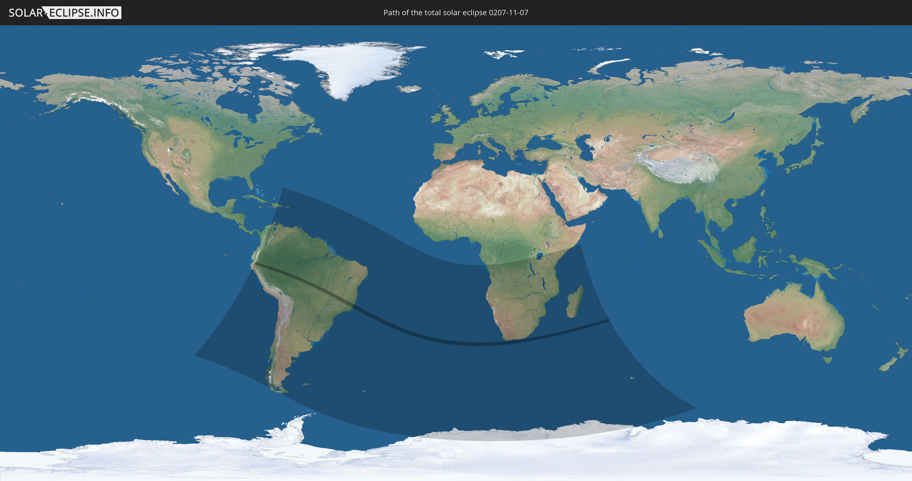
Total solar eclipse of 11/07/0207
| Day of week: | Saturday |
| Maximum duration of eclipse: | 03m55s |
| Maximum width of eclipse path: | 159 km |
| Saros cycle: | 75 |
| Coverage: | 100% |
| Magnitude: | 1.046 |
| Gamma: | -0.2711 |
Wo kann man die Sonnenfinsternis vom 11/07/0207 sehen?
Die Sonnenfinsternis am 11/07/0207 kann man in 63 Ländern als partielle Sonnenfinsternis beobachten.
Der Finsternispfad verläuft durch 4 Länder. Nur in diesen Ländern ist sie als total Sonnenfinsternis zu sehen.
In den folgenden Ländern ist die Sonnenfinsternis total zu sehen
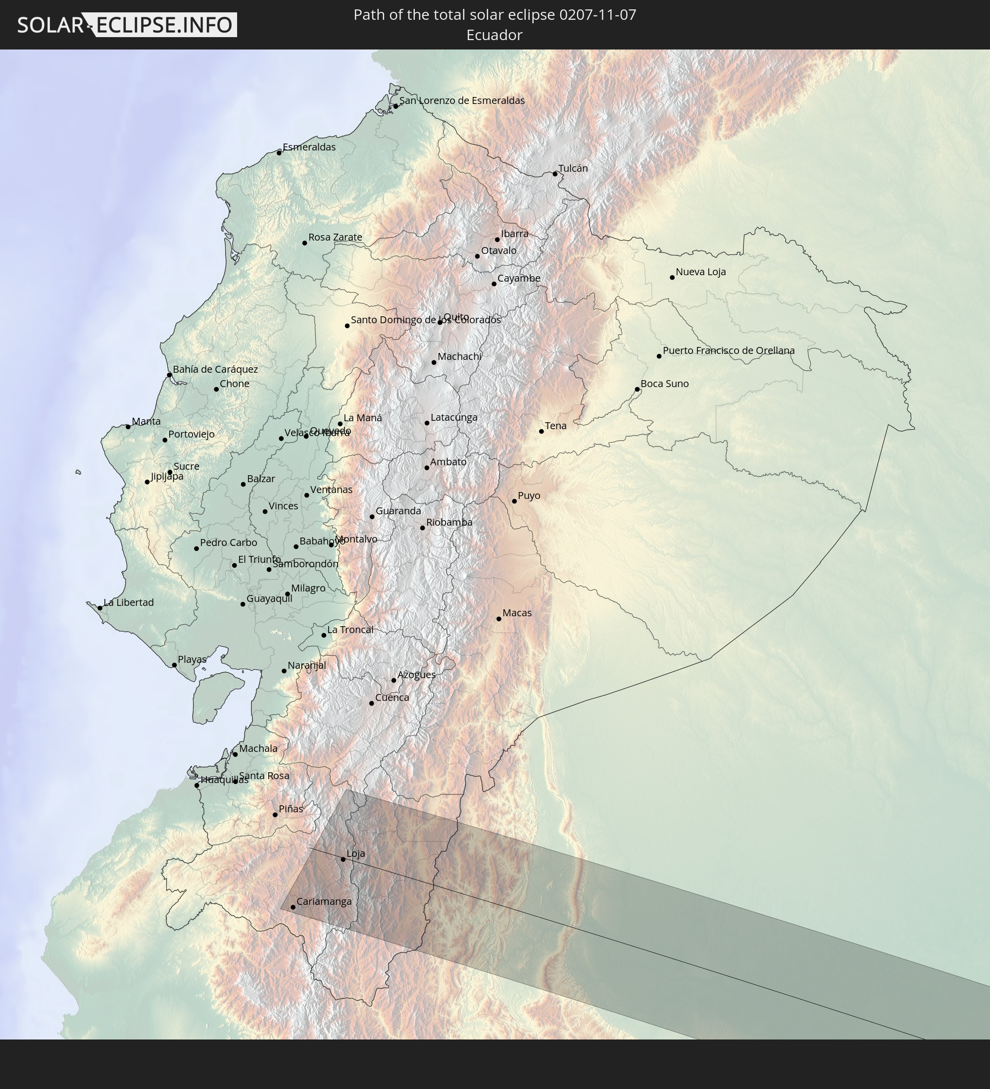 Ecuador
 Peru
Peru
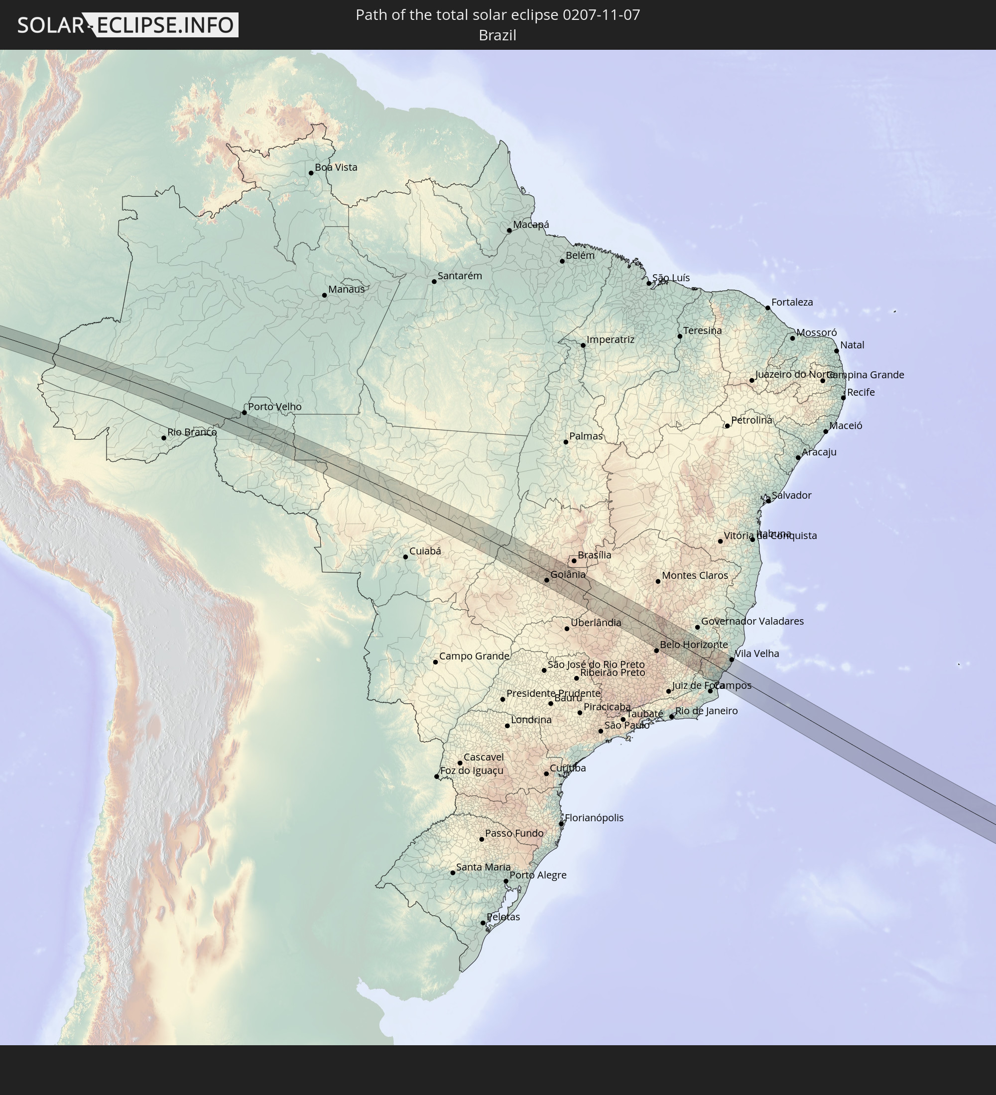 Brazil
 South Africa
In den folgenden Ländern ist die Sonnenfinsternis partiell zu sehen
 Antarctica
 Chile
Chile
 Ecuador
 Colombia
 Peru
Peru
 Brazil
 Argentina
 Venezuela
 Dominican Republic
 Aruba
Aruba
 Bolivia
 Puerto Rico
 United States Virgin Islands
 British Virgin Islands
 Anguilla
 Collectivity of Saint Martin
 Saint Barthélemy
 Saint Kitts and Nevis
 Paraguay
 Antigua and Barbuda
 Montserrat
 Trinidad and Tobago
 Guadeloupe
 Grenada
 Dominica
 Saint Vincent and the Grenadines
 Falkland Islands
 Guyana
 Martinique
 Saint Lucia
 Barbados
 Uruguay
 Suriname
 French Guiana
 South Georgia and the South Sandwich Islands
 Saint Helena, Ascension and Tristan da Cunha
 Bouvet Island
 Republic of the Congo
 Angola
 Namibia
 Democratic Republic of the Congo
 South Africa
 Botswana
 Zambia
 Zimbabwe
 Lesotho
 Rwanda
 Burundi
 Tanzania
 Uganda
 Mozambique
 Swaziland
 Malawi
 Kenya
Kenya
 French Southern and Antarctic Lands
 Somalia
 Madagascar
 Comoros
 Mayotte
 Seychelles
 Réunion
 Mauritius
 Heard Island and McDonald Islands
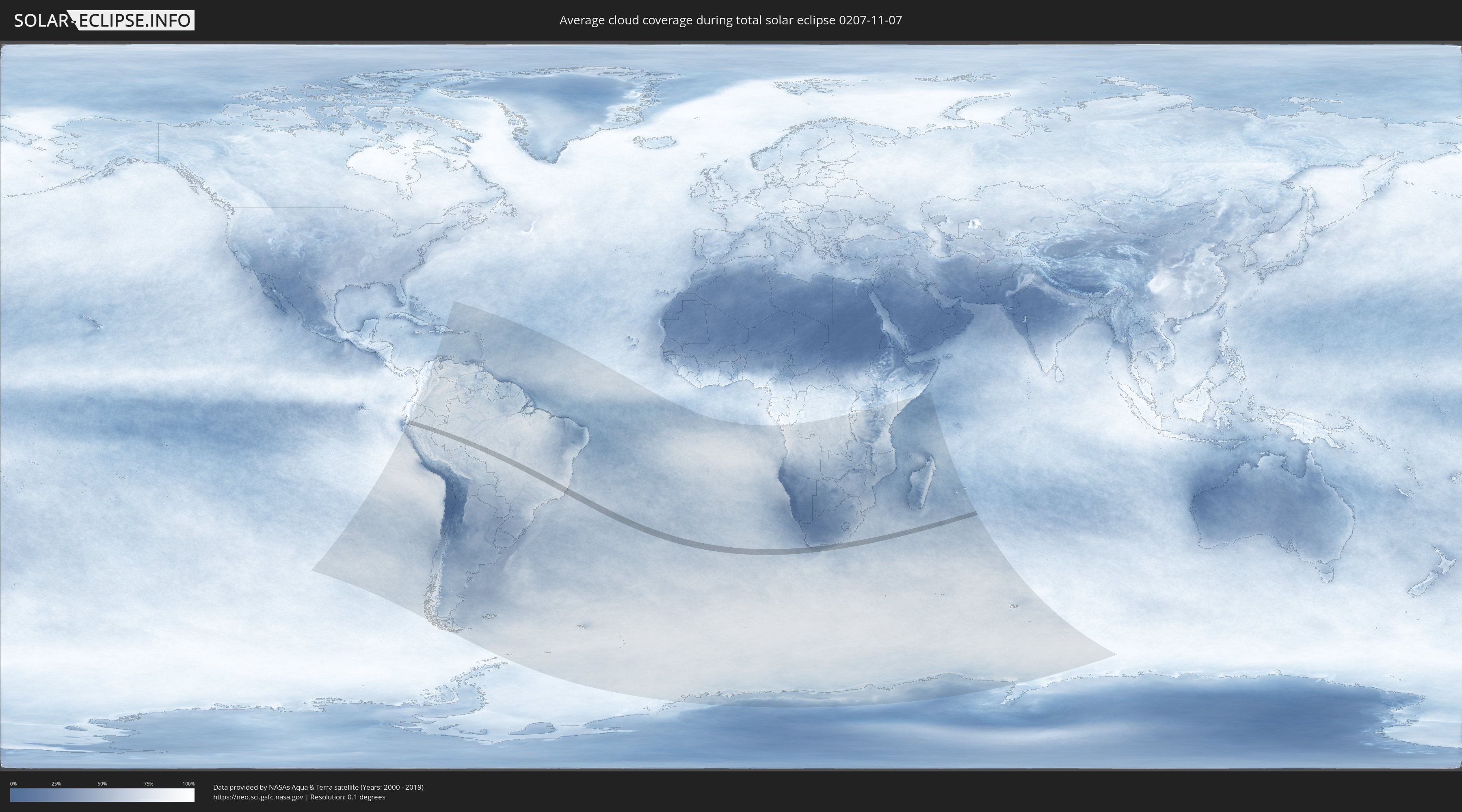
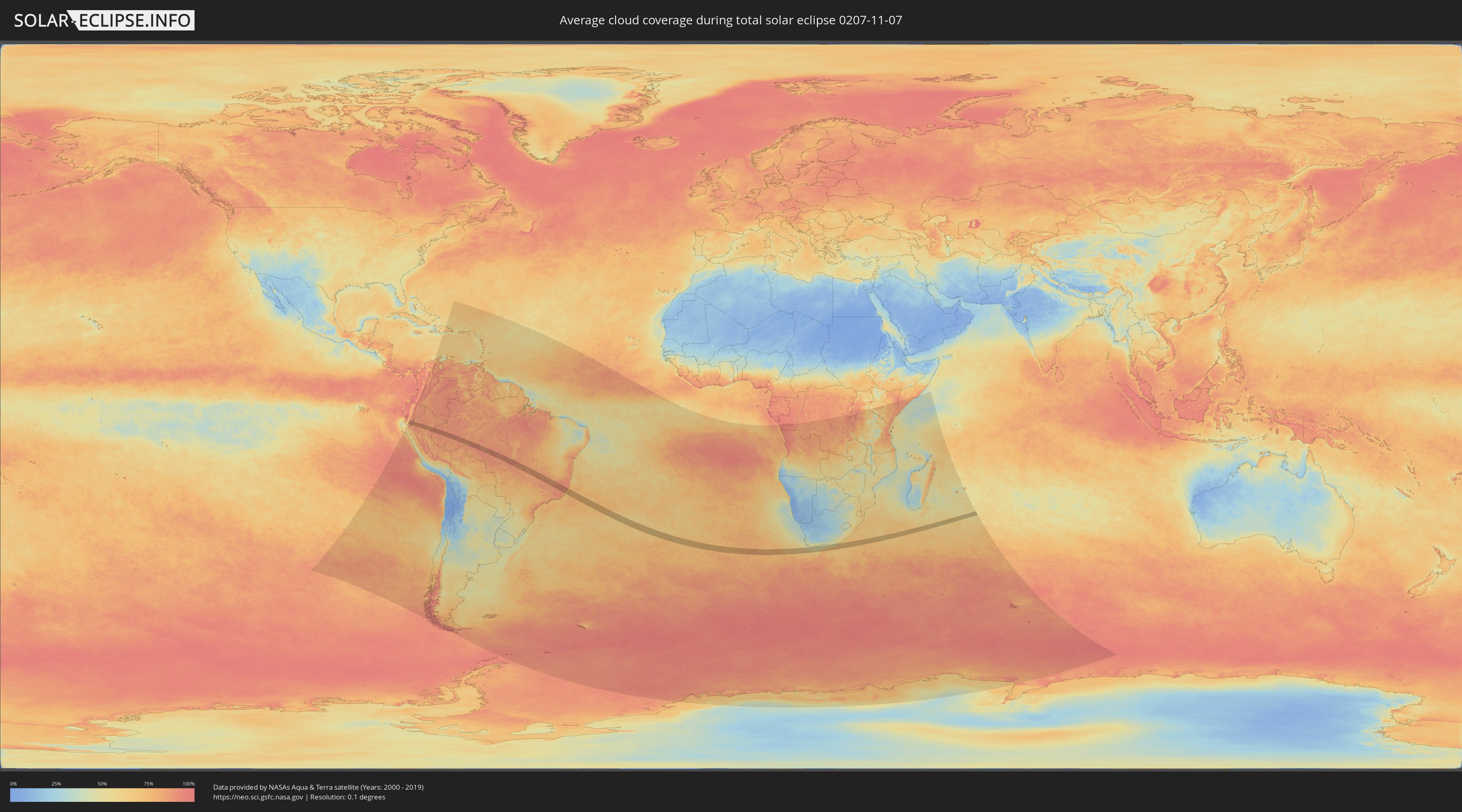
How will be the weather during the total solar eclipse on 11/07/0207?
Where is the best place to see the total solar eclipse of 11/07/0207?
The following maps show the average cloud coverage for the day of the total solar eclipse.
With the help of these maps, it is possible to find the place along the eclipse path, which has the best
chance of a cloudless sky.
Nevertheless, you should consider local circumstances and inform about the weather of your chosen
observation site.
The data is provided by NASAs satellites
AQUA and TERRA.
The cloud maps are averaged over a period of 19 years (2000 - 2019).
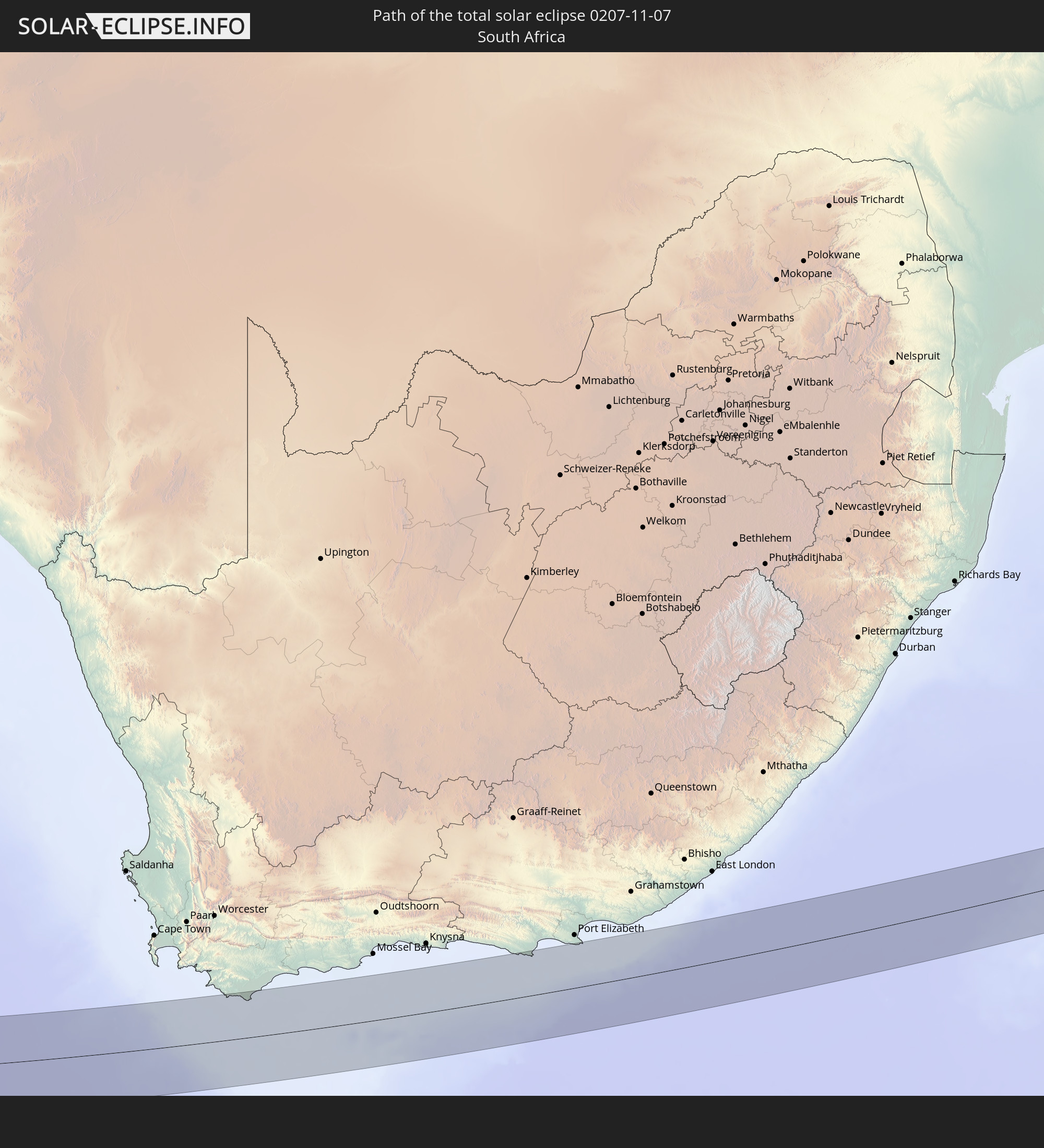
Detailed country maps
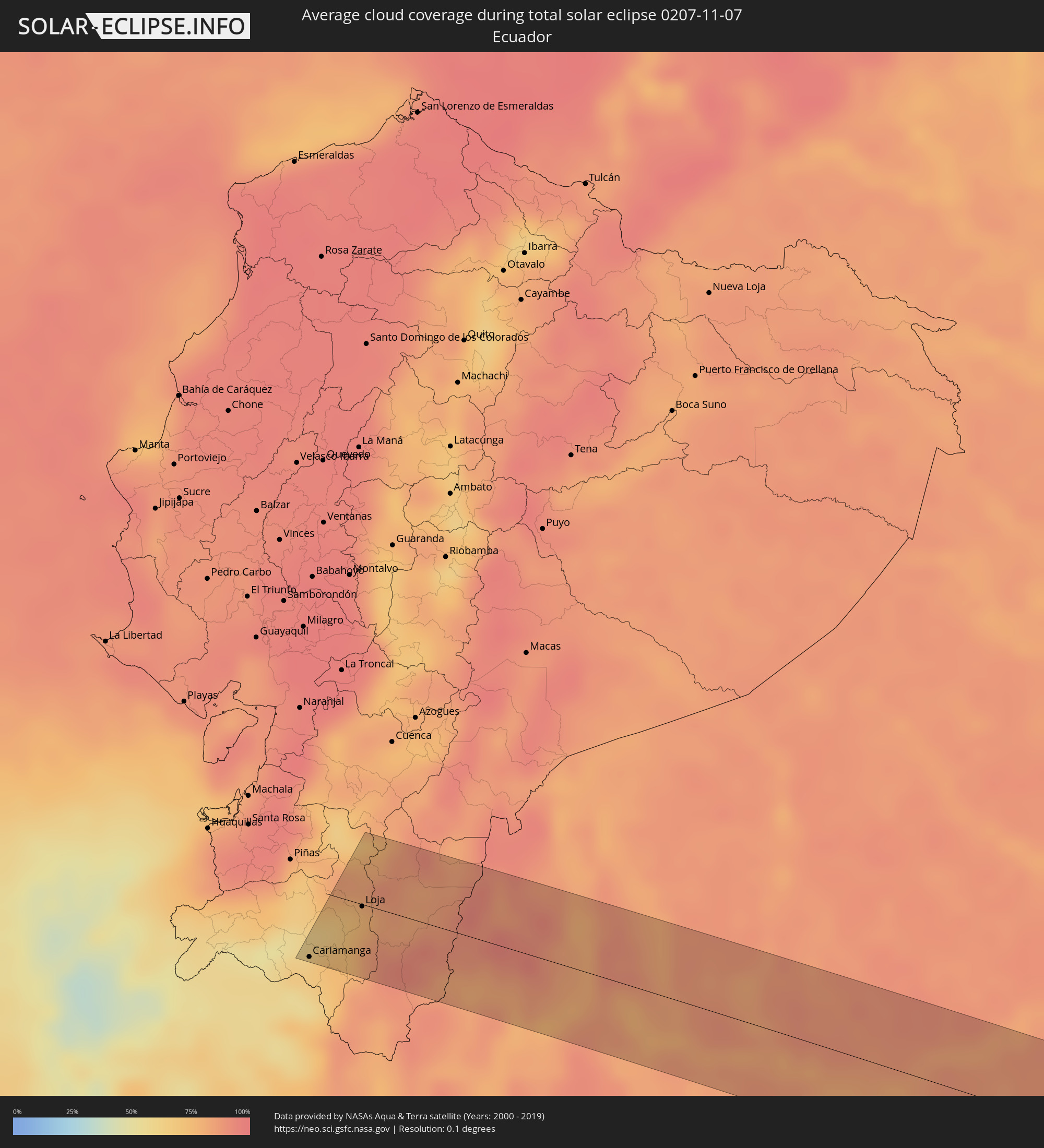 Ecuador
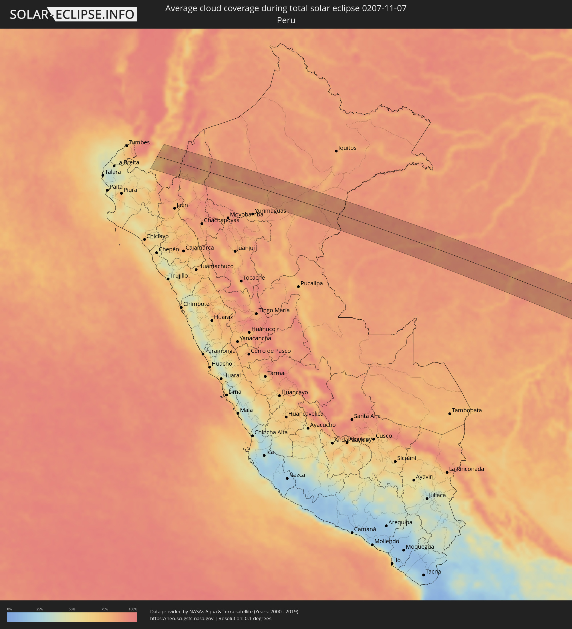 Peru
Peru
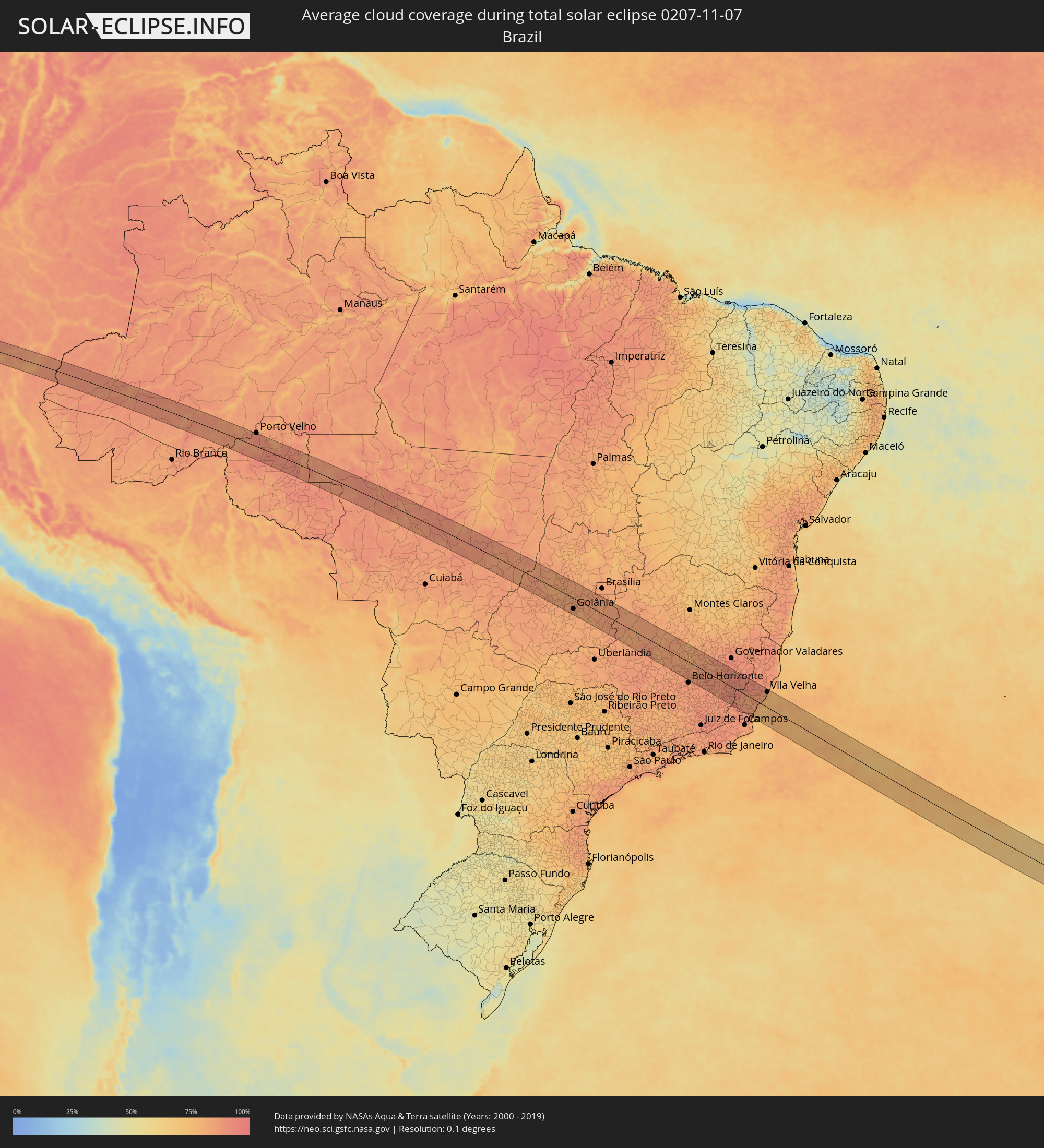 Brazil
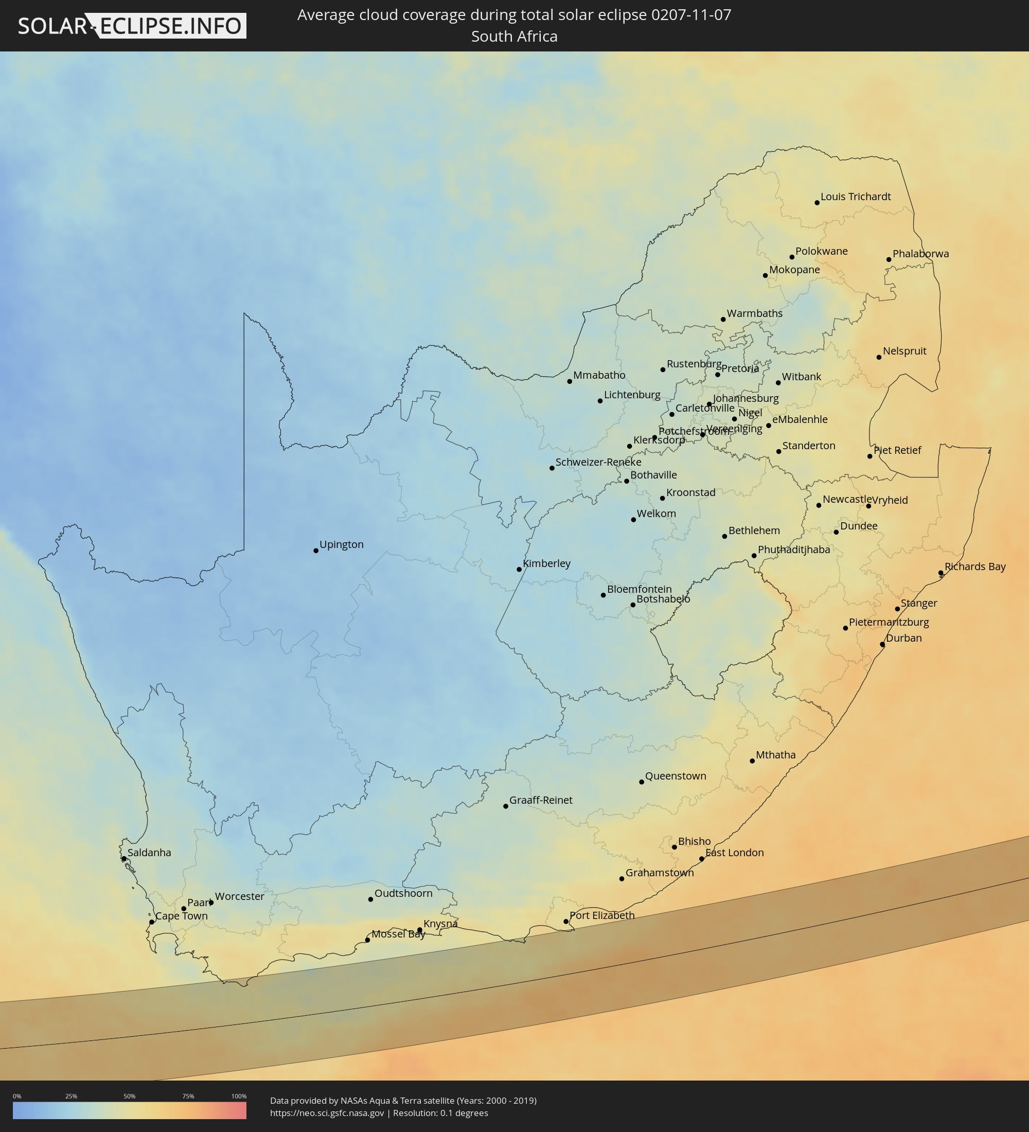 South Africa
Cities inside the path of the eclipse
The following table shows all locations with a population of more than 5,000 inside the eclipse path. Cities which have more than 100,000 inhabitants are marked bold. A click at the locations opens a detailed map.
| City | Type | Eclipse duration | Local time of max. eclipse | Distance to central line | Ø Cloud coverage |
|
Cariamanga, Loja
|
total | - | 05:46:04 UTC-05:14 | 48 km | 66% |
|
Catamayo, Loja
|
total | - | 05:45:48 UTC-05:14 | 6 km | 66% |
|
Loja, Loja
|
total | - | 05:45:47 UTC-05:14 | 2 km | 78% |
|
Zamora, Zamora-Chinchipe
|
total | - | 05:45:47 UTC-05:14 | 1 km | 87% |
|
Yantzaza, Zamora-Chinchipe
|
total | - | 05:45:36 UTC-05:14 | 30 km | 84% |
|
Barranca, Loreto
|
total | - | 05:51:22 UTC-05:08 | 9 km | 81% |
|
Lagunas, Loreto
|
total | - | 05:51:33 UTC-05:08 | 17 km | 81% |
|
Eirunepé, Amazonas
|
total | - | 06:58:34 UTC-04:02 | 42 km | 85% |
|
Ariquemes, Rondônia
|
total | - | 07:02:53 UTC-04:02 | 19 km | 92% |
|
Jaru, Rondônia
|
total | - | 07:03:36 UTC-04:02 | 48 km | 90% |
|
Goiás, Goiás
|
total | - | 08:13:47 UTC-03:06 | 18 km | 81% |
|
Anicuns, Goiás
|
total | - | 08:14:37 UTC-03:06 | 61 km | 84% |
|
Itapuranga, Goiás
|
total | - | 08:13:28 UTC-03:06 | 28 km | 81% |
|
Itaberaí, Goiás
|
total | - | 08:14:11 UTC-03:06 | 10 km | 82% |
|
Ceres, Goiás
|
total | - | 08:13:28 UTC-03:06 | 71 km | 83% |
|
Inhumas, Goiás
|
total | - | 08:14:55 UTC-03:06 | 27 km | 83% |
|
Trindade, Goiás
|
total | - | 08:15:19 UTC-03:06 | 55 km | 82% |
|
Goianira, Goiás
|
total | - | 08:15:10 UTC-03:06 | 37 km | 80% |
|
Jaraguá, Goiás
|
total | - | 08:14:17 UTC-03:06 | 40 km | 82% |
|
Goiânia, Goiás
|
total | - | 08:15:34 UTC-03:06 | 46 km | 79% |
|
Aparecida de Goiânia, Goiás
|
total | - | 08:15:46 UTC-03:06 | 60 km | 80% |
|
Nerópolis, Goiás
|
total | - | 08:15:15 UTC-03:06 | 18 km | 80% |
|
Senador Canedo, Goiás
|
total | - | 08:15:46 UTC-03:06 | 41 km | 80% |
|
Pirenópolis, Goiás
|
total | - | 08:14:46 UTC-03:06 | 50 km | 83% |
|
Bela Vista de Goiás, Goiás
|
total | - | 08:16:15 UTC-03:06 | 60 km | 82% |
|
Anápolis, Goiás
|
total | - | 08:15:24 UTC-03:06 | 3 km | 83% |
|
Pires do Rio, Goiás
|
total | - | 08:17:21 UTC-03:06 | 57 km | 81% |
|
Luziânia, Goiás
|
total | - | 08:16:17 UTC-03:06 | 62 km | 83% |
|
Cristalina, Goiás
|
total | - | 08:17:18 UTC-03:06 | 28 km | 83% |
|
Vazante, Minas Gerais
|
total | - | 08:19:42 UTC-03:06 | 54 km | 80% |
|
Paracatu, Minas Gerais
|
total | - | 08:18:42 UTC-03:06 | 22 km | 81% |
|
Presidente Olegário, Minas Gerais
|
total | - | 08:20:50 UTC-03:06 | 71 km | 85% |
|
João Pinheiro, Minas Gerais
|
total | - | 08:20:10 UTC-03:06 | 8 km | 82% |
|
Pompéu, Minas Gerais
|
total | - | 08:23:38 UTC-03:06 | 72 km | 85% |
|
Corinto, Minas Gerais
|
total | - | 08:23:01 UTC-03:06 | 35 km | 81% |
|
Curvelo, Minas Gerais
|
total | - | 08:23:34 UTC-03:06 | 0 km | 81% |
|
Sete Lagoas, Minas Gerais
|
total | - | 08:24:48 UTC-03:06 | 59 km | 85% |
|
Pedro Leopoldo, Minas Gerais
|
total | - | 08:25:16 UTC-03:06 | 64 km | 86% |
|
Santa Luzia, Minas Gerais
|
total | - | 08:25:43 UTC-03:06 | 68 km | 84% |
|
Caeté, Minas Gerais
|
total | - | 08:26:06 UTC-03:06 | 69 km | 87% |
|
Barão de Cocais, Minas Gerais
|
total | - | 08:26:25 UTC-03:06 | 66 km | 88% |
|
Serro, Minas Gerais
|
total | - | 08:24:38 UTC-03:06 | 69 km | 85% |
|
Itabira, Minas Gerais
|
total | - | 08:26:17 UTC-03:06 | 21 km | 88% |
|
João Monlevade, Minas Gerais
|
total | - | 08:26:37 UTC-03:06 | 37 km | 88% |
|
Nova Era, Minas Gerais
|
total | - | 08:26:42 UTC-03:06 | 24 km | 88% |
|
Timóteo, Minas Gerais
|
total | - | 08:26:57 UTC-03:06 | 13 km | 85% |
|
Santana do Paraíso, Minas Gerais
|
total | - | 08:26:45 UTC-03:06 | 38 km | 89% |
|
Açucena, Minas Gerais
|
total | - | 08:26:21 UTC-03:06 | 67 km | 88% |
|
Ipatinga, Minas Gerais
|
total | - | 08:26:56 UTC-03:06 | 29 km | 85% |
|
Belo Oriente, Minas Gerais
|
total | - | 08:26:39 UTC-03:06 | 56 km | 85% |
|
Ipaba, Minas Gerais
|
total | - | 08:27:01 UTC-03:06 | 41 km | 85% |
|
Matipó, Minas Gerais
|
total | - | 08:28:22 UTC-03:06 | 39 km | 90% |
|
Bom Jesus do Galho, Minas Gerais
|
total | - | 08:27:45 UTC-03:06 | 6 km | 89% |
|
Caratinga, Minas Gerais
|
total | - | 08:27:55 UTC-03:06 | 19 km | 91% |
|
Inhapim, Minas Gerais
|
total | - | 08:27:36 UTC-03:06 | 43 km | 89% |
|
Manhuaçu, Minas Gerais
|
total | - | 08:28:44 UTC-03:06 | 20 km | 90% |
|
Carangola, Minas Gerais
|
total | - | 08:29:26 UTC-03:06 | 66 km | 88% |
|
Manhumirim, Minas Gerais
|
total | - | 08:28:59 UTC-03:06 | 26 km | 91% |
|
Espera Feliz, Minas Gerais
|
total | - | 08:29:29 UTC-03:06 | 52 km | 89% |
|
Guaçuí, Espírito Santo
|
total | - | 08:29:58 UTC-03:06 | 52 km | 89% |
|
Lajinha, Minas Gerais
|
total | - | 08:29:08 UTC-03:06 | 11 km | 88% |
|
Iúna, Espírito Santo
|
total | - | 08:29:32 UTC-03:06 | 3 km | 88% |
|
Alegre, Espírito Santo
|
total | - | 08:30:09 UTC-03:06 | 43 km | 86% |
|
Mutum, Minas Gerais
|
total | - | 08:28:52 UTC-03:06 | 55 km | 90% |
|
Mimoso do Sul, Espírito Santo
|
total | - | 08:30:49 UTC-03:06 | 63 km | 89% |
|
Castelo, Espírito Santo
|
total | - | 08:30:23 UTC-03:06 | 9 km | 83% |
|
Afonso Cláudio, Espírito Santo
|
total | - | 08:29:41 UTC-03:06 | 45 km | 89% |
|
Cachoeiro de Itapemirim, Espírito Santo
|
total | - | 08:30:51 UTC-03:06 | 29 km | 85% |
|
Itapemirim, Espírito Santo
|
total | - | 08:31:28 UTC-03:06 | 30 km | 79% |
|
Marataizes, Espírito Santo
|
total | - | 08:31:32 UTC-03:06 | 33 km | 79% |
|
Piúma, Espírito Santo
|
total | - | 08:31:22 UTC-03:06 | 8 km | 79% |
|
Guarapari, Espírito Santo
|
total | - | 08:31:24 UTC-03:06 | 22 km | 77% |
|
Viana, Espírito Santo
|
total | - | 08:31:01 UTC-03:06 | 47 km | 84% |
|
Vila Velha, Espírito Santo
|
total | - | 08:31:13 UTC-03:06 | 64 km | 82% |