Total solar eclipse of 06/27/0382
| Day of week: | Sunday |
| Maximum duration of eclipse: | 04m03s |
| Maximum width of eclipse path: | 204 km |
| Saros cycle: | 91 |
| Coverage: | 100% |
| Magnitude: | 1.0538 |
| Gamma: | 0.4878 |
Wo kann man die Sonnenfinsternis vom 06/27/0382 sehen?
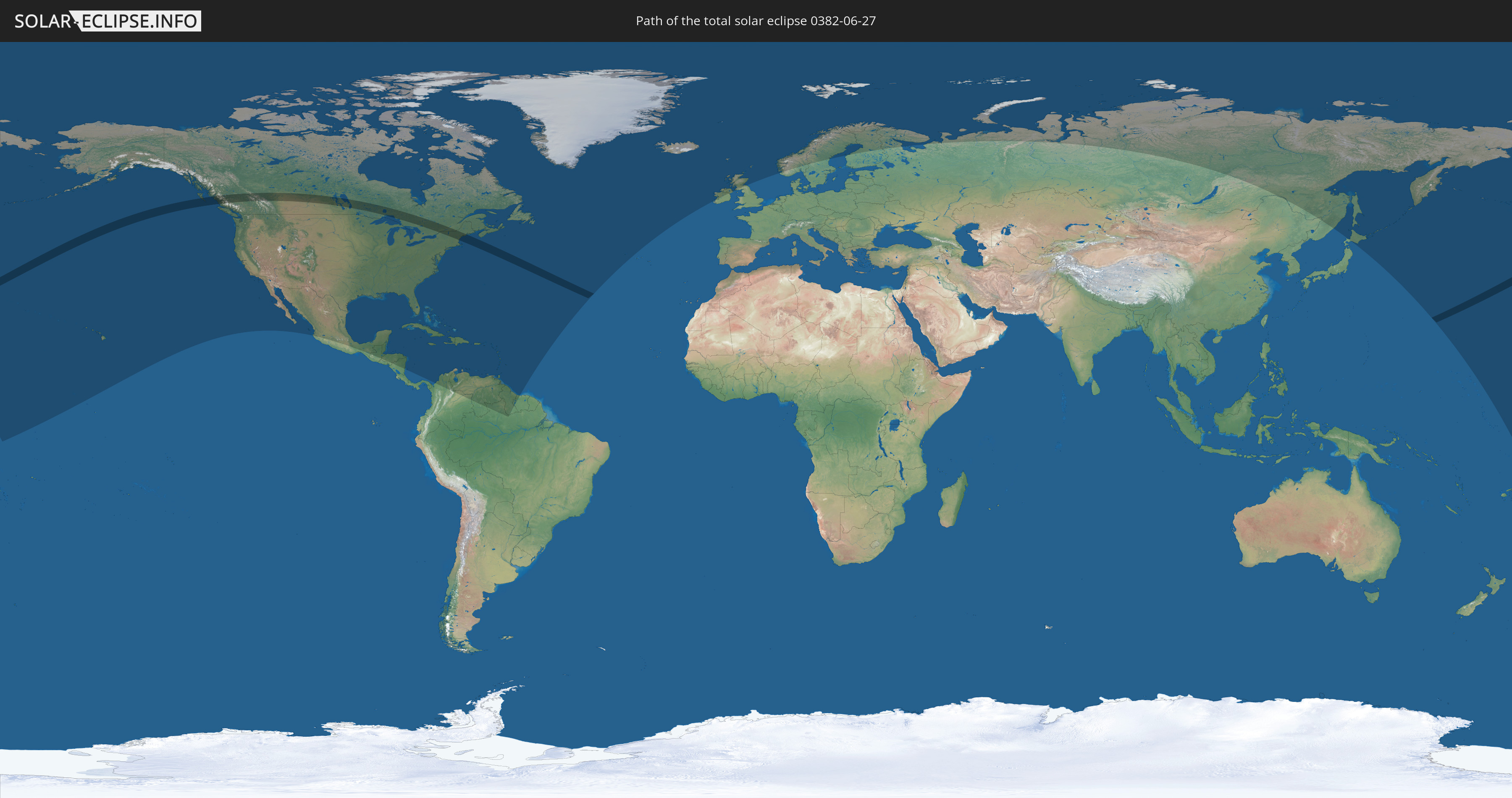
Die Sonnenfinsternis am 06/27/0382 kann man in 55 Ländern als partielle Sonnenfinsternis beobachten.
Der Finsternispfad verläuft durch 2 Länder. Nur in diesen Ländern ist sie als total Sonnenfinsternis zu sehen.
In den folgenden Ländern ist die Sonnenfinsternis total zu sehen
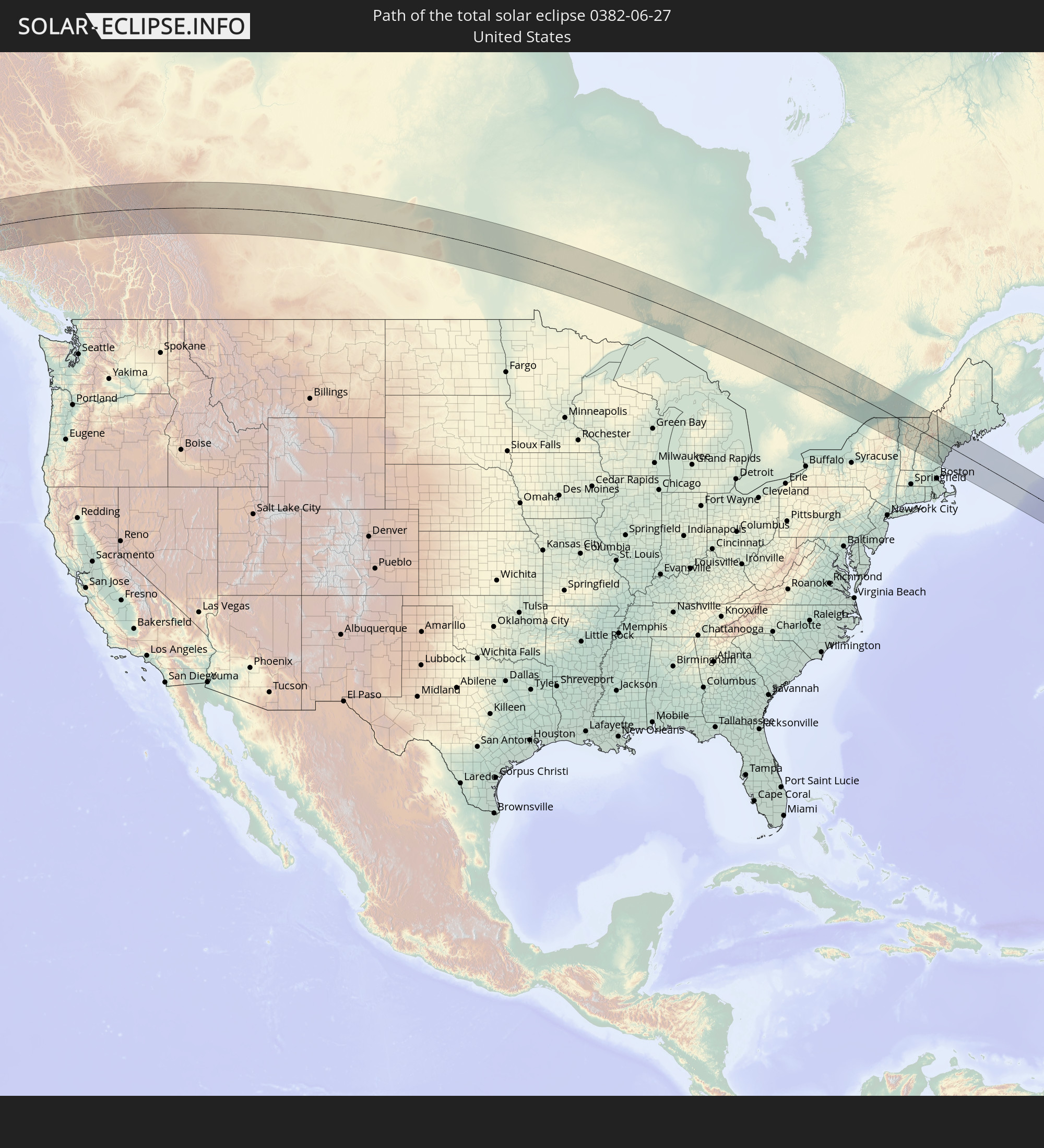 United States
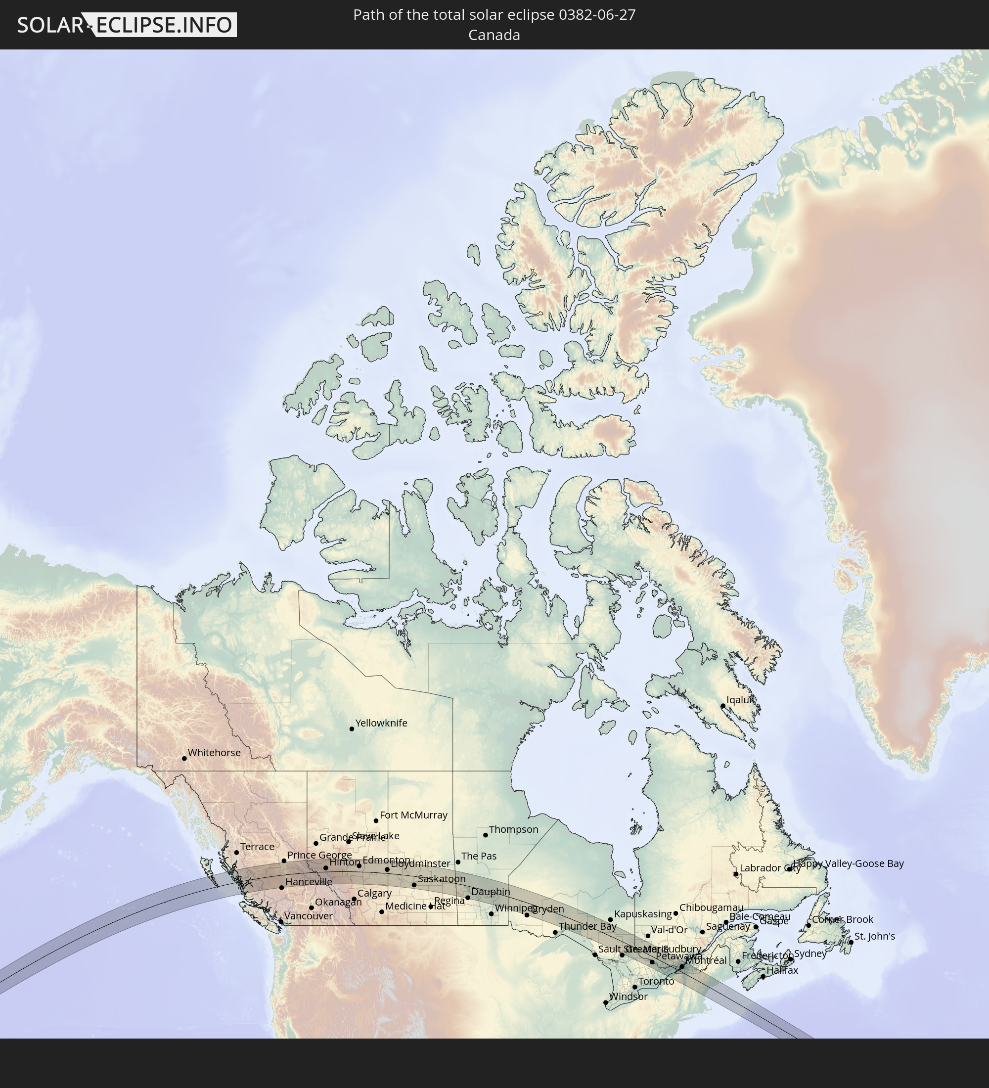 Canada
In den folgenden Ländern ist die Sonnenfinsternis partiell zu sehen
 Russia
 United States
 United States Minor Outlying Islands
 Kiribati
 Canada
 Mexico
 Greenland
 Guatemala
 Honduras
 Belize
 Nicaragua
 Cuba
Cuba
 Colombia
 Cayman Islands
 The Bahamas
 Jamaica
 Haiti
Haiti
 Brazil
 Venezuela
 Turks and Caicos Islands
 Dominican Republic
 Aruba
Aruba
 Puerto Rico
 United States Virgin Islands
 Bermuda
 British Virgin Islands
 Anguilla
 Collectivity of Saint Martin
 Saint Barthélemy
 Saint Kitts and Nevis
 Antigua and Barbuda
 Montserrat
 Trinidad and Tobago
 Guadeloupe
 Grenada
 Dominica
 Saint Vincent and the Grenadines
 Guyana
 Martinique
 Saint Lucia
 Barbados
 Suriname
 Saint Pierre and Miquelon
 Portugal
 Iceland
 Republic of Ireland
 Svalbard and Jan Mayen
 United Kingdom
 Faroe Islands
 Norway
 Sweden
 Finland
 China
China
 Japan
Japan
 Marshall Islands
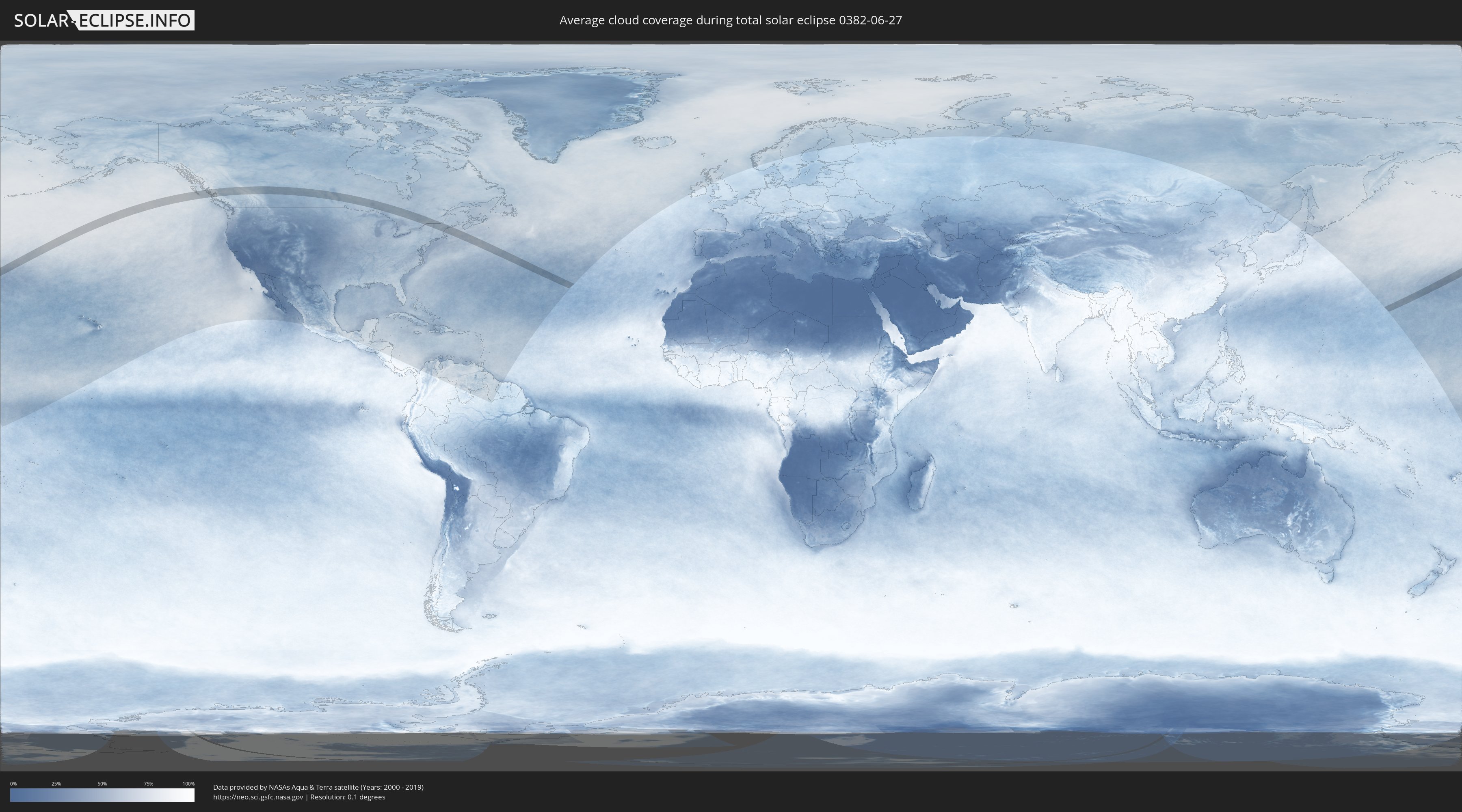
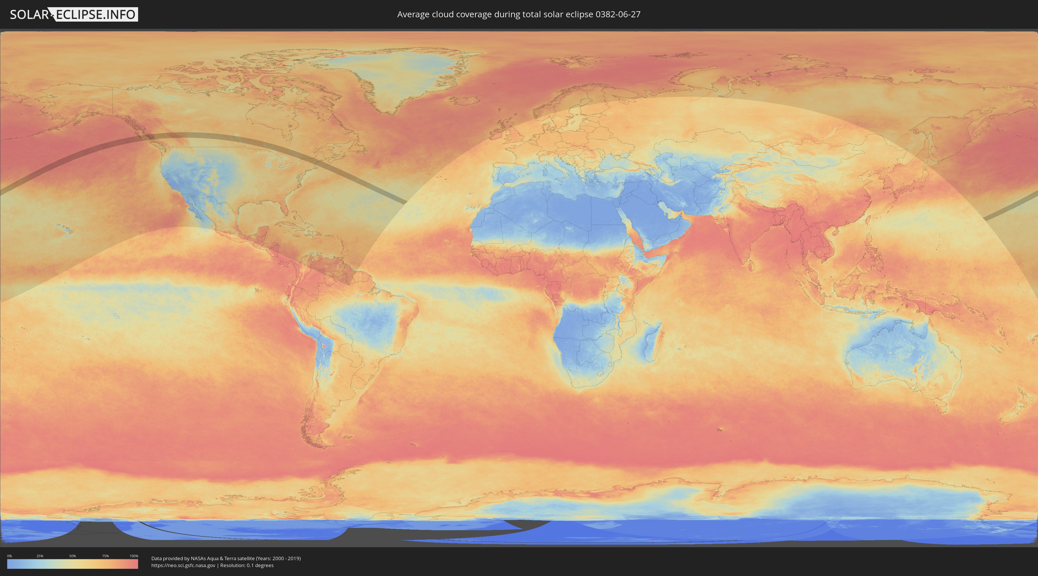
How will be the weather during the total solar eclipse on 06/27/0382?
Where is the best place to see the total solar eclipse of 06/27/0382?
The following maps show the average cloud coverage for the day of the total solar eclipse.
With the help of these maps, it is possible to find the place along the eclipse path, which has the best
chance of a cloudless sky.
Nevertheless, you should consider local circumstances and inform about the weather of your chosen
observation site.
The data is provided by NASAs satellites
AQUA and TERRA.
The cloud maps are averaged over a period of 19 years (2000 - 2019).
Detailed country maps
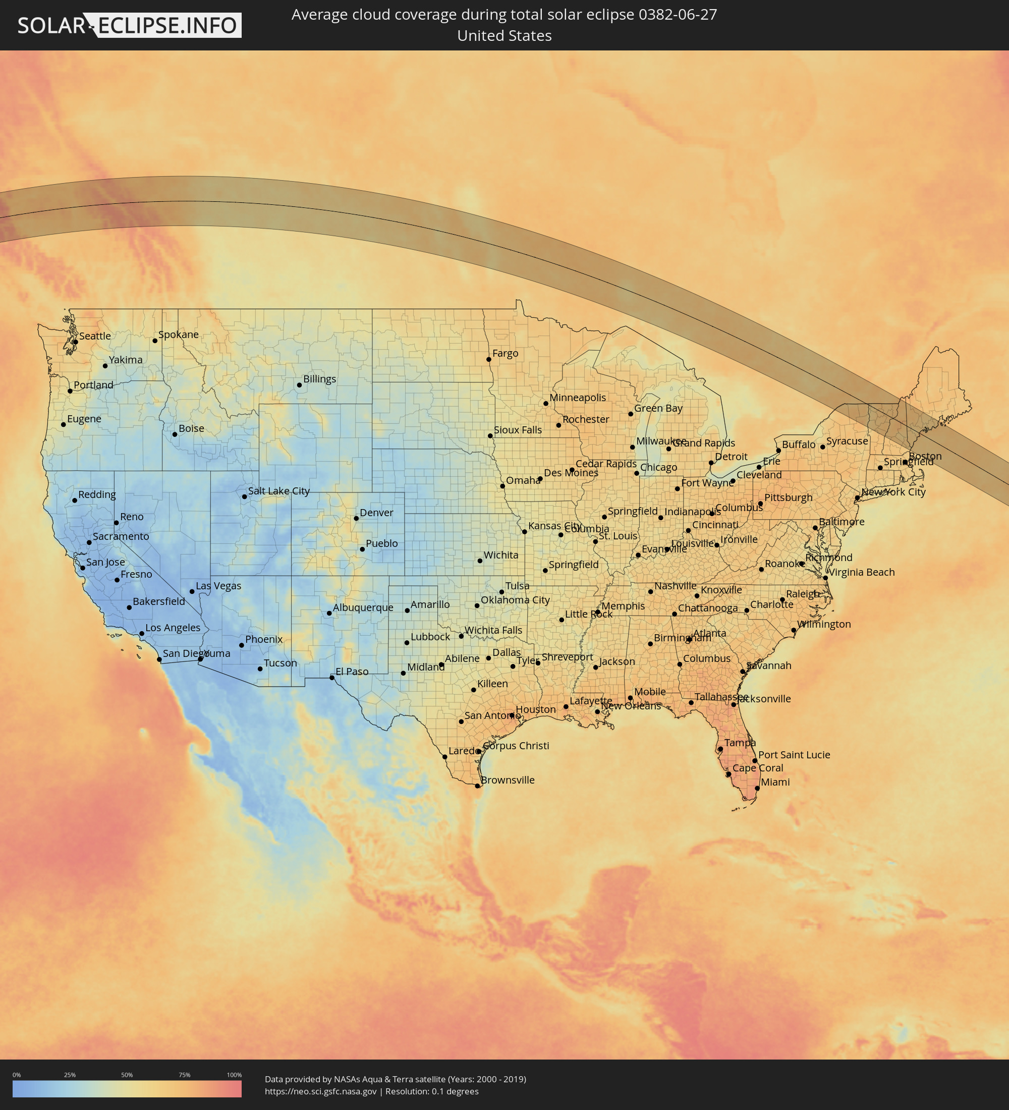 United States
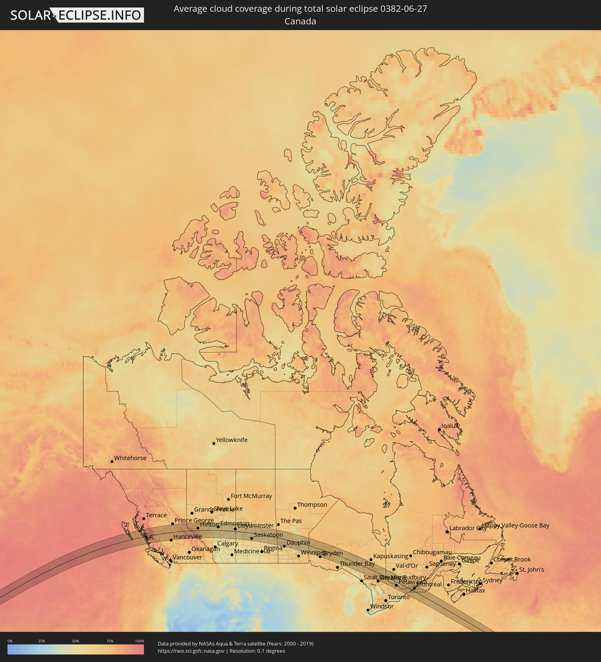 Canada
Cities inside the path of the eclipse
The following table shows all locations with a population of more than 5,000 inside the eclipse path. Cities which have more than 100,000 inhabitants are marked bold. A click at the locations opens a detailed map.
| City | Type | Eclipse duration | Local time of max. eclipse | Distance to central line | Ø Cloud coverage |
|
Quesnel, British Columbia
|
total | - | 12:02:33 UTC-08:00 | 3 km | 68% |
|
Williams Lake, British Columbia
|
total | - | 12:02:53 UTC-08:00 | 94 km | 70% |
|
Hinton, Alberta
|
total | - | 12:36:09 UTC-07:33 | 27 km | 69% |
|
Edson, Alberta
|
total | - | 12:37:52 UTC-07:33 | 45 km | 69% |
|
Sylvan Lake, Alberta
|
total | - | 12:41:38 UTC-07:33 | 95 km | 52% |
|
Stony Plain, Alberta
|
total | - | 12:41:29 UTC-07:33 | 40 km | 57% |
|
Spruce Grove, Alberta
|
total | - | 12:41:36 UTC-07:33 | 41 km | 57% |
|
Red Deer, Alberta
|
total | - | 12:42:05 UTC-07:33 | 101 km | 57% |
|
Lacombe, Alberta
|
total | - | 12:42:09 UTC-07:33 | 79 km | 56% |
|
Morinville, Alberta
|
total | - | 12:41:55 UTC-07:33 | 72 km | 57% |
|
Leduc, Alberta
|
total | - | 12:42:13 UTC-07:33 | 12 km | 56% |
|
Edmonton, Alberta
|
total | - | 12:42:15 UTC-07:33 | 43 km | 64% |
|
Beaumont, Alberta
|
total | - | 12:42:23 UTC-07:33 | 22 km | 58% |
|
Silver Berry, Alberta
|
total | - | 12:42:25 UTC-07:33 | 34 km | 62% |
|
Wild Rose, Alberta
|
total | - | 12:42:24 UTC-07:33 | 35 km | 62% |
|
Wetaskiwin, Alberta
|
total | - | 12:42:34 UTC-07:33 | 23 km | 56% |
|
Fort Saskatchewan, Alberta
|
total | - | 12:42:35 UTC-07:33 | 65 km | 58% |
|
Camrose, Alberta
|
total | - | 12:43:21 UTC-07:33 | 19 km | 56% |
|
Lloydminster, Saskatchewan
|
total | - | 12:47:25 UTC-07:33 | 27 km | 59% |
|
North Battleford, Saskatchewan
|
total | - | 13:25:25 UTC-06:58 | 24 km | 57% |
|
Saskatoon, Saskatchewan
|
total | - | 13:28:09 UTC-06:58 | 76 km | 58% |
|
Prince Albert, Saskatchewan
|
total | - | 13:28:44 UTC-06:58 | 51 km | 61% |
|
Dauphin, Manitoba
|
total | - | 14:36:52 UTC-06:00 | 101 km | 63% |
|
Timmins, Ontario
|
total | - | 16:01:04 UTC-05:00 | 73 km | 69% |
|
Kirkland Lake, Ontario
|
total | - | 16:02:36 UTC-05:00 | 80 km | 65% |
|
Temiskaming Shores, Ontario
|
total | - | 16:03:49 UTC-05:00 | 28 km | 63% |
|
North Bay, Ontario
|
total | - | 16:05:44 UTC-05:00 | 84 km | 65% |
|
Petawawa, Ontario
|
total | - | 16:08:01 UTC-05:00 | 50 km | 62% |
|
Pembroke, Ontario
|
total | - | 16:08:15 UTC-05:00 | 55 km | 61% |
|
Renfrew, Ontario
|
total | - | 16:09:05 UTC-05:00 | 75 km | 66% |
|
Arnprior, Ontario
|
total | - | 16:09:22 UTC-05:00 | 63 km | 70% |
|
Carleton Place, Ontario
|
total | - | 16:09:56 UTC-05:00 | 86 km | 69% |
|
Bells Corners, Ontario
|
total | - | 16:09:54 UTC-05:00 | 56 km | 72% |
|
le Plateau, Quebec
|
total | - | 16:09:45 UTC-05:00 | 42 km | 71% |
|
Ottawa, Ontario
|
total | - | 16:09:51 UTC-05:00 | 42 km | 72% |
|
Val-des-Monts, Quebec
|
total | - | 16:09:31 UTC-05:00 | 18 km | 66% |
|
Mont-Laurier, Quebec
|
total | - | 16:08:18 UTC-05:00 | 78 km | 67% |
|
Clarence-Rockland, Ontario
|
total | - | 16:09:55 UTC-05:00 | 13 km | 68% |
|
Potsdam, New York
|
total | - | 16:11:25 UTC-05:00 | 88 km | 70% |
|
Massena, New York
|
total | - | 16:11:05 UTC-05:00 | 60 km | 70% |
|
Cornwall, Ontario
|
total | - | 16:11:04 UTC-05:00 | 45 km | 66% |
|
Hawkesbury, Ontario
|
total | - | 16:10:17 UTC-05:00 | 17 km | 72% |
|
Mont-Tremblant, Quebec
|
total | - | 16:09:23 UTC-05:00 | 78 km | 70% |
|
Brownsburg-Chatham, Quebec
|
total | - | 16:10:17 UTC-05:00 | 32 km | 70% |
|
Lachute, Quebec
|
total | - | 16:10:23 UTC-05:00 | 32 km | 70% |
|
Malone, New York
|
total | - | 16:11:35 UTC-05:00 | 45 km | 73% |
|
Saint-Zotique, Quebec
|
total | - | 16:11:02 UTC-05:00 | 20 km | 66% |
|
Les Coteaux, Quebec
|
total | - | 16:10:59 UTC-05:00 | 21 km | 66% |
|
Saint-Sauveur, Quebec
|
total | - | 16:10:08 UTC-05:00 | 61 km | 72% |
|
Saint-Lazare, Quebec
|
total | - | 16:10:53 UTC-05:00 | 25 km | 70% |
|
Salaberry-de-Valleyfield, Quebec
|
total | - | 16:11:06 UTC-05:00 | 12 km | 67% |
|
Sainte-Adèle, Quebec
|
total | - | 16:10:04 UTC-05:00 | 69 km | 73% |
|
Saranac Lake, New York
|
total | - | 16:12:27 UTC-05:00 | 90 km | 72% |
|
Prévost, Quebec
|
total | - | 16:10:13 UTC-05:00 | 62 km | 72% |
|
Mirabel, Quebec
|
total | - | 16:10:32 UTC-05:00 | 41 km | 72% |
|
Vaudreuil-Dorion, Quebec
|
total | - | 16:10:57 UTC-05:00 | 23 km | 68% |
|
Saint-Hippolyte, Quebec
|
total | - | 16:10:10 UTC-05:00 | 71 km | 72% |
|
Saint-Jérôme, Quebec
|
total | - | 16:10:24 UTC-05:00 | 57 km | 74% |
|
Pincourt, Quebec
|
total | - | 16:11:00 UTC-05:00 | 21 km | 68% |
|
L'Île-Perrot, Quebec
|
total | - | 16:11:01 UTC-05:00 | 21 km | 66% |
|
Notre-Dame-de-l'Île-Perrot, Quebec
|
total | - | 16:11:03 UTC-05:00 | 19 km | 66% |
|
Sainte-Marthe-sur-le-Lac, Quebec
|
total | - | 16:10:48 UTC-05:00 | 38 km | 64% |
|
Deux-Montagnes, Quebec
|
total | - | 16:10:49 UTC-05:00 | 38 km | 64% |
|
Blainville, Quebec
|
total | - | 16:10:38 UTC-05:00 | 53 km | 72% |
|
Beauharnois, Quebec
|
total | - | 16:11:10 UTC-05:00 | 16 km | 68% |
|
Kirkland, Quebec
|
total | - | 16:10:58 UTC-05:00 | 30 km | 64% |
|
Beaconsfield, Quebec
|
total | - | 16:11:00 UTC-05:00 | 28 km | 66% |
|
Dollard-Des Ormeaux, Quebec
|
total | - | 16:10:56 UTC-05:00 | 36 km | 66% |
|
Sainte-Anne-des-Plaines, Quebec
|
total | - | 16:10:32 UTC-05:00 | 65 km | 72% |
|
Rosemère, Quebec
|
total | - | 16:10:45 UTC-05:00 | 51 km | 69% |
|
Lorraine, Quebec
|
total | - | 16:10:41 UTC-05:00 | 57 km | 70% |
|
Saint-Lin-Laurentides, Quebec
|
total | - | 16:10:26 UTC-05:00 | 75 km | 72% |
|
Dorval, Quebec
|
total | - | 16:11:03 UTC-05:00 | 34 km | 65% |
|
Mercier, Quebec
|
total | - | 16:11:14 UTC-05:00 | 24 km | 70% |
|
Bois-des-Filion, Quebec
|
total | - | 16:10:43 UTC-05:00 | 56 km | 69% |
|
Rawdon, Quebec
|
total | - | 16:10:11 UTC-05:00 | 94 km | 72% |
|
Hampstead, Quebec
|
total | - | 16:11:03 UTC-05:00 | 41 km | 66% |
|
Mont-Royal, Quebec
|
total | - | 16:11:00 UTC-05:00 | 45 km | 67% |
|
Terrebonne, Quebec
|
total | - | 16:10:44 UTC-05:00 | 62 km | 70% |
|
Saint-Raymond, Quebec
|
total | - | 16:11:06 UTC-05:00 | 43 km | 67% |
|
Westmount, Quebec
|
total | - | 16:11:05 UTC-05:00 | 45 km | 67% |
|
Montréal, Quebec
|
total | - | 16:11:03 UTC-05:00 | 47 km | 67% |
|
Saint-Constant, Quebec
|
total | - | 16:11:17 UTC-05:00 | 39 km | 68% |
|
Delson, Quebec
|
total | - | 16:11:17 UTC-05:00 | 40 km | 70% |
|
Candiac, Quebec
|
total | - | 16:11:17 UTC-05:00 | 36 km | 70% |
|
La Prairie, Quebec
|
total | - | 16:11:15 UTC-05:00 | 40 km | 70% |
|
Plattsburgh, New York
|
total | - | 16:12:20 UTC-05:00 | 28 km | 70% |
|
Repentigny, Quebec
|
total | - | 16:10:48 UTC-05:00 | 74 km | 69% |
|
Varennes, Quebec
|
total | - | 16:10:53 UTC-05:00 | 70 km | 70% |
|
L'Assomption, Quebec
|
total | - | 16:10:41 UTC-05:00 | 83 km | 66% |
|
Sainte-Julie, Quebec
|
total | - | 16:11:06 UTC-05:00 | 63 km | 71% |
|
Carignan, Quebec
|
total | - | 16:11:19 UTC-05:00 | 51 km | 71% |
|
Saint-Basile-le-Grand, Quebec
|
total | - | 16:11:12 UTC-05:00 | 60 km | 71% |
|
Chambly, Quebec
|
total | - | 16:11:20 UTC-05:00 | 51 km | 71% |
|
Lavaltrie, Quebec
|
total | - | 16:10:41 UTC-05:00 | 95 km | 66% |
|
Saint-Jean-sur-Richelieu, Quebec
|
total | - | 16:11:33 UTC-05:00 | 38 km | 70% |
|
Otterburn Park, Quebec
|
total | - | 16:11:15 UTC-05:00 | 62 km | 73% |
|
Burlington, Vermont
|
total | - | 16:12:48 UTC-05:00 | 41 km | 63% |
|
Mont-Saint-Hilaire, Quebec
|
total | - | 16:11:12 UTC-05:00 | 66 km | 72% |
|
Beloeil, Quebec
|
total | - | 16:11:12 UTC-05:00 | 66 km | 72% |
|
Winooski, Vermont
|
total | - | 16:12:48 UTC-05:00 | 39 km | 63% |
|
South Burlington, Vermont
|
total | - | 16:12:51 UTC-05:00 | 40 km | 63% |
|
Middlebury (village), Vermont
|
total | - | 16:13:30 UTC-05:00 | 84 km | 62% |
|
Colchester, Vermont
|
total | - | 16:12:45 UTC-05:00 | 32 km | 64% |
|
Essex Junction, Vermont
|
total | - | 16:12:51 UTC-05:00 | 36 km | 64% |
|
Saint Albans, Vermont
|
total | - | 16:12:23 UTC-05:00 | 3 km | 61% |
|
Williston, Vermont
|
total | - | 16:12:57 UTC-05:00 | 39 km | 62% |
|
Saint-Hyacinthe, Quebec
|
total | - | 16:11:15 UTC-05:00 | 81 km | 73% |
|
Cowansville, Quebec
|
total | - | 16:12:01 UTC-05:00 | 47 km | 72% |
|
Granby, Quebec
|
total | - | 16:11:43 UTC-05:00 | 67 km | 70% |
|
Morristown, Vermont
|
total | - | 16:13:02 UTC-05:00 | 11 km | 69% |
|
Montpelier, Vermont
|
total | - | 16:13:30 UTC-05:00 | 38 km | 66% |
|
Barre, Vermont
|
total | - | 16:13:38 UTC-05:00 | 41 km | 71% |
|
Hanover, New Hampshire
|
total | - | 16:14:29 UTC-05:00 | 81 km | 68% |
|
Lebanon, New Hampshire
|
total | - | 16:14:35 UTC-05:00 | 86 km | 67% |
|
Magog, Quebec
|
total | - | 16:12:15 UTC-05:00 | 77 km | 67% |
|
St Johnsbury, Vermont
|
total | - | 16:13:34 UTC-05:00 | 0 km | 70% |
|
Saint Johnsbury, Vermont
|
total | - | 16:13:35 UTC-05:00 | 1 km | 70% |
|
Lyndon, Vermont
|
total | - | 16:13:27 UTC-05:00 | 9 km | 70% |
|
Rock Forest, Quebec
|
total | - | 16:12:12 UTC-05:00 | 91 km | 68% |
|
Coaticook, Quebec
|
total | - | 16:12:39 UTC-05:00 | 77 km | 70% |
|
Franklin, New Hampshire
|
total | - | 16:15:13 UTC-05:00 | 82 km | 69% |
|
Northfield, New Hampshire
|
total | - | 16:15:15 UTC-05:00 | 80 km | 69% |
|
East Concord, New Hampshire
|
total | - | 16:15:34 UTC-05:00 | 97 km | 67% |
|
Laconia, New Hampshire
|
total | - | 16:15:11 UTC-05:00 | 67 km | 69% |
|
Gilford, New Hampshire
|
total | - | 16:15:11 UTC-05:00 | 62 km | 67% |
|
Moultonborough, New Hampshire
|
total | - | 16:14:54 UTC-05:00 | 42 km | 64% |
|
Berlin, New Hampshire
|
total | - | 16:13:58 UTC-05:00 | 36 km | 71% |
|
Barrington, New Hampshire
|
total | - | 16:15:51 UTC-05:00 | 80 km | 67% |
|
Rochester, New Hampshire
|
total | - | 16:15:46 UTC-05:00 | 69 km | 67% |
|
Newmarket, New Hampshire
|
total | - | 16:16:07 UTC-05:00 | 89 km | 64% |
|
Durham, New Hampshire
|
total | - | 16:16:03 UTC-05:00 | 83 km | 64% |
|
Stratham Station, New Hampshire
|
total | - | 16:16:11 UTC-05:00 | 90 km | 64% |
|
Dover, New Hampshire
|
total | - | 16:15:59 UTC-05:00 | 75 km | 65% |
|
Somersworth, New Hampshire
|
total | - | 16:15:54 UTC-05:00 | 69 km | 67% |
|
Lebanon, Maine
|
total | - | 16:15:42 UTC-05:00 | 55 km | 68% |
|
South Berwick, Maine
|
total | - | 16:15:58 UTC-05:00 | 69 km | 63% |
|
Eliot, Maine
|
total | - | 16:16:05 UTC-05:00 | 77 km | 63% |
|
Sanford, Maine
|
total | - | 16:15:41 UTC-05:00 | 48 km | 69% |
|
Rye, New Hampshire
|
total | - | 16:16:18 UTC-05:00 | 89 km | 66% |
|
Portsmouth, New Hampshire
|
total | - | 16:16:13 UTC-05:00 | 83 km | 64% |
|
Waterboro, Maine
|
total | - | 16:15:34 UTC-05:00 | 36 km | 67% |
|
York Beach, Maine
|
total | - | 16:16:09 UTC-05:00 | 67 km | 66% |
|
Wells Beach Station, Maine
|
total | - | 16:15:57 UTC-05:00 | 52 km | 66% |
|
Kennebunk, Maine
|
total | - | 16:15:53 UTC-05:00 | 44 km | 68% |
|
Buxton, Maine
|
total | - | 16:15:31 UTC-05:00 | 18 km | 65% |
|
Paris, Maine
|
total | - | 16:14:37 UTC-05:00 | 43 km | 71% |
|
Biddeford, Maine
|
total | - | 16:15:46 UTC-05:00 | 30 km | 65% |
|
Gorham, Maine
|
total | - | 16:15:30 UTC-05:00 | 11 km | 66% |
|
Saco, Maine
|
total | - | 16:15:46 UTC-05:00 | 29 km | 66% |
|
Poland, Maine
|
total | - | 16:14:58 UTC-05:00 | 27 km | 65% |
|
West Scarborough, Maine
|
total | - | 16:15:41 UTC-05:00 | 20 km | 65% |
|
Old Orchard Beach, Maine
|
total | - | 16:15:46 UTC-05:00 | 25 km | 66% |
|
Westbrook, Maine
|
total | - | 16:15:32 UTC-05:00 | 9 km | 66% |
|
South Portland Gardens, Maine
|
total | - | 16:15:37 UTC-05:00 | 10 km | 69% |
|
New Gloucester, Maine
|
total | - | 16:15:10 UTC-05:00 | 22 km | 65% |
|
Turner, Maine
|
total | - | 16:14:45 UTC-05:00 | 52 km | 67% |
|
Portland, Maine
|
total | - | 16:15:37 UTC-05:00 | 6 km | 68% |
|
South Portland, Maine
|
total | - | 16:15:40 UTC-05:00 | 7 km | 69% |
|
Auburn, Maine
|
total | - | 16:15:00 UTC-05:00 | 38 km | 67% |
|
Lewiston, Maine
|
total | - | 16:15:00 UTC-05:00 | 38 km | 67% |
|
Yarmouth, Maine
|
total | - | 16:15:27 UTC-05:00 | 10 km | 71% |
|
Lisbon, Maine
|
total | - | 16:15:09 UTC-05:00 | 36 km | 64% |
|
Harpswell Center, Maine
|
total | - | 16:15:33 UTC-05:00 | 19 km | 74% |
|
Topsham, Maine
|
total | - | 16:15:22 UTC-05:00 | 31 km | 66% |
|
Brunswick, Maine
|
total | - | 16:15:24 UTC-05:00 | 30 km | 66% |
|
Bath, Maine
|
total | - | 16:15:28 UTC-05:00 | 36 km | 61% |
|
North Bath, Maine
|
total | - | 16:15:26 UTC-05:00 | 38 km | 61% |
|
Augusta, Maine
|
total | - | 16:14:54 UTC-05:00 | 76 km | 62% |
|
Gardiner, Maine
|
total | - | 16:15:02 UTC-05:00 | 68 km | 61% |
|
Rockland, Maine
|
total | - | 16:15:32 UTC-05:00 | 83 km | 72% |