Annular solar eclipse of 05/25/0746
| Day of week: | Saturday |
| Maximum duration of eclipse: | 02m48s |
| Maximum width of eclipse path: | 114 km |
| Saros cycle: | 88 |
| Coverage: | 97.1% |
| Magnitude: | 0.9713 |
| Gamma: | 0.4356 |
Wo kann man die Sonnenfinsternis vom 05/25/0746 sehen?
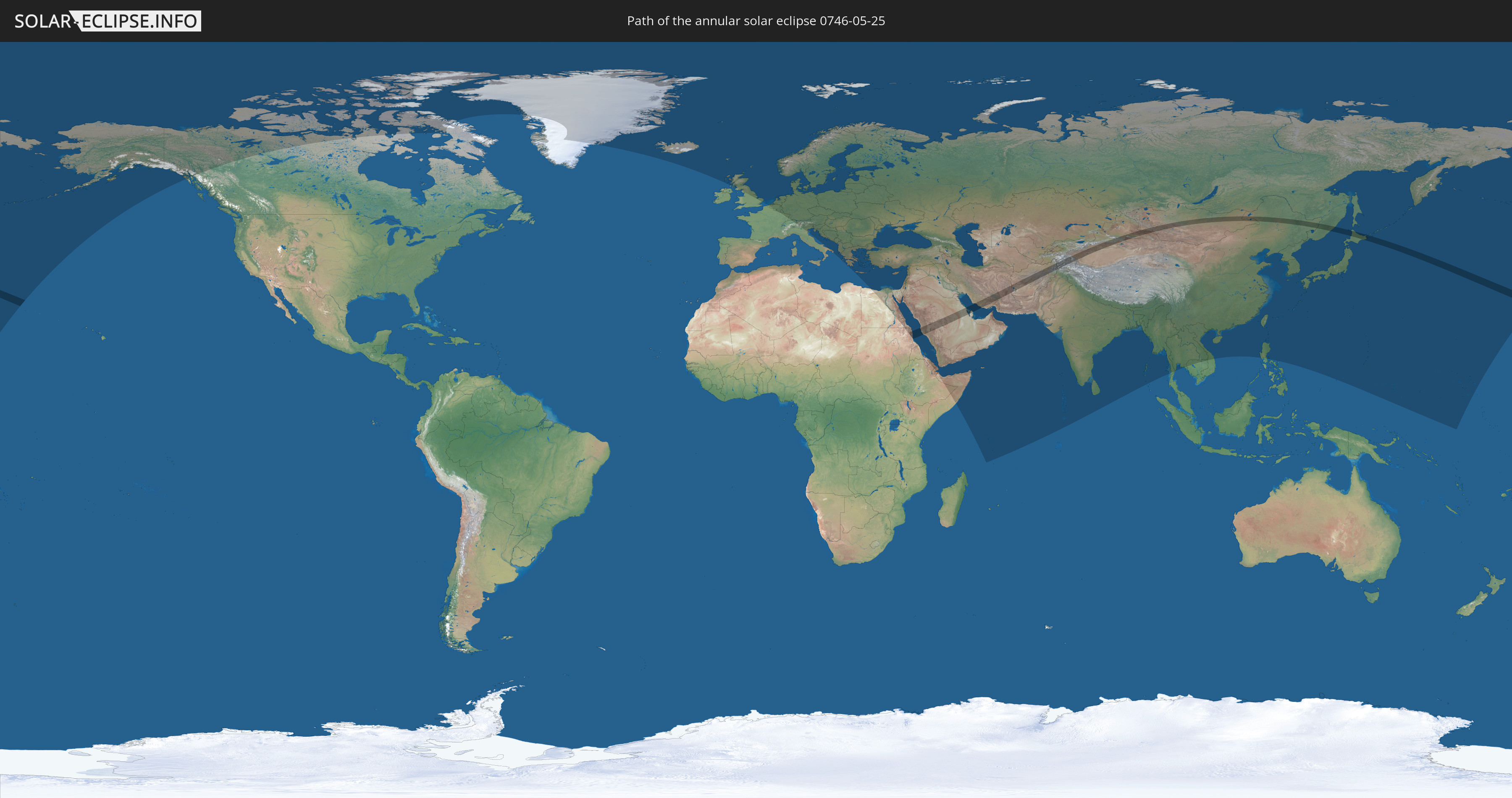
Die Sonnenfinsternis am 05/25/0746 kann man in 101 Ländern als partielle Sonnenfinsternis beobachten.
Der Finsternispfad verläuft durch 13 Länder. Nur in diesen Ländern ist sie als annular Sonnenfinsternis zu sehen.
In den folgenden Ländern ist die Sonnenfinsternis annular zu sehen
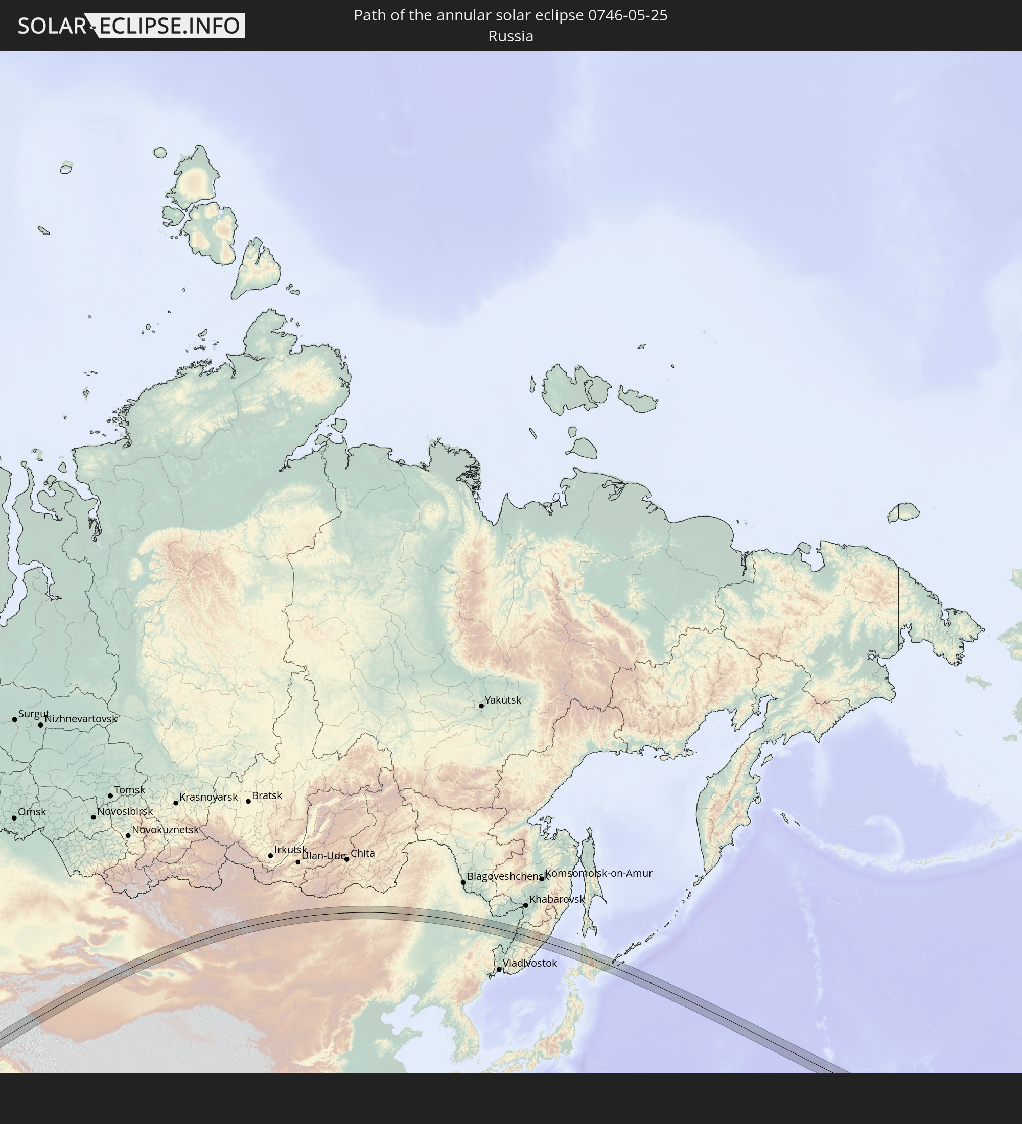 Russia
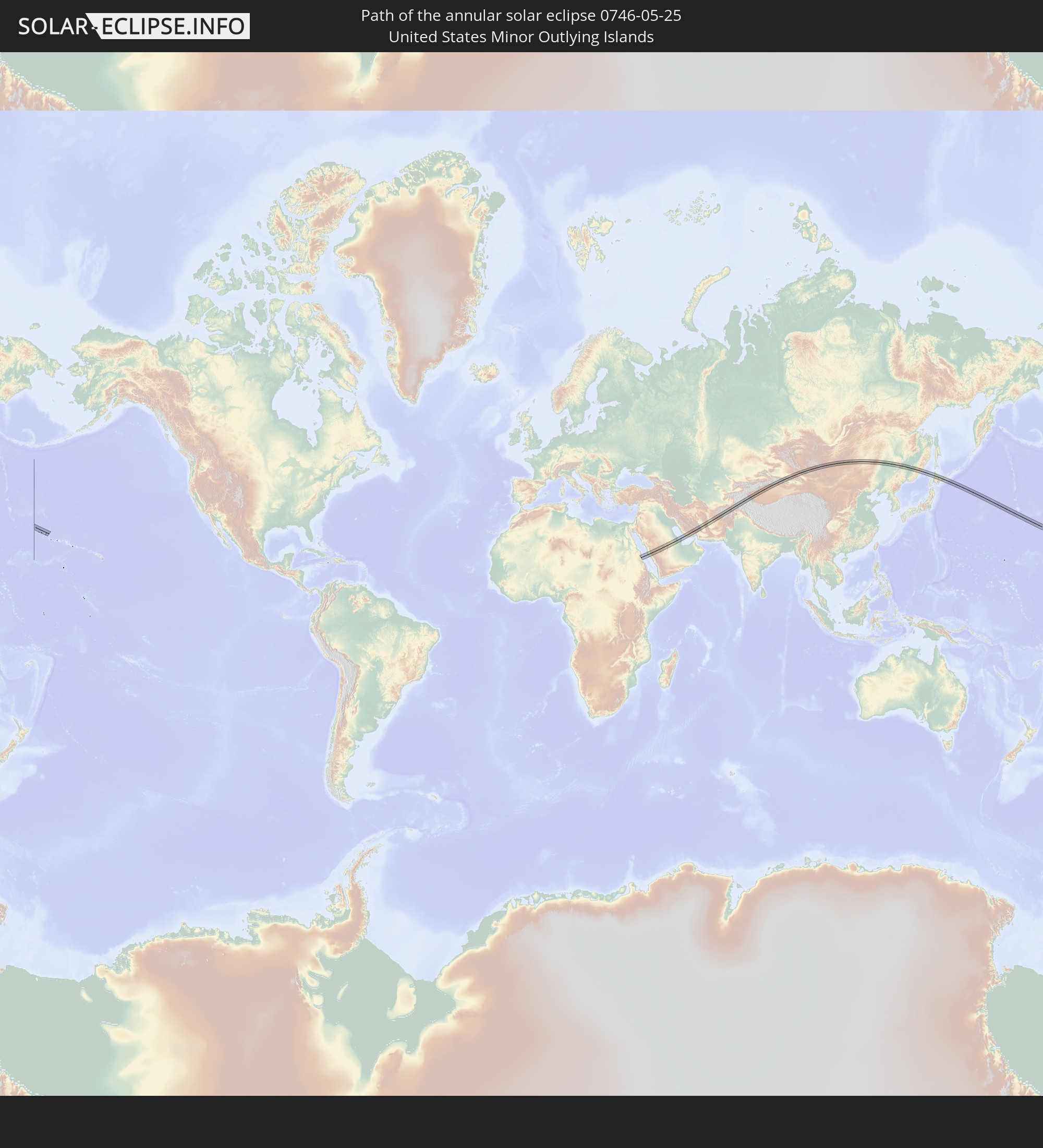 United States Minor Outlying Islands
 Sudan
Sudan
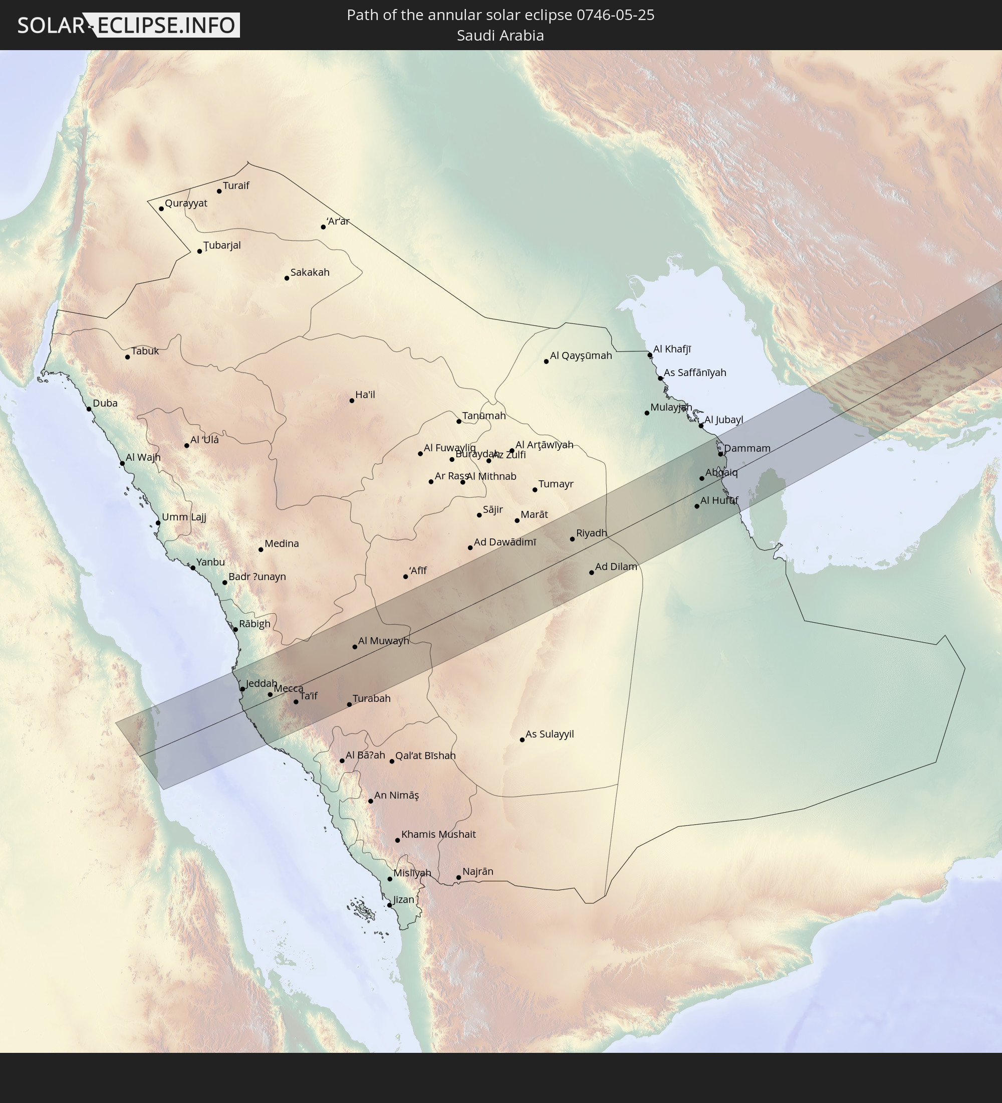 Saudi Arabia
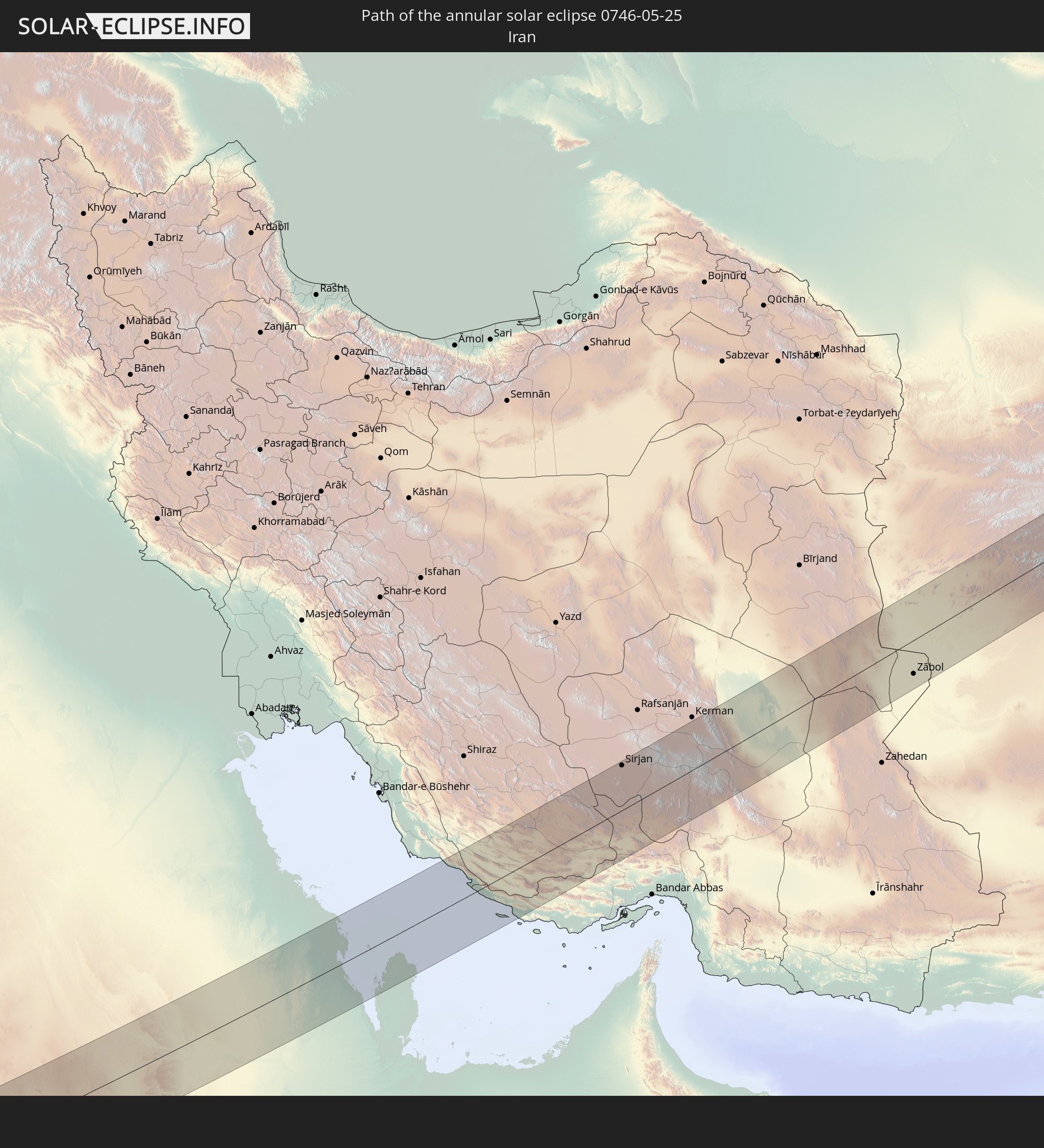 Iran
Iran
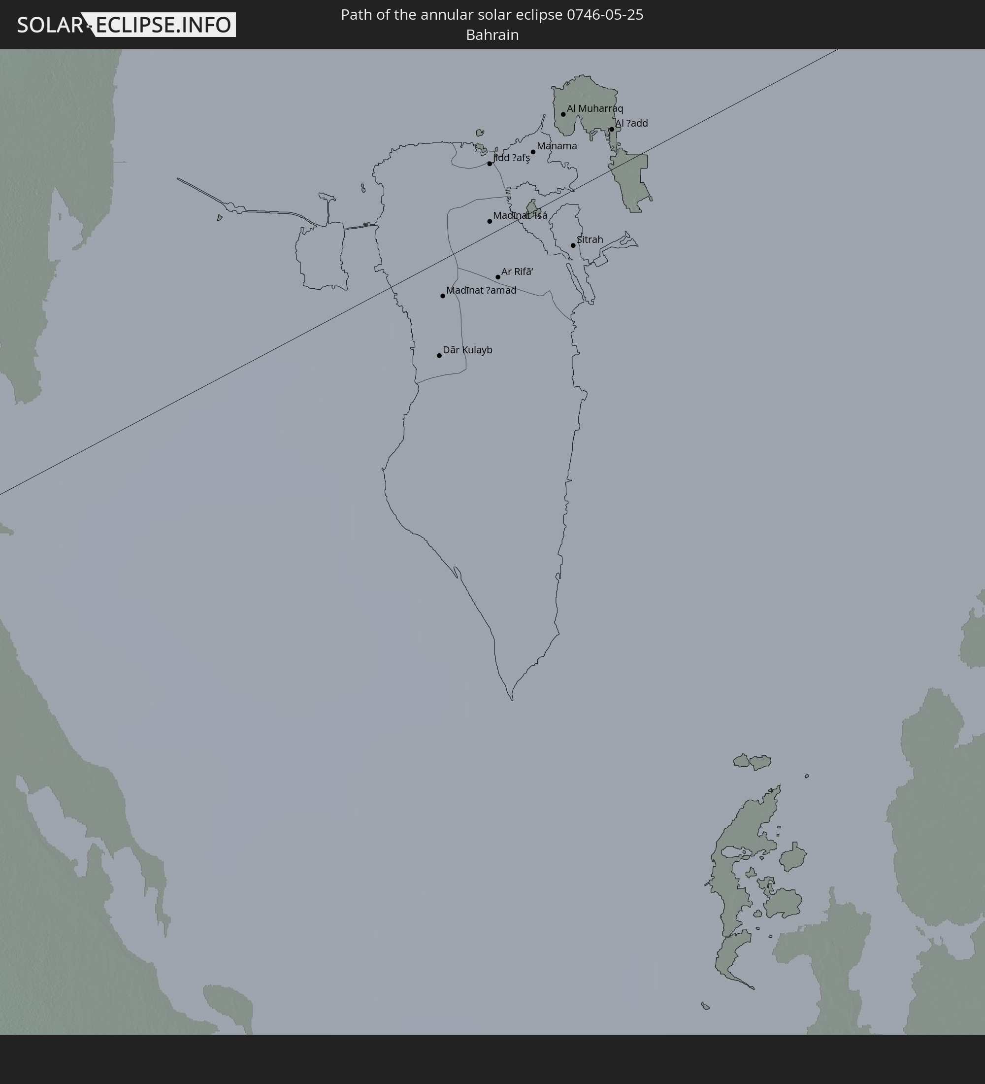 Bahrain
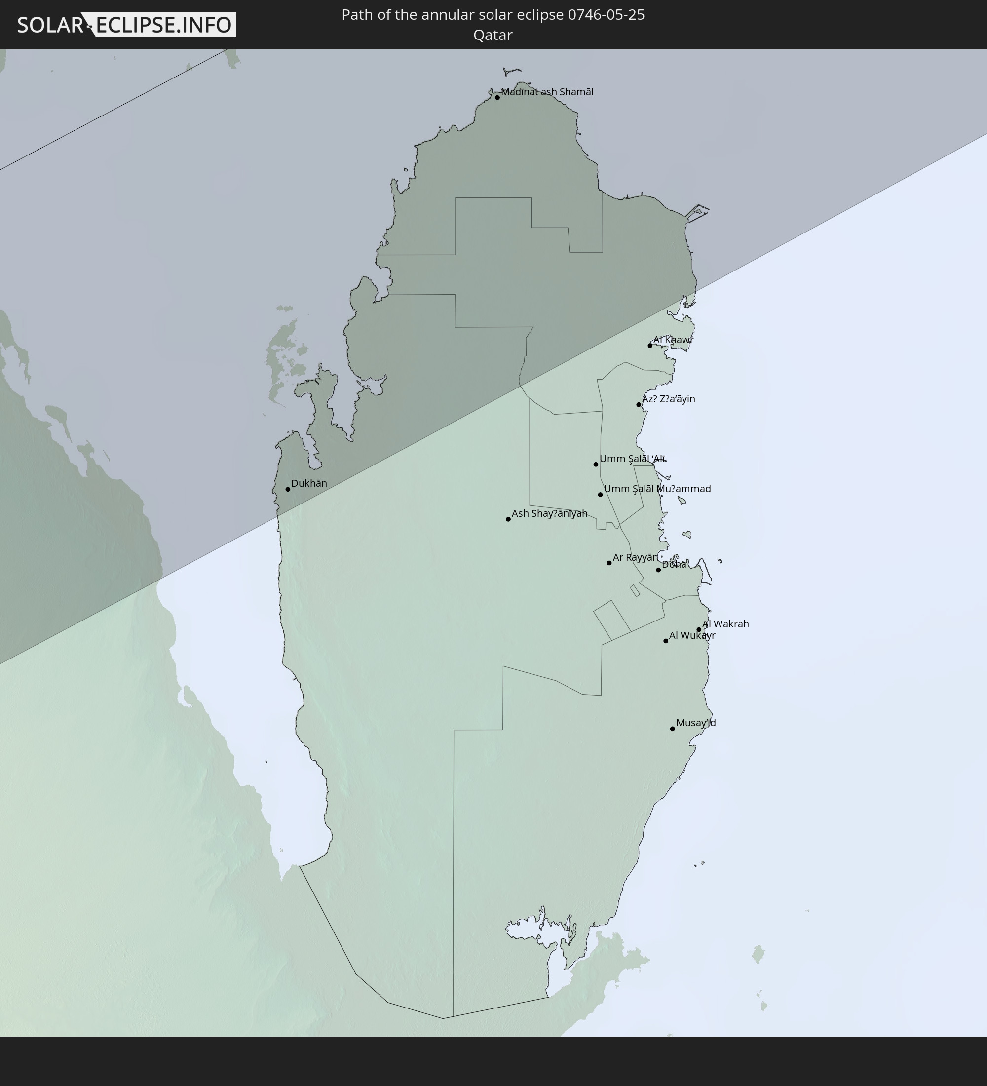 Qatar
Qatar
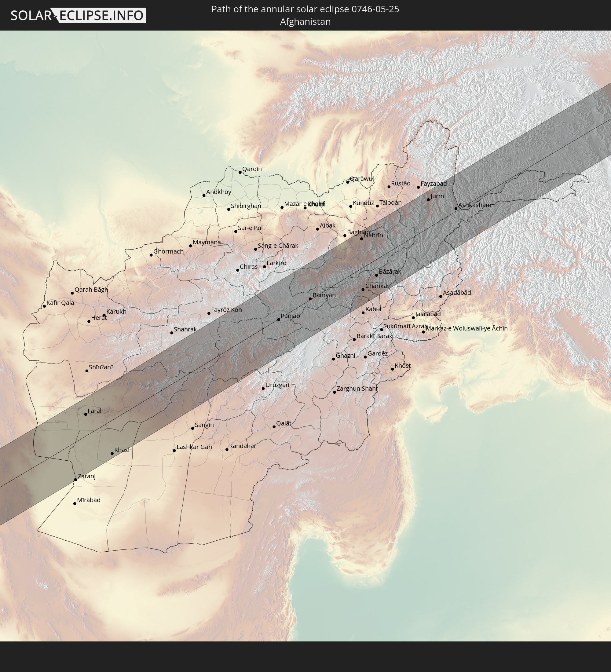 Afghanistan
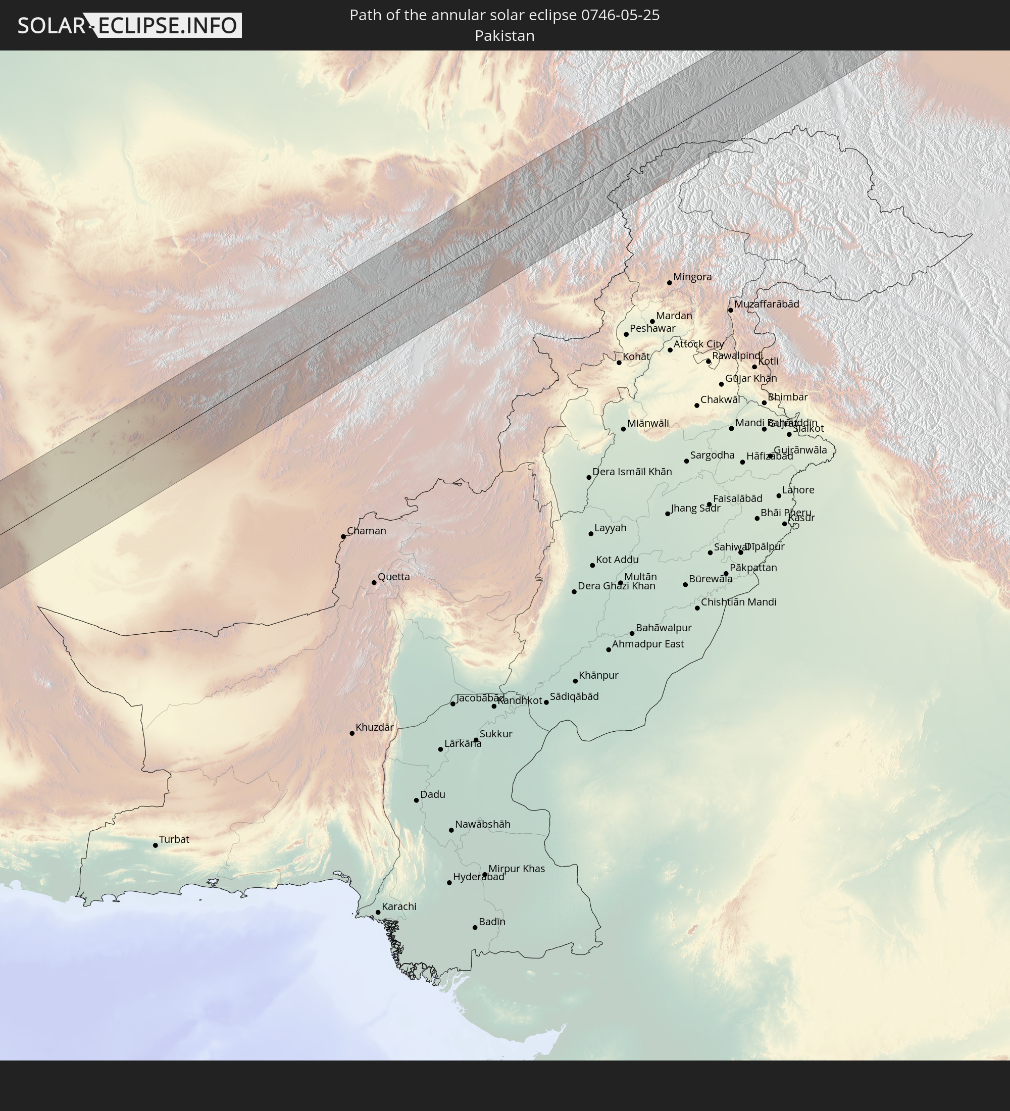 Pakistan
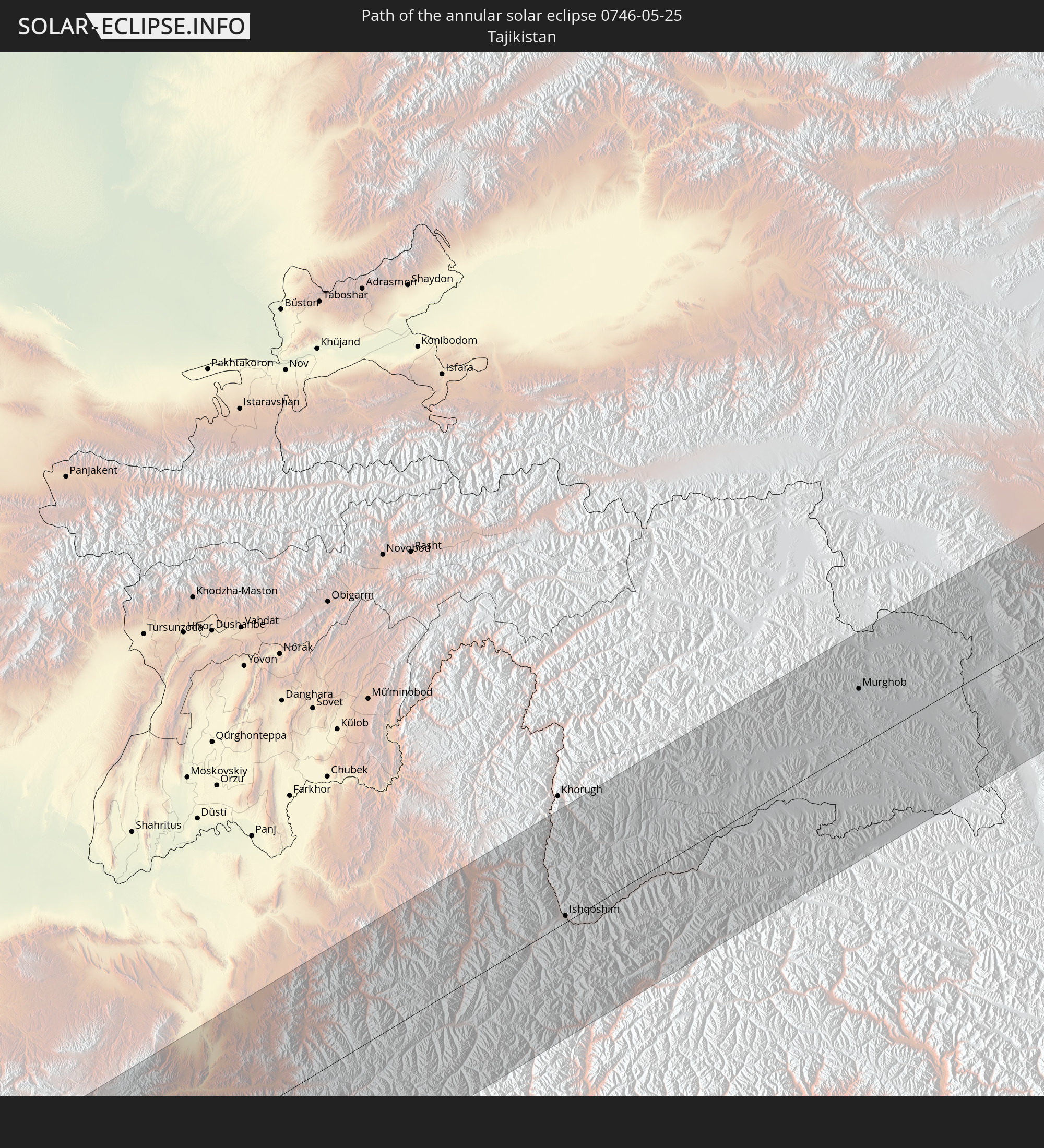 Tajikistan
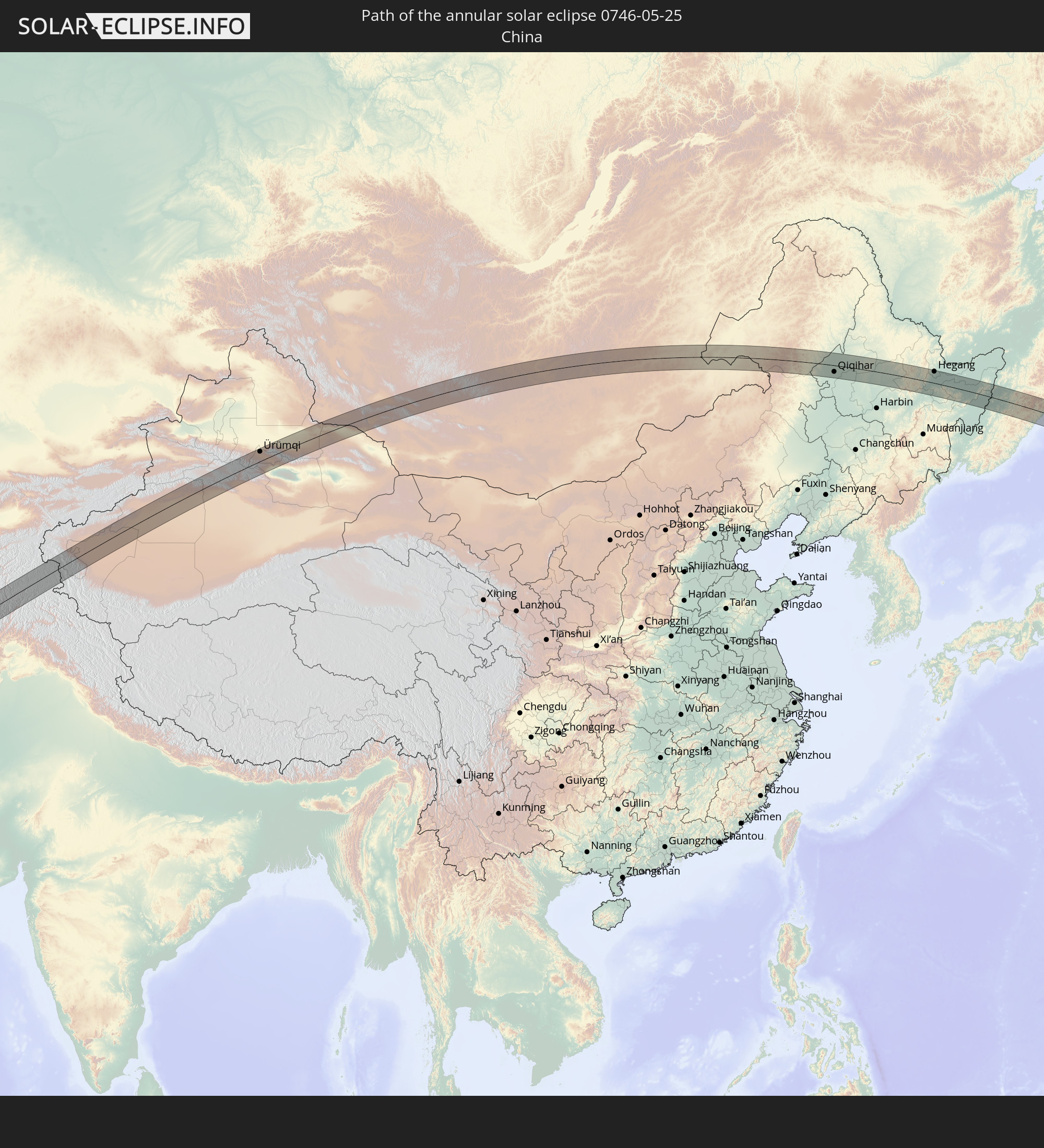 China
China
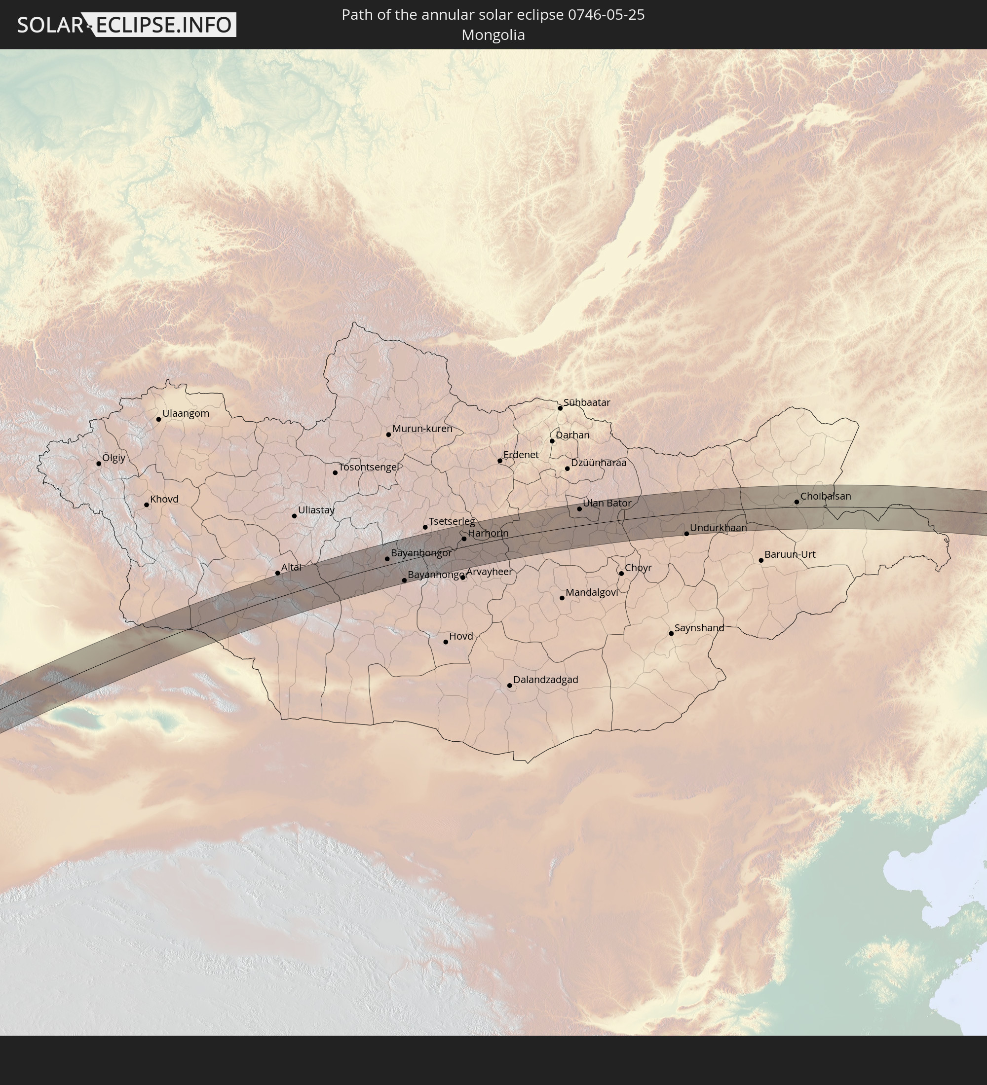 Mongolia
 Japan
Japan
In den folgenden Ländern ist die Sonnenfinsternis partiell zu sehen
 Russia
 United States
 United States Minor Outlying Islands
 Canada
 Greenland
 Iceland
 Svalbard and Jan Mayen
 United Kingdom
 Faroe Islands
 France
 Belgium
 Netherlands
 Norway
 Luxembourg
 Germany
 Switzerland
 Italy
Italy
 Denmark
 Liechtenstein
 Austria
 Sweden
 Czechia
 Slovenia
 Croatia
 Poland
 Bosnia and Herzegovina
 Hungary
 Slovakia
 Montenegro
 Serbia
 Albania
 Åland Islands
 Greece
 Romania
 Republic of Macedonia
 Finland
 Lithuania
 Latvia
 Estonia
 Sudan
Sudan
 Ukraine
 Bulgaria
 Belarus
 Egypt
Egypt
 Turkey
 Moldova
 Cyprus
 Ethiopia
 State of Palestine
 Israel
 Saudi Arabia
 Jordan
 Lebanon
 Syria
Syria
 Eritrea
 Iraq
Iraq
 Georgia
 Somalia
 Djibouti
 Yemen
Yemen
 Armenia
 Iran
Iran
 Azerbaijan
 Seychelles
 Kazakhstan
 Kuwait
 Bahrain
 Qatar
Qatar
 United Arab Emirates
 Oman
Oman
 Turkmenistan
 Uzbekistan
 Afghanistan
 Pakistan
 Tajikistan
 India
India
 Kyrgyzstan
 Maldives
 China
China
 Sri Lanka
 Nepal
Nepal
 Mongolia
 Bangladesh
 Bhutan
 Myanmar
 Thailand
 Laos
Laos
 Vietnam
 Cambodia
 Macau
Macau
 Hong Kong
 Taiwan
 Philippines
 Japan
Japan
 North Korea
 South Korea
 Federated States of Micronesia
 Guam
Guam
 Northern Mariana Islands
 Marshall Islands
 Nauru
Nauru
How will be the weather during the annular solar eclipse on 05/25/0746?
Where is the best place to see the annular solar eclipse of 05/25/0746?
The following maps show the average cloud coverage for the day of the annular solar eclipse.
With the help of these maps, it is possible to find the place along the eclipse path, which has the best
chance of a cloudless sky.
Nevertheless, you should consider local circumstances and inform about the weather of your chosen
observation site.
The data is provided by NASAs satellites
AQUA and TERRA.
The cloud maps are averaged over a period of 19 years (2000 - 2019).
Detailed country maps
 Russia
 United States Minor Outlying Islands
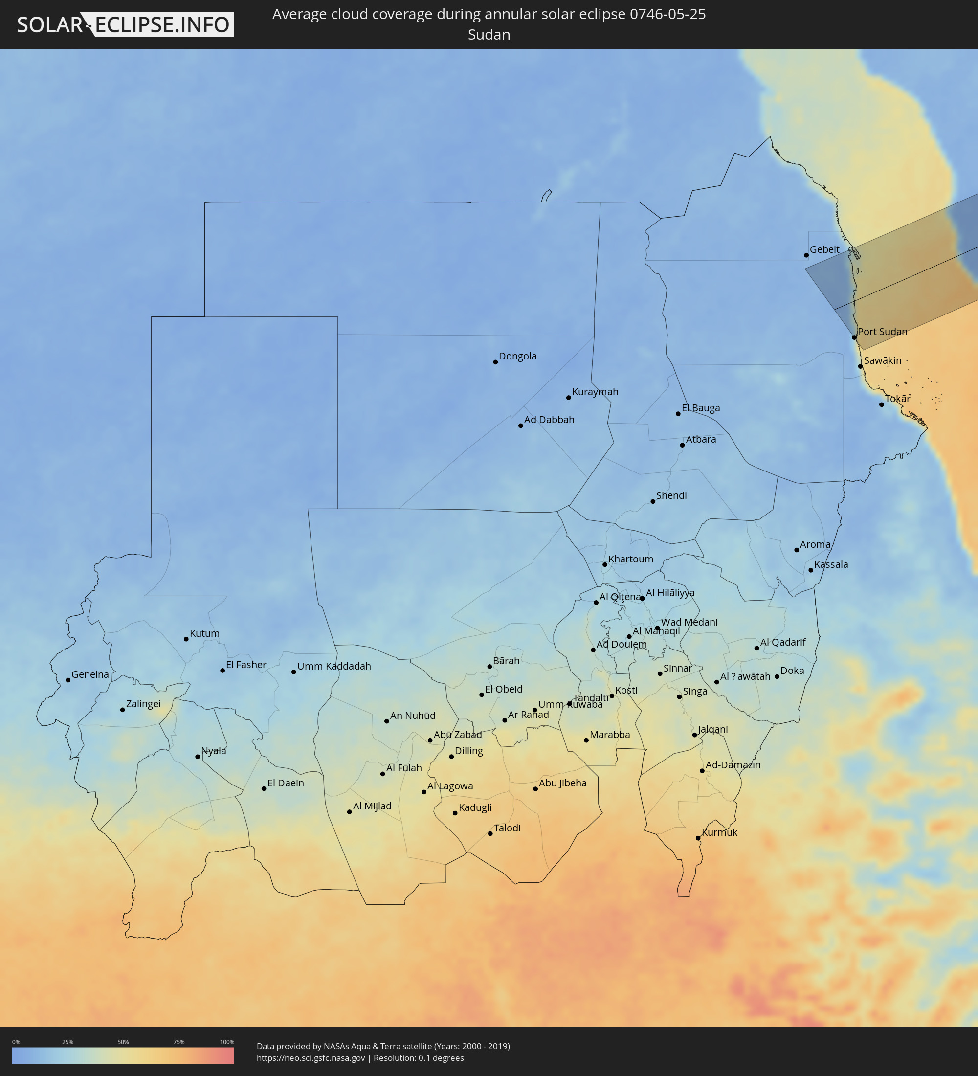 Sudan
Sudan
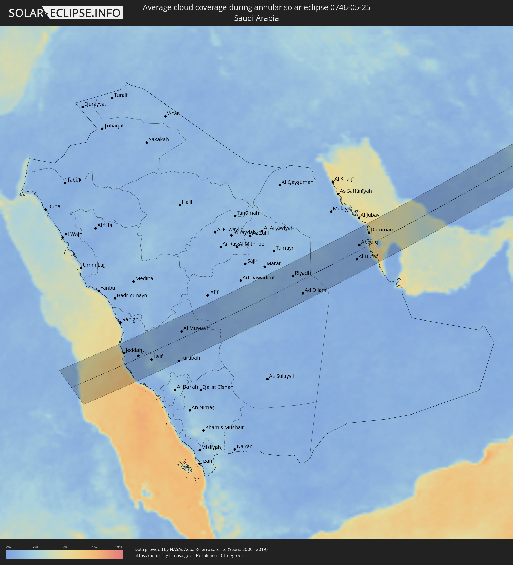 Saudi Arabia
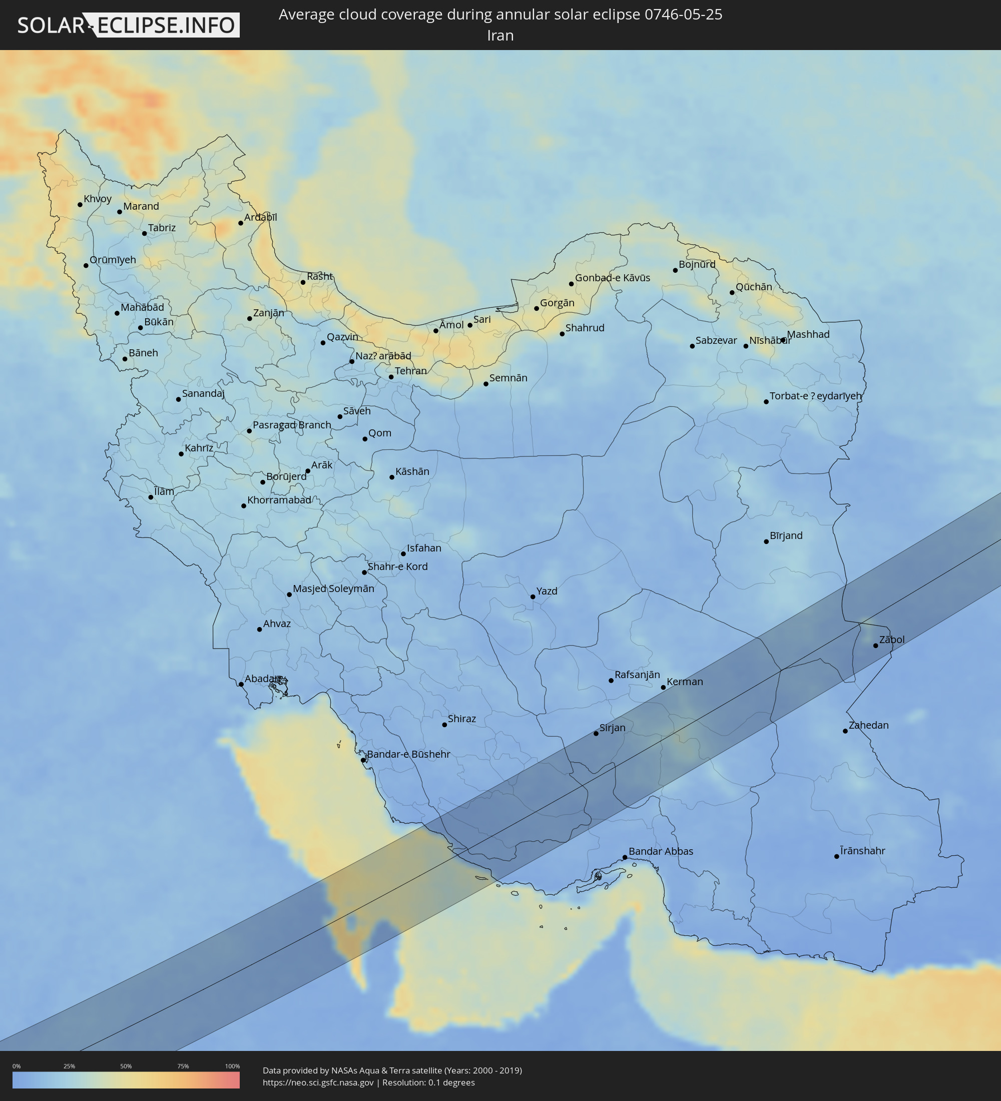 Iran
Iran
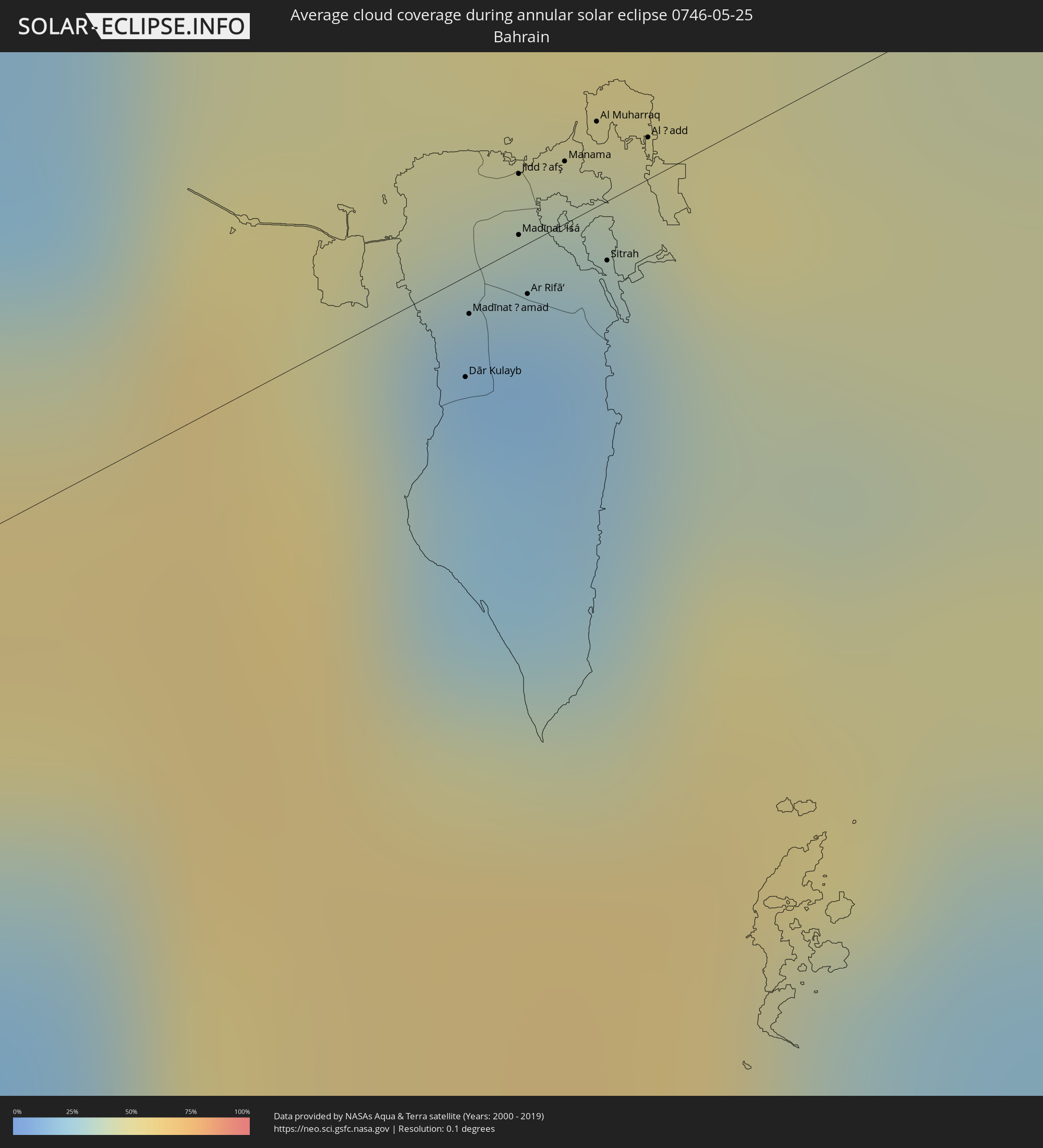 Bahrain
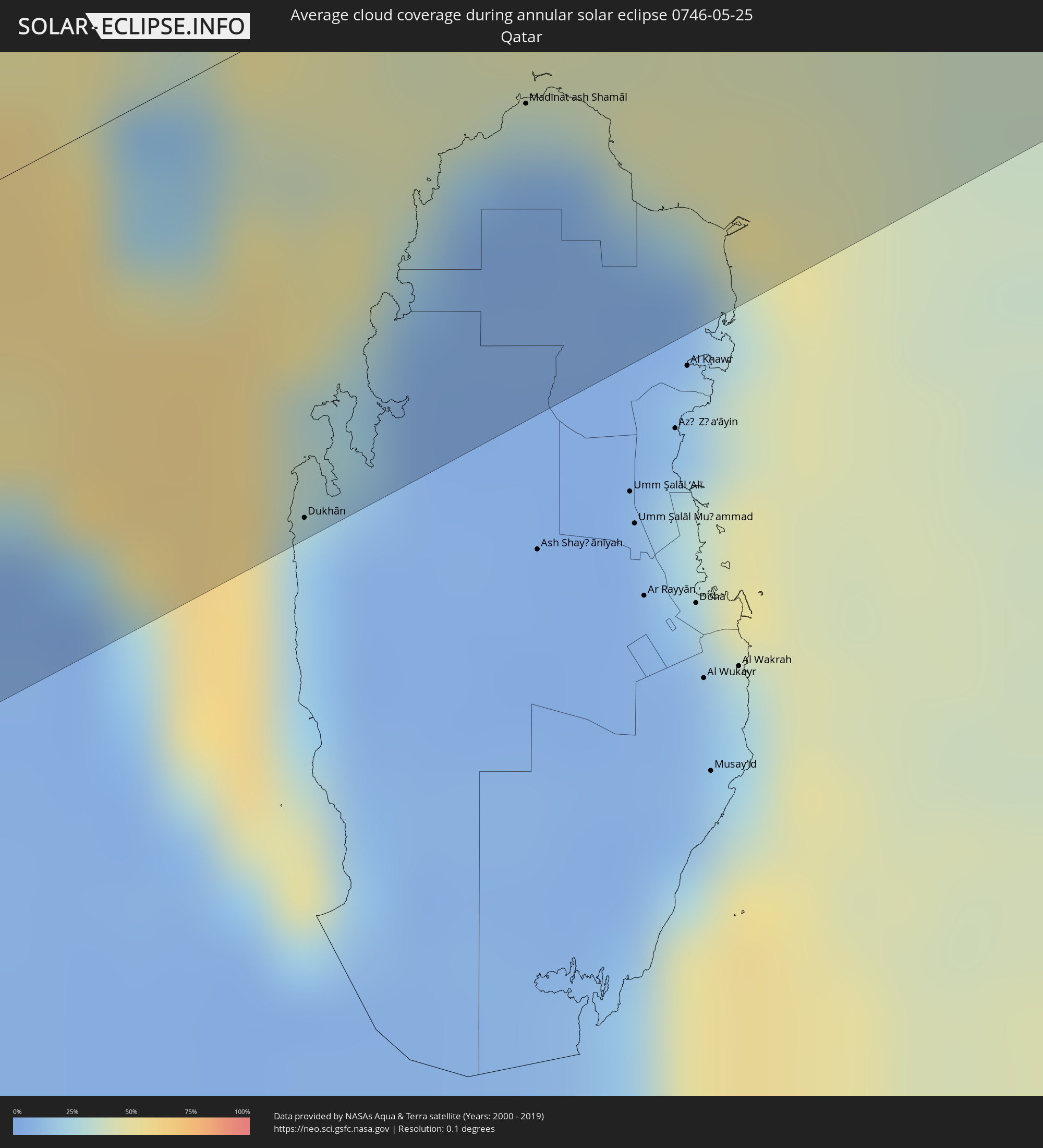 Qatar
Qatar
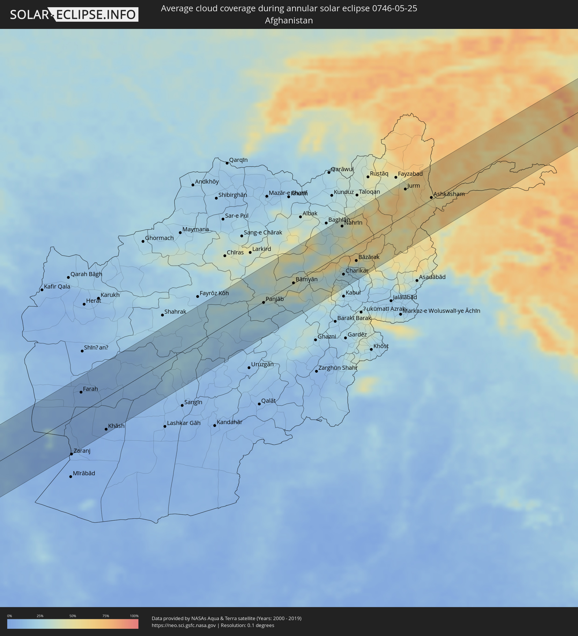 Afghanistan
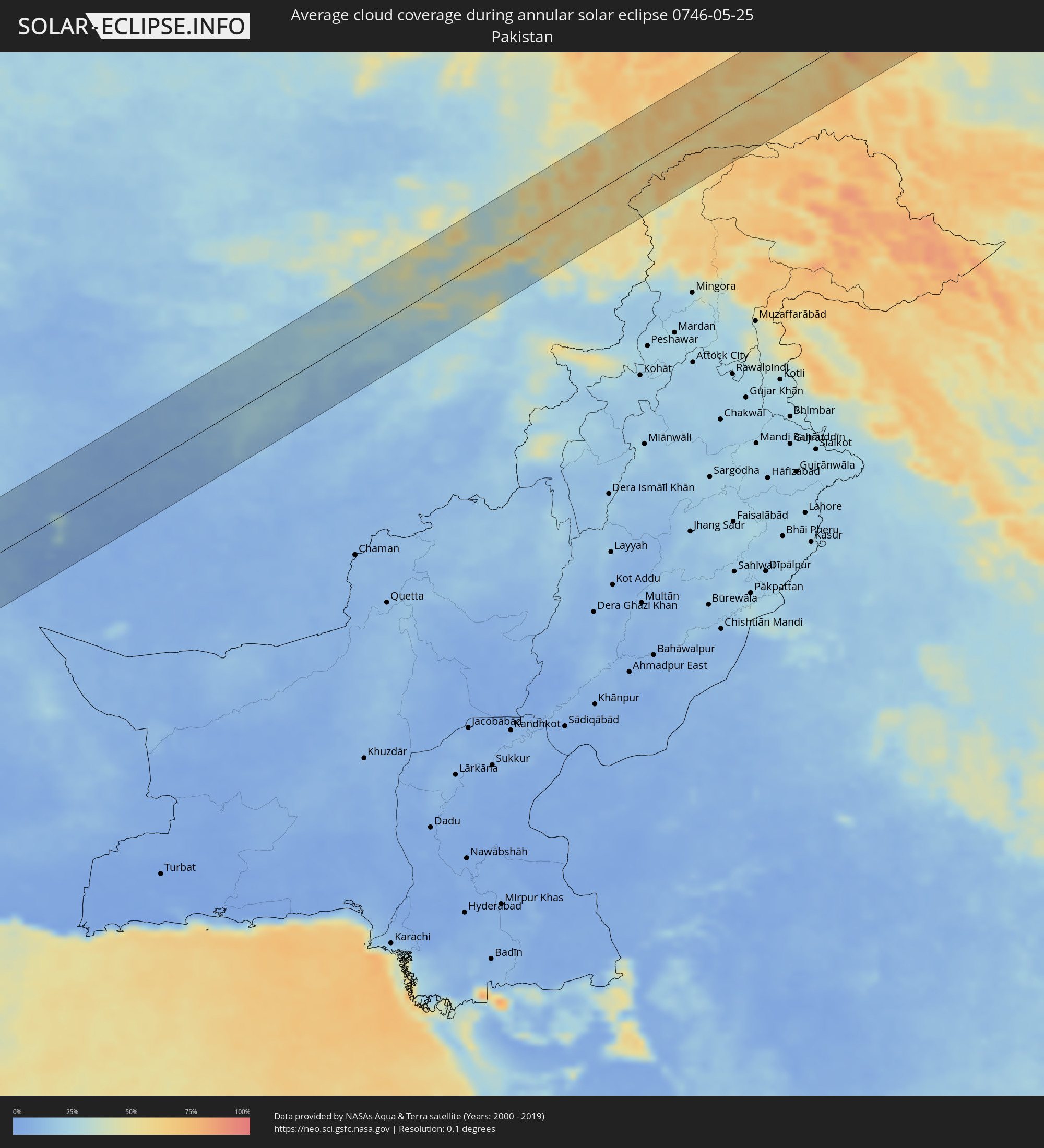 Pakistan
 Tajikistan
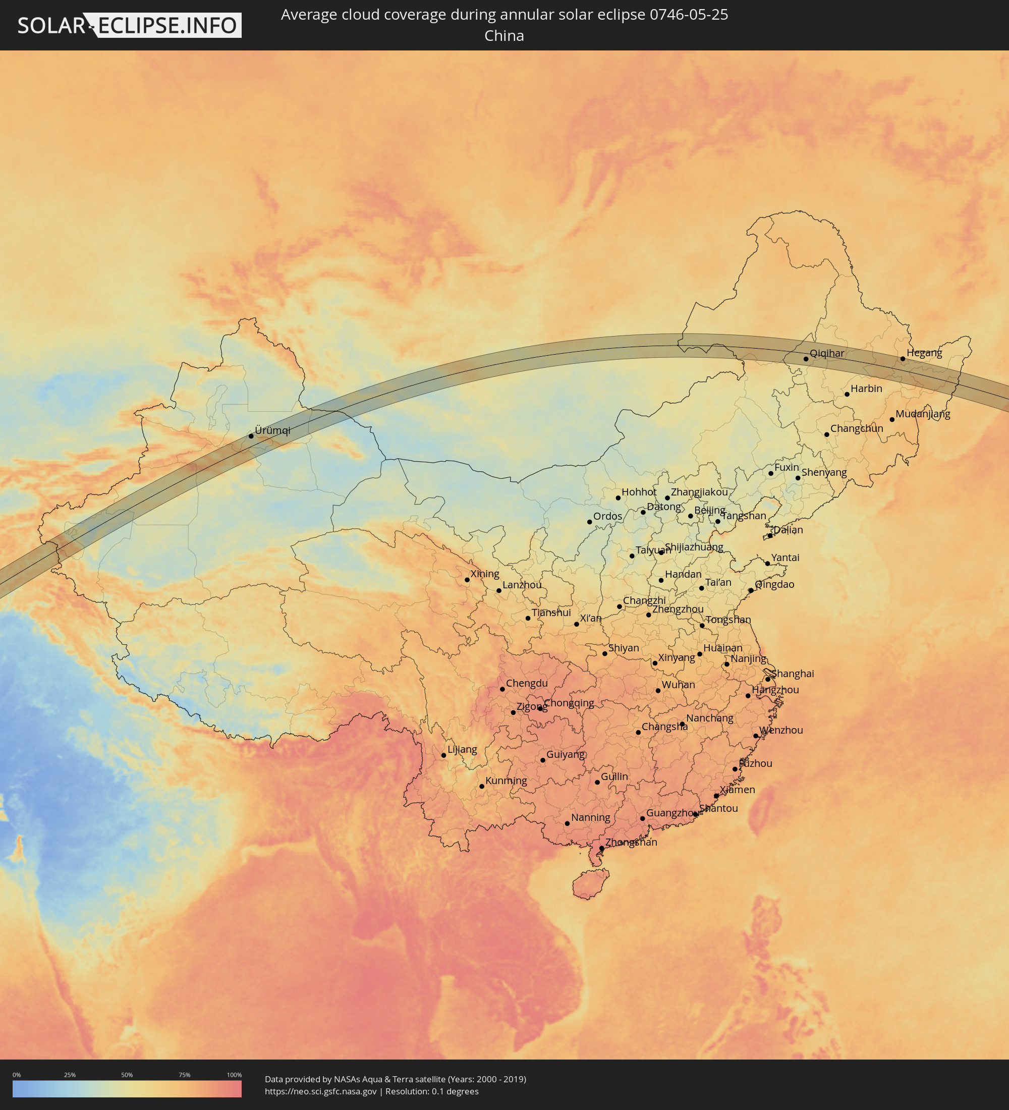 China
China
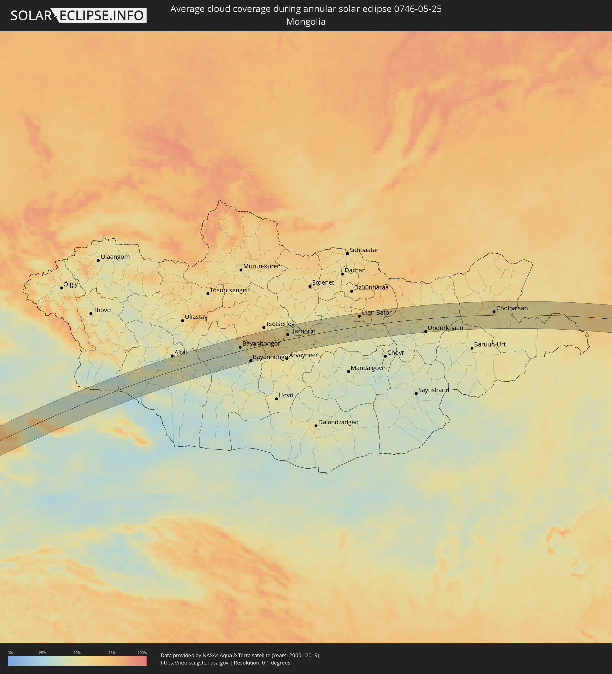 Mongolia
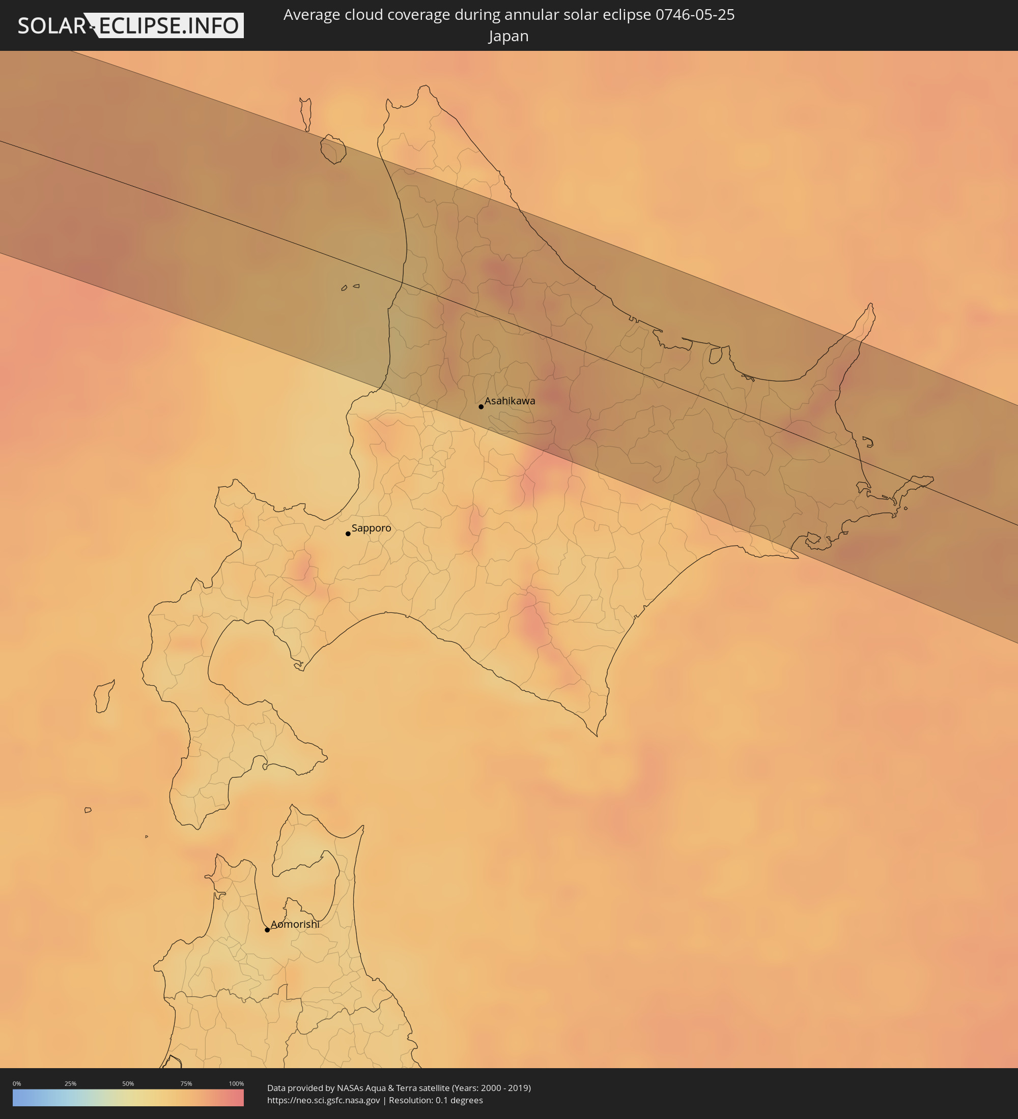 Japan
Japan
Cities inside the path of the eclipse
The following table shows all locations with a population of more than 5,000 inside the eclipse path. Cities which have more than 100,000 inhabitants are marked bold. A click at the locations opens a detailed map.
| City | Type | Eclipse duration | Local time of max. eclipse | Distance to central line | Ø Cloud coverage |
|
Port Sudan, Red Sea
|
annular | - | 05:03:36 UTC+02:10 | 68 km | 19% |
|
Jeddah, Makkah
|
annular | - | 06:01:33 UTC+03:06 | 46 km | 20% |
|
Al Jumūm, Makkah
|
annular | - | 06:01:28 UTC+03:06 | 33 km | 6% |
|
Mecca, Makkah
|
annular | - | 06:01:14 UTC+03:06 | 8 km | 7% |
|
Ash Shafā, Makkah
|
annular | - | 06:00:43 UTC+03:06 | 49 km | 14% |
|
Ta’if, Makkah
|
annular | - | 06:00:54 UTC+03:06 | 33 km | 20% |
|
Turabah, Makkah
|
annular | - | 06:00:30 UTC+03:06 | 91 km | 8% |
|
Riyadh, Ar Riyāḑ
|
annular | - | 06:03:30 UTC+03:06 | 31 km | 10% |
|
Ad Dilam, Ar Riyāḑ
|
annular | - | 06:02:38 UTC+03:06 | 58 km | 7% |
|
Al Hufūf, Eastern Province
|
annular | - | 06:04:13 UTC+03:06 | 33 km | 6% |
|
Al Qurayn, Eastern Province
|
annular | - | 06:04:22 UTC+03:06 | 23 km | 6% |
|
Al Baţţālīyah, Eastern Province
|
annular | - | 06:04:18 UTC+03:06 | 29 km | 6% |
|
Al Munayzilah, Eastern Province
|
annular | - | 06:04:14 UTC+03:06 | 36 km | 6% |
|
Abqaiq, Eastern Province
|
annular | - | 06:04:57 UTC+03:06 | 18 km | 5% |
|
Aţ Ţaraf, Eastern Province
|
annular | - | 06:04:13 UTC+03:06 | 40 km | 6% |
|
Umm as Sāhik, Eastern Province
|
annular | - | 06:05:52 UTC+03:06 | 78 km | 9% |
|
Tārūt, Eastern Province
|
annular | - | 06:05:46 UTC+03:06 | 64 km | 16% |
|
Raḩīmah, Eastern Province
|
annular | - | 06:05:57 UTC+03:06 | 76 km | 46% |
|
Dammam, Eastern Province
|
annular | - | 06:05:36 UTC+03:06 | 47 km | 8% |
|
Khobar, Eastern Province
|
annular | - | 06:05:24 UTC+03:06 | 27 km | 25% |
|
Dār Kulayb, Southern Governorate
|
annular | - | 06:24:24 UTC+03:26 | 7 km | 23% |
|
Madīnat Ḩamad, Central Governorate
|
annular | - | 06:24:27 UTC+03:26 | 3 km | 23% |
|
Jidd Ḩafş, Manama
|
annular | - | 06:24:36 UTC+03:26 | 5 km | 18% |
|
Madīnat ‘Īsá, Southern Governorate
|
annular | - | 06:24:32 UTC+03:26 | 1 km | 18% |
|
Ar Rifā‘, Southern Governorate
|
annular | - | 06:24:29 UTC+03:26 | 4 km | 21% |
|
Manama, Manama
|
annular | - | 06:24:36 UTC+03:26 | 5 km | 19% |
|
Al Muharraq, Muharraq
|
annular | - | 06:24:39 UTC+03:26 | 6 km | 35% |
|
Sitrah, Manama
|
annular | - | 06:24:31 UTC+03:26 | 4 km | 19% |
|
Al Ḩadd, Muharraq
|
annular | - | 06:24:38 UTC+03:26 | 3 km | 40% |
|
Dukhān, Baladīyat ar Rayyān
|
annular | - | 06:23:35 UTC+03:26 | 84 km | 19% |
|
Madīnat ash Shamāl, Madīnat ash Shamāl
|
annular | - | 06:24:30 UTC+03:26 | 34 km | 9% |
|
Gerāsh, Fars
|
annular | - | 06:26:31 UTC+03:25 | 23 km | 5% |
|
Dārāb, Fars
|
annular | - | 06:28:07 UTC+03:25 | 63 km | 6% |
|
Sirjan, Kerman
|
annular | - | 06:29:22 UTC+03:25 | 76 km | 9% |
|
Bardsīr, Kerman
|
annular | - | 06:30:18 UTC+03:25 | 78 km | 16% |
|
Zābol, Sistan and Baluchestan
|
annular | - | 06:33:49 UTC+03:25 | 55 km | 6% |
|
Farah, Farah
|
annular | - | 07:10:32 UTC+04:00 | 43 km | 6% |
|
Khāsh, Nimroz
|
annular | - | 07:09:32 UTC+04:00 | 70 km | 5% |
|
Nīlī, Daykundi
|
annular | - | 07:15:09 UTC+04:00 | 23 km | 19% |
|
Panjāb, Bamyan
|
annular | - | 07:16:54 UTC+04:00 | 2 km | 23% |
|
Bāmyān, Bamyan
|
annular | - | 07:18:14 UTC+04:00 | 1 km | 36% |
|
Pul-e Khumrī, Baghlan
|
annular | - | 07:20:52 UTC+04:00 | 65 km | 29% |
|
Mīr Bachah Kōṯ, Kabul
|
annular | - | 07:19:09 UTC+04:00 | 67 km | 29% |
|
Nahrīn, Baghlan
|
annular | - | 07:21:26 UTC+04:00 | 57 km | 33% |
|
Charikar, Parwan
|
annular | - | 07:19:39 UTC+04:00 | 45 km | 25% |
|
Jabal os Saraj, Parwan
|
annular | - | 07:19:53 UTC+04:00 | 38 km | 25% |
|
Sidqābād, Kapisa
|
annular | - | 07:19:49 UTC+04:00 | 52 km | 24% |
|
Bāzārak, Panjshir
|
annular | - | 07:20:27 UTC+04:00 | 32 km | 32% |
|
Farkhār, Takhar
|
annular | - | 07:22:56 UTC+04:00 | 71 km | 44% |
|
Jurm, Badakhshan
|
annular | - | 07:24:18 UTC+04:00 | 53 km | 54% |
|
Ashkāsham, Badakhshan
|
annular | - | 07:24:39 UTC+04:00 | 4 km | 52% |
|
Ishqoshim, Gorno-Badakhshan
|
annular | - | 07:59:59 UTC+04:35 | 4 km | 54% |
|
Khandūd, Badakhshan
|
annular | - | 07:25:52 UTC+04:00 | 7 km | 52% |
|
Murghob, Gorno-Badakhshan
|
annular | - | 08:04:54 UTC+04:35 | 35 km | 54% |
|
Aksu, Xinjiang Uyghur Autonomous Region
|
annular | - | 11:42:38 UTC+08:00 | 56 km | 48% |
|
Aral, Xinjiang Uyghur Autonomous Region
|
annular | - | 11:42:53 UTC+08:00 | 47 km | 51% |
|
Kuqa, Xinjiang Uyghur Autonomous Region
|
annular | - | 11:47:18 UTC+08:00 | 5 km | 52% |
|
Ürümqi, Xinjiang Uyghur Autonomous Region
|
annular | - | 11:57:55 UTC+08:00 | 44 km | 43% |
|
Bayanhongor, Bayanhongor
|
annular | - | 11:32:01 UTC+07:07 | 15 km | 42% |
|
Bayanhongor, Bayanhongor
|
annular | - | 11:32:46 UTC+07:07 | 53 km | 41% |
|
Kharkhorin, Övörhangay
|
annular | - | 11:37:45 UTC+07:07 | 19 km | 56% |
|
Harhorin, Övörhangay
|
annular | - | 11:37:46 UTC+07:07 | 19 km | 56% |
|
Ulan Bator, Ulaanbaatar
|
annular | - | 11:46:19 UTC+07:07 | 42 km | 57% |
|
Зуунмод, Central Aimak
|
annular | - | 11:46:22 UTC+07:07 | 19 km | 50% |
|
Dzuunmod, Central Aimak
|
annular | - | 11:46:22 UTC+07:07 | 19 km | 50% |
|
Undurkhaan, Hentiy
|
annular | - | 11:53:51 UTC+07:07 | 56 km | 46% |
|
Choibalsan, East Aimak
|
annular | - | 12:01:43 UTC+07:07 | 12 km | 50% |
|
Zhalantun, Inner Mongolia
|
annular | - | 13:10:01 UTC+08:00 | 33 km | 63% |
|
Longjiang, Heilongjiang
|
annular | - | 13:11:19 UTC+08:00 | 39 km | 56% |
|
Hulan Ergi, Heilongjiang
|
annular | - | 13:12:16 UTC+08:00 | 49 km | 55% |
|
Qiqihar, Heilongjiang
|
annular | - | 13:12:46 UTC+08:00 | 30 km | 56% |
|
Fuyu, Heilongjiang
|
annular | - | 13:13:18 UTC+08:00 | 25 km | 58% |
|
Baiquan, Heilongjiang
|
annular | - | 13:16:22 UTC+08:00 | 22 km | 61% |
|
Wangkui, Heilongjiang
|
annular | - | 13:17:45 UTC+08:00 | 58 km | 58% |
|
Hailun, Heilongjiang
|
annular | - | 13:18:01 UTC+08:00 | 16 km | 58% |
|
Tieli, Heilongjiang
|
annular | - | 13:20:22 UTC+08:00 | 21 km | 56% |
|
Lianhe, Heilongjiang
|
annular | - | 13:22:17 UTC+08:00 | 14 km | 66% |
|
Hegang, Heilongjiang
|
annular | - | 13:23:45 UTC+08:00 | 54 km | 66% |
|
Jiamusi, Heilongjiang
|
annular | - | 13:24:23 UTC+08:00 | 6 km | 66% |
|
Lingdong, Heilongjiang
|
annular | - | 13:25:59 UTC+08:00 | 17 km | 71% |
|
Shuangyashan, Heilongjiang
|
annular | - | 13:25:55 UTC+08:00 | 9 km | 70% |
|
Baoshan, Heilongjiang
|
annular | - | 13:26:27 UTC+08:00 | 13 km | 69% |
|
Dal’nerechensk, Primorskiy
|
annular | - | 14:18:22 UTC+08:47 | 36 km | 62% |
|
Luchegorsk, Primorskiy
|
annular | - | 14:18:22 UTC+08:47 | 31 km | 61% |
|
Rumoi, Hokkaido
|
annular | - | 14:44:33 UTC+09:00 | 58 km | 65% |
|
Asahikawa, Hokkaido
|
annular | - | 14:45:40 UTC+09:00 | 55 km | 67% |
|
Nayoro, Hokkaido
|
annular | - | 14:44:56 UTC+09:00 | 9 km | 75% |
|
Kamikawa, Hokkaido
|
annular | - | 14:46:03 UTC+09:00 | 36 km | 82% |
|
Mombetsu, Hokkaido
|
annular | - | 14:45:58 UTC+09:00 | 34 km | 76% |
|
Kitami, Hokkaido
|
annular | - | 14:47:24 UTC+09:00 | 7 km | 74% |
|
Bihoro, Hokkaido
|
annular | - | 14:47:37 UTC+09:00 | 1 km | 75% |
|
Abashiri, Hokkaido
|
annular | - | 14:47:30 UTC+09:00 | 27 km | 73% |
|
Shibetsu, Hokkaido
|
annular | - | 14:48:59 UTC+09:00 | 15 km | 75% |
|
Nemuro, Hokkaido
|
annular | - | 14:49:58 UTC+09:00 | 6 km | 80% |