Total solar eclipse of 08/05/0761
| Day of week: | Saturday |
| Maximum duration of eclipse: | 04m38s |
| Maximum width of eclipse path: | 183 km |
| Saros cycle: | 96 |
| Coverage: | 100% |
| Magnitude: | 1.0548 |
| Gamma: | 0.1459 |
Wo kann man die Sonnenfinsternis vom 08/05/0761 sehen?
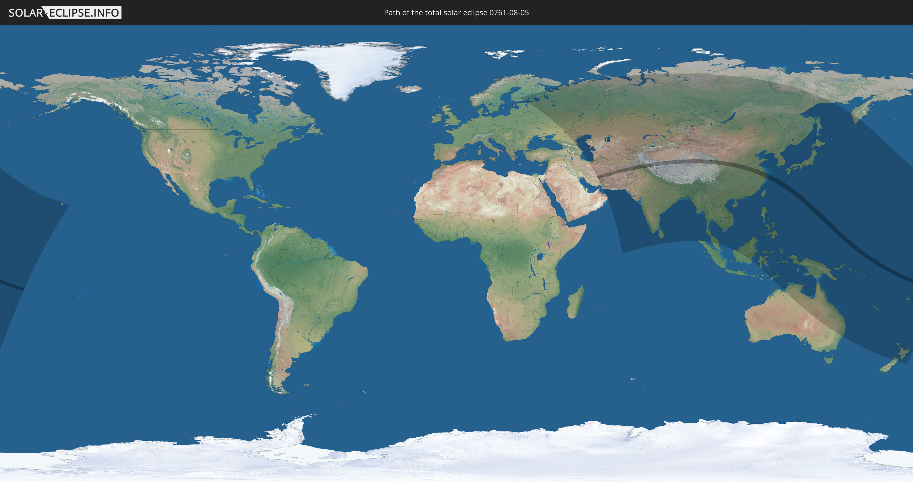
Die Sonnenfinsternis am 08/05/0761 kann man in 59 Ländern als partielle Sonnenfinsternis beobachten.
Der Finsternispfad verläuft durch 11 Länder. Nur in diesen Ländern ist sie als total Sonnenfinsternis zu sehen.
In den folgenden Ländern ist die Sonnenfinsternis total zu sehen
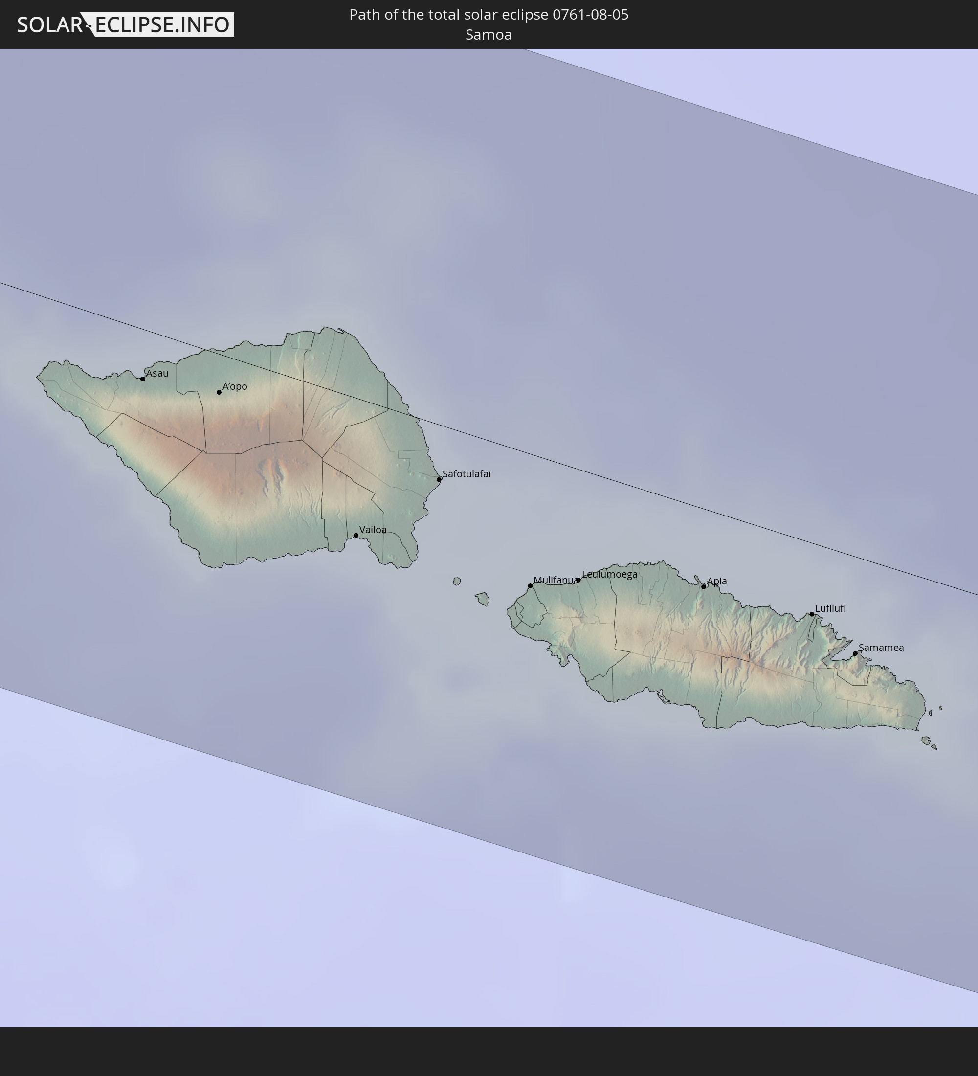 Samoa
Samoa
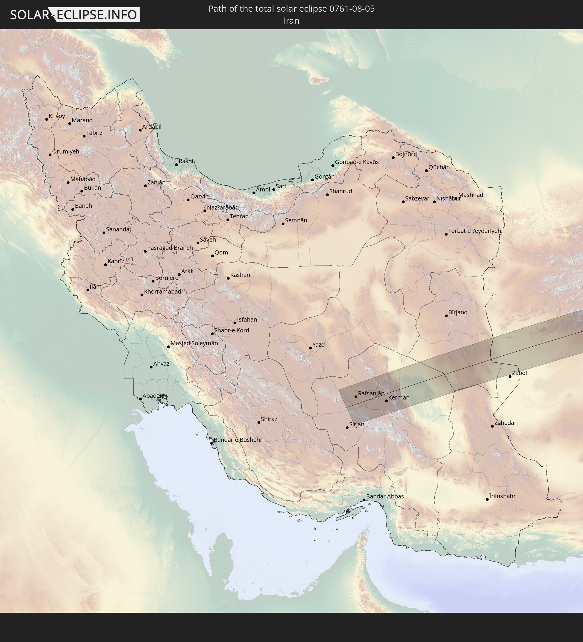 Iran
Iran
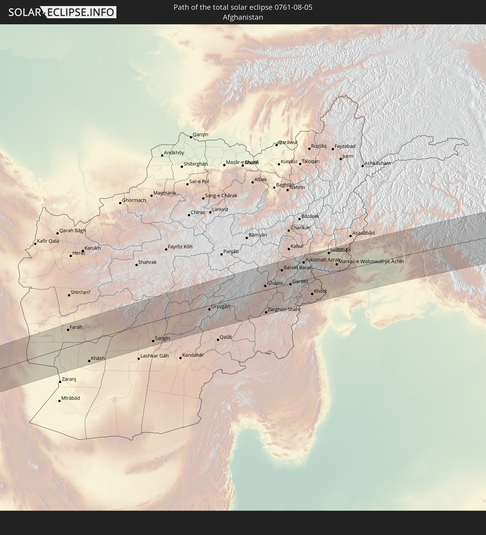 Afghanistan
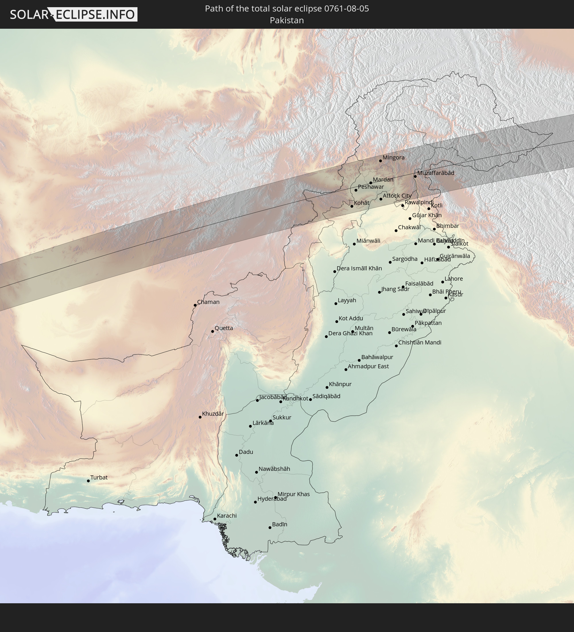 Pakistan
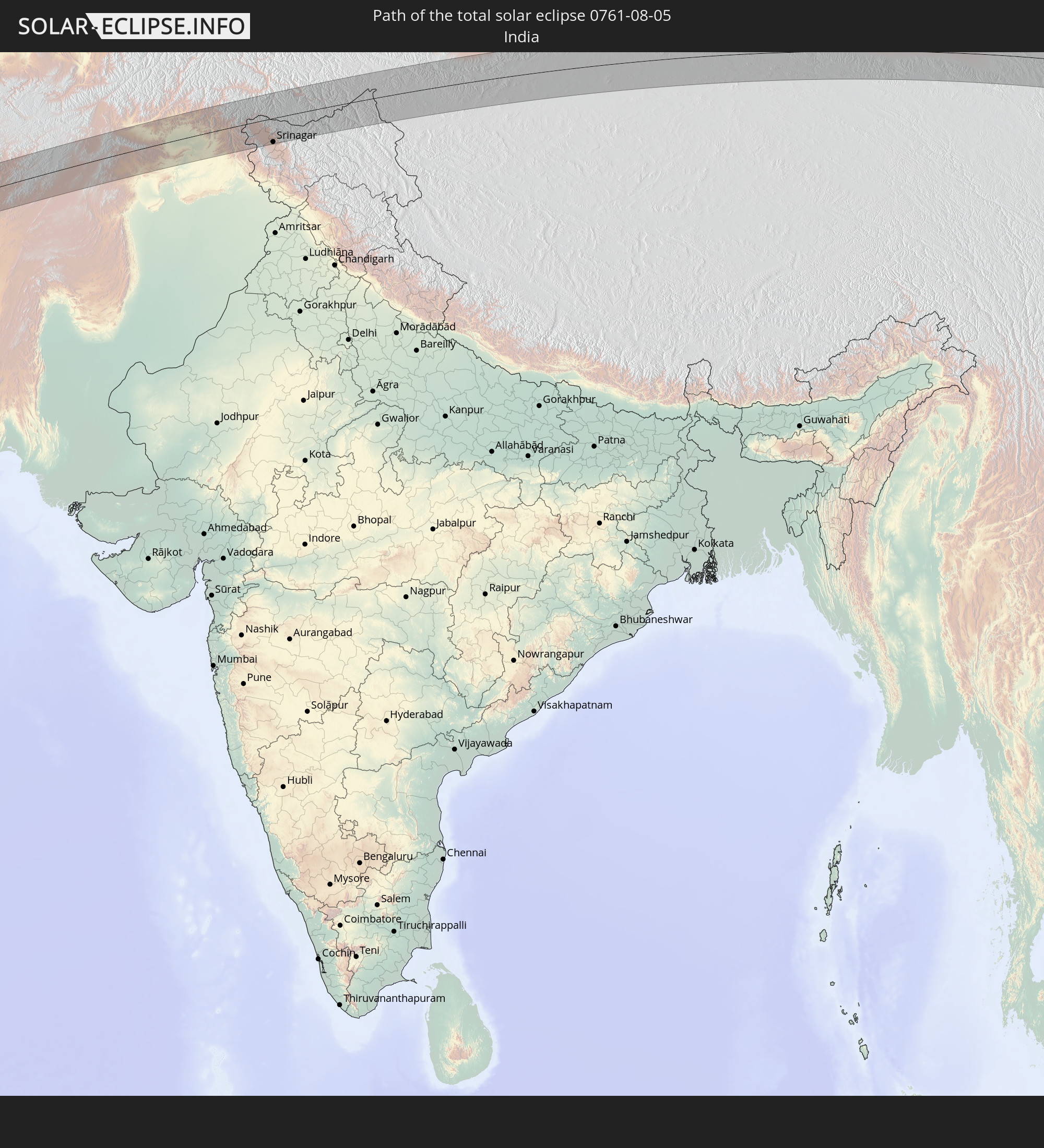 India
India
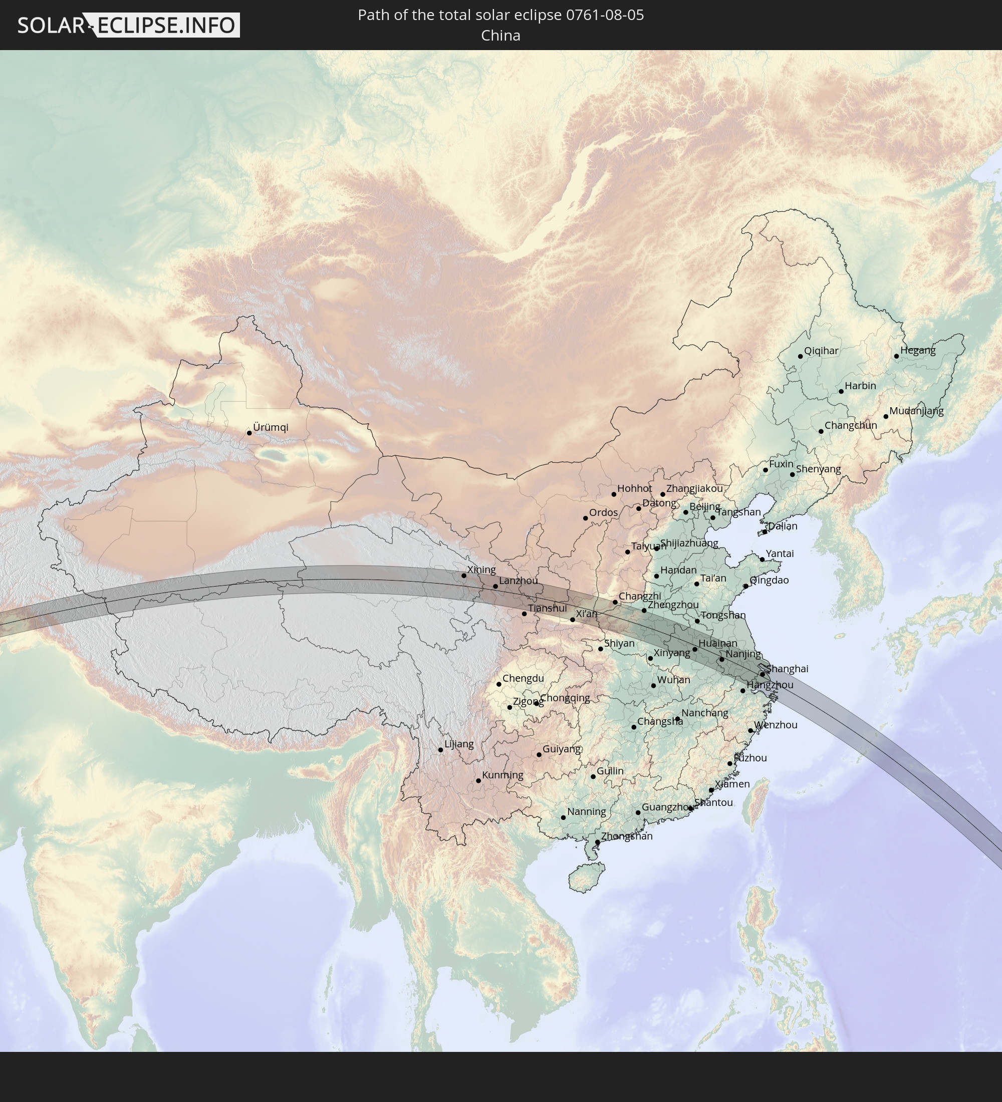 China
China
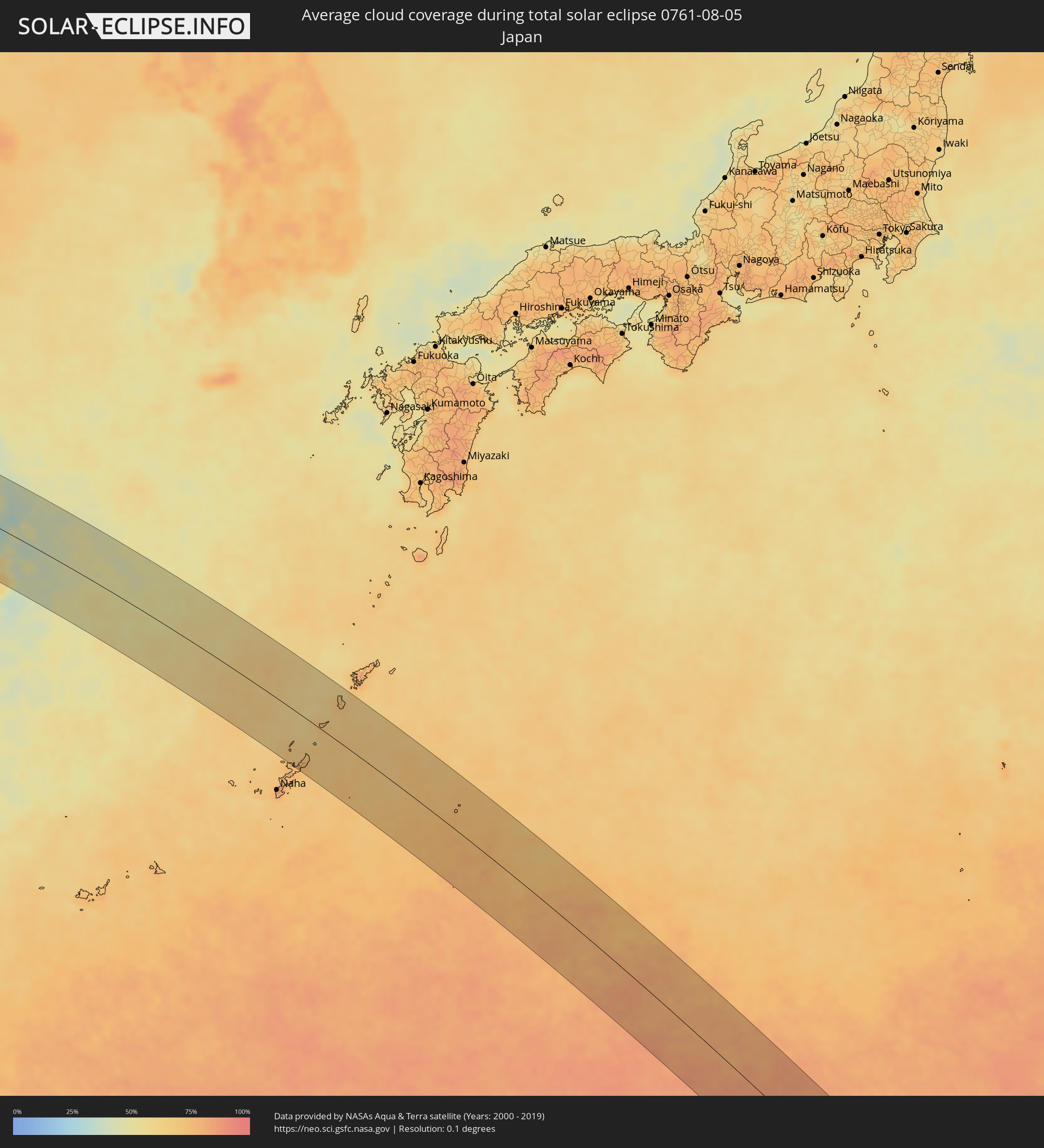
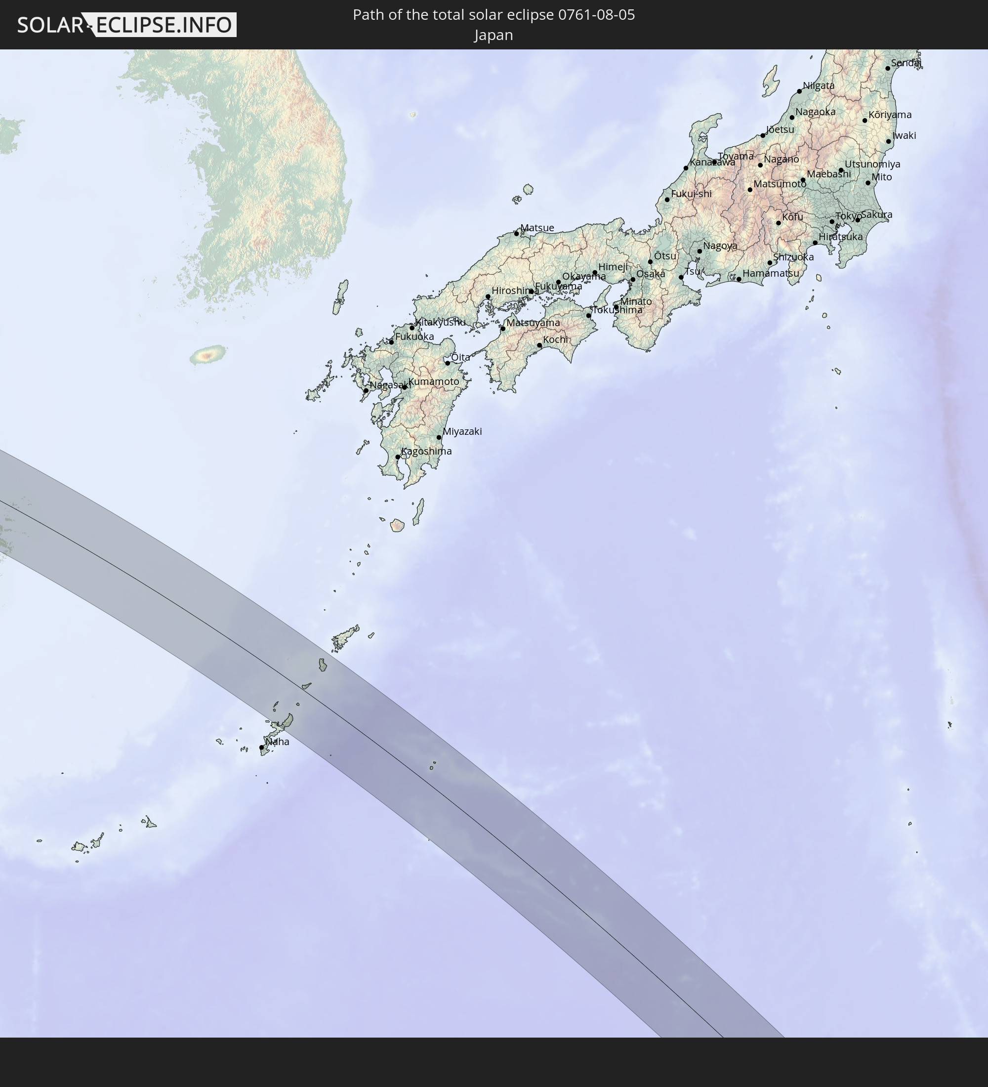 Japan
Japan
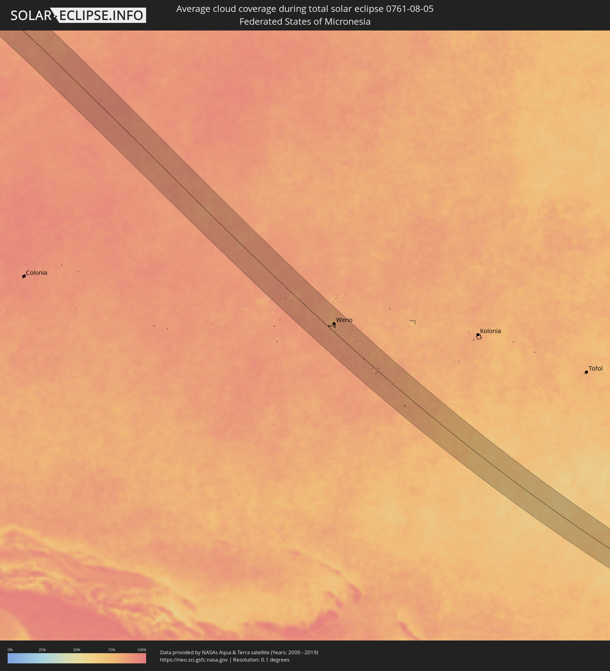
 Federated States of Micronesia
 Guam
Guam
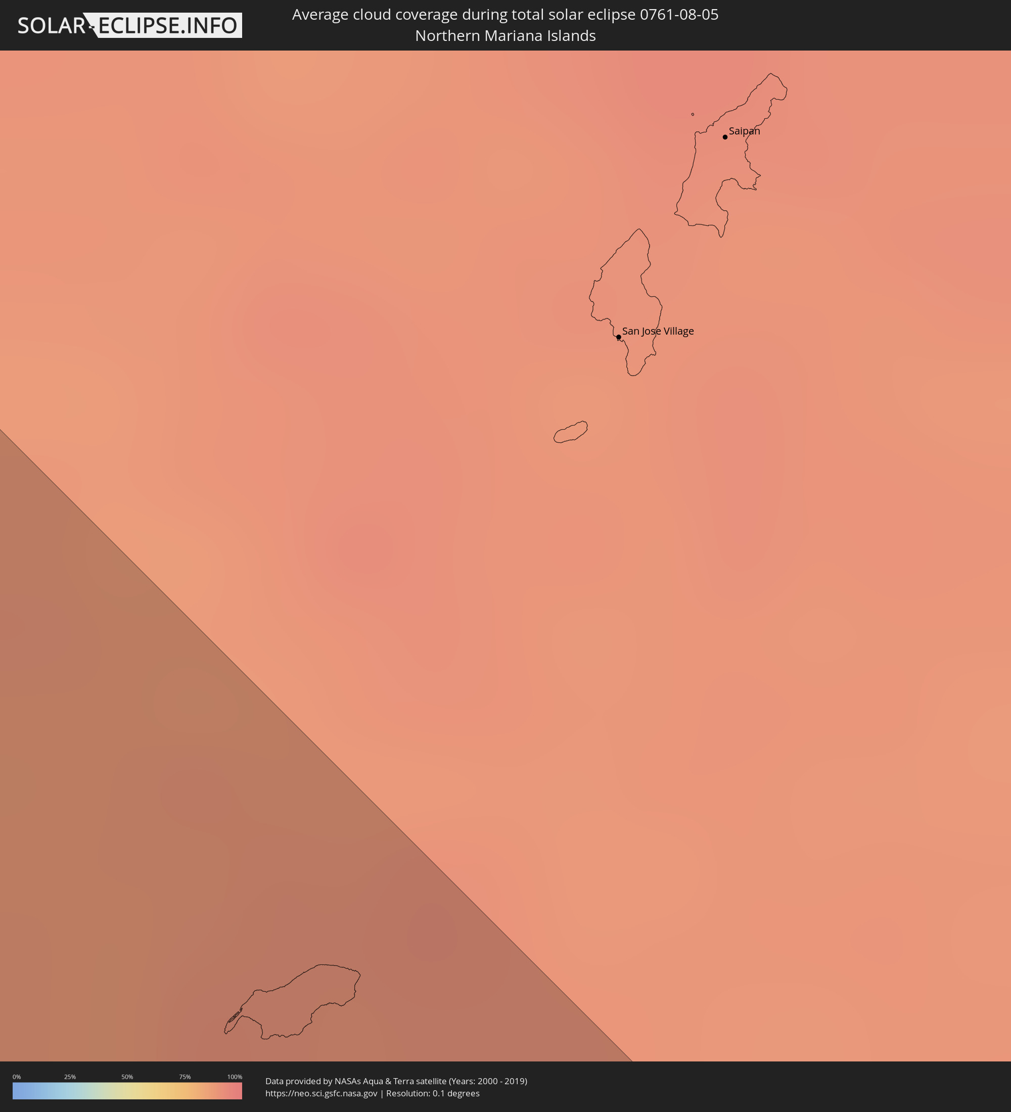
 Northern Mariana Islands
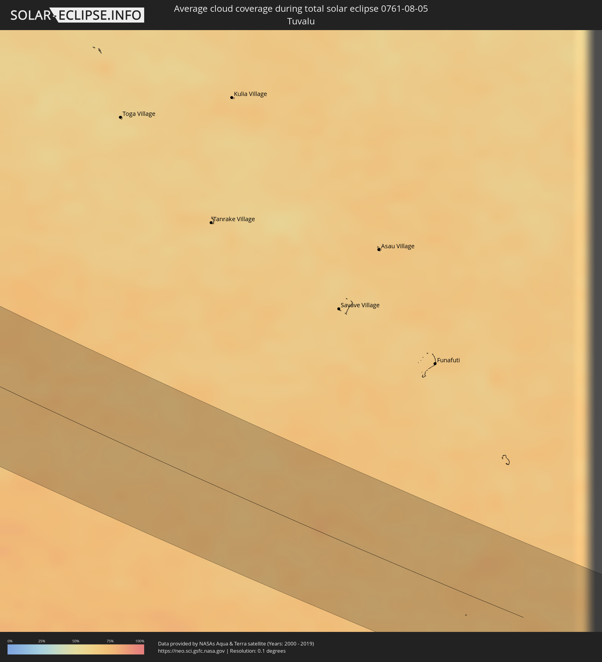
 Tuvalu
In den folgenden Ländern ist die Sonnenfinsternis partiell zu sehen
 Fiji
Fiji
 Russia
 United States
 New Zealand
 United States Minor Outlying Islands
 Wallis and Futuna
 Tonga
Tonga
 Kiribati
 Samoa
Samoa
 Tokelau
 American Samoa
 Finland
 Iran
Iran
 Azerbaijan
 Kazakhstan
 Oman
Oman
 Turkmenistan
 Uzbekistan
 Afghanistan
 Pakistan
 Tajikistan
 India
India
 Kyrgyzstan
 Maldives
 China
China
 Sri Lanka
 Nepal
Nepal
 Mongolia
 Bangladesh
 Bhutan
 Myanmar
 Indonesia
 Thailand
 Malaysia
 Laos
Laos
 Vietnam
 Cambodia
 Australia
 Macau
Macau
 Hong Kong
 Brunei
 Taiwan
 Philippines
 Japan
Japan
 East Timor
 North Korea
 South Korea
 Palau
Palau
 Federated States of Micronesia
 Papua New Guinea
 Guam
Guam
 Northern Mariana Islands
 Solomon Islands
 New Caledonia
 Marshall Islands
 Vanuatu
 Nauru
Nauru
 Norfolk Island
 Tuvalu
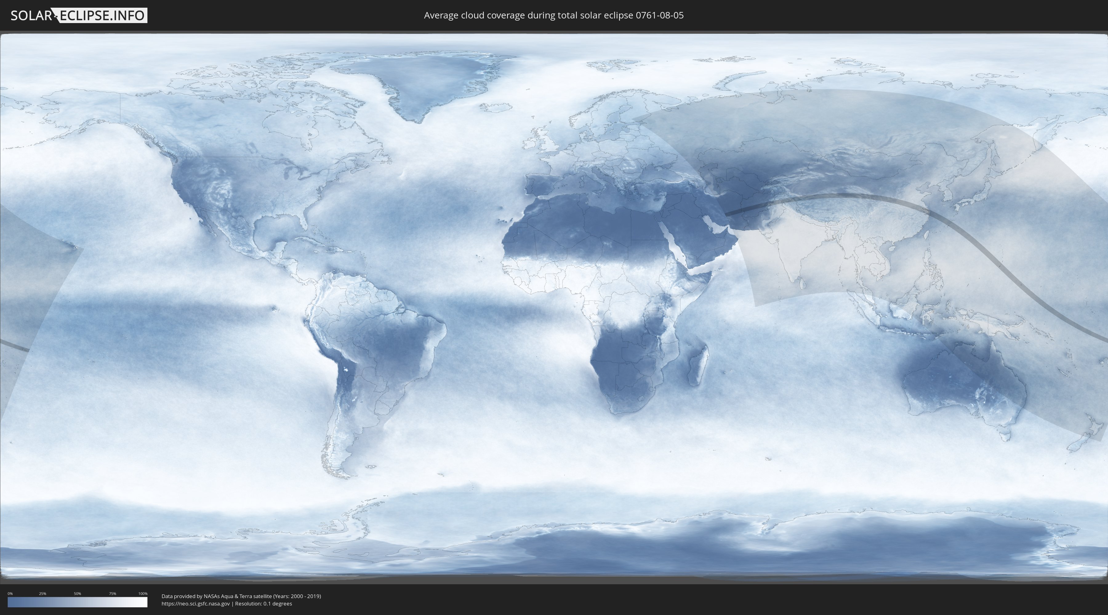
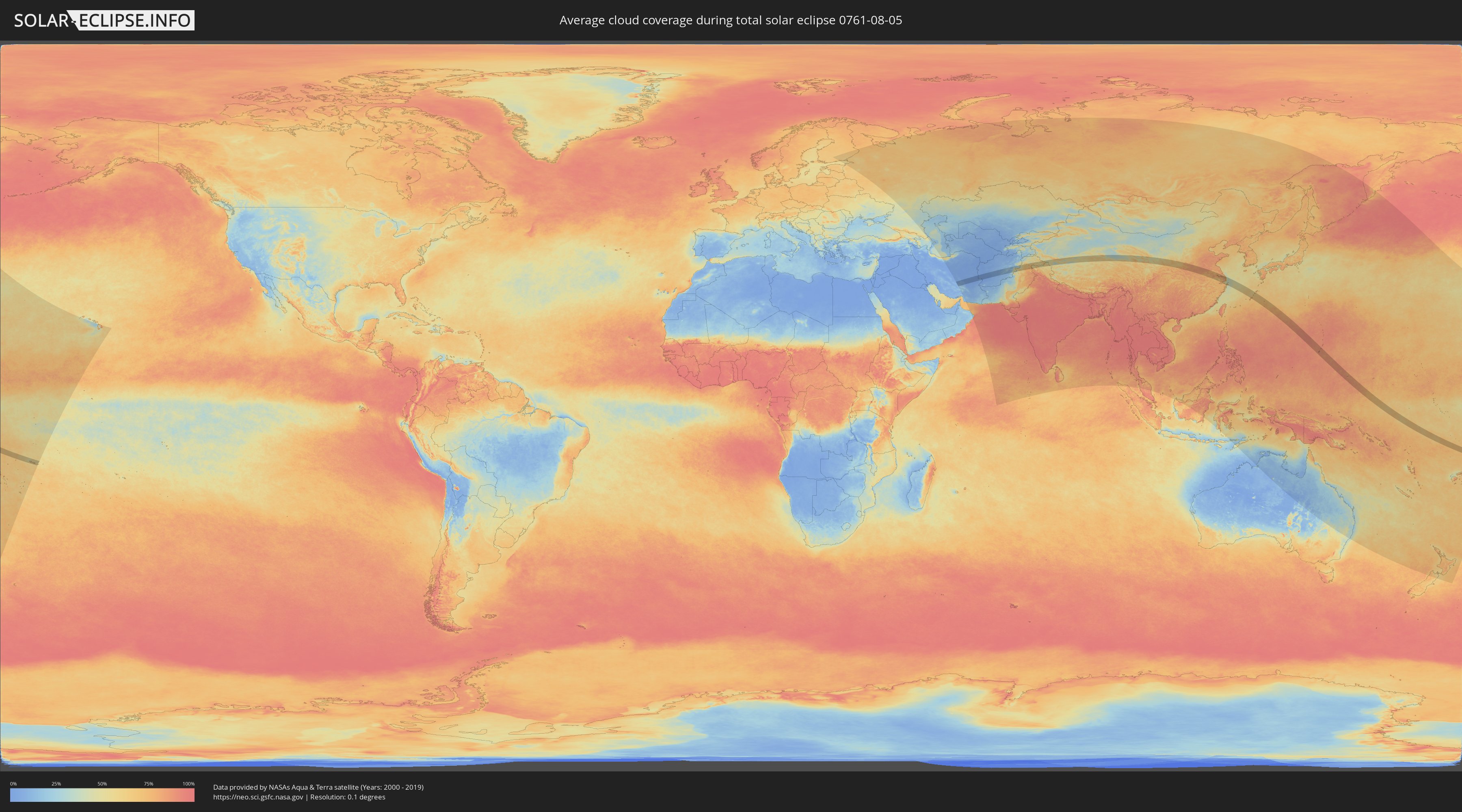
How will be the weather during the total solar eclipse on 08/05/0761?
Where is the best place to see the total solar eclipse of 08/05/0761?
The following maps show the average cloud coverage for the day of the total solar eclipse.
With the help of these maps, it is possible to find the place along the eclipse path, which has the best
chance of a cloudless sky.
Nevertheless, you should consider local circumstances and inform about the weather of your chosen
observation site.
The data is provided by NASAs satellites
AQUA and TERRA.
The cloud maps are averaged over a period of 19 years (2000 - 2019).
Detailed country maps
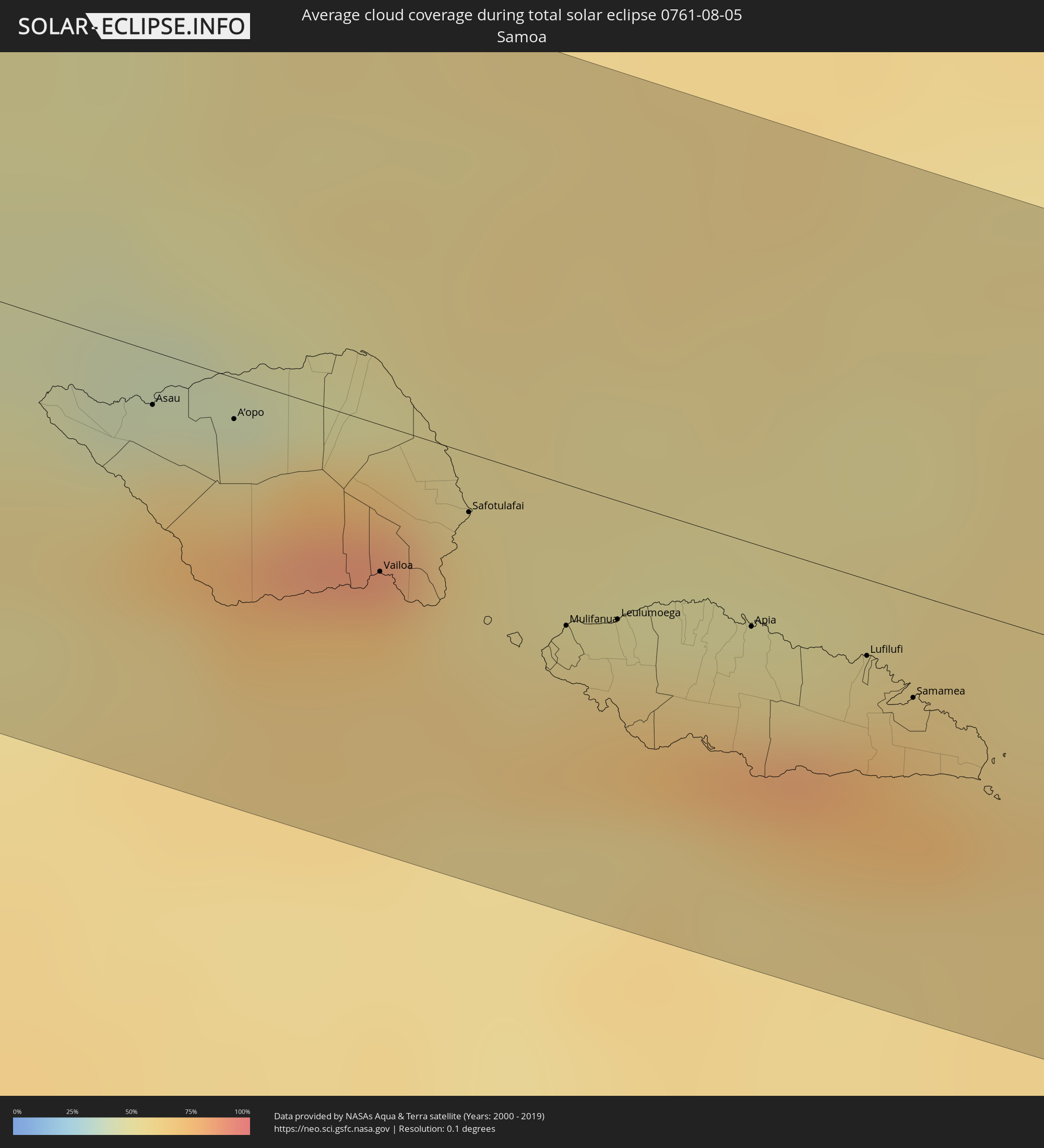 Samoa
Samoa
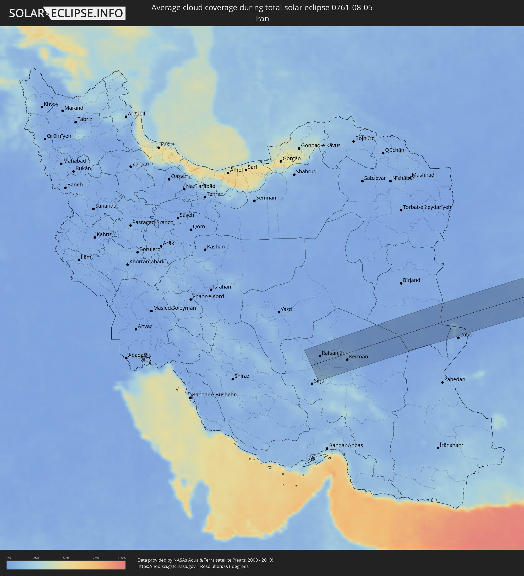 Iran
Iran
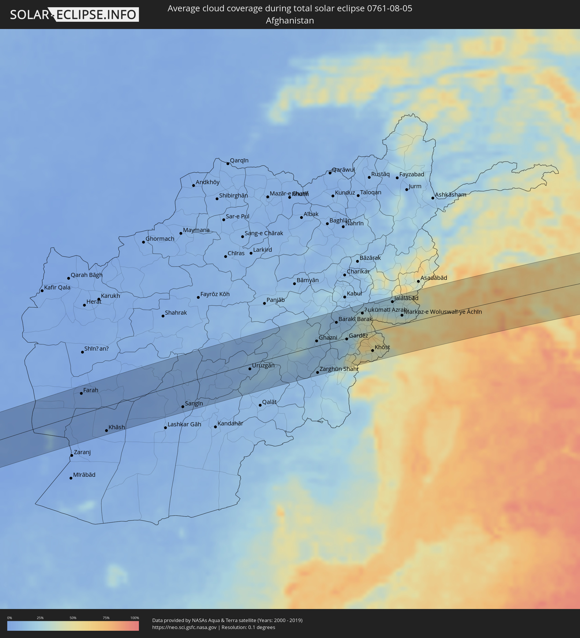 Afghanistan
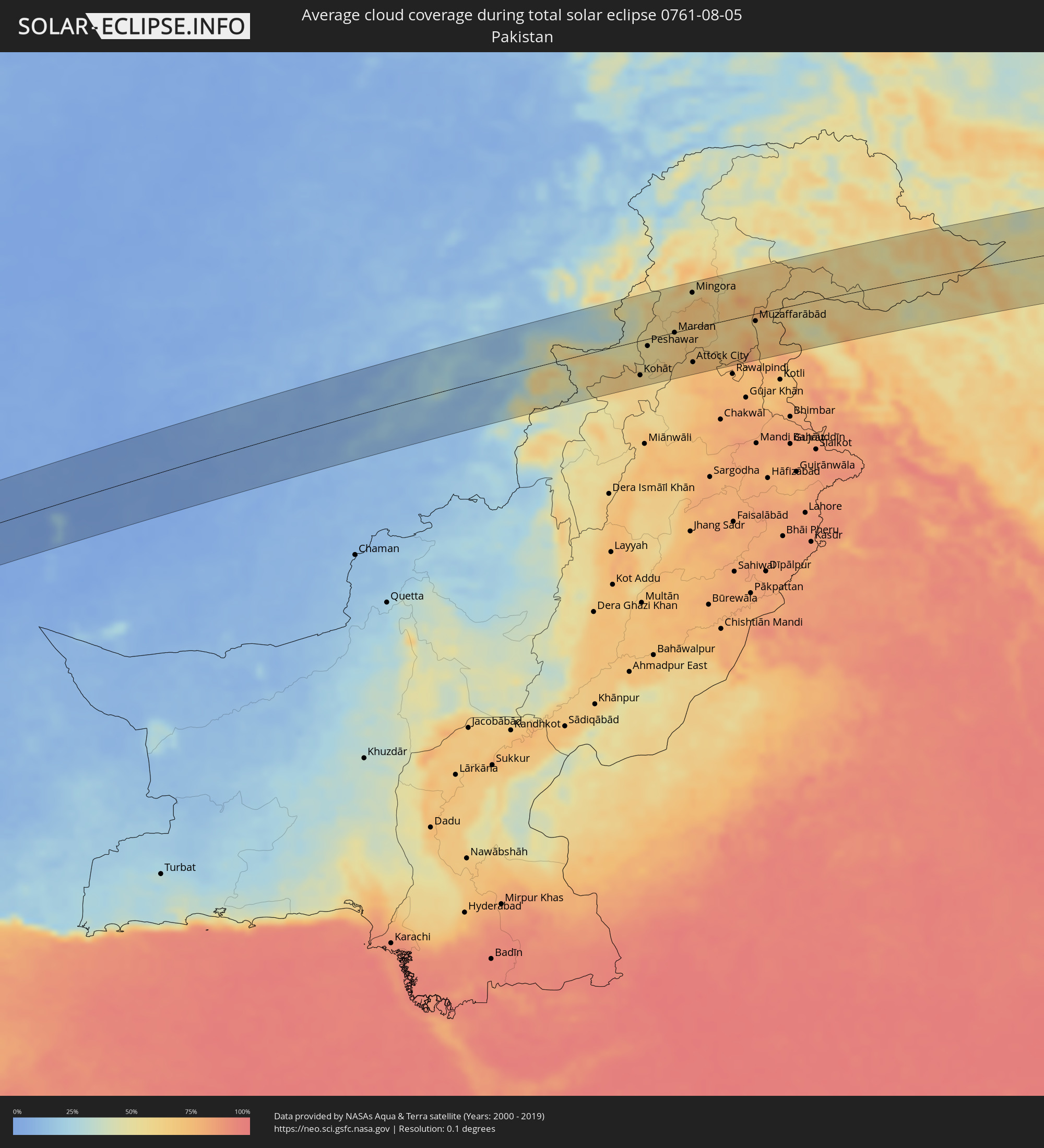 Pakistan
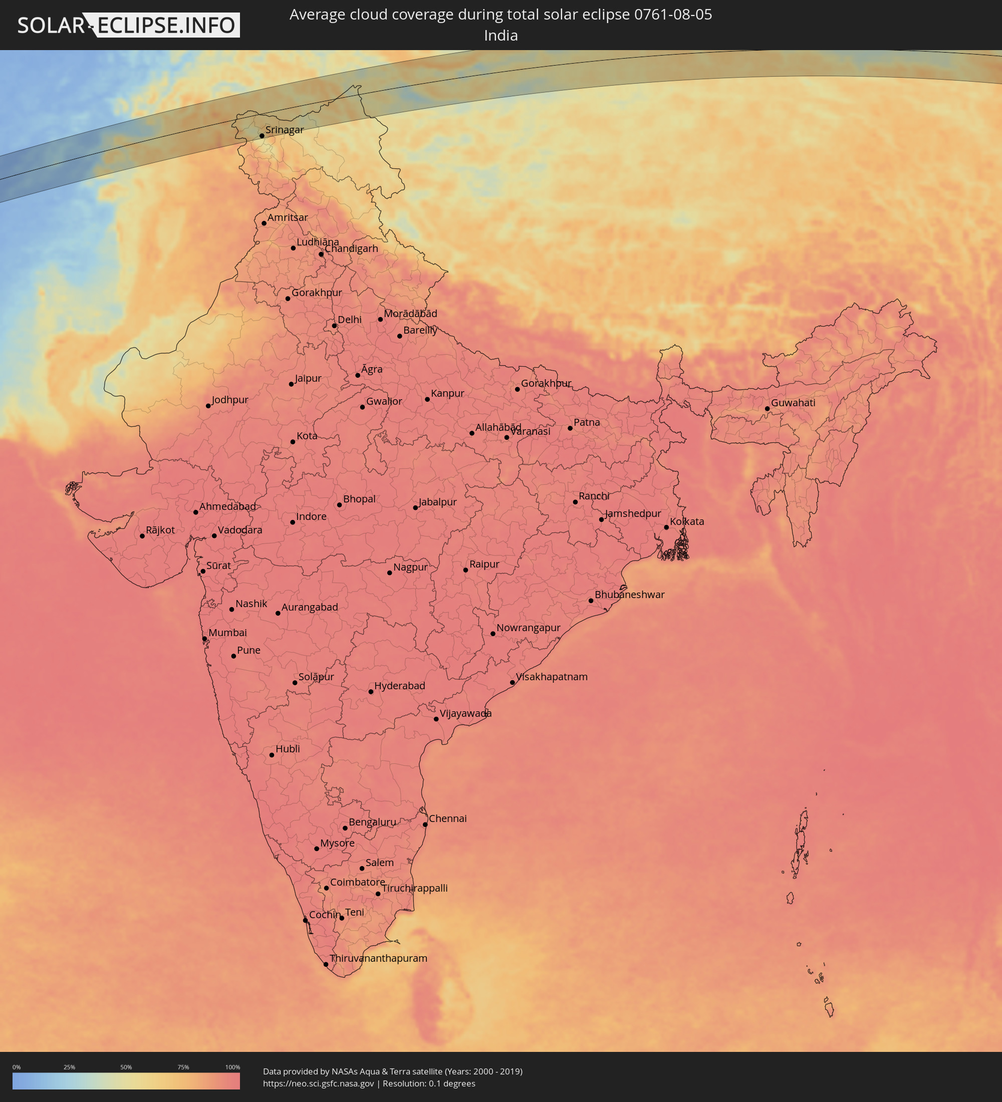 India
India
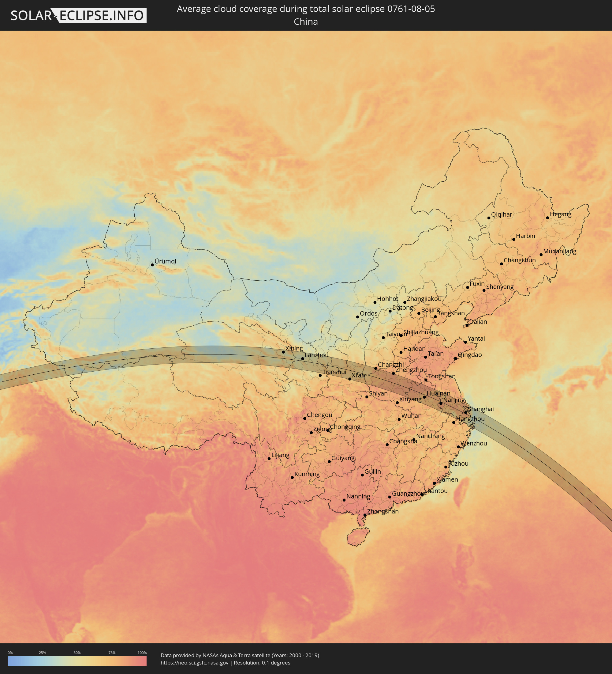 China
China
 Japan
Japan
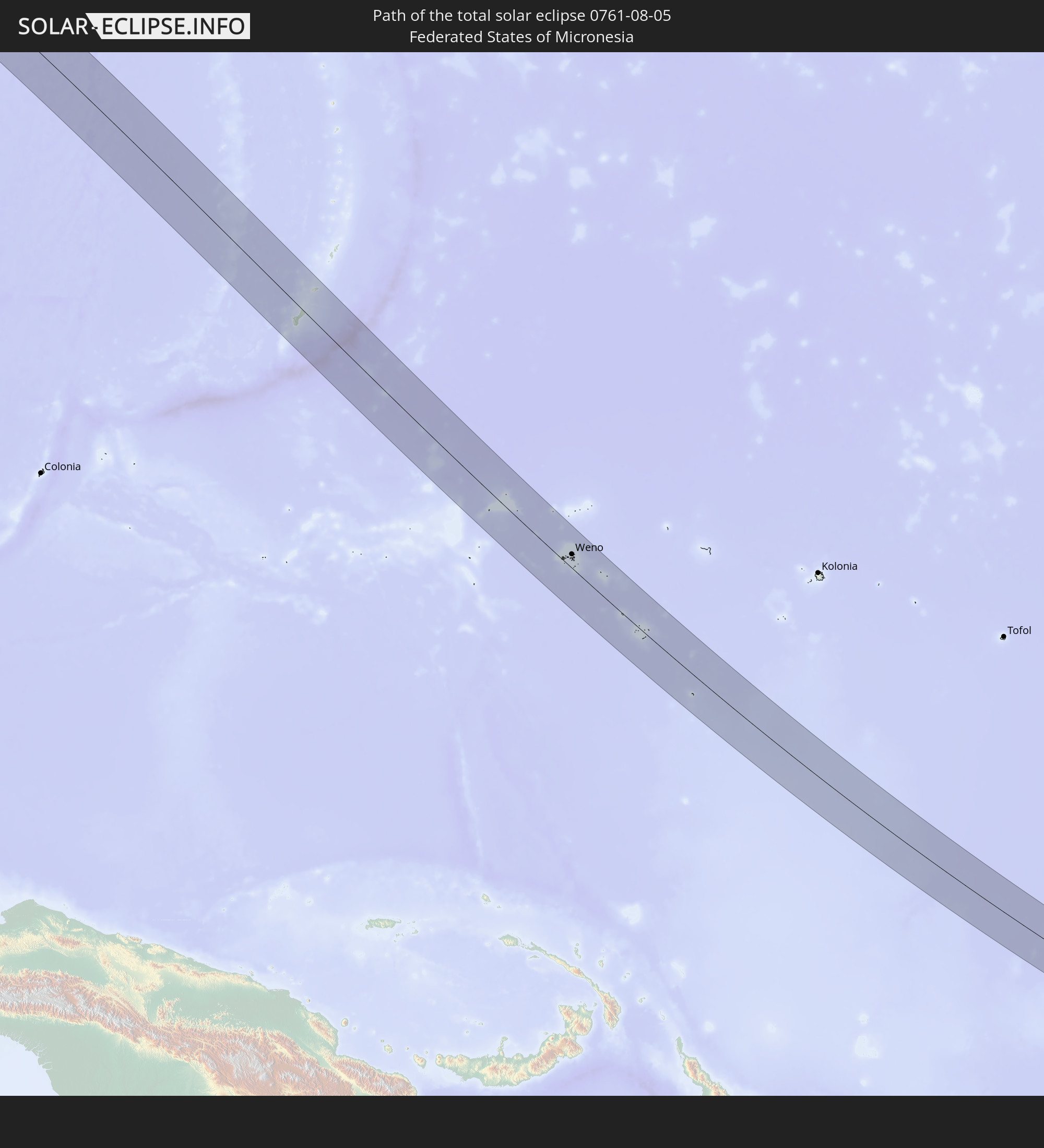
 Federated States of Micronesia
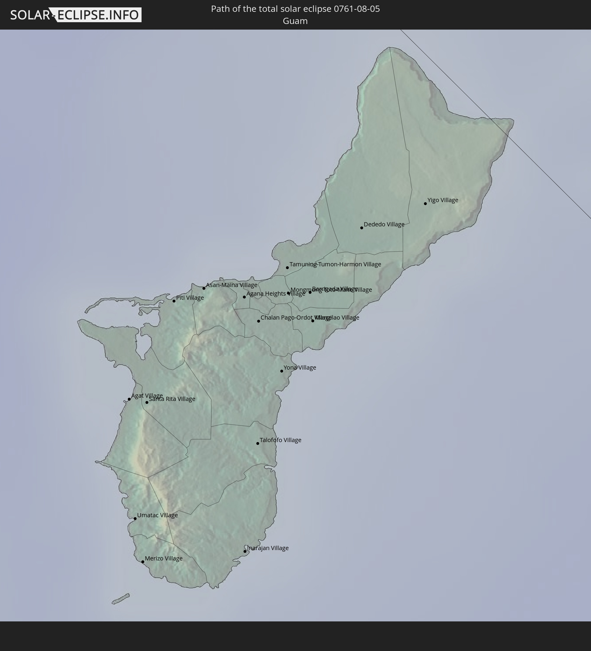
 Guam
Guam
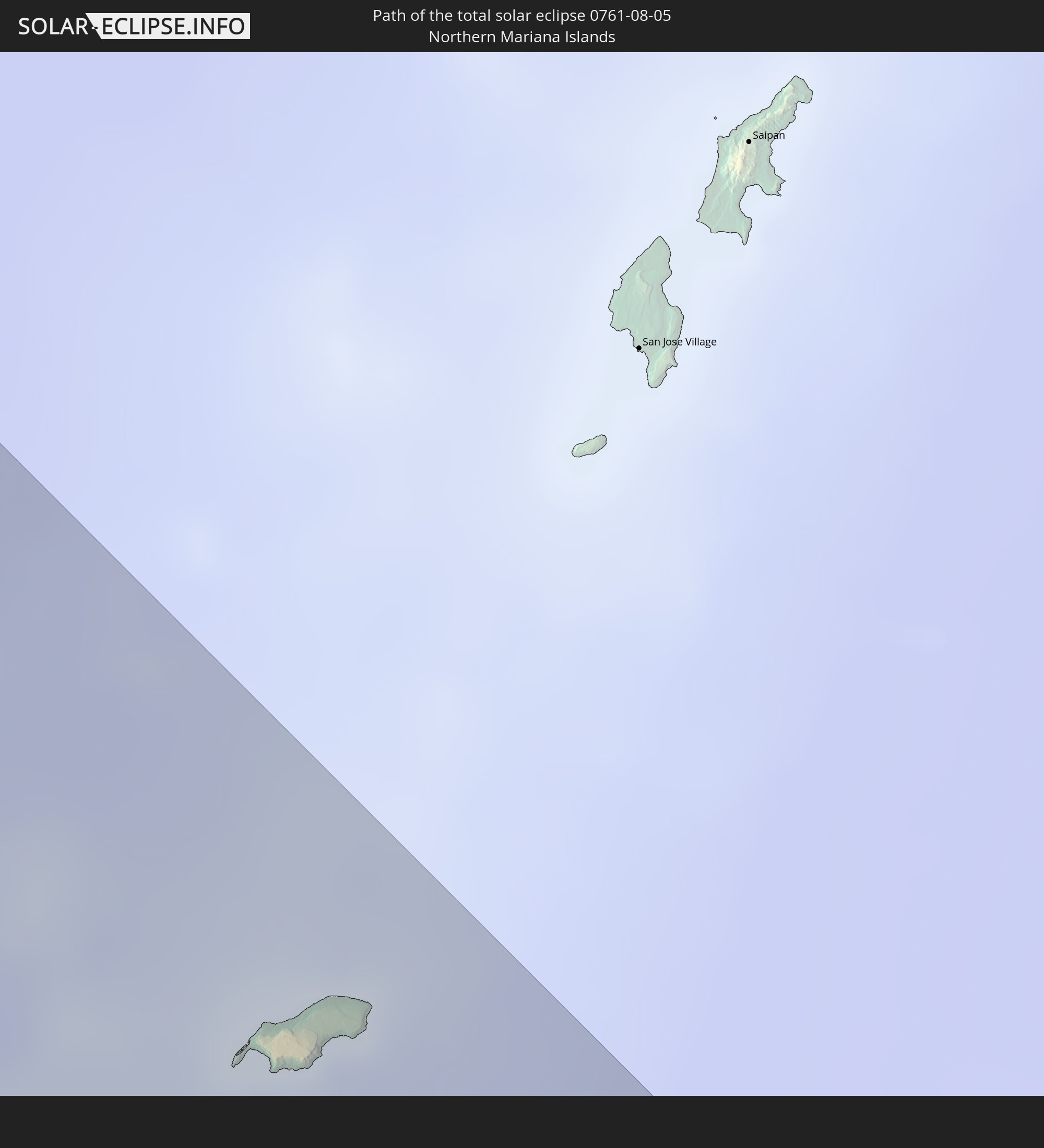
 Northern Mariana Islands
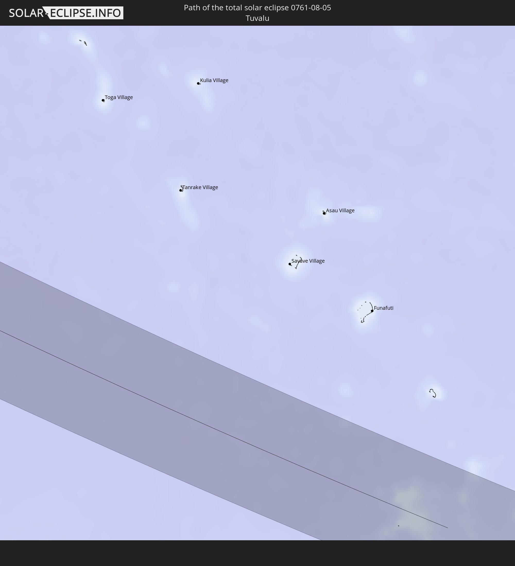
 Tuvalu
Cities inside the path of the eclipse
The following table shows all locations with a population of more than 5,000 inside the eclipse path. Cities which have more than 100,000 inhabitants are marked bold. A click at the locations opens a detailed map.
| City | Type | Eclipse duration | Local time of max. eclipse | Distance to central line | Ø Cloud coverage |
|
Asau, Vaisigano
|
total | - | 17:42:12 UTC-11:26 | 8 km | 61% |
|
A’opo, Gagaifomauga
|
total | - | 17:42:12 UTC-11:26 | 6 km | 61% |
|
Vailoa, Palauli
|
total | - | 17:42:17 UTC-11:26 | 22 km | 62% |
|
Safotulafai, Fa‘asaleleaga
|
total | - | 17:42:14 UTC-11:26 | 9 km | 59% |
|
Mulifanua, Aiga-i-le-Tai
|
total | - | 17:42:17 UTC-11:26 | 21 km | 62% |
|
Leulumoega, A'ana
|
total | - | 17:42:17 UTC-11:26 | 18 km | 62% |
|
Apia, Tuamasaga
|
total | - | 17:42:16 UTC-11:26 | 13 km | 59% |
|
Lufilufi, Atua
|
total | - | 17:42:16 UTC-11:26 | 11 km | 75% |
|
Samamea, Va‘a-o-Fonoti
|
total | - | 17:42:17 UTC-11:26 | 16 km | 66% |
|
Rafsanjān, Kerman
|
total | - | 05:07:52 UTC+03:25 | 23 km | 4% |
|
Zarand, Kerman
|
total | - | 05:08:00 UTC+03:25 | 47 km | 8% |
|
Bardsīr, Kerman
|
total | - | 05:07:35 UTC+03:25 | 47 km | 10% |
|
Kerman, Kerman
|
total | - | 05:07:42 UTC+03:25 | 25 km | 5% |
|
Farah, Farah
|
total | - | 05:42:51 UTC+04:00 | 49 km | 1% |
|
Khāsh, Nimroz
|
total | - | 05:42:27 UTC+04:00 | 60 km | 1% |
|
Sangīn, Helmand
|
total | - | 05:42:55 UTC+04:00 | 57 km | 5% |
|
Tarinkot, Oruzgan
|
total | - | 05:43:21 UTC+04:00 | 24 km | 8% |
|
Uruzgān, Oruzgan
|
total | - | 05:43:38 UTC+04:00 | 12 km | 10% |
|
Ghazni, Ghazni
|
total | - | 05:44:21 UTC+04:00 | 12 km | 15% |
|
Zarghūn Shahr, Paktika
|
total | - | 05:43:58 UTC+04:00 | 65 km | 11% |
|
Sharan, Paktika
|
total | - | 05:44:13 UTC+04:00 | 36 km | 16% |
|
Zaṟah Sharan, Paktika
|
total | - | 05:44:13 UTC+04:00 | 41 km | 16% |
|
Barakī Barak, Logar
|
total | - | 05:44:42 UTC+04:00 | 44 km | 13% |
|
Pul-e ‘Alam, Logar
|
total | - | 05:44:44 UTC+04:00 | 45 km | 14% |
|
Gardēz, Paktia
|
total | - | 05:44:34 UTC+04:00 | 3 km | 18% |
|
Ḩukūmatī Azrah, Logar
|
total | - | 05:45:00 UTC+04:00 | 50 km | 33% |
|
Khōst, Khowst
|
total | - | 05:44:37 UTC+04:00 | 46 km | 42% |
|
Jalālābād, Nangarhar
|
total | - | 05:45:22 UTC+04:00 | 59 km | 27% |
|
Markaz-e Woluswalī-ye Āchīn, Nangarhar
|
total | - | 05:45:16 UTC+04:00 | 21 km | 40% |
|
Bāsawul, Nangarhar
|
total | - | 05:45:24 UTC+04:00 | 30 km | 30% |
|
Hangu, Khyber Pakhtunkhwa
|
total | - | 06:13:16 UTC+04:28 | 51 km | 66% |
|
Kohāt, Khyber Pakhtunkhwa
|
total | - | 06:13:25 UTC+04:28 | 54 km | 61% |
|
Shabqadar, Khyber Pakhtunkhwa
|
total | - | 06:13:48 UTC+04:28 | 12 km | 54% |
|
Peshawar, Khyber Pakhtunkhwa
|
total | - | 06:13:41 UTC+04:28 | 11 km | 56% |
|
Tangi, Khyber Pakhtunkhwa
|
total | - | 06:13:52 UTC+04:28 | 19 km | 57% |
|
Chārsadda, Khyber Pakhtunkhwa
|
total | - | 06:13:49 UTC+04:28 | 1 km | 55% |
|
Utmānzai, Khyber Pakhtunkhwa
|
total | - | 06:13:51 UTC+04:28 | 4 km | 57% |
|
Pabbi, Khyber Pakhtunkhwa
|
total | - | 06:13:46 UTC+04:28 | 16 km | 55% |
|
Bat Khela, Khyber Pakhtunkhwa
|
total | - | 06:14:10 UTC+04:28 | 46 km | 59% |
|
Risalpur Cantonment, Khyber Pakhtunkhwa
|
total | - | 06:13:51 UTC+04:28 | 14 km | 62% |
|
Nowshera Cantonment, Khyber Pakhtunkhwa
|
total | - | 06:13:49 UTC+04:28 | 21 km | 63% |
|
Mardan, Khyber Pakhtunkhwa
|
total | - | 06:13:57 UTC+04:28 | 0 km | 64% |
|
Mingora, Khyber Pakhtunkhwa
|
total | - | 06:14:23 UTC+04:28 | 56 km | 61% |
|
Attock City, Punjab
|
total | - | 06:13:50 UTC+04:28 | 54 km | 74% |
|
Zaida, Khyber Pakhtunkhwa
|
total | - | 06:14:02 UTC+04:28 | 25 km | 67% |
|
Swābi, Khyber Pakhtunkhwa
|
total | - | 06:14:04 UTC+04:28 | 18 km | 67% |
|
Hazro, Punjab
|
total | - | 06:13:57 UTC+04:28 | 41 km | 74% |
|
Topi, Khyber Pakhtunkhwa
|
total | - | 06:14:05 UTC+04:28 | 27 km | 66% |
|
Khalābat, Khyber Pakhtunkhwa
|
total | - | 06:14:11 UTC+04:28 | 33 km | 63% |
|
Harīpur, Khyber Pakhtunkhwa
|
total | - | 06:14:10 UTC+04:28 | 41 km | 70% |
|
Haveliān, Khyber Pakhtunkhwa
|
total | - | 06:14:17 UTC+04:28 | 40 km | 70% |
|
Mānsehra, Khyber Pakhtunkhwa
|
total | - | 06:14:27 UTC+04:28 | 10 km | 68% |
|
Abbottābād, Khyber Pakhtunkhwa
|
total | - | 06:14:21 UTC+04:28 | 31 km | 70% |
|
Muzaffarābād, Azad Kashmir
|
total | - | 06:14:35 UTC+04:28 | 12 km | 61% |
|
Rāwala Kot, Azad Kashmir
|
partial | - | 06:14:25 UTC+04:28 | 73 km | 77% |
|
Uri, Kashmir
|
total | - | 07:07:37 UTC+05:21 | 55 km | 69% |
|
Kupwāra, Kashmir
|
total | - | 07:07:41 UTC+05:21 | 64 km | 80% |
|
Bāramūla, Kashmir
|
total | - | 07:07:49 UTC+05:21 | 46 km | 57% |
|
Sopur, Kashmir
|
total | - | 07:07:55 UTC+05:21 | 40 km | 44% |
|
Pattan, Kashmir
|
total | - | 07:07:53 UTC+05:21 | 56 km | 49% |
|
Hājan, Kashmir
|
total | - | 07:07:59 UTC+05:21 | 42 km | 45% |
|
Bandipura, Kashmir
|
total | - | 07:08:04 UTC+05:21 | 30 km | 45% |
|
Sumbal, Kashmir
|
total | - | 07:07:58 UTC+05:21 | 50 km | 49% |
|
Soyībug, Kashmir
|
total | - | 07:07:54 UTC+05:21 | 68 km | 51% |
|
Gāndarbal, Kashmir
|
total | - | 07:08:01 UTC+05:21 | 53 km | 50% |
|
Srinagar, Kashmir
|
total | - | 07:07:57 UTC+05:21 | 69 km | 51% |
|
Kargil, Kashmir
|
total | - | 07:08:49 UTC+05:21 | 42 km | 45% |
|
Xining, Qinghai
|
total | - | 10:13:02 UTC+08:00 | 57 km | 47% |
|
Lanzhou, Gansu
|
total | - | 10:16:06 UTC+08:00 | 19 km | 46% |
|
Xianyang, Shaanxi
|
total | - | 10:24:21 UTC+08:00 | 83 km | 73% |
|
Huayin, Shaanxi
|
total | - | 10:26:38 UTC+08:00 | 28 km | 64% |
|
Changzhi, Shanxi
|
total | - | 10:29:16 UTC+08:00 | 83 km | 77% |
|
Luoyang, Henan
|
total | - | 10:30:48 UTC+08:00 | 46 km | 83% |
|
Pingdingshan, Henan
|
total | - | 10:32:53 UTC+08:00 | 30 km | 82% |
|
Zhengzhou, Henan
|
total | - | 10:32:55 UTC+08:00 | 87 km | 82% |
|
Jiangguanchi, Henan
|
total | - | 10:33:35 UTC+08:00 | 26 km | 82% |
|
Luohe, Henan
|
total | - | 10:34:23 UTC+08:00 | 27 km | 86% |
|
Zhoukou, Henan
|
total | - | 10:35:26 UTC+08:00 | 1 km | 85% |
|
Huainan, Anhui
|
total | - | 10:40:44 UTC+08:00 | 26 km | 78% |
|
Bengbu, Anhui
|
total | - | 10:41:10 UTC+08:00 | 20 km | 82% |
|
Chuzhou, Anhui
|
total | - | 10:43:33 UTC+08:00 | 9 km | 80% |
|
Nanjing, Jiangsu
|
total | - | 10:44:45 UTC+08:00 | 17 km | 82% |
|
Yangzhou, Jiangsu
|
total | - | 10:45:43 UTC+08:00 | 43 km | 81% |
|
Zhenjiang, Jiangsu
|
total | - | 10:45:57 UTC+08:00 | 25 km | 82% |
|
Taizhou, Jiangsu
|
total | - | 10:46:34 UTC+08:00 | 72 km | 81% |
|
Changzhou, Jiangsu
|
total | - | 10:47:22 UTC+08:00 | 2 km | 81% |
|
Wuxi, Jiangsu
|
total | - | 10:48:15 UTC+08:00 | 5 km | 79% |
|
Suzhou, Jiangsu
|
total | - | 10:49:09 UTC+08:00 | 18 km | 80% |
|
Changshu City, Jiangsu
|
total | - | 10:49:05 UTC+08:00 | 22 km | 75% |
|
Jiaxing, Zhejiang
|
total | - | 10:50:05 UTC+08:00 | 67 km | 78% |
|
Nantong, Jiangsu
|
total | - | 10:48:57 UTC+08:00 | 66 km | 78% |
|
Shanghai, Shanghai
|
total | - | 10:50:59 UTC+08:00 | 11 km | 82% |
|
Agat Village, Agat
|
total | - | 14:07:16 UTC+10:00 | 38 km | 90% |
|
Umatac Village, Umatac
|
total | - | 14:07:27 UTC+10:00 | 45 km | 88% |
|
Merizo Village, Merizo
|
total | - | 14:07:31 UTC+10:00 | 47 km | 88% |
|
Santa Rita Village, Santa Rita
|
total | - | 14:07:18 UTC+10:00 | 37 km | 90% |
|
Piti Village, Piti
|
total | - | 14:07:11 UTC+10:00 | 30 km | 91% |
|
Asan-Maina Village, Asan
|
total | - | 14:07:12 UTC+10:00 | 27 km | 91% |
|
Agana Heights Village, Agana Heights
|
total | - | 14:07:16 UTC+10:00 | 25 km | 91% |
|
Inarajan Village, Inarajan
|
total | - | 14:07:38 UTC+10:00 | 40 km | 88% |
|
Hagåtña, Hagatna
|
total | - | 14:07:14 UTC+10:00 | 24 km | 91% |
|
Guam Government House, Hagatna
|
total | - | 14:07:15 UTC+10:00 | 25 km | 91% |
|
Sinajana Village, Sinajana
|
total | - | 14:07:16 UTC+10:00 | 25 km | 89% |
|
Talofofo Village, Talofofo
|
total | - | 14:07:29 UTC+10:00 | 33 km | 87% |
|
Chalan Pago-Ordot Village, Chalan Pago-Ordot
|
total | - | 14:07:19 UTC+10:00 | 26 km | 87% |
|
Yona Village, Yona
|
total | - | 14:07:25 UTC+10:00 | 27 km | 87% |
|
Tamuning-Tumon-Harmon Village, Tamuning
|
total | - | 14:07:16 UTC+10:00 | 21 km | 89% |
|
Mongmong-Toto-Maite Village, Mongmong-Toto-Maite
|
total | - | 14:07:18 UTC+10:00 | 22 km | 89% |
|
Barrigada Village, Barrigada
|
total | - | 14:07:20 UTC+10:00 | 21 km | 89% |
|
Mangilao Village, Mangilao
|
total | - | 14:07:23 UTC+10:00 | 23 km | 87% |
|
Dededo Village, Dededo
|
total | - | 14:07:18 UTC+10:00 | 14 km | 89% |
|
Yigo Village, Yigo
|
total | - | 14:07:21 UTC+10:00 | 9 km | 88% |
|
Weno, Chuuk
|
total | - | 14:28:10 UTC+10:00 | 29 km | 84% |