Total solar eclipse of 04/25/0822
| Day of week: | Monday |
| Maximum duration of eclipse: | 05m58s |
| Maximum width of eclipse path: | 262 km |
| Saros cycle: | 90 |
| Coverage: | 100% |
| Magnitude: | 1.075 |
| Gamma: | 0.3737 |
Wo kann man die Sonnenfinsternis vom 04/25/0822 sehen?
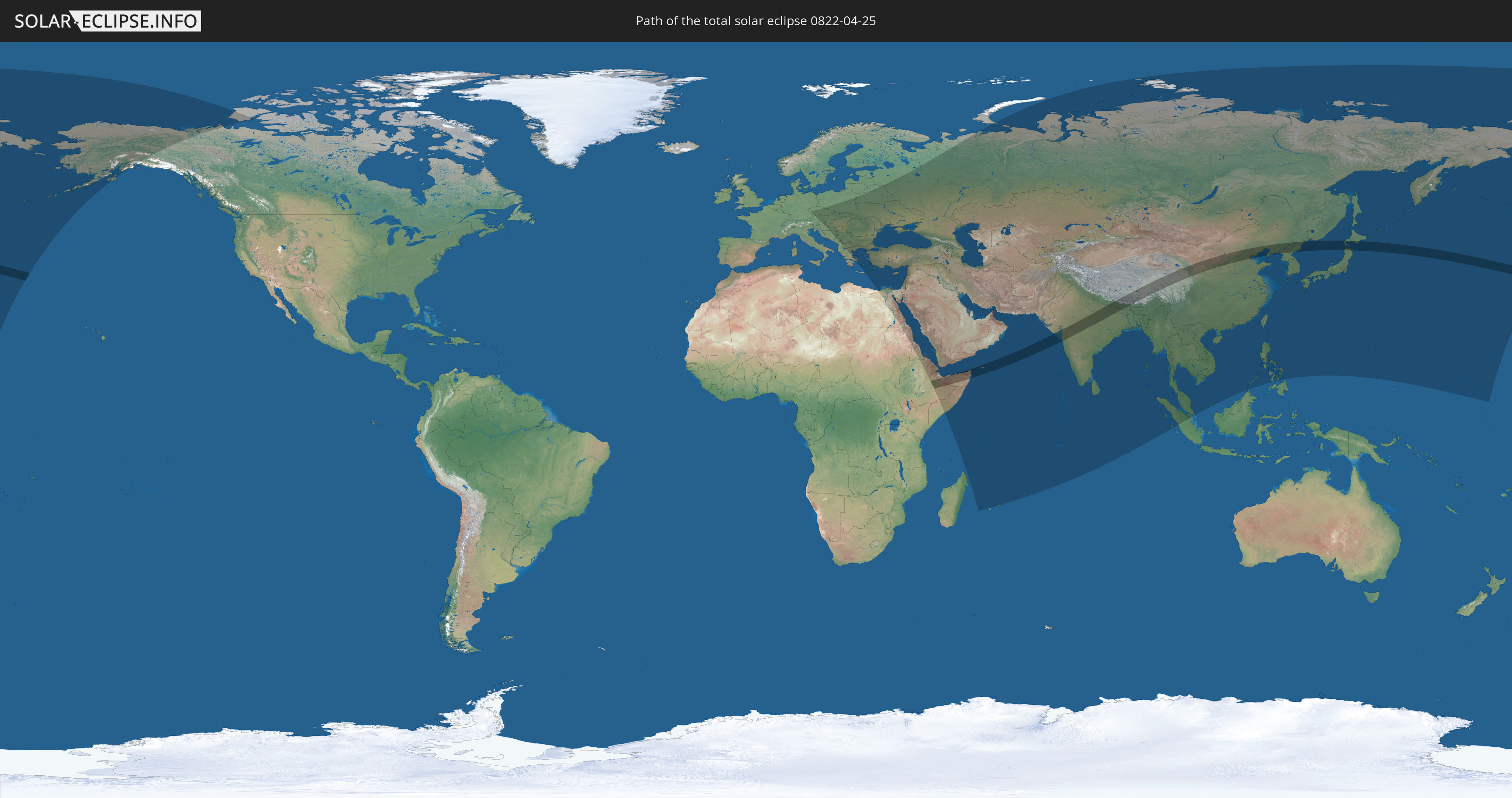
Die Sonnenfinsternis am 04/25/0822 kann man in 85 Ländern als partielle Sonnenfinsternis beobachten.
Der Finsternispfad verläuft durch 10 Länder. Nur in diesen Ländern ist sie als total Sonnenfinsternis zu sehen.
In den folgenden Ländern ist die Sonnenfinsternis total zu sehen
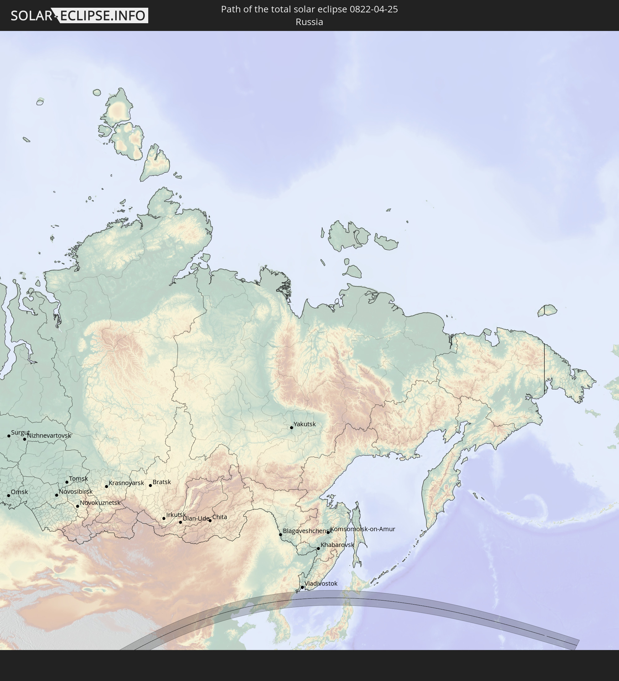 Russia
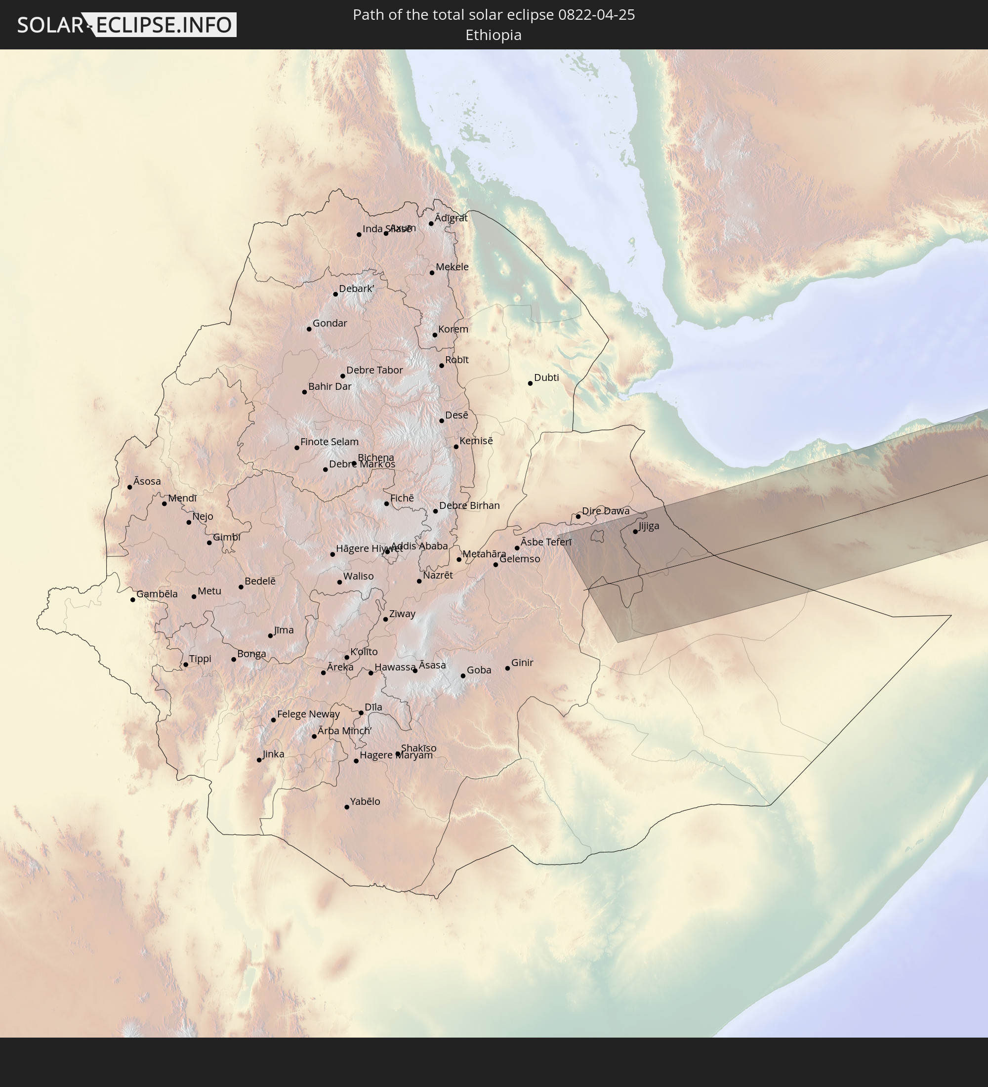 Ethiopia
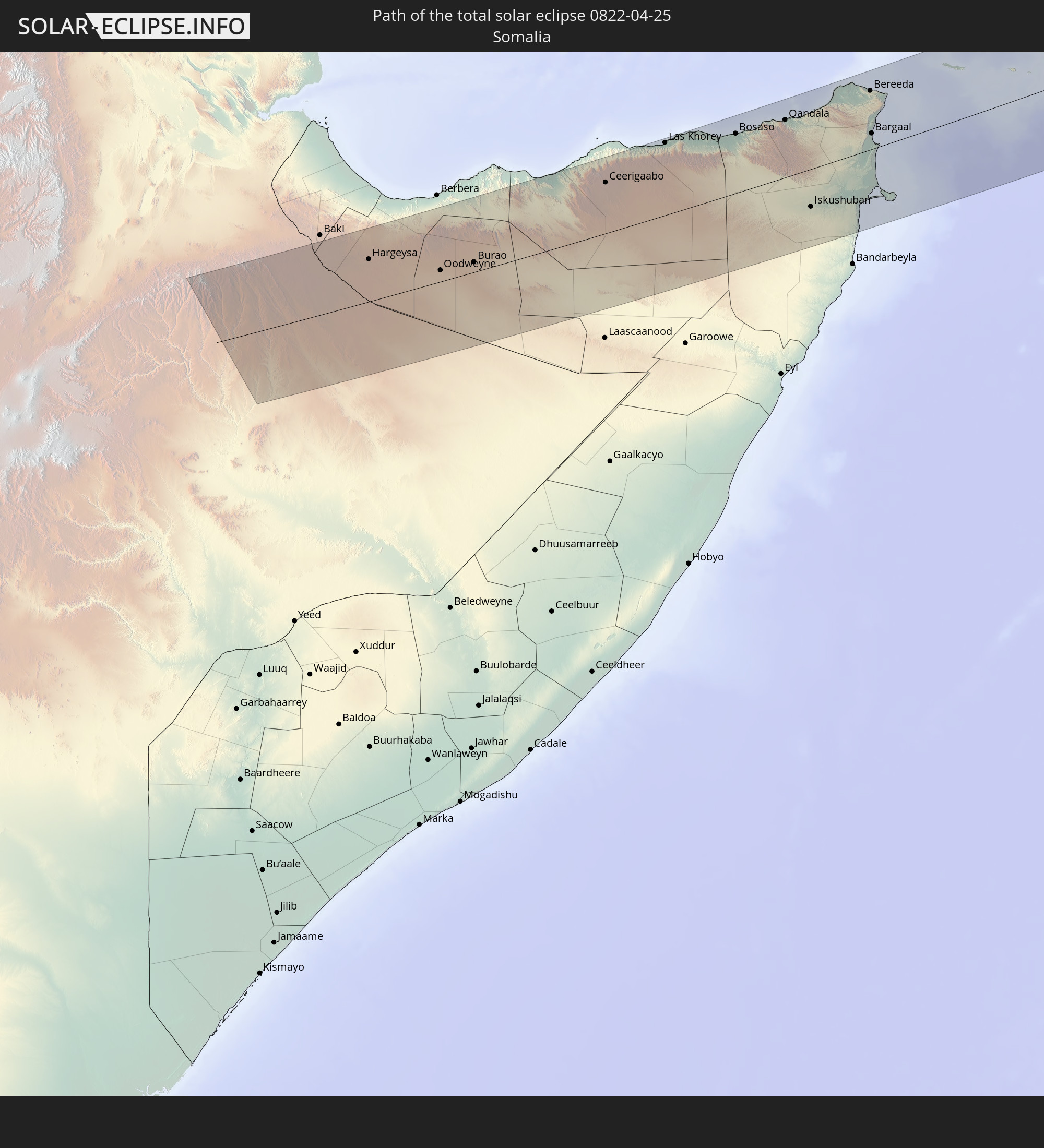 Somalia
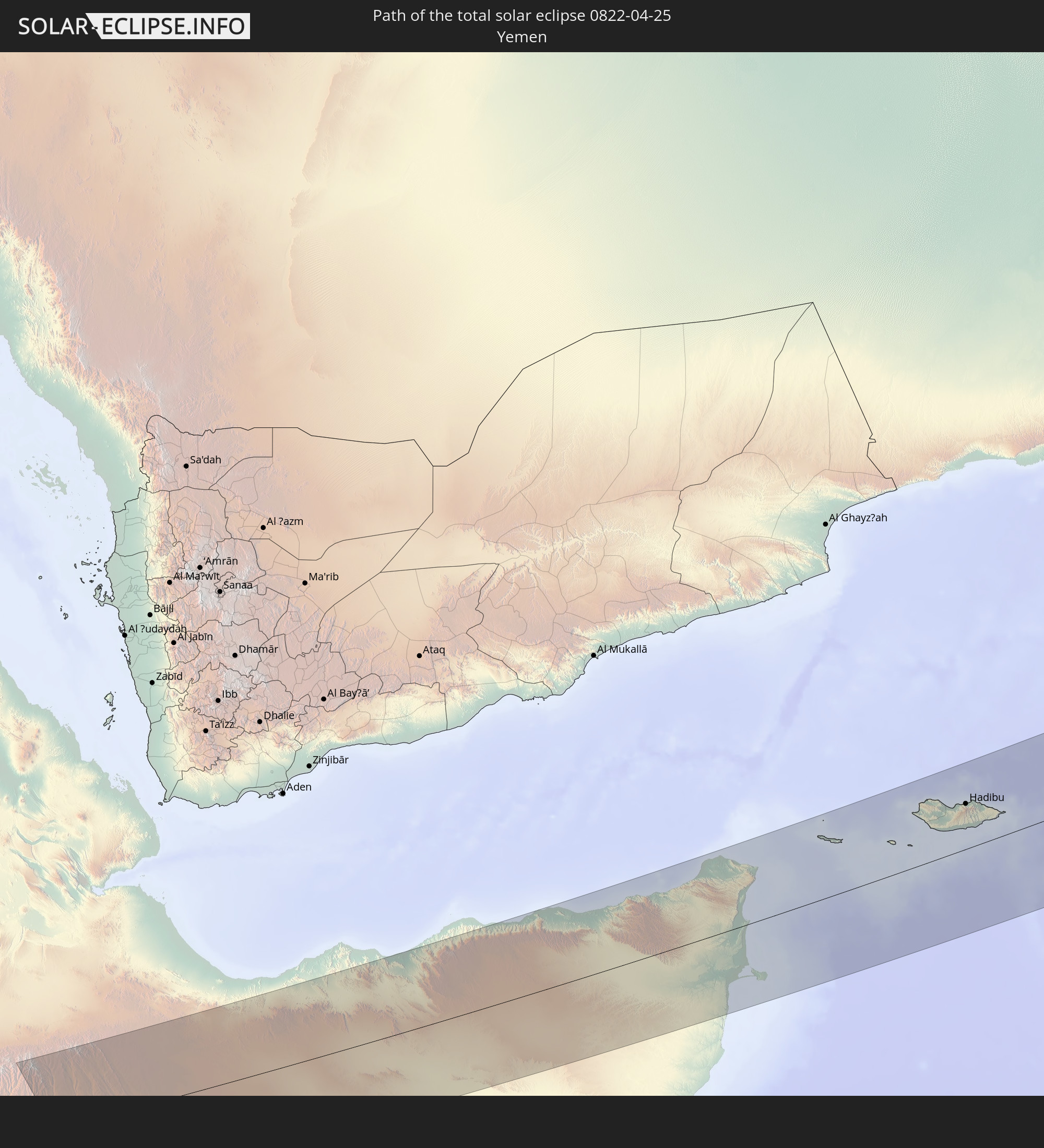 Yemen
Yemen
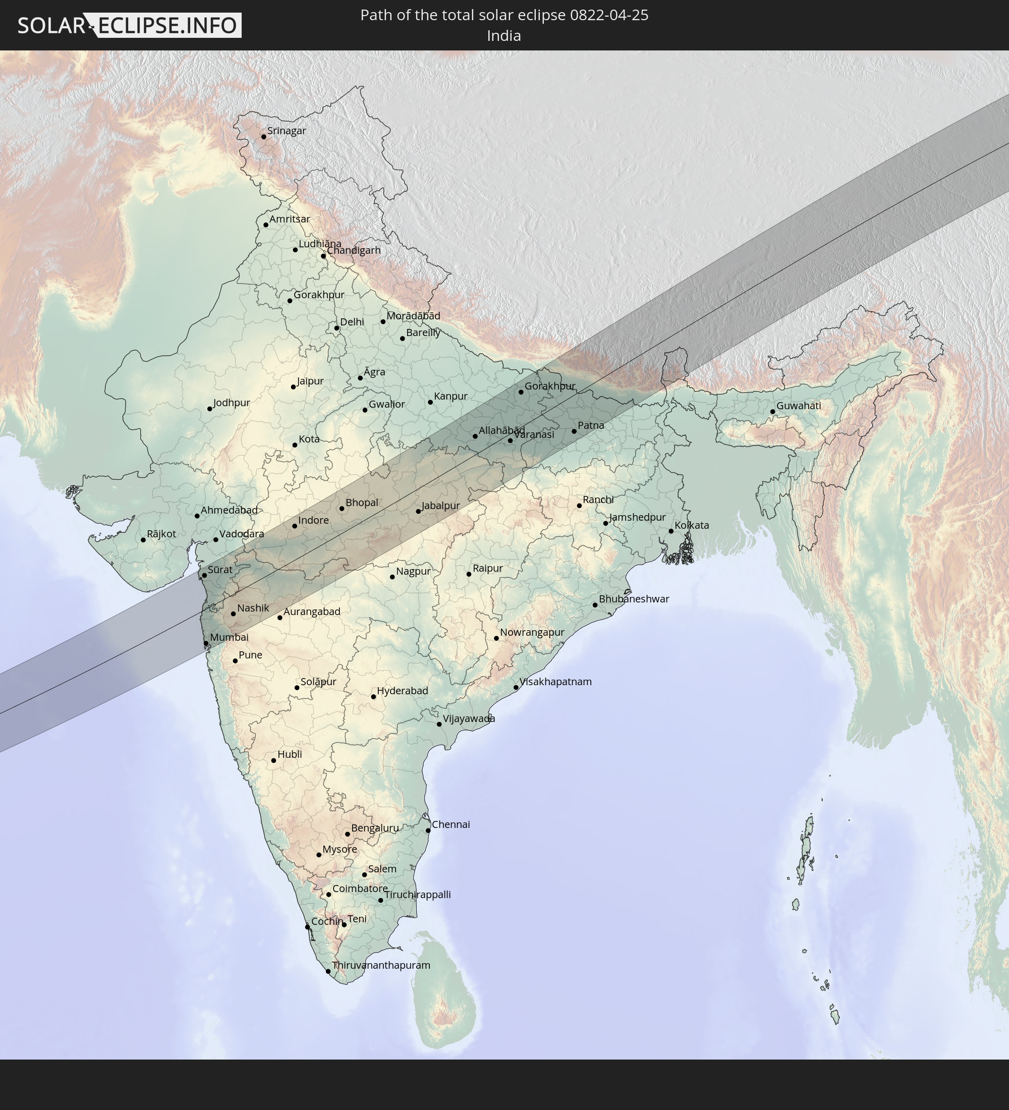 India
India
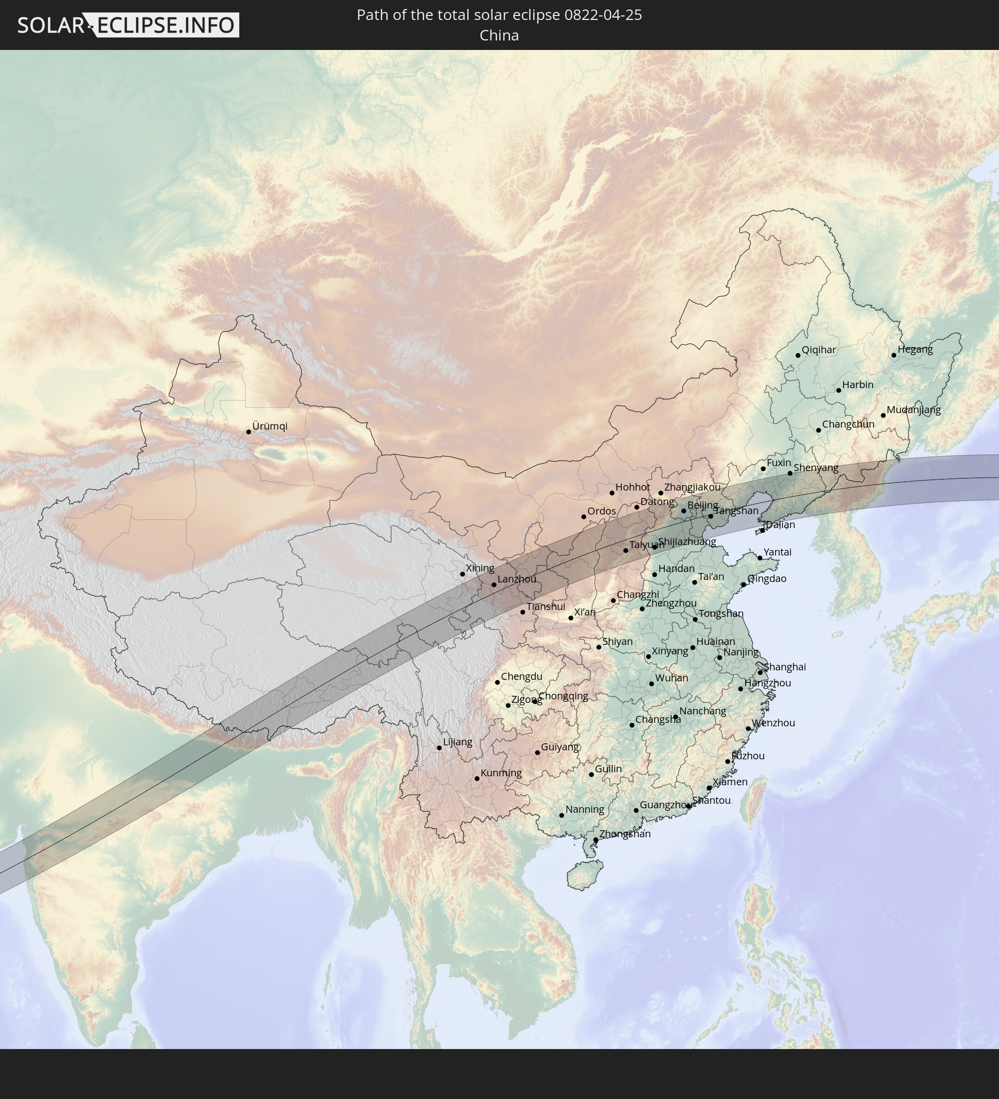 China
China
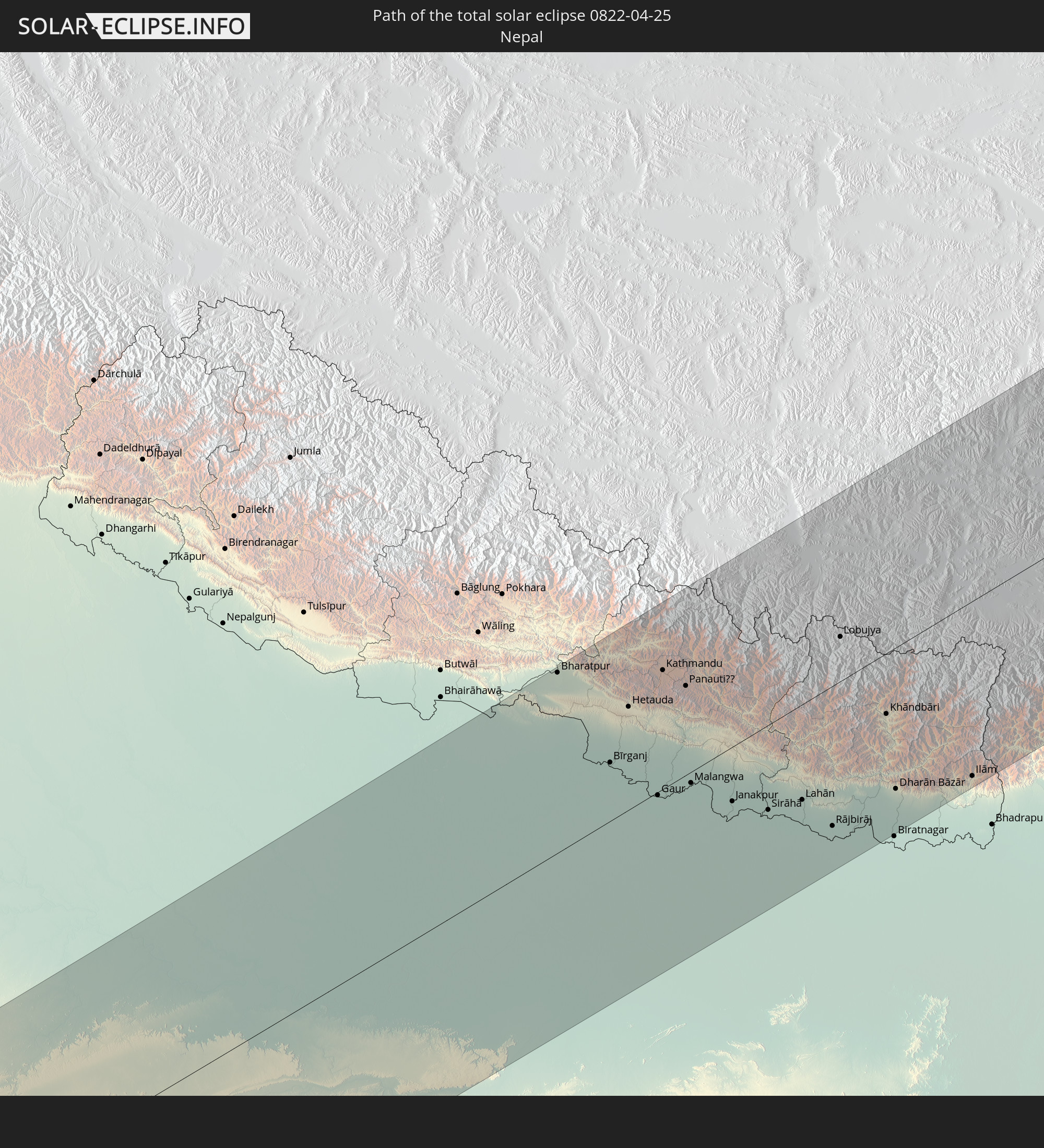 Nepal
Nepal
 Bhutan
 Japan
Japan
 North Korea
In den folgenden Ländern ist die Sonnenfinsternis partiell zu sehen
 Russia
 United States
 United States Minor Outlying Islands
 Canada
 Austria
 Czechia
 Slovenia
 Croatia
 Poland
 Bosnia and Herzegovina
 Hungary
 Slovakia
 Montenegro
 Serbia
 Albania
 Greece
 Romania
 Republic of Macedonia
 Sudan
Sudan
 Ukraine
 Bulgaria
 Belarus
 Egypt
Egypt
 Turkey
 Moldova
 Cyprus
 Ethiopia
 State of Palestine
 Israel
 Saudi Arabia
 Jordan
 Lebanon
 Syria
Syria
 Eritrea
 Iraq
Iraq
 Georgia
 French Southern and Antarctic Lands
 Somalia
 Djibouti
 Yemen
Yemen
 Armenia
 Iran
Iran
 Azerbaijan
 Seychelles
 Kazakhstan
 Kuwait
 Bahrain
 Qatar
Qatar
 United Arab Emirates
 Oman
Oman
 Turkmenistan
 Réunion
 Uzbekistan
 Mauritius
 Afghanistan
 Pakistan
 Tajikistan
 India
India
 Kyrgyzstan
 British Indian Ocean Territory
 Maldives
 China
China
 Sri Lanka
 Nepal
Nepal
 Mongolia
 Bangladesh
 Bhutan
 Myanmar
 Indonesia
 Thailand
 Malaysia
 Laos
Laos
 Vietnam
 Cambodia
 Singapore
 Macau
Macau
 Hong Kong
 Taiwan
 Philippines
 Japan
Japan
 North Korea
 South Korea
 Guam
Guam
 Northern Mariana Islands
 Marshall Islands
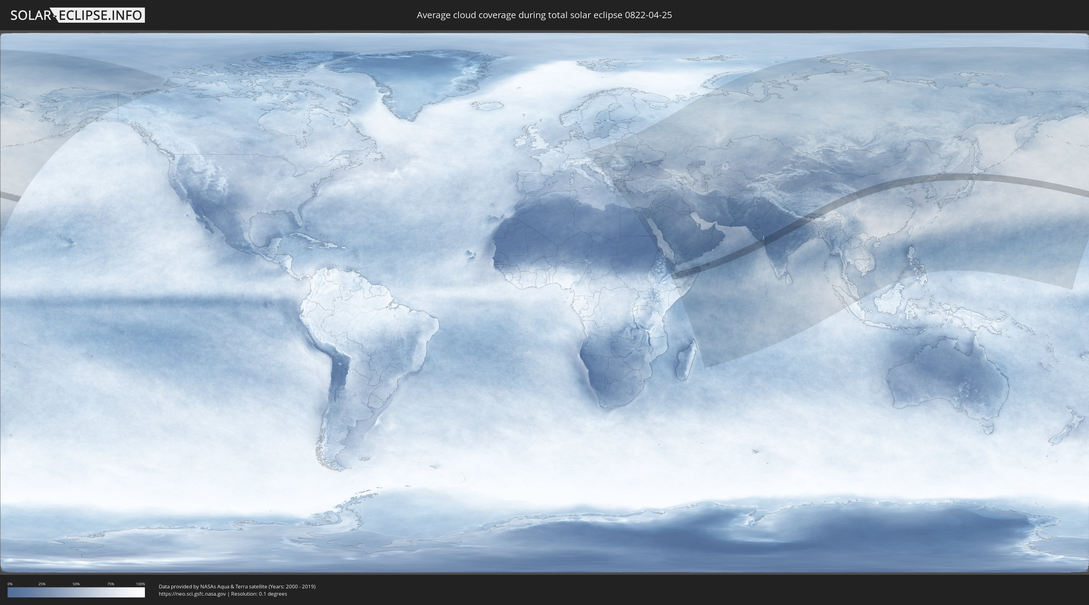
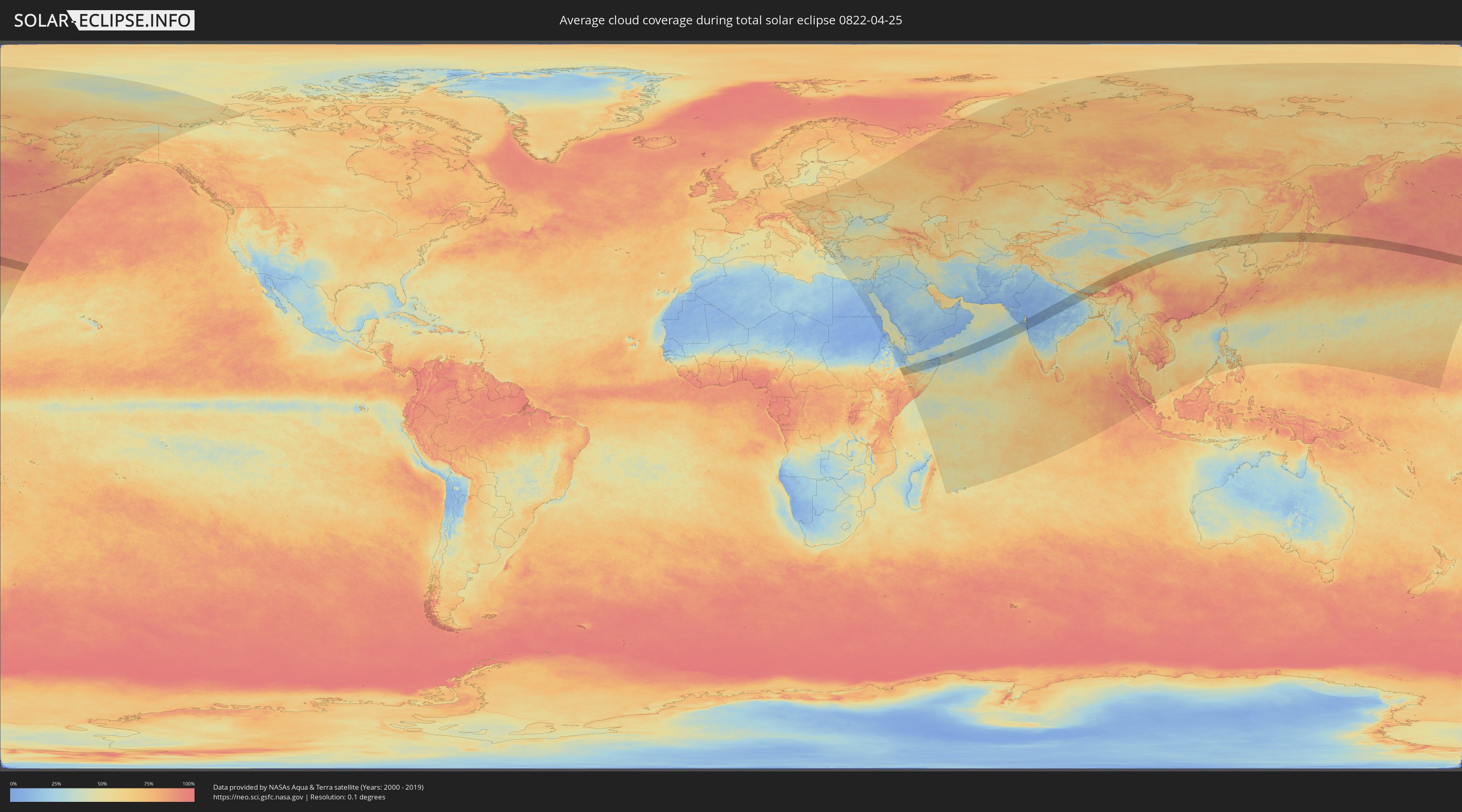
How will be the weather during the total solar eclipse on 04/25/0822?
Where is the best place to see the total solar eclipse of 04/25/0822?
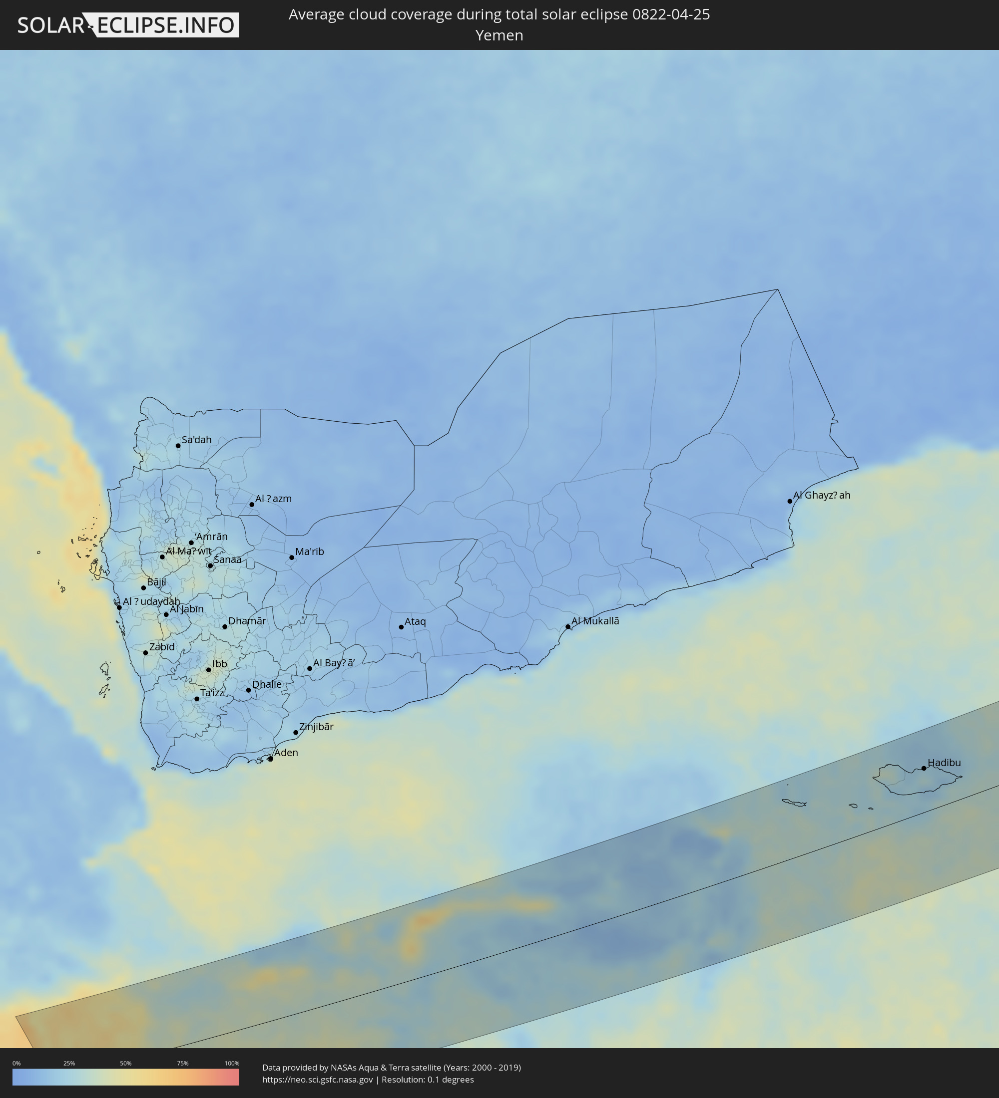
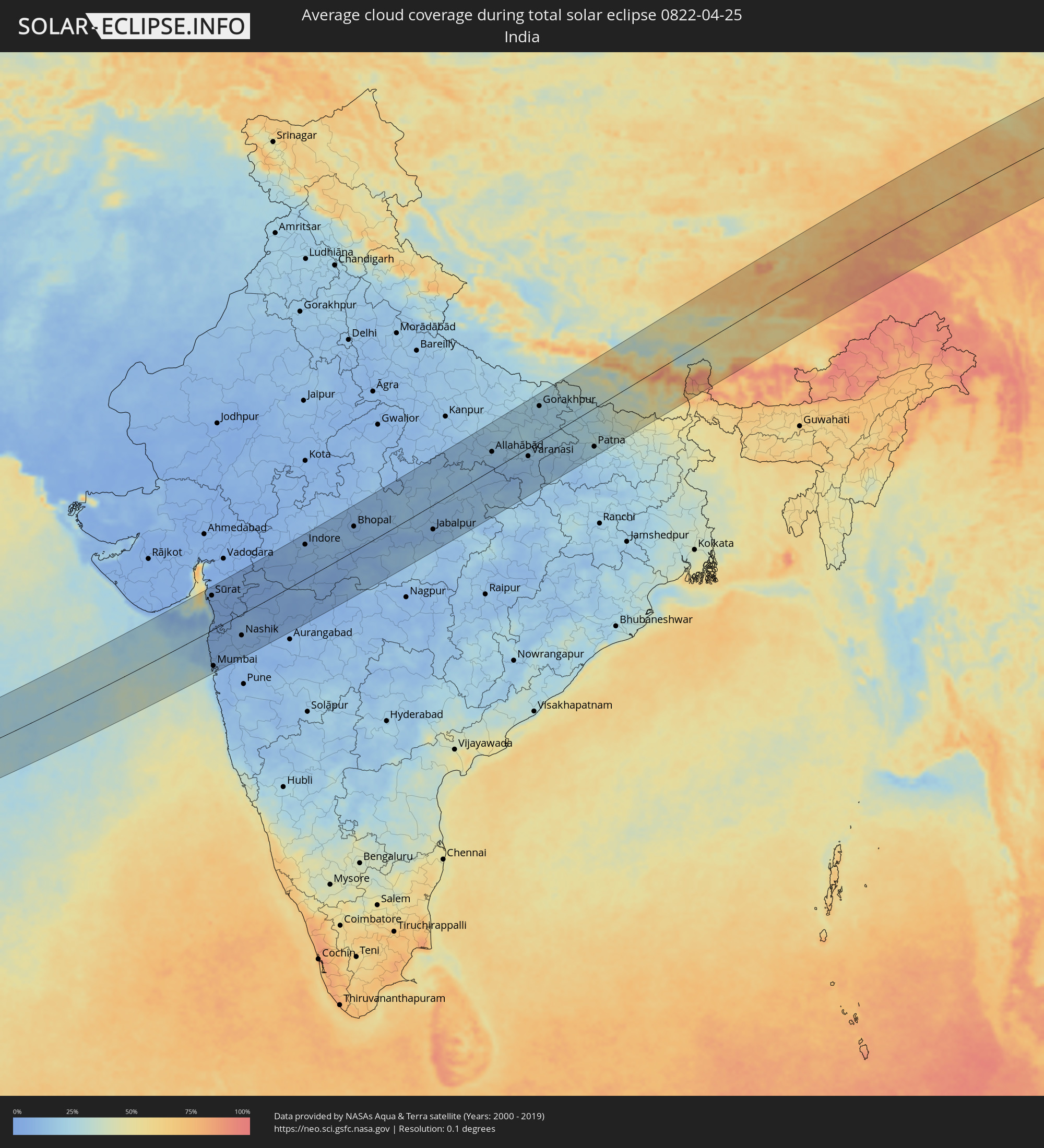
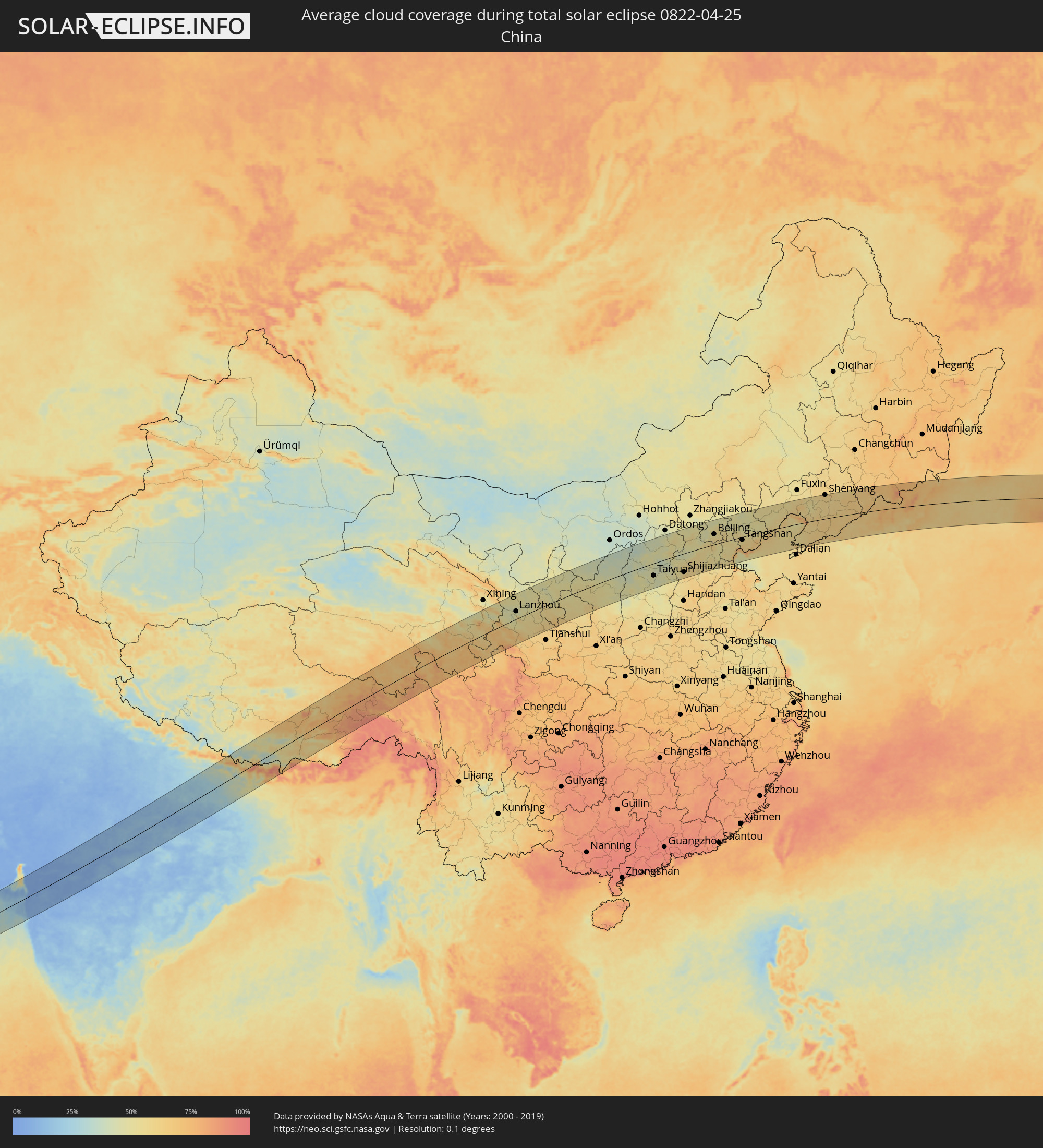
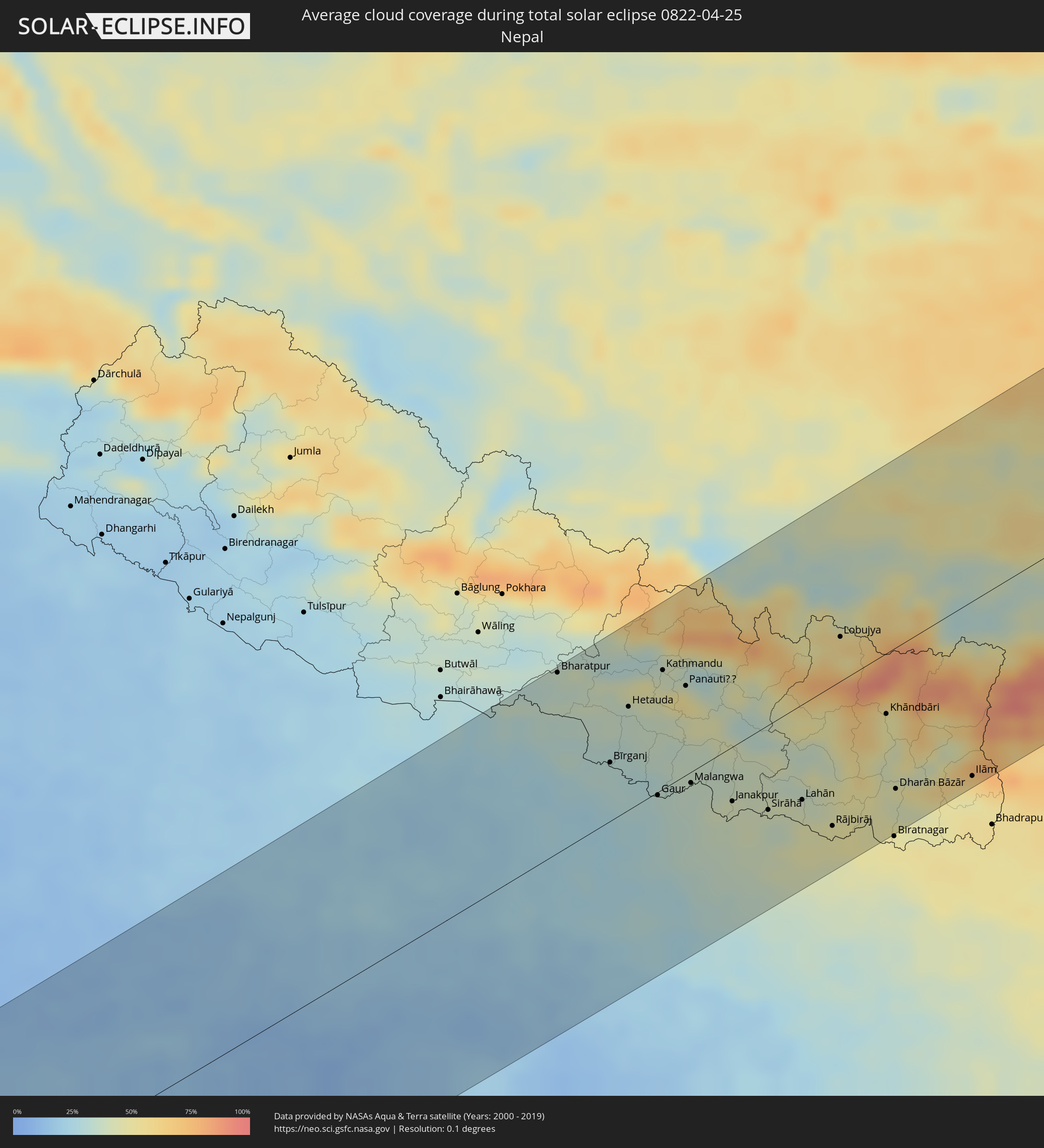
The following maps show the average cloud coverage for the day of the total solar eclipse.
With the help of these maps, it is possible to find the place along the eclipse path, which has the best
chance of a cloudless sky.
Nevertheless, you should consider local circumstances and inform about the weather of your chosen
observation site.
The data is provided by NASAs satellites
AQUA and TERRA.
The cloud maps are averaged over a period of 19 years (2000 - 2019).
Detailed country maps
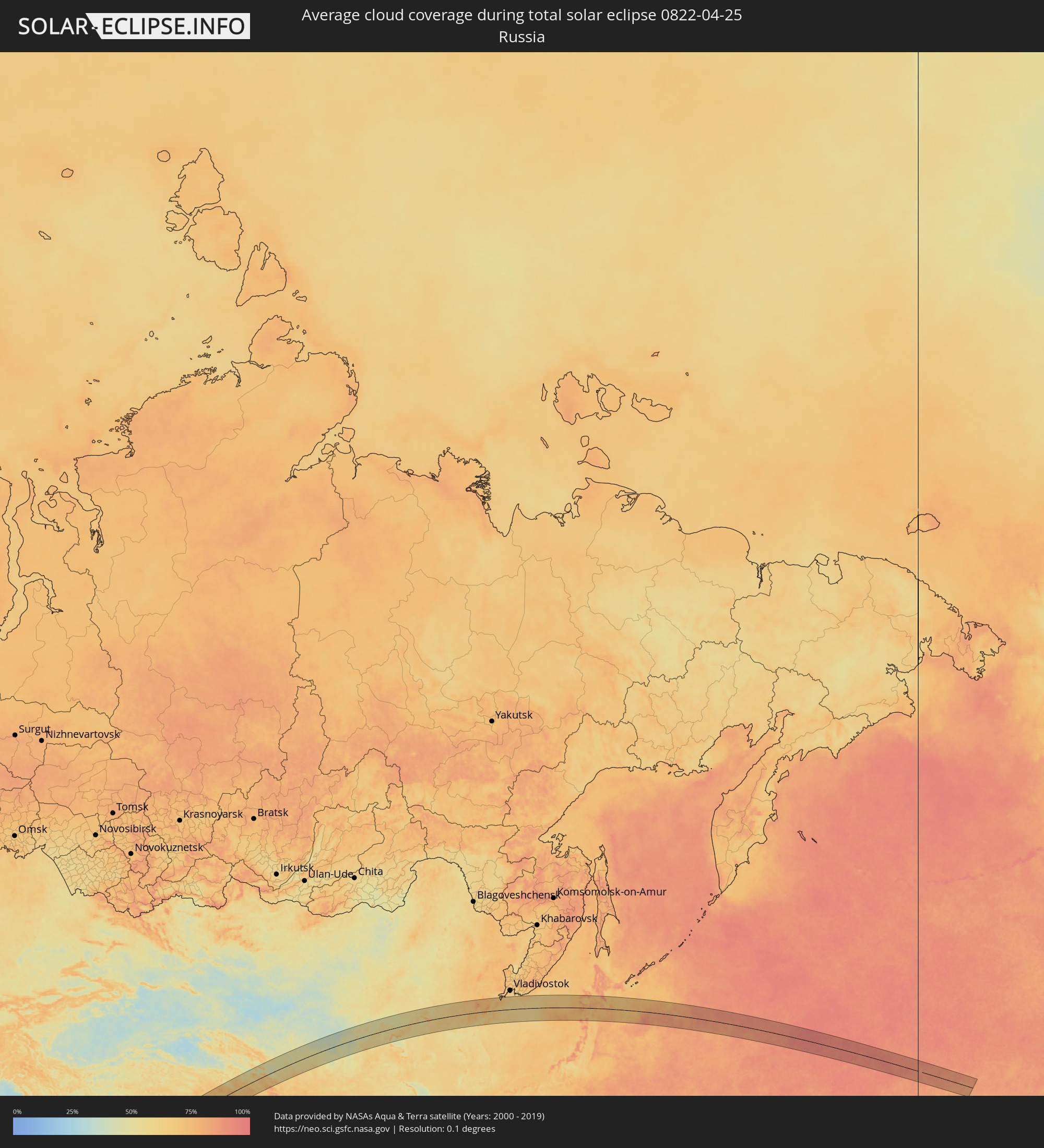 Russia
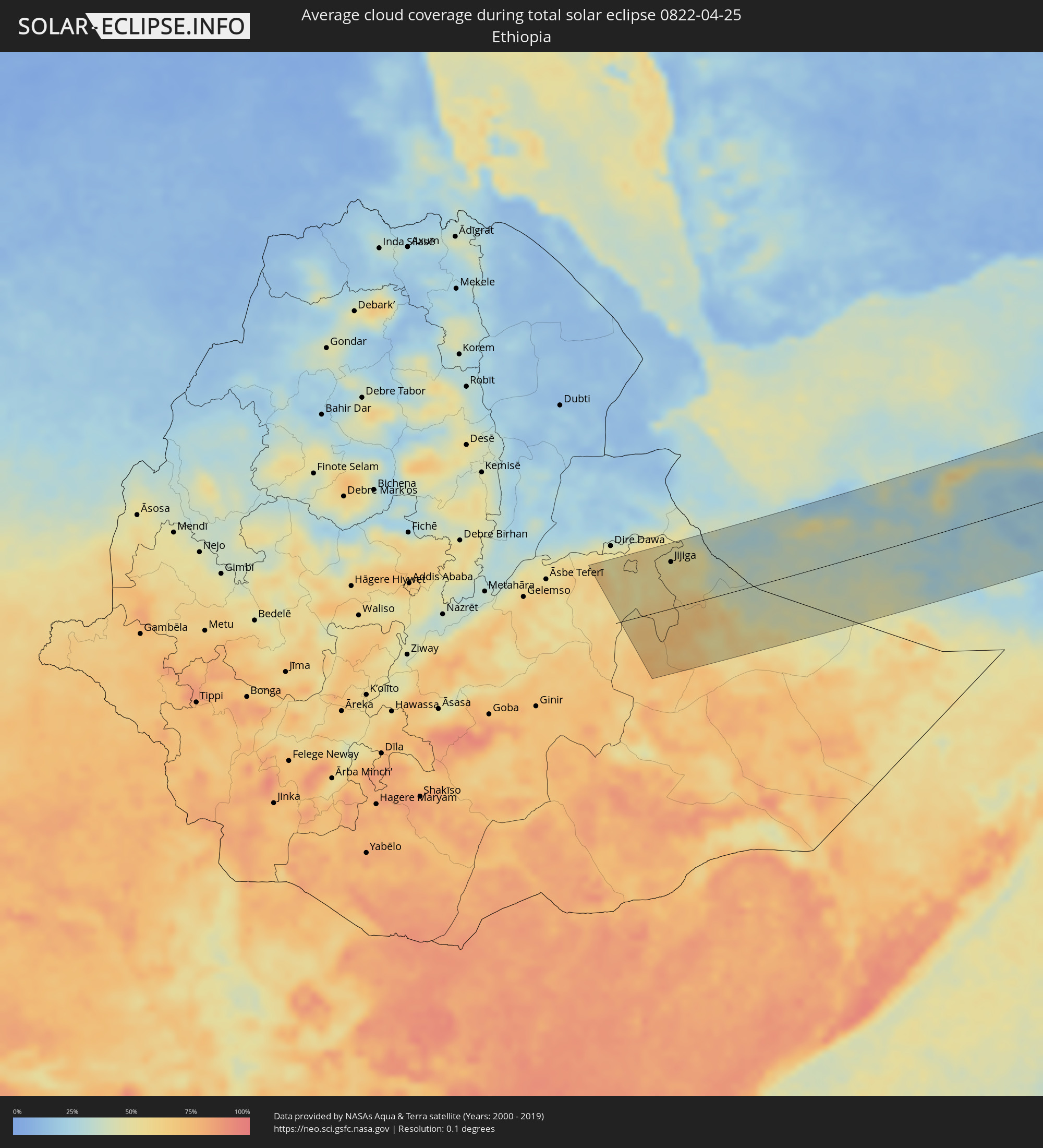 Ethiopia
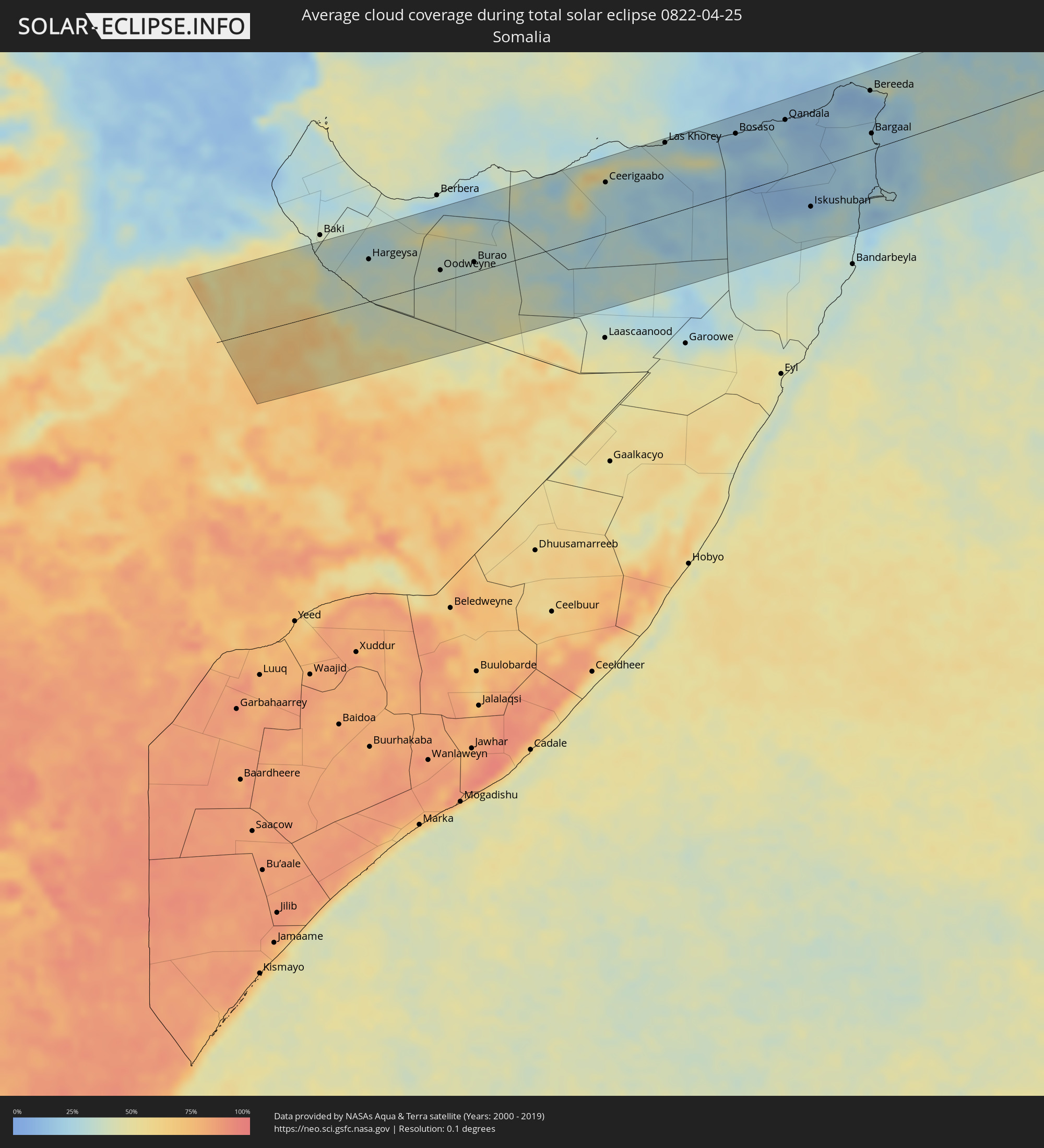 Somalia
 Yemen
Yemen
 India
India
 China
China
 Nepal
Nepal
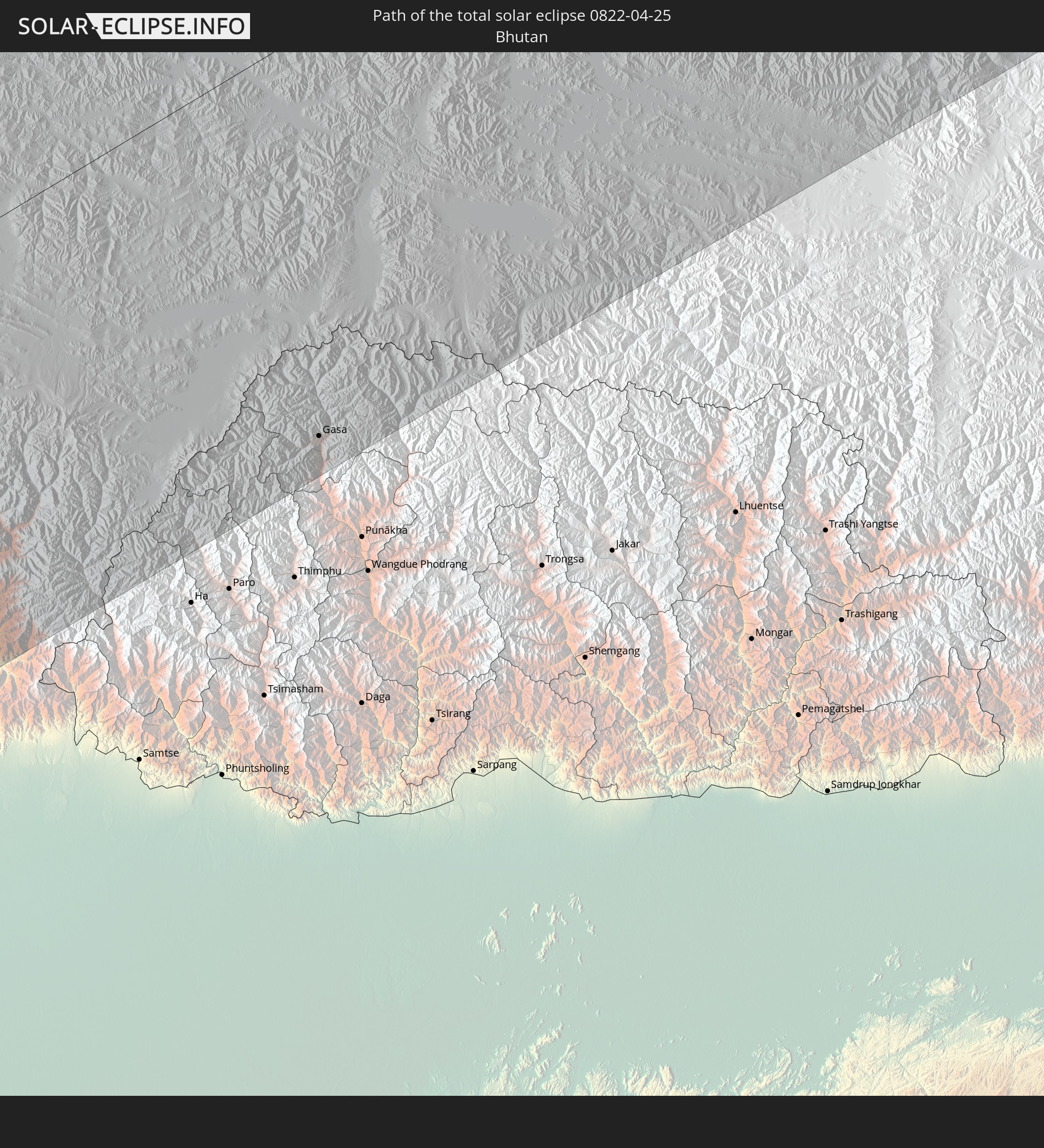
 Bhutan
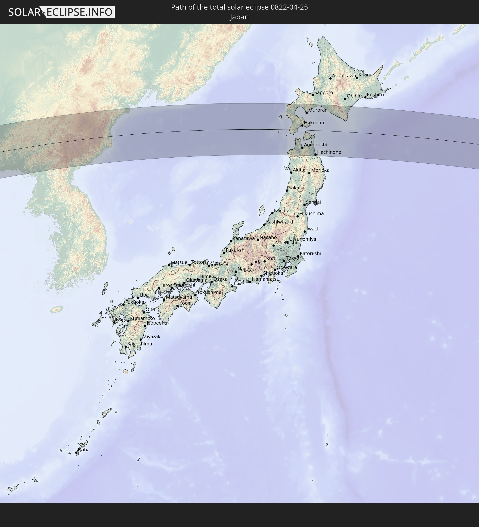
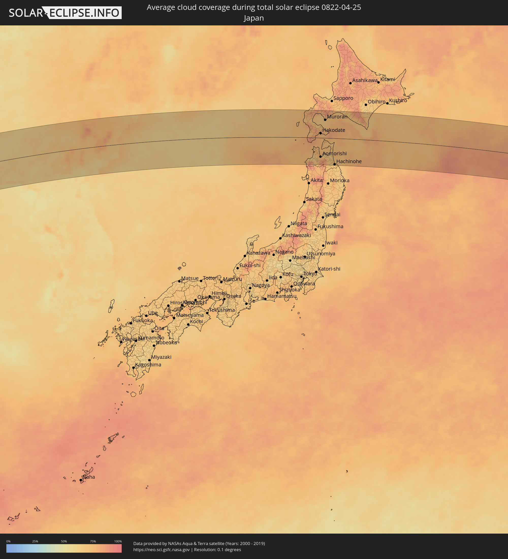 Japan
Japan
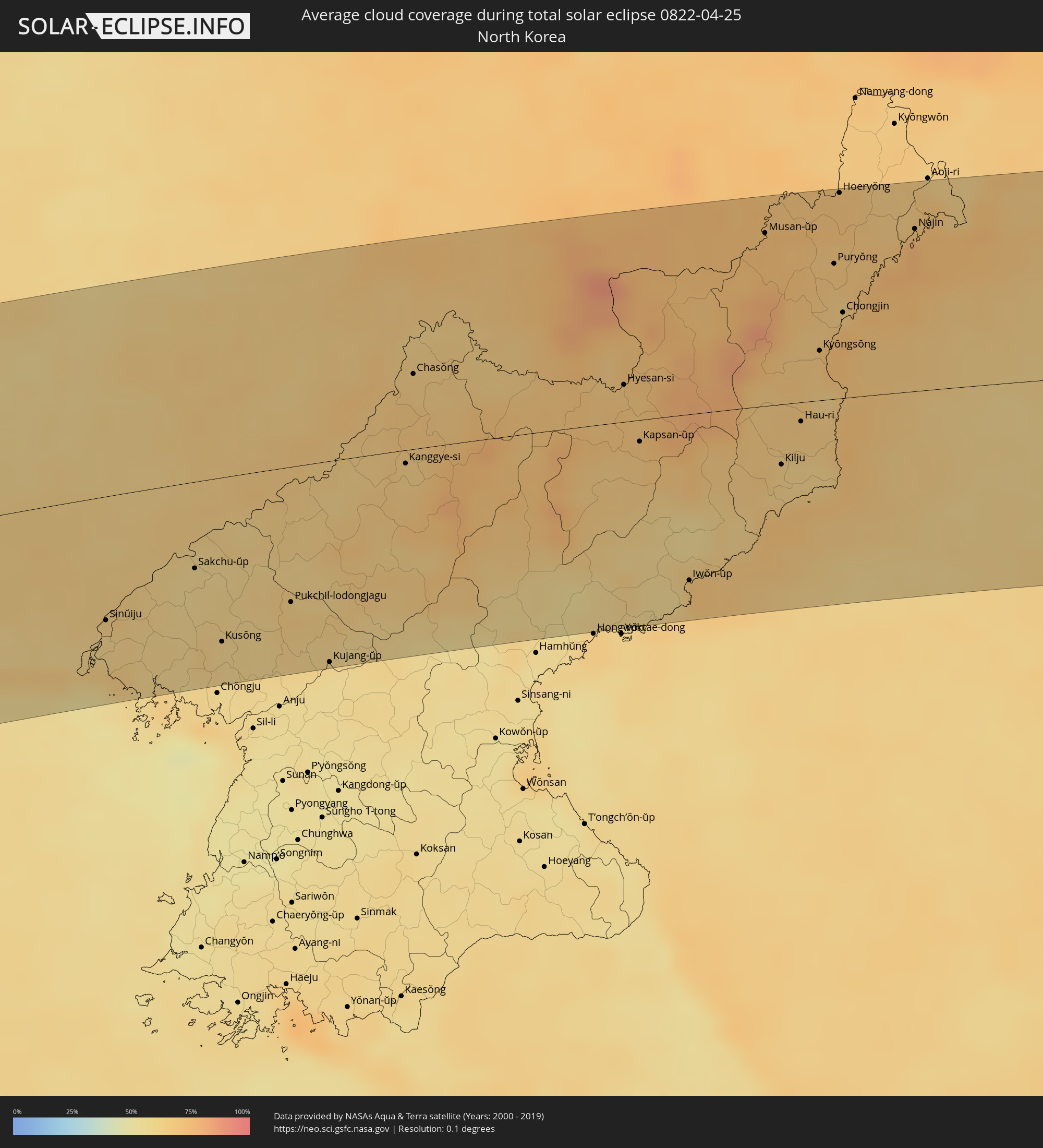 North Korea
Cities inside the path of the eclipse
The following table shows all locations with a population of more than 5,000 inside the eclipse path. Cities which have more than 100,000 inhabitants are marked bold. A click at the locations opens a detailed map.
| City | Type | Eclipse duration | Local time of max. eclipse | Distance to central line | Ø Cloud coverage |
|
Harar, Harari
|
total | - | 05:27:35 UTC+02:27 | 92 km | 58% |
|
Jijiga, Somali
|
total | - | 05:27:30 UTC+02:27 | 76 km | 49% |
|
Hargeysa, Woqooyi Galbeed
|
total | - | 05:27:28 UTC+02:27 | 62 km | 33% |
|
Oodweyne, Togdheer
|
total | - | 05:27:13 UTC+02:27 | 17 km | 36% |
|
Burao, Togdheer
|
total | - | 05:27:16 UTC+02:27 | 15 km | 35% |
|
Ceerigaabo, Sanaag
|
total | - | 05:28:04 UTC+02:27 | 74 km | 30% |
|
Las Khorey, Sanaag
|
total | - | 05:28:32 UTC+02:27 | 106 km | 28% |
|
Bosaso, Bari
|
total | - | 05:28:39 UTC+02:27 | 87 km | 15% |
|
Qandala, Bari
|
total | - | 05:28:50 UTC+02:27 | 83 km | 16% |
|
Iskushuban, Bari
|
total | - | 05:27:46 UTC+02:27 | 55 km | 18% |
|
Bereeda, Bari
|
total | - | 05:29:16 UTC+02:27 | 85 km | 15% |
|
Bargaal, Bari
|
total | - | 05:28:43 UTC+02:27 | 23 km | 26% |
|
Hadibu, Soqatra Governorate
|
total | - | 06:09:59 UTC+03:06 | 61 km | 29% |
|
Sūrat, Gujarat
|
total | - | 08:44:50 UTC+05:21 | 102 km | 5% |
|
Bhayandar, Maharashtra
|
total | - | 08:42:09 UTC+05:21 | 85 km | 9% |
|
Mumbai, Maharashtra
|
total | - | 08:41:52 UTC+05:21 | 109 km | 14% |
|
Bilimora, Gujarat
|
total | - | 08:44:21 UTC+05:21 | 54 km | 4% |
|
Thāne, Maharashtra
|
total | - | 08:42:06 UTC+05:21 | 100 km | 9% |
|
Kalyān, Maharashtra
|
total | - | 08:42:20 UTC+05:21 | 104 km | 8% |
|
Nashik, Maharashtra
|
total | - | 08:44:01 UTC+05:21 | 63 km | 8% |
|
Mālegaon, Maharashtra
|
total | - | 08:45:32 UTC+05:21 | 46 km | 6% |
|
Dhūlia, Maharashtra
|
total | - | 08:46:18 UTC+05:21 | 24 km | 5% |
|
Māndu, Madhya Pradesh
|
total | - | 08:49:05 UTC+05:21 | 87 km | 9% |
|
Jalgaon, Maharashtra
|
total | - | 08:47:15 UTC+05:21 | 54 km | 5% |
|
Indore, Madhya Pradesh
|
total | - | 08:50:05 UTC+05:21 | 99 km | 9% |
|
Dewas, Madhya Pradesh
|
total | - | 08:50:42 UTC+05:21 | 111 km | 8% |
|
Punāsa, Madhya Pradesh
|
total | - | 08:49:58 UTC+05:21 | 23 km | 8% |
|
Bhopal, Madhya Pradesh
|
total | - | 08:52:38 UTC+05:21 | 70 km | 9% |
|
Jabalpur, Madhya Pradesh
|
total | - | 08:55:33 UTC+05:21 | 70 km | 9% |
|
Satna, Madhya Pradesh
|
total | - | 08:58:52 UTC+05:21 | 20 km | 14% |
|
Allahābād, Uttar Pradesh
|
total | - | 09:01:34 UTC+05:21 | 50 km | 15% |
|
Varanasi, Uttar Pradesh
|
total | - | 09:02:58 UTC+05:21 | 23 km | 14% |
|
Gorakhpur, Uttar Pradesh
|
total | - | 09:05:46 UTC+05:21 | 97 km | 21% |
|
Bharatpur, Central Region
|
total | - | 09:28:51 UTC+05:41 | 129 km | 34% |
|
Bīrganj, Central Region
|
total | - | 09:28:27 UTC+05:41 | 42 km | 31% |
|
Hetauda, Central Region
|
total | - | 09:29:20 UTC+05:41 | 74 km | 35% |
|
Patna, Bihar
|
total | - | 09:06:29 UTC+05:21 | 106 km | 23% |
|
Kirtipur, Central Region
|
total | - | 09:30:06 UTC+05:41 | 85 km | 42% |
|
Gaur, Central Region
|
total | - | 09:28:39 UTC+05:41 | 2 km | 32% |
|
Pātan, Central Region
|
total | - | 09:30:09 UTC+05:41 | 83 km | 42% |
|
Kathmandu, Central Region
|
total | - | 09:30:12 UTC+05:41 | 85 km | 42% |
|
Muzaffarpur, Bihar
|
total | - | 09:07:42 UTC+05:21 | 69 km | 27% |
|
Hari Bdr Tamang House, Central Region
|
total | - | 09:30:18 UTC+05:41 | 71 km | 51% |
|
kankrabari Dovan, Central Region
|
total | - | 09:30:18 UTC+05:41 | 71 km | 51% |
|
Panauti̇̄, Central Region
|
total | - | 09:30:19 UTC+05:41 | 64 km | 51% |
|
Banepā, Central Region
|
total | - | 09:30:24 UTC+05:41 | 68 km | 51% |
|
Malangwa, Central Region
|
total | - | 09:29:13 UTC+05:41 | 8 km | 35% |
|
Jaleswar, Central Region
|
total | - | 09:29:16 UTC+05:41 | 40 km | 38% |
|
Darbhanga, Bihar
|
total | - | 09:08:31 UTC+05:21 | 92 km | 35% |
|
Janakpur, Central Region
|
total | - | 09:29:32 UTC+05:41 | 39 km | 40% |
|
Sirāhā, Eastern Region
|
total | - | 09:29:54 UTC+05:41 | 61 km | 41% |
|
Lahān, Eastern Region
|
total | - | 09:30:28 UTC+05:41 | 68 km | 42% |
|
Rājbirāj, Eastern Region
|
total | - | 09:30:33 UTC+05:41 | 100 km | 47% |
|
Lobujya, Eastern Region
|
total | - | 09:32:54 UTC+05:41 | 31 km | 56% |
|
Khāndbāri, Eastern Region
|
total | - | 09:32:36 UTC+05:41 | 43 km | 50% |
|
Ithari, Eastern Region
|
total | - | 09:31:36 UTC+05:41 | 115 km | 42% |
|
Dharān Bāzār, Eastern Region
|
total | - | 09:31:50 UTC+05:41 | 101 km | 43% |
|
Dhankutā, Eastern Region
|
total | - | 09:32:11 UTC+05:41 | 87 km | 43% |
|
Ilām, Eastern Region
|
total | - | 09:33:02 UTC+05:41 | 124 km | 55% |
|
Gasa, Gasa District
|
total | - | 09:54:55 UTC+05:58 | 121 km | 89% |
|
Lanzhou, Gansu
|
total | - | 12:34:29 UTC+08:00 | 40 km | 46% |
|
Taiyuan, Shanxi
|
total | - | 12:53:53 UTC+08:00 | 64 km | 45% |
|
Yangquan, Shanxi
|
total | - | 12:55:55 UTC+08:00 | 93 km | 48% |
|
Shijiazhuang, Hebei
|
total | - | 12:57:53 UTC+08:00 | 98 km | 62% |
|
Luancheng, Hebei
|
total | - | 12:58:09 UTC+08:00 | 120 km | 62% |
|
Baoding, Hebei
|
total | - | 13:00:19 UTC+08:00 | 38 km | 55% |
|
Beijing, Beijing
|
total | - | 13:02:33 UTC+08:00 | 54 km | 53% |
|
Langfang, Hebei
|
total | - | 13:02:58 UTC+08:00 | 4 km | 52% |
|
Cangzhou, Hebei
|
total | - | 13:02:50 UTC+08:00 | 128 km | 58% |
|
Tianjin, Tianjin
|
total | - | 13:03:46 UTC+08:00 | 46 km | 54% |
|
Tanggu, Tianjin
|
total | - | 13:04:39 UTC+08:00 | 70 km | 66% |
|
Tangshan, Hebei
|
total | - | 13:05:54 UTC+08:00 | 16 km | 56% |
|
Qinhuangdao, Hebei
|
total | - | 13:08:39 UTC+08:00 | 12 km | 64% |
|
Lianshan, Liaoning
|
total | - | 13:11:10 UTC+08:00 | 54 km | 59% |
|
Jinzhou, Liaoning
|
total | - | 13:11:44 UTC+08:00 | 87 km | 57% |
|
Panshan, Liaoning
|
total | - | 13:13:22 UTC+08:00 | 80 km | 61% |
|
Yingkou, Liaoning
|
total | - | 13:13:40 UTC+08:00 | 20 km | 73% |
|
Anshan, Liaoning
|
total | - | 13:15:03 UTC+08:00 | 58 km | 59% |
|
Liaoyang, Liaoning
|
total | - | 13:15:23 UTC+08:00 | 71 km | 59% |
|
Shenyang, Liaoning
|
total | - | 13:15:50 UTC+08:00 | 124 km | 63% |
|
Benxi, Liaoning
|
total | - | 13:16:25 UTC+08:00 | 64 km | 59% |
|
Fushun, Liaoning
|
total | - | 13:16:41 UTC+08:00 | 124 km | 63% |
|
Dandong, Liaoning
|
total | - | 13:17:34 UTC+08:00 | 72 km | 62% |
|
Sinŭiju, P'yŏngan-bukto
|
total | - | 13:40:34 UTC+08:23 | 75 km | 62% |
|
Ŭiju, P'yŏngan-bukto
|
total | - | 13:40:49 UTC+08:23 | 66 km | 66% |
|
Sakchu-ŭp, P'yŏngan-bukto
|
total | - | 13:41:43 UTC+08:23 | 53 km | 59% |
|
Kusŏng, P'yŏngan-bukto
|
total | - | 13:42:06 UTC+08:23 | 100 km | 62% |
|
Pukchil-lodongjagu, P'yŏngan-bukto
|
total | - | 13:42:59 UTC+08:23 | 82 km | 65% |
|
Kujang-ŭp, P'yŏngan-bukto
|
total | - | 13:43:30 UTC+08:23 | 123 km | 58% |
|
Kanggye-si, Chagang-do
|
total | - | 13:44:20 UTC+08:23 | 8 km | 64% |
|
Chasŏng, Chagang-do
|
total | - | 13:44:22 UTC+08:23 | 45 km | 65% |
|
Yŏnggwang-ŭp, Hamgyŏng-namdo
|
total | - | 13:45:59 UTC+08:23 | 123 km | 58% |
|
Hyesan-si, Yanggang-do
|
total | - | 13:46:56 UTC+08:23 | 22 km | 68% |
|
Kapsan-ŭp, Yanggang-do
|
total | - | 13:47:12 UTC+08:23 | 13 km | 68% |
|
Iwŏn-ŭp, Hamgyŏng-namdo
|
total | - | 13:47:58 UTC+08:23 | 101 km | 70% |
|
Musan-ŭp, Hamgyŏng-bukto
|
total | - | 13:48:23 UTC+08:23 | 104 km | 73% |
|
Kilju, Hamgyŏng-bukto
|
total | - | 13:48:56 UTC+08:23 | 37 km | 64% |
|
Hau-ri, Hamgyŏng-bukto
|
total | - | 13:49:06 UTC+08:23 | 12 km | 67% |
|
Kyŏngsŏng, Hamgyŏng-bukto
|
total | - | 13:49:12 UTC+08:23 | 30 km | 67% |
|
Nanam, Hamgyŏng-bukto
|
total | - | 13:49:17 UTC+08:23 | 43 km | 73% |
|
Komusan 1-tong, Hamgyŏng-bukto
|
total | - | 13:49:12 UTC+08:23 | 87 km | 68% |
|
Puryŏng, Hamgyŏng-bukto
|
total | - | 13:49:14 UTC+08:23 | 82 km | 68% |
|
Hoeryŏng, Hamgyŏng-bukto
|
total | - | 13:49:10 UTC+08:23 | 124 km | 71% |
|
Chongjin, Hamgyŏng-bukto
|
total | - | 13:49:25 UTC+08:23 | 52 km | 73% |
|
Najin, Rason
|
total | - | 13:50:05 UTC+08:23 | 98 km | 77% |
|
Sŏnbong, Rason
|
total | - | 13:50:13 UTC+08:23 | 107 km | 73% |
|
Shimokizukuri, Aomori
|
total | - | 14:42:08 UTC+09:00 | 87 km | 67% |
|
Goshogawara, Aomori
|
total | - | 14:42:13 UTC+09:00 | 89 km | 67% |
|
Hirosaki, Aomori
|
total | - | 14:42:24 UTC+09:00 | 112 km | 71% |
|
Kuroishi, Aomori
|
total | - | 14:42:30 UTC+09:00 | 106 km | 73% |
|
Namioka, Aomori
|
total | - | 14:42:28 UTC+09:00 | 99 km | 72% |
|
Kamiiso, Hokkaido
|
total | - | 14:41:47 UTC+09:00 | 25 km | 79% |
|
Nanae, Hokkaido
|
total | - | 14:41:48 UTC+09:00 | 32 km | 76% |
|
Aomorishi, Aomori
|
total | - | 14:42:35 UTC+09:00 | 86 km | 76% |
|
Hakodate, Hokkaido
|
total | - | 14:41:56 UTC+09:00 | 20 km | 76% |
|
Date, Hokkaido
|
total | - | 14:41:37 UTC+09:00 | 98 km | 69% |
|
Muroran, Hokkaido
|
total | - | 14:41:52 UTC+09:00 | 81 km | 65% |
|
Mutsu, Aomori
|
total | - | 14:42:51 UTC+09:00 | 33 km | 72% |
|
Shiraoi, Hokkaido
|
total | - | 14:42:08 UTC+09:00 | 108 km | 72% |
|
Misawa, Aomori
|
total | - | 14:43:29 UTC+09:00 | 99 km | 68% |
|
Hachinohe, Aomori
|
total | - | 14:43:45 UTC+09:00 | 120 km | 67% |
|
Tomakomai, Hokkaido
|
total | - | 14:42:22 UTC+09:00 | 119 km | 73% |
|
Shizunai-furukawachō, Hokkaido
|
total | - | 14:43:29 UTC+09:00 | 88 km | 73% |