Total solar eclipse of 06/18/0931
| Day of week: | Monday |
| Maximum duration of eclipse: | 03m06s |
| Maximum width of eclipse path: | 108 km |
| Saros cycle: | 100 |
| Coverage: | 100% |
| Magnitude: | 1.0318 |
| Gamma: | 0.0633 |
Wo kann man die Sonnenfinsternis vom 06/18/0931 sehen?
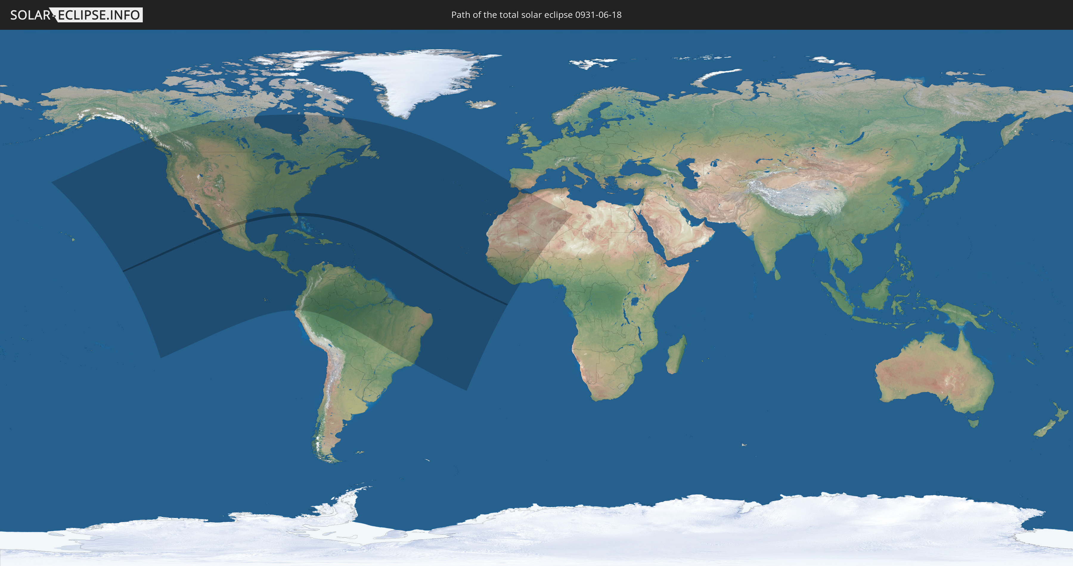
Die Sonnenfinsternis am 06/18/0931 kann man in 67 Ländern als partielle Sonnenfinsternis beobachten.
Der Finsternispfad verläuft durch 2 Länder. Nur in diesen Ländern ist sie als total Sonnenfinsternis zu sehen.
In den folgenden Ländern ist die Sonnenfinsternis total zu sehen
 United States
 Mexico
In den folgenden Ländern ist die Sonnenfinsternis partiell zu sehen
 United States
 United States Minor Outlying Islands
 Canada
 Mexico
 Greenland
 Guatemala
 Ecuador
 El Salvador
 Honduras
 Belize
 Nicaragua
 Costa Rica
 Cuba
Cuba
 Panama
 Colombia
 Cayman Islands
 Peru
Peru
 The Bahamas
 Jamaica
 Haiti
Haiti
 Brazil
 Venezuela
 Turks and Caicos Islands
 Dominican Republic
 Aruba
Aruba
 Puerto Rico
 United States Virgin Islands
 Bermuda
 British Virgin Islands
 Anguilla
 Collectivity of Saint Martin
 Saint Barthélemy
 Saint Kitts and Nevis
 Antigua and Barbuda
 Montserrat
 Trinidad and Tobago
 Guadeloupe
 Grenada
 Dominica
 Saint Vincent and the Grenadines
 Guyana
 Martinique
 Saint Lucia
 Barbados
 Suriname
 Saint Pierre and Miquelon
 French Guiana
 Portugal
 Cabo Verde
 Spain
Spain
 Senegal
 Mauritania
 The Gambia
 Guinea-Bissau
 Guinea
 Saint Helena, Ascension and Tristan da Cunha
 Sierra Leone
 Morocco
 Mali
Mali
 Liberia
 Algeria
 Ivory Coast
 Burkina Faso
 Gibraltar
 Ghana
Ghana
 Niger
Niger
 Libya
Libya
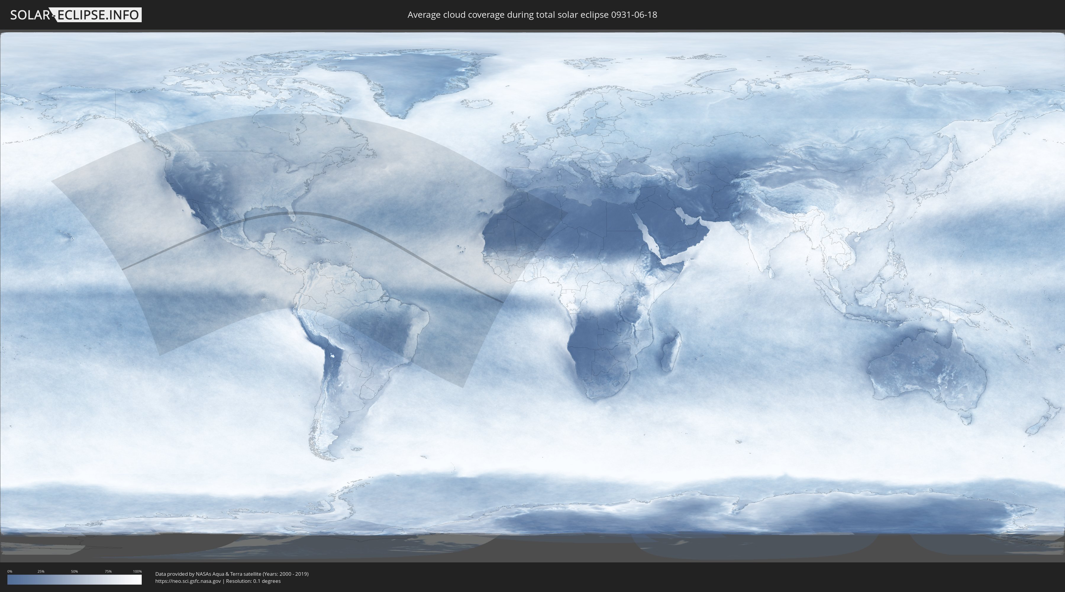
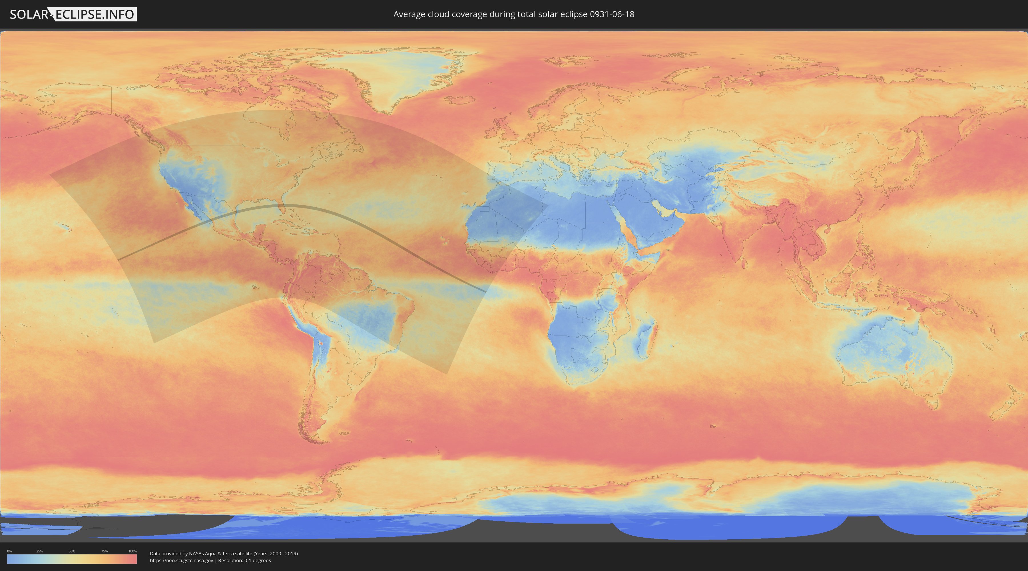
How will be the weather during the total solar eclipse on 06/18/0931?
Where is the best place to see the total solar eclipse of 06/18/0931?
The following maps show the average cloud coverage for the day of the total solar eclipse.
With the help of these maps, it is possible to find the place along the eclipse path, which has the best
chance of a cloudless sky.
Nevertheless, you should consider local circumstances and inform about the weather of your chosen
observation site.
The data is provided by NASAs satellites
AQUA and TERRA.
The cloud maps are averaged over a period of 19 years (2000 - 2019).
Detailed country maps
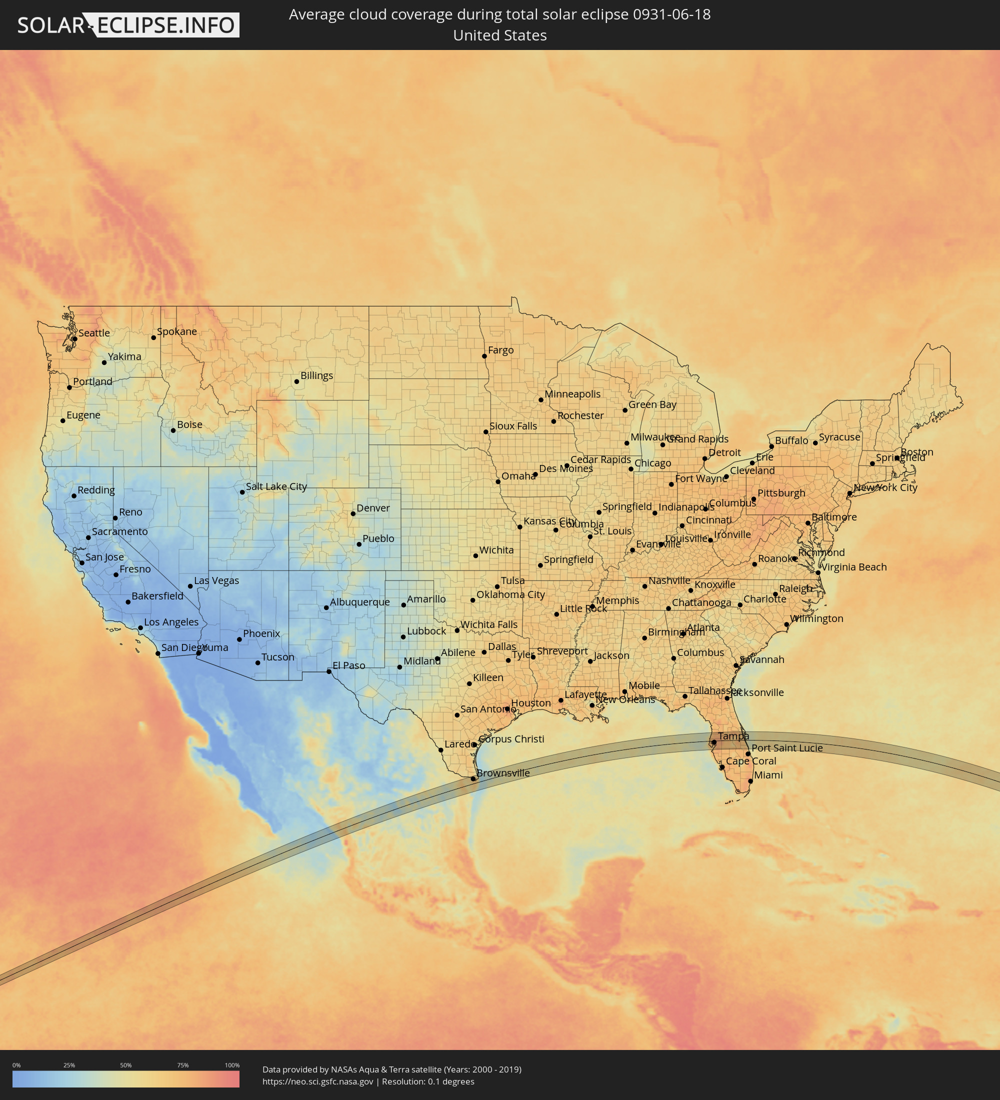 United States
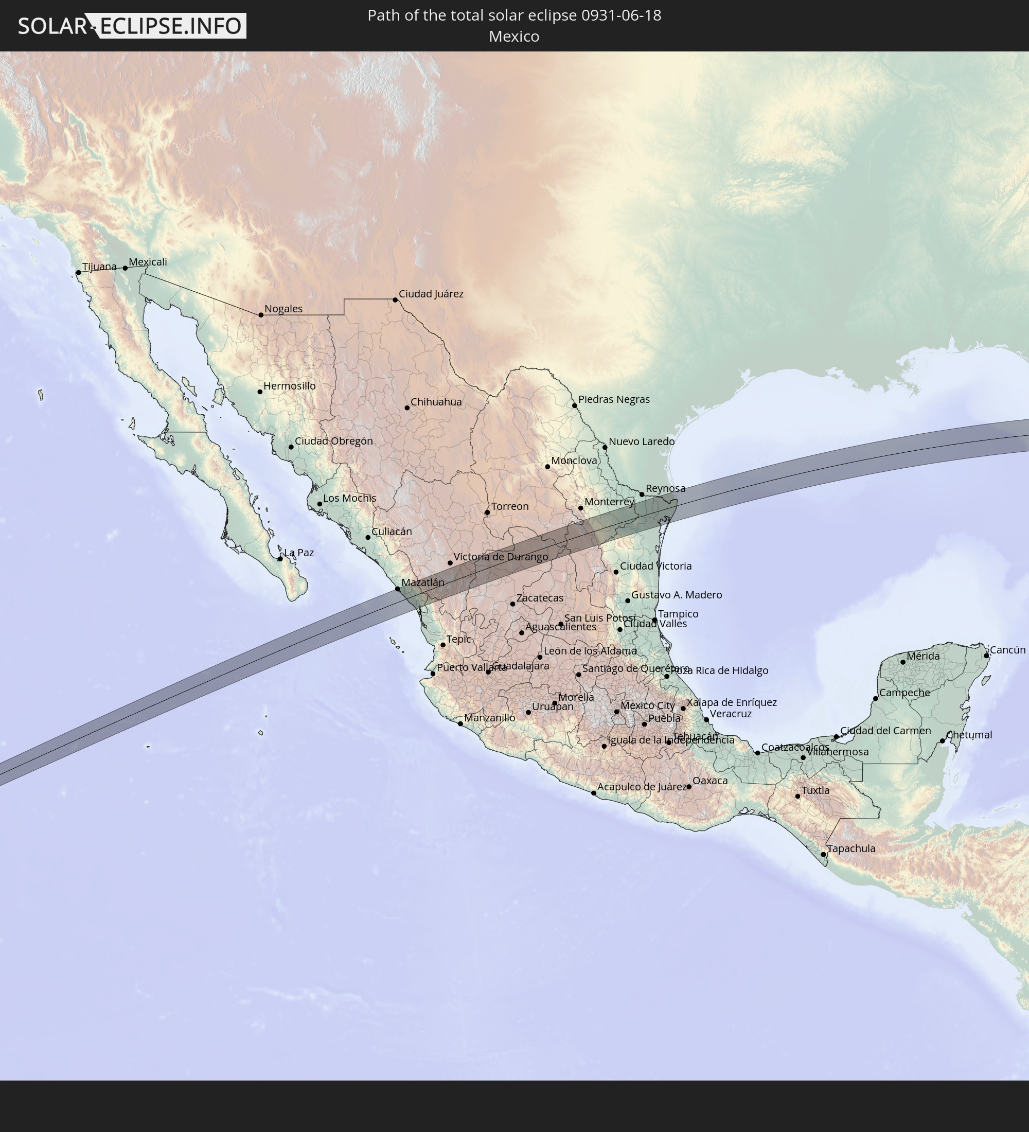
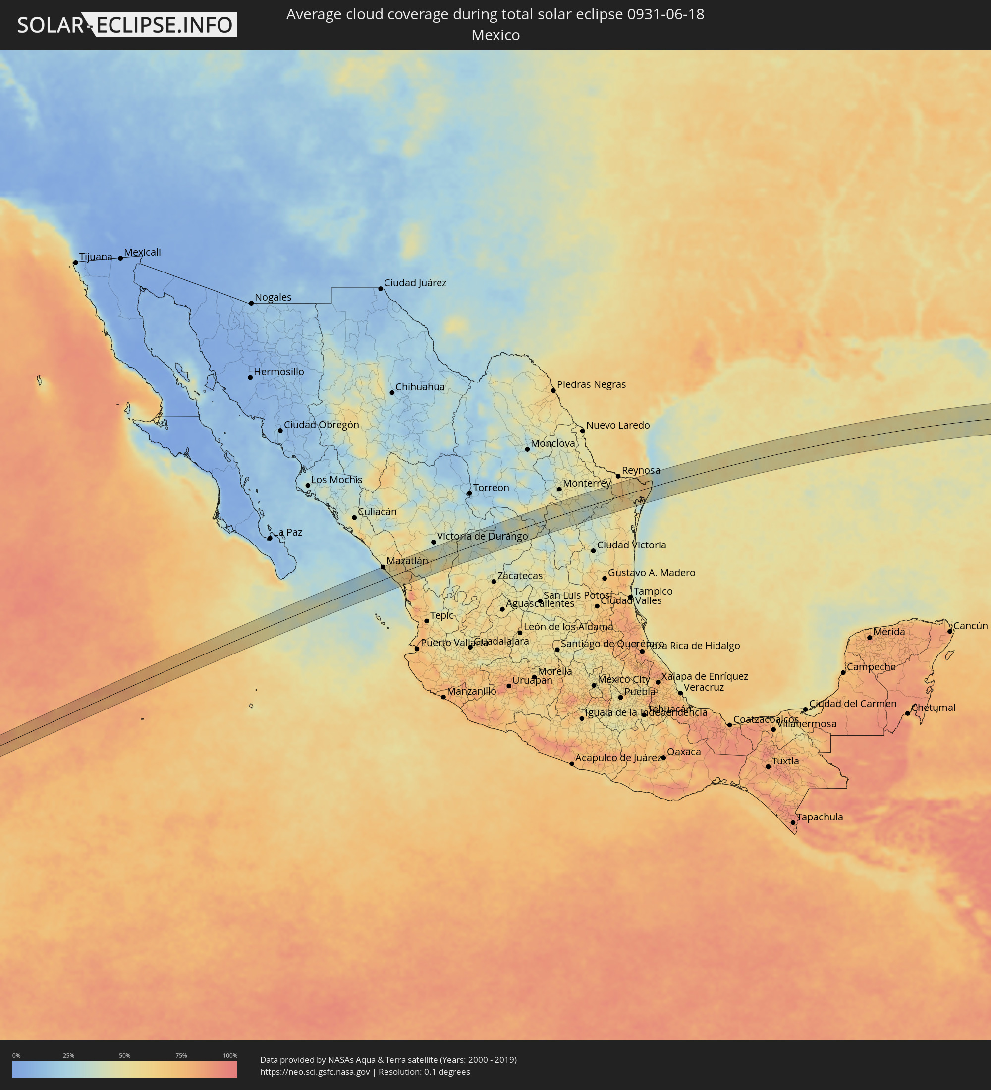 Mexico
Cities inside the path of the eclipse
The following table shows all locations with a population of more than 5,000 inside the eclipse path. Cities which have more than 100,000 inhabitants are marked bold. A click at the locations opens a detailed map.
| City | Type | Eclipse duration | Local time of max. eclipse | Distance to central line | Ø Cloud coverage |
|
Mazatlán, Sinaloa
|
total | - | 08:18:28 UTC-07:05 | 40 km | 35% |
|
Fraccionamiento los Ángeles, Sinaloa
|
total | - | 08:18:31 UTC-07:05 | 32 km | 44% |
|
Villa Unión, Sinaloa
|
total | - | 08:18:40 UTC-07:05 | 28 km | 49% |
|
Concordia, Sinaloa
|
total | - | 08:18:57 UTC-07:05 | 33 km | 55% |
|
Isla del Bosque, Sinaloa
|
total | - | 08:18:44 UTC-07:05 | 33 km | 53% |
|
Escuinapa de Hidalgo, Sinaloa
|
total | - | 08:18:55 UTC-07:05 | 25 km | 54% |
|
Pueblo Nuevo, Durango
|
total | - | 08:49:00 UTC-06:36 | 17 km | 54% |
|
Vicente Guerrero, Durango
|
total | - | 08:51:16 UTC-06:36 | 4 km | 44% |
|
Sombrerete, Zacatecas
|
total | - | 08:51:40 UTC-06:36 | 19 km | 37% |
|
Miguel Auza, Zacatecas
|
total | - | 08:52:33 UTC-06:36 | 44 km | 35% |
|
Juan Aldama, Zacatecas
|
total | - | 08:52:38 UTC-06:36 | 41 km | 35% |
|
Río Grande, Zacatecas
|
total | - | 08:52:45 UTC-06:36 | 20 km | 38% |
|
Nieves, Zacatecas
|
total | - | 08:52:55 UTC-06:36 | 3 km | 37% |
|
Concepcion del Oro, Zacatecas
|
total | - | 08:55:56 UTC-06:36 | 8 km | 42% |
|
Galeana, Nuevo León
|
total | - | 08:58:19 UTC-06:36 | 13 km | 41% |
|
Allende, Nuevo León
|
total | - | 08:58:49 UTC-06:36 | 33 km | 50% |
|
Montemorelos, Nuevo León
|
total | - | 08:59:03 UTC-06:36 | 18 km | 42% |
|
General Teran, Nuevo León
|
total | - | 08:59:22 UTC-06:36 | 21 km | 41% |
|
Hualahuises, Nuevo León
|
total | - | 08:59:03 UTC-06:36 | 19 km | 37% |
|
Linares, Nuevo León
|
total | - | 08:59:12 UTC-06:36 | 25 km | 37% |
|
La Reforma, Nuevo León
|
total | - | 08:59:07 UTC-06:36 | 43 km | 36% |
|
Valle Hermoso, Tamaulipas
|
total | - | 09:03:00 UTC-06:36 | 9 km | 51% |
|
Heroica Matamoros, Tamaulipas
|
total | - | 09:03:45 UTC-06:36 | 22 km | 68% |
|
Brownsville, Texas
|
total | - | 09:40:22 UTC-06:00 | 24 km | 68% |
|
Cameron Park Colonia, Texas
|
total | - | 09:40:28 UTC-06:00 | 31 km | 67% |
|
Cameron Park, Texas
|
total | - | 09:40:28 UTC-06:00 | 30 km | 67% |
|
Clearwater, Florida
|
total | - | 11:15:01 UTC-05:00 | 8 km | 72% |
|
Seminole, Florida
|
total | - | 11:15:01 UTC-05:00 | 22 km | 64% |
|
Treasure Island, Florida
|
total | - | 11:15:03 UTC-05:00 | 30 km | 64% |
|
Beacon Square, Florida
|
total | - | 11:15:11 UTC-05:00 | 19 km | 67% |
|
Saint Pete Beach, Florida
|
total | - | 11:15:07 UTC-05:00 | 35 km | 68% |
|
Holiday, Florida
|
total | - | 11:15:13 UTC-05:00 | 17 km | 74% |
|
Elfers, Florida
|
total | - | 11:15:16 UTC-05:00 | 20 km | 74% |
|
New Port Richey, Florida
|
total | - | 11:15:17 UTC-05:00 | 23 km | 74% |
|
Gulfport, Florida
|
total | - | 11:15:13 UTC-05:00 | 32 km | 68% |
|
East Lake, Florida
|
total | - | 11:15:19 UTC-05:00 | 8 km | 75% |
|
Hudson, Florida
|
total | - | 11:15:23 UTC-05:00 | 36 km | 68% |
|
Safety Harbor, Florida
|
total | - | 11:15:18 UTC-05:00 | 6 km | 72% |
|
New Port Richey East, Florida
|
total | - | 11:15:21 UTC-05:00 | 24 km | 75% |
|
Jasmine Estates, Florida
|
total | - | 11:15:22 UTC-05:00 | 28 km | 75% |
|
West and East Lealman, Florida
|
total | - | 11:15:16 UTC-05:00 | 25 km | 70% |
|
Bayonet Point, Florida
|
total | - | 11:15:24 UTC-05:00 | 32 km | 75% |
|
Trinity, Florida
|
total | - | 11:15:22 UTC-05:00 | 16 km | 74% |
|
Lealman, Florida
|
total | - | 11:15:18 UTC-05:00 | 24 km | 70% |
|
St. Petersburg, Florida
|
total | - | 11:15:18 UTC-05:00 | 30 km | 70% |
|
Oldsmar, Florida
|
total | - | 11:15:23 UTC-05:00 | 1 km | 72% |
|
Westchase, Florida
|
total | - | 11:15:32 UTC-05:00 | 1 km | 79% |
|
Odessa, Florida
|
total | - | 11:15:36 UTC-05:00 | 17 km | 76% |
|
Shady Hills, Florida
|
total | - | 11:15:47 UTC-05:00 | 40 km | 78% |
|
Greater Northdale, Florida
|
total | - | 11:15:46 UTC-05:00 | 6 km | 82% |
|
Spring Hill, Florida
|
total | - | 11:15:50 UTC-05:00 | 48 km | 77% |
|
Cheval, Florida
|
total | - | 11:15:48 UTC-05:00 | 11 km | 82% |
|
Lutz, Florida
|
total | - | 11:15:57 UTC-05:00 | 11 km | 78% |
|
Tampa, Florida
|
total | - | 11:15:55 UTC-05:00 | 11 km | 68% |
|
Ruskin, Florida
|
total | - | 11:15:56 UTC-05:00 | 37 km | 76% |
|
Apollo Beach, Florida
|
total | - | 11:16:01 UTC-05:00 | 31 km | 74% |
|
Gibsonton, Florida
|
total | - | 11:16:06 UTC-05:00 | 22 km | 76% |
|
Palm River-Clair Mel, Florida
|
total | - | 11:16:07 UTC-05:00 | 14 km | 76% |
|
East Lake-Orient Park, Florida
|
total | - | 11:16:08 UTC-05:00 | 8 km | 81% |
|
Sun City Center, Florida
|
total | - | 11:16:09 UTC-05:00 | 37 km | 76% |
|
Pebble Creek, Florida
|
total | - | 11:16:15 UTC-05:00 | 10 km | 79% |
|
Wesley Chapel, Florida
|
total | - | 11:16:19 UTC-05:00 | 21 km | 82% |
|
Mango, Florida
|
total | - | 11:16:19 UTC-05:00 | 8 km | 82% |
|
Thonotosassa, Florida
|
total | - | 11:16:21 UTC-05:00 | 1 km | 79% |
|
Wimauma, Florida
|
total | - | 11:16:18 UTC-05:00 | 38 km | 80% |
|
Brandon, Florida
|
total | - | 11:16:22 UTC-05:00 | 13 km | 79% |
|
Seffner, Florida
|
total | - | 11:16:24 UTC-05:00 | 8 km | 82% |
|
Bloomingdale, Florida
|
total | - | 11:16:29 UTC-05:00 | 18 km | 80% |
|
Boyette, Florida
|
total | - | 11:16:31 UTC-05:00 | 27 km | 80% |
|
Fish Hawk, Florida
|
total | - | 11:16:33 UTC-05:00 | 23 km | 80% |
|
Dade City, Florida
|
total | - | 11:16:41 UTC-05:00 | 34 km | 78% |
|
Zephyrhills, Florida
|
total | - | 11:16:42 UTC-05:00 | 19 km | 82% |
|
Plant City, Florida
|
total | - | 11:16:50 UTC-05:00 | 5 km | 79% |
|
Kathleen, Florida
|
total | - | 11:17:06 UTC-05:00 | 6 km | 82% |
|
Willow Oak, Florida
|
total | - | 11:17:05 UTC-05:00 | 17 km | 74% |
|
Winston, Florida
|
total | - | 11:17:06 UTC-05:00 | 4 km | 80% |
|
Fuller Heights, Florida
|
total | - | 11:17:08 UTC-05:00 | 17 km | 74% |
|
Medulla, Florida
|
total | - | 11:17:12 UTC-05:00 | 11 km | 80% |
|
Lakeland Highlands, Florida
|
total | - | 11:17:16 UTC-05:00 | 12 km | 80% |
|
Lakeland, Florida
|
total | - | 11:17:17 UTC-05:00 | 3 km | 75% |
|
Highland City, Florida
|
total | - | 11:17:28 UTC-05:00 | 12 km | 75% |
|
Bartow, Florida
|
total | - | 11:17:33 UTC-05:00 | 19 km | 73% |
|
Auburndale, Florida
|
total | - | 11:17:43 UTC-05:00 | 1 km | 74% |
|
Inwood, Florida
|
total | - | 11:17:46 UTC-05:00 | 4 km | 72% |
|
Winter Haven, Florida
|
total | - | 11:17:51 UTC-05:00 | 6 km | 72% |
|
Cypress Gardens, Florida
|
total | - | 11:17:58 UTC-05:00 | 9 km | 72% |
|
Four Corners, Florida
|
total | - | 11:18:08 UTC-05:00 | 29 km | 81% |
|
Citrus Ridge, Florida
|
total | - | 11:18:09 UTC-05:00 | 29 km | 81% |
|
Haines City, Florida
|
total | - | 11:18:10 UTC-05:00 | 4 km | 74% |
|
Lake Wales, Florida
|
total | - | 11:18:14 UTC-05:00 | 19 km | 70% |
|
Lake Butler, Florida
|
total | - | 11:18:26 UTC-05:00 | 47 km | 79% |
|
Celebration, Florida
|
total | - | 11:18:26 UTC-05:00 | 28 km | 76% |
|
Doctor Phillips, Florida
|
total | - | 11:18:33 UTC-05:00 | 41 km | 81% |
|
Orlovista, Florida
|
total | - | 11:18:39 UTC-05:00 | 51 km | 79% |
|
Poinciana, Florida
|
total | - | 11:18:36 UTC-05:00 | 7 km | 71% |
|
Williamsburg, Florida
|
total | - | 11:18:41 UTC-05:00 | 37 km | 77% |
|
Oak Ridge, Florida
|
total | - | 11:18:44 UTC-05:00 | 44 km | 81% |
|
Hunters Creek, Florida
|
total | - | 11:18:44 UTC-05:00 | 31 km | 77% |
|
Kissimmee, Florida
|
total | - | 11:18:44 UTC-05:00 | 25 km | 66% |
|
Sky Lake, Florida
|
total | - | 11:18:49 UTC-05:00 | 42 km | 81% |
|
Southchase, Florida
|
total | - | 11:18:50 UTC-05:00 | 35 km | 77% |
|
Orlando, Florida
|
total | - | 11:18:52 UTC-05:00 | 51 km | 81% |
|
Pine Castle, Florida
|
total | - | 11:18:53 UTC-05:00 | 44 km | 81% |
|
Conway, Florida
|
total | - | 11:19:00 UTC-05:00 | 47 km | 78% |
|
Azalea Park, Florida
|
total | - | 11:19:05 UTC-05:00 | 51 km | 78% |
|
Bithlo, Florida
|
total | - | 11:19:36 UTC-05:00 | 52 km | 79% |
|
Wedgefield, Florida
|
total | - | 11:19:40 UTC-05:00 | 45 km | 77% |
|
Port Saint John, Florida
|
total | - | 11:20:26 UTC-05:00 | 43 km | 69% |
|
Cocoa, Florida
|
total | - | 11:20:33 UTC-05:00 | 33 km | 69% |
|
Rockledge, Florida
|
total | - | 11:20:36 UTC-05:00 | 29 km | 69% |
|
Merritt Island, Florida
|
total | - | 11:20:45 UTC-05:00 | 50 km | 64% |
|
West Melbourne, Florida
|
total | - | 11:20:46 UTC-05:00 | 2 km | 74% |
|
Cocoa Beach, Florida
|
total | - | 11:20:54 UTC-05:00 | 26 km | 62% |
|
Cape Canaveral, Florida
|
total | - | 11:20:55 UTC-05:00 | 35 km | 63% |
|
Satellite Beach, Florida
|
total | - | 11:20:57 UTC-05:00 | 10 km | 65% |
|
Palm Bay, Florida
|
total | - | 11:20:56 UTC-05:00 | 6 km | 69% |
|
Indian Harbour Beach, Florida
|
total | - | 11:20:57 UTC-05:00 | 7 km | 71% |
|
Micco, Florida
|
total | - | 11:21:10 UTC-05:00 | 23 km | 65% |
|
West Vero Corridor, Florida
|
total | - | 11:21:12 UTC-05:00 | 50 km | 77% |
|
Sebastian, Florida
|
total | - | 11:21:15 UTC-05:00 | 30 km | 72% |
|
Vero Beach South, Florida
|
total | - | 11:21:24 UTC-05:00 | 53 km | 71% |
|
Gifford, Florida
|
total | - | 11:21:25 UTC-05:00 | 46 km | 67% |
|
Vero Beach, Florida
|
total | - | 11:21:27 UTC-05:00 | 50 km | 71% |