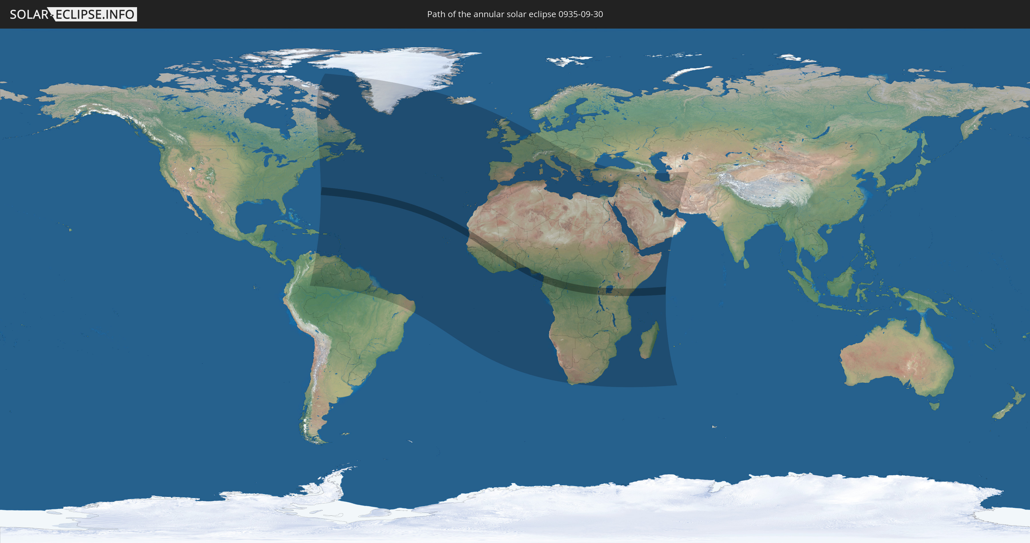
Annular solar eclipse of 09/30/0935
| Day of week: | Friday |
| Maximum duration of eclipse: | 07m57s |
| Maximum width of eclipse path: | 241 km |
| Saros cycle: | 107 |
| Coverage: | 93.8% |
| Magnitude: | 0.9375 |
| Gamma: | 0.2716 |
Wo kann man die Sonnenfinsternis vom 09/30/0935 sehen?
Die Sonnenfinsternis am 09/30/0935 kann man in 138 Ländern als partielle Sonnenfinsternis beobachten.
Der Finsternispfad verläuft durch 22 Länder. Nur in diesen Ländern ist sie als annular Sonnenfinsternis zu sehen.
In den folgenden Ländern ist die Sonnenfinsternis annular zu sehen
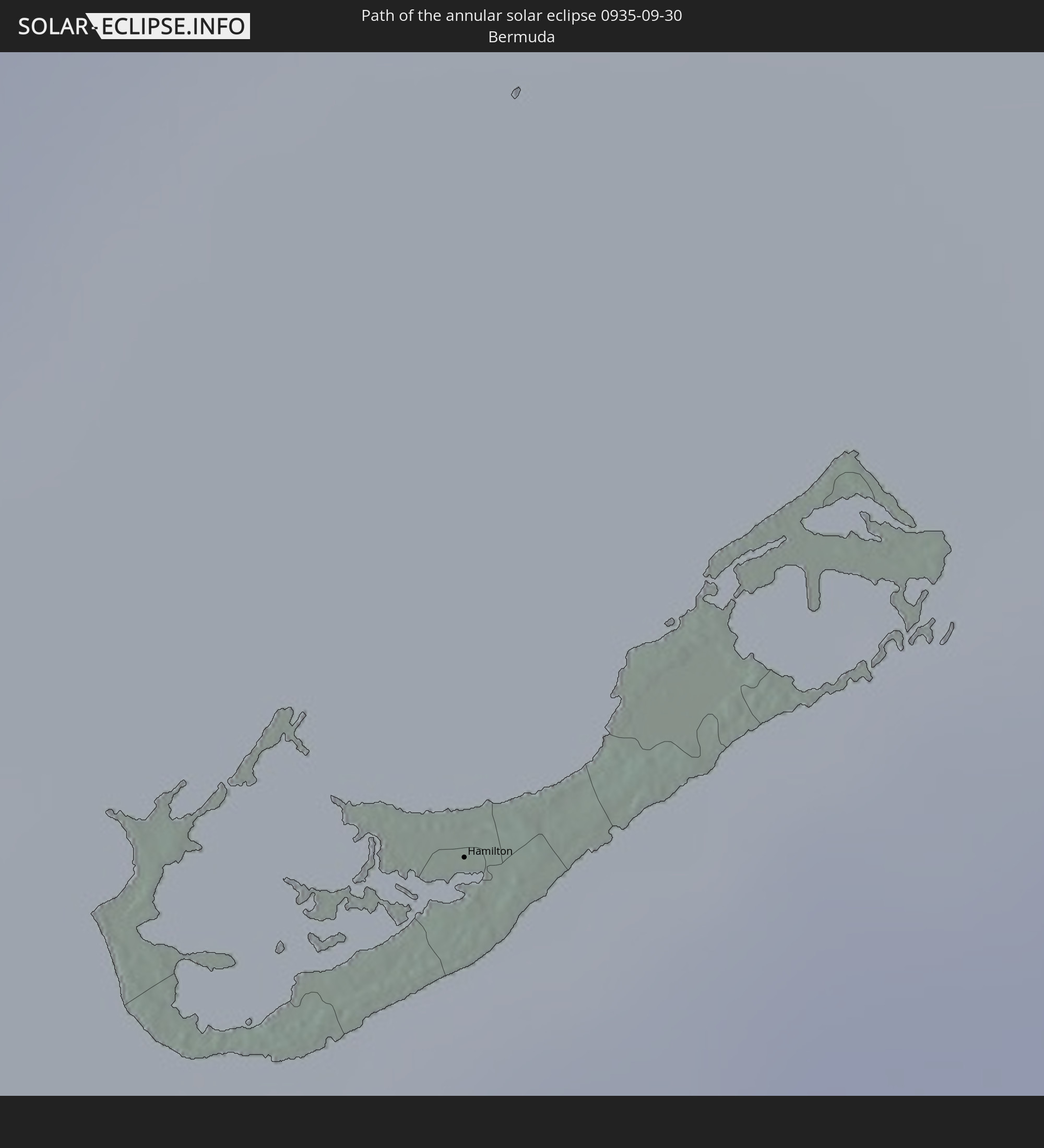 Bermuda
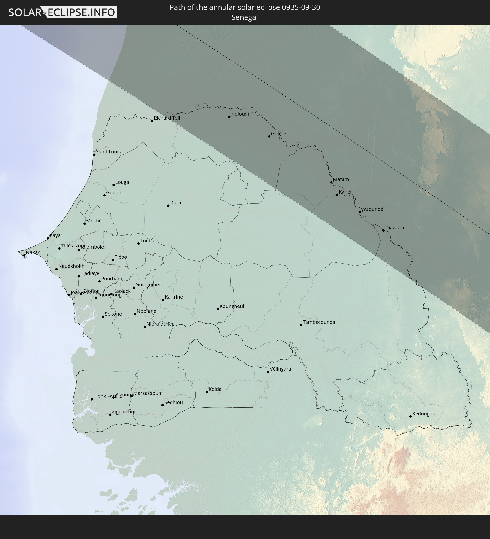 Senegal
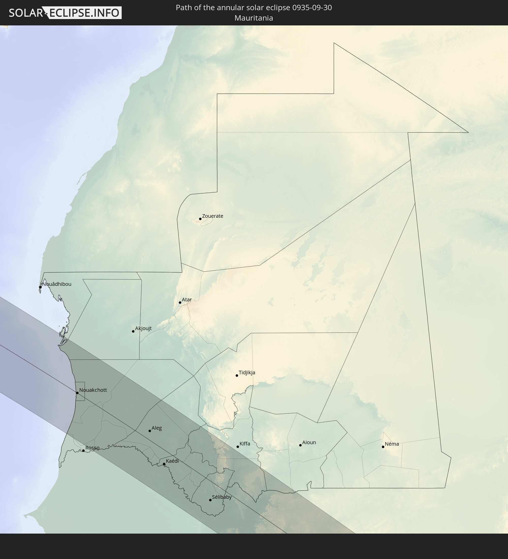 Mauritania
 Guinea
 Mali
Mali
 Ivory Coast
 Burkina Faso
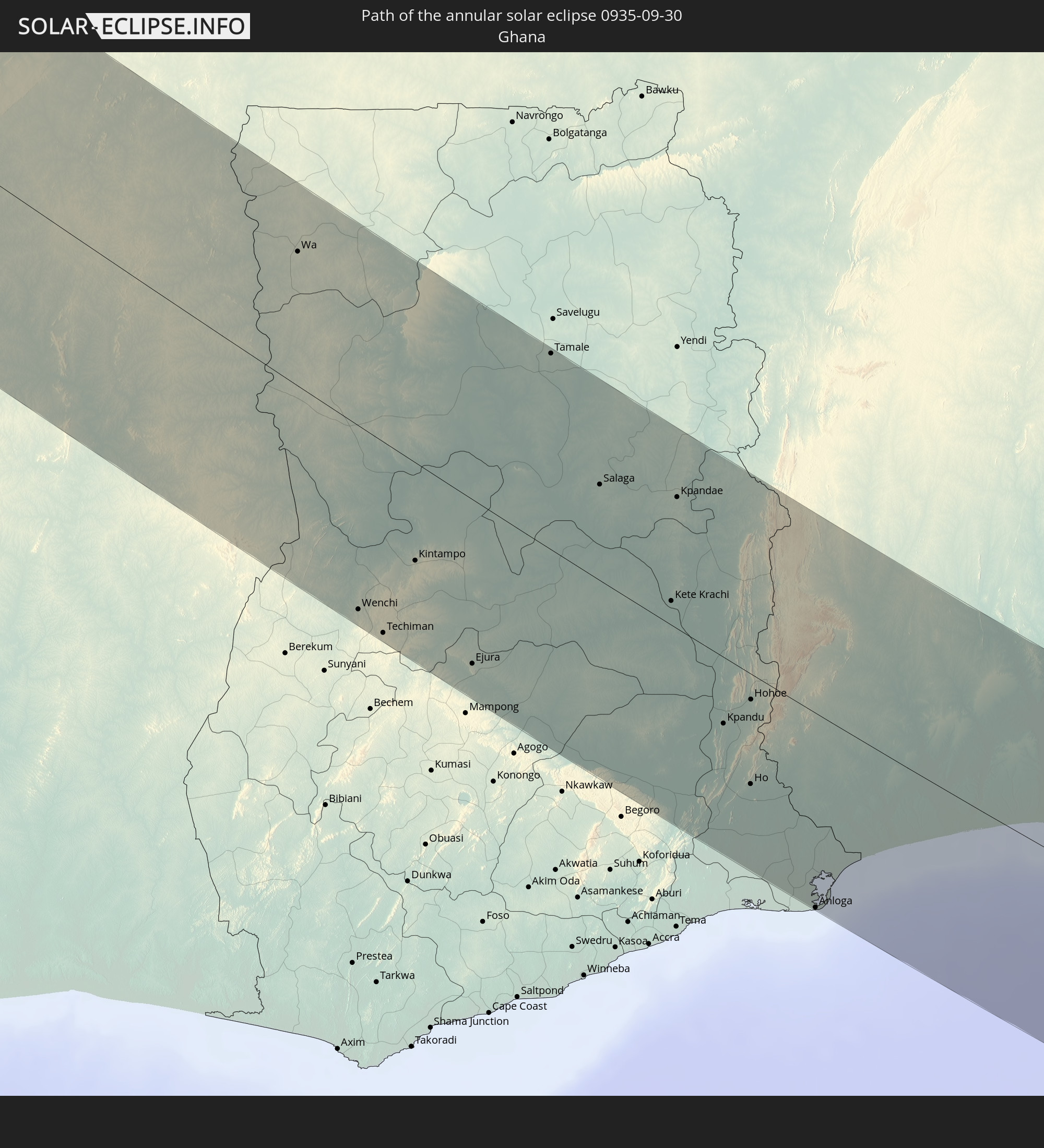 Ghana
Ghana
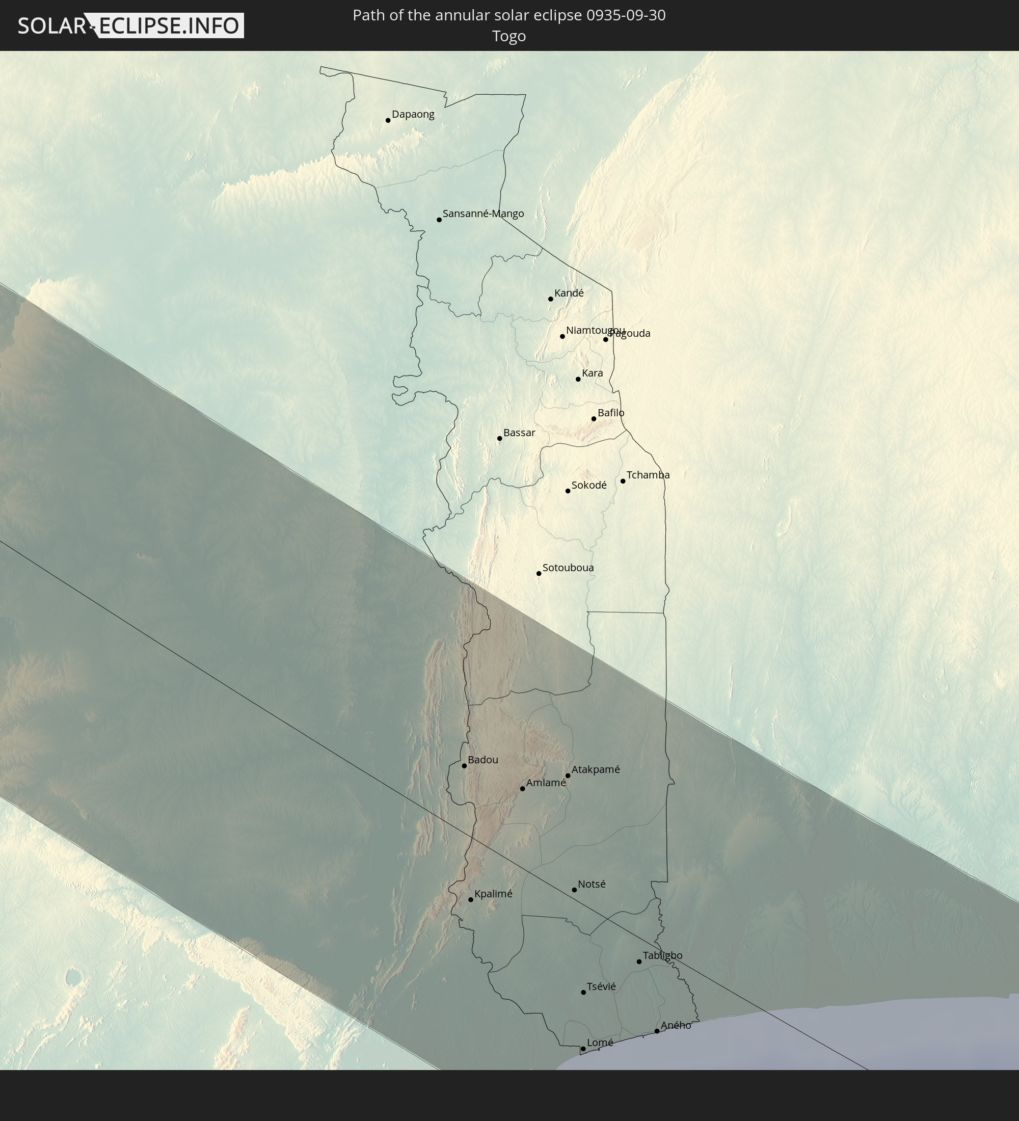 Togo
Togo
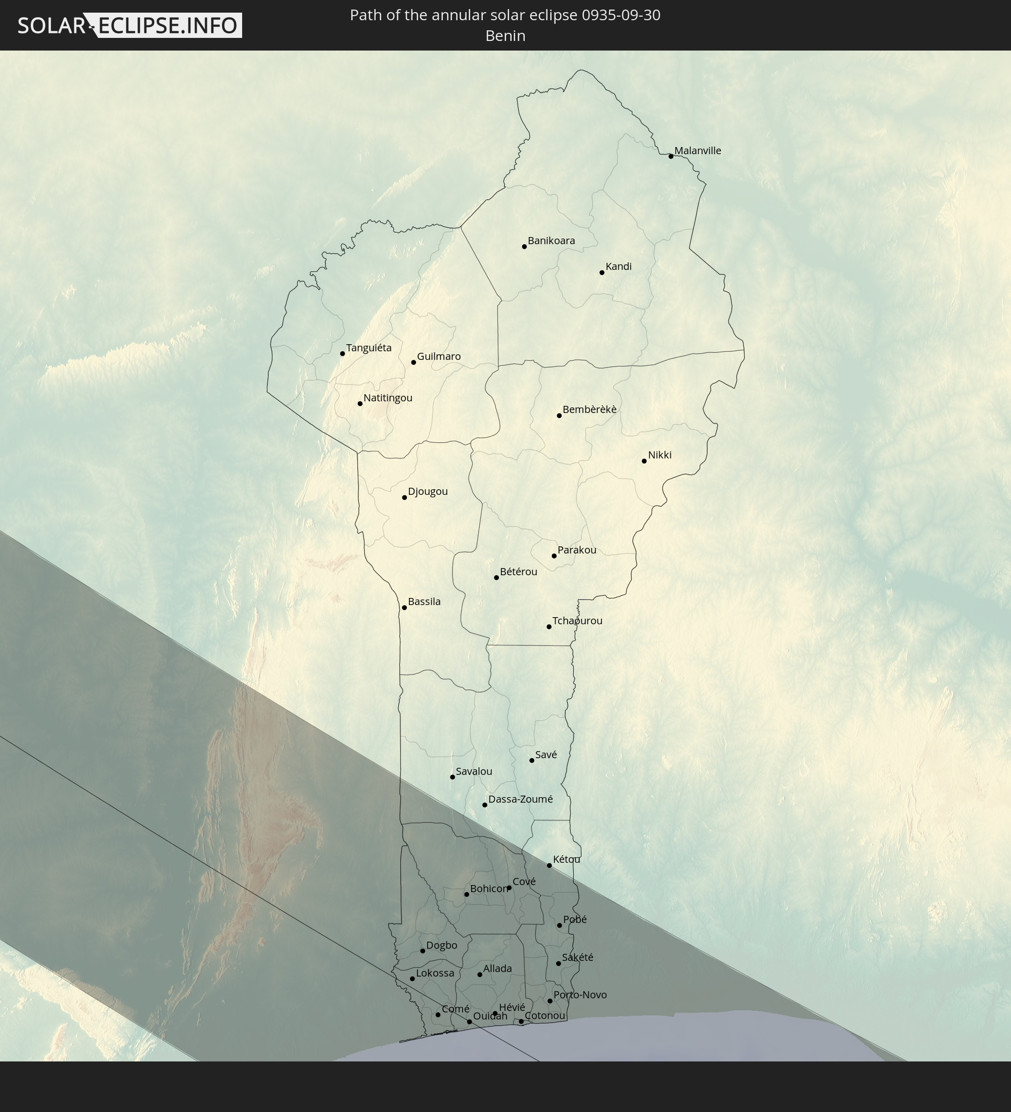 Benin
Benin
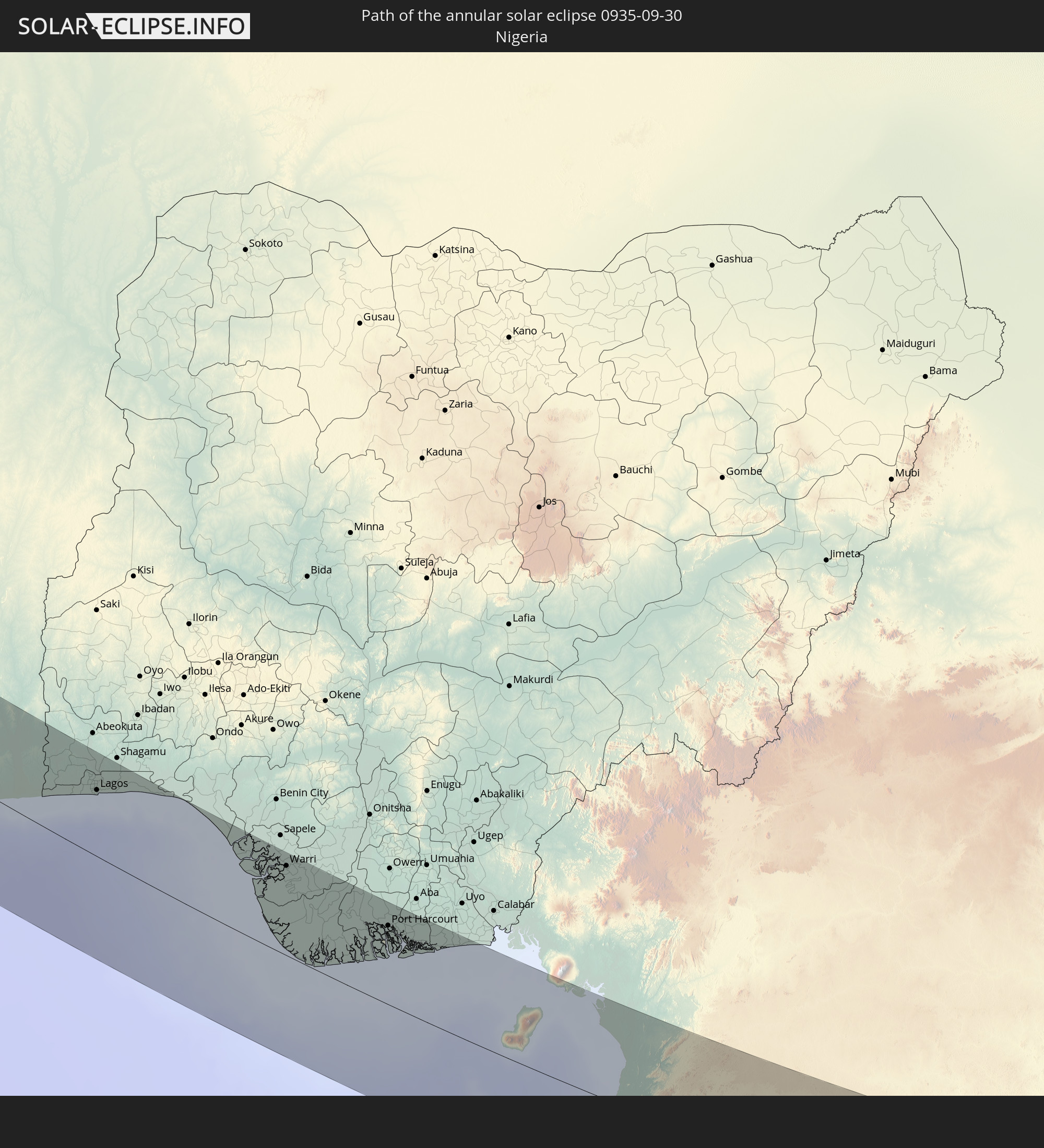 Nigeria
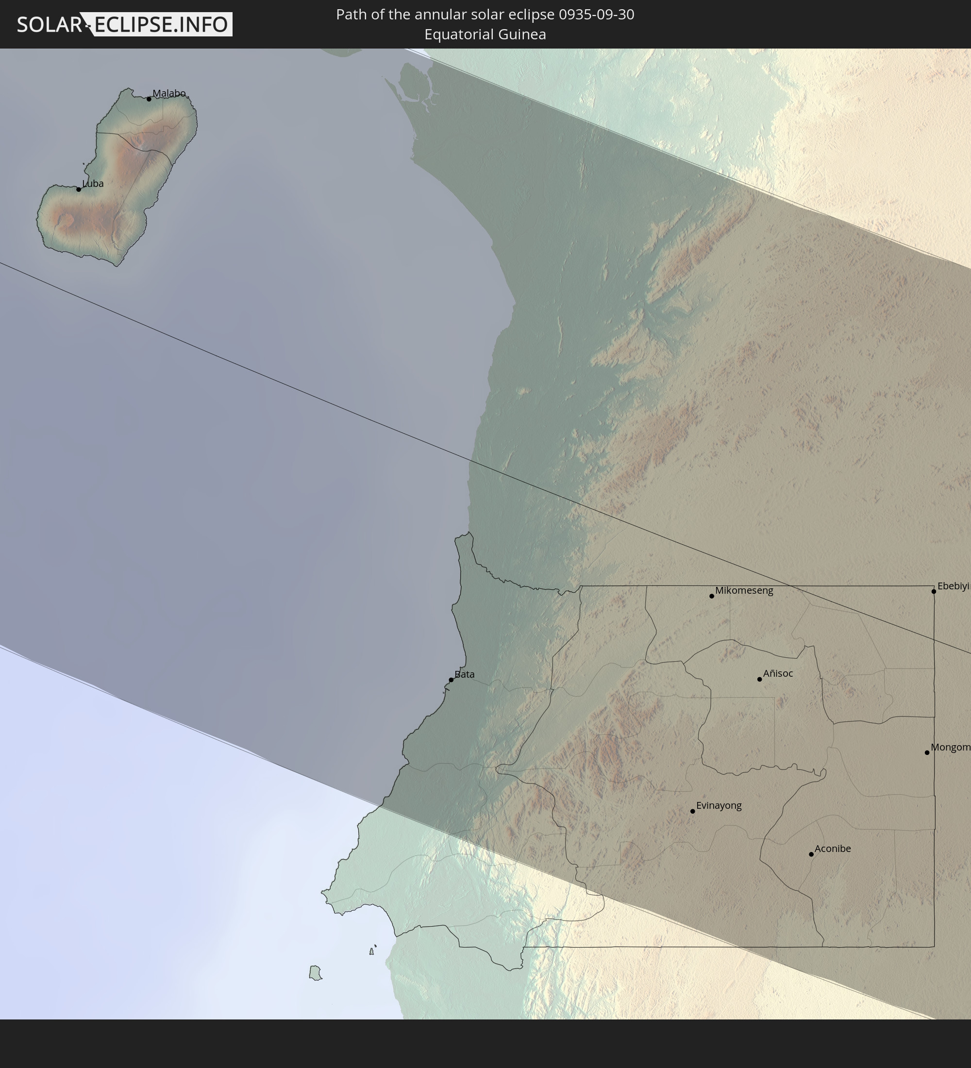 Equatorial Guinea
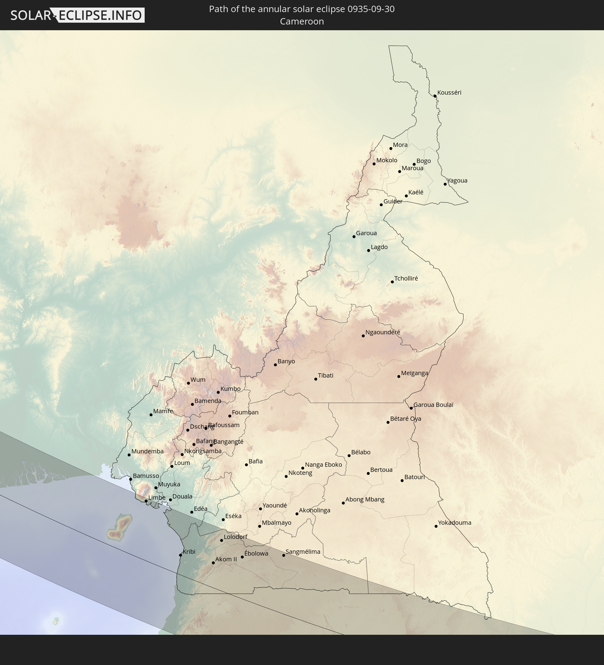 Cameroon
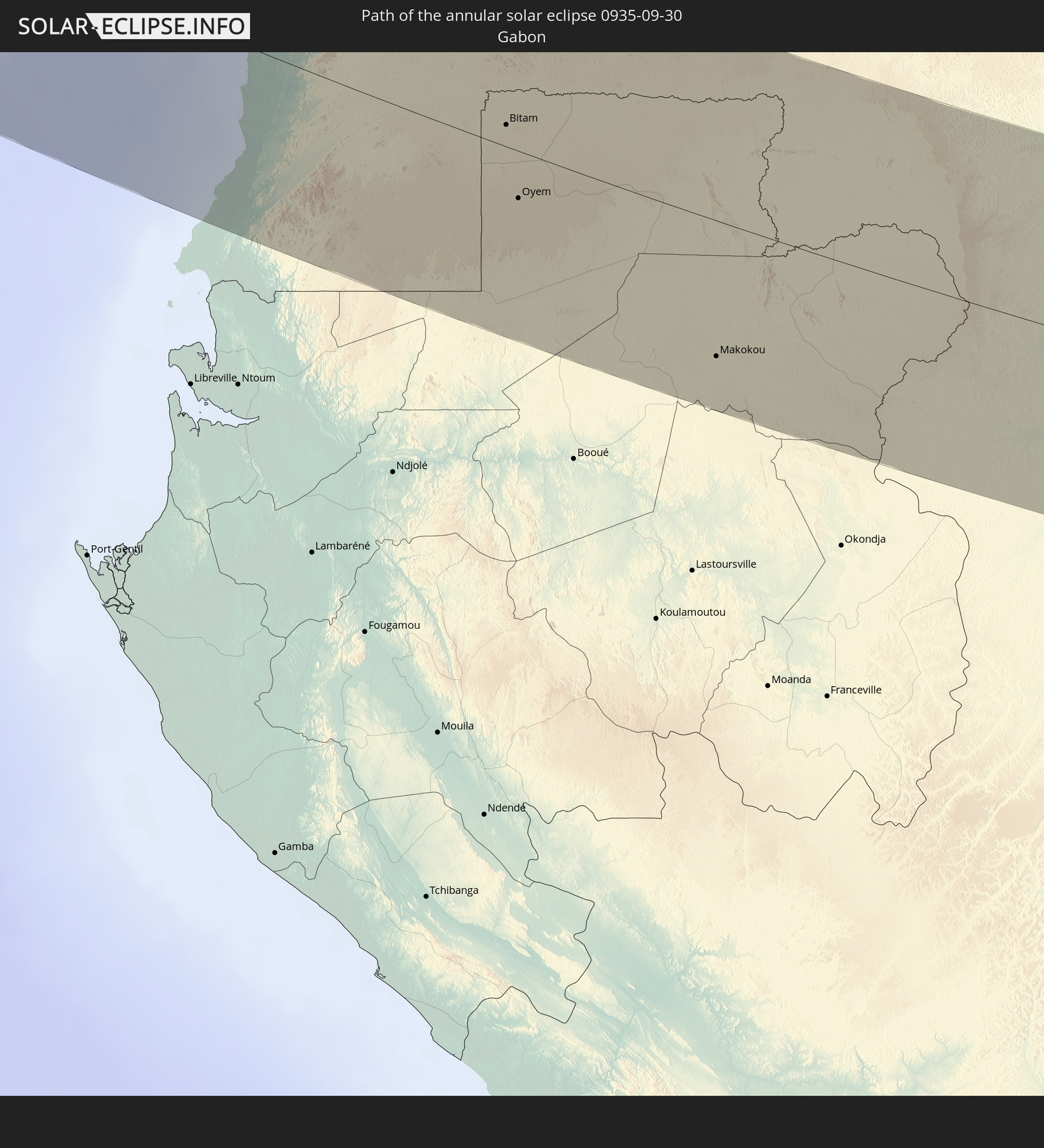 Gabon
Gabon
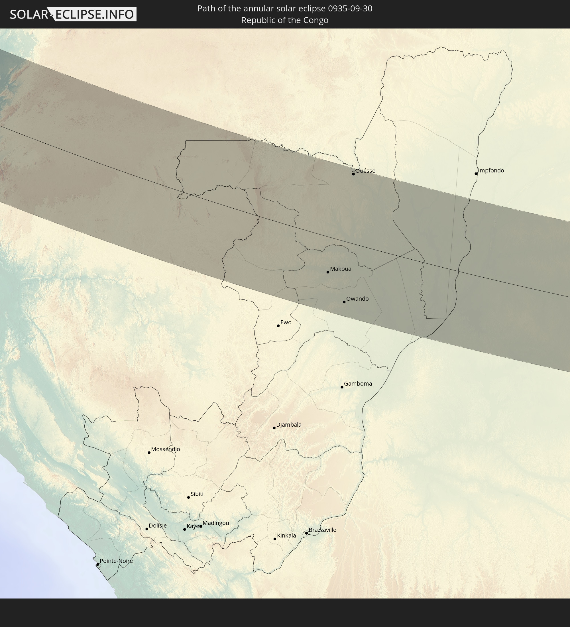 Republic of the Congo
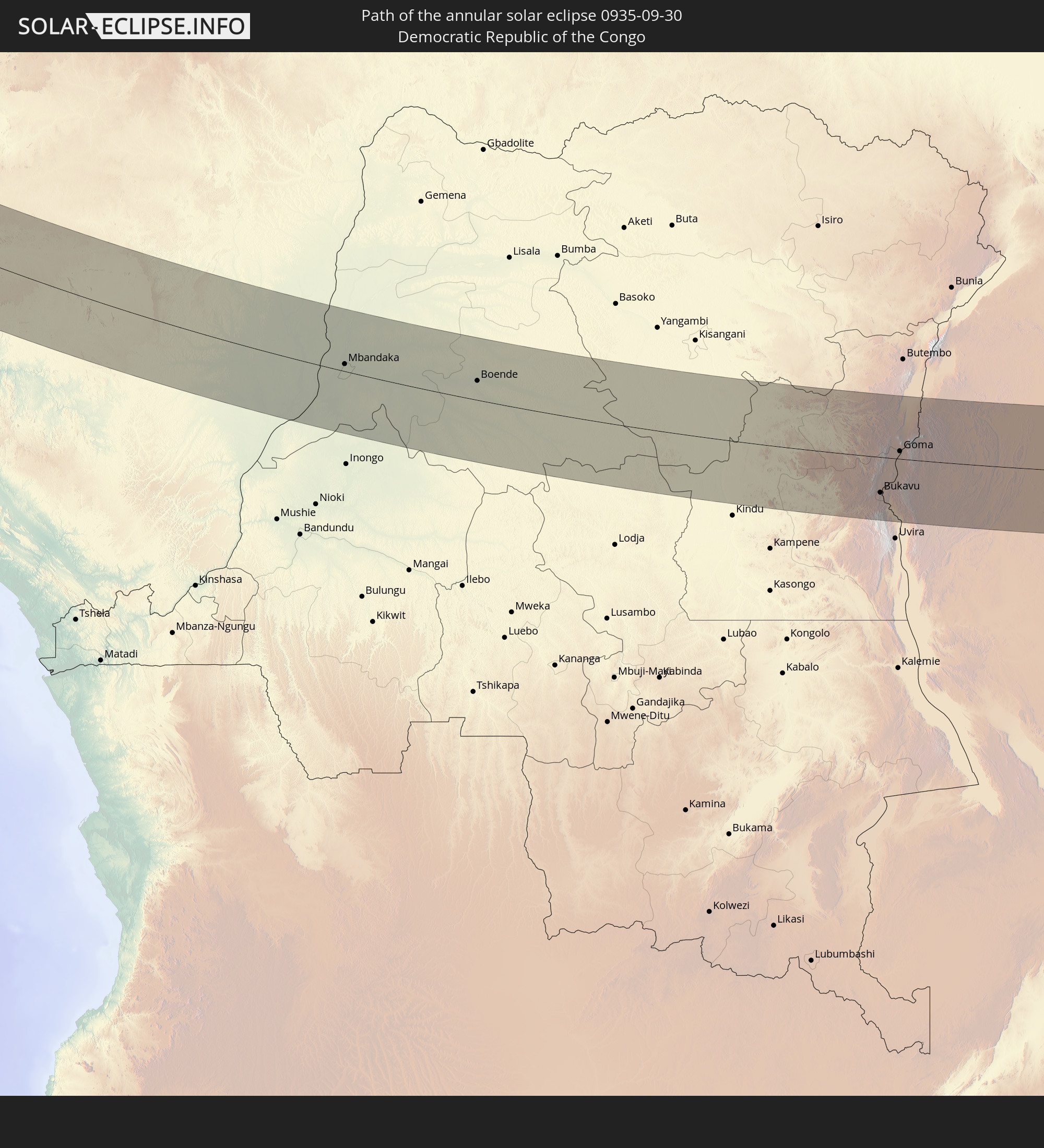 Democratic Republic of the Congo
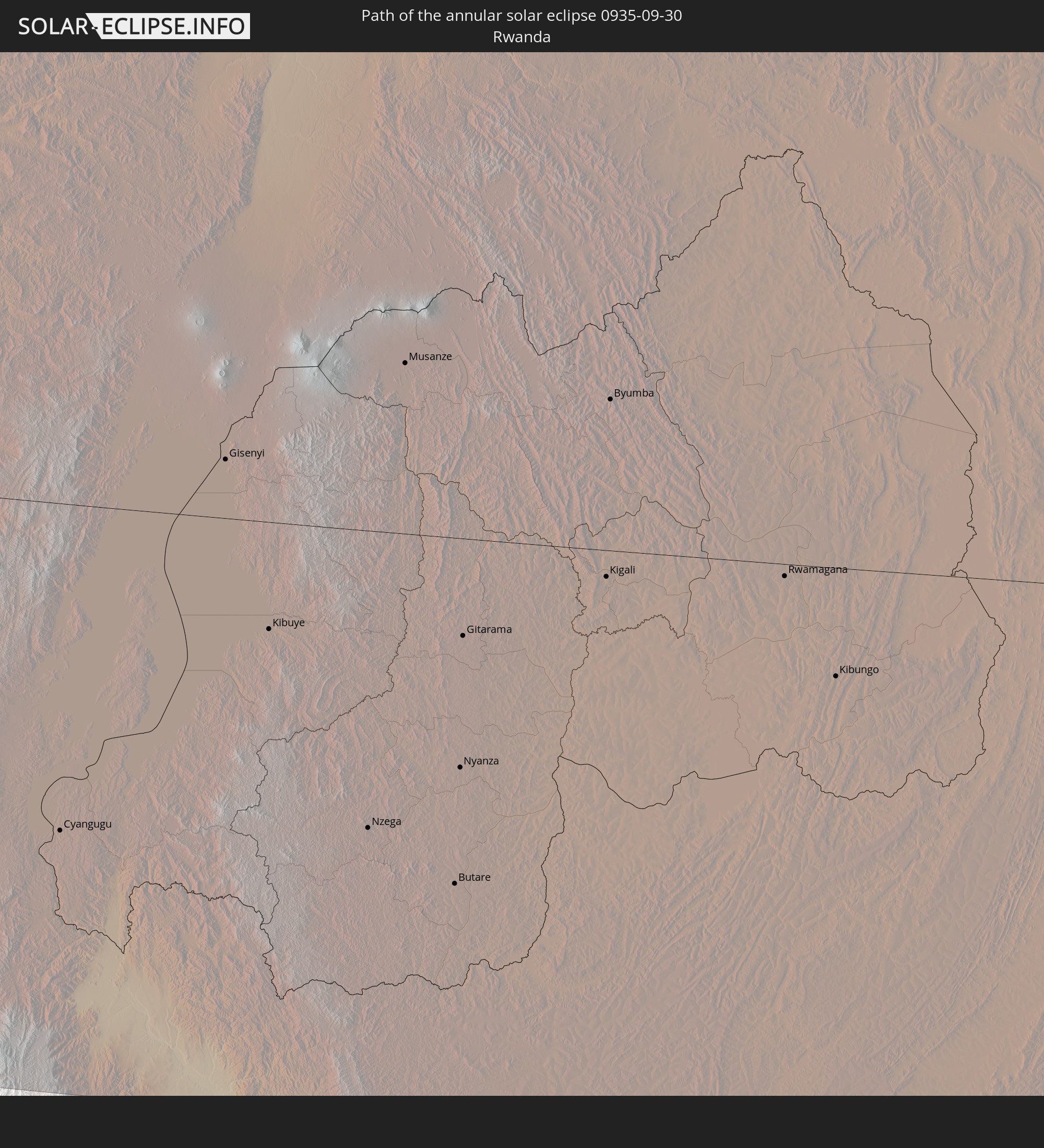 Rwanda
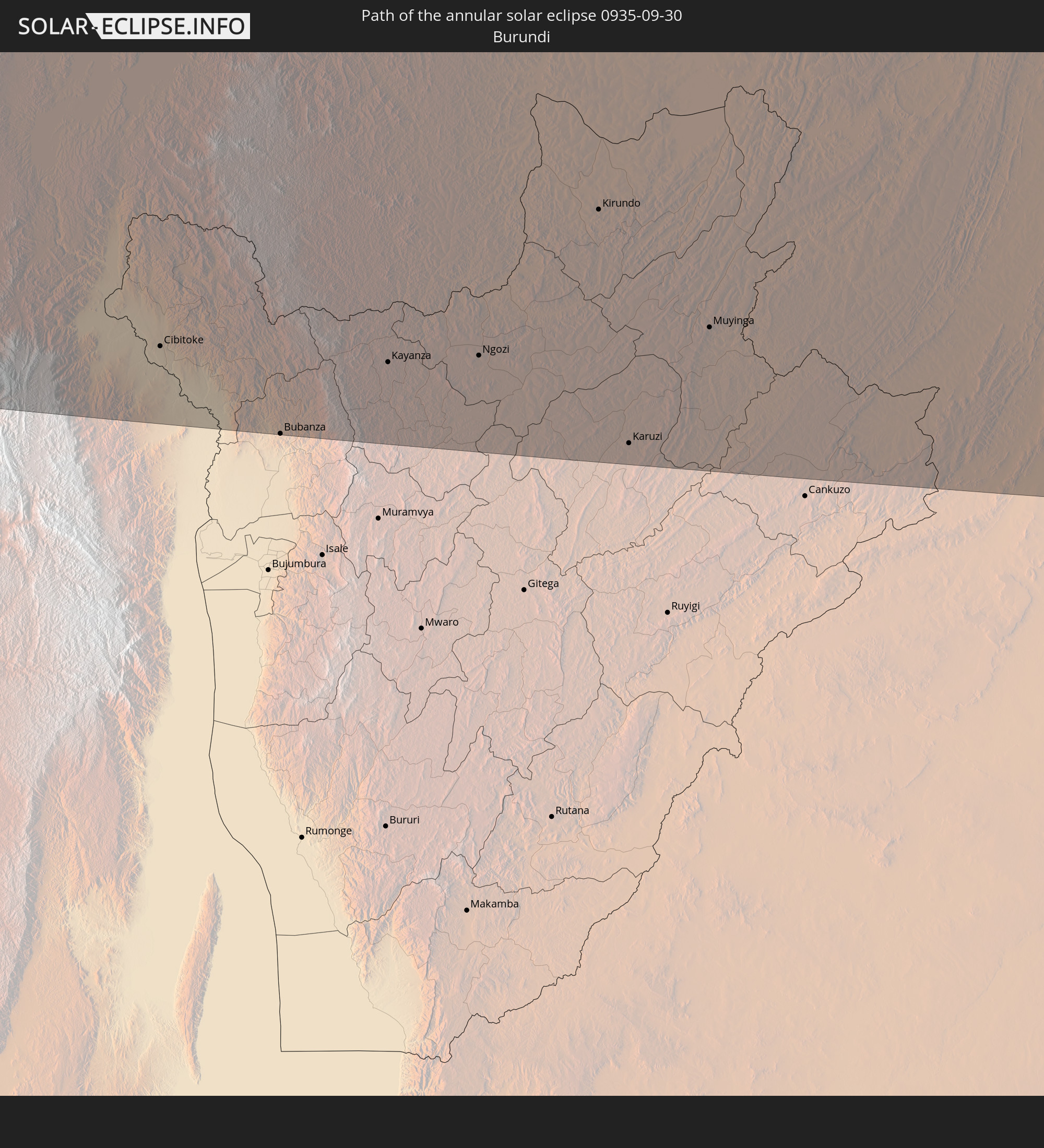 Burundi
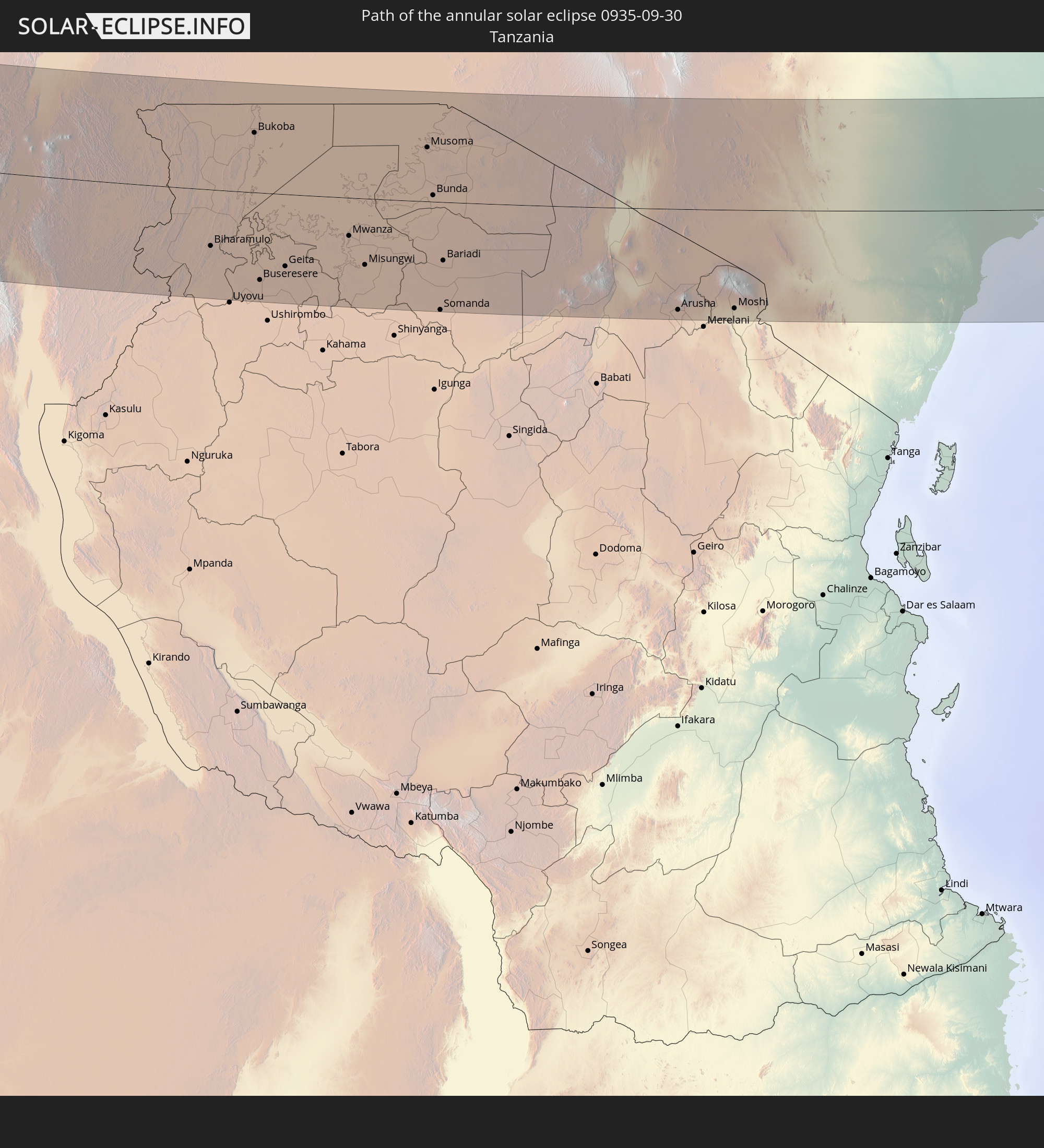 Tanzania
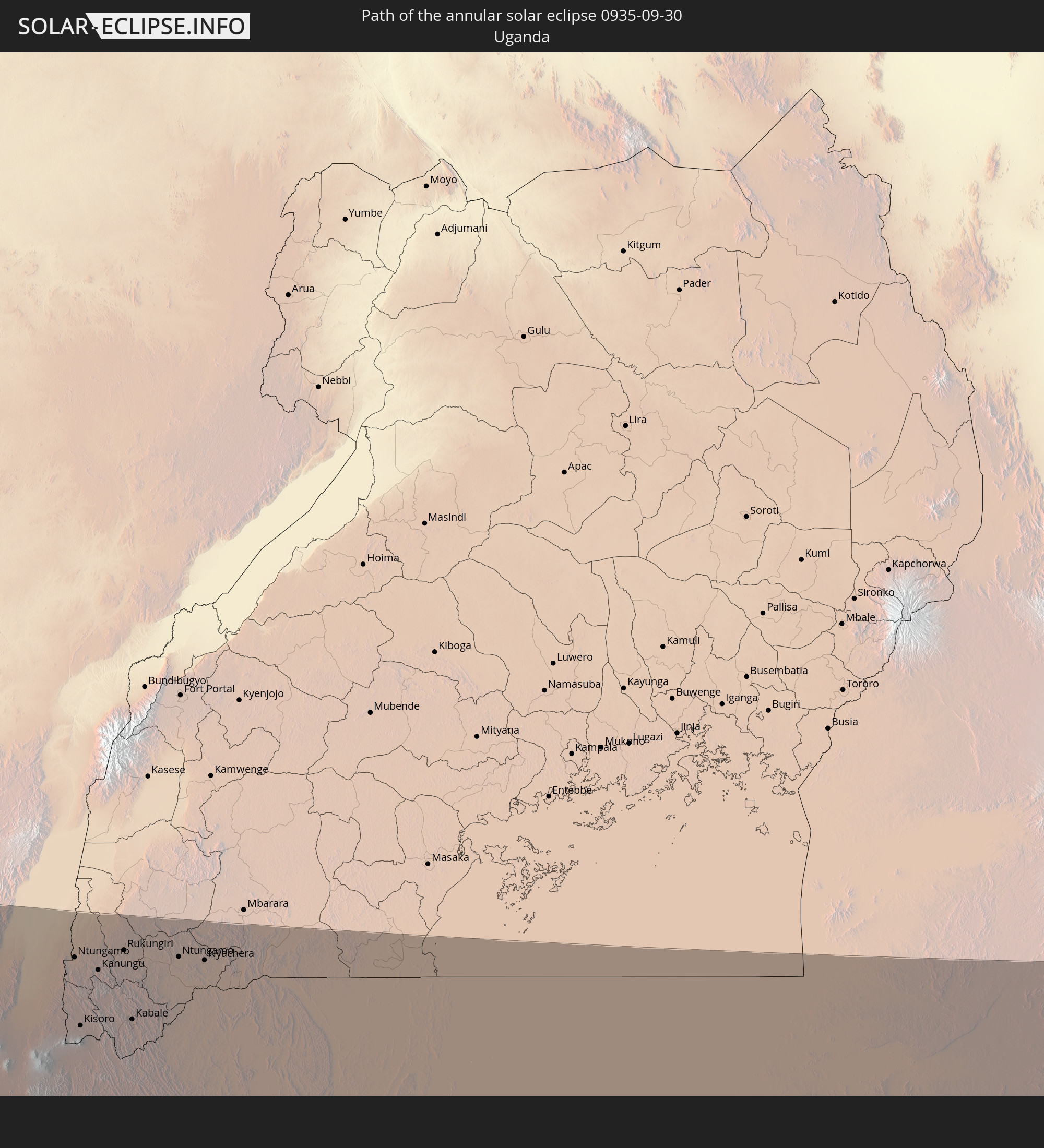 Uganda
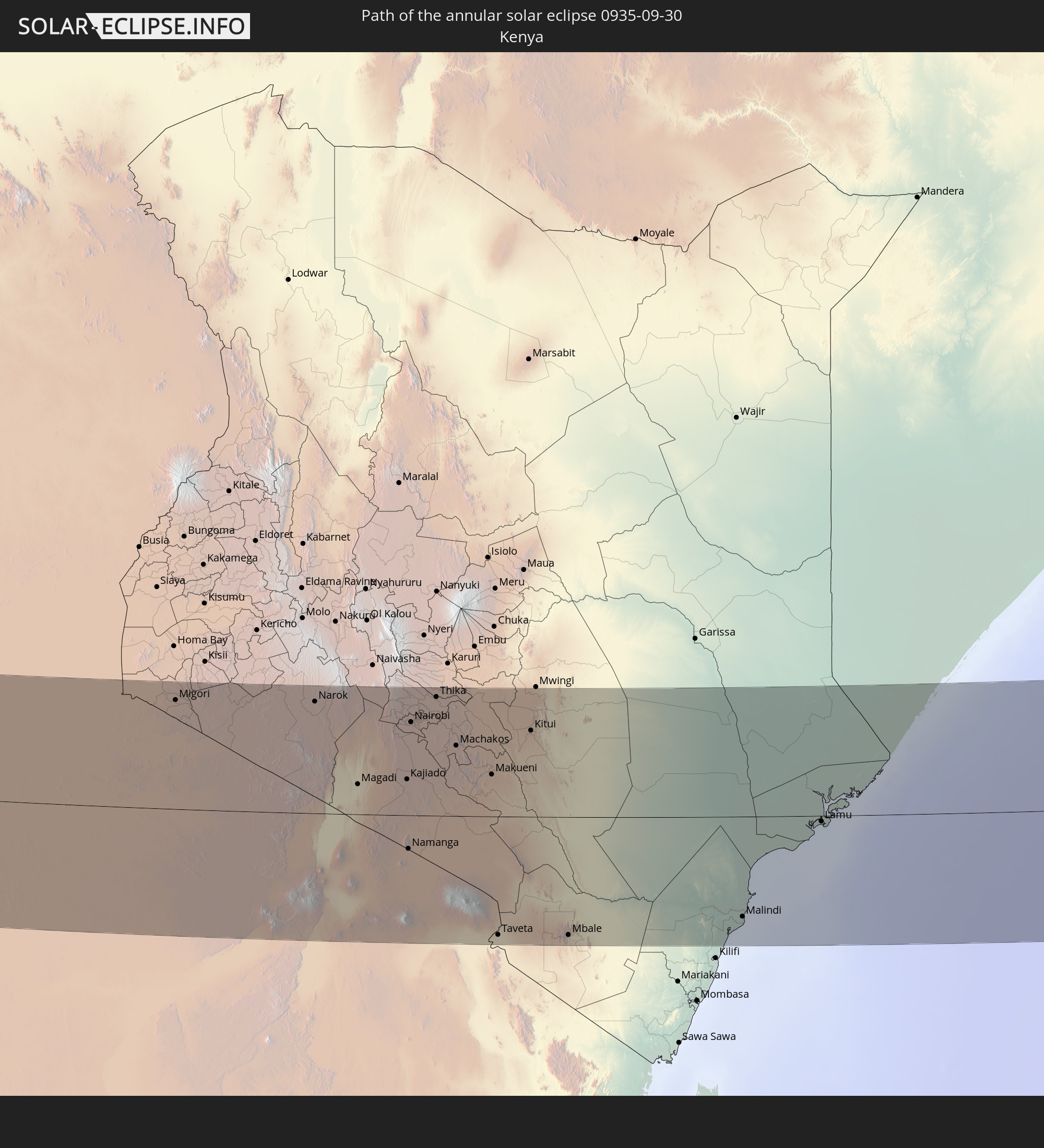 Kenya
Kenya
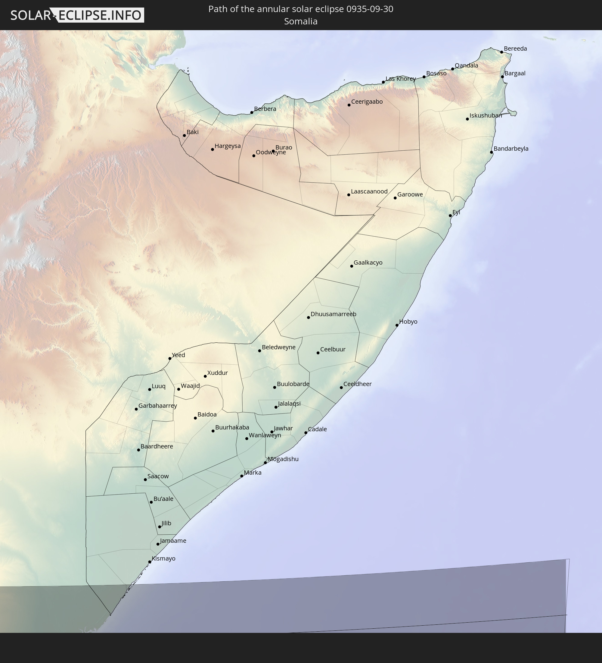 Somalia
In den folgenden Ländern ist die Sonnenfinsternis partiell zu sehen
 United States
 Canada
 Greenland
 Colombia
 Brazil
 Venezuela
 Dominican Republic
 Puerto Rico
 United States Virgin Islands
 Bermuda
 British Virgin Islands
 Anguilla
 Collectivity of Saint Martin
 Saint Barthélemy
 Saint Kitts and Nevis
 Antigua and Barbuda
 Montserrat
 Trinidad and Tobago
 Guadeloupe
 Grenada
 Dominica
 Saint Vincent and the Grenadines
 Guyana
 Martinique
 Saint Lucia
 Barbados
 Suriname
 Saint Pierre and Miquelon
 French Guiana
 Portugal
 Cabo Verde
 Iceland
 Spain
Spain
 Senegal
 Mauritania
 The Gambia
 Guinea-Bissau
 Guinea
 Saint Helena, Ascension and Tristan da Cunha
 Sierra Leone
 Morocco
 Mali
Mali
 Liberia
 Republic of Ireland
 Algeria
 United Kingdom
 Ivory Coast
 Burkina Faso
 Gibraltar
 France
 Isle of Man
 Ghana
Ghana
 Guernsey
 Jersey
 Togo
Togo
 Niger
Niger
 Benin
Benin
 Andorra
 Belgium
 Nigeria
 Netherlands
 Equatorial Guinea
 Luxembourg
 Germany
 Switzerland
 São Tomé and Príncipe
 Italy
Italy
 Monaco
 Tunisia
 Cameroon
 Gabon
Gabon
 Libya
Libya
 Liechtenstein
 Austria
 Republic of the Congo
 Angola
 Namibia
 Czechia
 Democratic Republic of the Congo
 San Marino
 Vatican City
 Slovenia
 Chad
Chad
 Croatia
 Malta
Malta
 Central African Republic
 Bosnia and Herzegovina
 Hungary
 South Africa
 Montenegro
 Serbia
 Albania
 Greece
 Botswana
 Romania
 Republic of Macedonia
 Sudan
Sudan
 Zambia
 Bulgaria
 Egypt
Egypt
 Zimbabwe
 Turkey
 Lesotho
 Rwanda
 Burundi
 Tanzania
 Uganda
 Mozambique
 Swaziland
 Cyprus
 Malawi
 Ethiopia
 Kenya
Kenya
 State of Palestine
 Israel
 Saudi Arabia
 Jordan
 Lebanon
 Syria
Syria
 Eritrea
 Iraq
Iraq
 French Southern and Antarctic Lands
 Somalia
 Djibouti
 Yemen
Yemen
 Madagascar
 Comoros
 Armenia
 Iran
Iran
 Azerbaijan
 Mayotte
 Seychelles
 Kuwait
 Bahrain
 Qatar
Qatar
 United Arab Emirates
 Oman
Oman
 Turkmenistan
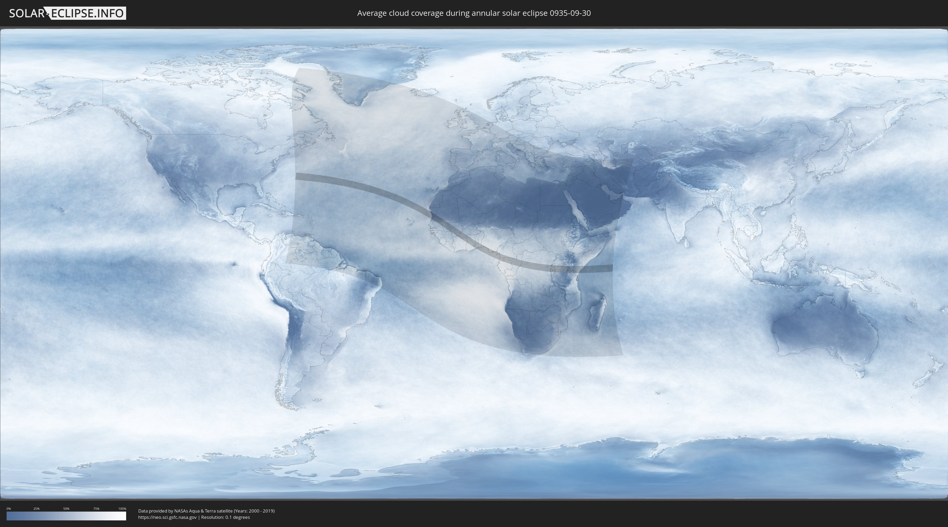
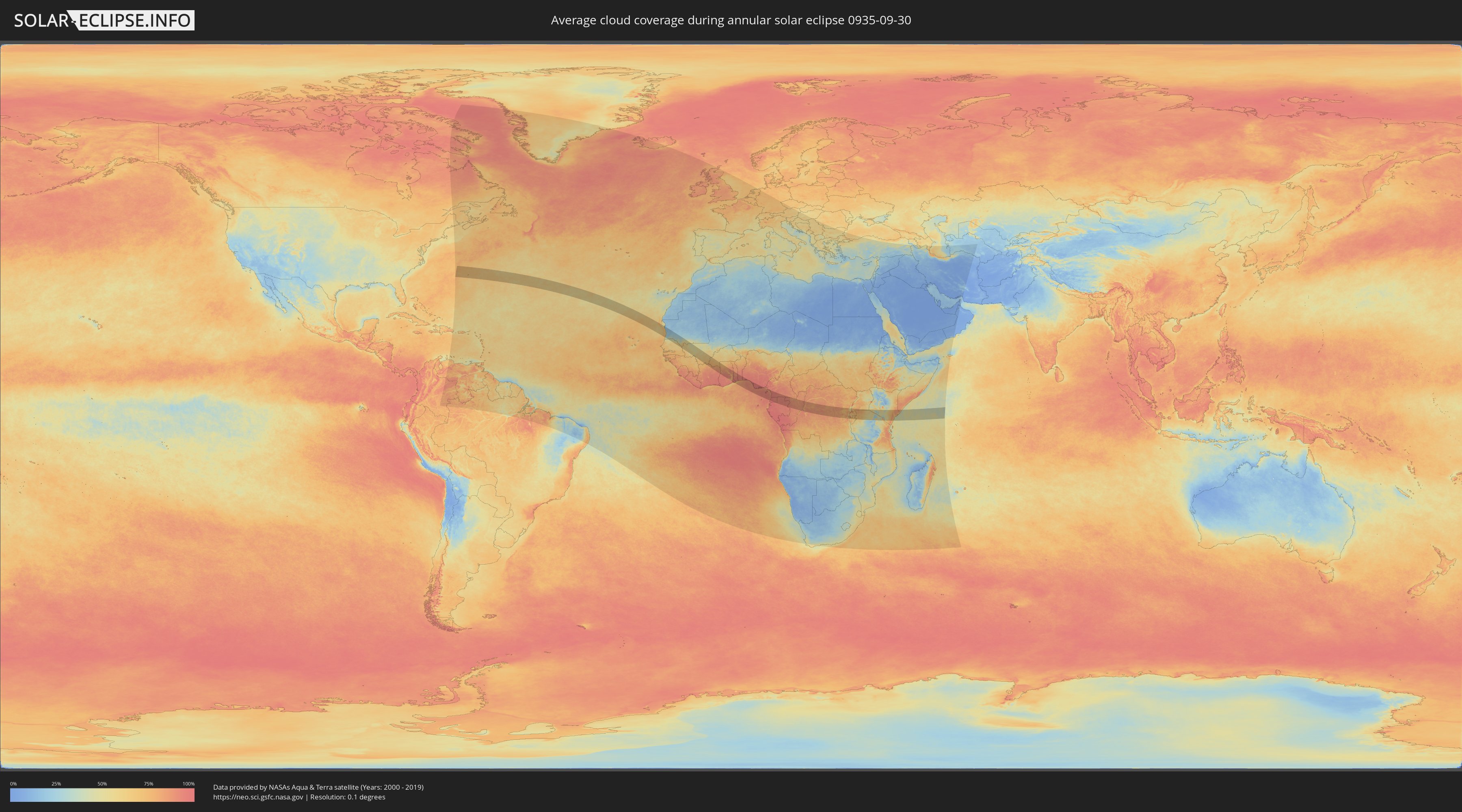
How will be the weather during the annular solar eclipse on 09/30/0935?
Where is the best place to see the annular solar eclipse of 09/30/0935?
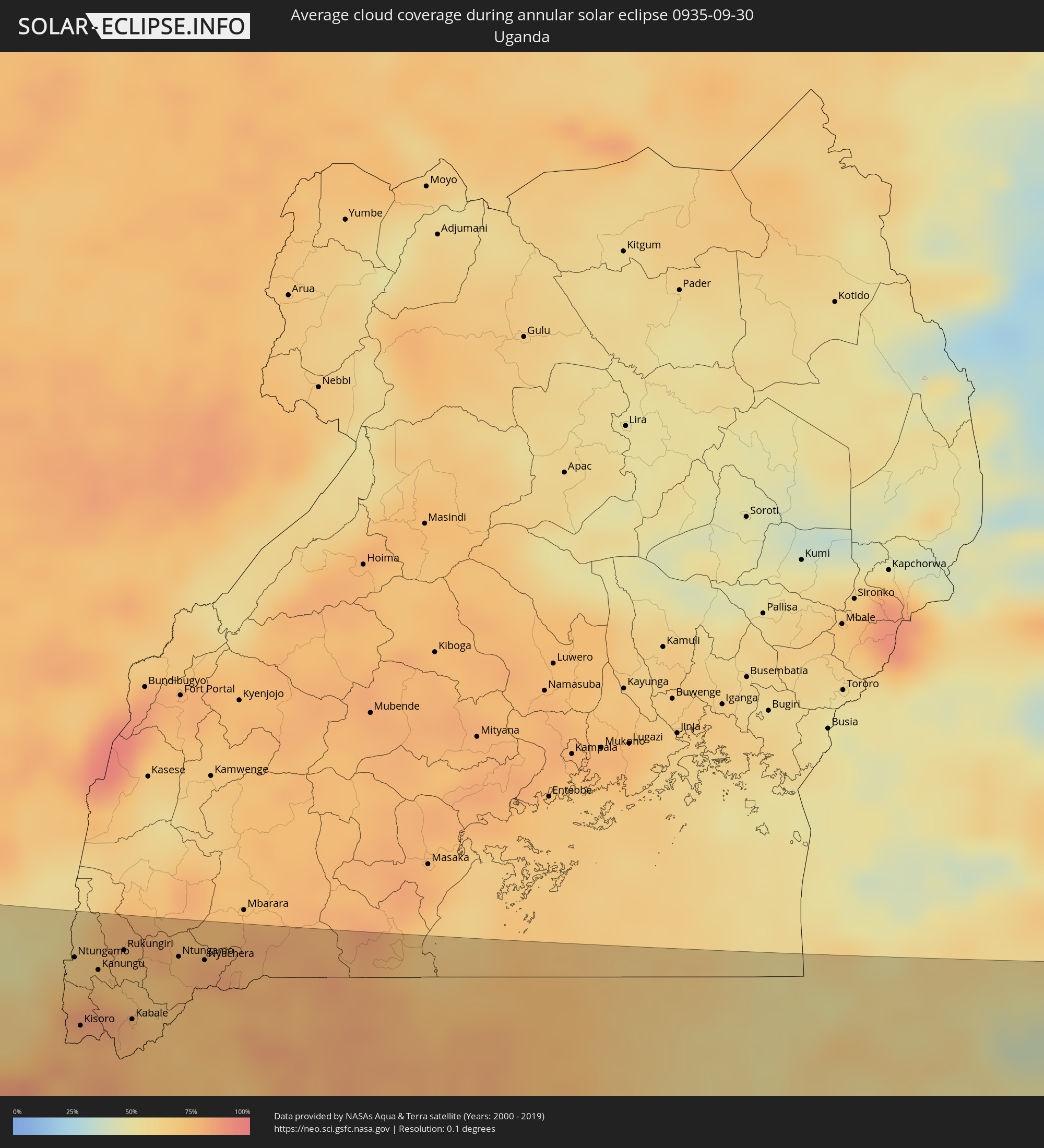
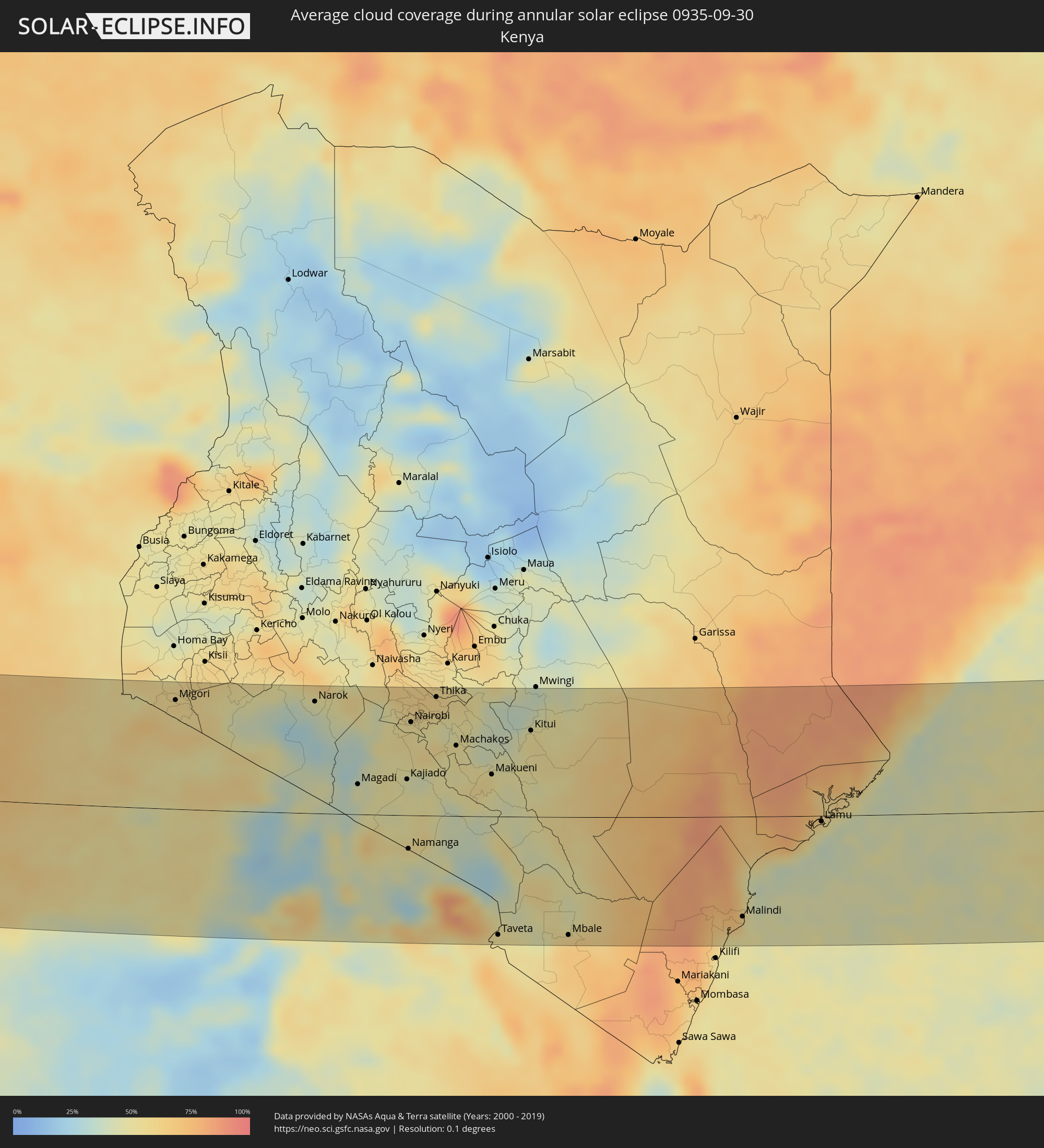
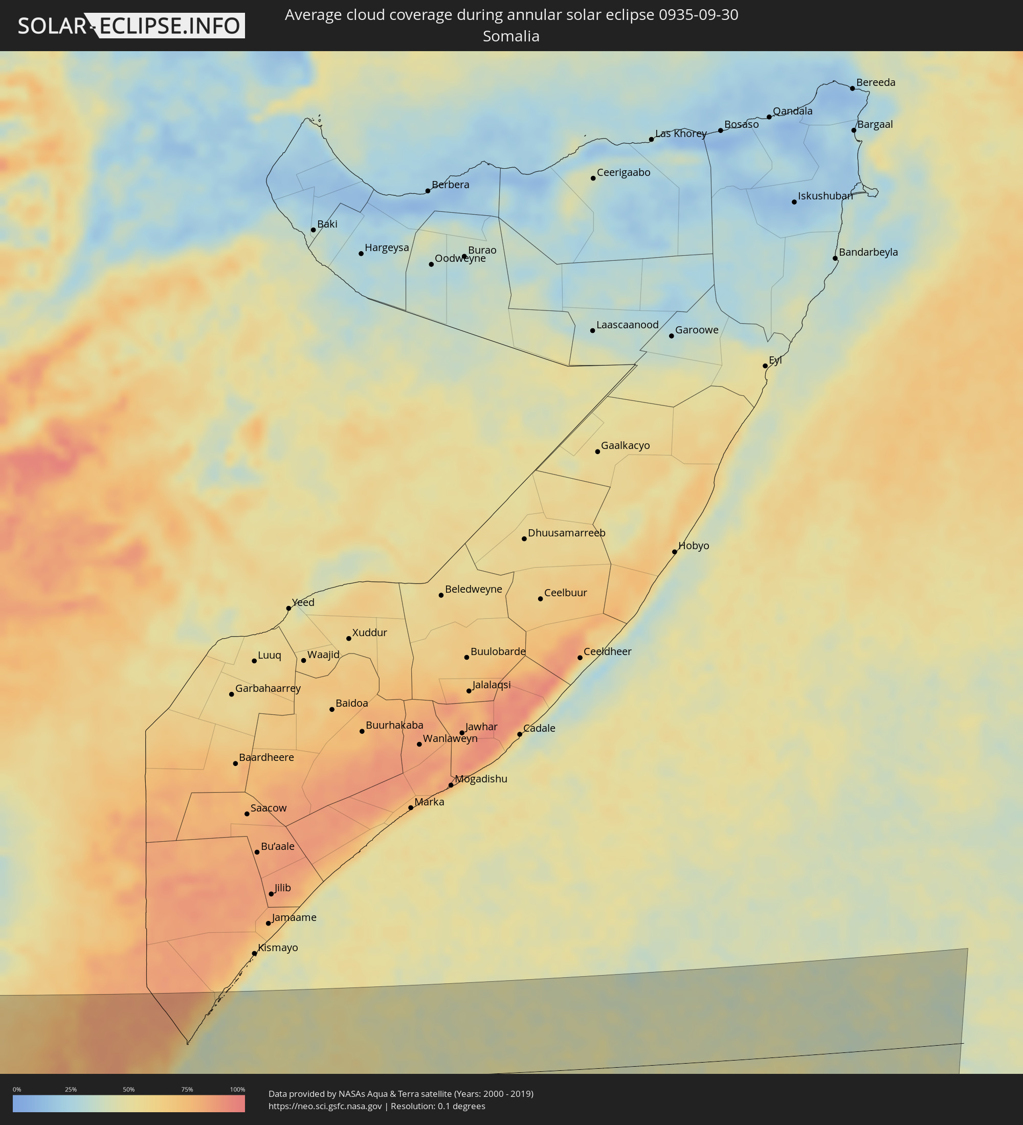
The following maps show the average cloud coverage for the day of the annular solar eclipse.
With the help of these maps, it is possible to find the place along the eclipse path, which has the best
chance of a cloudless sky.
Nevertheless, you should consider local circumstances and inform about the weather of your chosen
observation site.
The data is provided by NASAs satellites
AQUA and TERRA.
The cloud maps are averaged over a period of 19 years (2000 - 2019).
Detailed country maps
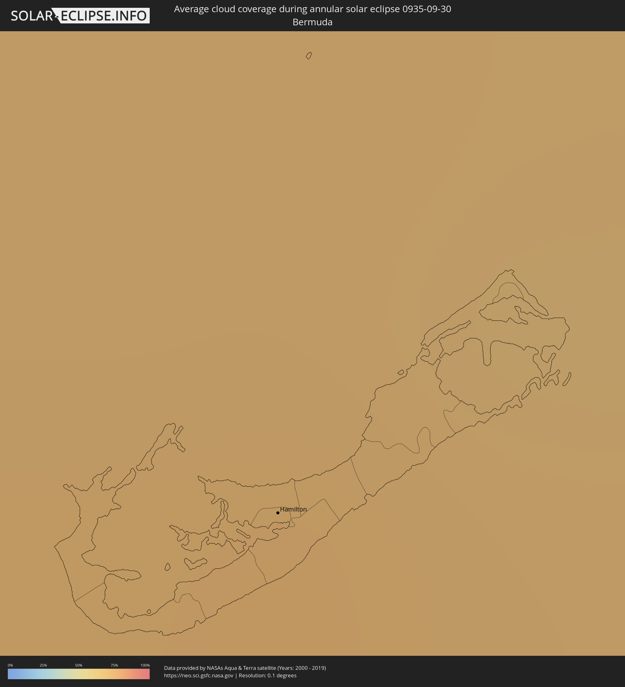 Bermuda
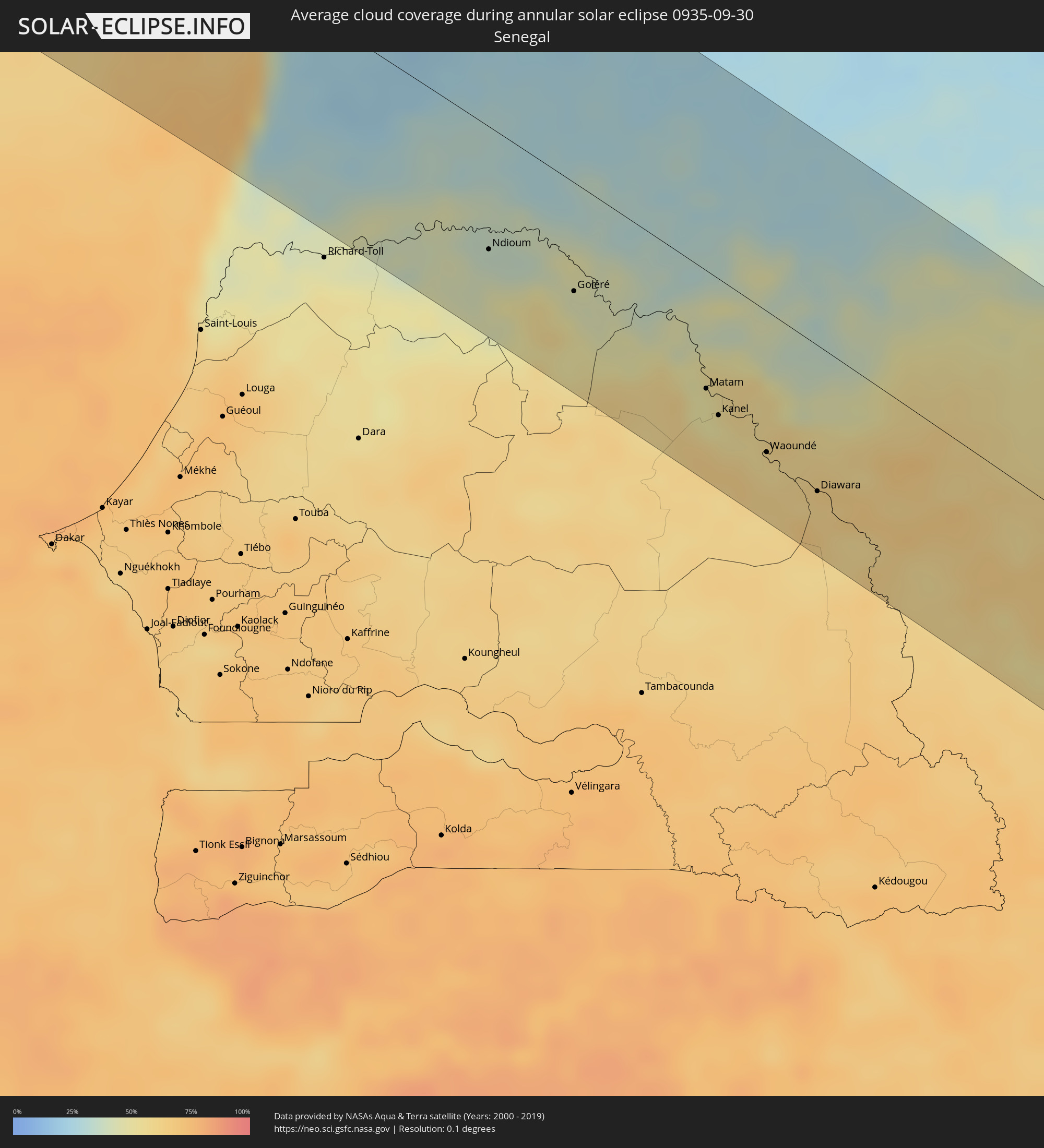 Senegal
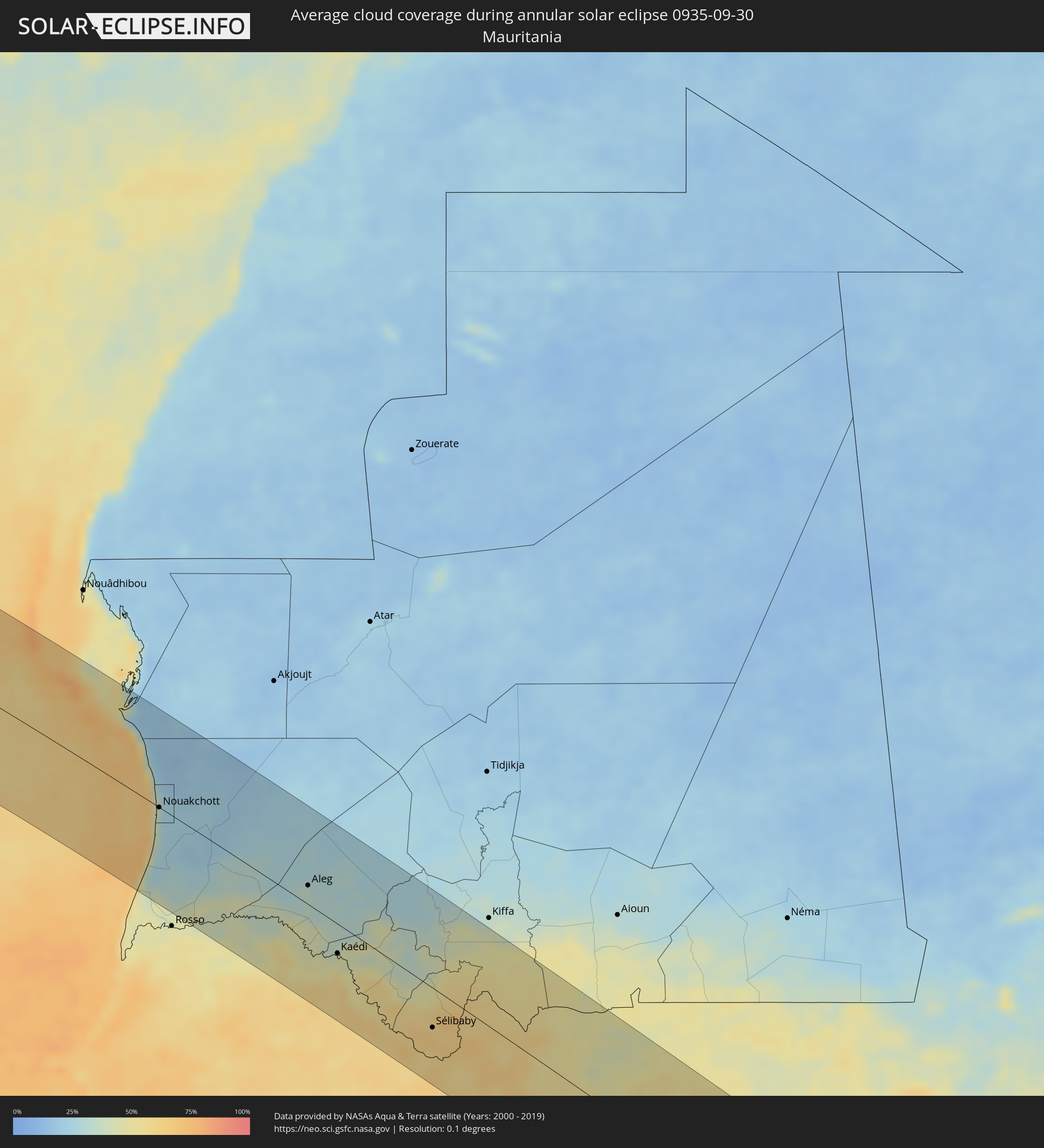 Mauritania
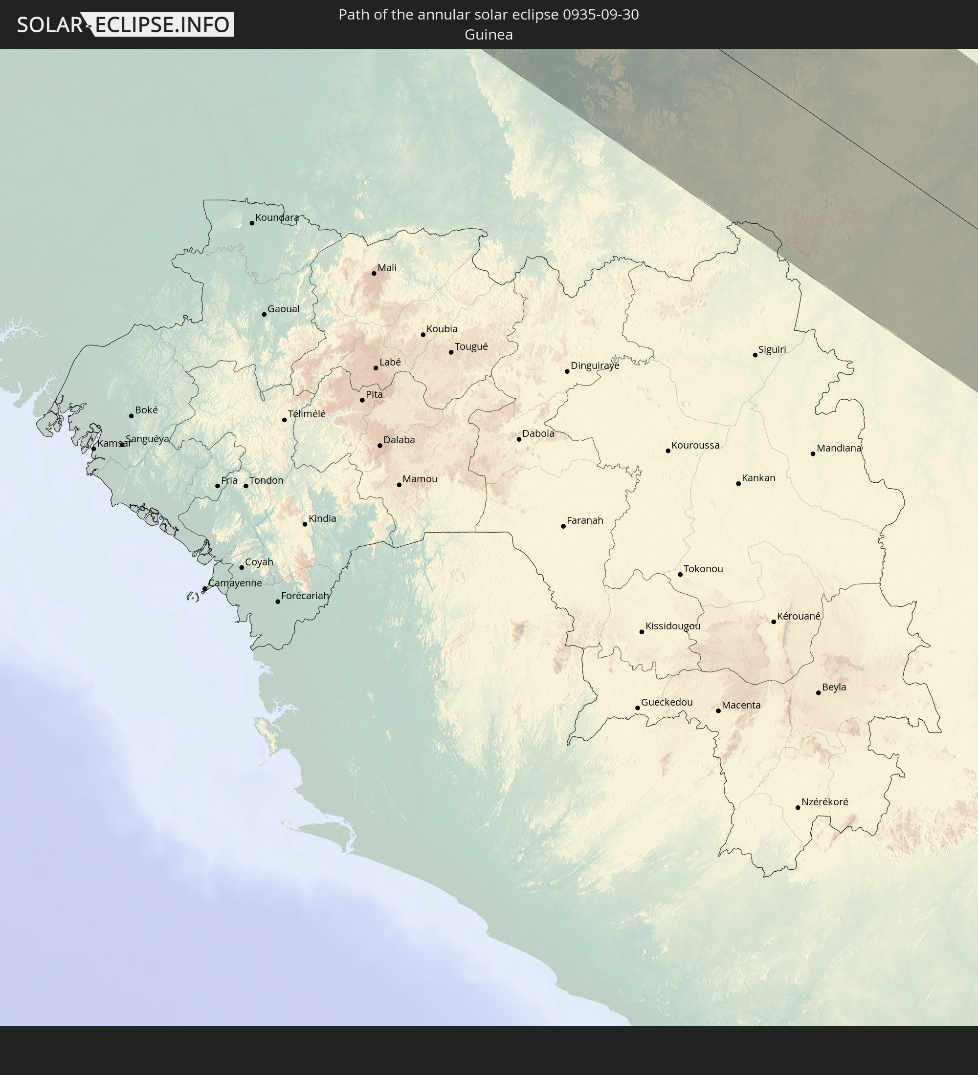
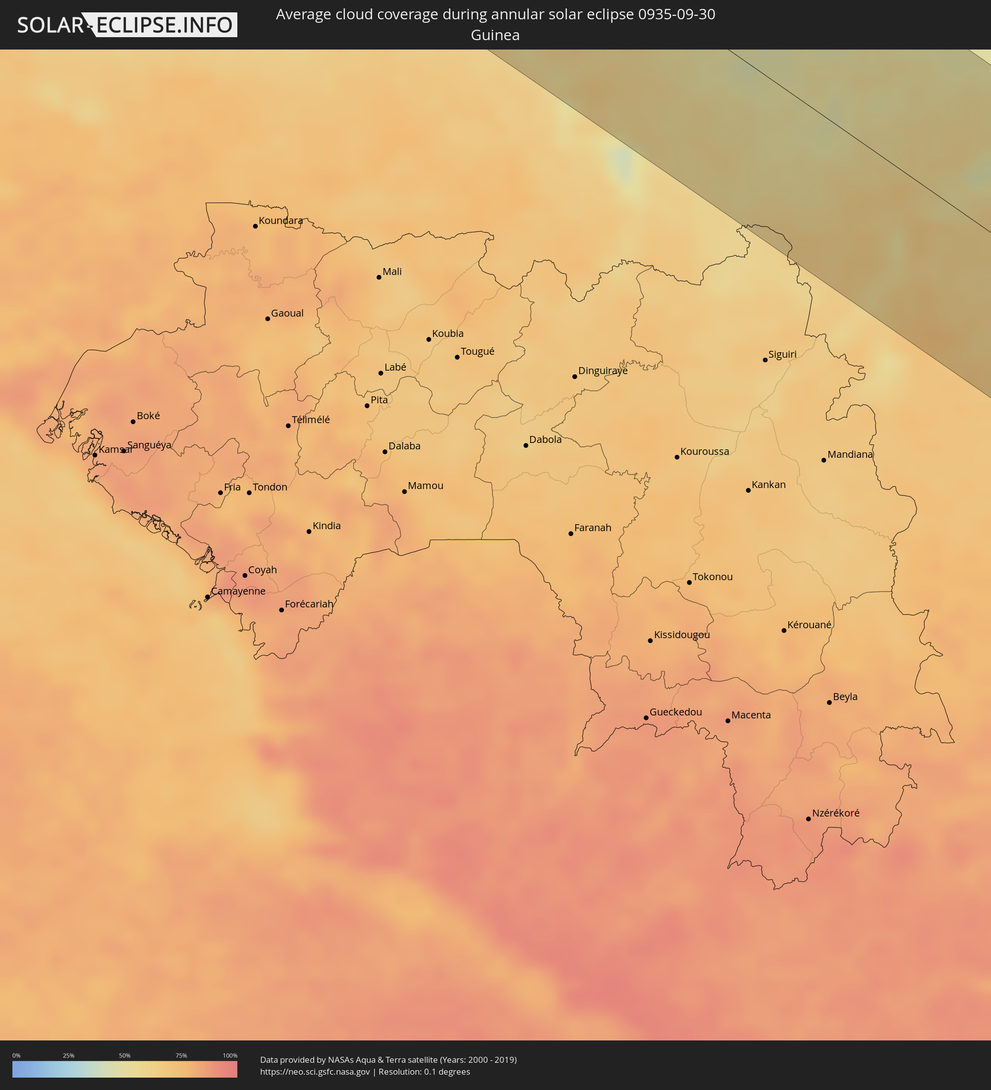 Guinea
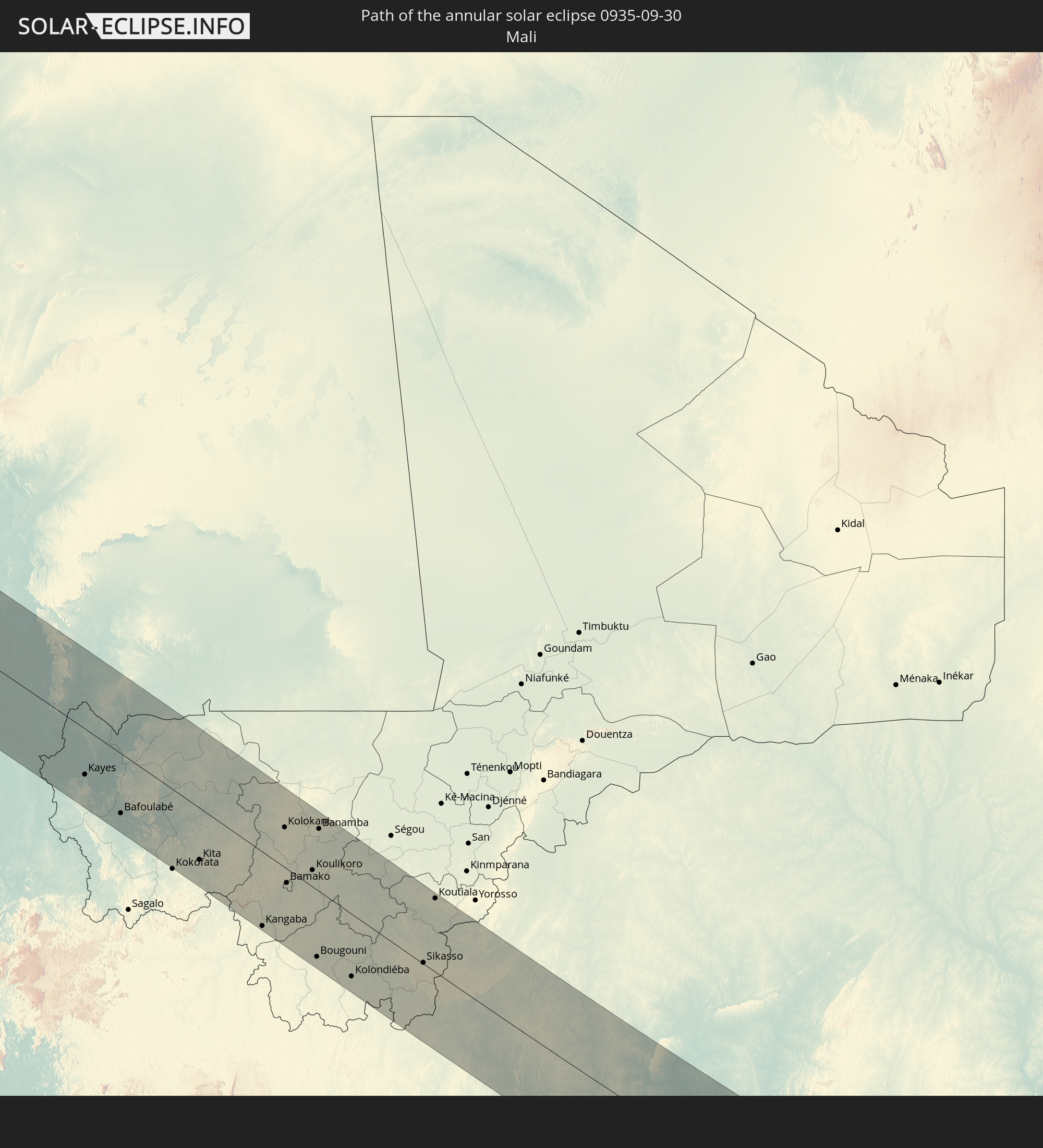
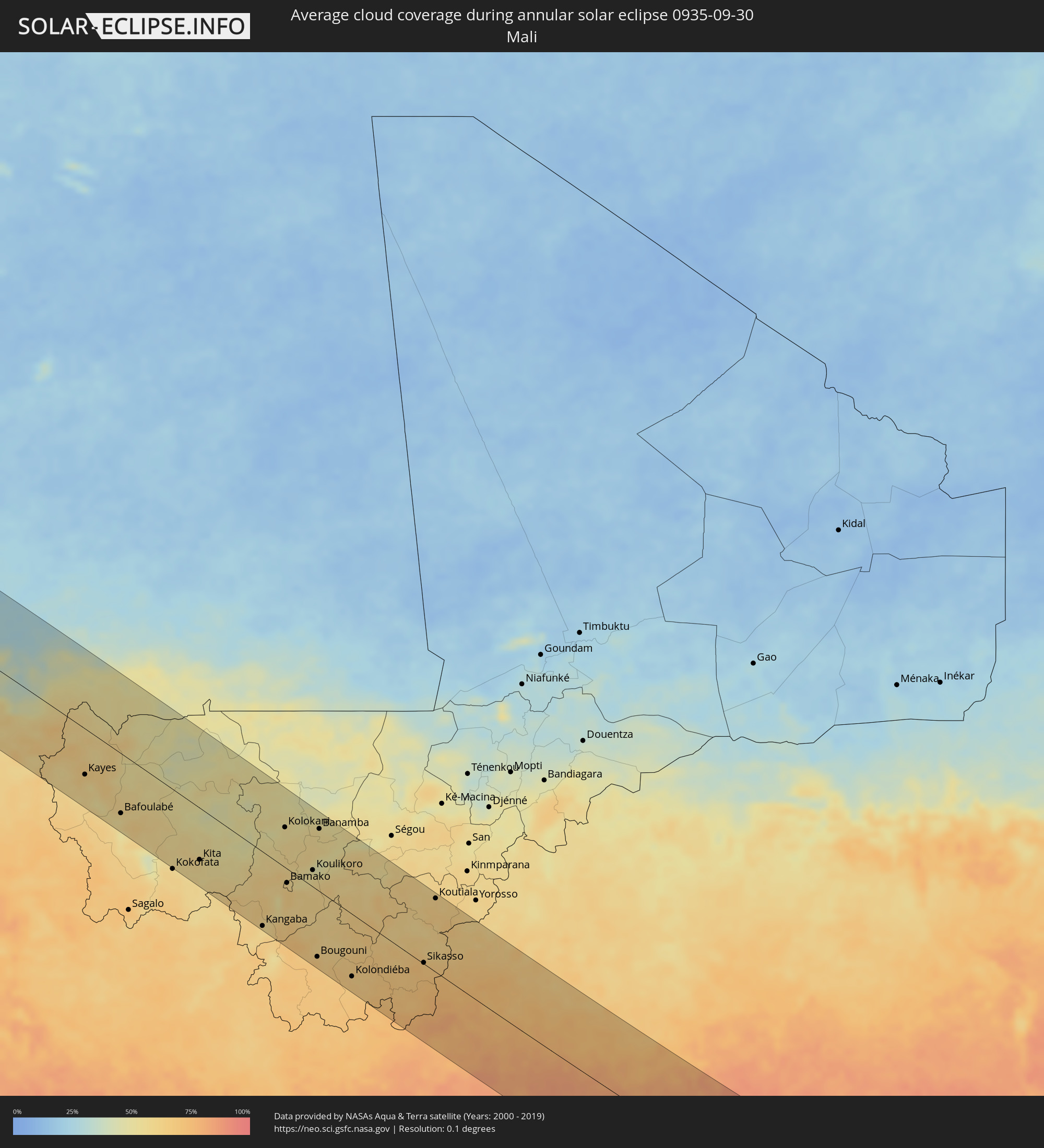 Mali
Mali
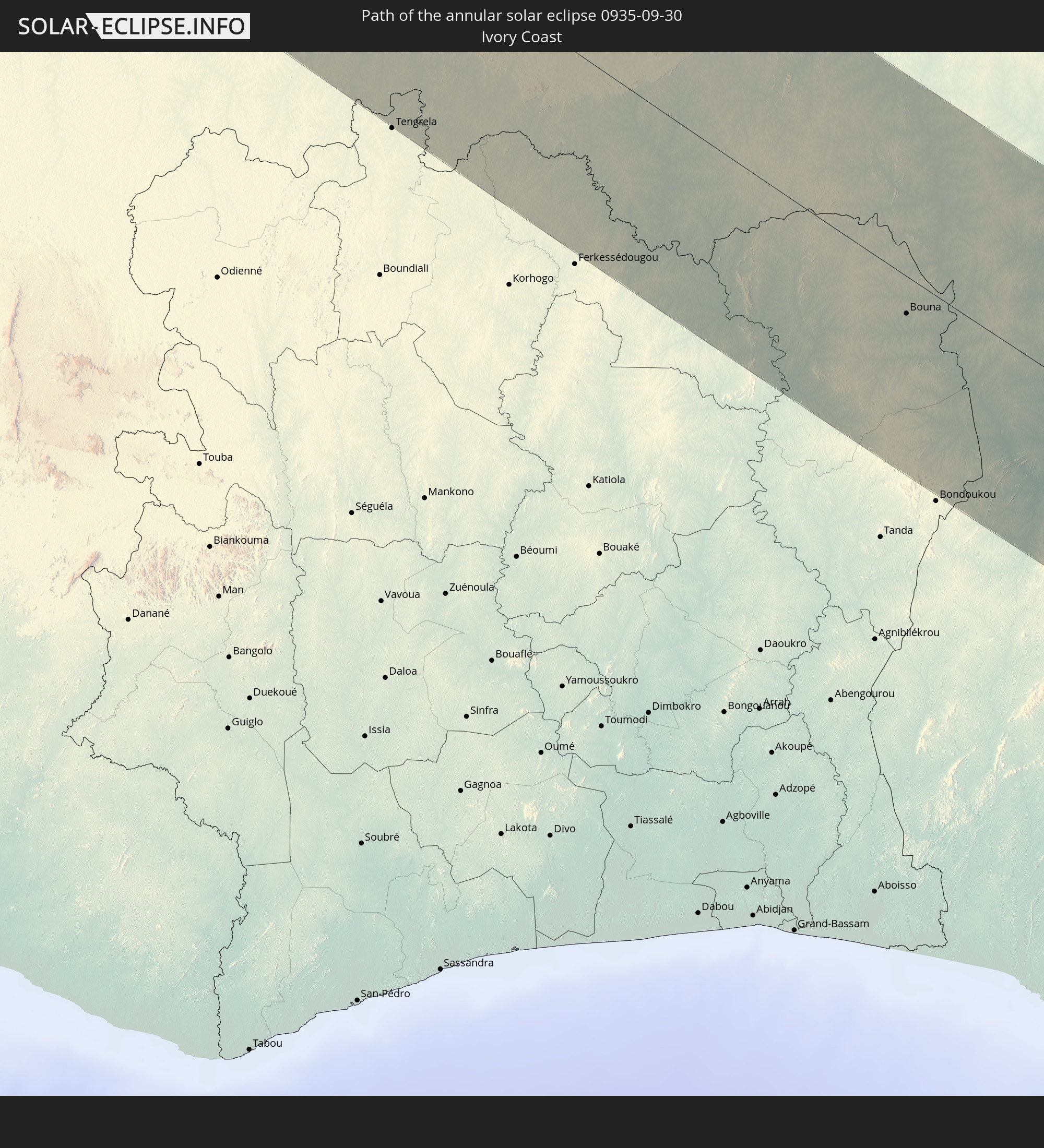
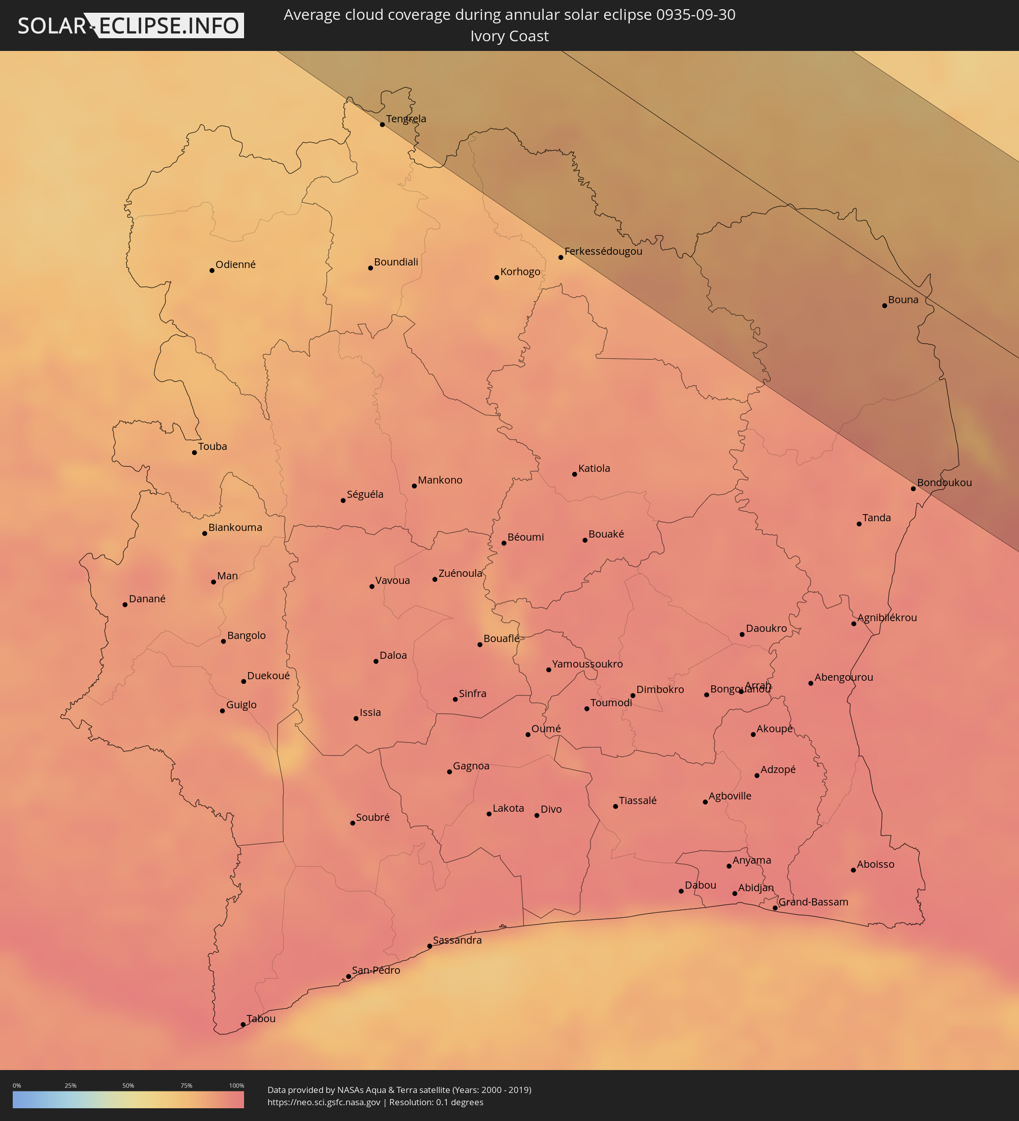 Ivory Coast
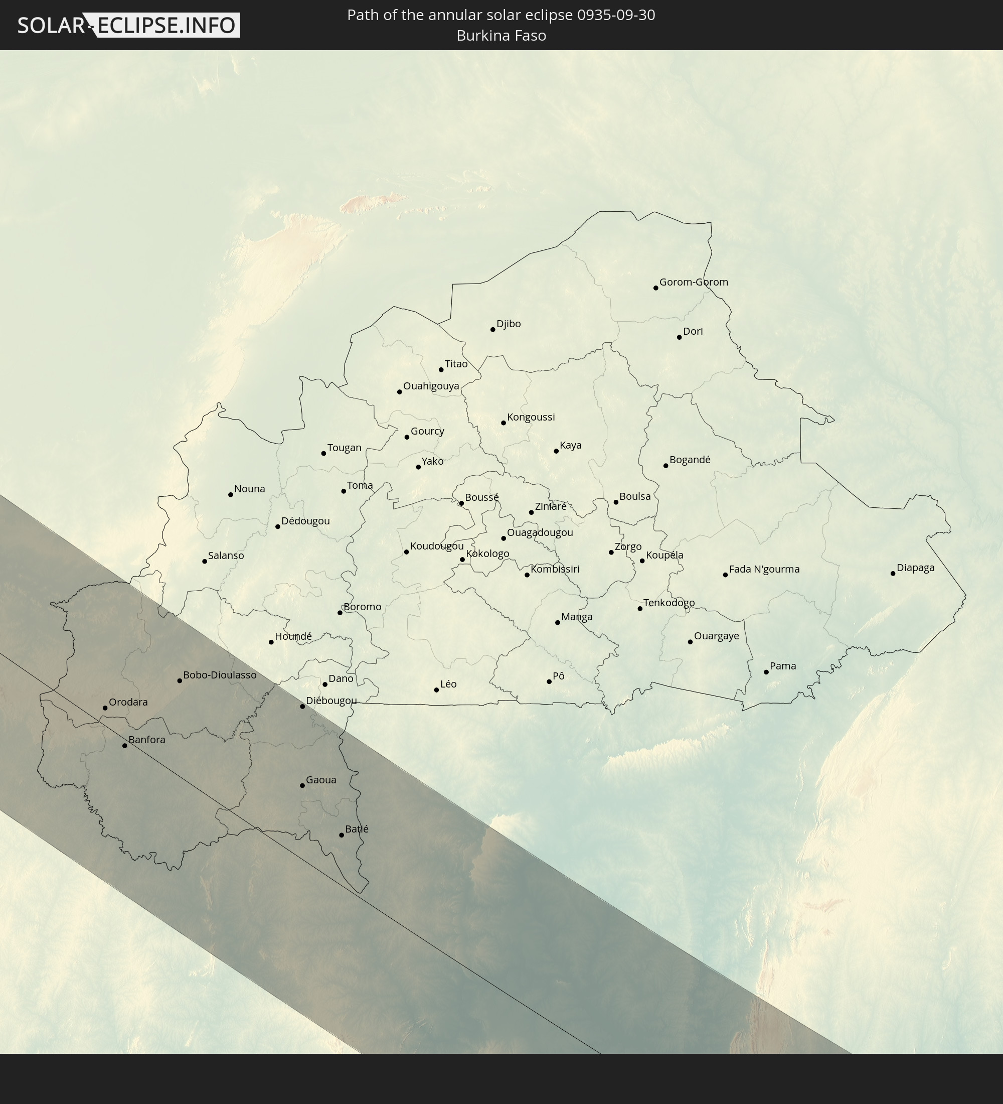
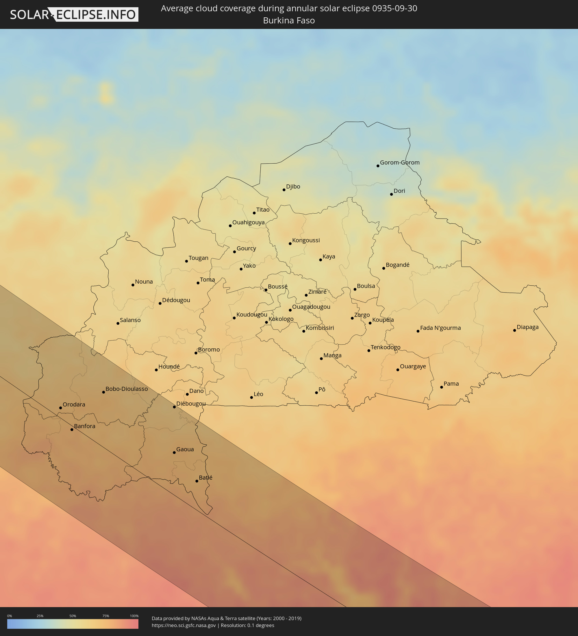 Burkina Faso
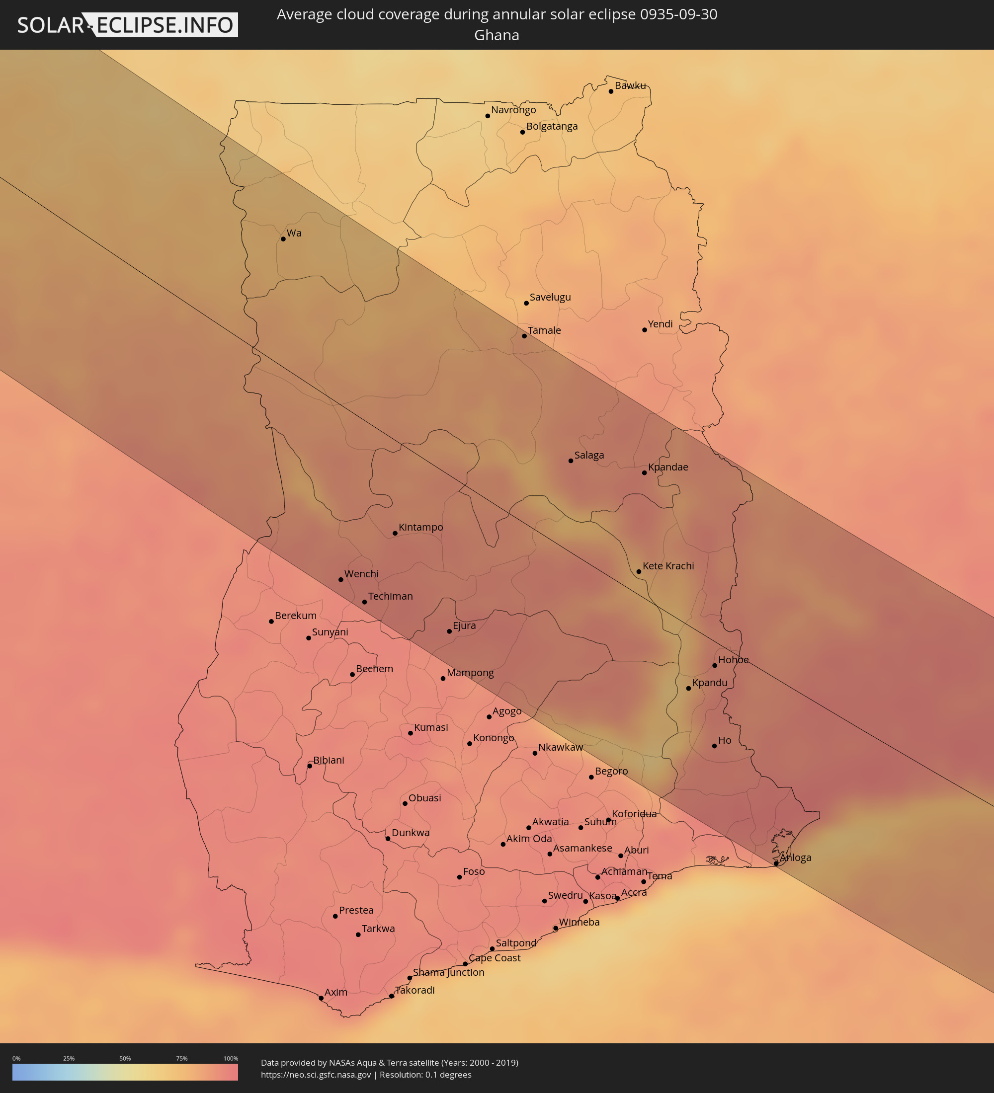 Ghana
Ghana
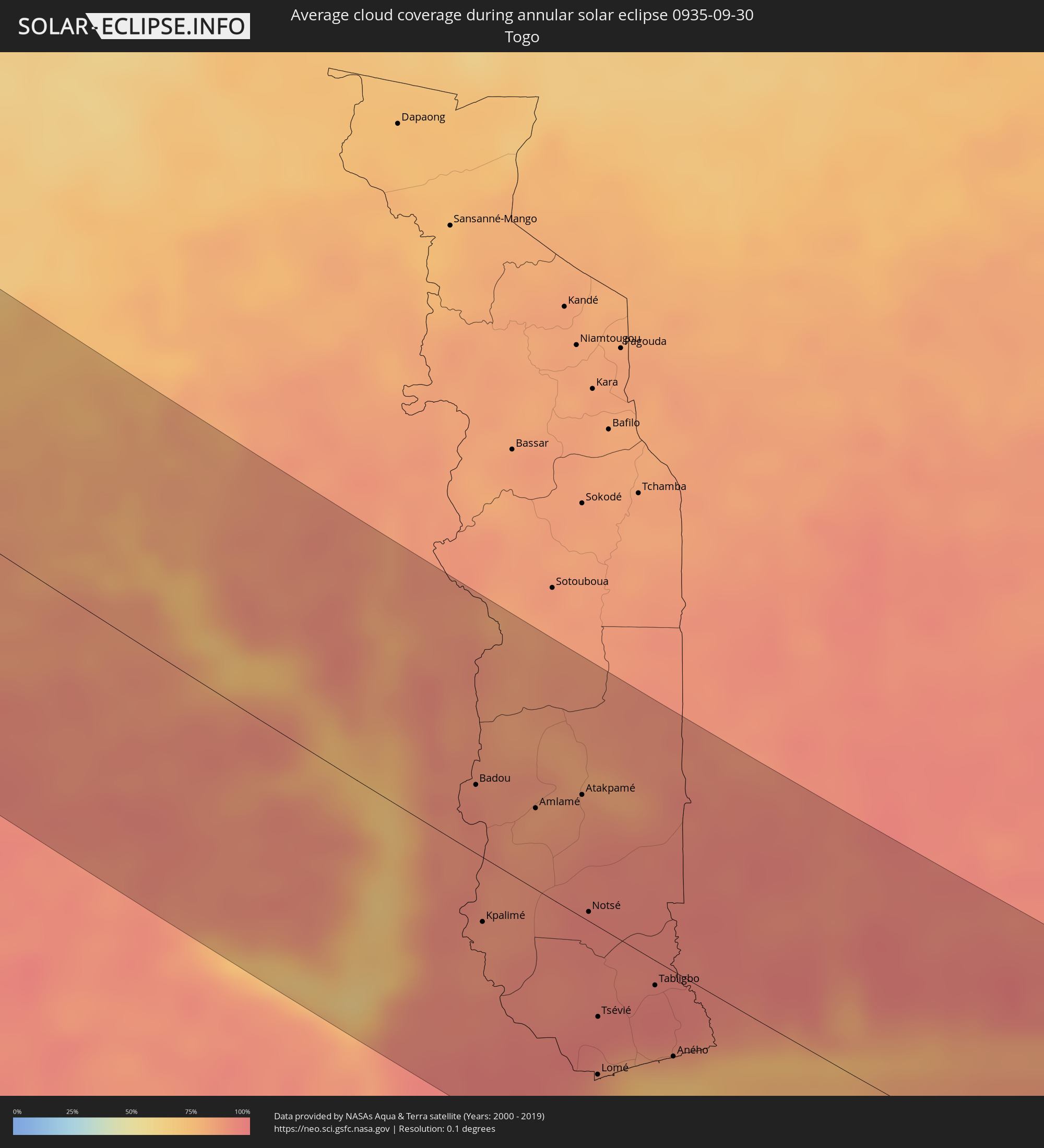 Togo
Togo
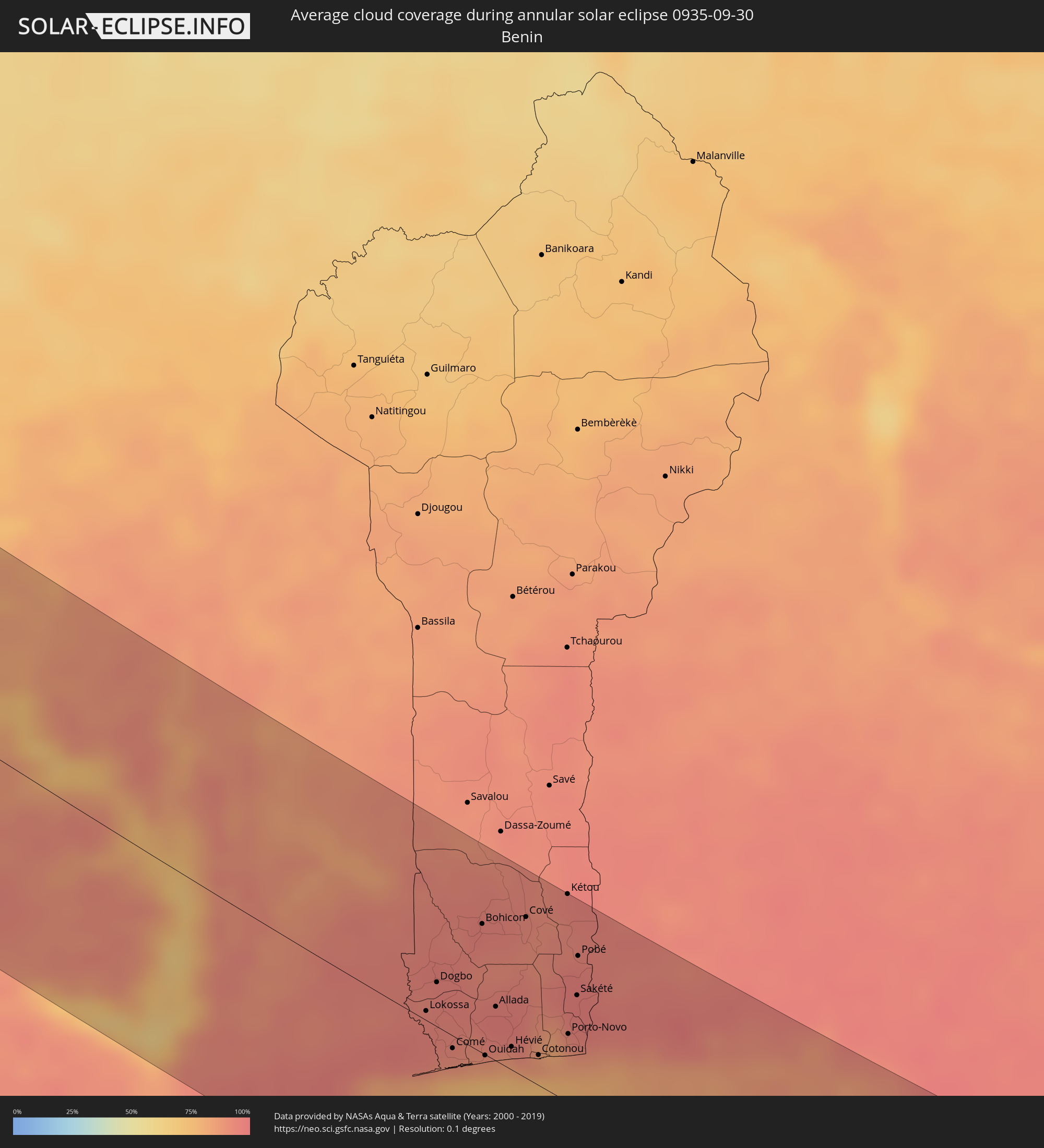 Benin
Benin
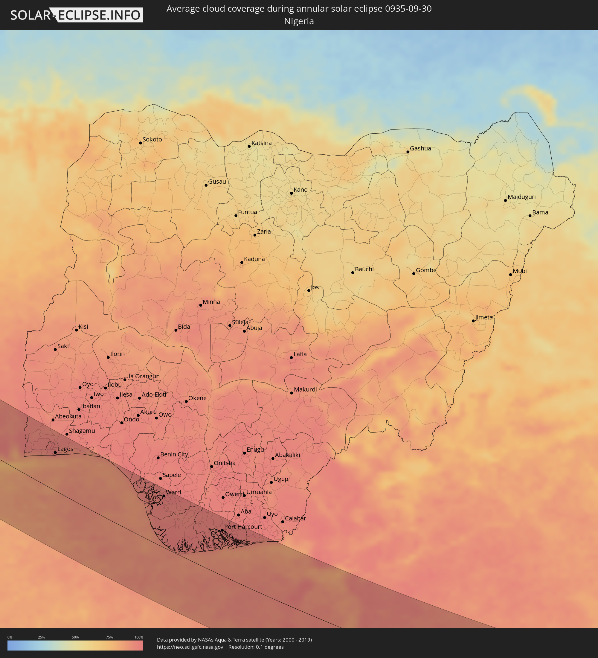 Nigeria
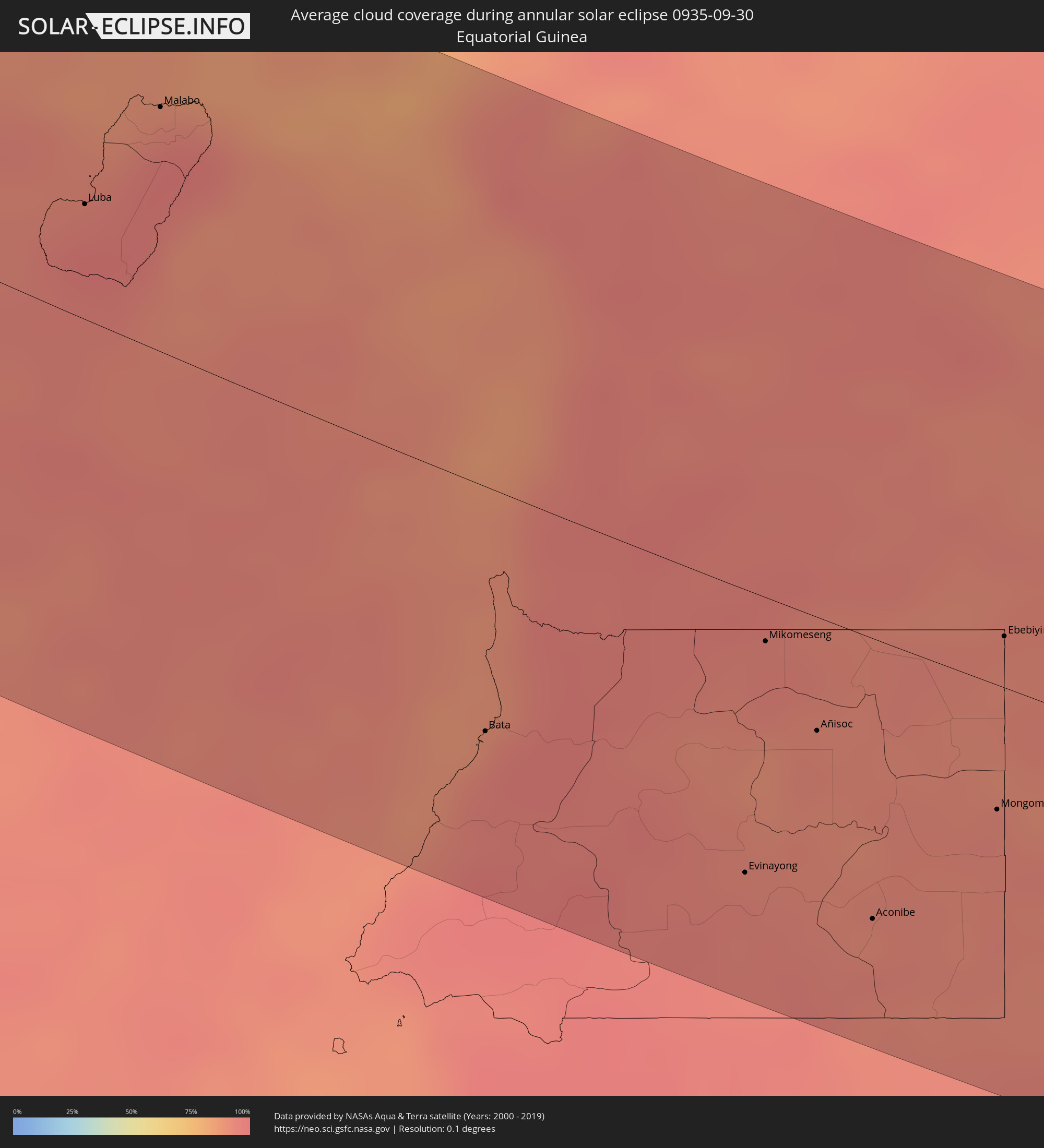 Equatorial Guinea
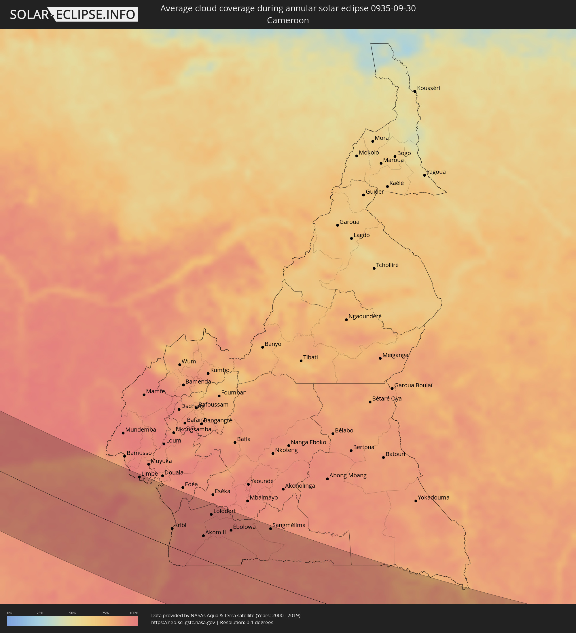 Cameroon
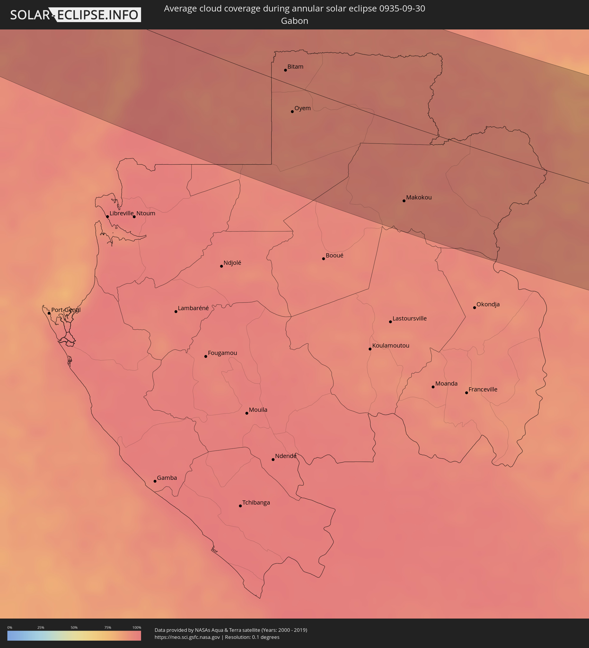 Gabon
Gabon
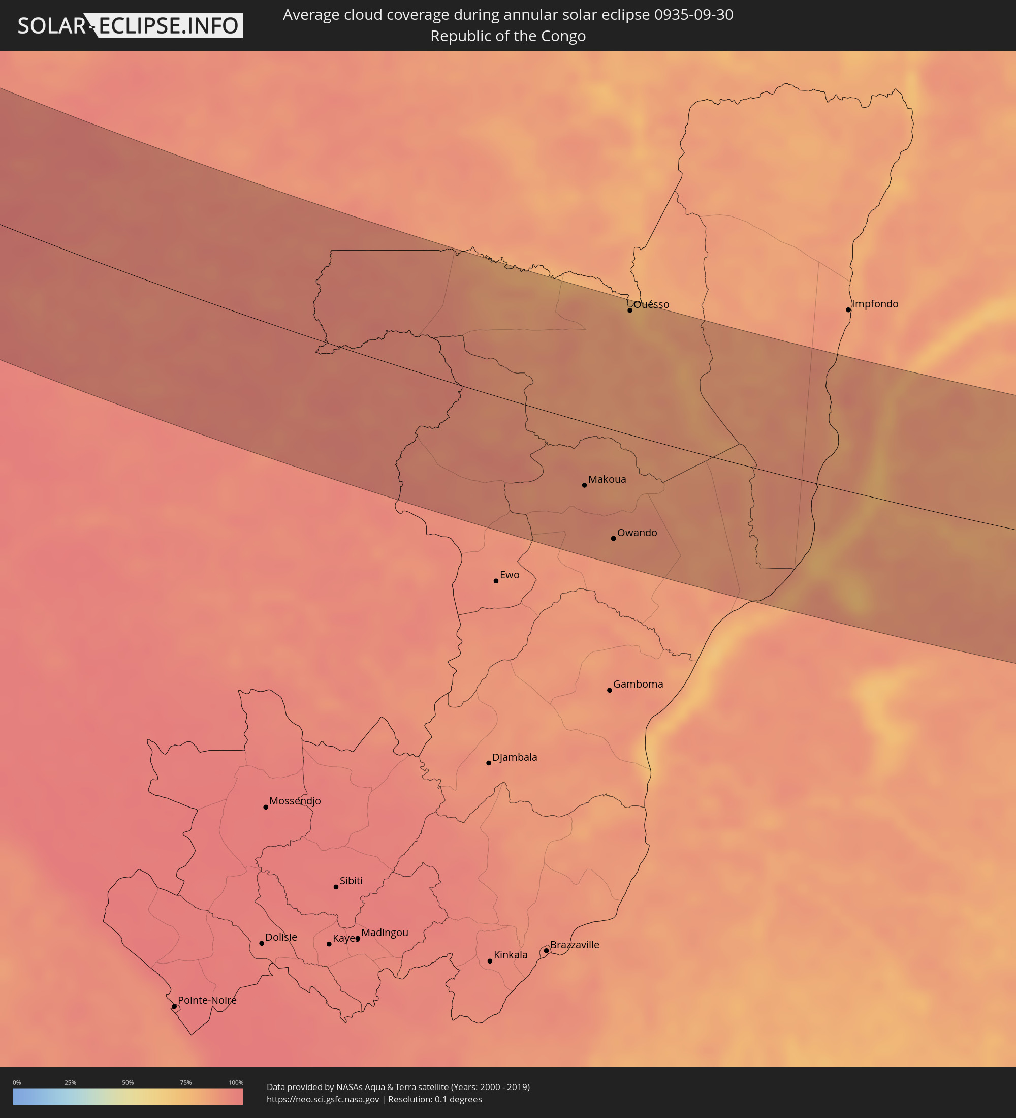 Republic of the Congo
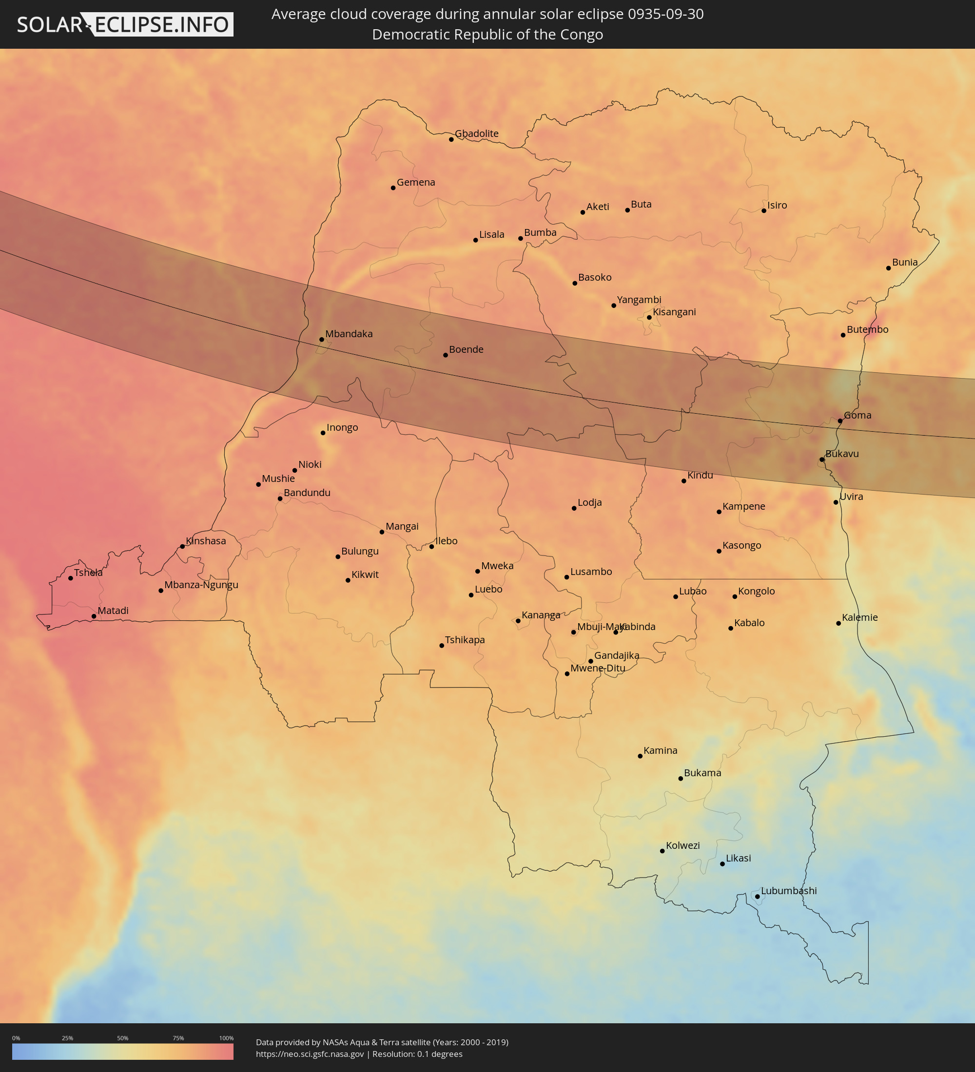 Democratic Republic of the Congo
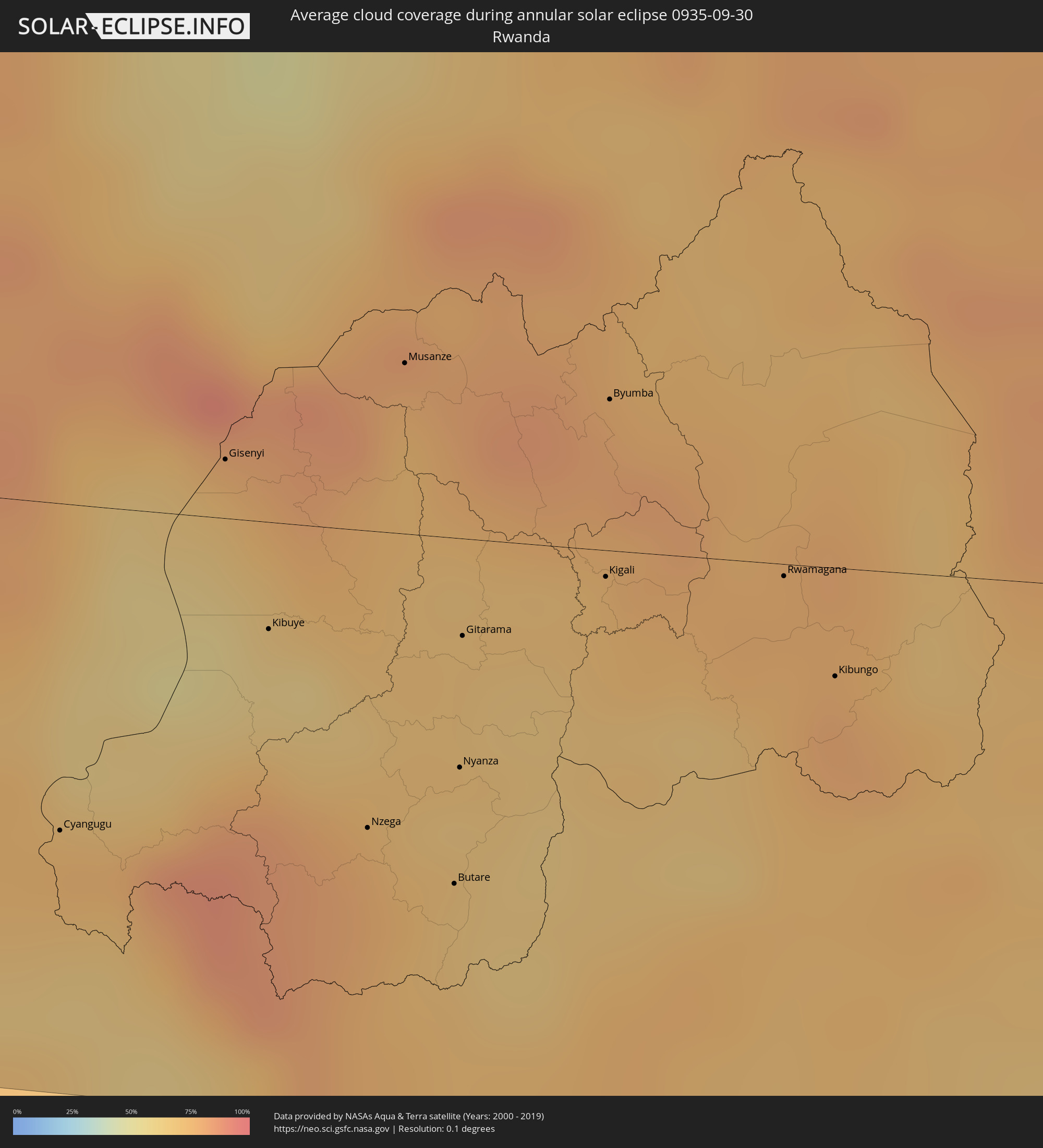 Rwanda
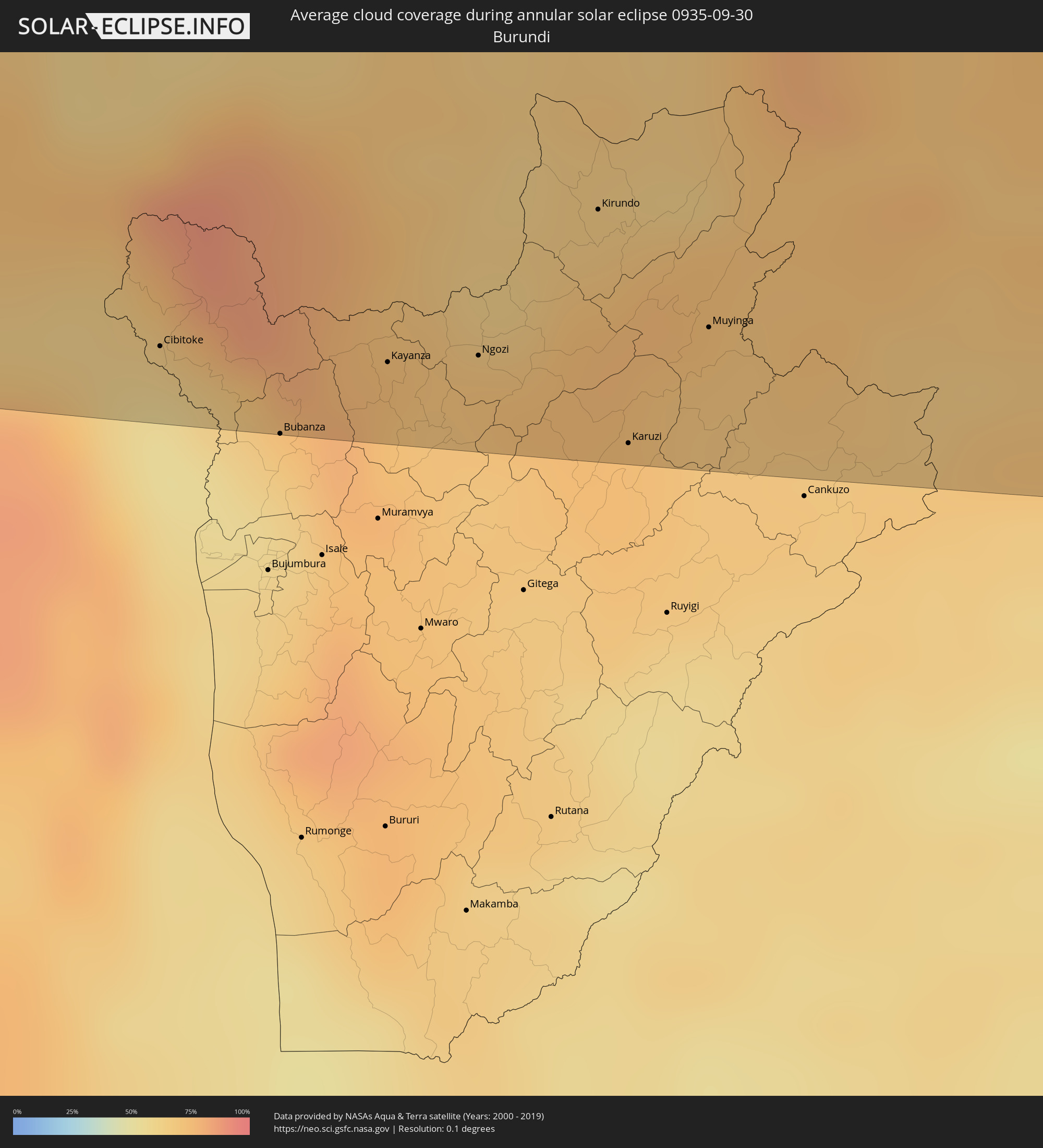 Burundi
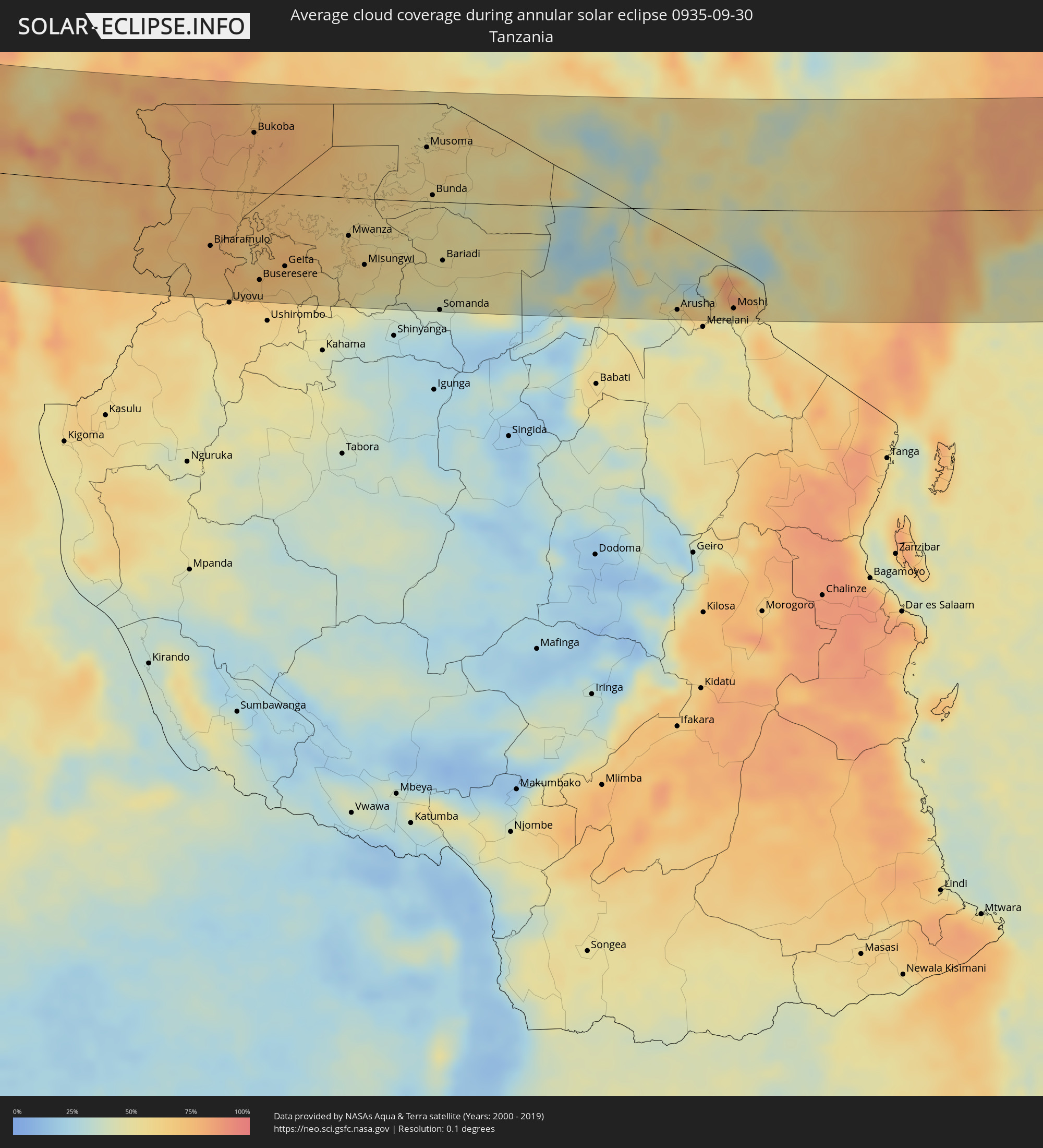 Tanzania
 Uganda
 Kenya
Kenya
 Somalia
Cities inside the path of the eclipse
The following table shows all locations with a population of more than 5,000 inside the eclipse path. Cities which have more than 100,000 inhabitants are marked bold. A click at the locations opens a detailed map.
| City | Type | Eclipse duration | Local time of max. eclipse | Distance to central line | Ø Cloud coverage |
|
Hamilton, Hamilton city
|
annular | - | 06:13:02 UTC-04:19 | 71 km | 72% |
|
Tevragh Zeina, Nouakchott
|
annular | - | 11:21:54 UTC-00:16 | 1 km | 44% |
|
Nouakchott, Nouakchott
|
annular | - | 11:21:57 UTC-00:16 | 0 km | 44% |
|
Tékane, Trarza
|
annular | - | 11:25:35 UTC-00:16 | 111 km | 44% |
|
Ndioum, Saint-Louis
|
annular | - | 11:27:54 UTC-00:16 | 70 km | 39% |
|
Goléré, Saint-Louis
|
annular | - | 11:29:49 UTC-00:16 | 62 km | 44% |
|
Aleg, Brakna
|
annular | - | 11:29:04 UTC-00:16 | 23 km | 35% |
|
Kaédi, Gorgol
|
annular | - | 11:31:40 UTC-00:16 | 36 km | 42% |
|
Ouro Sogui, Matam
|
annular | - | 11:33:04 UTC-00:16 | 76 km | 56% |
|
Matam, Matam
|
annular | - | 11:33:11 UTC-00:16 | 67 km | 50% |
|
Kanel, Matam
|
annular | - | 11:33:41 UTC-00:16 | 78 km | 59% |
|
Sémé, Matam
|
annular | - | 11:34:50 UTC-00:16 | 91 km | 61% |
|
Waoundé, Matam
|
annular | - | 11:34:56 UTC-00:16 | 80 km | 59% |
|
Diawara, Matam
|
annular | - | 11:36:17 UTC-00:16 | 83 km | 62% |
|
Sélibaby, Guidimaka
|
annular | - | 11:37:05 UTC-00:16 | 49 km | 62% |
|
Kayes, Kayes
|
annular | - | 11:40:29 UTC-00:16 | 69 km | 58% |
|
Bafoulabé, Kayes
|
annular | - | 11:43:26 UTC-00:16 | 91 km | 54% |
|
Kati, Koulikoro
|
annular | - | 11:53:45 UTC-00:16 | 17 km | 59% |
|
Kolokani, Koulikoro
|
annular | - | 11:52:16 UTC-00:16 | 61 km | 54% |
|
Bamako, Bamako
|
annular | - | 11:54:09 UTC-00:16 | 21 km | 61% |
|
Koulikoro, Koulikoro
|
annular | - | 11:55:05 UTC-00:16 | 25 km | 53% |
|
Bougouni, Sikasso
|
annular | - | 11:58:10 UTC-00:16 | 102 km | 68% |
|
Banamba, Koulikoro
|
annular | - | 11:54:06 UTC-00:16 | 95 km | 55% |
|
Sikasso, Sikasso
|
annular | - | 12:04:00 UTC-00:16 | 2 km | 69% |
|
Koutiala, Sikasso
|
annular | - | 12:02:28 UTC-00:16 | 113 km | 64% |
|
Orodara, Hauts-Bassins
|
annular | - | 12:07:02 UTC-00:16 | 13 km | 74% |
|
Banfora, Cascades
|
annular | - | 12:08:12 UTC-00:16 | 5 km | 78% |
|
Bobo-Dioulasso, Hauts-Bassins
|
annular | - | 12:08:33 UTC-00:16 | 74 km | 74% |
|
Gaoua, Sud-Ouest
|
annular | - | 12:13:38 UTC-00:16 | 57 km | 74% |
|
Diébougou, Sud-Ouest
|
annular | - | 12:12:16 UTC-00:16 | 118 km | 65% |
|
Bouna, Zanzan
|
annular | - | 12:16:33 UTC-00:16 | 23 km | 83% |
|
Batié, Sud-Ouest
|
annular | - | 12:15:32 UTC-00:16 | 39 km | 75% |
|
Wa, Upper West
|
annular | - | 12:31:44 UTC-00:00 | 81 km | 75% |
|
Wenchi, Brong-Ahafo
|
annular | - | 12:37:47 UTC-00:00 | 112 km | 94% |
|
Techiman, Brong-Ahafo
|
annular | - | 12:38:37 UTC-00:00 | 116 km | 93% |
|
Kintampo, Brong-Ahafo
|
annular | - | 12:38:18 UTC-00:00 | 60 km | 92% |
|
Ejura, Ashanti
|
annular | - | 12:40:52 UTC-00:00 | 100 km | 92% |
|
Tamale, Northern
|
annular | - | 12:38:19 UTC-00:00 | 119 km | 84% |
|
Kpandu, Volta
|
annular | - | 12:46:47 UTC-00:00 | 41 km | 84% |
|
Ho, Volta
|
annular | - | 12:48:09 UTC-00:00 | 68 km | 93% |
|
Hohoe, Volta
|
annular | - | 12:47:02 UTC-00:00 | 16 km | 90% |
|
Badou, Plateaux
|
annular | - | 12:31:16 UTC-00:16 | 32 km | 92% |
|
Kpalimé, Plateaux
|
annular | - | 12:32:46 UTC-00:16 | 31 km | 90% |
|
Anloga, Volta
|
annular | - | 12:51:05 UTC-00:00 | 121 km | 72% |
|
Amlamé, Plateaux
|
annular | - | 12:32:27 UTC-00:16 | 39 km | 84% |
|
Atakpamé, Plateaux
|
annular | - | 12:33:02 UTC-00:16 | 58 km | 87% |
|
Notsé, Plateaux
|
annular | - | 12:34:19 UTC-00:16 | 4 km | 95% |
|
Lomé, Maritime
|
annular | - | 12:36:06 UTC-00:16 | 71 km | 72% |
|
Tsévié, Maritime
|
annular | - | 12:35:31 UTC-00:16 | 43 km | 96% |
|
Tabligbo, Maritime
|
annular | - | 12:36:05 UTC-00:16 | 12 km | 96% |
|
Vogan, Maritime
|
annular | - | 12:36:41 UTC-00:16 | 34 km | 83% |
|
Aného, Maritime
|
annular | - | 12:37:05 UTC-00:16 | 41 km | 72% |
|
Lokossa, Mono
|
annular | - | 13:06:21 UTC+00:13 | 6 km | 95% |
|
Dogbo, Kouffo
|
annular | - | 13:06:12 UTC+00:13 | 26 km | 95% |
|
Comé, Mono
|
annular | - | 13:07:19 UTC+00:13 | 7 km | 88% |
|
Bohicon, Zou
|
annular | - | 13:06:20 UTC+00:13 | 77 km | 95% |
|
Ouidah, Atlantique
|
annular | - | 13:08:02 UTC+00:13 | 1 km | 85% |
|
Cové, Zou
|
annular | - | 13:07:05 UTC+00:13 | 96 km | 93% |
|
Cotonou, Littoral
|
annular | - | 13:09:02 UTC+00:13 | 18 km | 86% |
|
Porto-Novo, Ouémé
|
annular | - | 13:09:21 UTC+00:13 | 41 km | 89% |
|
Sakété, Plateau
|
annular | - | 13:09:02 UTC+00:13 | 67 km | 97% |
|
Pobé, Plateau
|
annular | - | 13:08:34 UTC+00:13 | 91 km | 95% |
|
Ilaro, Ogun
|
annular | - | 13:09:49 UTC+00:13 | 101 km | 94% |
|
Ifo, Ogun
|
annular | - | 13:10:30 UTC+00:13 | 104 km | 96% |
|
Ikeja, Lagos
|
annular | - | 13:11:23 UTC+00:13 | 91 km | 97% |
|
Lagos, Lagos
|
annular | - | 13:11:49 UTC+00:13 | 80 km | 94% |
|
Ebute Ikorodu, Lagos
|
annular | - | 13:11:49 UTC+00:13 | 99 km | 91% |
|
Epe, Lagos
|
annular | - | 13:13:20 UTC+00:13 | 124 km | 92% |
|
Warri, Delta
|
annular | - | 13:20:38 UTC+00:13 | 110 km | 97% |
|
Ughelli, Delta
|
annular | - | 13:21:25 UTC+00:13 | 120 km | 97% |
|
Buguma, Rivers
|
annular | - | 13:25:17 UTC+00:13 | 87 km | 96% |
|
Port Harcourt, Rivers
|
annular | - | 13:25:38 UTC+00:13 | 98 km | 96% |
|
Luba, Bioko Sur
|
annular | - | 13:32:17 UTC+00:13 | 35 km | 96% |
|
Malabo, Bioko Norte
|
annular | - | 13:32:23 UTC+00:13 | 76 km | 93% |
|
Rebola, Bioko Norte
|
annular | - | 13:32:35 UTC+00:13 | 74 km | 97% |
|
Limbe, South-West
|
annular | - | 13:33:05 UTC+00:13 | 122 km | 87% |
|
Bata, Litoral
|
annular | - | 13:38:10 UTC+00:13 | 76 km | 94% |
|
Kribi, South
|
annular | - | 13:36:46 UTC+00:13 | 40 km | 88% |
|
Dizangué, Littoral
|
annular | - | 13:35:35 UTC+00:13 | 129 km | 91% |
|
Evinayong, Centro Sur
|
annular | - | 13:40:52 UTC+00:13 | 89 km | 94% |
|
Akom II, South
|
annular | - | 13:38:45 UTC+00:13 | 51 km | 94% |
|
Mikomeseng, Kié-Ntem
|
annular | - | 13:39:55 UTC+00:13 | 14 km | 95% |
|
Lolodorf, South
|
annular | - | 13:38:26 UTC+00:13 | 105 km | 94% |
|
Añisoc, Wele-Nzas
|
annular | - | 13:40:45 UTC+00:13 | 36 km | 92% |
|
Aconibe, Wele-Nzas
|
annular | - | 13:42:04 UTC+00:13 | 88 km | 91% |
|
Ébolowa, South
|
annular | - | 13:40:03 UTC+00:13 | 87 km | 91% |
|
Ambam, South
|
annular | - | 13:41:13 UTC+00:13 | 38 km | 91% |
|
Mongomo, Wele-Nzas
|
annular | - | 13:42:29 UTC+00:13 | 39 km | 93% |
|
Ebebiyin, Kié-Ntem
|
annular | - | 13:41:43 UTC+00:13 | 16 km | 93% |
|
Bitam, Woleu-Ntem
|
annular | - | 13:42:15 UTC+00:13 | 15 km | 93% |
|
Oyem, Woleu-Ntem
|
annular | - | 13:43:11 UTC+00:13 | 32 km | 91% |
|
Sangmélima, South
|
annular | - | 13:42:06 UTC+00:13 | 123 km | 91% |
|
Makokou, Ogooué-Ivindo
|
annular | - | 13:47:50 UTC+00:13 | 93 km | 91% |
|
Makoua, Cuvette
|
annular | - | 13:54:52 UTC+00:13 | 63 km | 91% |
|
Owando, Cuvette
|
annular | - | 13:56:05 UTC+00:13 | 107 km | 88% |
|
Ouésso, Sangha
|
annular | - | 13:53:36 UTC+00:13 | 122 km | 78% |
|
Mbandaka, Équateur
|
annular | - | 14:00:15 UTC+00:13 | 15 km | 81% |
|
Boende, Équateur
|
annular | - | 14:05:34 UTC+00:13 | 41 km | 84% |
|
Kabare, South Kivu
|
annular | - | 16:16:09 UTC+02:10 | 79 km | 71% |
|
Bukavu, South Kivu
|
annular | - | 16:16:13 UTC+02:10 | 78 km | 71% |
|
Cyangugu, Western Province
|
annular | - | 16:16:17 UTC+02:10 | 76 km | 70% |
|
Sake, Nord Kivu
|
annular | - | 16:15:42 UTC+02:10 | 26 km | 65% |
|
Cibitoke, Cibitoke
|
annular | - | 16:16:52 UTC+02:10 | 119 km | 54% |
|
Goma, Nord Kivu
|
annular | - | 16:16:00 UTC+02:10 | 17 km | 66% |
|
Gisenyi, Western Province
|
annular | - | 16:16:04 UTC+02:10 | 14 km | 73% |
|
Kibuye, Western Province
|
annular | - | 16:16:28 UTC+02:10 | 25 km | 64% |
|
Bubanza, Bubanza
|
annular | - | 16:17:19 UTC+02:10 | 138 km | 63% |
|
Kayanza, Kayanza
|
annular | - | 16:17:28 UTC+02:10 | 118 km | 73% |
|
Musanze, Northern Province
|
annular | - | 16:16:20 UTC+02:10 | 40 km | 73% |
|
Ntungamo, Western Region
|
annular | - | 16:32:46 UTC+02:27 | 108 km | 76% |
|
Kisoro, Western Region
|
annular | - | 16:33:09 UTC+02:27 | 64 km | 78% |
|
Butare, Southern Province
|
annular | - | 16:17:20 UTC+02:10 | 81 km | 68% |
|
Gitarama, Southern Province
|
annular | - | 16:16:57 UTC+02:10 | 23 km | 66% |
|
Kanungu, Western Region
|
annular | - | 16:33:00 UTC+02:27 | 101 km | 84% |
|
Ngozi, Ngozi
|
annular | - | 16:17:41 UTC+02:10 | 115 km | 71% |
|
Rukungiri, Western Region
|
annular | - | 16:33:05 UTC+02:27 | 116 km | 71% |
|
Kabale, Western Region
|
annular | - | 16:33:28 UTC+02:27 | 71 km | 77% |
|
Kigali, Kigali
|
annular | - | 16:17:12 UTC+02:10 | 6 km | 74% |
|
Byumba, Northern Province
|
annular | - | 16:16:54 UTC+02:10 | 35 km | 81% |
|
Kirundo, Kirundo
|
annular | - | 16:17:44 UTC+02:10 | 76 km | 72% |
|
Karuzi, Karuzi
|
annular | - | 16:18:12 UTC+02:10 | 133 km | 71% |
|
Ntungamo, Western Region
|
annular | - | 16:33:29 UTC+02:27 | 114 km | 75% |
|
Muyinga, Muyinga
|
annular | - | 16:18:12 UTC+02:10 | 103 km | 71% |
|
Nyachera, Western Region
|
annular | - | 16:33:40 UTC+02:27 | 113 km | 74% |
|
Rwamagana, Eastern Province
|
annular | - | 16:17:37 UTC+02:10 | 3 km | 76% |
|
Kibungo, Eastern Province
|
annular | - | 16:17:54 UTC+02:10 | 25 km | 78% |
|
Biharamulo, Kagera
|
annular | - | 16:36:00 UTC+02:27 | 72 km | 77% |
|
Byakabanda, Central Region
|
annular | - | 16:34:38 UTC+02:27 | 139 km | 80% |
|
Bukoba, Kagera
|
annular | - | 16:35:32 UTC+02:27 | 76 km | 78% |
|
Buseresere, Geita
|
annular | - | 16:36:52 UTC+02:27 | 111 km | 70% |
|
Geita, Geita
|
annular | - | 16:37:02 UTC+02:27 | 92 km | 68% |
|
Mwanza, Mwanza
|
annular | - | 16:37:30 UTC+02:27 | 49 km | 64% |
|
Misungwi, Mwanza
|
annular | - | 16:37:54 UTC+02:27 | 85 km | 55% |
|
Musoma, Mara
|
annular | - | 16:37:36 UTC+02:27 | 69 km | 57% |
|
Bunda, Mara
|
annular | - | 16:38:04 UTC+02:27 | 8 km | 52% |
|
Migori, Migori
|
annular | - | 16:37:53 UTC+02:27 | 121 km | 56% |
|
Narok, Narok
|
annular | - | 16:39:04 UTC+02:27 | 124 km | 39% |
|
Arusha, Arusha
|
annular | - | 16:41:13 UTC+02:27 | 129 km | 47% |
|
Nairobi, Nairobi Area
|
annular | - | 16:39:57 UTC+02:27 | 103 km | 54% |
|
Athi River, Machakos
|
annular | - | 16:40:12 UTC+02:27 | 84 km | 57% |
|
Thika, Nairobi Area
|
annular | - | 16:39:58 UTC+02:27 | 132 km | 60% |
|
Machakos, Machakos
|
annular | - | 16:40:27 UTC+02:27 | 78 km | 51% |
|
Moshi, Kilimanjaro
|
annular | - | 16:41:40 UTC+02:27 | 126 km | 49% |
|
Mbale, Vihiga
|
annular | - | 16:42:23 UTC+02:27 | 131 km | 66% |
|
Voi, Taita Taveta
|
annular | - | 16:42:29 UTC+02:27 | 130 km | 66% |
|
Malindi, Kilifi
|
annular | - | 16:43:18 UTC+02:27 | 111 km | 64% |
|
Lamu, Lamu
|
annular | - | 16:43:11 UTC+02:27 | 6 km | 47% |