Total solar eclipse of 04/27/0990
| Day of week: | Tuesday |
| Maximum duration of eclipse: | 05m45s |
| Maximum width of eclipse path: | 349 km |
| Saros cycle: | 112 |
| Coverage: | 100% |
| Magnitude: | 1.07 |
| Gamma: | -0.7599 |
Wo kann man die Sonnenfinsternis vom 04/27/0990 sehen?
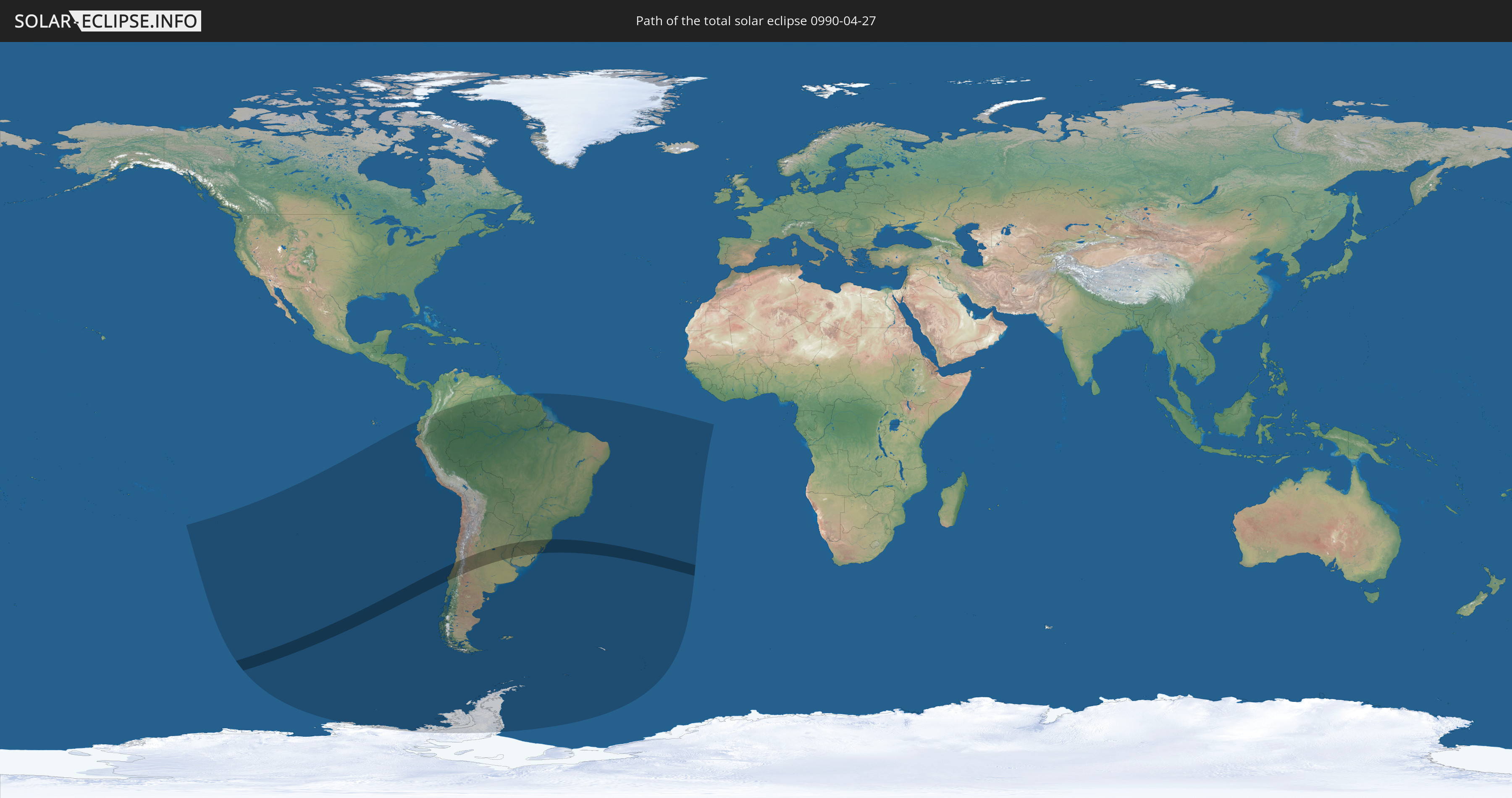
Die Sonnenfinsternis am 04/27/0990 kann man in 18 Ländern als partielle Sonnenfinsternis beobachten.
Der Finsternispfad verläuft durch 4 Länder. Nur in diesen Ländern ist sie als total Sonnenfinsternis zu sehen.
In den folgenden Ländern ist die Sonnenfinsternis total zu sehen
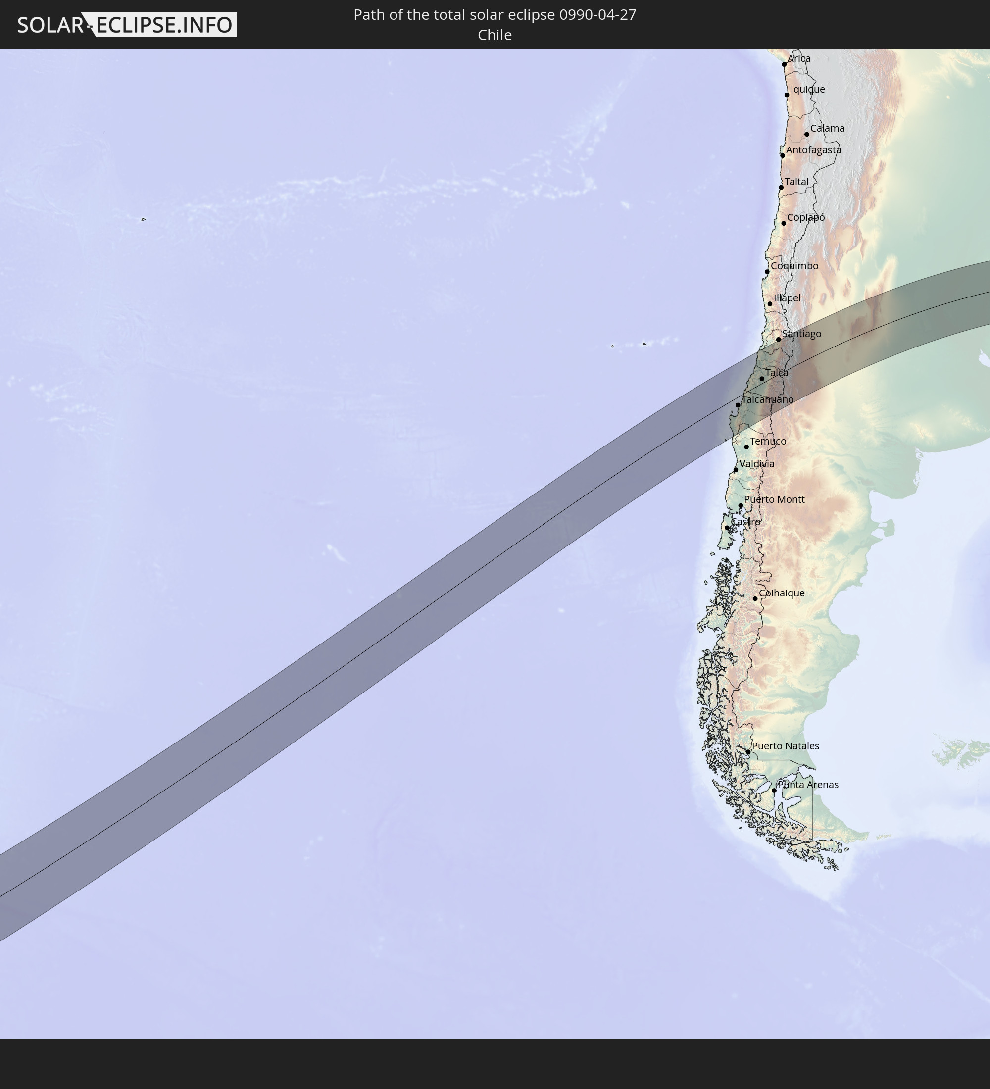 Chile
Chile
 Brazil
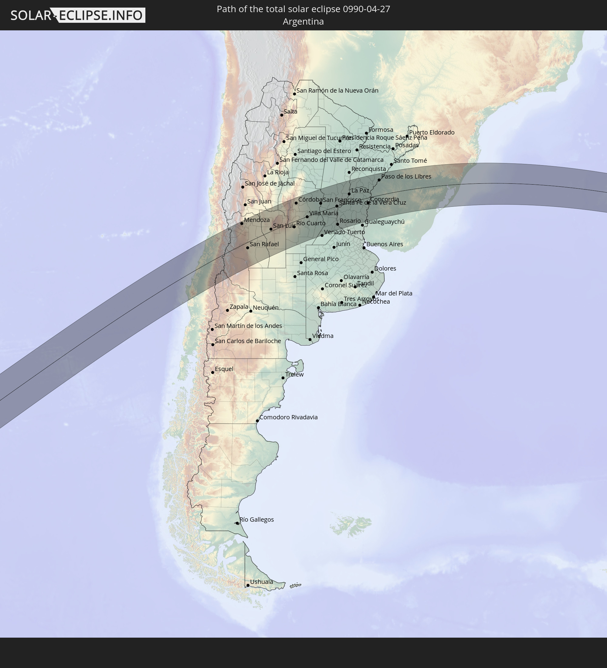 Argentina
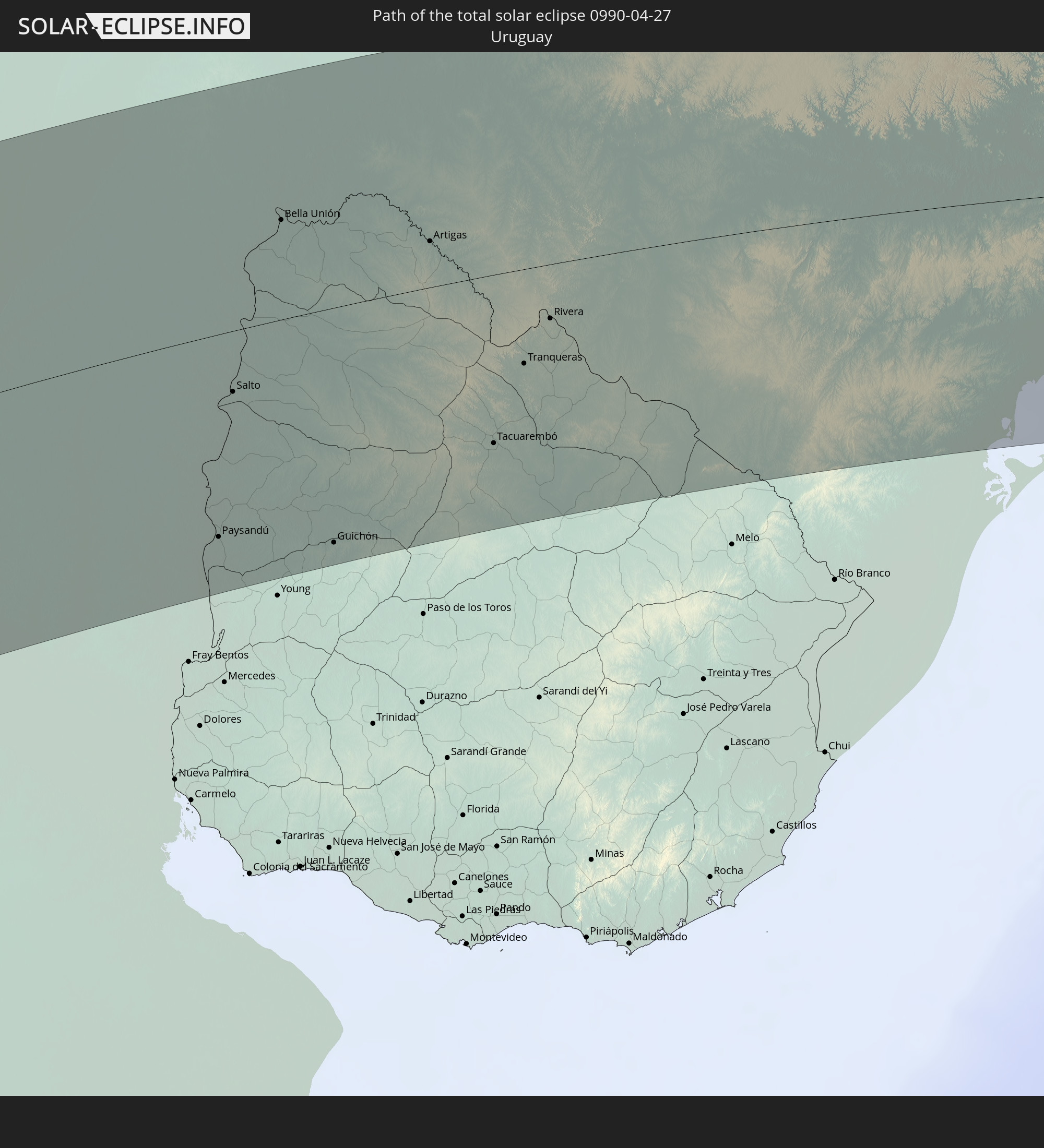 Uruguay
In den folgenden Ländern ist die Sonnenfinsternis partiell zu sehen


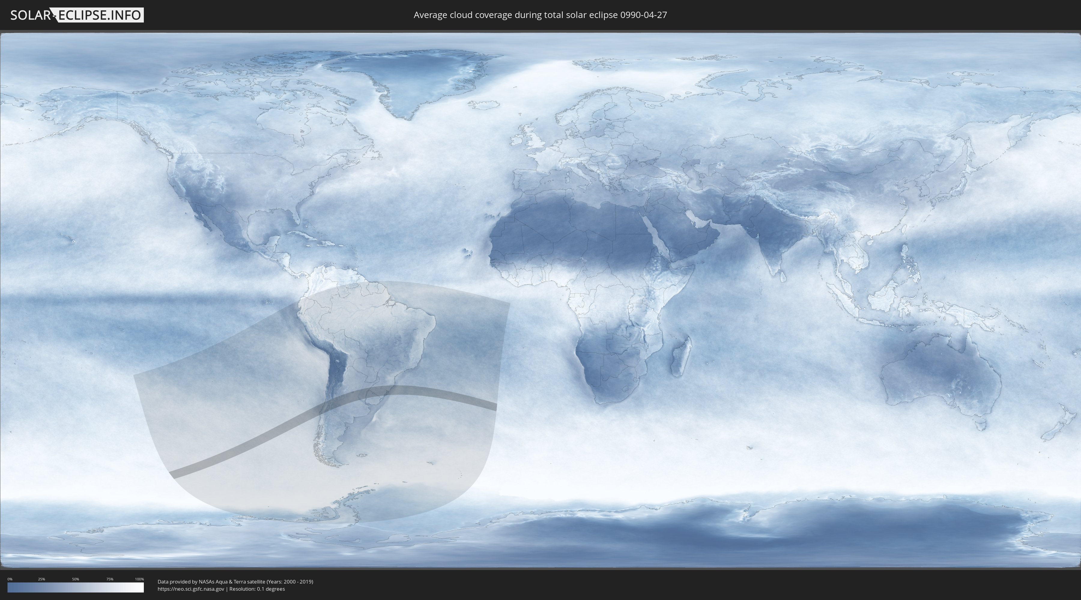
How will be the weather during the total solar eclipse on 04/27/0990?
Where is the best place to see the total solar eclipse of 04/27/0990?
The following maps show the average cloud coverage for the day of the total solar eclipse.
With the help of these maps, it is possible to find the place along the eclipse path, which has the best
chance of a cloudless sky.
Nevertheless, you should consider local circumstances and inform about the weather of your chosen
observation site.
The data is provided by NASAs satellites
AQUA and TERRA.
The cloud maps are averaged over a period of 19 years (2000 - 2019).

Detailed country maps
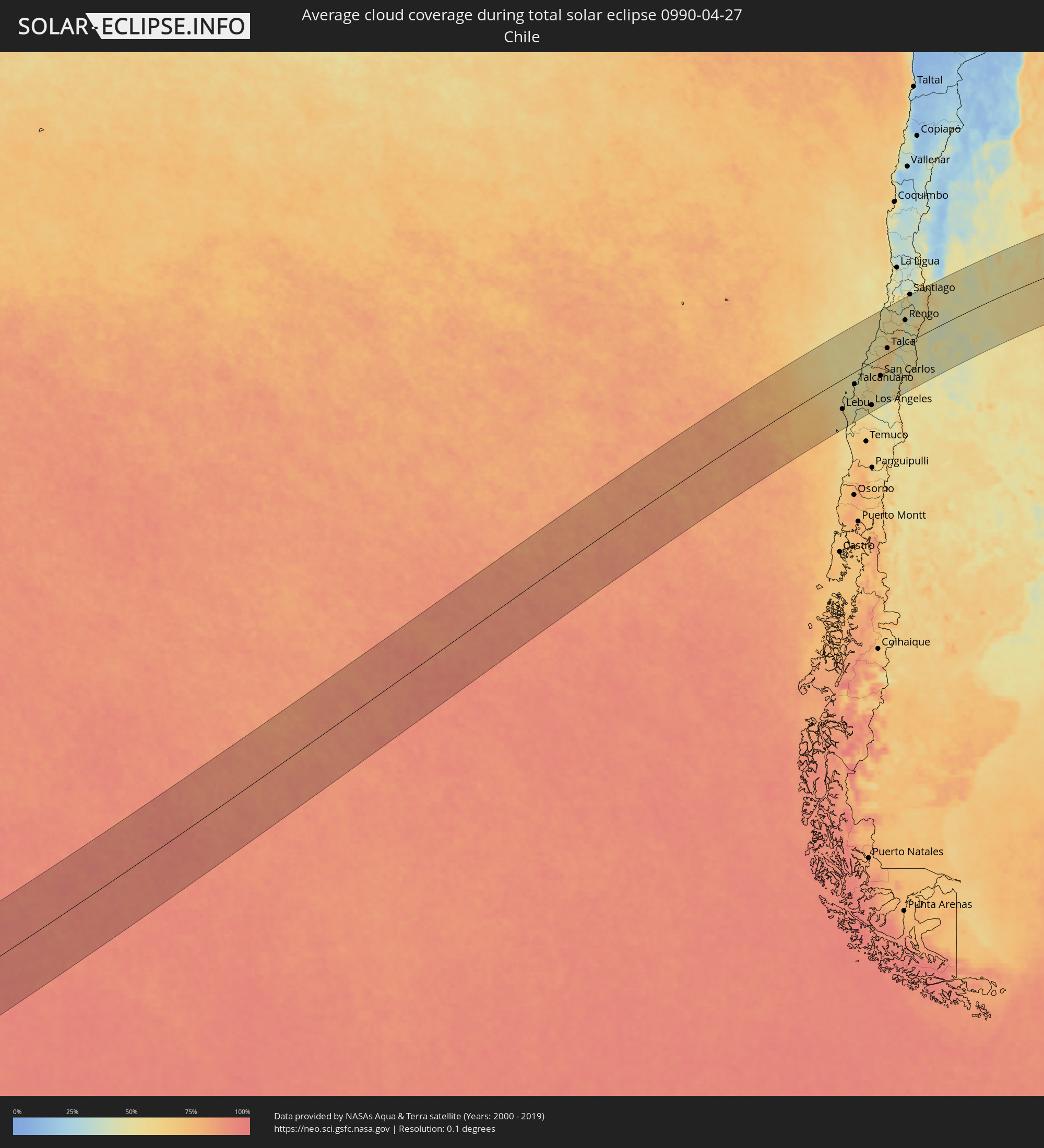 Chile
Chile
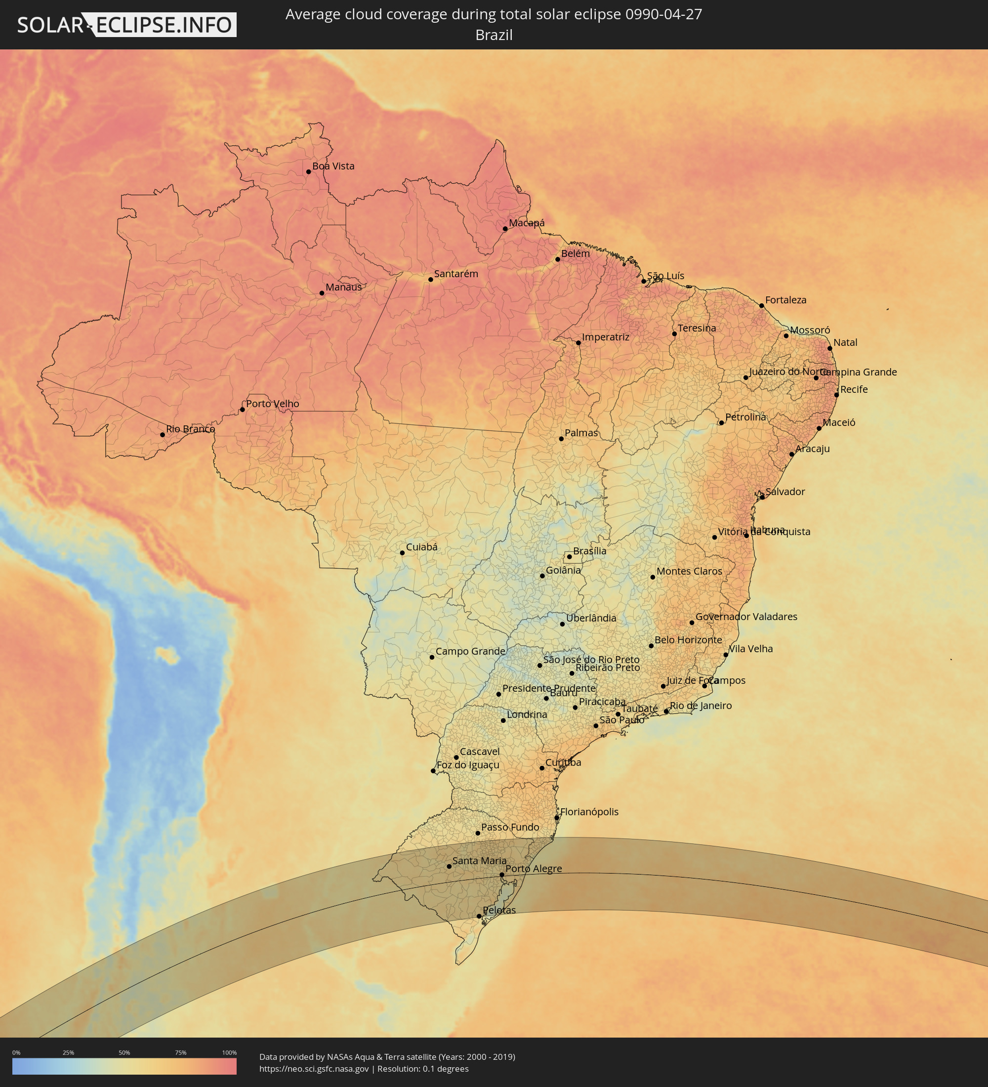 Brazil
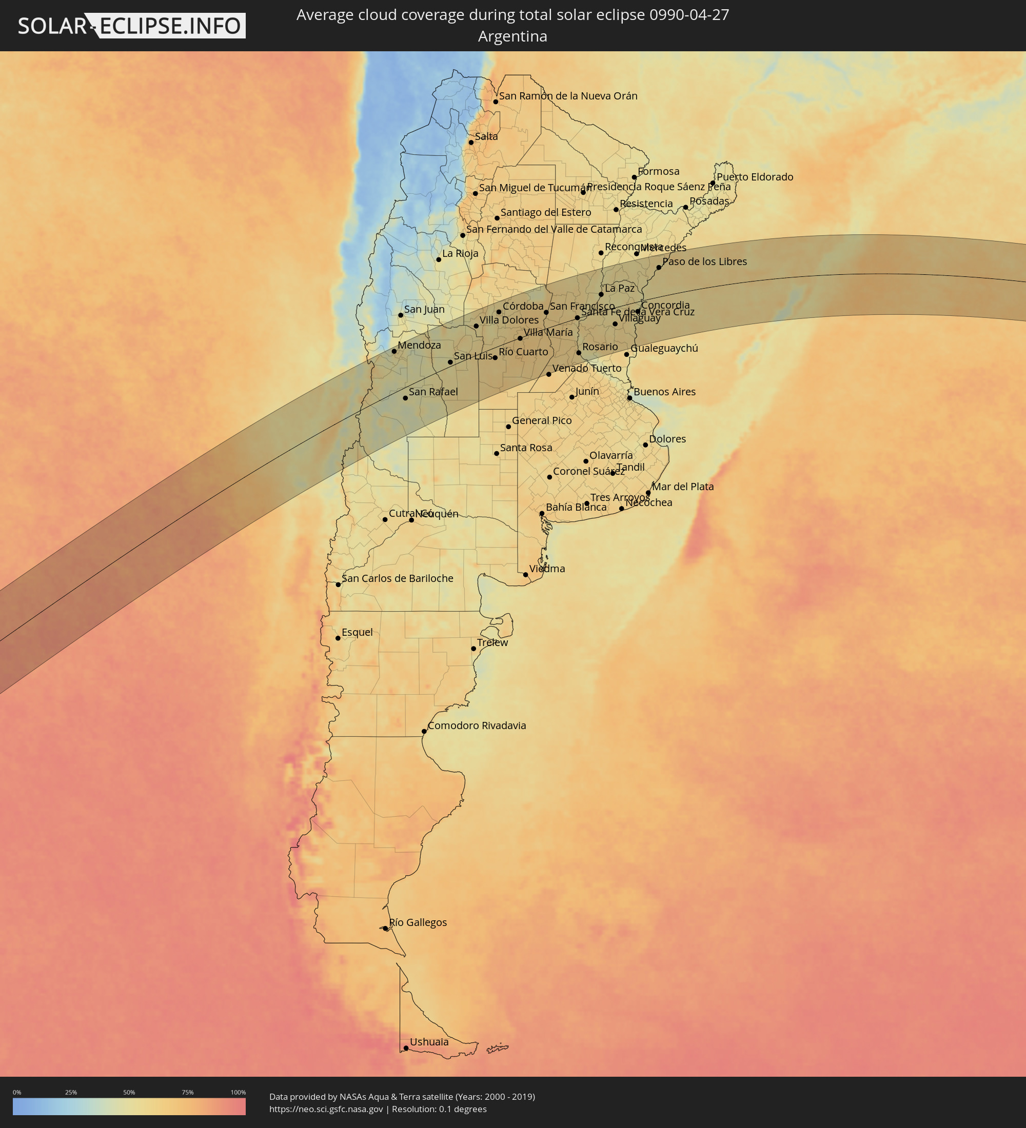 Argentina
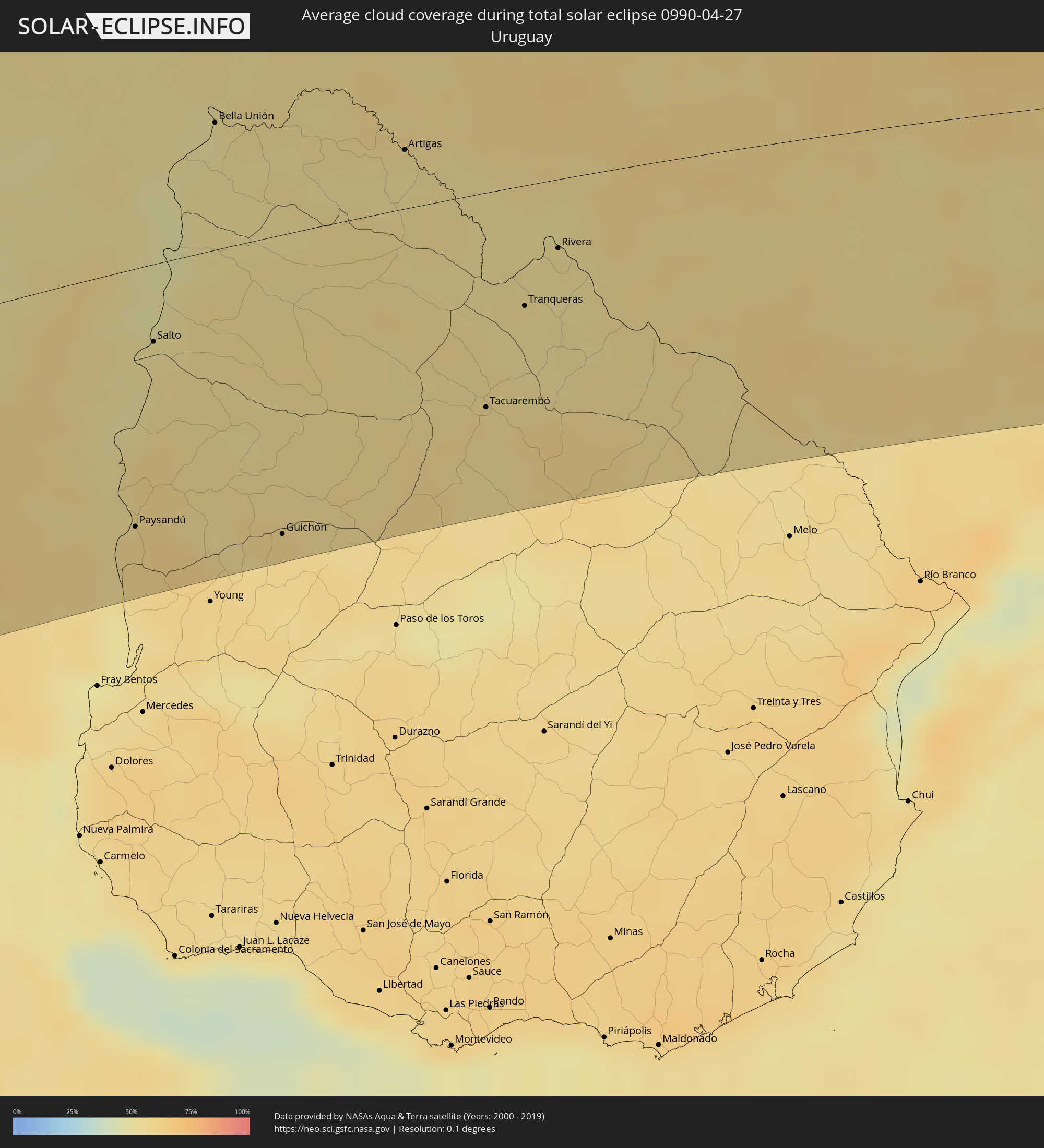 Uruguay
Cities inside the path of the eclipse
The following table shows all locations with a population of more than 5,000 inside the eclipse path. Cities which have more than 100,000 inhabitants are marked bold. A click at the locations opens a detailed map.
| City | Type | Eclipse duration | Local time of max. eclipse | Distance to central line | Ø Cloud coverage |
 Lebu, Biobío
|
total | - | 11:57:27 UTC-04:42 | 102 km | 58% |
|
Cañete, Biobío
|
total | - | 11:57:53 UTC-04:42 | 132 km | 57% |
|
Curanilahue, Biobío
|
total | - | 11:58:08 UTC-04:42 | 104 km | 47% |
|
Arauco, Biobío
|
total | - | 11:58:19 UTC-04:42 | 83 km | 51% |
|
Lota, Biobío
|
total | - | 11:58:43 UTC-04:42 | 75 km | 50% |
|
Coronel, Biobío
|
total | - | 11:58:47 UTC-04:42 | 70 km | 52% |
|
Talcahuano, Biobío
|
total | - | 11:58:59 UTC-04:42 | 42 km | 51% |
|
Concepción, Biobío
|
total | - | 11:59:04 UTC-04:42 | 55 km | 51% |
|
Chiguayante, Biobío
|
total | - | 11:59:04 UTC-04:42 | 65 km | 52% |
|
Penco, Biobío
|
total | - | 11:59:14 UTC-04:42 | 49 km | 50% |
|
Tomé, Biobío
|
total | - | 11:59:22 UTC-04:42 | 39 km | 48% |
|
Angol, Araucanía
|
total | - | 11:59:16 UTC-04:42 | 162 km | 57% |
|
La Laja, Biobío
|
total | - | 11:59:32 UTC-04:42 | 114 km | 51% |
|
Nacimiento, Biobío
|
total | - | 11:59:30 UTC-04:42 | 136 km | 51% |
|
Yumbel, Biobío
|
total | - | 11:59:57 UTC-04:42 | 103 km | 55% |
|
Constitución, Maule
|
total | - | 12:01:13 UTC-04:42 | 61 km | 49% |
|
Cabrero, Biobío
|
total | - | 12:00:18 UTC-04:42 | 104 km | 56% |
|
Los Ángeles, Biobío
|
total | - | 12:00:11 UTC-04:42 | 148 km | 56% |
|
Cauquenes, Maule
|
total | - | 12:01:03 UTC-04:42 | 4 km | 54% |
|
Bulnes, Biobío
|
total | - | 12:00:41 UTC-04:42 | 80 km | 61% |
|
Chillán, Biobío
|
total | - | 12:01:09 UTC-04:42 | 76 km | 59% |
|
San Carlos, Biobío
|
total | - | 12:01:34 UTC-04:42 | 65 km | 61% |
|
Coihueco, Biobío
|
total | - | 12:01:43 UTC-04:42 | 90 km | 49% |
|
Parral, Maule
|
total | - | 12:02:00 UTC-04:42 | 43 km | 63% |
|
San Javier, Maule
|
total | - | 12:02:31 UTC-04:42 | 5 km | 61% |
|
Longaví, Maule
|
total | - | 12:02:24 UTC-04:42 | 32 km | 63% |
|
Talca, Maule
|
total | - | 12:02:47 UTC-04:42 | 19 km | 62% |
|
Linares, Maule
|
total | - | 12:02:40 UTC-04:42 | 25 km | 67% |
|
San Clemente, Maule
|
total | - | 12:03:04 UTC-04:42 | 1 km | 65% |
|
Santa Cruz, O'Higgins
|
total | - | 12:03:53 UTC-04:42 | 83 km | 54% |
|
Rauco, Maule
|
total | - | 12:03:49 UTC-04:42 | 53 km | 62% |
|
Molina, Maule
|
total | - | 12:03:46 UTC-04:42 | 33 km | 61% |
|
Curicó, Maule
|
total | - | 12:03:56 UTC-04:42 | 44 km | 62% |
|
Teno, Maule
|
total | - | 12:04:11 UTC-04:42 | 52 km | 64% |
|
San Vicente, O'Higgins
|
total | - | 12:04:38 UTC-04:42 | 91 km | 54% |
|
San Vicente de Tagua Tagua, O'Higgins
|
total | - | 12:04:38 UTC-04:42 | 90 km | 54% |
|
Chimbarongo, O'Higgins
|
total | - | 12:04:32 UTC-04:42 | 62 km | 62% |
|
El Monte, Santiago Metropolitan
|
total | - | 12:05:20 UTC-04:42 | 161 km | 46% |
|
Talagante, Santiago Metropolitan
|
total | - | 12:05:28 UTC-04:42 | 160 km | 50% |
|
Peñaflor, Santiago Metropolitan
|
total | - | 12:05:37 UTC-04:42 | 164 km | 50% |
|
Rengo, O'Higgins
|
total | - | 12:05:08 UTC-04:42 | 84 km | 54% |
|
Rancagua, O'Higgins
|
total | - | 12:05:32 UTC-04:42 | 103 km | 50% |
|
Buin, Santiago Metropolitan
|
total | - | 12:05:50 UTC-04:42 | 146 km | 49% |
|
Paine, Santiago Metropolitan
|
total | - | 12:05:47 UTC-04:42 | 138 km | 50% |
|
Graneros, O'Higgins
|
total | - | 12:05:38 UTC-04:42 | 112 km | 51% |
|
San Bernardo, Santiago Metropolitan
|
total | - | 12:06:01 UTC-04:42 | 158 km | 50% |
|
Machalí, O'Higgins
|
total | - | 12:05:44 UTC-04:42 | 97 km | 42% |
|
La Pintana, Santiago Metropolitan
|
total | - | 12:06:10 UTC-04:42 | 156 km | 48% |
|
Villa Presidente Frei, Ñuñoa, Santiago, Chile, Santiago Metropolitan
|
total | - | 12:06:22 UTC-04:42 | 166 km | 50% |
|
Puente Alto, Santiago Metropolitan
|
total | - | 12:06:17 UTC-04:42 | 151 km | 48% |
 Mendoza, Mendoza Province
|
total | - | 12:36:39 UTC-04:16 | 151 km | 57% |
|
San Martín, Mendoza Province
|
total | - | 12:37:19 UTC-04:16 | 117 km | 51% |
|
San Rafael, Mendoza Province
|
total | - | 12:36:29 UTC-04:16 | 42 km | 51% |
|
San Luis, San Luis Province
|
total | - | 12:41:55 UTC-04:16 | 13 km | 54% |
|
Villa Mercedes, San Luis Province
|
total | - | 12:43:33 UTC-04:16 | 59 km | 57% |
|
Villa Dolores, Cordoba Province
|
total | - | 12:45:38 UTC-04:16 | 109 km | 55% |
|
Villa Carlos Paz, Cordoba Province
|
total | - | 12:47:40 UTC-04:16 | 139 km | 51% |
|
Cosquín, Cordoba Province
|
total | - | 12:47:54 UTC-04:16 | 157 km | 51% |
|
Alta Gracia, Cordoba Province
|
total | - | 12:47:37 UTC-04:16 | 113 km | 52% |
|
Río Cuarto, Cordoba Province
|
total | - | 12:46:29 UTC-04:16 | 43 km | 61% |
|
La Calera, Cordoba Province
|
total | - | 12:48:07 UTC-04:16 | 142 km | 56% |
|
Río Ceballos, Cordoba Province
|
total | - | 12:48:18 UTC-04:16 | 160 km | 57% |
|
Córdoba, Cordoba Province
|
total | - | 12:48:24 UTC-04:16 | 130 km | 60% |
|
Río Tercero, Cordoba Province
|
total | - | 12:47:52 UTC-04:16 | 48 km | 56% |
|
Jesús María, Cordoba Province
|
total | - | 12:48:59 UTC-04:16 | 172 km | 55% |
|
Río Segundo, Cordoba Province
|
total | - | 12:48:48 UTC-04:16 | 96 km | 58% |
|
Villa María, Cordoba Province
|
total | - | 12:49:37 UTC-04:16 | 5 km | 62% |
|
Arroyito, Cordoba Province
|
total | - | 12:50:58 UTC-04:16 | 92 km | 63% |
|
Bell Ville, Cordoba Province
|
total | - | 12:50:39 UTC-04:16 | 46 km | 64% |
|
Marcos Juárez, Cordoba Province
|
total | - | 12:51:53 UTC-04:16 | 72 km | 64% |
|
San Francisco, Cordoba Province
|
total | - | 12:53:08 UTC-04:16 | 61 km | 61% |
|
San Jorge, Santa Fe Province
|
total | - | 12:53:12 UTC-04:16 | 5 km | 60% |
|
Sunchales, Santa Fe Province
|
total | - | 12:54:47 UTC-04:16 | 97 km | 58% |
|
Rafaela, Santa Fe Province
|
total | - | 12:54:39 UTC-04:16 | 62 km | 59% |
|
Firmat, Santa Fe Province
|
total | - | 12:52:32 UTC-04:16 | 171 km | 62% |
|
Cañada de Gómez, Santa Fe Province
|
total | - | 12:53:20 UTC-04:16 | 106 km | 61% |
|
Gálvez, Santa Fe Province
|
total | - | 12:54:29 UTC-04:16 | 28 km | 61% |
|
Casilda, Santa Fe Province
|
total | - | 12:53:37 UTC-04:16 | 137 km | 60% |
|
Esperanza, Santa Fe Province
|
total | - | 12:55:42 UTC-04:16 | 25 km | 61% |
|
Coronda, Santa Fe Province
|
total | - | 12:55:13 UTC-04:16 | 31 km | 52% |
|
Capitán Bermúdez, Santa Fe Province
|
total | - | 12:54:49 UTC-04:16 | 126 km | 58% |
|
Santa Fe de la Vera Cruz, Santa Fe Province
|
total | - | 12:56:02 UTC-04:16 | 1 km | 57% |
|
Rosario, Santa Fe Province
|
total | - | 12:54:53 UTC-04:16 | 142 km | 54% |
|
Diamante, Entre Ríos Province
|
total | - | 12:55:45 UTC-04:16 | 48 km | 54% |
|
San Justo, Santa Fe Province
|
total | - | 12:57:07 UTC-04:16 | 86 km | 59% |
|
Paraná, Entre Ríos Province
|
total | - | 12:56:20 UTC-04:16 | 16 km | 57% |
|
Arroyo Seco, Santa Fe Province
|
total | - | 12:54:57 UTC-04:16 | 168 km | 60% |
|
Crespo, Entre Ríos Province
|
total | - | 12:56:31 UTC-04:16 | 54 km | 59% |
|
Victoria, Entre Ríos Province
|
total | - | 12:56:16 UTC-04:16 | 121 km | 55% |
|
Santa Elena, Entre Ríos Province
|
total | - | 12:58:45 UTC-04:16 | 48 km | 58% |
|
La Paz, Entre Ríos Province
|
total | - | 12:59:16 UTC-04:16 | 66 km | 52% |
|
Esquina, Corrientes Province
|
total | - | 13:00:17 UTC-04:16 | 142 km | 51% |
|
Villaguay, Entre Ríos Province
|
total | - | 12:59:29 UTC-04:16 | 70 km | 57% |
|
Federal, Entre Ríos Province
|
total | - | 13:00:58 UTC-04:16 | 22 km | 51% |
|
Concepción del Uruguay, Entre Ríos Province
|
total | - | 13:00:34 UTC-04:16 | 155 km | 55% |
 Paysandú, Paysandú
|
total | - | 13:33:02 UTC-03:44 | 142 km | 58% |
|
Curuzú Cuatiá, Corrientes Province
|
total | - | 13:03:47 UTC-04:16 | 132 km | 54% |
|
Concordia, Entre Ríos Province
|
total | - | 13:02:10 UTC-04:16 | 43 km | 52% |
|
Chajarí, Entre Ríos Province
|
total | - | 13:02:56 UTC-04:16 | 26 km | 51% |
|
Salto, Salto
|
total | - | 13:34:15 UTC-03:44 | 43 km | 52% |
|
Monte Caseros, Corrientes Province
|
total | - | 13:04:13 UTC-04:16 | 72 km | 51% |
|
Bella Unión, Artigas
|
total | - | 13:36:14 UTC-03:44 | 71 km | 51% |
|
Guichón, Paysandú
|
total | - | 13:34:52 UTC-03:44 | 165 km | 59% |
 Uruguaiana, Rio Grande do Sul
|
total | - | 14:16:17 UTC-03:06 | 115 km | 57% |
|
Paso de los Libres, Corrientes Province
|
total | - | 13:05:59 UTC-04:16 | 120 km | 56% |
|
Itaqui, Rio Grande do Sul
|
total | - | 14:18:07 UTC-03:06 | 174 km | 57% |
|
Artigas, Artigas
|
total | - | 13:38:32 UTC-03:44 | 33 km | 53% |
|
Quaraí, Rio Grande do Sul
|
total | - | 14:16:58 UTC-03:06 | 34 km | 53% |
|
Tacuarembó, Tacuarembó
|
total | - | 13:38:08 UTC-03:44 | 120 km | 58% |
|
Alegrete, Rio Grande do Sul
|
total | - | 14:19:02 UTC-03:06 | 88 km | 58% |
|
Tranqueras, Rivera
|
total | - | 13:39:11 UTC-03:44 | 68 km | 53% |
|
Rivera, Rivera
|
total | - | 13:39:56 UTC-03:44 | 39 km | 53% |
|
Santana do Livramento, Rio Grande do Sul
|
total | - | 14:18:22 UTC-03:06 | 38 km | 55% |
|
Rosário do Sul, Rio Grande do Sul
|
total | - | 14:20:22 UTC-03:06 | 22 km | 61% |
|
Santiago, Rio Grande do Sul
|
total | - | 14:21:39 UTC-03:06 | 138 km | 53% |
|
Dom Pedrito, Rio Grande do Sul
|
total | - | 14:20:04 UTC-03:06 | 62 km | 55% |
|
São Gabriel, Rio Grande do Sul
|
total | - | 14:21:31 UTC-03:06 | 4 km | 60% |
|
Bagé, Rio Grande do Sul
|
total | - | 14:20:50 UTC-03:06 | 108 km | 61% |
|
Santa Maria, Rio Grande do Sul
|
total | - | 14:23:19 UTC-03:06 | 69 km | 62% |
|
Júlio de Castilhos, Rio Grande do Sul
|
total | - | 14:24:05 UTC-03:06 | 118 km | 62% |
|
Cachoeira do Sul, Rio Grande do Sul
|
total | - | 14:24:47 UTC-03:06 | 19 km | 61% |
|
Candelária, Rio Grande do Sul
|
total | - | 14:25:25 UTC-03:06 | 59 km | 61% |
|
Soledade, Rio Grande do Sul
|
total | - | 14:26:57 UTC-03:06 | 150 km | 63% |
|
Santa Cruz do Sul, Rio Grande do Sul
|
total | - | 14:26:05 UTC-03:06 | 49 km | 60% |
|
Rio Pardo, Rio Grande do Sul
|
total | - | 14:25:52 UTC-03:06 | 19 km | 58% |
|
Venâncio Aires, Rio Grande do Sul
|
total | - | 14:26:41 UTC-03:06 | 59 km | 60% |
|
São Lourenço do Sul, Rio Grande do Sul
|
total | - | 14:25:05 UTC-03:06 | 138 km | 51% |
|
Lajeado, Rio Grande do Sul
|
total | - | 14:27:18 UTC-03:06 | 73 km | 56% |
|
Taquari, Rio Grande do Sul
|
total | - | 14:27:07 UTC-03:06 | 35 km | 55% |
|
Camaquã, Rio Grande do Sul
|
total | - | 14:26:00 UTC-03:06 | 82 km | 64% |
|
Teutônia, Rio Grande do Sul
|
total | - | 14:27:38 UTC-03:06 | 73 km | 58% |
|
Charqueadas, Rio Grande do Sul
|
total | - | 14:27:24 UTC-03:06 | 15 km | 59% |
|
Garibaldi, Rio Grande do Sul
|
total | - | 14:28:24 UTC-03:06 | 92 km | 61% |
|
Bento Gonçalves, Rio Grande do Sul
|
total | - | 14:28:31 UTC-03:06 | 101 km | 61% |
|
Montenegro, Rio Grande do Sul
|
total | - | 14:28:02 UTC-03:06 | 44 km | 58% |
|
Farroupilha, Rio Grande do Sul
|
total | - | 14:28:48 UTC-03:06 | 94 km | 60% |
|
Portão, Rio Grande do Sul
|
total | - | 14:28:27 UTC-03:06 | 40 km | 61% |
|
Porto Alegre, Rio Grande do Sul
|
total | - | 14:28:06 UTC-03:06 | 4 km | 59% |
|
Flores da Cunha, Rio Grande do Sul
|
total | - | 14:29:21 UTC-03:06 | 115 km | 60% |
|
Caxias do Sul, Rio Grande do Sul
|
total | - | 14:29:12 UTC-03:06 | 99 km | 58% |
|
Sapucaia, Rio Grande do Sul
|
total | - | 14:28:29 UTC-03:06 | 25 km | 64% |
|
Novo Hamburgo, Rio Grande do Sul
|
total | - | 14:28:42 UTC-03:06 | 42 km | 61% |
|
Viamão, Rio Grande do Sul
|
total | - | 14:28:26 UTC-03:06 | 3 km | 58% |
|
Gravataí, Rio Grande do Sul
|
total | - | 14:28:40 UTC-03:06 | 12 km | 62% |
|
Vacaria, Rio Grande do Sul
|
total | - | 14:30:26 UTC-03:06 | 170 km | 64% |
|
Parobé, Rio Grande do Sul
|
total | - | 14:29:20 UTC-03:06 | 45 km | 59% |
|
Canela, Rio Grande do Sul
|
total | - | 14:29:42 UTC-03:06 | 76 km | 58% |
|
Igrejinha, Rio Grande do Sul
|
total | - | 14:29:29 UTC-03:06 | 51 km | 59% |
|
Três Coroas, Rio Grande do Sul
|
total | - | 14:29:35 UTC-03:06 | 57 km | 58% |
|
Osório, Rio Grande do Sul
|
total | - | 14:30:07 UTC-03:06 | 13 km | 56% |
|
Tramandaí, Rio Grande do Sul
|
total | - | 14:30:16 UTC-03:06 | 2 km | 54% |
|
Capão da Canoa, Rio Grande do Sul
|
total | - | 14:30:47 UTC-03:06 | 27 km | 54% |
|
Torres, Rio Grande do Sul
|
total | - | 14:31:48 UTC-03:06 | 72 km | 49% |
|
Araranguá, Santa Catarina
|
total | - | 14:32:43 UTC-03:06 | 115 km | 57% |
|
Forquilhinha, Santa Catarina
|
total | - | 14:32:59 UTC-03:06 | 136 km | 61% |
|
Criciúma, Santa Catarina
|
total | - | 14:33:15 UTC-03:06 | 143 km | 59% |
|
Tubarão, Santa Catarina
|
total | - | 14:34:11 UTC-03:06 | 165 km | 57% |
|
Laguna, Santa Catarina
|
total | - | 14:34:35 UTC-03:06 | 163 km | 51% |