Total solar eclipse of 12/24/1014
| Day of week: | Saturday |
| Maximum duration of eclipse: | 02m25s |
| Maximum width of eclipse path: | 95 km |
| Saros cycle: | 106 |
| Coverage: | 100% |
| Magnitude: | 1.0272 |
| Gamma: | -0.2153 |
Wo kann man die Sonnenfinsternis vom 12/24/1014 sehen?
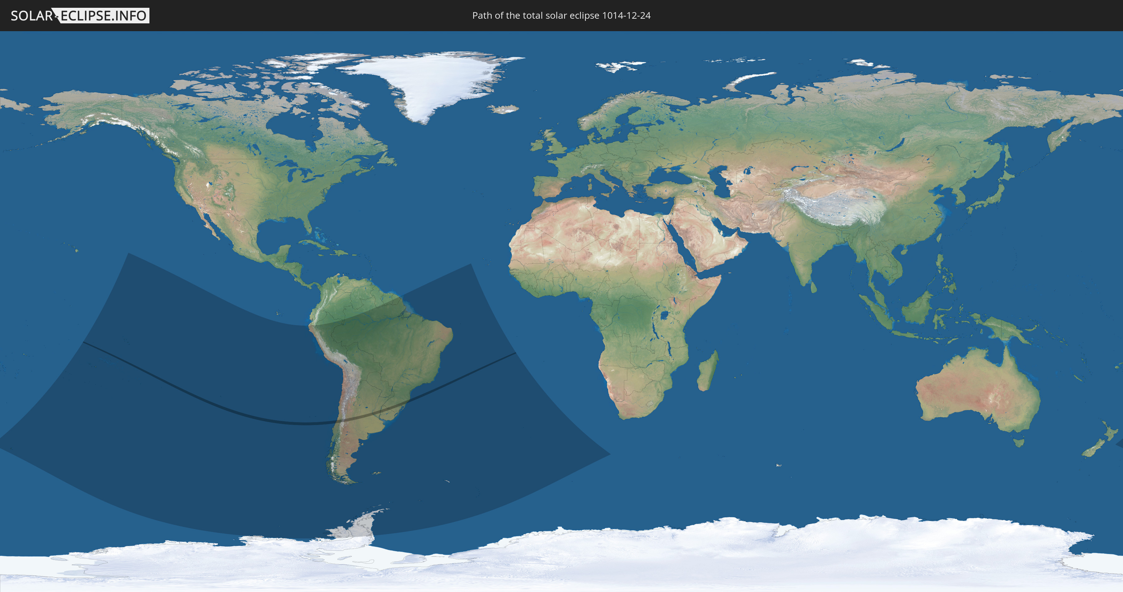
Die Sonnenfinsternis am 12/24/1014 kann man in 21 Ländern als partielle Sonnenfinsternis beobachten.
Der Finsternispfad verläuft durch 5 Länder. Nur in diesen Ländern ist sie als total Sonnenfinsternis zu sehen.
In den folgenden Ländern ist die Sonnenfinsternis total zu sehen
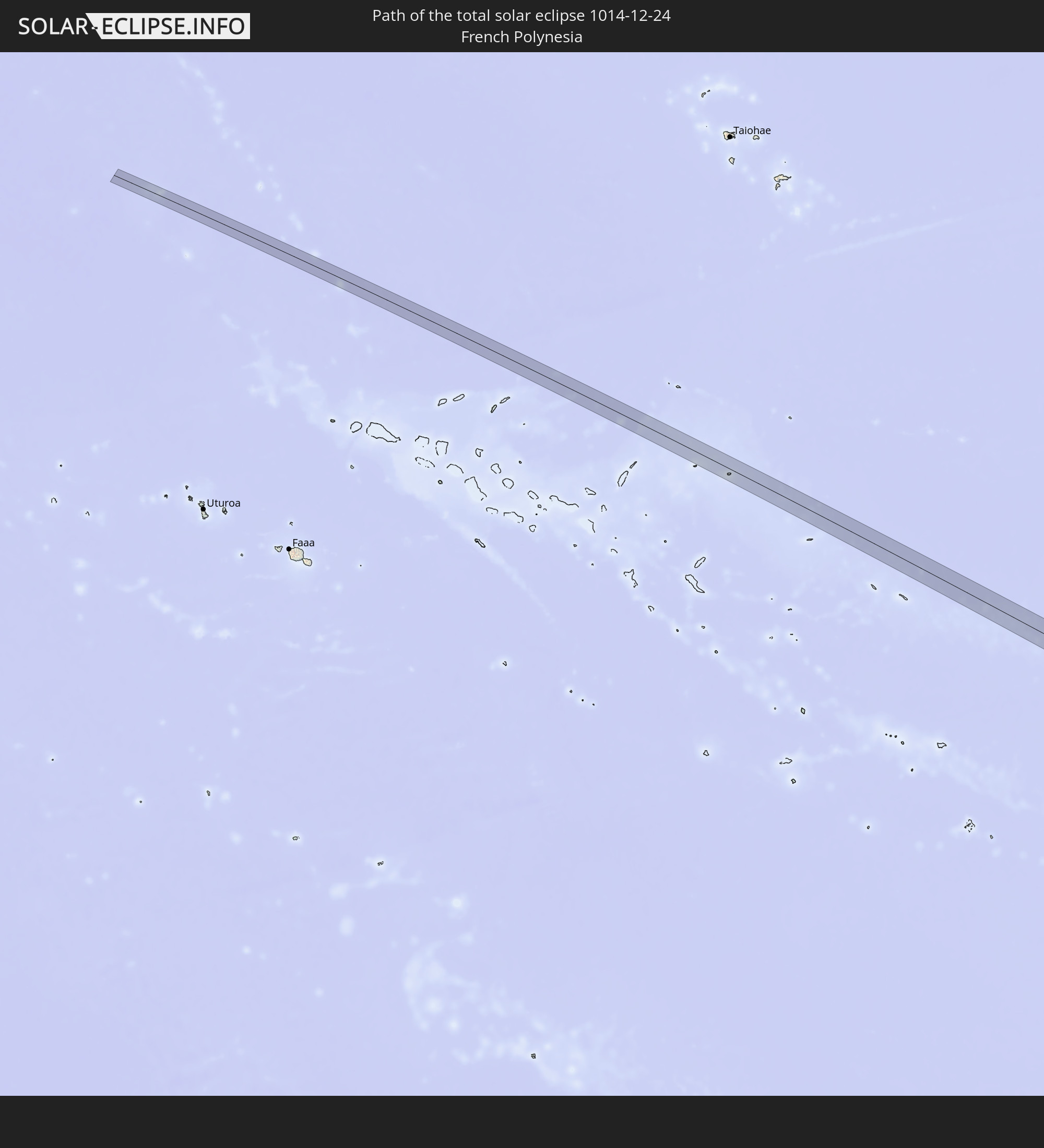 French Polynesia
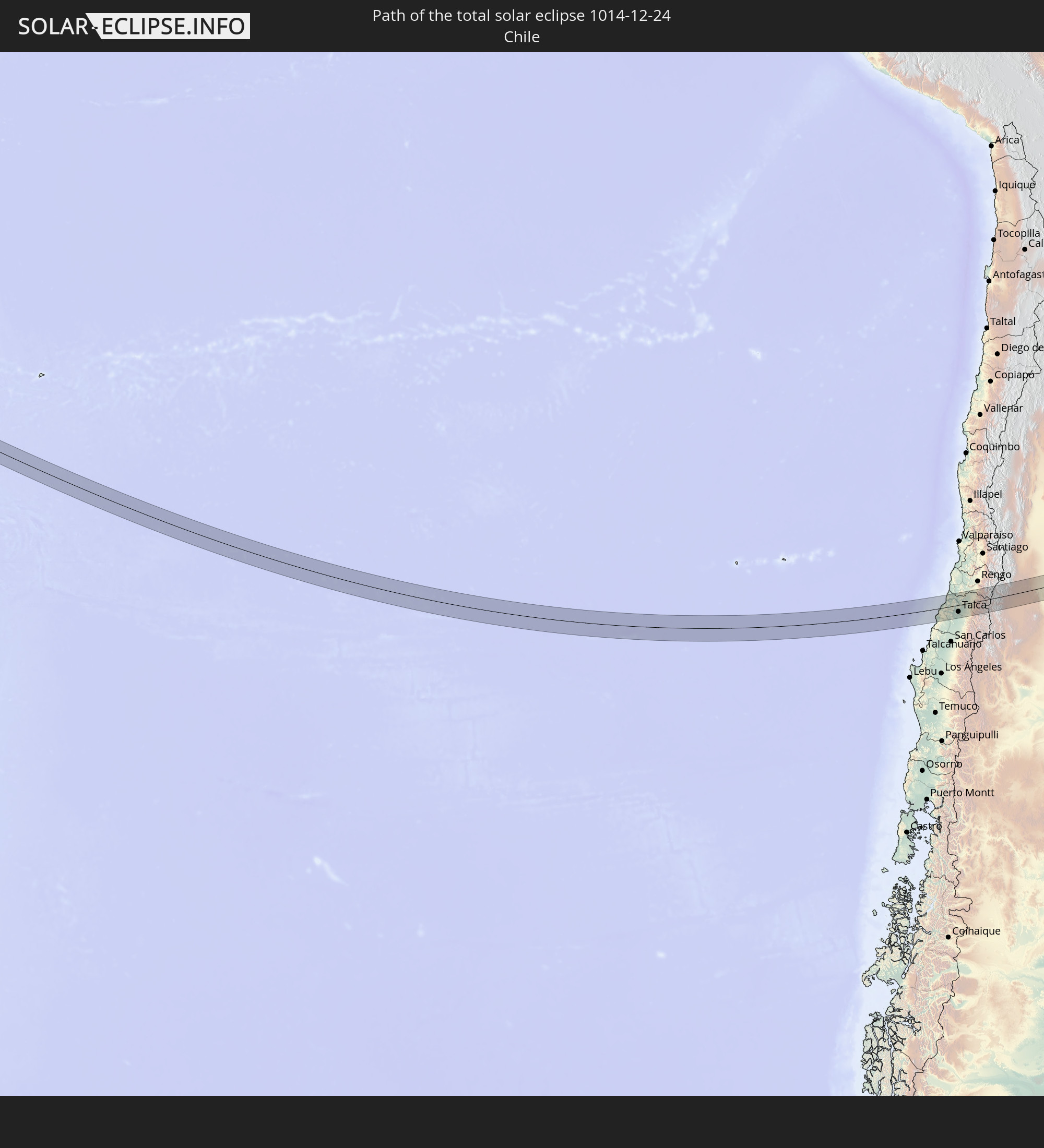 Chile
Chile
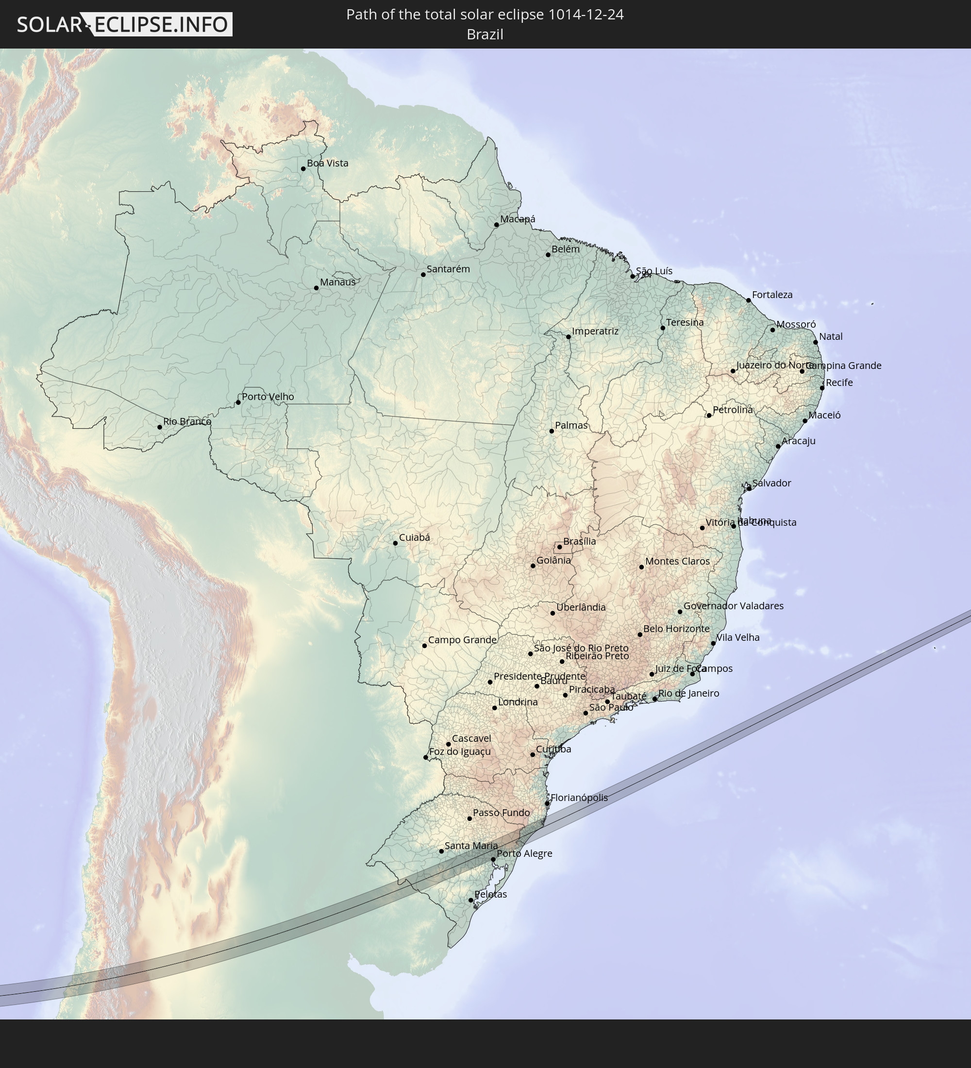 Brazil
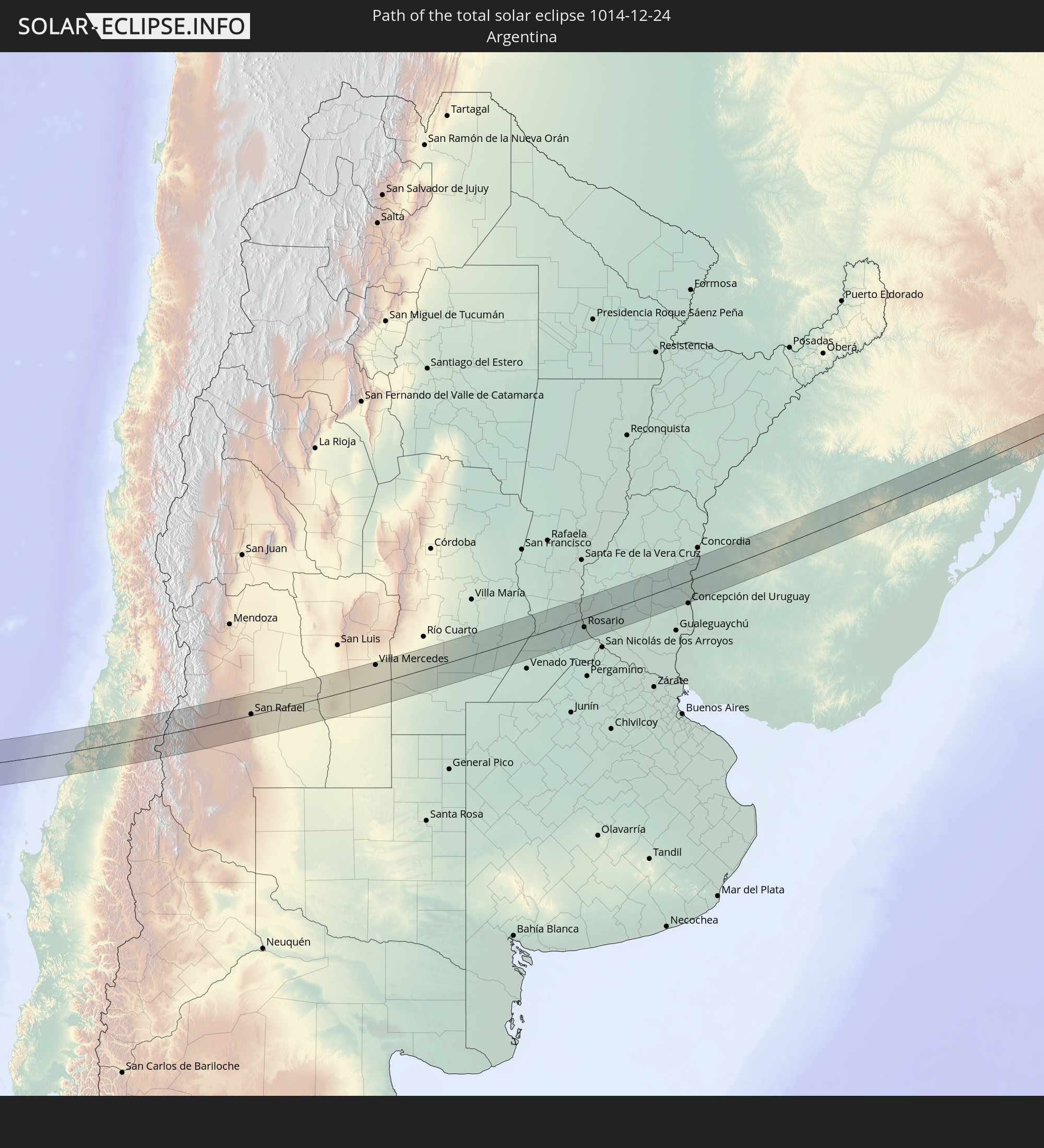 Argentina
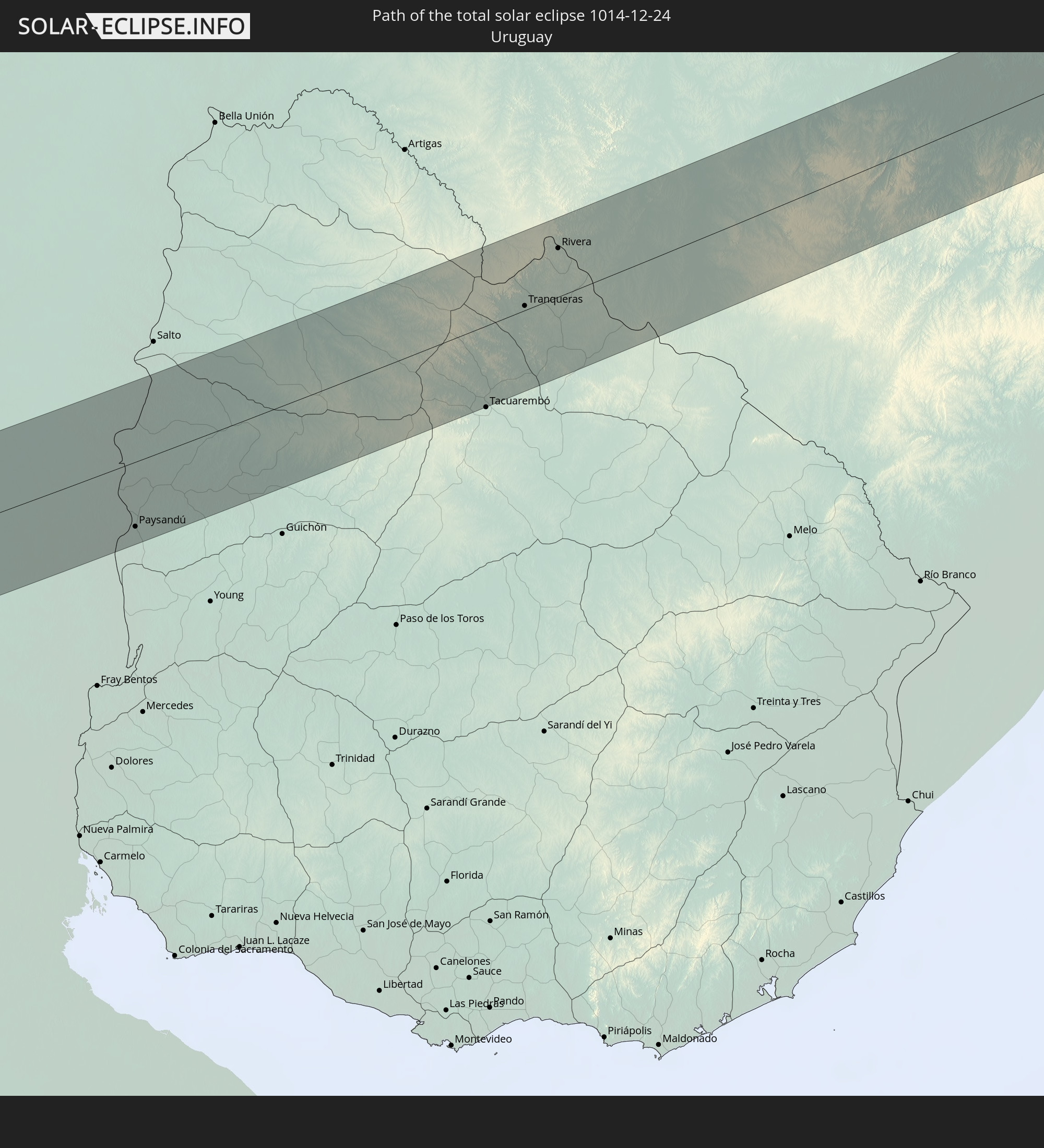 Uruguay
In den folgenden Ländern ist die Sonnenfinsternis partiell zu sehen


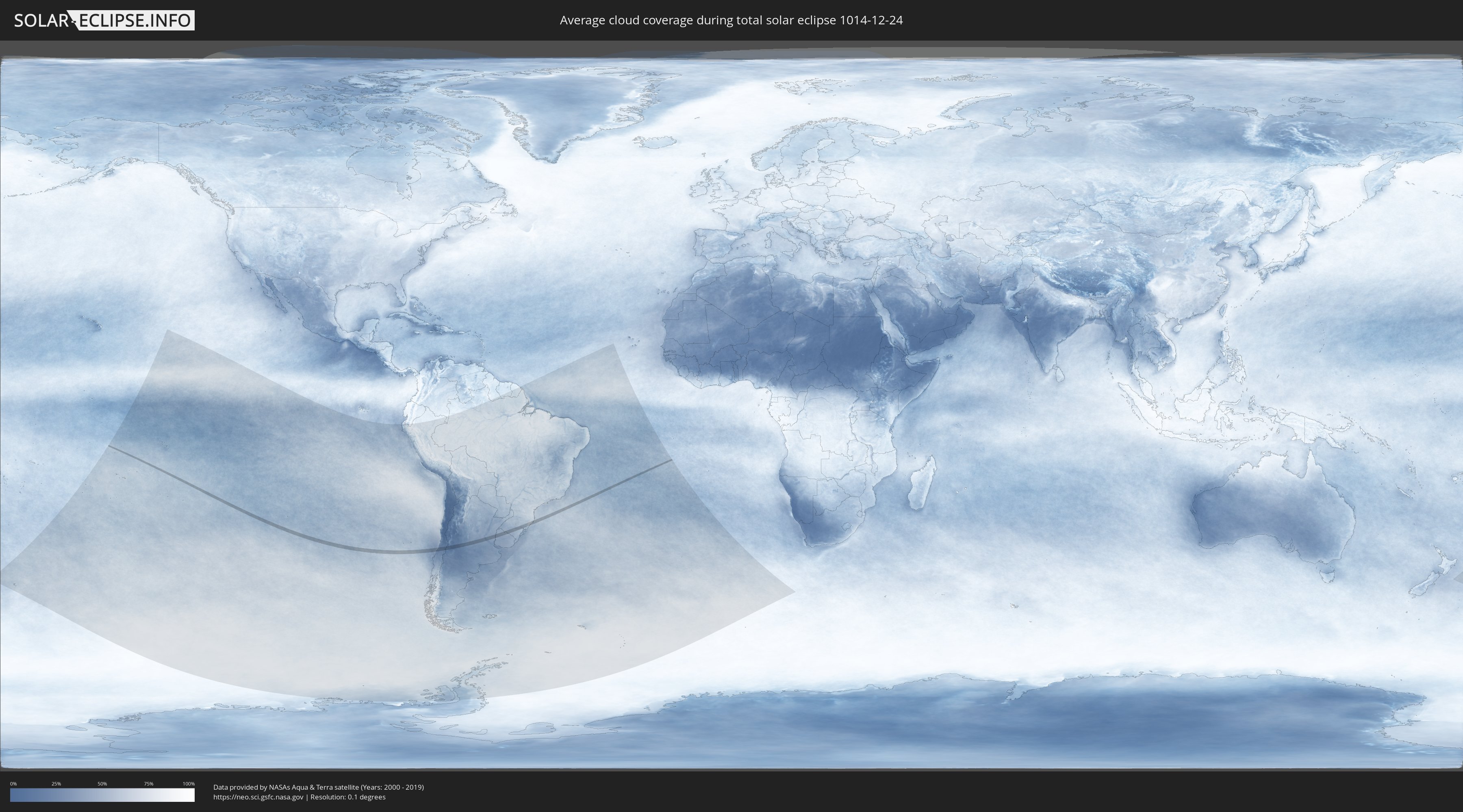
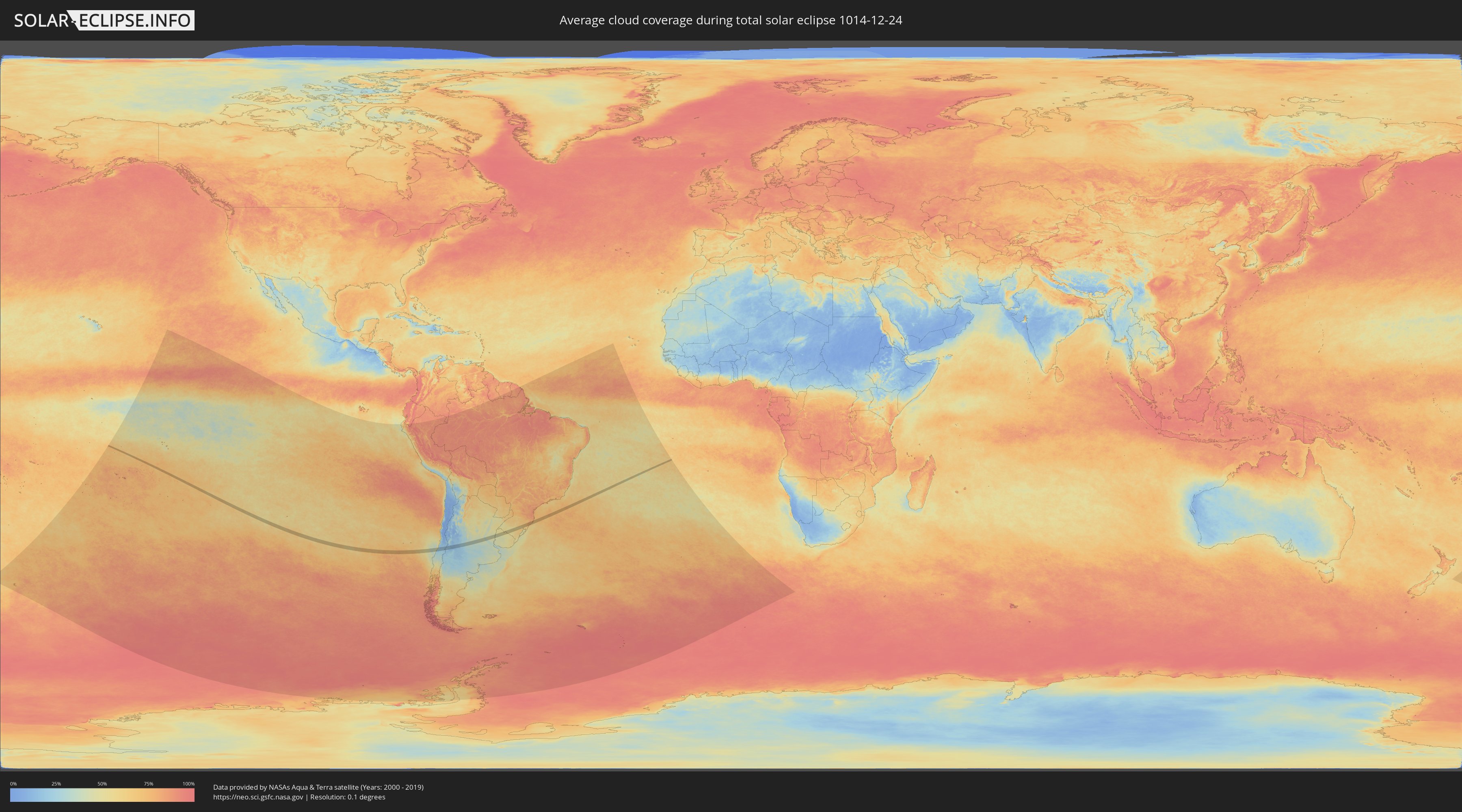
How will be the weather during the total solar eclipse on 12/24/1014?
Where is the best place to see the total solar eclipse of 12/24/1014?
The following maps show the average cloud coverage for the day of the total solar eclipse.
With the help of these maps, it is possible to find the place along the eclipse path, which has the best
chance of a cloudless sky.
Nevertheless, you should consider local circumstances and inform about the weather of your chosen
observation site.
The data is provided by NASAs satellites
AQUA and TERRA.
The cloud maps are averaged over a period of 19 years (2000 - 2019).
Detailed country maps
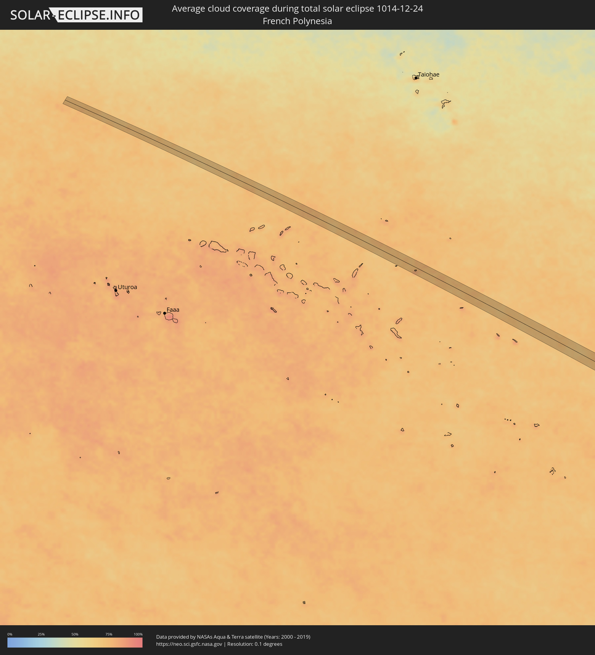 French Polynesia
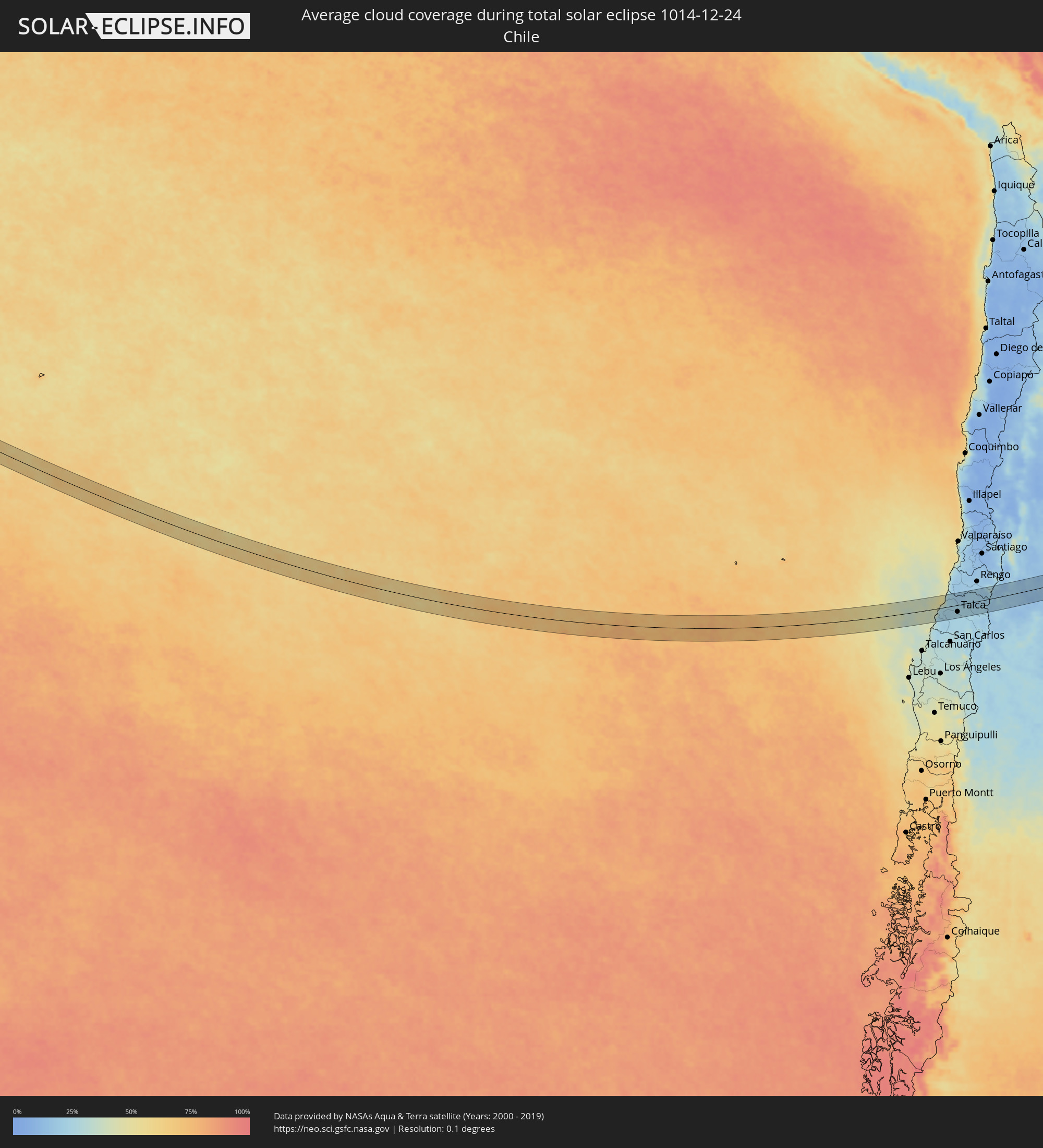 Chile
Chile
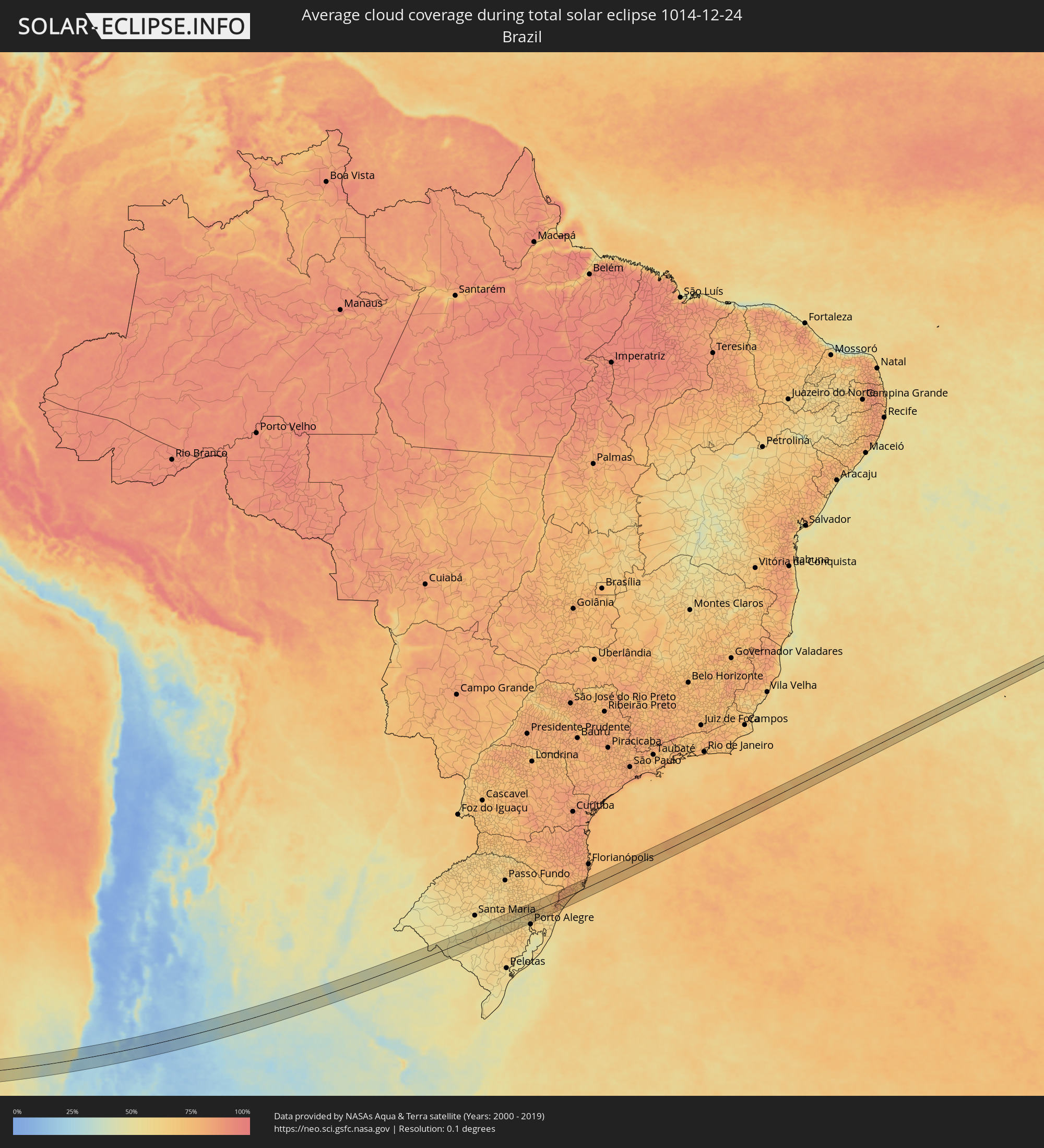 Brazil
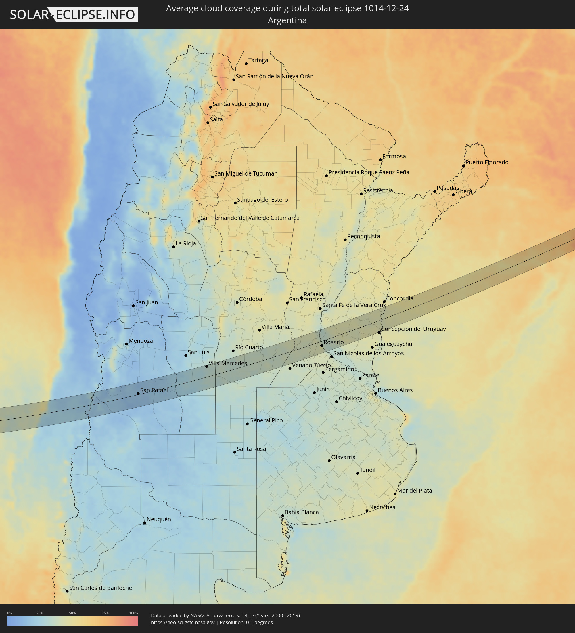 Argentina
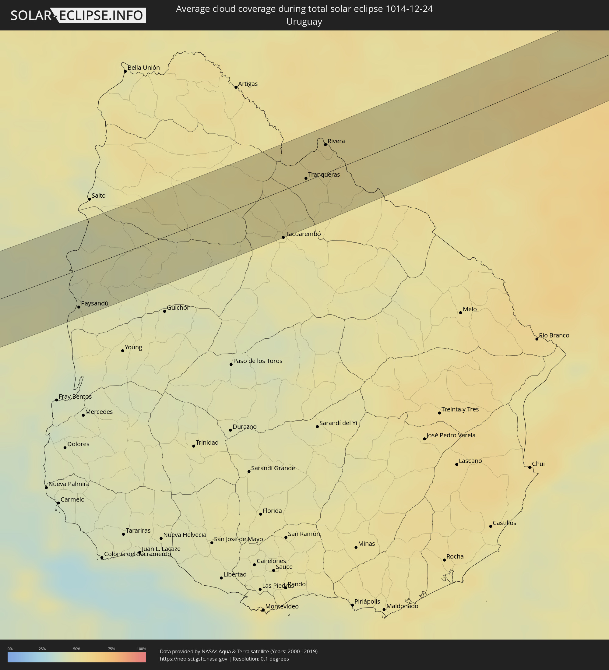 Uruguay
Cities inside the path of the eclipse
The following table shows all locations with a population of more than 5,000 inside the eclipse path. Cities which have more than 100,000 inhabitants are marked bold. A click at the locations opens a detailed map.
| City | Type | Eclipse duration | Local time of max. eclipse | Distance to central line | Ø Cloud coverage |
 Constitución, Maule
|
total | - | 13:31:10 UTC-04:42 | 2 km | 29% |
|
San Javier, Maule
|
total | - | 13:32:28 UTC-04:42 | 42 km | 24% |
|
Talca, Maule
|
total | - | 13:32:44 UTC-04:42 | 24 km | 24% |
|
San Clemente, Maule
|
total | - | 13:33:01 UTC-04:42 | 39 km | 25% |
|
Rauco, Maule
|
total | - | 13:33:48 UTC-04:42 | 25 km | 21% |
|
Molina, Maule
|
total | - | 13:33:45 UTC-04:42 | 4 km | 22% |
|
Curicó, Maule
|
total | - | 13:33:56 UTC-04:42 | 17 km | 20% |
|
Teno, Maule
|
total | - | 13:34:10 UTC-04:42 | 28 km | 22% |
|
Chimbarongo, O'Higgins
|
total | - | 13:34:32 UTC-04:42 | 44 km | 22% |
 San Rafael, Mendoza Province
|
total | - | 14:06:14 UTC-04:16 | 2 km | 16% |
|
Villa Mercedes, San Luis Province
|
total | - | 14:12:44 UTC-04:16 | 38 km | 31% |
|
Justo Daract, San Luis Province
|
total | - | 14:13:05 UTC-04:16 | 11 km | 35% |
|
Coronel Moldes, Cordoba Province
|
total | - | 14:14:25 UTC-04:16 | 22 km | 33% |
|
Vicuña Mackenna, Cordoba Province
|
total | - | 14:14:31 UTC-04:16 | 15 km | 34% |
|
Adelia María, Cordoba Province
|
total | - | 14:15:29 UTC-04:16 | 6 km | 36% |
|
General Levalle, Cordoba Province
|
total | - | 14:15:17 UTC-04:16 | 38 km | 34% |
|
La Carlota, Cordoba Province
|
total | - | 14:17:01 UTC-04:16 | 9 km | 38% |
|
Canals, Cordoba Province
|
total | - | 14:17:37 UTC-04:16 | 18 km | 38% |
|
Laborde, Cordoba Province
|
total | - | 14:18:05 UTC-04:16 | 25 km | 36% |
|
Monte Maíz, Cordoba Province
|
total | - | 14:18:30 UTC-04:16 | 12 km | 36% |
|
Monte Buey, Cordoba Province
|
total | - | 14:19:03 UTC-04:16 | 39 km | 36% |
|
Arias, Cordoba Province
|
total | - | 14:18:24 UTC-04:16 | 40 km | 37% |
|
Corral de Bustos, Cordoba Province
|
total | - | 14:19:09 UTC-04:16 | 8 km | 39% |
|
Chañar Ladeado, Santa Fe Province
|
total | - | 14:19:22 UTC-04:16 | 17 km | 38% |
|
Cruz Alta, Cordoba Province
|
total | - | 14:20:06 UTC-04:16 | 10 km | 41% |
|
Armstrong, Santa Fe Province
|
total | - | 14:20:42 UTC-04:16 | 28 km | 41% |
|
Las Parejas, Santa Fe Province
|
total | - | 14:20:57 UTC-04:16 | 36 km | 40% |
|
Cañada de Gómez, Santa Fe Province
|
total | - | 14:21:01 UTC-04:16 | 18 km | 40% |
|
Totoras, Santa Fe Province
|
total | - | 14:21:40 UTC-04:16 | 36 km | 41% |
|
Casilda, Santa Fe Province
|
total | - | 14:21:10 UTC-04:16 | 12 km | 41% |
|
Carcarañá, Santa Fe Province
|
total | - | 14:21:24 UTC-04:16 | 7 km | 40% |
|
Roldán, Santa Fe Province
|
total | - | 14:21:46 UTC-04:16 | 5 km | 42% |
|
Funes, Santa Fe Province
|
total | - | 14:21:55 UTC-04:16 | 10 km | 42% |
|
Pérez, Santa Fe Province
|
total | - | 14:21:54 UTC-04:16 | 20 km | 42% |
|
Fray Luis A. Beltrán, Santa Fe Province
|
total | - | 14:22:11 UTC-04:16 | 1 km | 41% |
|
Capitán Bermúdez, Santa Fe Province
|
total | - | 14:22:10 UTC-04:16 | 3 km | 41% |
|
Granadero Baigorria, Santa Fe Province
|
total | - | 14:22:08 UTC-04:16 | 6 km | 48% |
|
Gobernador Gálvez, Santa Fe Province
|
total | - | 14:22:05 UTC-04:16 | 27 km | 41% |
|
Rosario, Santa Fe Province
|
total | - | 14:22:10 UTC-04:16 | 18 km | 40% |
|
Arroyo Seco, Santa Fe Province
|
total | - | 14:22:10 UTC-04:16 | 44 km | 41% |
|
Victoria, Entre Ríos Province
|
total | - | 14:23:21 UTC-04:16 | 2 km | 39% |
|
Maciá, Entre Ríos Province
|
total | - | 14:25:05 UTC-04:16 | 25 km | 44% |
|
Rosario del Tala, Entre Ríos Province
|
total | - | 14:25:21 UTC-04:16 | 3 km | 43% |
|
Villa Elisa, Entre Ríos Province
|
total | - | 14:26:42 UTC-04:16 | 7 km | 45% |
 Paysandú, Paysandú
|
total | - | 14:58:59 UTC-03:44 | 34 km | 44% |
|
Tranqueras, Rivera
|
total | - | 15:03:46 UTC-03:44 | 2 km | 51% |
|
Rivera, Rivera
|
total | - | 15:04:24 UTC-03:44 | 26 km | 54% |
 Santana do Livramento, Rio Grande do Sul
|
total | - | 15:42:50 UTC-03:06 | 26 km | 52% |
|
Dom Pedrito, Rio Grande do Sul
|
total | - | 15:43:56 UTC-03:06 | 14 km | 49% |
|
São Gabriel, Rio Grande do Sul
|
total | - | 15:45:11 UTC-03:06 | 39 km | 53% |
|
São Sepé, Rio Grande do Sul
|
total | - | 15:46:25 UTC-03:06 | 29 km | 58% |
|
Caçapava do Sul, Rio Grande do Sul
|
total | - | 15:46:06 UTC-03:06 | 10 km | 58% |
|
Cachoeira do Sul, Rio Grande do Sul
|
total | - | 15:47:27 UTC-03:06 | 16 km | 52% |
|
Santa Cruz do Sul, Rio Grande do Sul
|
total | - | 15:48:26 UTC-03:06 | 31 km | 61% |
|
Rio Pardo, Rio Grande do Sul
|
total | - | 15:48:10 UTC-03:06 | 2 km | 56% |
|
Venâncio Aires, Rio Grande do Sul
|
total | - | 15:48:52 UTC-03:06 | 34 km | 60% |
|
Butiá, Rio Grande do Sul
|
total | - | 15:48:33 UTC-03:06 | 28 km | 62% |
|
Lajeado, Rio Grande do Sul
|
total | - | 15:49:19 UTC-03:06 | 39 km | 61% |
|
Taquari, Rio Grande do Sul
|
total | - | 15:49:03 UTC-03:06 | 1 km | 56% |
|
Teutônia, Rio Grande do Sul
|
total | - | 15:49:32 UTC-03:06 | 35 km | 63% |
|
Arroio dos Ratos, Rio Grande do Sul
|
total | - | 15:48:53 UTC-03:06 | 32 km | 65% |
|
São Jerônimo, Rio Grande do Sul
|
total | - | 15:49:02 UTC-03:06 | 20 km | 61% |
|
Triunfo, Rio Grande do Sul
|
total | - | 15:49:04 UTC-03:06 | 19 km | 57% |
|
Charqueadas, Rio Grande do Sul
|
total | - | 15:49:10 UTC-03:06 | 24 km | 60% |
|
Carlos Barbosa, Rio Grande do Sul
|
total | - | 15:50:06 UTC-03:06 | 38 km | 66% |
|
Montenegro, Rio Grande do Sul
|
total | - | 15:49:41 UTC-03:06 | 3 km | 62% |
|
São Sebastião do Caí, Rio Grande do Sul
|
total | - | 15:49:54 UTC-03:06 | 4 km | 62% |
|
Farroupilha, Rio Grande do Sul
|
total | - | 15:50:22 UTC-03:06 | 40 km | 67% |
|
Portão, Rio Grande do Sul
|
total | - | 15:49:56 UTC-03:06 | 13 km | 65% |
|
Canoas, Rio Grande do Sul
|
total | - | 15:49:45 UTC-03:06 | 37 km | 64% |
|
Caxias do Sul, Rio Grande do Sul
|
total | - | 15:50:39 UTC-03:06 | 39 km | 68% |
|
Esteio, Rio Grande do Sul
|
total | - | 15:49:49 UTC-03:06 | 32 km | 64% |
|
Estância Velha, Rio Grande do Sul
|
total | - | 15:50:05 UTC-03:06 | 10 km | 62% |
|
Ivoti, Rio Grande do Sul
|
total | - | 15:50:10 UTC-03:06 | 5 km | 62% |
|
Sapucaia, Rio Grande do Sul
|
total | - | 15:49:53 UTC-03:06 | 30 km | 66% |
|
Novo Hamburgo, Rio Grande do Sul
|
total | - | 15:50:06 UTC-03:06 | 15 km | 63% |
|
Nova Petrópolis, Rio Grande do Sul
|
total | - | 15:50:29 UTC-03:06 | 15 km | 64% |
|
Sapiranga, Rio Grande do Sul
|
total | - | 15:50:18 UTC-03:06 | 16 km | 62% |
|
Parobé, Rio Grande do Sul
|
total | - | 15:50:31 UTC-03:06 | 22 km | 62% |
|
Canela, Rio Grande do Sul
|
total | - | 15:50:52 UTC-03:06 | 5 km | 66% |
|
Igrejinha, Rio Grande do Sul
|
total | - | 15:50:38 UTC-03:06 | 18 km | 62% |
|
Taquara, Rio Grande do Sul
|
total | - | 15:50:33 UTC-03:06 | 26 km | 61% |
|
Três Coroas, Rio Grande do Sul
|
total | - | 15:50:43 UTC-03:06 | 13 km | 64% |
|
São Francisco de Paula, Rio Grande do Sul
|
total | - | 15:51:02 UTC-03:06 | 13 km | 68% |
|
Rolante, Rio Grande do Sul
|
total | - | 15:50:48 UTC-03:06 | 34 km | 60% |
|
Torres, Rio Grande do Sul
|
total | - | 15:52:09 UTC-03:06 | 36 km | 66% |
|
Sombrio, Santa Catarina
|
total | - | 15:52:33 UTC-03:06 | 18 km | 68% |
|
Araranguá, Santa Catarina
|
total | - | 15:52:54 UTC-03:06 | 5 km | 73% |
|
Forquilhinha, Santa Catarina
|
total | - | 15:53:09 UTC-03:06 | 13 km | 78% |
|
Criciúma, Santa Catarina
|
total | - | 15:53:21 UTC-03:06 | 16 km | 77% |
|
Cocal, Santa Catarina
|
total | - | 15:53:29 UTC-03:06 | 22 km | 79% |
|
Içara, Santa Catarina
|
total | - | 15:53:23 UTC-03:06 | 10 km | 75% |
|
Morro da Fumaça, Santa Catarina
|
total | - | 15:53:33 UTC-03:06 | 12 km | 73% |
|
Jaguaruna, Santa Catarina
|
total | - | 15:53:48 UTC-03:06 | 8 km | 72% |
|
Tubarão, Santa Catarina
|
total | - | 15:54:00 UTC-03:06 | 23 km | 72% |
|
Laguna, Santa Catarina
|
total | - | 15:54:14 UTC-03:06 | 12 km | 68% |
|
Imbituba, Santa Catarina
|
total | - | 15:54:38 UTC-03:06 | 32 km | 73% |