Total solar eclipse of 05/20/1053
| Day of week: | Friday |
| Maximum duration of eclipse: | 05m55s |
| Maximum width of eclipse path: | 336 km |
| Saros cycle: | 93 |
| Coverage: | 100% |
| Magnitude: | 1.069 |
| Gamma: | -0.7481 |
Wo kann man die Sonnenfinsternis vom 05/20/1053 sehen?
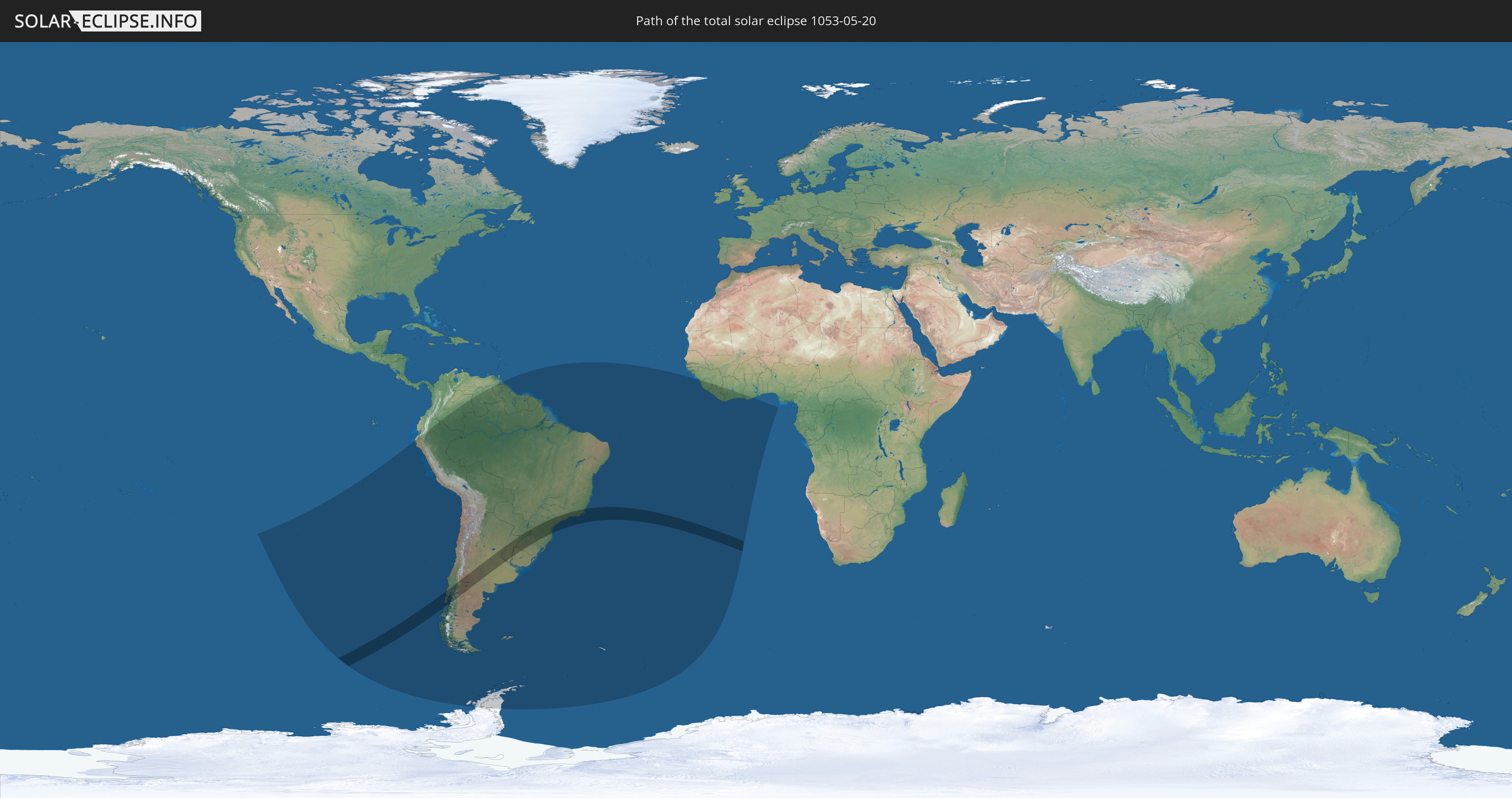
Die Sonnenfinsternis am 05/20/1053 kann man in 22 Ländern als partielle Sonnenfinsternis beobachten.
Der Finsternispfad verläuft durch 5 Länder. Nur in diesen Ländern ist sie als total Sonnenfinsternis zu sehen.
In den folgenden Ländern ist die Sonnenfinsternis total zu sehen
 Chile
Chile
 Brazil
 Argentina
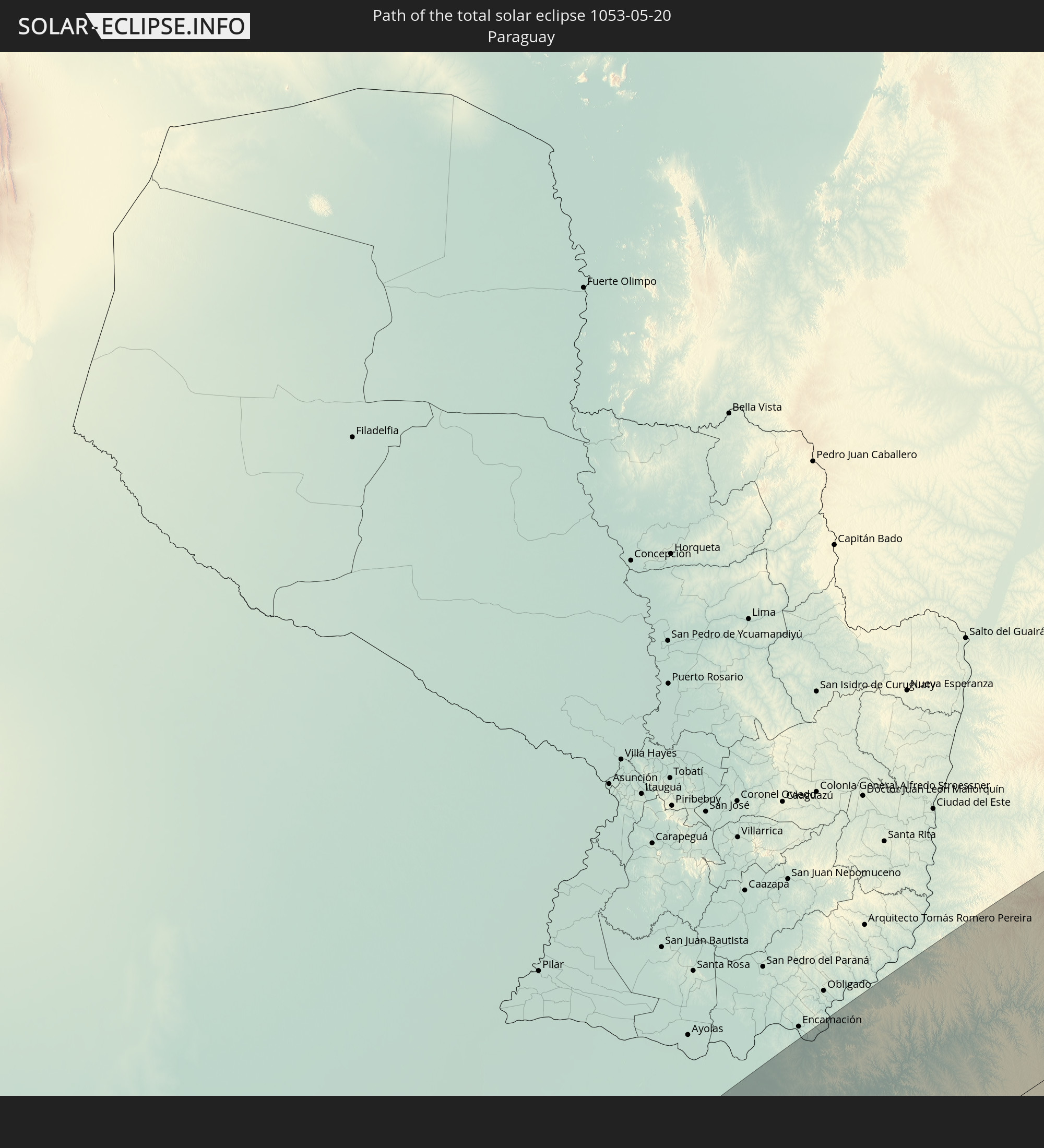 Paraguay
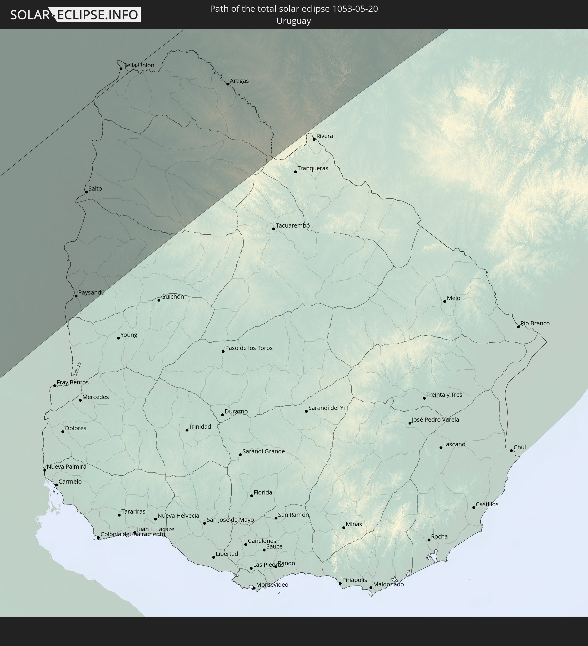 Uruguay
In den folgenden Ländern ist die Sonnenfinsternis partiell zu sehen


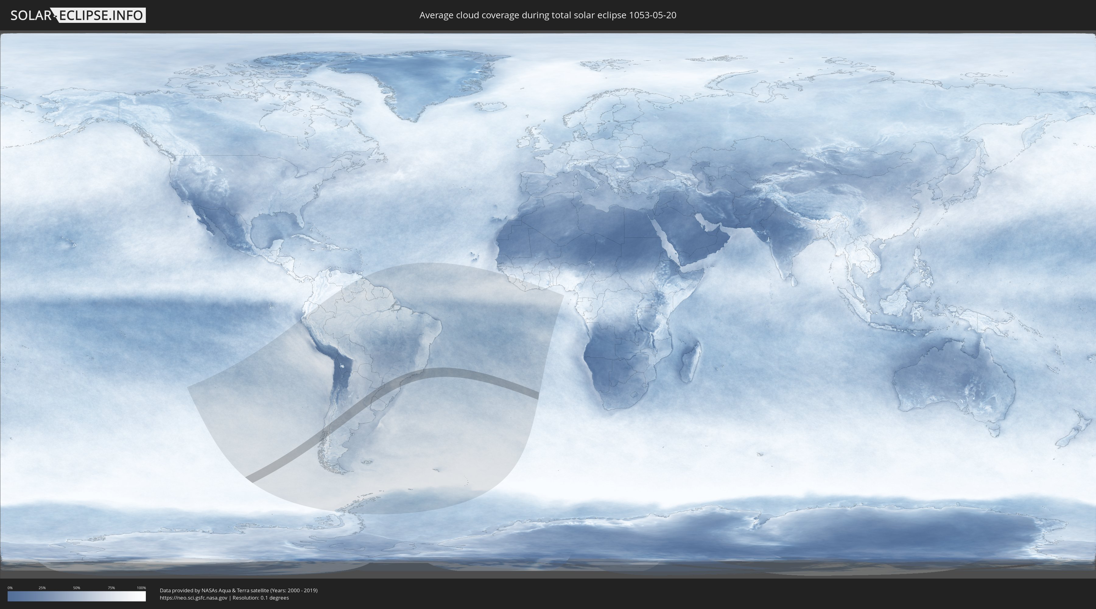
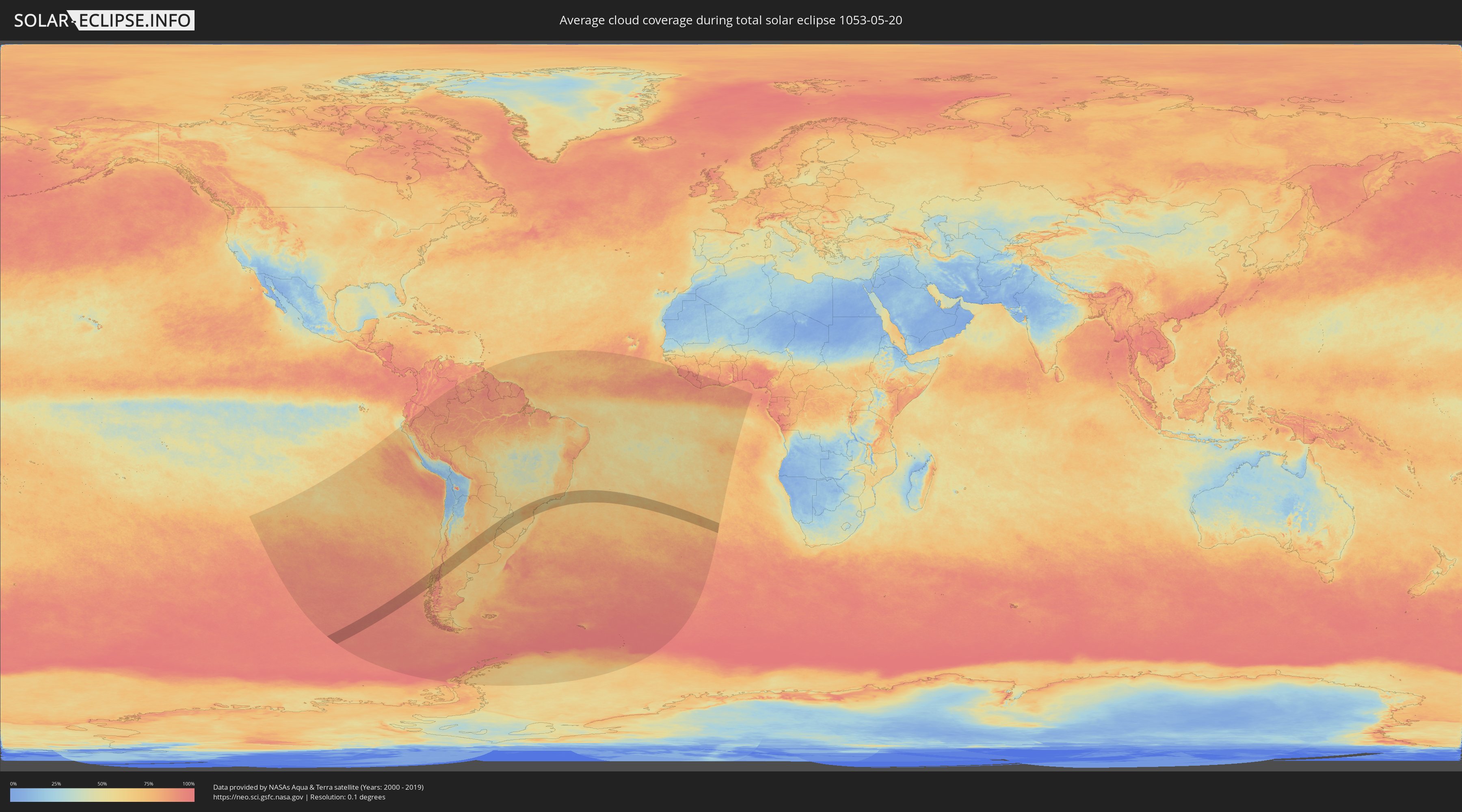
How will be the weather during the total solar eclipse on 05/20/1053?
Where is the best place to see the total solar eclipse of 05/20/1053?
The following maps show the average cloud coverage for the day of the total solar eclipse.
With the help of these maps, it is possible to find the place along the eclipse path, which has the best
chance of a cloudless sky.
Nevertheless, you should consider local circumstances and inform about the weather of your chosen
observation site.
The data is provided by NASAs satellites
AQUA and TERRA.
The cloud maps are averaged over a period of 19 years (2000 - 2019).
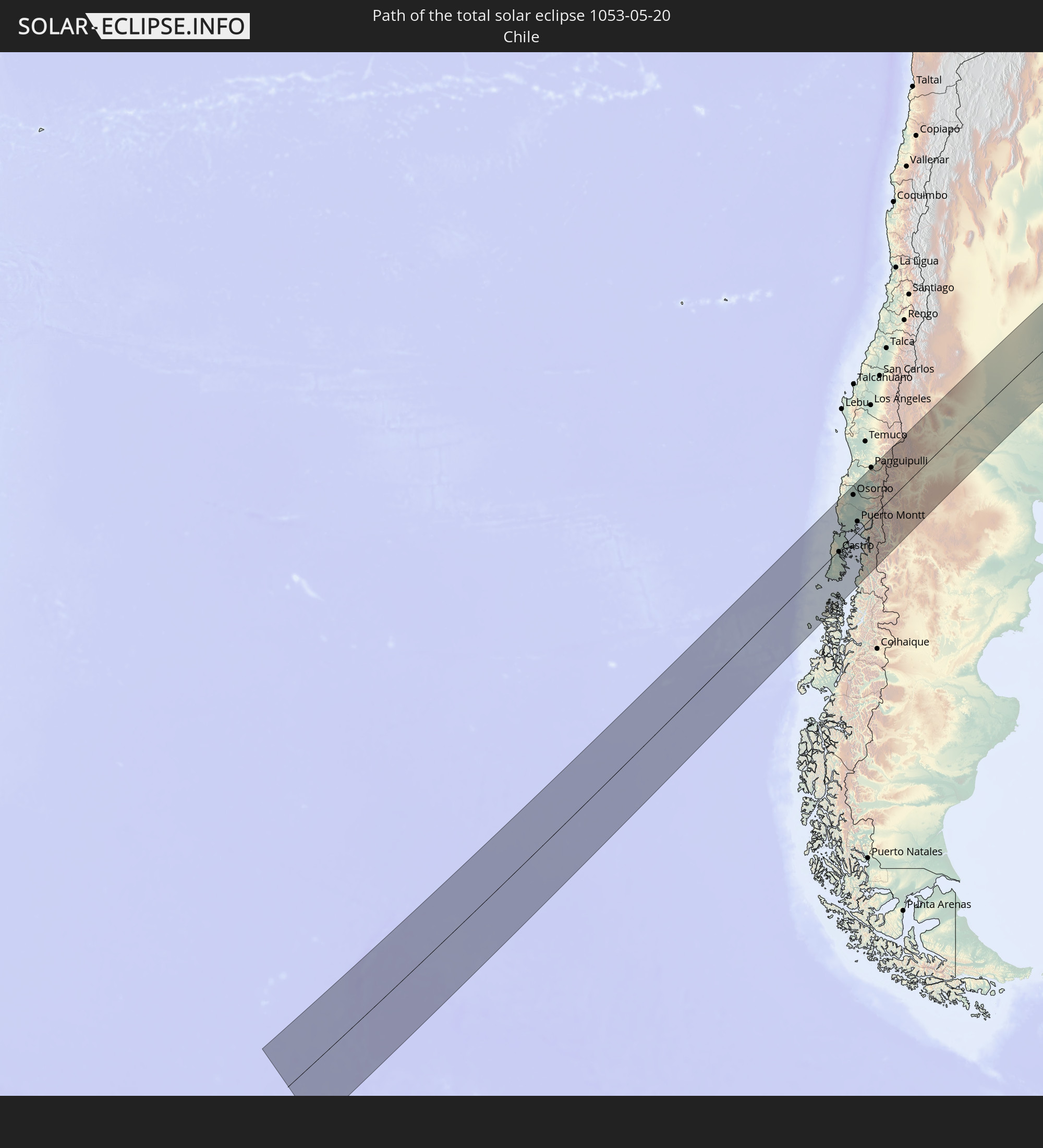
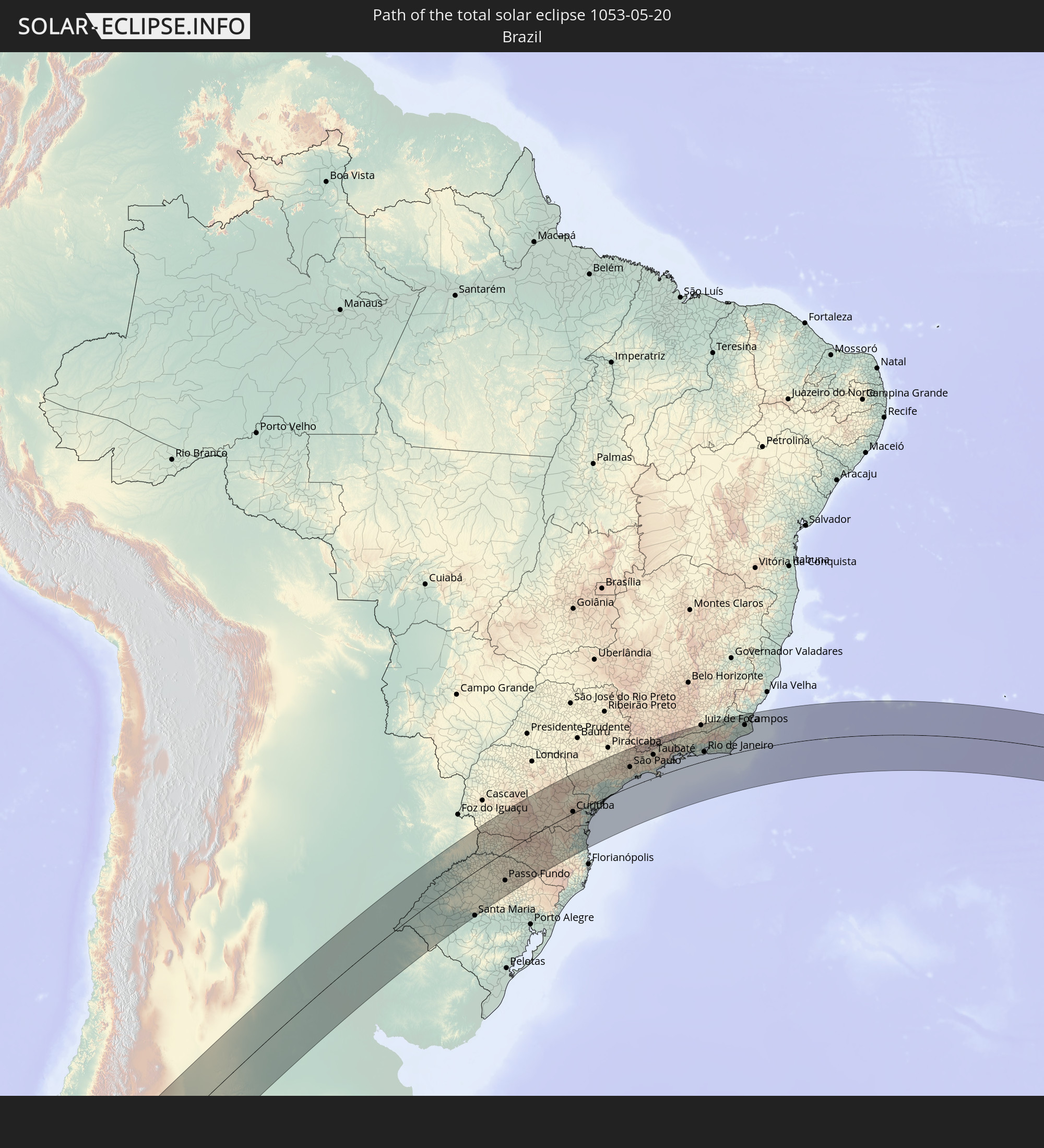
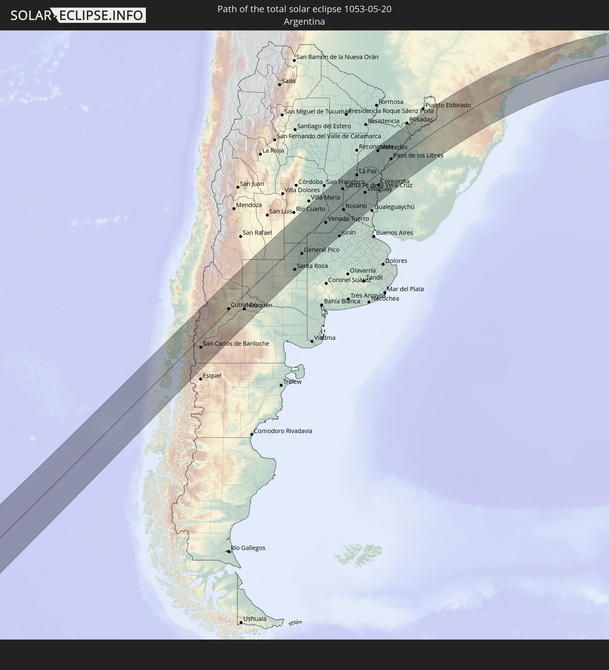
Detailed country maps
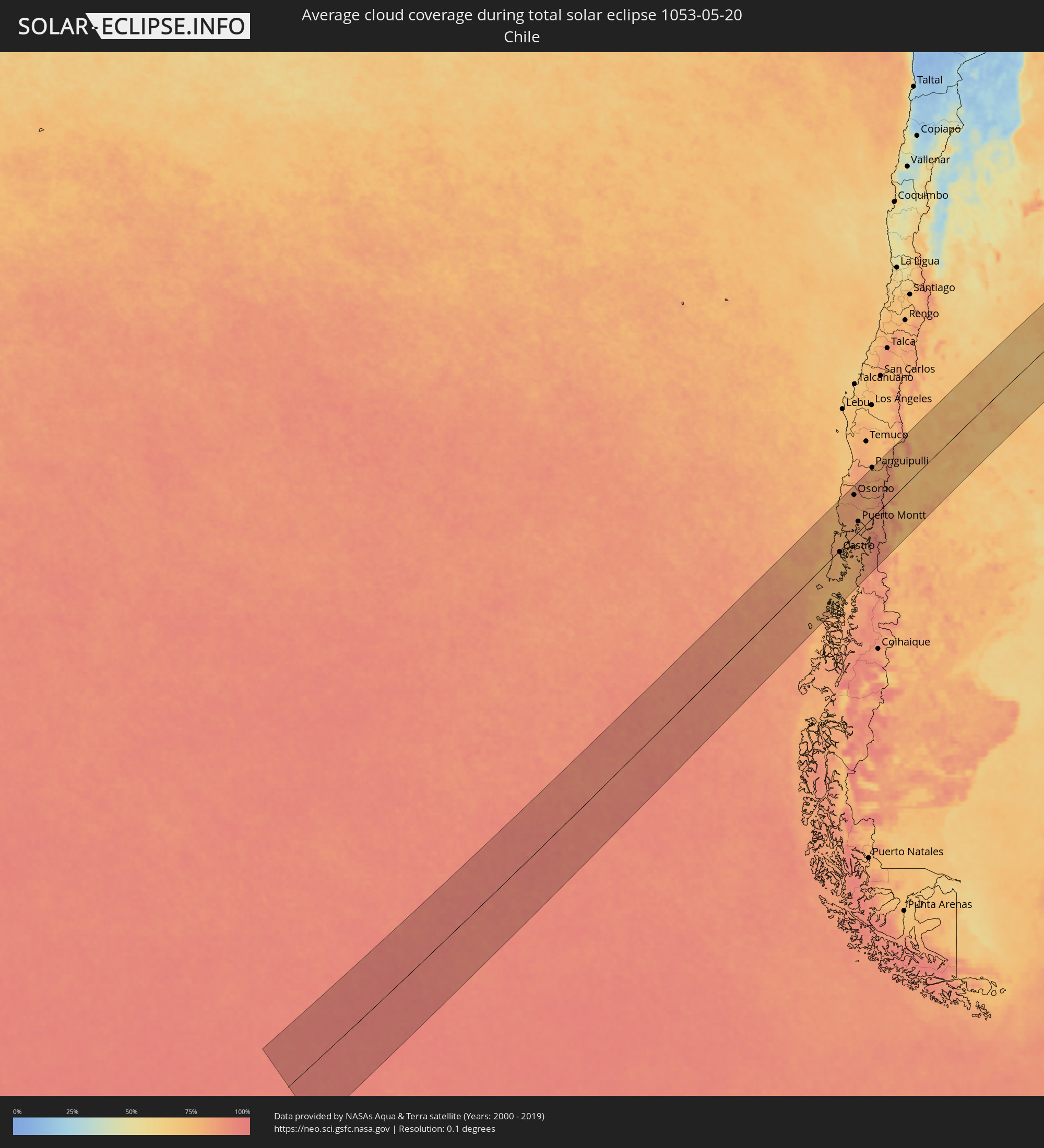 Chile
Chile
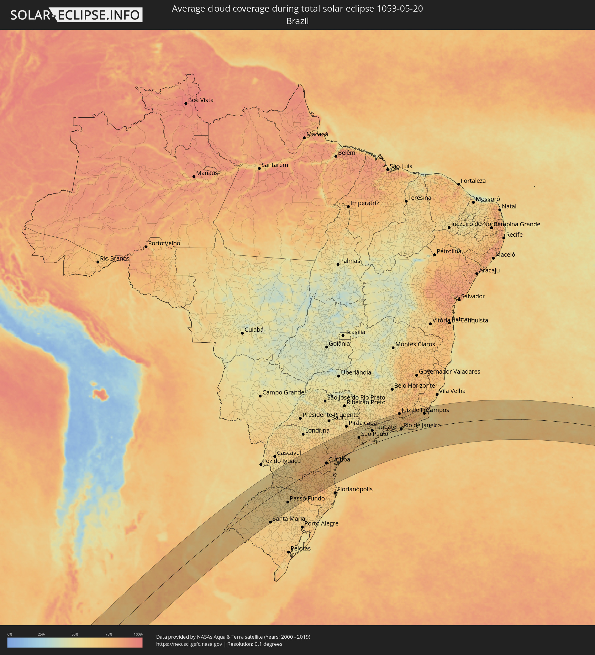 Brazil
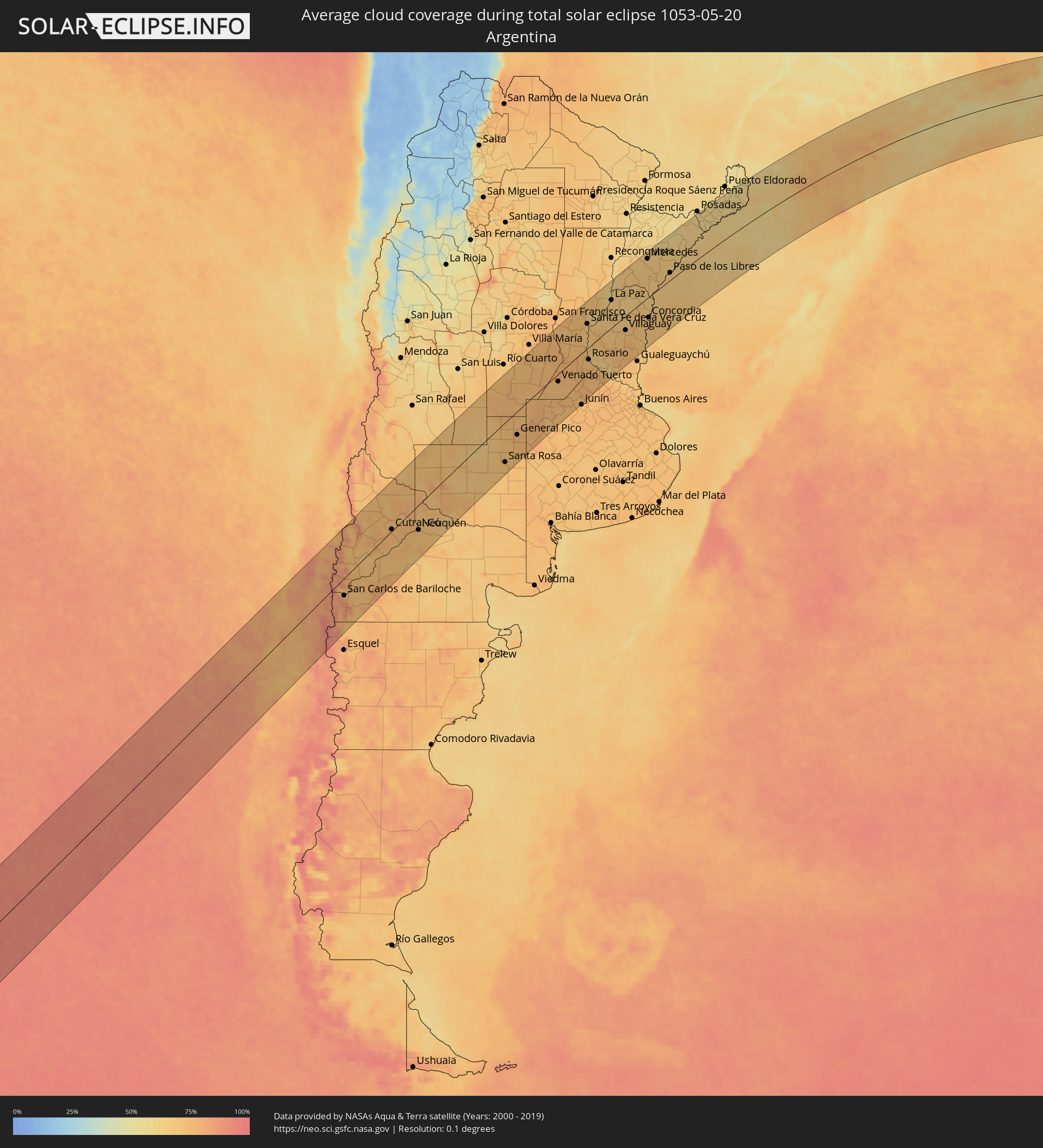 Argentina
 Paraguay
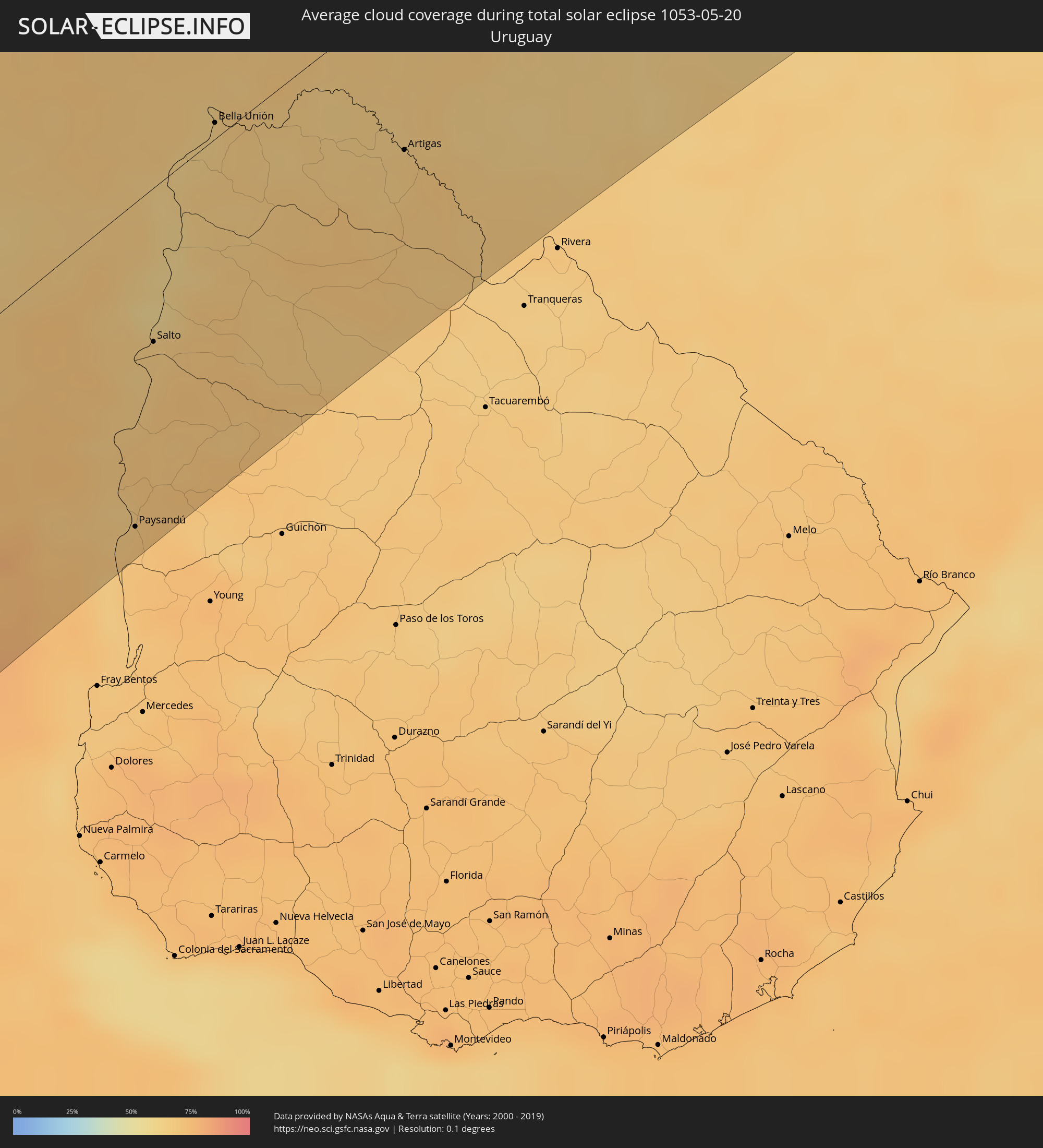 Uruguay
Cities inside the path of the eclipse
The following table shows all locations with a population of more than 5,000 inside the eclipse path. Cities which have more than 100,000 inhabitants are marked bold. A click at the locations opens a detailed map.
| City | Type | Eclipse duration | Local time of max. eclipse | Distance to central line | Ø Cloud coverage |
 Ancud, Los Lagos
|
total | - | 10:28:38 UTC-04:42 | 45 km | 77% |
|
Chonchi, Los Lagos
|
total | - | 10:28:46 UTC-04:42 | 16 km | 78% |
|
Castro, Los Lagos
|
total | - | 10:28:45 UTC-04:42 | 5 km | 77% |
|
Puerto Quellón, Los Lagos
|
total | - | 10:29:02 UTC-04:42 | 64 km | 75% |
|
Purranque, Los Lagos
|
total | - | 10:29:29 UTC-04:42 | 83 km | 82% |
|
Osorno, Los Lagos
|
total | - | 10:29:31 UTC-04:42 | 108 km | 83% |
|
Calbuco, Los Lagos
|
total | - | 10:29:34 UTC-04:42 | 13 km | 81% |
|
La Unión, Los Ríos
|
total | - | 10:29:35 UTC-04:42 | 128 km | 83% |
|
Frutillar, Los Lagos
|
total | - | 10:29:40 UTC-04:42 | 59 km | 80% |
|
Puerto Varas, Los Lagos
|
total | - | 10:29:45 UTC-04:42 | 40 km | 82% |
|
Río Bueno, Los Ríos
|
total | - | 10:29:46 UTC-04:42 | 117 km | 86% |
|
Puerto Montt, Los Lagos
|
total | - | 10:29:48 UTC-04:42 | 27 km | 80% |
|
Panguipulli, Araucanía
|
total | - | 10:30:40 UTC-04:42 | 135 km | 78% |
 San Martín de los Andes, Neuquén Province
|
total | - | 10:58:04 UTC-04:16 | 36 km | 83% |
|
San Carlos de Bariloche, Río Negro Province
|
total | - | 10:58:07 UTC-04:16 | 45 km | 72% |
|
Zapala, Neuquén Province
|
total | - | 11:00:08 UTC-04:16 | 58 km | 75% |
|
Cutral-Có, Neuquén Province
|
total | - | 11:01:25 UTC-04:16 | 5 km | 74% |
|
Plottier, Neuquén Province
|
total | - | 11:03:01 UTC-04:16 | 58 km | 75% |
|
Neuquén, Neuquén Province
|
total | - | 11:03:18 UTC-04:16 | 67 km | 75% |
|
Allen, Río Negro Province
|
total | - | 11:03:40 UTC-04:16 | 84 km | 72% |
|
General Roca, Río Negro Province
|
total | - | 11:04:03 UTC-04:16 | 103 km | 74% |
|
Villa Regina, Río Negro Province
|
total | - | 11:04:54 UTC-04:16 | 140 km | 71% |
|
Santa Rosa, La Pampa Province
|
total | - | 11:10:23 UTC-04:16 | 113 km | 74% |
|
General Pico, La Pampa Province
|
total | - | 11:11:43 UTC-04:16 | 68 km | 78% |
|
Laboulaye, Cordoba Province
|
total | - | 11:13:05 UTC-04:16 | 34 km | 76% |
|
Bell Ville, Cordoba Province
|
total | - | 11:15:13 UTC-04:16 | 115 km | 76% |
|
Marcos Juárez, Cordoba Province
|
total | - | 11:16:20 UTC-04:16 | 73 km | 76% |
|
Venado Tuerto, Santa Fe Province
|
total | - | 11:16:02 UTC-04:16 | 22 km | 75% |
|
Lincoln, Buenos Aires
|
total | - | 11:16:19 UTC-04:16 | 142 km | 75% |
|
Cañada de Gómez, Santa Fe Province
|
total | - | 11:17:41 UTC-04:16 | 20 km | 76% |
|
Casilda, Santa Fe Province
|
total | - | 11:18:00 UTC-04:16 | 13 km | 77% |
|
Esperanza, Santa Fe Province
|
total | - | 11:19:27 UTC-04:16 | 107 km | 73% |
|
Capitán Bermúdez, Santa Fe Province
|
total | - | 11:19:03 UTC-04:16 | 23 km | 72% |
|
Santa Fe de la Vera Cruz, Santa Fe Province
|
total | - | 11:19:49 UTC-04:16 | 77 km | 69% |
|
Rosario, Santa Fe Province
|
total | - | 11:19:08 UTC-04:16 | 38 km | 68% |
|
Diamante, Entre Ríos Province
|
total | - | 11:19:40 UTC-04:16 | 36 km | 68% |
|
San Justo, Santa Fe Province
|
total | - | 11:20:36 UTC-04:16 | 142 km | 73% |
|
Pergamino, Buenos Aires
|
total | - | 11:18:43 UTC-04:16 | 121 km | 74% |
|
Paraná, Entre Ríos Province
|
total | - | 11:20:07 UTC-04:16 | 57 km | 70% |
|
Arroyo Seco, Santa Fe Province
|
total | - | 11:19:17 UTC-04:16 | 63 km | 74% |
|
Villa Constitución, Santa Fe Province
|
total | - | 11:19:36 UTC-04:16 | 80 km | 70% |
|
San Nicolás de los Arroyos, Buenos Aires
|
total | - | 11:19:45 UTC-04:16 | 96 km | 73% |
|
Victoria, Entre Ríos Province
|
total | - | 11:20:19 UTC-04:16 | 40 km | 65% |
|
Santa Elena, Entre Ríos Province
|
total | - | 11:22:11 UTC-04:16 | 79 km | 67% |
|
La Paz, Entre Ríos Province
|
total | - | 11:22:37 UTC-04:16 | 88 km | 65% |
|
Esquina, Corrientes Province
|
total | - | 11:23:24 UTC-04:16 | 144 km | 63% |
|
Gualeguay, Entre Ríos Province
|
total | - | 11:21:45 UTC-04:16 | 136 km | 74% |
|
Villaguay, Entre Ríos Province
|
total | - | 11:23:10 UTC-04:16 | 45 km | 70% |
|
Concepción del Uruguay, Entre Ríos Province
|
total | - | 11:24:25 UTC-04:16 | 146 km | 66% |
 Paysandú, Paysandú
|
total | - | 11:56:49 UTC-03:44 | 142 km | 69% |
|
Mercedes, Corrientes Province
|
total | - | 11:27:11 UTC-04:16 | 130 km | 66% |
|
Curuzú Cuatiá, Corrientes Province
|
total | - | 11:26:45 UTC-04:16 | 75 km | 68% |
|
Concordia, Entre Ríos Province
|
total | - | 11:25:38 UTC-04:16 | 66 km | 64% |
|
Chajarí, Entre Ríos Province
|
total | - | 11:26:12 UTC-04:16 | 13 km | 65% |
|
Salto, Salto
|
total | - | 11:57:43 UTC-03:44 | 68 km | 64% |
|
Monte Caseros, Corrientes Province
|
total | - | 11:27:19 UTC-04:16 | 10 km | 64% |
|
Bella Unión, Artigas
|
total | - | 11:59:21 UTC-03:44 | 7 km | 64% |
 Uruguaiana, Rio Grande do Sul
|
total | - | 12:39:15 UTC-03:06 | 21 km | 67% |
|
Paso de los Libres, Corrientes Province
|
total | - | 11:28:57 UTC-04:16 | 25 km | 67% |
|
Artigas, Artigas
|
total | - | 12:01:44 UTC-03:44 | 72 km | 65% |
|
Santo Tomé, Corrientes Province
|
total | - | 11:32:17 UTC-04:16 | 67 km | 65% |
|
Gobernador Ingeniero Valentín Virasoro, Corrientes Province
|
total | - | 11:32:44 UTC-04:16 | 112 km | 62% |
|
Garupá, Misiones Province
|
total | - | 11:33:42 UTC-04:16 | 152 km | 62% |
|
Jardín América, Misiones Province
|
total | - | 11:35:30 UTC-04:16 | 158 km | 57% |
|
Oberá, Misiones Province
|
total | - | 11:35:20 UTC-04:16 | 111 km | 63% |
|
Aristóbulo del Valle, Misiones Province
|
total | - | 11:36:13 UTC-04:16 | 135 km | 56% |
|
El Soberbio, Misiones Province
|
total | - | 11:37:40 UTC-04:16 | 78 km | 62% |
|
San Vicente, Misiones Province
|
total | - | 11:38:28 UTC-04:16 | 137 km | 58% |
|
Santa Maria, Rio Grande do Sul
|
total | - | 12:46:45 UTC-03:06 | 162 km | 65% |
|
Chapecó, Santa Catarina
|
total | - | 12:51:57 UTC-03:06 | 11 km | 63% |
|
Passo Fundo, Rio Grande do Sul
|
total | - | 12:51:19 UTC-03:06 | 109 km | 58% |
|
Guarapuava, Paraná
|
total | - | 12:56:26 UTC-03:06 | 115 km | 67% |
|
Ponta Grossa, Paraná
|
total | - | 12:59:56 UTC-03:06 | 81 km | 71% |
|
Araucária, Paraná
|
total | - | 13:01:14 UTC-03:06 | 4 km | 76% |
|
Curitiba, Paraná
|
total | - | 13:01:45 UTC-03:06 | 7 km | 76% |
|
Colombo, Paraná
|
total | - | 13:02:01 UTC-03:06 | 18 km | 75% |
|
Jaraguá do Sul, Santa Catarina
|
total | - | 13:01:08 UTC-03:06 | 108 km | 72% |
|
Blumenau, Santa Catarina
|
total | - | 13:00:40 UTC-03:06 | 150 km | 70% |
|
Joinville, Santa Catarina
|
total | - | 13:01:52 UTC-03:06 | 100 km | 72% |
|
Itajaí, Santa Catarina
|
total | - | 13:01:40 UTC-03:06 | 168 km | 73% |
|
Paranaguá, Paraná
|
total | - | 13:03:29 UTC-03:06 | 36 km | 69% |
|
Itapetininga, São Paulo
|
total | - | 13:06:46 UTC-03:06 | 138 km | 66% |
|
Sorocaba, São Paulo
|
total | - | 13:08:21 UTC-03:06 | 123 km | 68% |
|
Itu, São Paulo
|
total | - | 13:09:00 UTC-03:06 | 141 km | 64% |
|
Indaiatuba, São Paulo
|
total | - | 13:09:25 UTC-03:06 | 156 km | 66% |
|
Campinas, São Paulo
|
total | - | 13:10:00 UTC-03:06 | 169 km | 64% |
|
Cotia, São Paulo
|
total | - | 13:09:33 UTC-03:06 | 92 km | 66% |
|
Jundiaí, São Paulo
|
total | - | 13:10:07 UTC-03:06 | 133 km | 65% |
|
Osasco, São Paulo
|
total | - | 13:09:57 UTC-03:06 | 94 km | 66% |
|
Francisco Morato, São Paulo
|
total | - | 13:10:21 UTC-03:06 | 118 km | 62% |
|
São Paulo, São Paulo
|
total | - | 13:10:19 UTC-03:06 | 87 km | 69% |
|
São Bernardo do Campo, São Paulo
|
total | - | 13:10:20 UTC-03:06 | 69 km | 65% |
|
Atibaia, São Paulo
|
total | - | 13:11:01 UTC-03:06 | 128 km | 61% |
|
Bragança Paulista, São Paulo
|
total | - | 13:11:13 UTC-03:06 | 145 km | 57% |
|
Ribeirão Pires, São Paulo
|
total | - | 13:10:41 UTC-03:06 | 61 km | 67% |
|
Itaquaquecetuba, São Paulo
|
total | - | 13:11:06 UTC-03:06 | 82 km | 69% |
|
Santos, São Paulo
|
total | - | 13:10:36 UTC-03:06 | 33 km | 59% |
|
Mogi das Cruzes, São Paulo
|
total | - | 13:11:27 UTC-03:06 | 73 km | 67% |
|
Jacareí, São Paulo
|
total | - | 13:12:15 UTC-03:06 | 87 km | 68% |
|
São José dos Campos, São Paulo
|
total | - | 13:12:35 UTC-03:06 | 97 km | 66% |
|
Taubaté, São Paulo
|
total | - | 13:13:35 UTC-03:06 | 102 km | 65% |
|
Guaratinguetá, São Paulo
|
total | - | 13:14:42 UTC-03:06 | 112 km | 60% |
|
Resende, Rio de Janeiro
|
total | - | 13:16:56 UTC-03:06 | 125 km | 65% |
|
Angra dos Reis, Rio de Janeiro
|
total | - | 13:16:38 UTC-03:06 | 63 km | 58% |
|
Volta Redonda, Rio de Janeiro
|
total | - | 13:17:43 UTC-03:06 | 108 km | 64% |
|
Itaguaí, Rio de Janeiro
|
total | - | 13:18:08 UTC-03:06 | 64 km | 59% |
|
Nova Iguaçu, Rio de Janeiro
|
total | - | 13:19:01 UTC-03:06 | 64 km | 65% |
|
Juiz de Fora, Minas Gerais
|
total | - | 13:20:25 UTC-03:06 | 168 km | 72% |
|
Rio de Janeiro, Rio de Janeiro
|
total | - | 13:19:26 UTC-03:06 | 42 km | 59% |
|
Petrópolis, Rio de Janeiro
|
total | - | 13:19:58 UTC-03:06 | 84 km | 65% |
|
Teresópolis, Rio de Janeiro
|
total | - | 13:20:34 UTC-03:06 | 88 km | 72% |
|
Itaboraí, Rio de Janeiro
|
total | - | 13:20:28 UTC-03:06 | 50 km | 64% |
|
Nova Friburgo, Rio de Janeiro
|
total | - | 13:21:48 UTC-03:06 | 91 km | 76% |
|
Araruama, Rio de Janeiro
|
total | - | 13:21:33 UTC-03:06 | 22 km | 61% |
|
Cabo Frio, Rio de Janeiro
|
total | - | 13:22:17 UTC-03:06 | 13 km | 62% |
|
Macaé, Rio de Janeiro
|
total | - | 13:23:28 UTC-03:06 | 63 km | 60% |
|
Campos, Rio de Janeiro
|
total | - | 13:25:16 UTC-03:06 | 120 km | 72% |