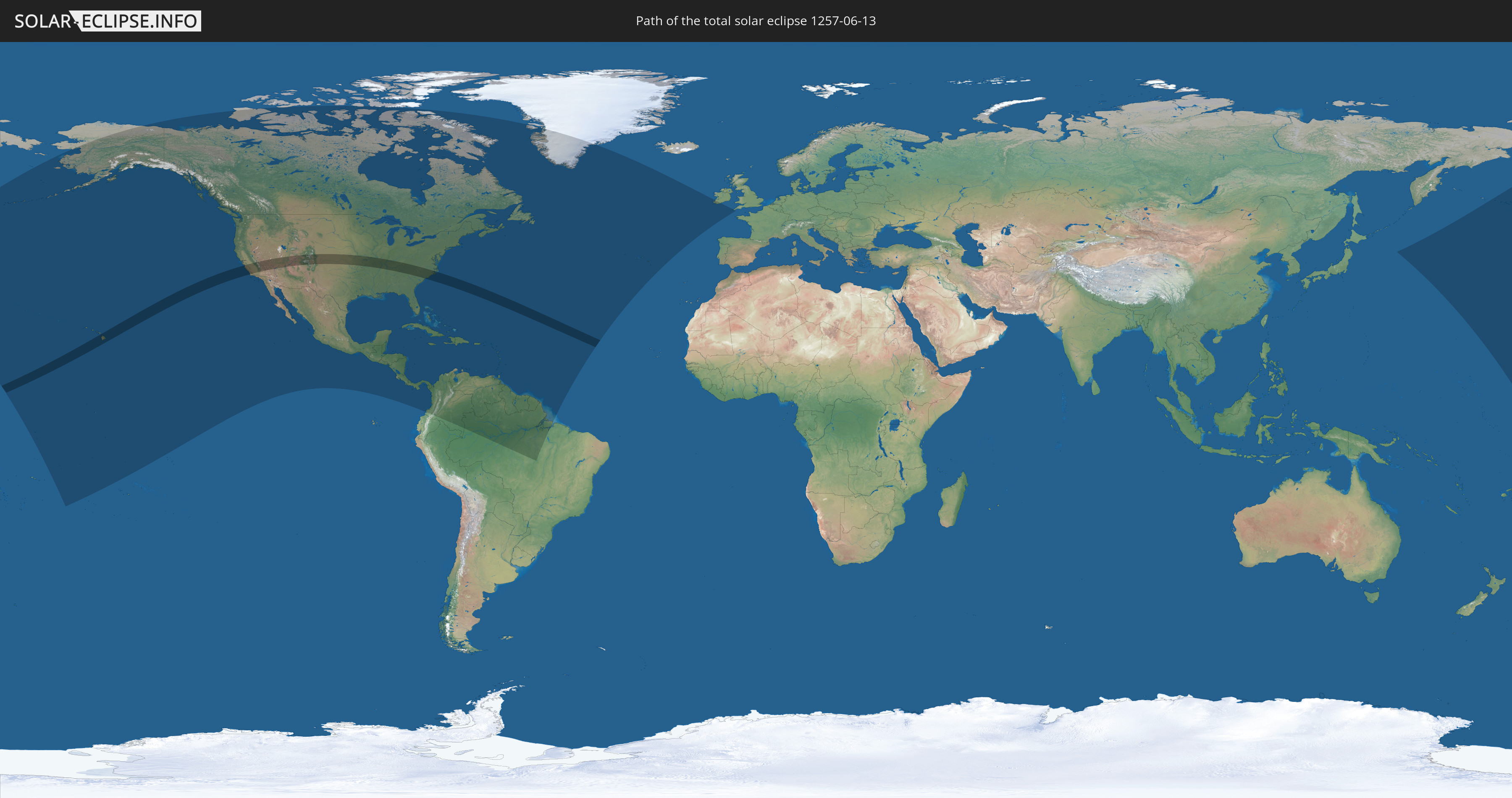
Total solar eclipse of 06/13/1257
| Day of week: | Wednesday |
| Maximum duration of eclipse: | 06m11s |
| Maximum width of eclipse path: | 255 km |
| Saros cycle: | 115 |
| Coverage: | 100% |
| Magnitude: | 1.0765 |
| Gamma: | 0.2409 |
Wo kann man die Sonnenfinsternis vom 06/13/1257 sehen?
Die Sonnenfinsternis am 06/13/1257 kann man in 51 Ländern als partielle Sonnenfinsternis beobachten.
Der Finsternispfad verläuft durch ein Land. Nur in diesem Land ist sie als total Sonnenfinsternis zu sehen.
In den folgenden Ländern ist die Sonnenfinsternis total zu sehen
 United States
In den folgenden Ländern ist die Sonnenfinsternis partiell zu sehen
 United States
 United States Minor Outlying Islands
 Kiribati
 Cook Islands
 French Polynesia
 Canada
 Mexico
 Greenland
 Guatemala
 El Salvador
 Honduras
 Belize
 Nicaragua
 Costa Rica
 Cuba
Cuba
 Panama
 Colombia
 Cayman Islands
 The Bahamas
 Jamaica
 Haiti
Haiti
 Brazil
 Venezuela
 Turks and Caicos Islands
 Dominican Republic
 Aruba
Aruba
 Puerto Rico
 United States Virgin Islands
 Bermuda
 British Virgin Islands
 Anguilla
 Collectivity of Saint Martin
 Saint Barthélemy
 Saint Kitts and Nevis
 Antigua and Barbuda
 Montserrat
 Trinidad and Tobago
 Guadeloupe
 Grenada
 Dominica
 Saint Vincent and the Grenadines
 Guyana
 Martinique
 Saint Lucia
 Barbados
 Suriname
 Saint Pierre and Miquelon
 French Guiana
 Portugal
 Republic of Ireland
 United Kingdom
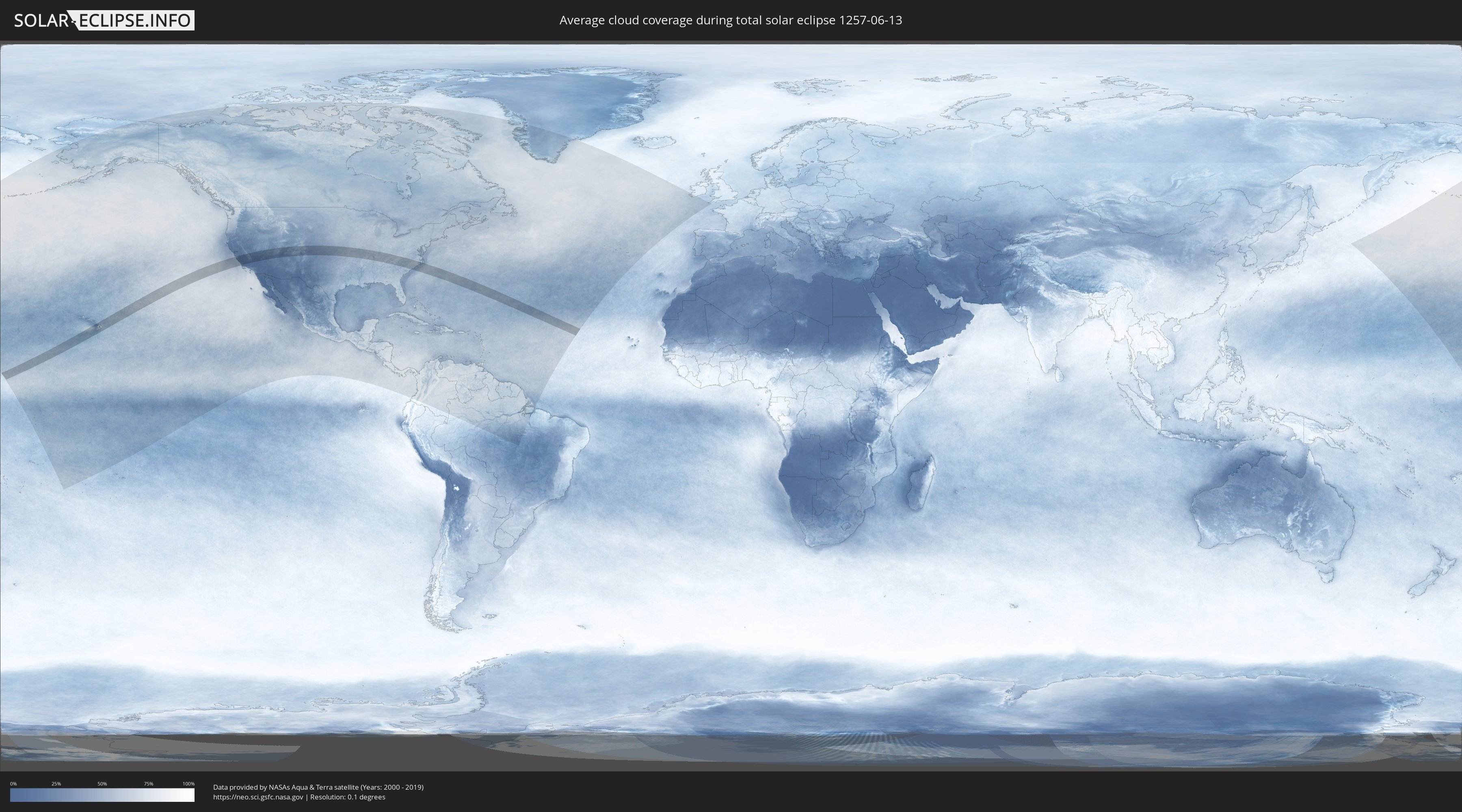
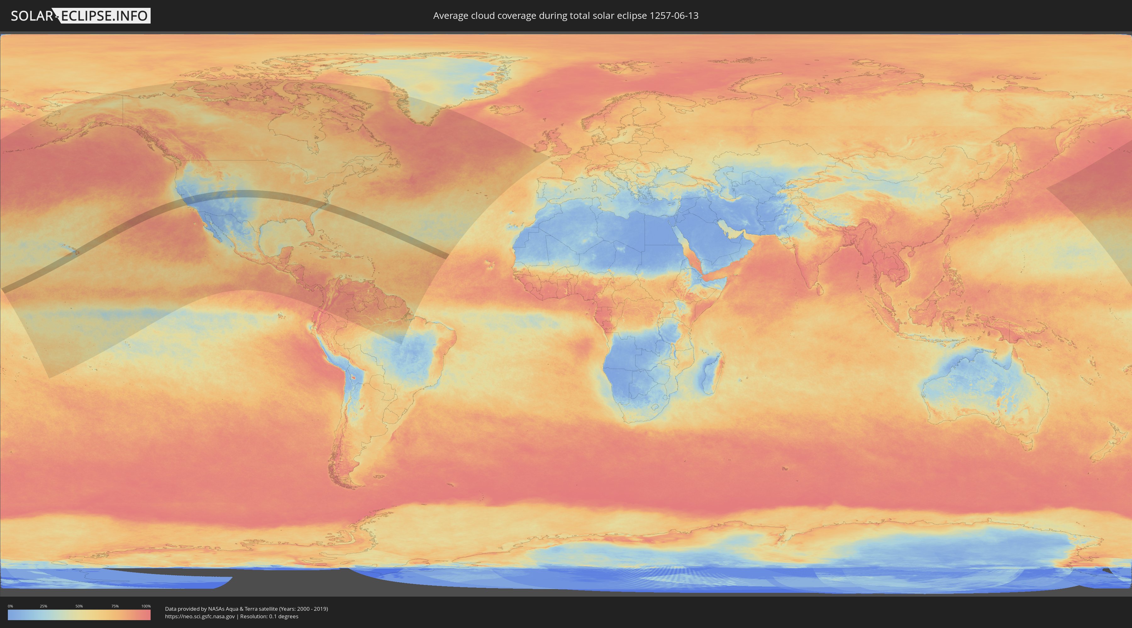
How will be the weather during the total solar eclipse on 06/13/1257?
Where is the best place to see the total solar eclipse of 06/13/1257?
The following maps show the average cloud coverage for the day of the total solar eclipse.
With the help of these maps, it is possible to find the place along the eclipse path, which has the best
chance of a cloudless sky.
Nevertheless, you should consider local circumstances and inform about the weather of your chosen
observation site.
The data is provided by NASAs satellites
AQUA and TERRA.
The cloud maps are averaged over a period of 19 years (2000 - 2019).
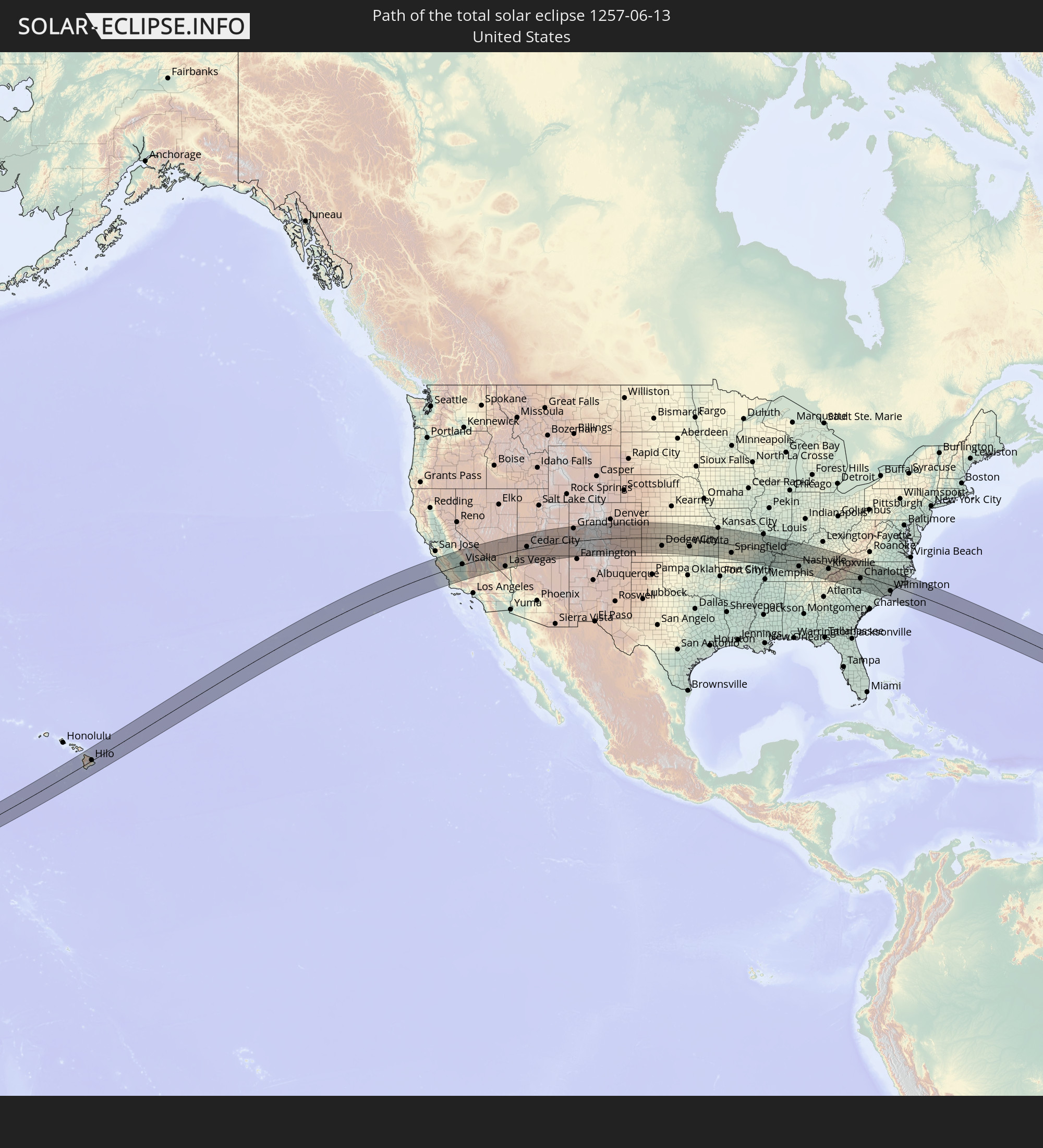
Detailed country maps
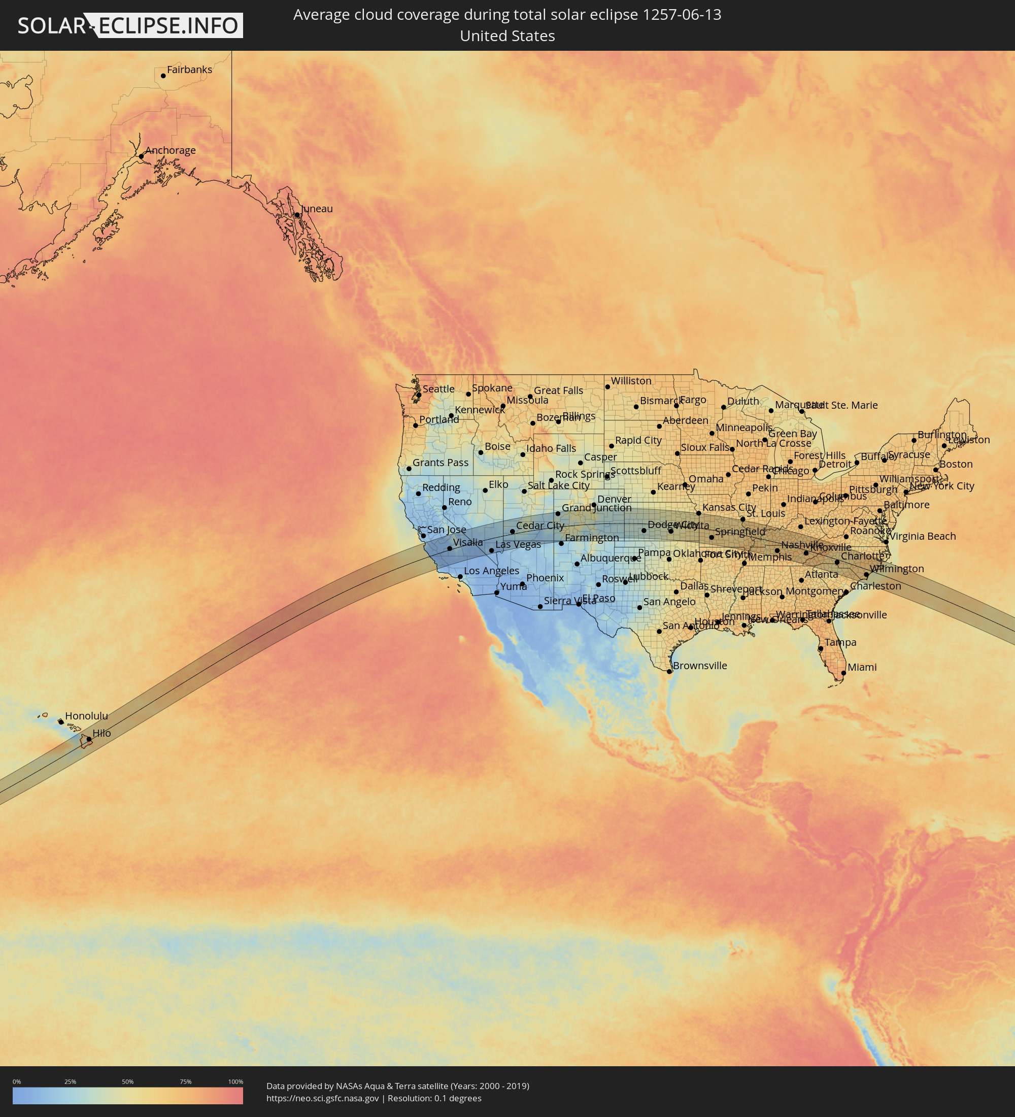 United States
Cities inside the path of the eclipse
The following table shows all locations with a population of more than 5,000 inside the eclipse path. Cities which have more than 100,000 inhabitants are marked bold. A click at the locations opens a detailed map.
| City | Type | Eclipse duration | Local time of max. eclipse | Distance to central line | Ø Cloud coverage |
|
Kailua-Kona, Hawaii
|
total | - | 07:26:43 UTC-10:30 | 45 km | 63% |
|
Hilo, Hawaii
|
total | - | 07:27:19 UTC-10:30 | 4 km | 85% |
|
Hawaiian Paradise Park, Hawaii
|
total | - | 07:27:13 UTC-10:30 | 16 km | 83% |
|
Seaside, California
|
total | - | 11:03:54 UTC-08:00 | 105 km | 43% |
|
Salinas, California
|
total | - | 11:04:21 UTC-08:00 | 106 km | 29% |
|
Hollister, California
|
total | - | 11:05:02 UTC-08:00 | 117 km | 14% |
|
Soledad, California
|
total | - | 11:04:46 UTC-08:00 | 70 km | 10% |
|
King City, California
|
total | - | 11:04:58 UTC-08:00 | 42 km | 8% |
|
Los Banos, California
|
total | - | 11:06:20 UTC-08:00 | 123 km | 12% |
|
Los Osos, California
|
total | - | 11:04:42 UTC-08:00 | 62 km | 29% |
|
Paso Robles, California
|
total | - | 11:05:18 UTC-08:00 | 32 km | 11% |
|
Atascadero, California
|
total | - | 11:05:12 UTC-08:00 | 48 km | 12% |
|
San Luis Obispo, California
|
total | - | 11:05:02 UTC-08:00 | 70 km | 18% |
|
Arroyo Grande, California
|
total | - | 11:05:01 UTC-08:00 | 89 km | 39% |
|
Santa Maria, California
|
total | - | 11:05:11 UTC-08:00 | 111 km | 20% |
|
Coalinga, California
|
total | - | 11:06:28 UTC-08:00 | 12 km | 9% |
|
Chowchilla, California
|
total | - | 11:07:34 UTC-08:00 | 114 km | 13% |
|
Avenal, California
|
total | - | 11:06:49 UTC-08:00 | 8 km | 7% |
|
Madera, California
|
total | - | 11:07:50 UTC-08:00 | 91 km | 11% |
|
Kerman, California
|
total | - | 11:07:37 UTC-08:00 | 66 km | 10% |
|
Fresno, California
|
total | - | 11:08:14 UTC-08:00 | 61 km | 10% |
|
Hanford, California
|
total | - | 11:08:07 UTC-08:00 | 13 km | 11% |
|
Corcoran, California
|
total | - | 11:08:05 UTC-08:00 | 14 km | 10% |
|
Sanger, California
|
total | - | 11:08:38 UTC-08:00 | 51 km | 11% |
|
Reedley, California
|
total | - | 11:08:45 UTC-08:00 | 36 km | 10% |
|
Wasco, California
|
total | - | 11:08:06 UTC-08:00 | 73 km | 9% |
|
Visalia, California
|
total | - | 11:08:51 UTC-08:00 | 4 km | 10% |
|
Delano, California
|
total | - | 11:08:27 UTC-08:00 | 57 km | 10% |
|
Lindsay, California
|
total | - | 11:09:10 UTC-08:00 | 15 km | 12% |
|
Bakersfield, California
|
total | - | 11:08:35 UTC-08:00 | 105 km | 6% |
|
Porterville, California
|
total | - | 11:09:12 UTC-08:00 | 32 km | 11% |
|
Arvin, California
|
total | - | 11:08:51 UTC-08:00 | 128 km | 6% |
|
Ridgecrest, California
|
total | - | 11:11:42 UTC-08:00 | 113 km | 8% |
|
Pahrump, Nevada
|
total | - | 11:15:50 UTC-08:00 | 89 km | 9% |
|
Enterprise, Nevada
|
total | - | 11:17:20 UTC-08:00 | 124 km | 10% |
|
Las Vegas, Nevada
|
total | - | 11:17:40 UTC-08:00 | 110 km | 10% |
|
Mesquite, Nevada
|
total | - | 11:20:25 UTC-08:00 | 63 km | 15% |
|
Saint George, Utah
|
total | - | 12:21:39 UTC-07:00 | 39 km | 17% |
|
Hurricane, Utah
|
total | - | 12:22:20 UTC-07:00 | 36 km | 16% |
|
Cedar City, Utah
|
total | - | 12:23:06 UTC-07:00 | 15 km | 25% |
|
Fruita, Colorado
|
total | - | 12:32:55 UTC-07:00 | 120 km | 29% |
|
Grand Junction, Colorado
|
total | - | 12:33:16 UTC-07:00 | 108 km | 29% |
|
Durango, Colorado
|
total | - | 12:34:20 UTC-07:00 | 96 km | 29% |
|
Montrose, Colorado
|
total | - | 12:34:35 UTC-07:00 | 37 km | 32% |
|
Cañon City, Colorado
|
total | - | 12:40:13 UTC-07:00 | 15 km | 37% |
|
Castle Rock, Colorado
|
total | - | 12:41:03 UTC-07:00 | 117 km | 40% |
|
Colorado Springs, Colorado
|
total | - | 12:41:07 UTC-07:00 | 57 km | 45% |
|
Fountain, Colorado
|
total | - | 12:41:22 UTC-07:00 | 40 km | 36% |
|
Black Forest, Colorado
|
total | - | 12:41:22 UTC-07:00 | 76 km | 42% |
|
Pueblo, Colorado
|
total | - | 12:41:34 UTC-07:00 | 8 km | 28% |
|
Garden City, Kansas
|
total | - | 13:49:31 UTC-06:00 | 43 km | 31% |
|
Dodge City, Kansas
|
total | - | 13:51:22 UTC-06:00 | 65 km | 33% |
|
Hays, Kansas
|
total | - | 13:52:26 UTC-06:00 | 62 km | 43% |
|
Great Bend, Kansas
|
total | - | 13:53:44 UTC-06:00 | 8 km | 43% |
|
Hutchinson, Kansas
|
total | - | 13:55:32 UTC-06:00 | 21 km | 43% |
|
McPherson, Kansas
|
total | - | 13:55:56 UTC-06:00 | 15 km | 45% |
|
Salina, Kansas
|
total | - | 13:55:51 UTC-06:00 | 67 km | 49% |
|
Newton, Kansas
|
total | - | 13:56:43 UTC-06:00 | 19 km | 44% |
|
Wichita, Kansas
|
total | - | 13:56:52 UTC-06:00 | 58 km | 50% |
|
Derby, Kansas
|
total | - | 13:57:04 UTC-06:00 | 74 km | 48% |
|
Andover, Kansas
|
total | - | 13:57:16 UTC-06:00 | 54 km | 48% |
|
Arkansas City, Kansas
|
total | - | 13:57:45 UTC-06:00 | 126 km | 49% |
|
Winfield, Kansas
|
total | - | 13:57:45 UTC-06:00 | 106 km | 50% |
|
El Dorado, Kansas
|
total | - | 13:57:46 UTC-06:00 | 41 km | 48% |
|
Junction City, Kansas
|
total | - | 13:57:17 UTC-06:00 | 94 km | 49% |
|
Manhattan, Kansas
|
total | - | 13:57:43 UTC-06:00 | 113 km | 50% |
|
Emporia, Kansas
|
total | - | 13:58:50 UTC-06:00 | 30 km | 54% |
|
Topeka, Kansas
|
total | - | 13:59:29 UTC-06:00 | 106 km | 55% |
|
Ottawa, Kansas
|
total | - | 14:00:29 UTC-06:00 | 62 km | 51% |
|
Lawrence, Kansas
|
total | - | 14:00:21 UTC-06:00 | 101 km | 53% |
|
Olathe, Kansas
|
total | - | 14:01:11 UTC-06:00 | 96 km | 54% |
|
Pittsburg, Kansas
|
total | - | 14:02:13 UTC-06:00 | 66 km | 59% |
|
Overland Park, Kansas
|
total | - | 14:01:24 UTC-06:00 | 108 km | 55% |
|
Kansas City, Missouri
|
total | - | 14:01:30 UTC-06:00 | 122 km | 55% |
|
Belton, Missouri
|
total | - | 14:01:45 UTC-06:00 | 91 km | 55% |
|
Joplin, Missouri
|
total | - | 14:02:46 UTC-06:00 | 99 km | 57% |
|
Lee's Summit, Missouri
|
total | - | 14:01:59 UTC-06:00 | 104 km | 54% |
|
Neosho, Missouri
|
total | - | 14:03:10 UTC-06:00 | 122 km | 55% |
|
East Independence, Missouri
|
total | - | 14:01:55 UTC-06:00 | 124 km | 56% |
|
Carthage, Missouri
|
total | - | 14:03:07 UTC-06:00 | 87 km | 57% |
|
Grain Valley, Missouri
|
total | - | 14:02:15 UTC-06:00 | 117 km | 58% |
|
Warrensburg, Missouri
|
total | - | 14:03:16 UTC-06:00 | 95 km | 63% |
|
Republic, Missouri
|
total | - | 14:04:44 UTC-06:00 | 83 km | 62% |
|
Springfield, Missouri
|
total | - | 14:05:01 UTC-06:00 | 70 km | 64% |
|
Nixa, Missouri
|
total | - | 14:05:08 UTC-06:00 | 89 km | 62% |
|
Sedalia, Missouri
|
total | - | 14:04:13 UTC-06:00 | 95 km | 61% |
|
Lebanon, Missouri
|
total | - | 14:05:55 UTC-06:00 | 11 km | 63% |
|
Jefferson City, Missouri
|
total | - | 14:06:13 UTC-06:00 | 95 km | 60% |
|
Fort Leonard Wood, Missouri
|
total | - | 14:06:50 UTC-06:00 | 1 km | 61% |
|
West Plains, Missouri
|
total | - | 14:08:03 UTC-06:00 | 104 km | 61% |
|
Rolla, Missouri
|
total | - | 14:07:22 UTC-06:00 | 32 km | 61% |
|
Washington, Missouri
|
total | - | 14:08:17 UTC-06:00 | 110 km | 57% |
|
Wildwood, Missouri
|
total | - | 14:08:52 UTC-06:00 | 118 km | 59% |
|
Farmington, Missouri
|
total | - | 14:09:53 UTC-06:00 | 34 km | 63% |
|
Kirkwood, Missouri
|
total | - | 14:09:18 UTC-06:00 | 122 km | 63% |
|
Festus, Missouri
|
total | - | 14:09:36 UTC-06:00 | 82 km | 57% |
|
Poplar Bluff, Missouri
|
total | - | 14:10:42 UTC-06:00 | 78 km | 68% |
|
Oakville, Missouri
|
total | - | 14:09:34 UTC-06:00 | 111 km | 61% |
|
Cahokia, Illinois
|
total | - | 14:09:41 UTC-06:00 | 124 km | 64% |
|
Belleville, Illinois
|
total | - | 14:10:05 UTC-06:00 | 122 km | 67% |
|
Jackson, Missouri
|
total | - | 14:11:30 UTC-06:00 | 3 km | 66% |
|
Sikeston, Missouri
|
total | - | 14:12:02 UTC-06:00 | 51 km | 71% |
|
Cape Girardeau, Missouri
|
total | - | 14:11:49 UTC-06:00 | 3 km | 63% |
|
Carbondale, Illinois
|
total | - | 14:12:00 UTC-06:00 | 49 km | 59% |
|
Marion, Illinois
|
total | - | 14:12:29 UTC-06:00 | 54 km | 61% |
|
Mount Vernon, Illinois
|
total | - | 14:12:04 UTC-06:00 | 119 km | 67% |
|
Martin, Tennessee
|
total | - | 14:13:44 UTC-06:00 | 95 km | 66% |
|
Paducah, Kentucky
|
total | - | 14:13:34 UTC-06:00 | 10 km | 64% |
|
Murray, Kentucky
|
total | - | 14:14:26 UTC-06:00 | 56 km | 69% |
|
Henderson, Kentucky
|
total | - | 14:14:37 UTC-06:00 | 91 km | 64% |
|
Evansville, Indiana
|
total | - | 14:14:34 UTC-06:00 | 107 km | 64% |
|
Madisonville, Kentucky
|
total | - | 14:15:12 UTC-06:00 | 38 km | 63% |
|
Hopkinsville, Kentucky
|
total | - | 14:15:37 UTC-06:00 | 12 km | 71% |
|
Fort Campbell North, Kentucky
|
total | - | 14:15:50 UTC-06:00 | 34 km | 68% |
|
Dickson, Tennessee
|
total | - | 14:16:27 UTC-06:00 | 95 km | 64% |
|
Clarksville, Tennessee
|
total | - | 14:16:07 UTC-06:00 | 46 km | 62% |
|
Owensboro, Kentucky
|
total | - | 14:15:27 UTC-06:00 | 94 km | 69% |
|
Spring Hill, Tennessee
|
total | - | 14:17:30 UTC-06:00 | 121 km | 71% |
|
Springfield, Tennessee
|
total | - | 14:16:55 UTC-06:00 | 38 km | 65% |
|
Franklin, Tennessee
|
total | - | 14:17:27 UTC-06:00 | 101 km | 66% |
|
Nashville, Tennessee
|
total | - | 14:17:23 UTC-06:00 | 73 km | 68% |
|
Hendersonville, Tennessee
|
total | - | 14:17:32 UTC-06:00 | 55 km | 65% |
|
Smyrna, Tennessee
|
total | - | 14:17:59 UTC-06:00 | 87 km | 70% |
|
Portland, Tennessee
|
total | - | 14:17:27 UTC-06:00 | 22 km | 67% |
|
Gallatin, Tennessee
|
total | - | 14:17:44 UTC-06:00 | 42 km | 63% |
|
Bowling Green, Kentucky
|
total | - | 14:17:13 UTC-06:00 | 23 km | 70% |
|
Murfreesboro, Tennessee
|
total | - | 14:18:18 UTC-06:00 | 99 km | 69% |
|
Lebanon, Tennessee
|
total | - | 14:18:09 UTC-06:00 | 58 km | 68% |
|
Glasgow, Kentucky
|
total | - | 14:18:03 UTC-06:00 | 35 km | 67% |
|
Elizabethtown, Kentucky
|
total | - | 15:17:30 UTC-05:00 | 112 km | 71% |
|
McMinnville, Tennessee
|
total | - | 14:19:28 UTC-06:00 | 103 km | 69% |
|
Cookeville, Tennessee
|
total | - | 14:19:27 UTC-06:00 | 45 km | 67% |
|
Athens, Tennessee
|
total | - | 15:21:33 UTC-05:00 | 101 km | 67% |
|
Oak Ridge, Tennessee
|
total | - | 15:21:31 UTC-05:00 | 33 km | 61% |
|
Farragut, Tennessee
|
total | - | 15:21:49 UTC-05:00 | 43 km | 62% |
|
Maryville, Tennessee
|
total | - | 15:22:13 UTC-05:00 | 53 km | 67% |
|
Knoxville, Tennessee
|
total | - | 15:22:06 UTC-05:00 | 30 km | 67% |
|
Sevierville, Tennessee
|
total | - | 15:22:44 UTC-05:00 | 31 km | 65% |
|
Morristown, Tennessee
|
total | - | 15:22:47 UTC-05:00 | 13 km | 70% |
|
Greeneville, Tennessee
|
total | - | 15:23:31 UTC-05:00 | 19 km | 76% |
|
Easley, South Carolina
|
total | - | 15:25:10 UTC-05:00 | 117 km | 59% |
|
Kingsport, Tennessee
|
total | - | 15:23:32 UTC-05:00 | 67 km | 72% |
|
Asheville, North Carolina
|
total | - | 15:24:29 UTC-05:00 | 34 km | 64% |
|
Hendersonville, North Carolina
|
total | - | 15:24:53 UTC-05:00 | 61 km | 67% |
|
Greenville, South Carolina
|
total | - | 15:25:27 UTC-05:00 | 109 km | 63% |
|
Johnson City, Tennessee
|
total | - | 15:24:04 UTC-05:00 | 48 km | 76% |
|
Simpsonville, South Carolina
|
total | - | 15:25:46 UTC-05:00 | 118 km | 58% |
|
Greer, South Carolina
|
total | - | 15:25:36 UTC-05:00 | 96 km | 63% |
|
Bristol, Tennessee
|
total | - | 15:24:01 UTC-05:00 | 82 km | 71% |
|
Spartanburg, South Carolina
|
total | - | 15:26:01 UTC-05:00 | 87 km | 56% |
|
Morganton, North Carolina
|
total | - | 15:25:35 UTC-05:00 | 5 km | 60% |
|
Boone, North Carolina
|
total | - | 15:25:07 UTC-05:00 | 55 km | 69% |
|
Gaffney, South Carolina
|
total | - | 15:26:18 UTC-05:00 | 66 km | 57% |
|
Lenoir, North Carolina
|
total | - | 15:25:37 UTC-05:00 | 27 km | 62% |
|
Shelby, North Carolina
|
total | - | 15:26:15 UTC-05:00 | 39 km | 61% |
|
Hickory, North Carolina
|
total | - | 15:26:05 UTC-05:00 | 13 km | 60% |
|
Gastonia, North Carolina
|
total | - | 15:26:46 UTC-05:00 | 33 km | 62% |
|
Rock Hill, South Carolina
|
total | - | 15:27:20 UTC-05:00 | 64 km | 58% |
|
Mount Holly, North Carolina
|
total | - | 15:26:58 UTC-05:00 | 25 km | 59% |
|
Statesville, North Carolina
|
total | - | 15:26:39 UTC-05:00 | 30 km | 58% |
|
Charlotte, North Carolina
|
total | - | 15:27:17 UTC-05:00 | 27 km | 65% |
|
Huntersville, North Carolina
|
total | - | 15:27:06 UTC-05:00 | 8 km | 62% |
|
Mooresville, North Carolina
|
total | - | 15:26:58 UTC-05:00 | 11 km | 54% |
|
Indian Trail, North Carolina
|
total | - | 15:27:40 UTC-05:00 | 38 km | 65% |
|
Concord, North Carolina
|
total | - | 15:27:27 UTC-05:00 | 1 km | 63% |
|
Salisbury, North Carolina
|
total | - | 15:27:20 UTC-05:00 | 30 km | 60% |
|
Clemmons, North Carolina
|
total | - | 15:27:06 UTC-05:00 | 70 km | 61% |
|
Lexington, North Carolina
|
total | - | 15:27:28 UTC-05:00 | 52 km | 58% |
|
Winston-Salem, North Carolina
|
total | - | 15:27:12 UTC-05:00 | 82 km | 66% |
|
Albemarle, North Carolina
|
total | - | 15:28:02 UTC-05:00 | 4 km | 61% |
|
Kernersville, North Carolina
|
total | - | 15:27:24 UTC-05:00 | 89 km | 65% |
|
High Point, North Carolina
|
total | - | 15:27:40 UTC-05:00 | 73 km | 65% |
|
Asheboro, North Carolina
|
total | - | 15:28:11 UTC-05:00 | 52 km | 60% |
|
Greensboro, North Carolina
|
total | - | 15:27:50 UTC-05:00 | 92 km | 68% |
|
Florence, South Carolina
|
total | - | 15:29:49 UTC-05:00 | 106 km | 67% |
|
Pinehurst, North Carolina
|
total | - | 15:29:10 UTC-05:00 | 8 km | 64% |
|
Laurinburg, North Carolina
|
total | - | 15:29:37 UTC-05:00 | 36 km | 67% |
|
Burlington, North Carolina
|
total | - | 15:28:16 UTC-05:00 | 104 km | 64% |
|
Red Hill, South Carolina
|
total | - | 15:30:41 UTC-05:00 | 112 km | 64% |
|
Sanford, North Carolina
|
total | - | 15:29:15 UTC-05:00 | 47 km | 65% |
|
Chapel Hill, North Carolina
|
total | - | 15:28:57 UTC-05:00 | 96 km | 59% |
|
Conway, South Carolina
|
total | - | 15:31:08 UTC-05:00 | 123 km | 69% |
|
Lumberton, North Carolina
|
total | - | 15:30:22 UTC-05:00 | 39 km | 66% |
|
Fort Bragg, North Carolina
|
total | - | 15:29:50 UTC-05:00 | 16 km | 71% |
|
Durham, North Carolina
|
total | - | 15:29:04 UTC-05:00 | 109 km | 68% |
|
Fayetteville, North Carolina
|
total | - | 15:30:05 UTC-05:00 | 11 km | 70% |
|
Apex, North Carolina
|
total | - | 15:29:24 UTC-05:00 | 83 km | 60% |
|
Fuquay-Varina, North Carolina
|
total | - | 15:29:38 UTC-05:00 | 69 km | 67% |
|
North Myrtle Beach, South Carolina
|
total | - | 15:31:38 UTC-05:00 | 114 km | 52% |
|
Raleigh, North Carolina
|
total | - | 15:29:38 UTC-05:00 | 93 km | 68% |
|
Wake Forest, North Carolina
|
total | - | 15:29:35 UTC-05:00 | 119 km | 68% |
|
Clayton, North Carolina
|
total | - | 15:30:00 UTC-05:00 | 86 km | 66% |
|
Goldsboro, North Carolina
|
total | - | 15:30:51 UTC-05:00 | 72 km | 70% |
|
Wilmington, North Carolina
|
total | - | 15:32:09 UTC-05:00 | 48 km | 61% |
|
Wilson, North Carolina
|
total | - | 15:30:35 UTC-05:00 | 110 km | 69% |
|
Kinston, North Carolina
|
total | - | 15:31:30 UTC-05:00 | 72 km | 72% |
|
Jacksonville, North Carolina
|
total | - | 15:32:13 UTC-05:00 | 23 km | 65% |
|
Greenville, North Carolina
|
total | - | 15:31:23 UTC-05:00 | 115 km | 73% |
|
New Bern, North Carolina
|
total | - | 15:32:19 UTC-05:00 | 72 km | 63% |
|
Havelock, North Carolina
|
total | - | 15:32:44 UTC-05:00 | 53 km | 64% |