Hybrid solar eclipse of 08/07/1366
| Day of week: | Thursday |
| Maximum duration of eclipse: | 00m26s |
| Maximum width of eclipse path: | 22 km |
| Saros cycle: | 125 |
| Coverage: | 100% |
| Magnitude: | 1.0051 |
| Gamma: | 0.5958 |
Wo kann man die Sonnenfinsternis vom 08/07/1366 sehen?
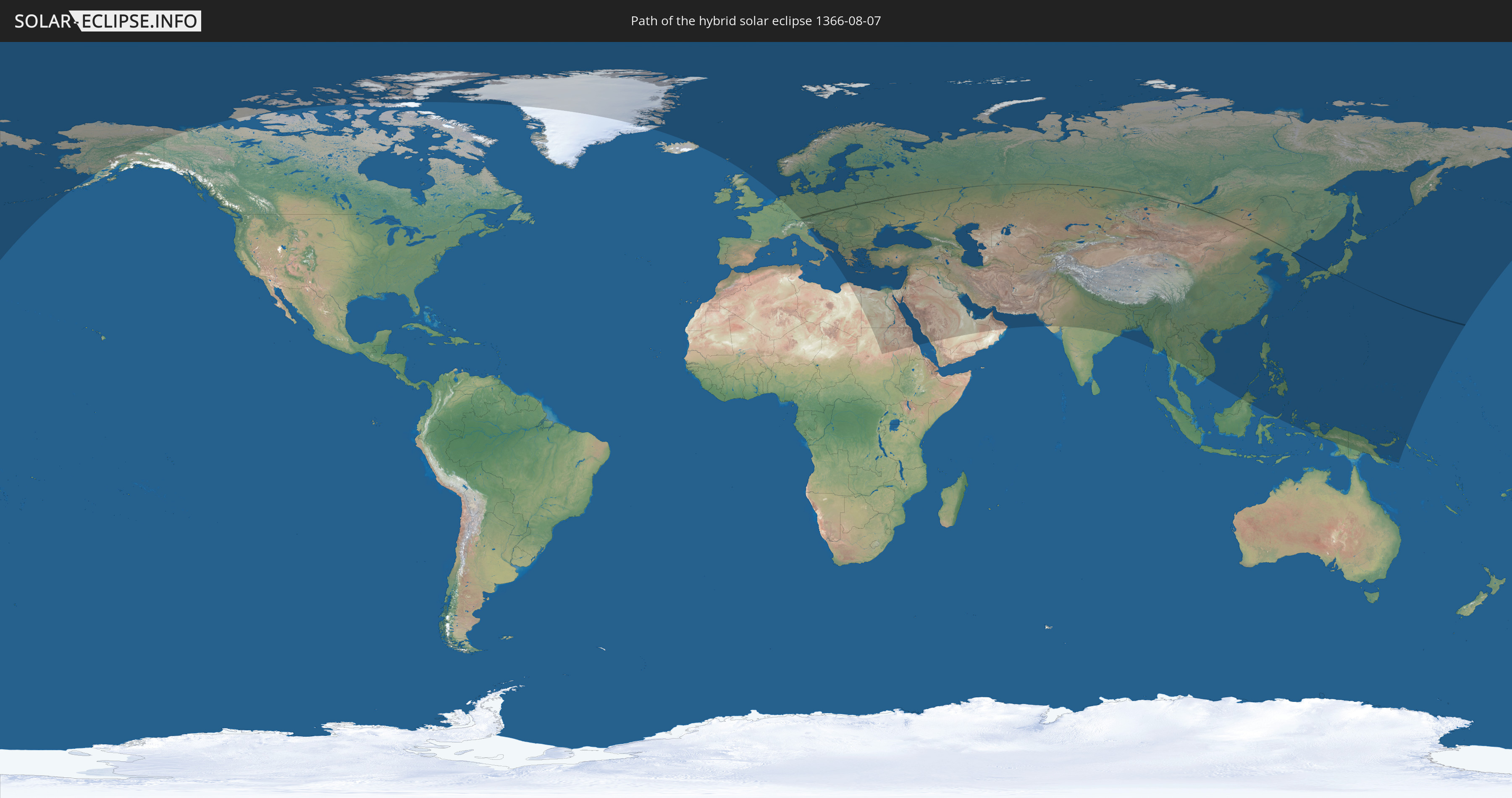
Die Sonnenfinsternis am 08/07/1366 kann man in 93 Ländern als partielle Sonnenfinsternis beobachten.
Der Finsternispfad verläuft durch 11 Länder. Nur in diesen Ländern ist sie als hybrid Sonnenfinsternis zu sehen.
In den folgenden Ländern ist die Sonnenfinsternis hybrid zu sehen
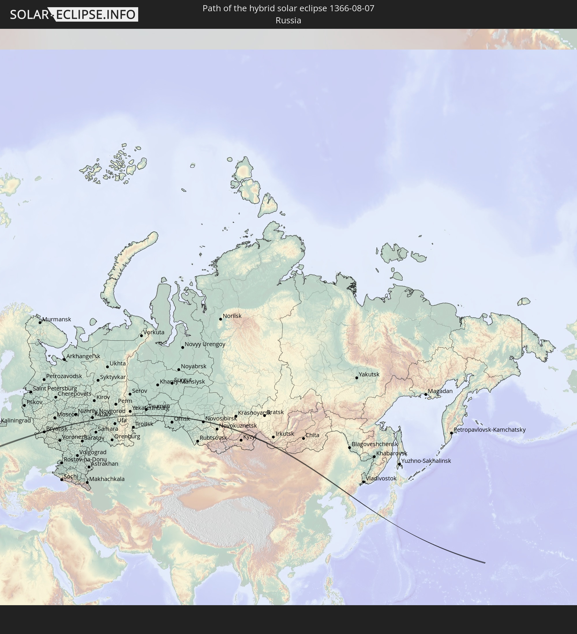 Russia
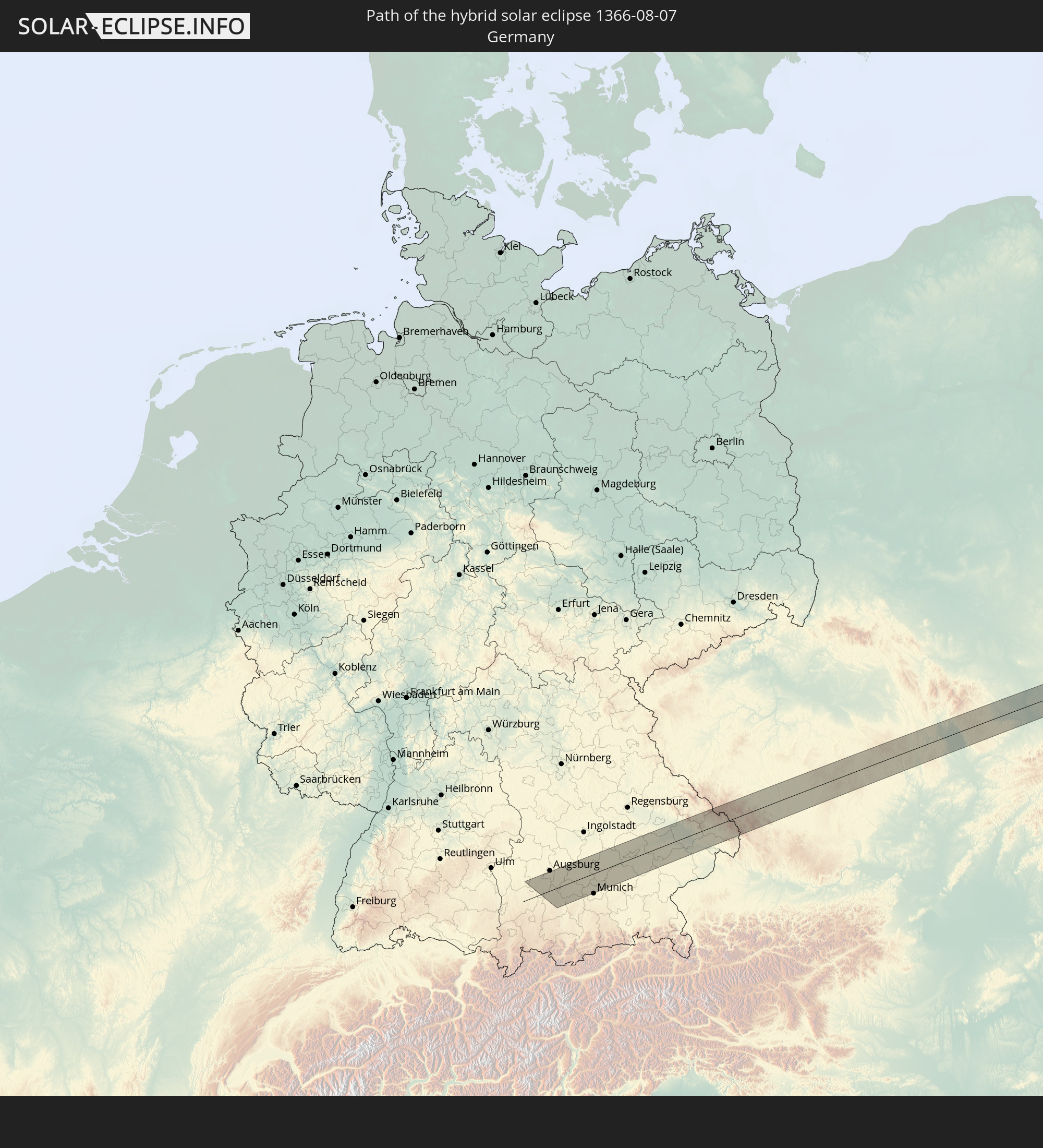 Germany
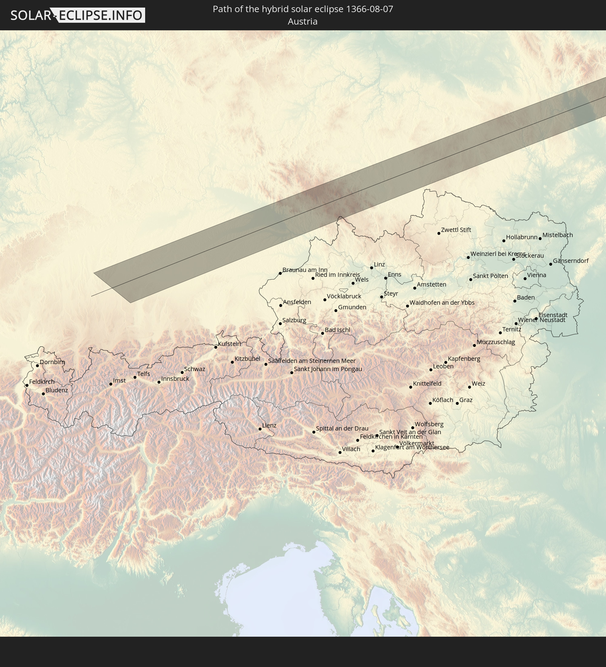 Austria
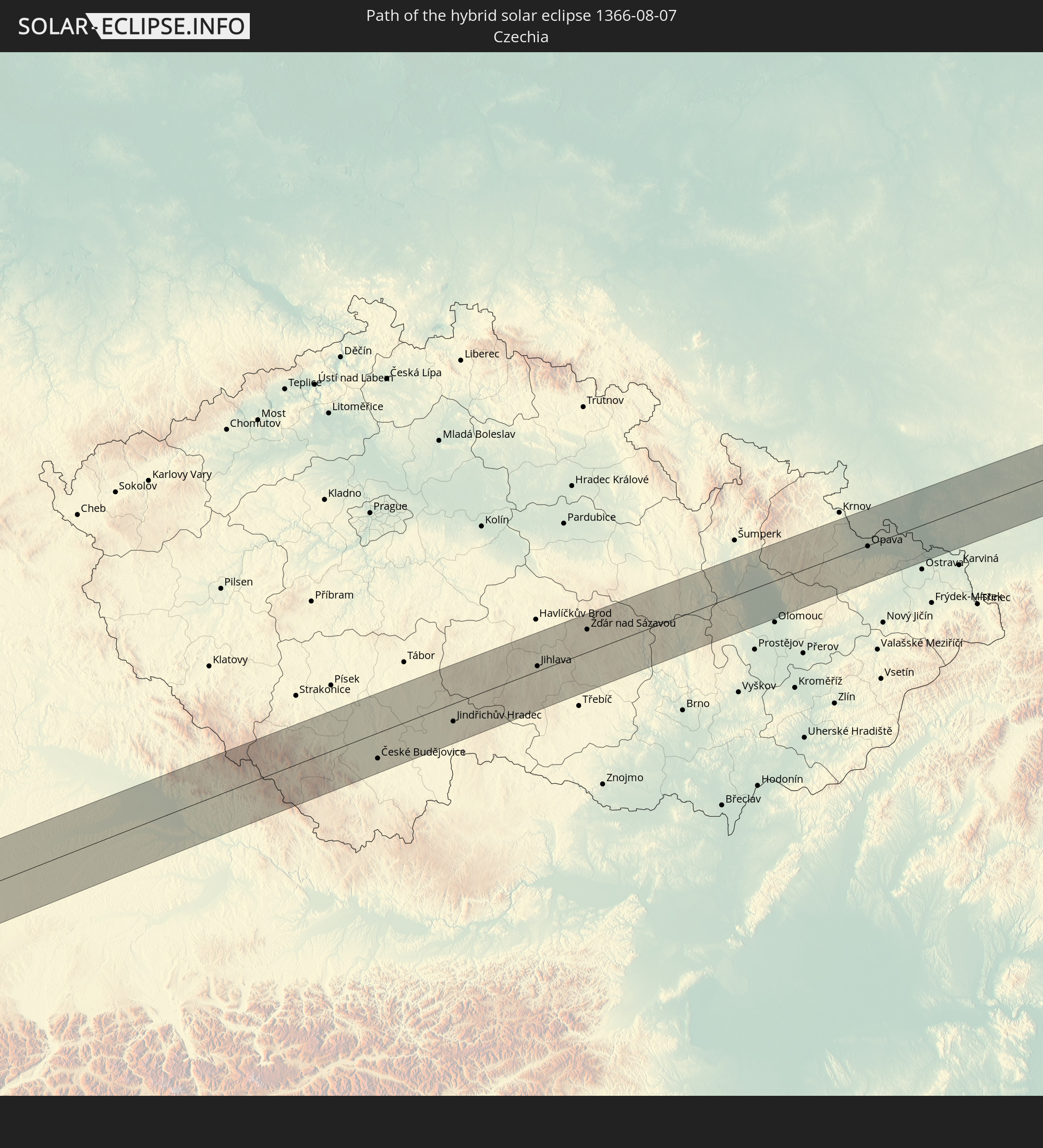 Czechia
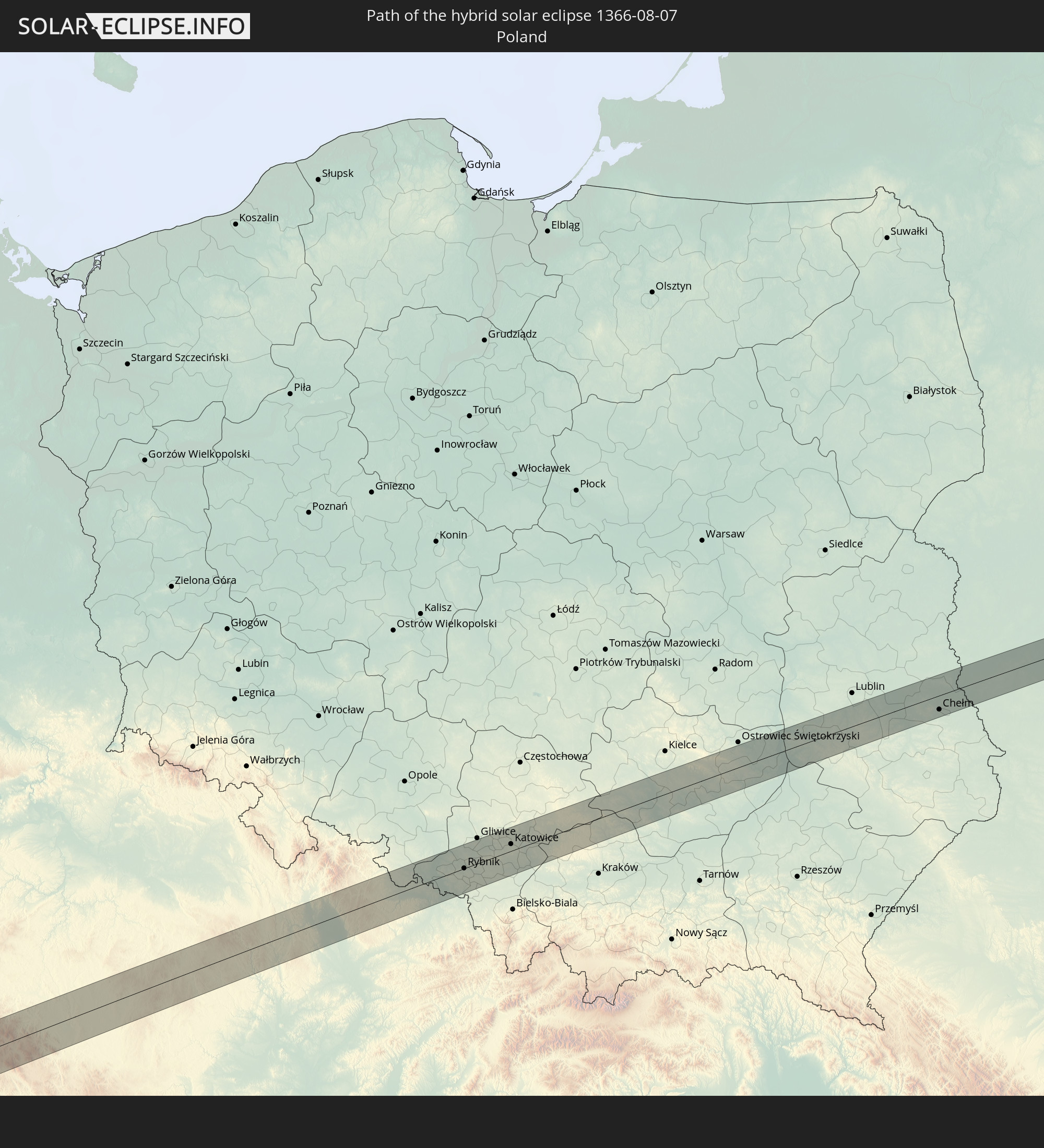 Poland
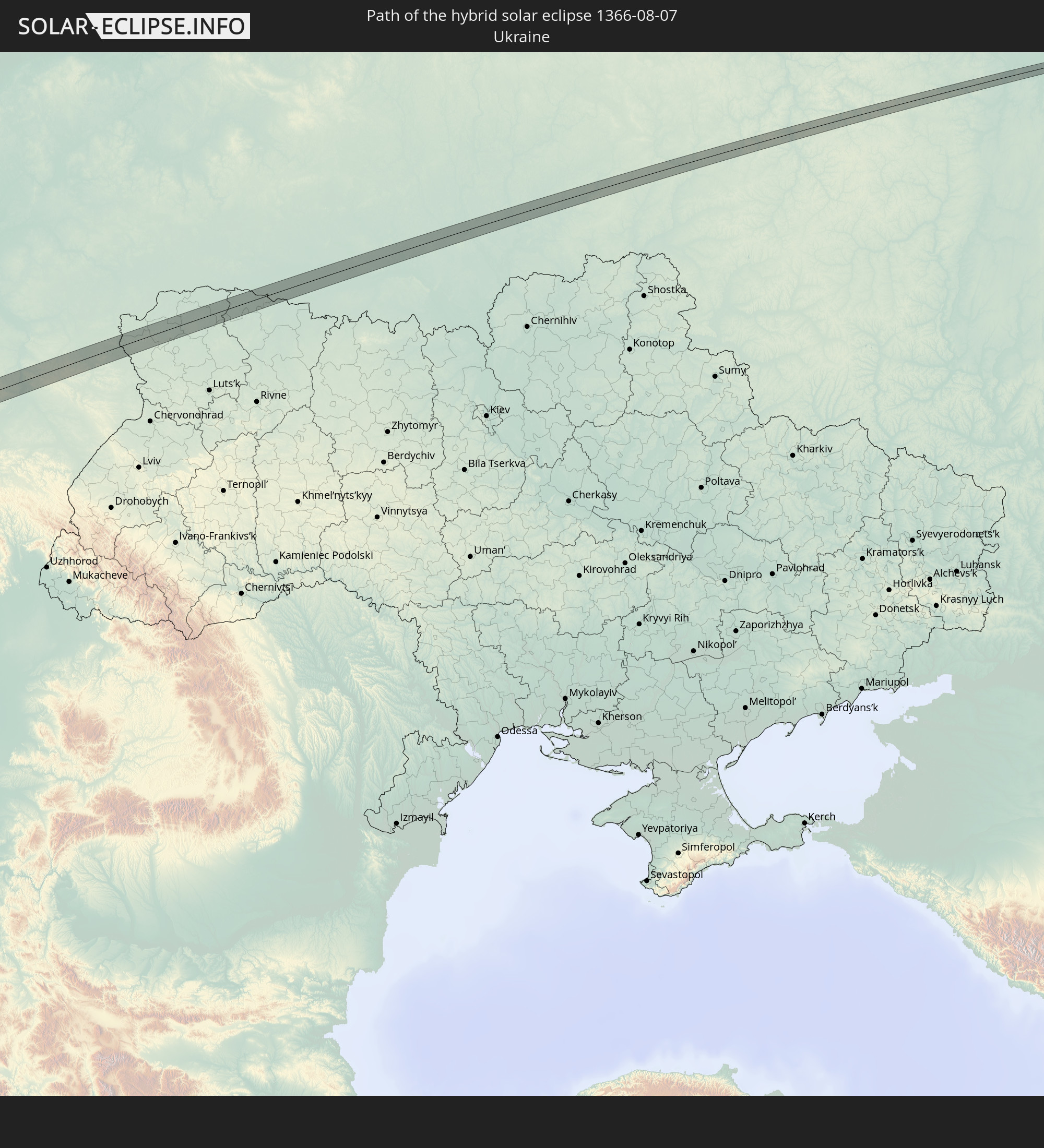 Ukraine
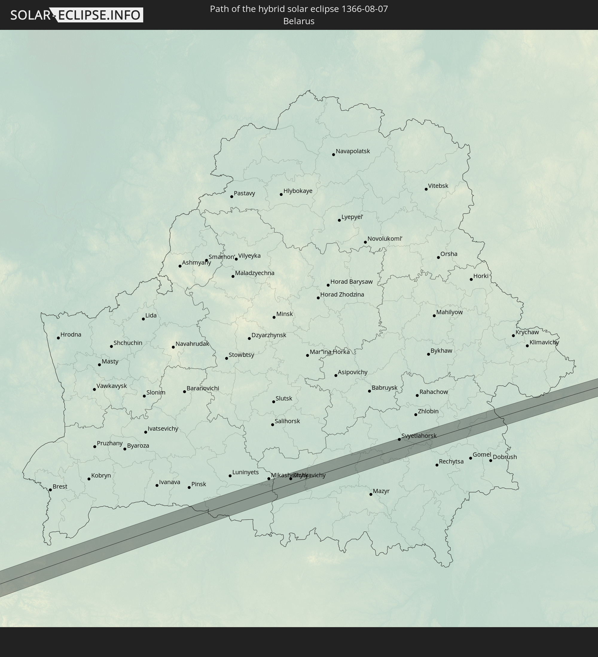 Belarus
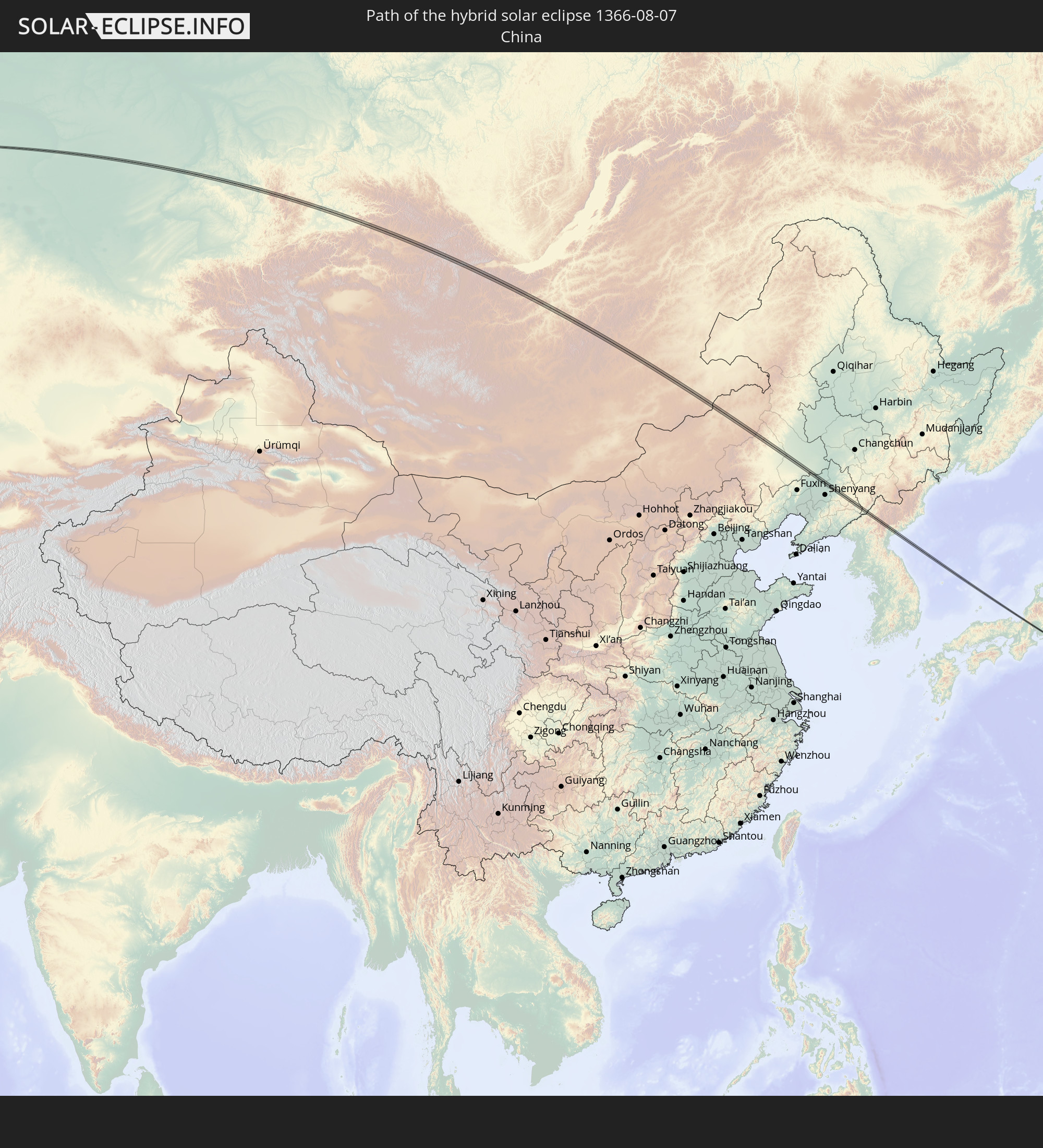 China
China
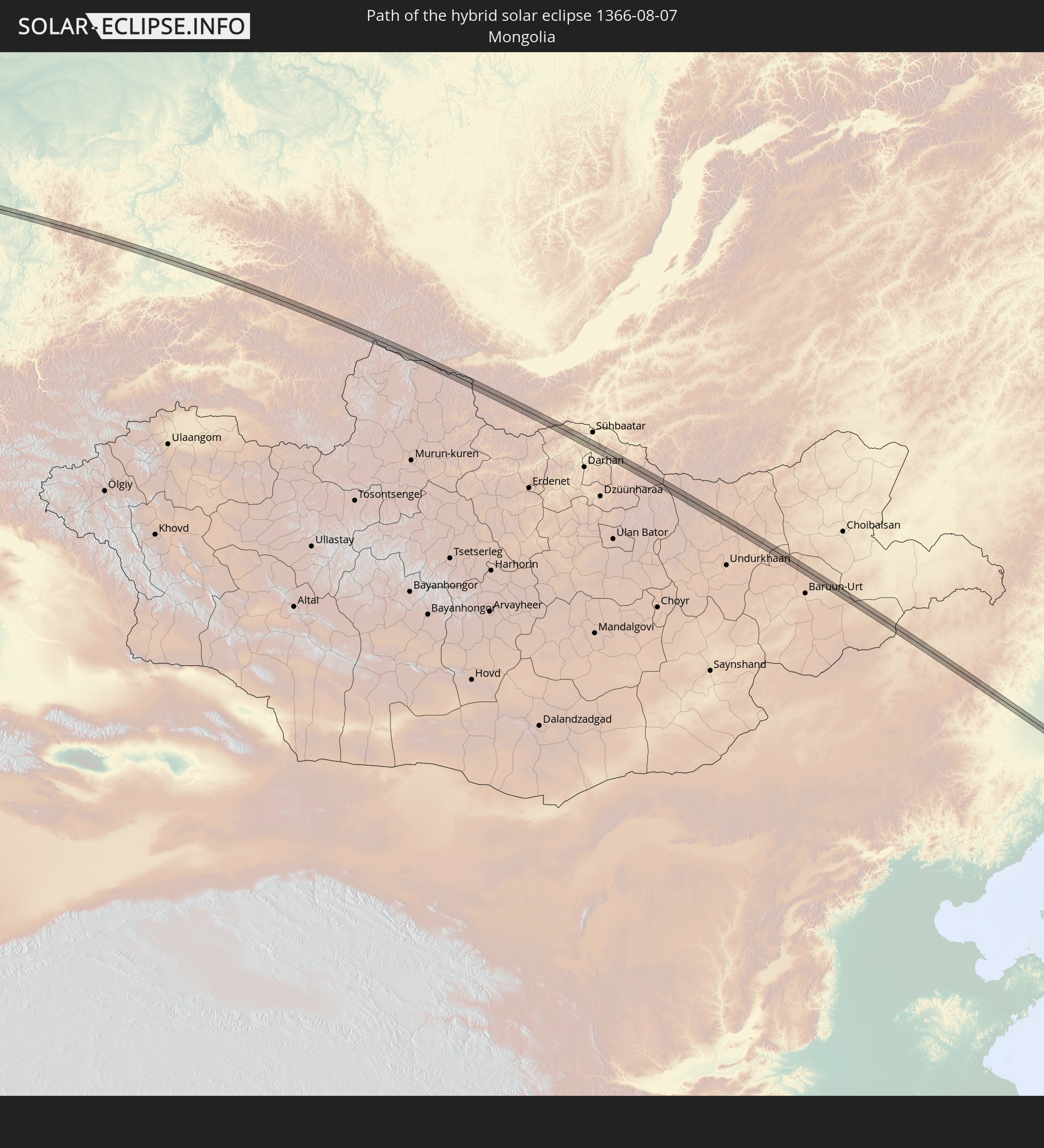 Mongolia
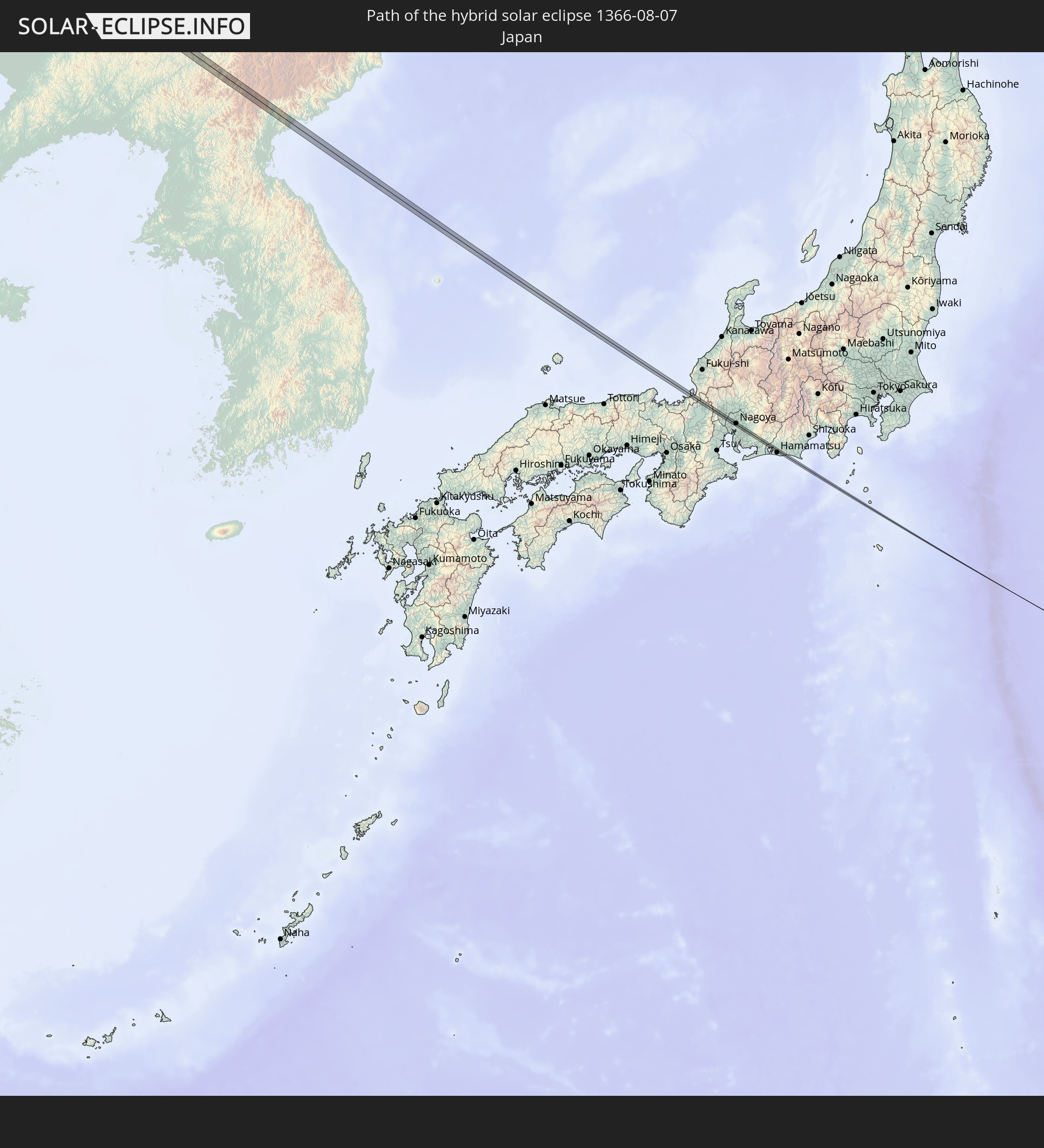 Japan
Japan
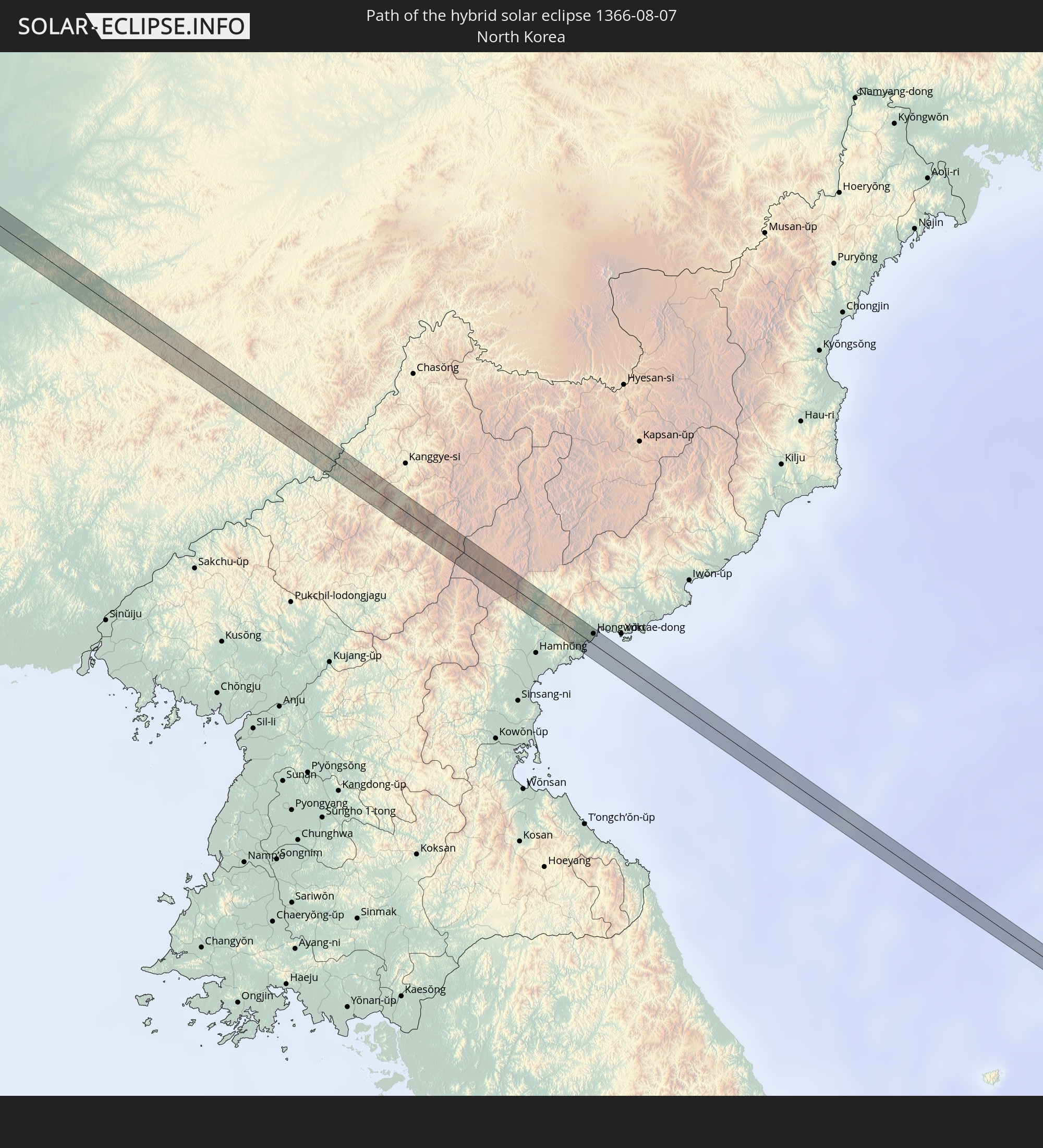 North Korea
In den folgenden Ländern ist die Sonnenfinsternis partiell zu sehen
 Russia
 United States
 United States Minor Outlying Islands
 Canada
 Greenland
 Iceland
 Svalbard and Jan Mayen
 United Kingdom
 Faroe Islands
 Netherlands
 Norway
 Germany
 Italy
Italy
 Denmark
 Libya
Libya
 Austria
 Sweden
 Czechia
 Slovenia
 Croatia
 Poland
 Bosnia and Herzegovina
 Hungary
 Slovakia
 Montenegro
 Serbia
 Albania
 Åland Islands
 Greece
 Romania
 Republic of Macedonia
 Finland
 Lithuania
 Latvia
 Estonia
 Sudan
Sudan
 Ukraine
 Bulgaria
 Belarus
 Egypt
Egypt
 Turkey
 Moldova
 Cyprus
 State of Palestine
 Israel
 Saudi Arabia
 Jordan
 Lebanon
 Syria
Syria
 Eritrea
 Iraq
Iraq
 Georgia
 Armenia
 Iran
Iran
 Azerbaijan
 Kazakhstan
 Kuwait
 Bahrain
 Qatar
Qatar
 United Arab Emirates
 Oman
Oman
 Turkmenistan
 Uzbekistan
 Afghanistan
 Pakistan
 Tajikistan
 India
India
 Kyrgyzstan
 China
China
 Nepal
Nepal
 Mongolia
 Bangladesh
 Bhutan
 Myanmar
 Indonesia
 Thailand
 Malaysia
 Laos
Laos
 Vietnam
 Cambodia
 Macau
Macau
 Hong Kong
 Taiwan
 Philippines
 Japan
Japan
 North Korea
 South Korea
 Palau
Palau
 Federated States of Micronesia
 Papua New Guinea
 Guam
Guam
 Northern Mariana Islands
 Marshall Islands
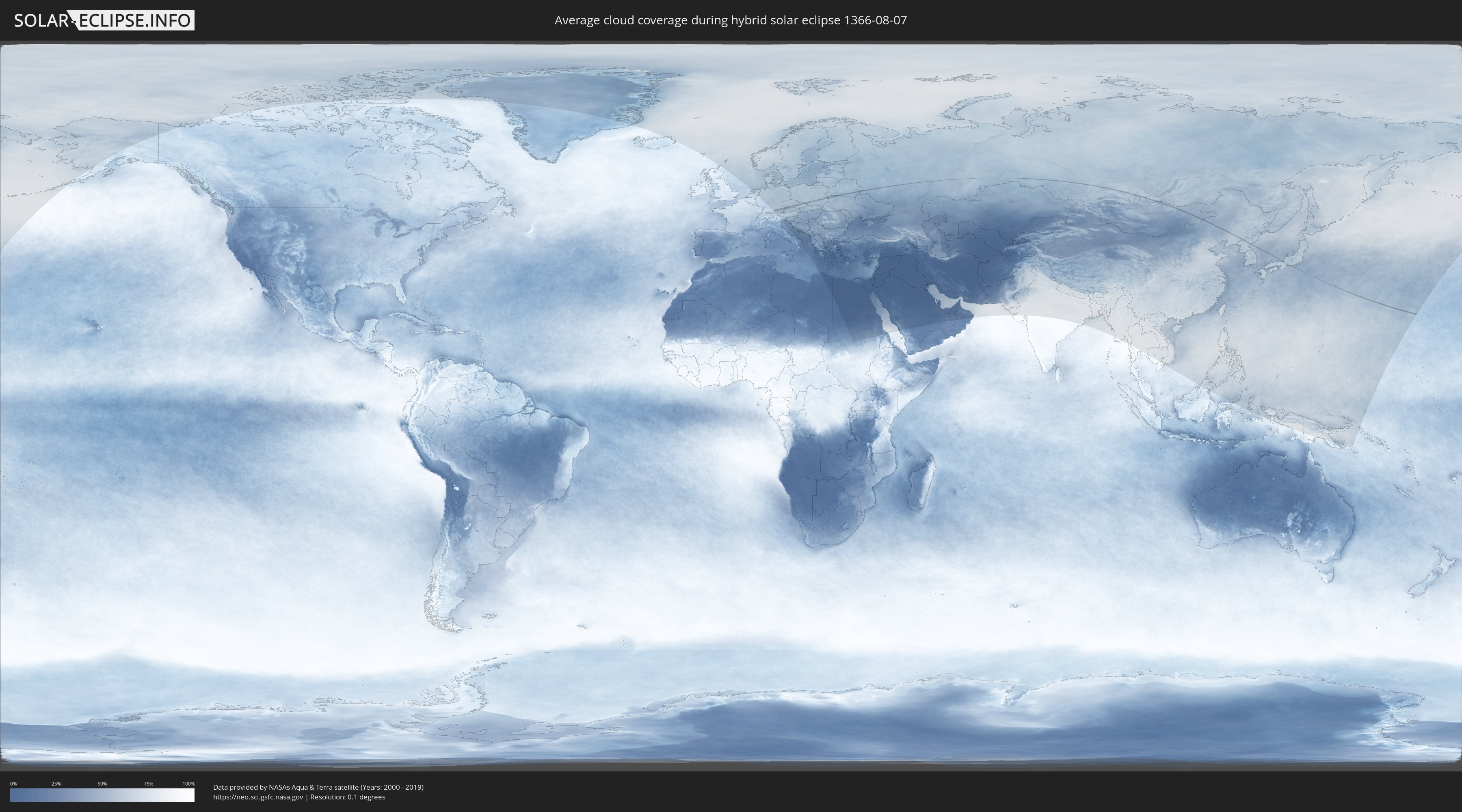
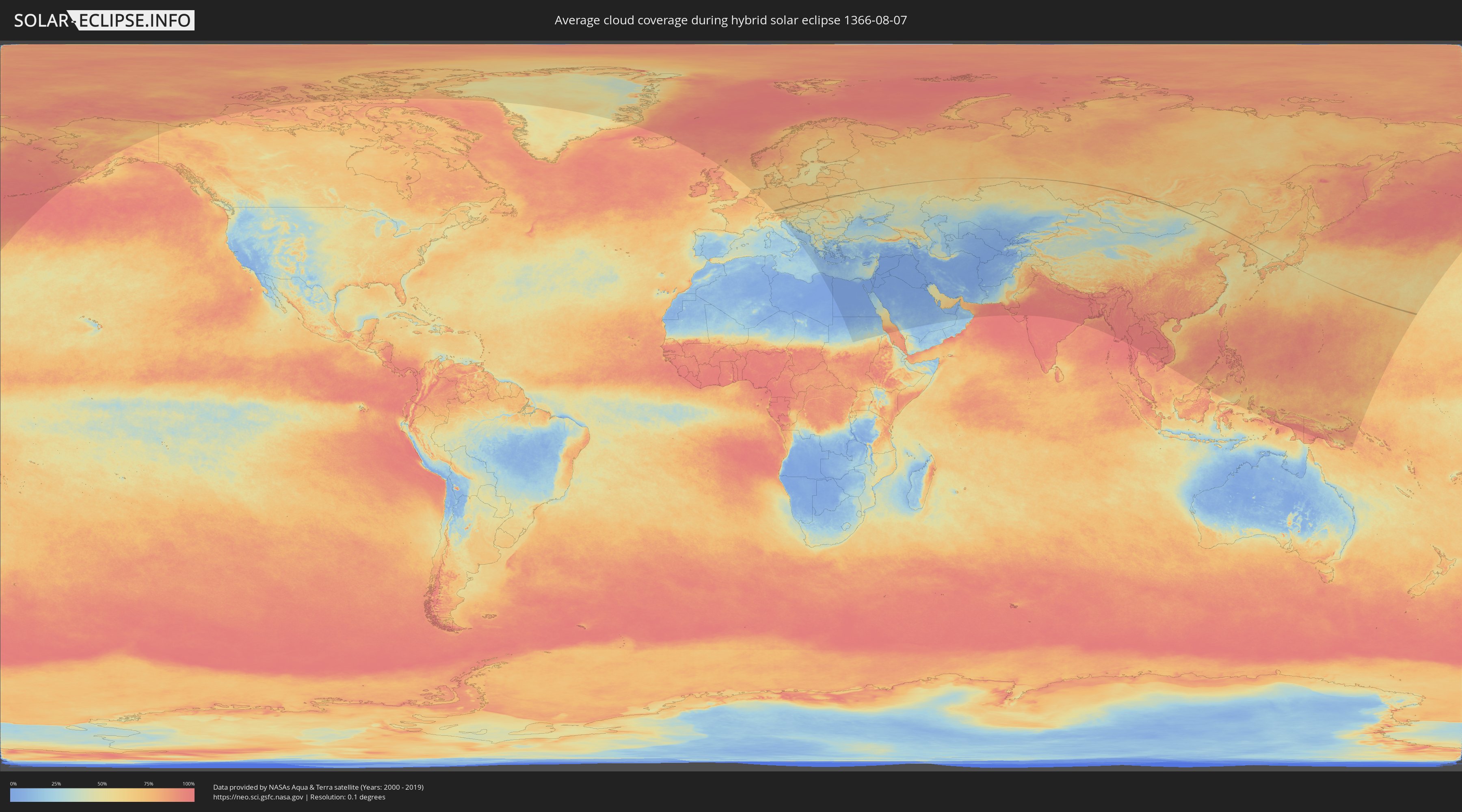
How will be the weather during the hybrid solar eclipse on 08/07/1366?
Where is the best place to see the hybrid solar eclipse of 08/07/1366?
The following maps show the average cloud coverage for the day of the hybrid solar eclipse.
With the help of these maps, it is possible to find the place along the eclipse path, which has the best
chance of a cloudless sky.
Nevertheless, you should consider local circumstances and inform about the weather of your chosen
observation site.
The data is provided by NASAs satellites
AQUA and TERRA.
The cloud maps are averaged over a period of 19 years (2000 - 2019).
Detailed country maps
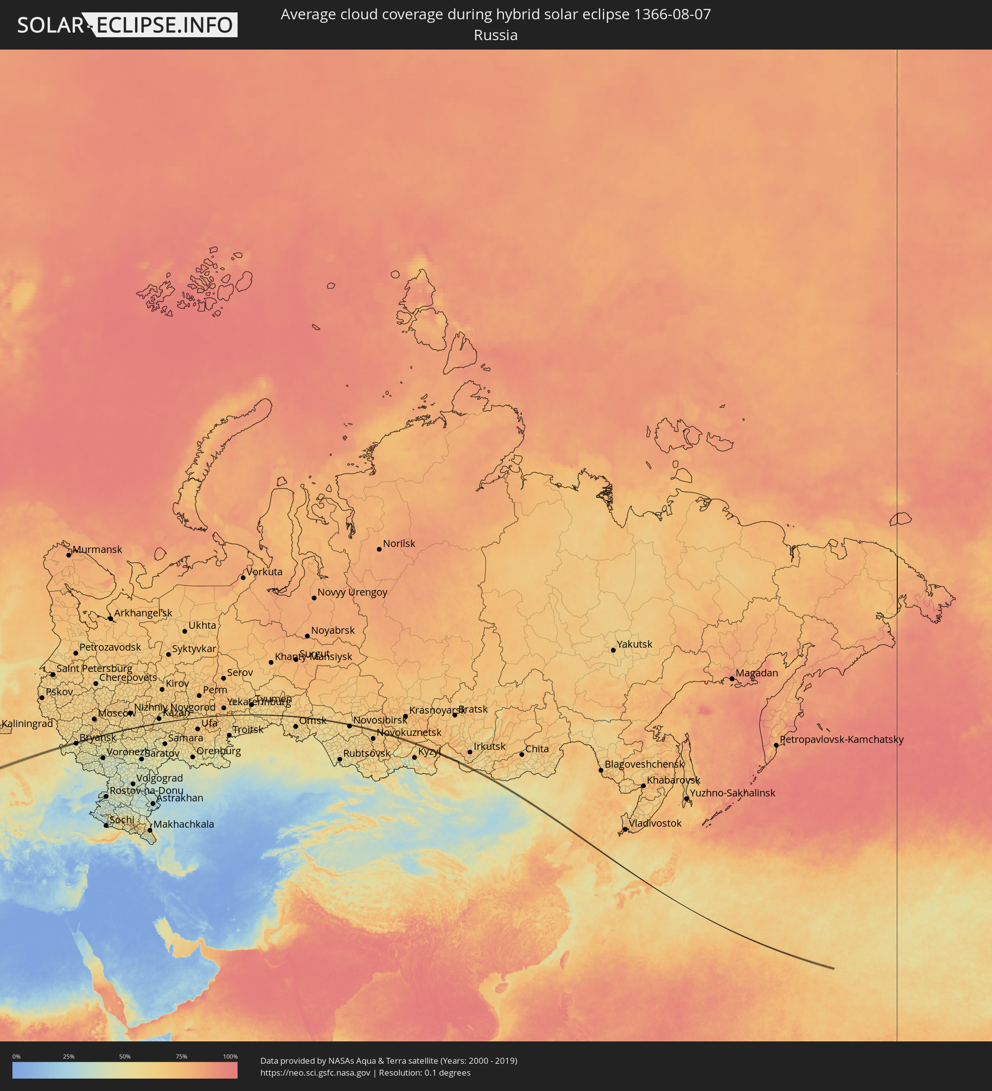 Russia
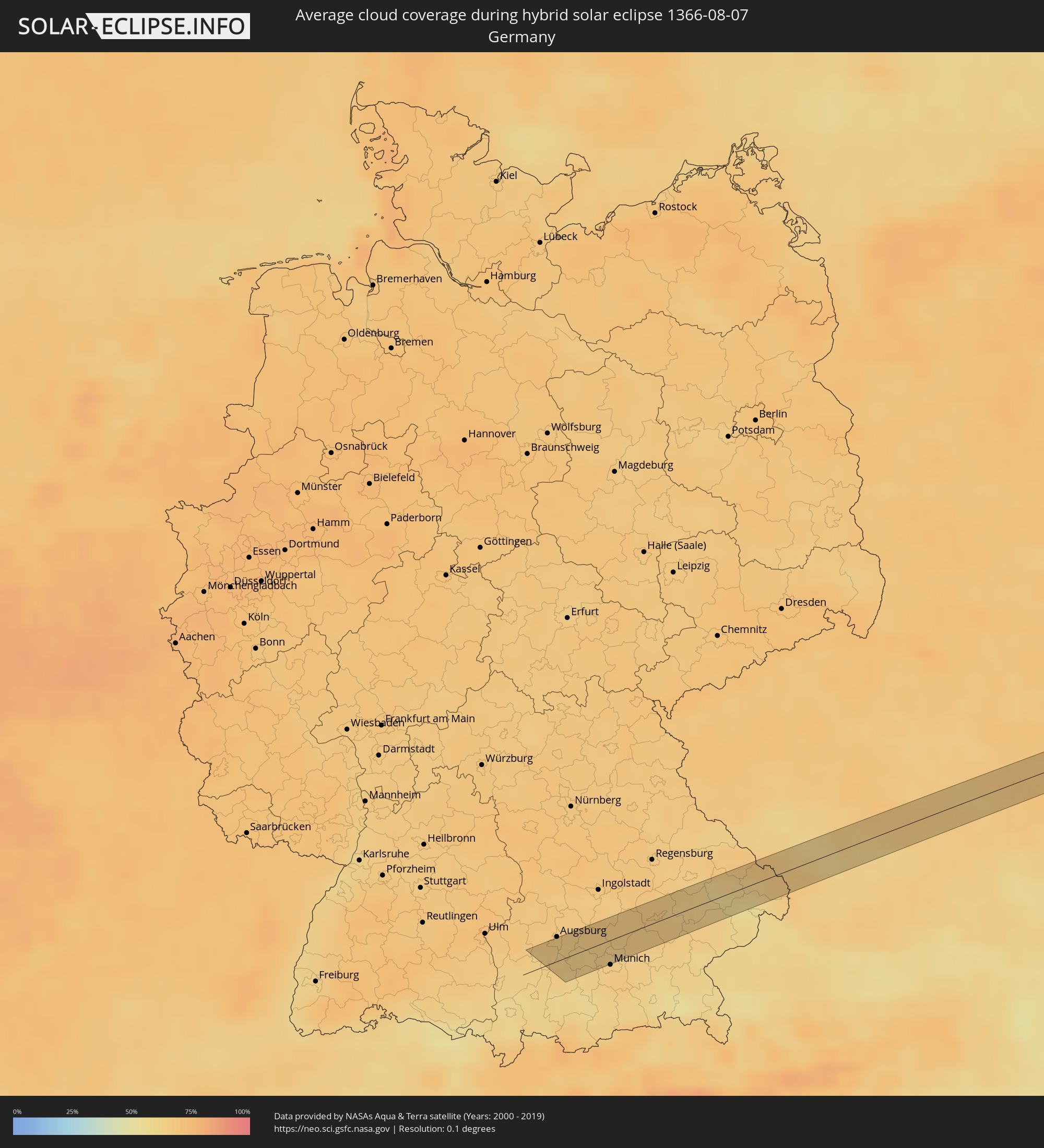 Germany
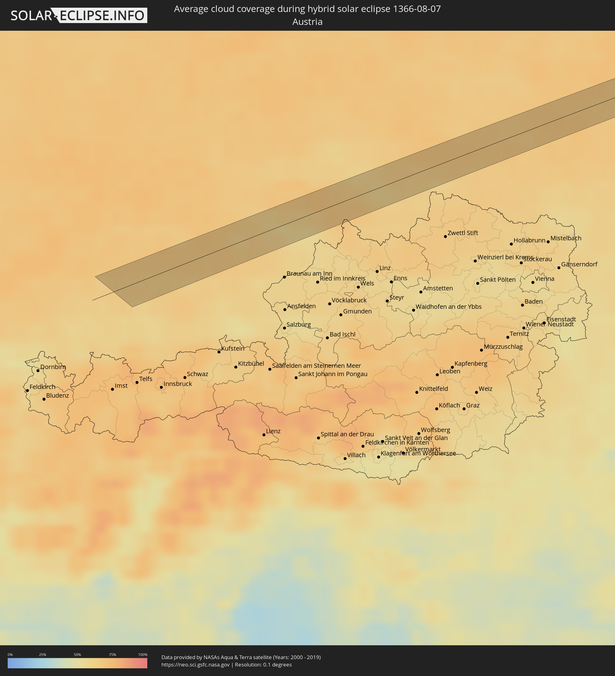 Austria
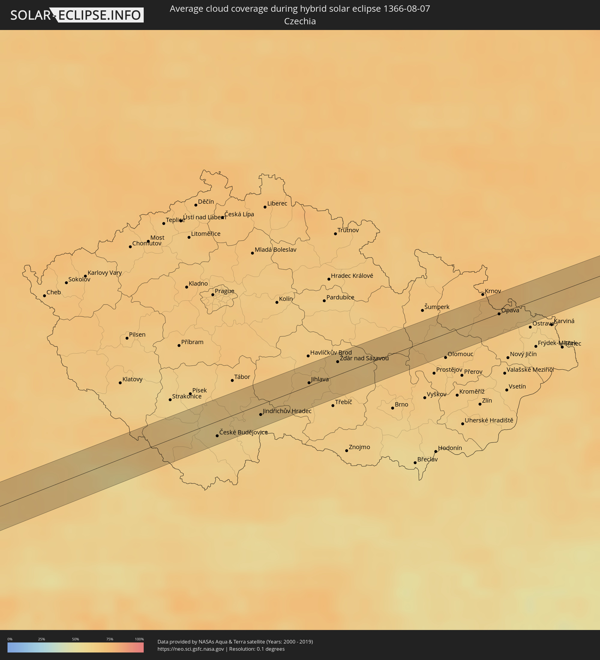 Czechia
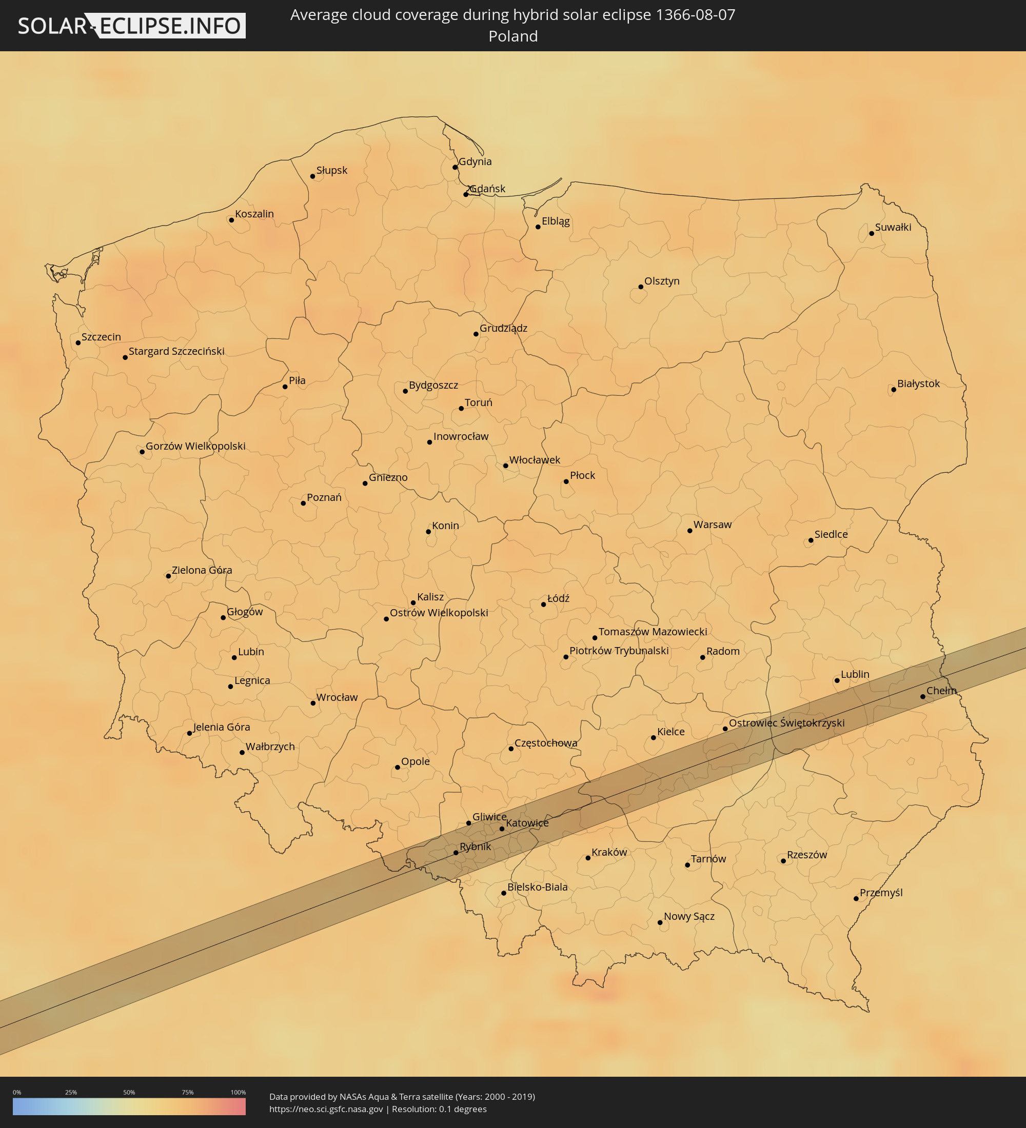 Poland
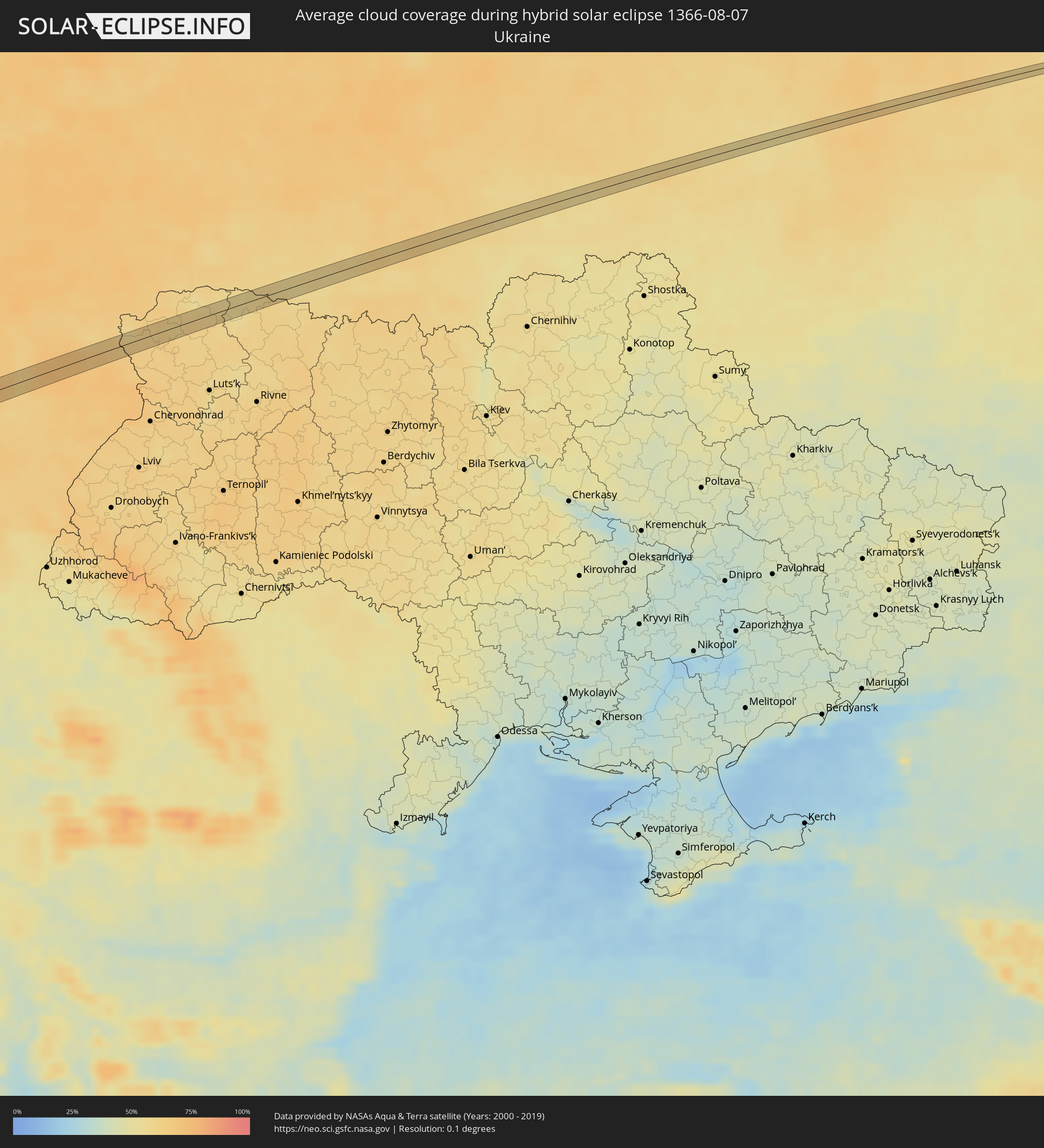 Ukraine
 Belarus
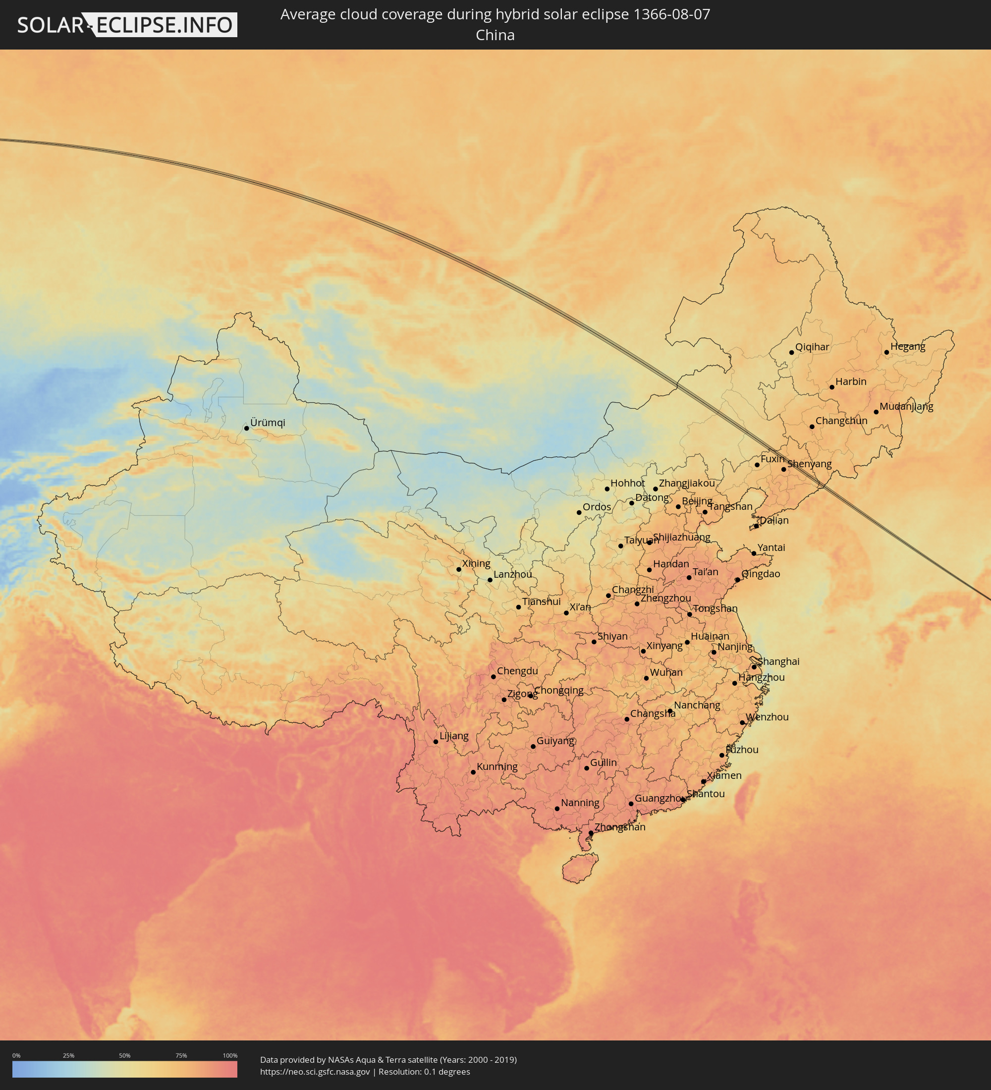 China
China
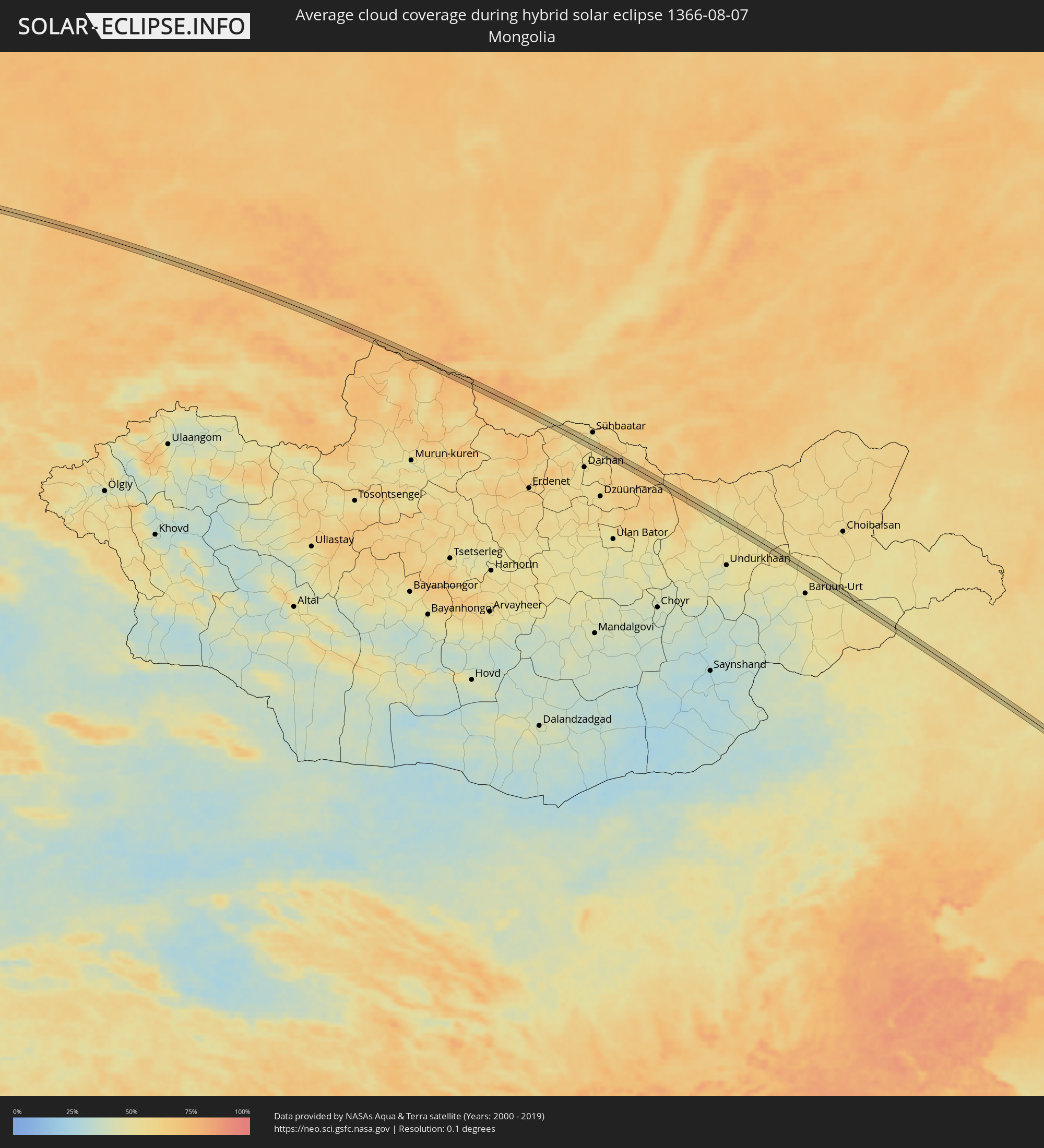 Mongolia
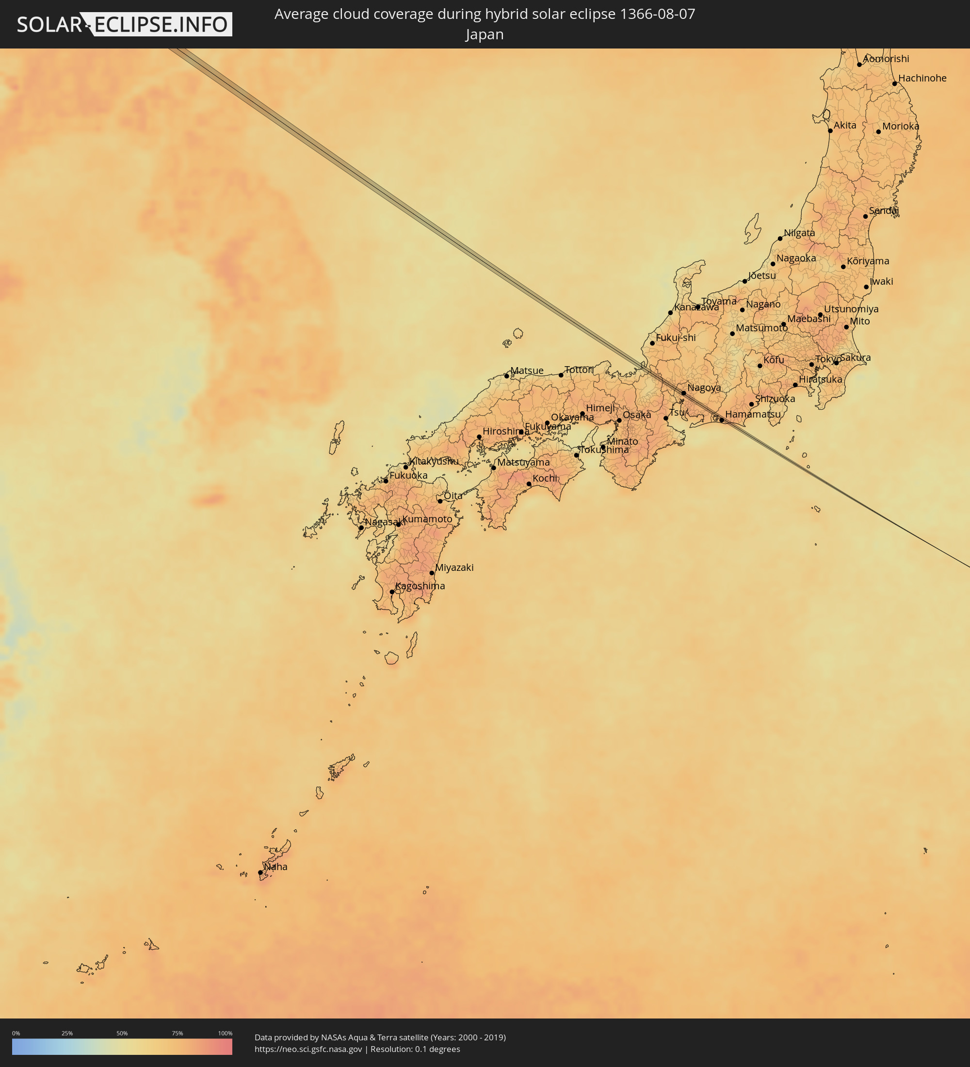 Japan
Japan
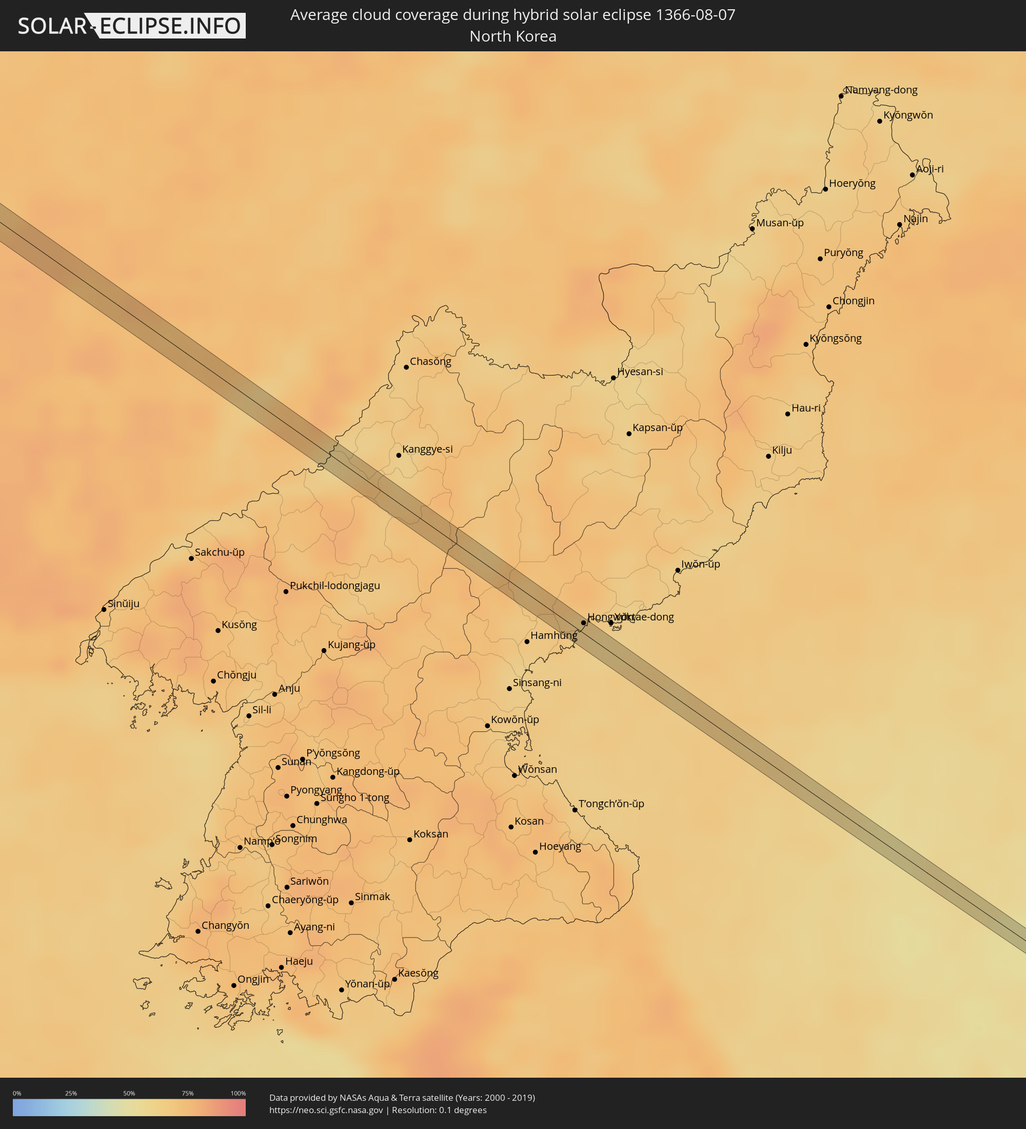 North Korea
Cities inside the path of the eclipse
The following table shows all locations with a population of more than 5,000 inside the eclipse path. Cities which have more than 100,000 inhabitants are marked bold. A click at the locations opens a detailed map.
| City | Type | Eclipse duration | Local time of max. eclipse | Distance to central line | Ø Cloud coverage |
|
Schwabmünchen, Bavaria
|
annular | - | 05:16:08 UTC+01:00 | 5 km | 65% |
|
Untermeitingen, Bavaria
|
annular | - | 05:16:06 UTC+01:00 | 2 km | 65% |
|
Friedberg, Bavaria
|
annular | - | 05:16:16 UTC+01:00 | 17 km | 65% |
|
Fürstenfeldbruck, Bavaria
|
annular | - | 05:15:59 UTC+01:00 | 8 km | 63% |
|
Altomünster, Bavaria
|
annular | - | 05:16:13 UTC+01:00 | 13 km | 65% |
|
Dachau, Bavaria
|
annular | - | 05:16:02 UTC+01:00 | 5 km | 64% |
|
Garching bei München, Bavaria
|
annular | - | 05:15:58 UTC+01:00 | 12 km | 65% |
|
Freising, Bavaria
|
annular | - | 05:16:06 UTC+01:00 | 1 km | 65% |
|
Erding, Bavaria
|
annular | - | 05:15:57 UTC+01:00 | 13 km | 63% |
|
Moosburg, Bavaria
|
annular | - | 05:16:08 UTC+01:00 | 3 km | 67% |
|
Taufkirchen, Bavaria
|
annular | - | 05:15:57 UTC+01:00 | 15 km | 62% |
|
Landshut, Bavaria
|
annular | - | 05:16:08 UTC+01:00 | 3 km | 67% |
|
Ergoldsbach, Bavaria
|
annular | - | 05:16:19 UTC+01:00 | 19 km | 66% |
|
Velden, Bavaria
|
annular | - | 05:15:56 UTC+01:00 | 16 km | 65% |
|
Vilsbiburg, Bavaria
|
annular | - | 05:16:00 UTC+01:00 | 10 km | 65% |
|
Dingolfing, Bavaria
|
annular | - | 05:16:11 UTC+01:00 | 6 km | 65% |
|
Gangkofen, Bavaria
|
annular | - | 05:15:56 UTC+01:00 | 17 km | 63% |
|
Landau an der Isar, Bavaria
|
annular | - | 05:16:10 UTC+01:00 | 4 km | 63% |
|
Arnstorf, Bavaria
|
annular | - | 05:16:00 UTC+01:00 | 11 km | 63% |
|
Deggendorf, Bavaria
|
annular | - | 05:16:18 UTC+01:00 | 14 km | 56% |
|
Vilshofen, Bavaria
|
annular | - | 05:16:00 UTC+01:00 | 14 km | 58% |
|
Grafenau, Bavaria
|
annular | - | 05:16:13 UTC+01:00 | 4 km | 63% |
|
Waldkirchen, Bavaria
|
annular | - | 05:16:01 UTC+01:00 | 14 km | 60% |
|
Vimperk, Jihočeský
|
annular | - | 05:16:22 UTC+01:00 | 15 km | 65% |
|
Prachatice, Jihočeský
|
annular | - | 05:16:15 UTC+01:00 | 4 km | 67% |
|
Týn nad Vltavou, Jihočeský
|
annular | - | 05:16:25 UTC+01:00 | 15 km | 61% |
|
České Budějovice, Jihočeský
|
annular | - | 05:16:07 UTC+01:00 | 12 km | 61% |
|
Třeboň, Jihočeský
|
annular | - | 05:16:05 UTC+01:00 | 17 km | 60% |
|
Jindřichův Hradec, Jihočeský
|
annular | - | 05:16:12 UTC+01:00 | 9 km | 61% |
|
Pelhřimov, Vysočina
|
annular | - | 05:16:30 UTC+01:00 | 16 km | 67% |
|
Jihlava, Vysočina
|
annular | - | 05:16:23 UTC+01:00 | 2 km | 66% |
|
Žďár nad Sázavou, Vysočina
|
annular | - | 05:16:31 UTC+01:00 | 11 km | 65% |
|
Velké Meziříčí, Vysočina
|
annular | - | 05:16:15 UTC+01:00 | 13 km | 66% |
|
Nové Město na Moravě, Vysočina
|
annular | - | 05:16:30 UTC+01:00 | 7 km | 65% |
|
Bystřice nad Pernštejnem, Vysočina
|
annular | - | 05:16:25 UTC+01:00 | 2 km | 65% |
|
Polička, Pardubický
|
annular | - | 05:16:39 UTC+01:00 | 18 km | 66% |
|
Svitavy, Pardubický
|
annular | - | 05:16:40 UTC+01:00 | 17 km | 68% |
|
Boskovice, South Moravian
|
annular | - | 05:16:18 UTC+01:00 | 16 km | 67% |
|
Moravská Třebová, Pardubický
|
annular | - | 05:16:38 UTC+01:00 | 12 km | 68% |
|
Mohelnice, Olomoucký
|
annular | - | 05:16:37 UTC+01:00 | 8 km | 67% |
|
Litovel, Olomoucký
|
annular | - | 05:16:30 UTC+01:00 | 4 km | 67% |
|
Rýmařov
|
annular | - | 05:16:45 UTC+01:00 | 15 km | 66% |
|
Šternberk, Olomoucký
|
annular | - | 05:16:30 UTC+01:00 | 7 km | 66% |
|
Bruntál, Moravskoslezský
|
annular | - | 05:16:47 UTC+01:00 | 16 km | 67% |
|
Opava, Moravskoslezský
|
annular | - | 05:16:40 UTC+01:00 | 0 km | 68% |
|
Racibórz, Silesian Voivodeship
|
annular | - | 05:40:48 UTC+01:24 | 8 km | 69% |
|
Bohumín, Moravskoslezský
|
annular | - | 05:16:34 UTC+01:00 | 15 km | 62% |
|
Pszów, Silesian Voivodeship
|
annular | - | 05:40:43 UTC+01:24 | 2 km | 63% |
|
Niedobczyce, Silesian Voivodeship
|
annular | - | 05:40:44 UTC+01:24 | 2 km | 66% |
|
Rybnik, Silesian Voivodeship
|
annular | - | 05:40:46 UTC+01:24 | 0 km | 66% |
|
Jastrzębie Zdrój, Silesian Voivodeship
|
annular | - | 05:40:36 UTC+01:24 | 16 km | 68% |
|
Knurów, Silesian Voivodeship
|
annular | - | 05:40:55 UTC+01:24 | 10 km | 68% |
|
Łaziska Górne, Silesian Voivodeship
|
annular | - | 05:40:48 UTC+01:24 | 2 km | 66% |
|
Katowice, Silesian Voivodeship
|
annular | - | 05:40:55 UTC+01:24 | 5 km | 68% |
|
Wojkowice, Silesian Voivodeship
|
annular | - | 05:41:03 UTC+01:24 | 16 km | 69% |
|
Bieruń, Silesian Voivodeship
|
annular | - | 05:40:42 UTC+01:24 | 14 km | 64% |
|
Lędziny, Silesian Voivodeship
|
annular | - | 05:40:46 UTC+01:24 | 10 km | 64% |
|
Imielin, Silesian Voivodeship
|
annular | - | 05:40:45 UTC+01:24 | 11 km | 64% |
|
Dąbrowa Górnicza, Silesian Voivodeship
|
annular | - | 05:40:58 UTC+01:24 | 6 km | 68% |
|
Łazy, Silesian Voivodeship
|
annular | - | 05:41:05 UTC+01:24 | 13 km | 68% |
|
Bukowno, Lesser Poland Voivodeship
|
annular | - | 05:40:53 UTC+01:24 | 5 km | 69% |
|
Olkusz, Lesser Poland Voivodeship
|
annular | - | 05:40:53 UTC+01:24 | 6 km | 68% |
|
Wolbrom, Lesser Poland Voivodeship
|
annular | - | 05:40:59 UTC+01:24 | 1 km | 74% |
|
Miechów, Lesser Poland Voivodeship
|
annular | - | 05:40:56 UTC+01:24 | 10 km | 73% |
|
Jędrzejów, Świętokrzyskie
|
annular | - | 05:41:16 UTC+01:24 | 13 km | 75% |
|
Pińczów, Świętokrzyskie
|
annular | - | 05:41:06 UTC+01:24 | 5 km | 71% |
|
Busko-Zdrój, Świętokrzyskie
|
annular | - | 05:41:01 UTC+01:24 | 15 km | 70% |
|
Kraśnik, Lublin Voivodeship
|
annular | - | 05:41:30 UTC+01:24 | 3 km | 69% |
|
Chełm, Lublin Voivodeship
|
annular | - | 05:41:45 UTC+01:24 | 10 km | 70% |
|
Lyuboml’, Volyn
|
annular | - | 06:19:55 UTC+02:02 | 14 km | 64% |
|
Stara Vyzhivka, Volyn
|
annular | - | 06:20:12 UTC+02:02 | 1 km | 63% |
|
Kamin’-Kashyrs’kyy, Volyn
|
annular | - | 06:20:27 UTC+02:02 | 7 km | 62% |
|
Kuznetsovs’k, Rivne
|
annular | - | 06:20:33 UTC+02:02 | 7 km | 54% |
|
Zarichne, Rivne
|
annular | - | 06:20:44 UTC+02:02 | 0 km | 57% |
|
Stolin, Brest
|
annular | - | 06:08:49 UTC+01:50 | 7 km | 60% |
|
Davyd-Haradok, Brest
|
annular | - | 06:09:03 UTC+01:50 | 2 km | 57% |
|
Zhytkavichy, Gomel
|
annular | - | 06:09:19 UTC+01:50 | 5 km | 58% |
|
Svyetlahorsk, Gomel
|
annular | - | 06:10:05 UTC+01:50 | 10 km | 60% |
|
Surazh, Brjansk
|
annular | - | 06:51:19 UTC+02:30 | 2 km | 55% |
|
Mglin, Brjansk
|
annular | - | 06:51:28 UTC+02:30 | 7 km | 56% |
|
Sel’tso, Brjansk
|
annular | - | 06:52:10 UTC+02:30 | 2 km | 59% |
|
Borodinskiy, Tula
|
annular | - | 06:54:03 UTC+02:30 | 4 km | 64% |
|
Kireyevsk, Tula
|
annular | - | 06:54:00 UTC+02:30 | 5 km | 66% |
|
Dubovka, Tula
|
annular | - | 06:54:04 UTC+02:30 | 5 km | 65% |
|
Uzlovaya, Tula
|
annular | - | 06:54:09 UTC+02:30 | 4 km | 65% |
|
Novomoskovsk, Tula
|
annular | - | 06:54:14 UTC+02:30 | 2 km | 63% |
|
Donskoy, Tula
|
annular | - | 06:54:11 UTC+02:30 | 8 km | 63% |
|
Severo-Zadonsk, Tula
|
annular | - | 06:54:18 UTC+02:30 | 2 km | 62% |
|
Starozhilovo, Rjazan
|
annular | - | 06:55:06 UTC+02:30 | 6 km | 60% |
|
Spassk-Ryazanskiy, Rjazan
|
annular | - | 06:55:31 UTC+02:30 | 6 km | 58% |
|
Bol’shoye Boldino, Nizjnij Novgorod
|
annular | - | 06:58:32 UTC+02:30 | 2 km | 63% |
|
Nizhnekamsk, Tatarstan
|
annular | - | 07:03:09 UTC+02:30 | 1 km | 66% |
|
Menzelinsk, Tatarstan
|
annular | - | 07:04:07 UTC+02:30 | 2 km | 63% |
|
Kolyvan’, Novosibirsk
|
total | - | 11:15:58 UTC+06:11 | 6 km | 67% |
|
Sokur, Novosibirsk
|
total | - | 11:16:44 UTC+06:11 | 3 km | 67% |
|
Gornyy, Novosibirsk
|
total | - | 11:17:31 UTC+06:11 | 1 km | 67% |
|
Promyshlennaya, Kemerovo
|
total | - | 11:19:53 UTC+06:11 | 4 km | 70% |
|
Ust’-Abakan, Khakasiya
|
total | - | 11:28:16 UTC+06:11 | 8 km | 63% |
|
Karatuzskoye, Krasnoyarskiy
|
total | - | 11:30:33 UTC+06:11 | 1 km | 67% |
|
Huanren, Liaoning
|
total | - | 14:24:05 UTC+08:00 | 8 km | 64% |
|
Samho-rodongjagu, Hamgyŏng-namdo
|
total | - | 14:52:29 UTC+08:23 | 6 km | 63% |
|
Hongwŏn, Hamgyŏng-namdo
|
total | - | 14:52:26 UTC+08:23 | 5 km | 62% |
|
Tsuruga, Fukui
|
total | - | 15:45:31 UTC+09:00 | 3 km | 66% |
|
Tarui, Gifu
|
total | - | 15:46:24 UTC+09:00 | 0 km | 76% |
|
Ōgaki, Gifu
|
total | - | 15:46:30 UTC+09:00 | 3 km | 74% |
|
Sobue, Aichi
|
total | - | 15:46:46 UTC+09:00 | 2 km | 68% |
|
Inazawa, Aichi
|
total | - | 15:46:49 UTC+09:00 | 2 km | 75% |
|
Nagoya, Aichi
|
total | - | 15:47:02 UTC+09:00 | 1 km | 76% |
|
Iwata, Shizuoka
|
total | - | 15:48:38 UTC+09:00 | 2 km | 65% |