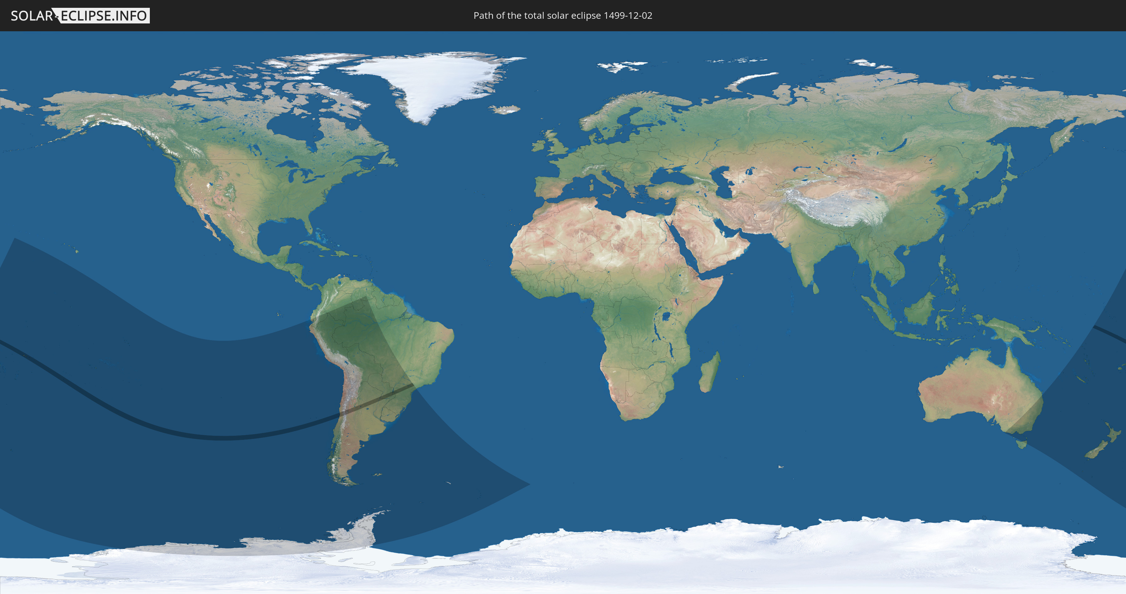
Total solar eclipse of 12/02/1499
| Day of week: | Saturday |
| Maximum duration of eclipse: | 03m51s |
| Maximum width of eclipse path: | 162 km |
| Saros cycle: | 124 |
| Coverage: | 100% |
| Magnitude: | 1.0471 |
| Gamma: | -0.2557 |
Wo kann man die Sonnenfinsternis vom 12/02/1499 sehen?
Die Sonnenfinsternis am 12/02/1499 kann man in 32 Ländern als partielle Sonnenfinsternis beobachten.
Der Finsternispfad verläuft durch 8 Länder. Nur in diesen Ländern ist sie als total Sonnenfinsternis zu sehen.
In den folgenden Ländern ist die Sonnenfinsternis total zu sehen
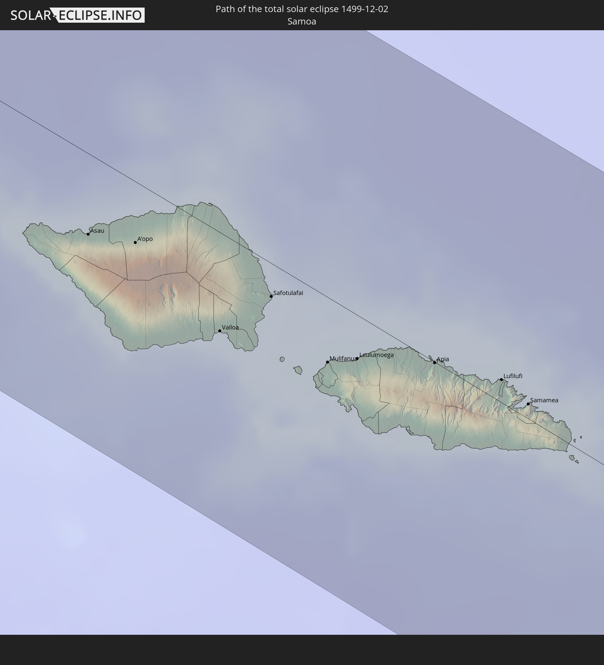 Samoa
Samoa
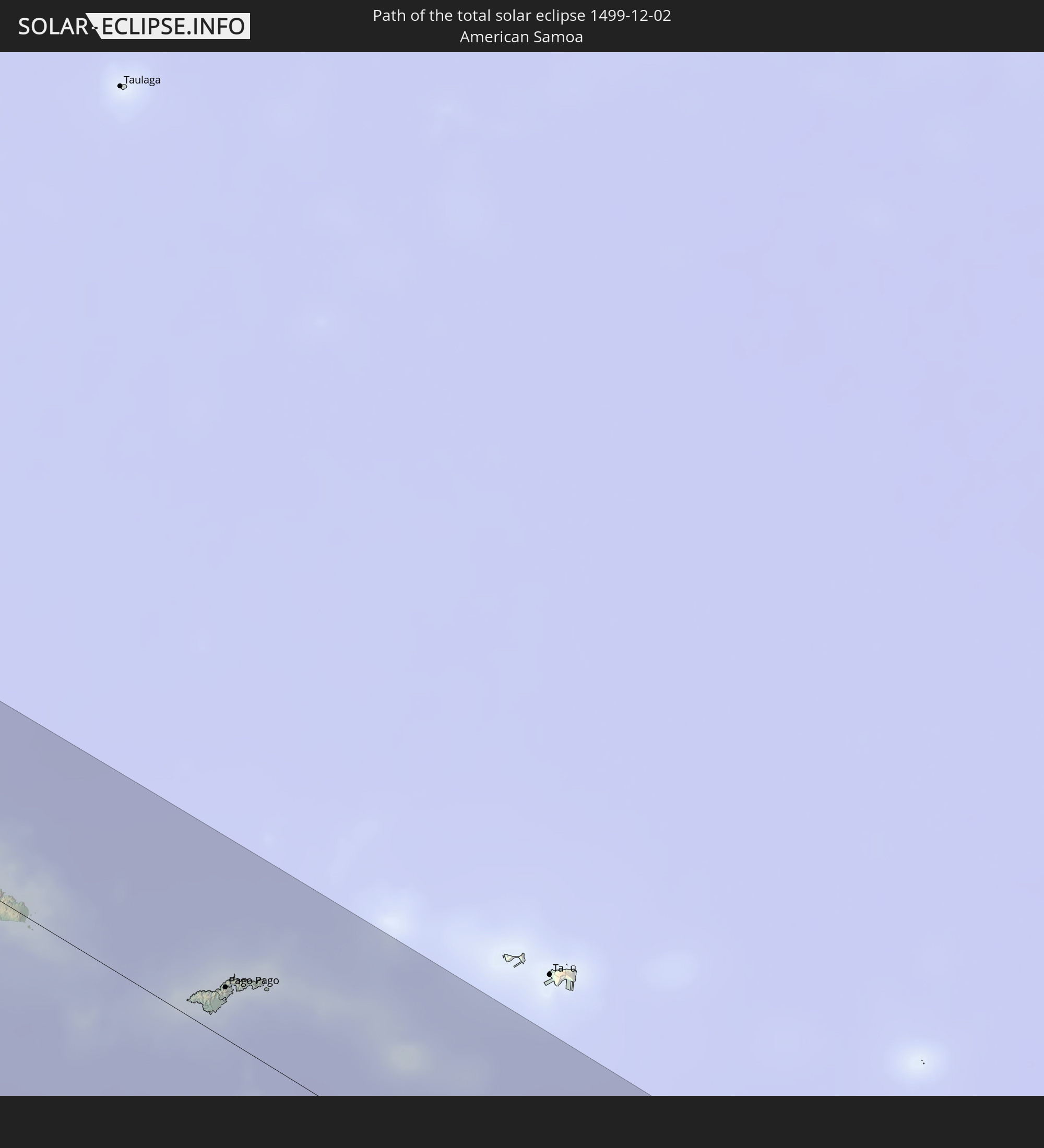 American Samoa
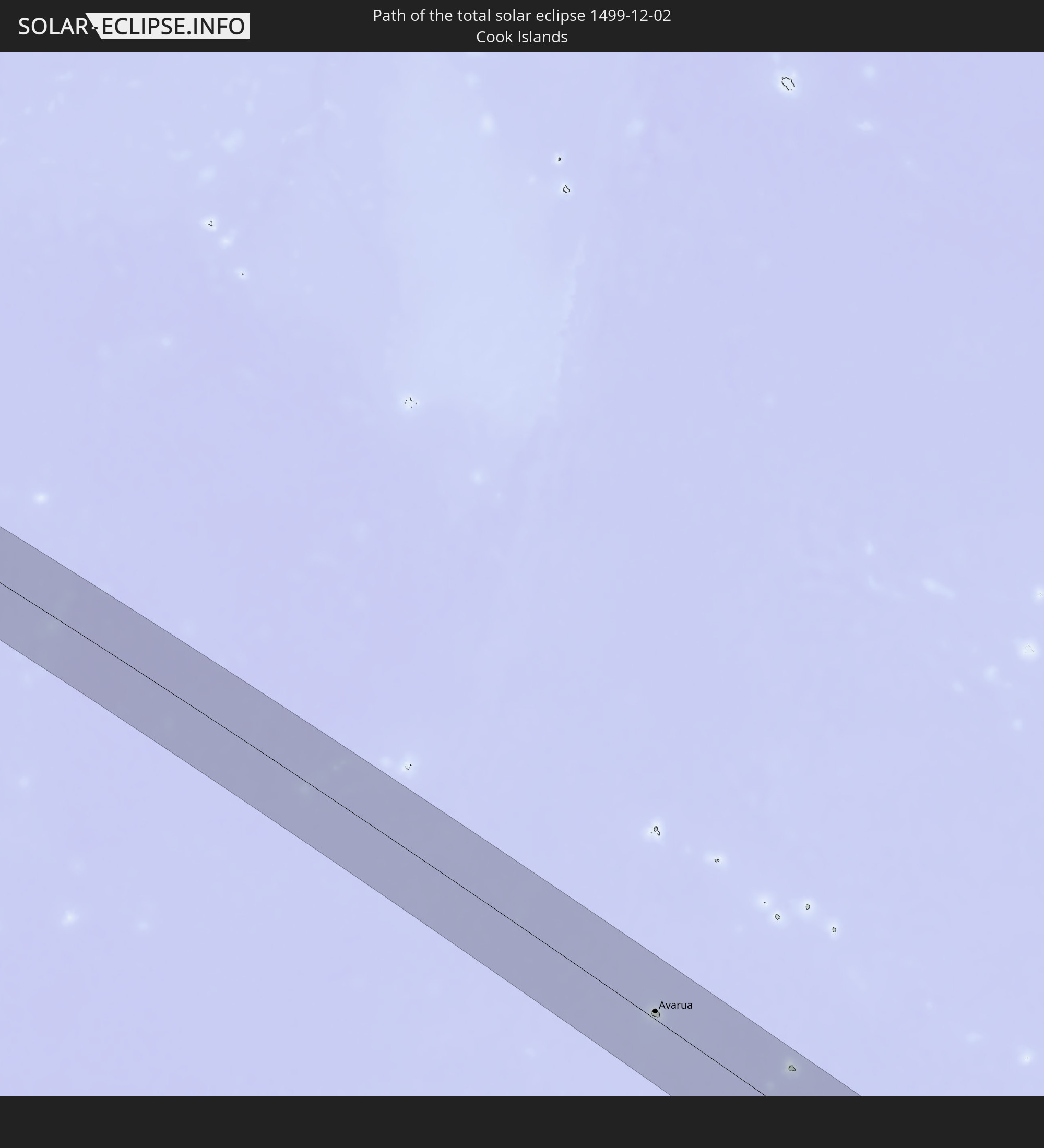 Cook Islands
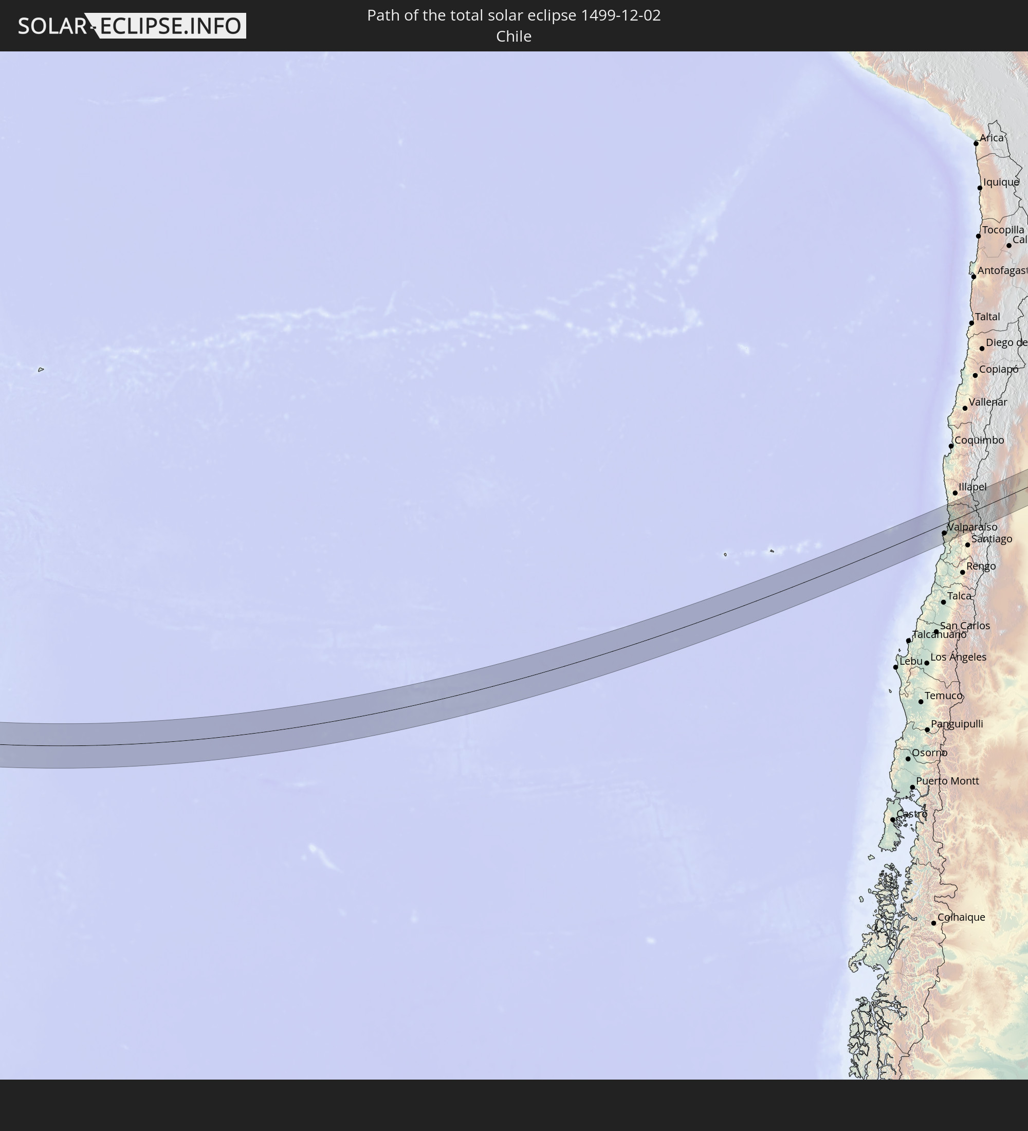 Chile
Chile
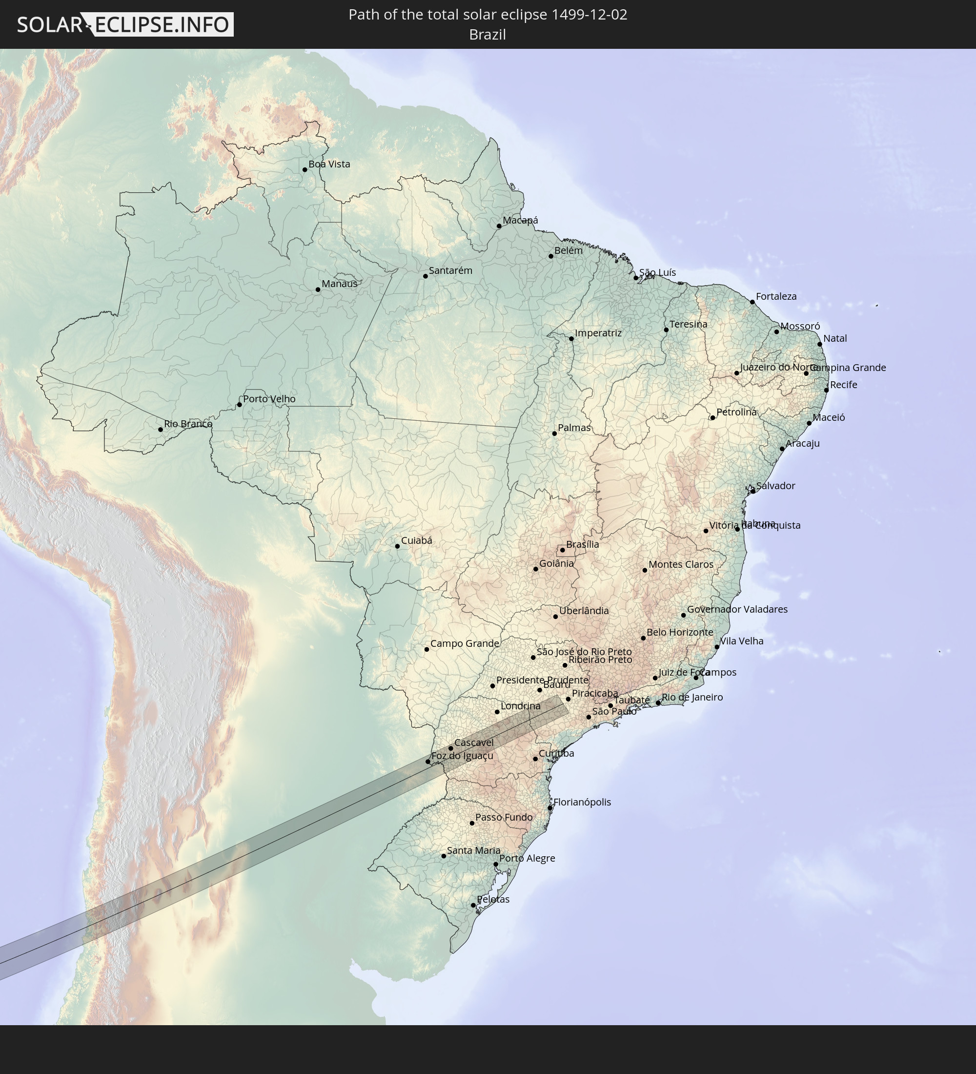 Brazil
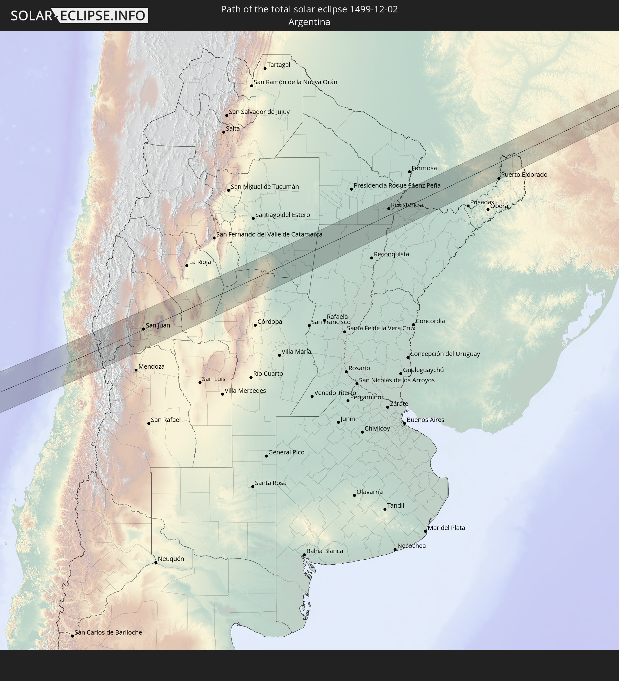 Argentina
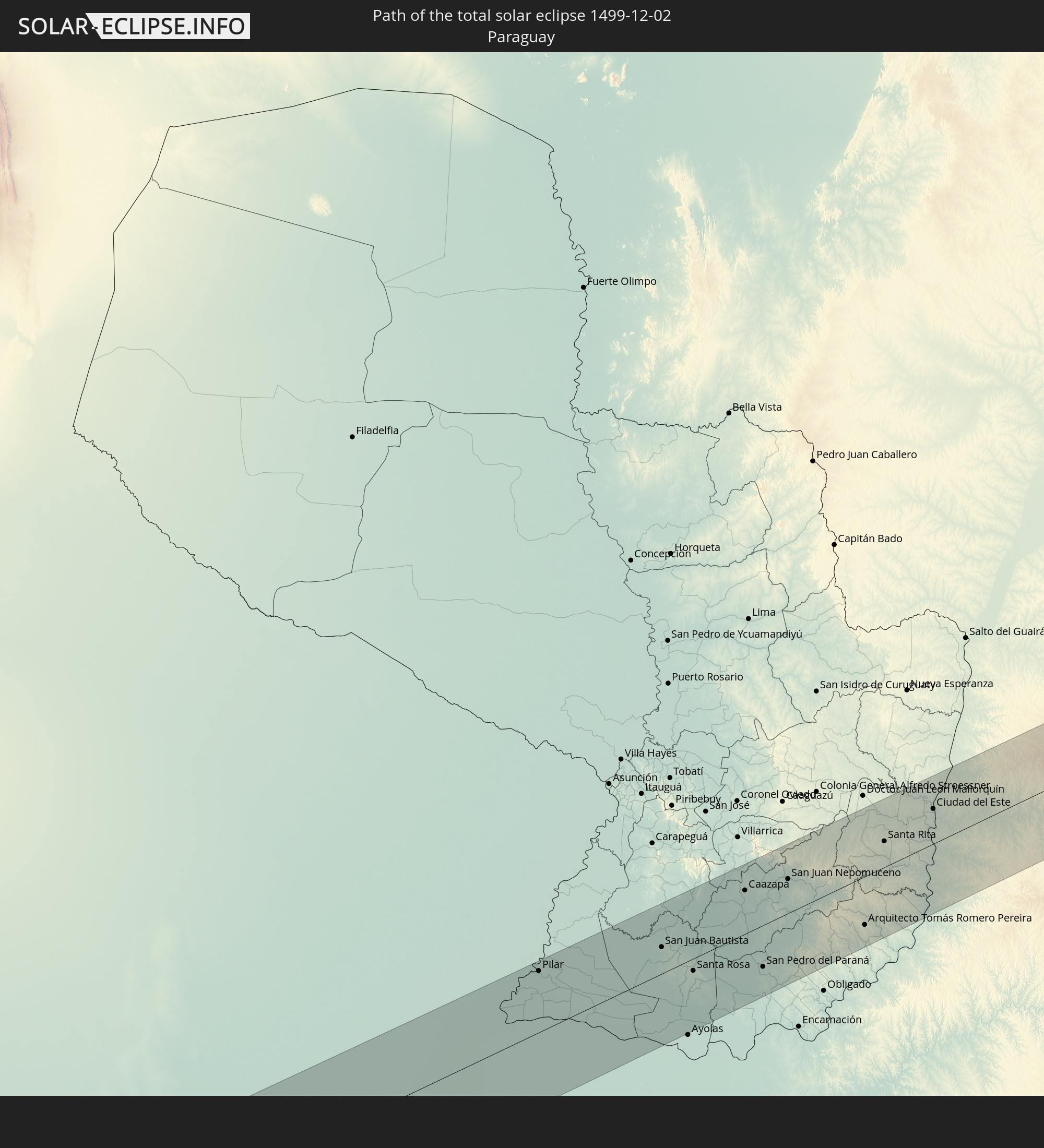 Paraguay
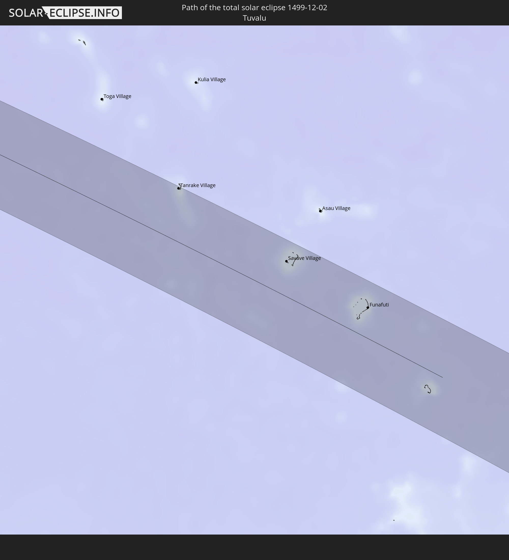 Tuvalu
In den folgenden Ländern ist die Sonnenfinsternis partiell zu sehen
 Fiji
Fiji
 Antarctica
 New Zealand
 United States Minor Outlying Islands
 Wallis and Futuna
 Tonga
Tonga
 Kiribati
 Samoa
Samoa
 Tokelau
 American Samoa
 Niue
Niue
 Cook Islands
 French Polynesia
 Pitcairn Islands
 Chile
Chile
 Ecuador
 Colombia
 Peru
Peru
 Brazil
 Argentina
 Venezuela
 Bolivia
 Paraguay
 Falkland Islands
 Uruguay
 South Georgia and the South Sandwich Islands
 Australia
 Solomon Islands
 New Caledonia
 Vanuatu
 Norfolk Island
 Tuvalu
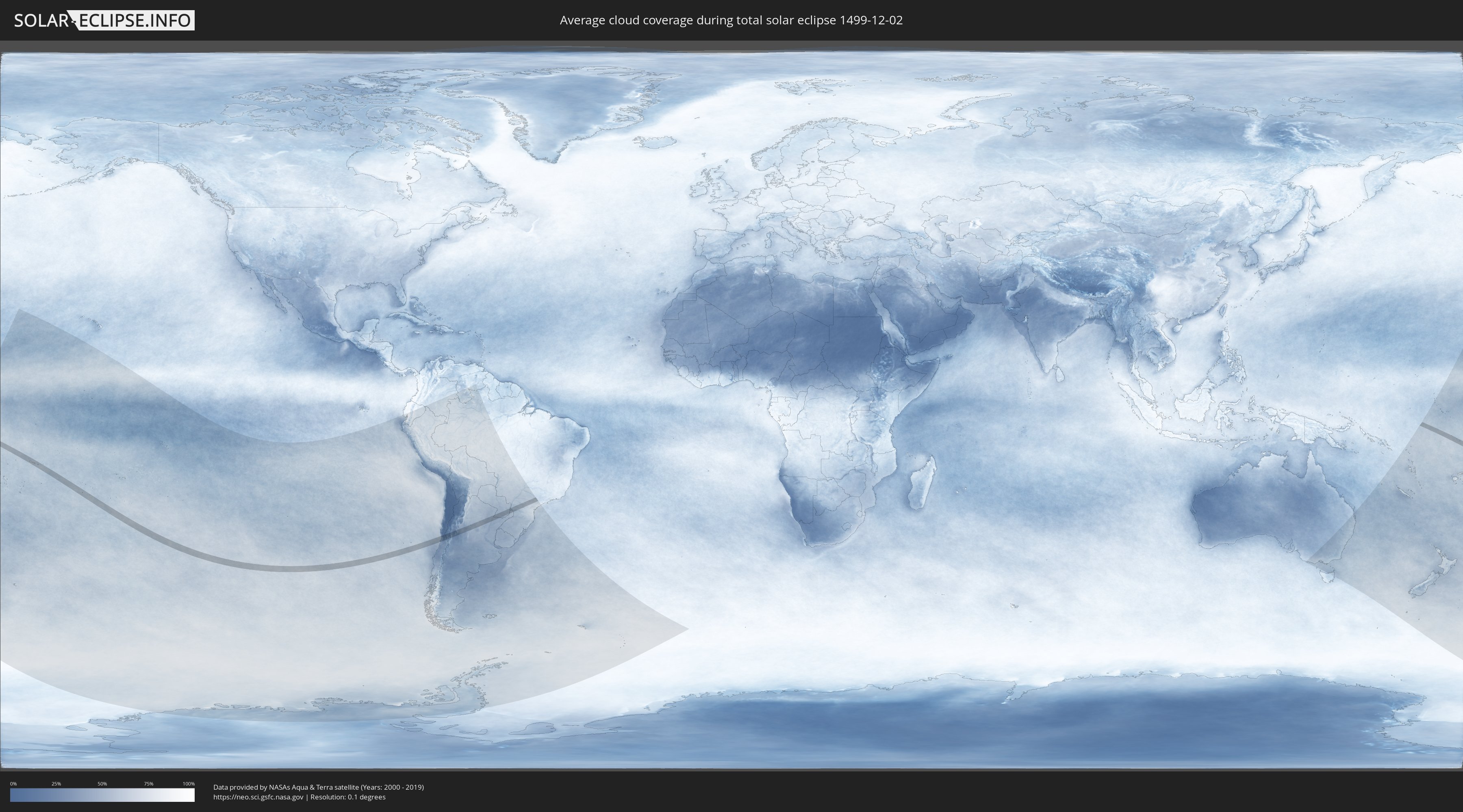
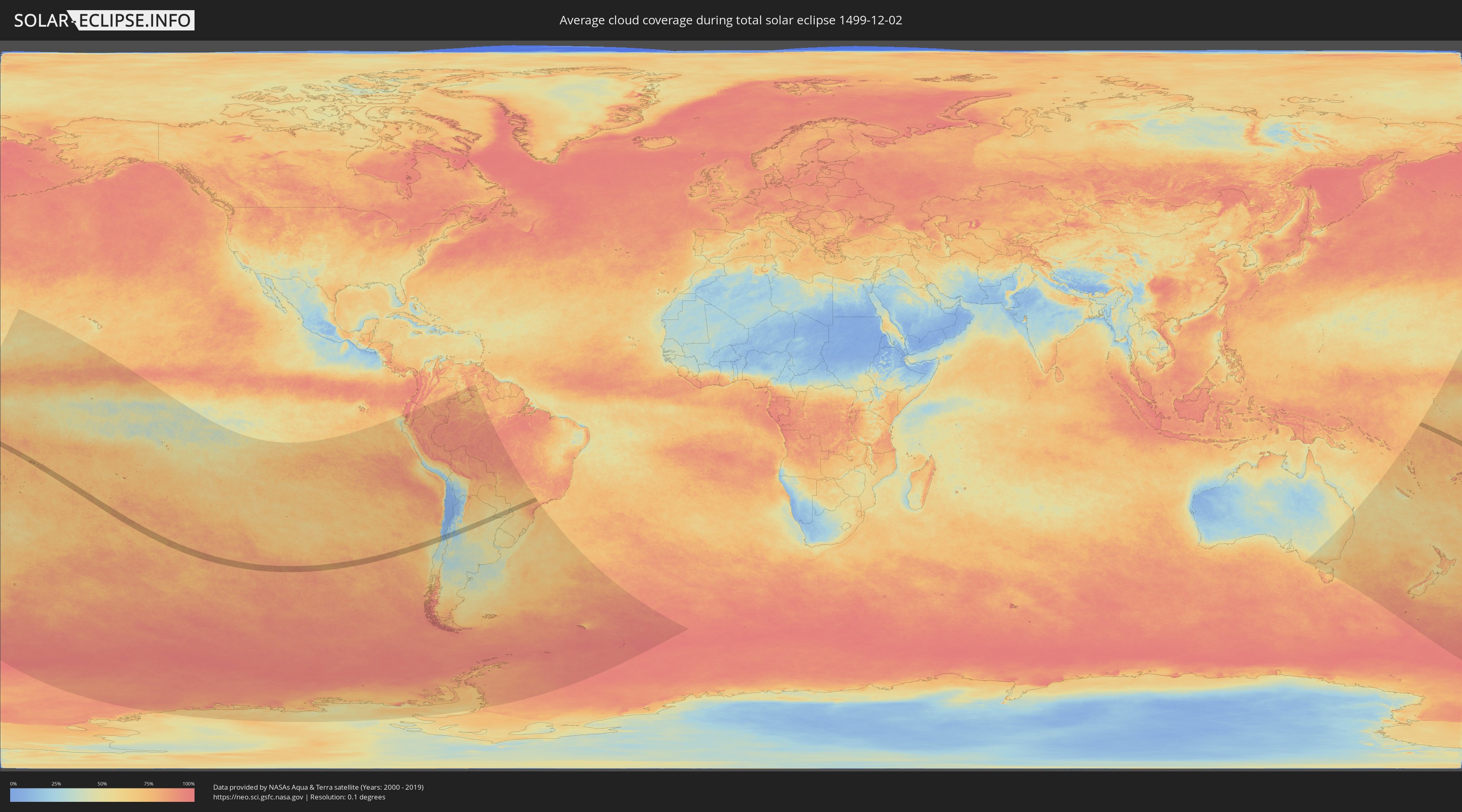
How will be the weather during the total solar eclipse on 12/02/1499?
Where is the best place to see the total solar eclipse of 12/02/1499?
The following maps show the average cloud coverage for the day of the total solar eclipse.
With the help of these maps, it is possible to find the place along the eclipse path, which has the best
chance of a cloudless sky.
Nevertheless, you should consider local circumstances and inform about the weather of your chosen
observation site.
The data is provided by NASAs satellites
AQUA and TERRA.
The cloud maps are averaged over a period of 19 years (2000 - 2019).
Detailed country maps
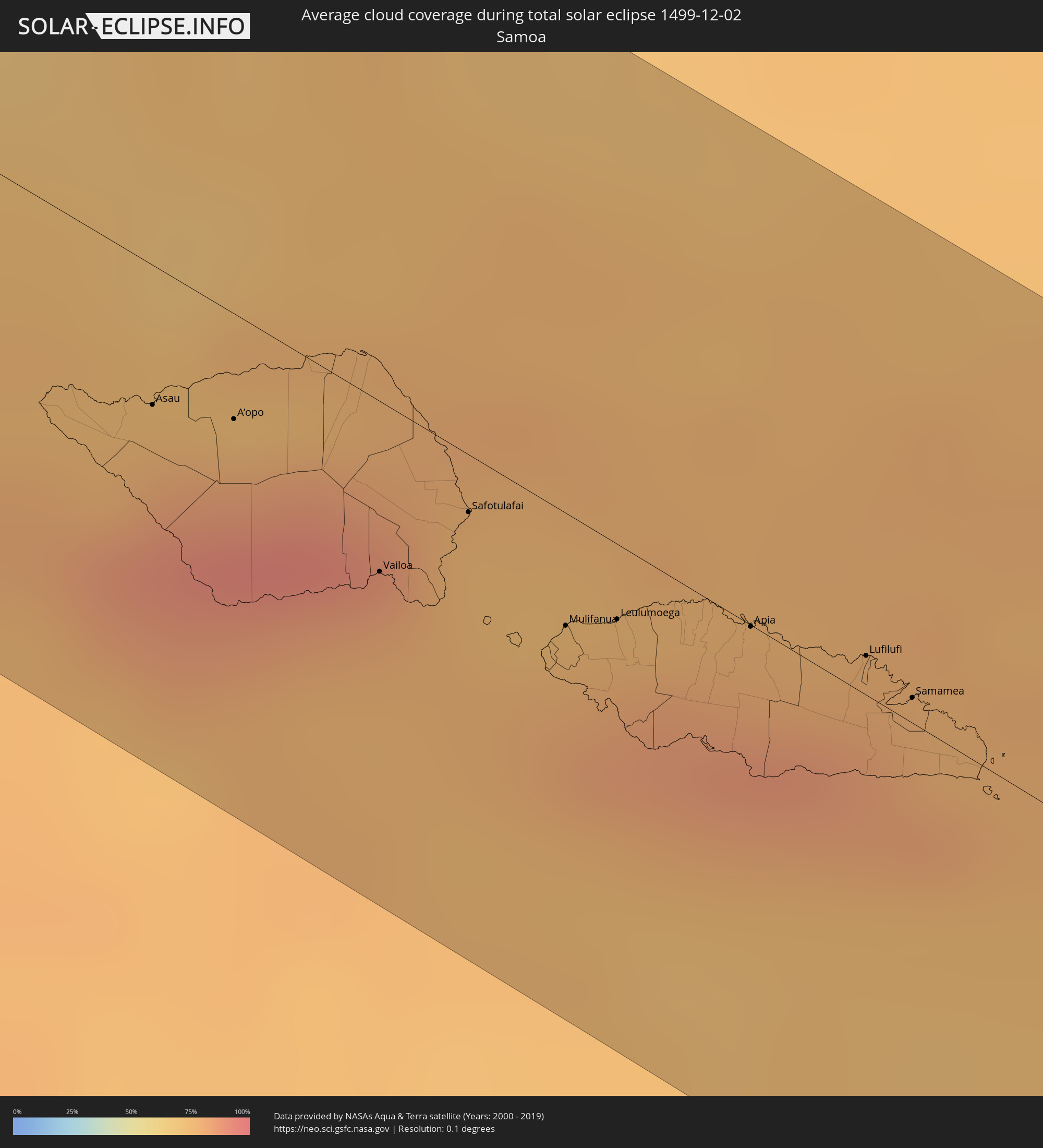 Samoa
Samoa
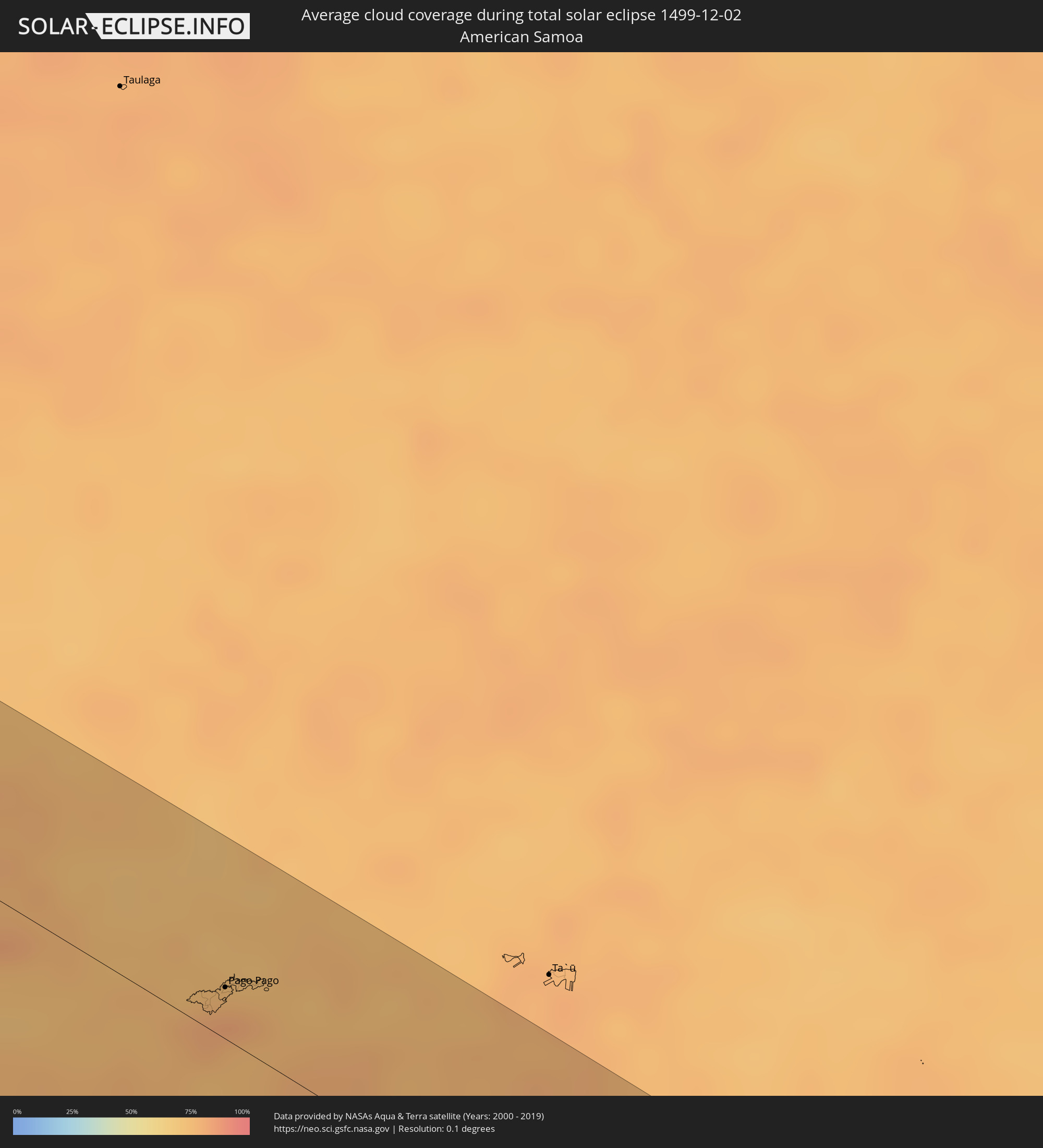 American Samoa
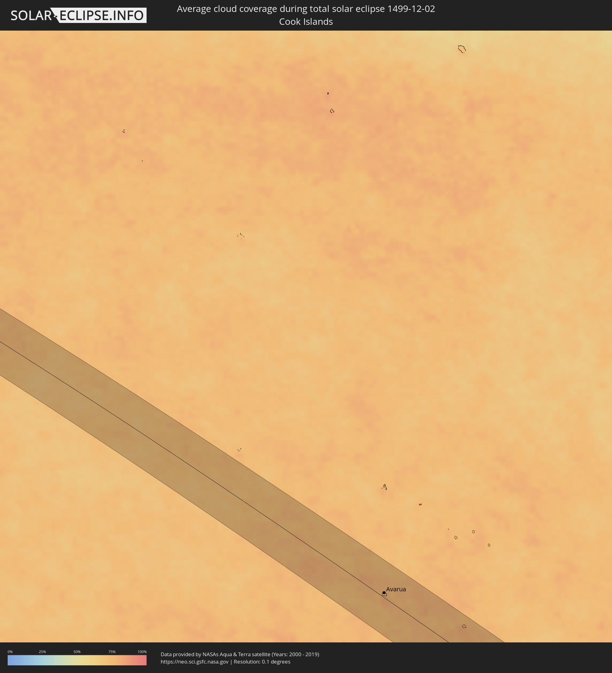 Cook Islands
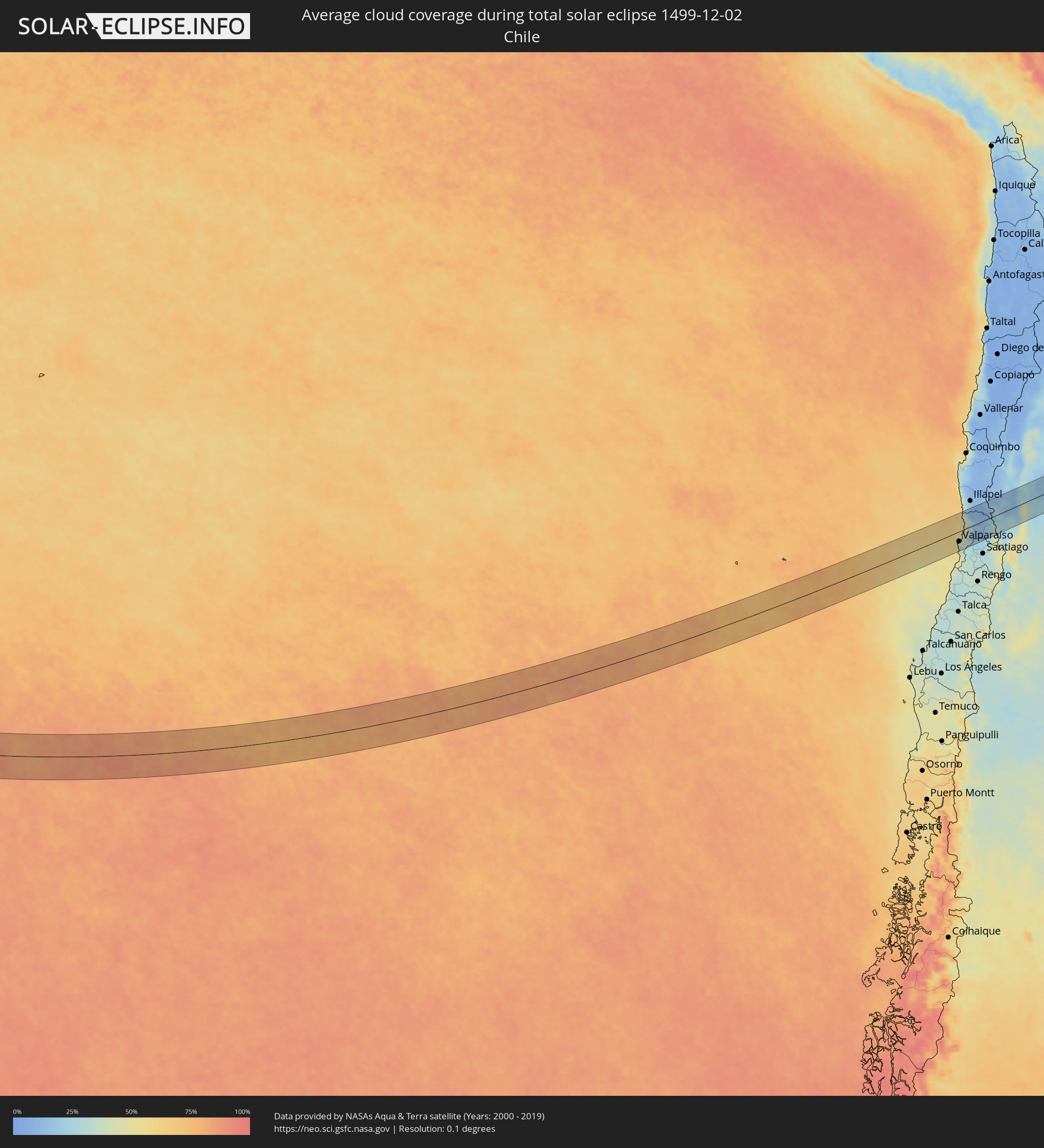 Chile
Chile
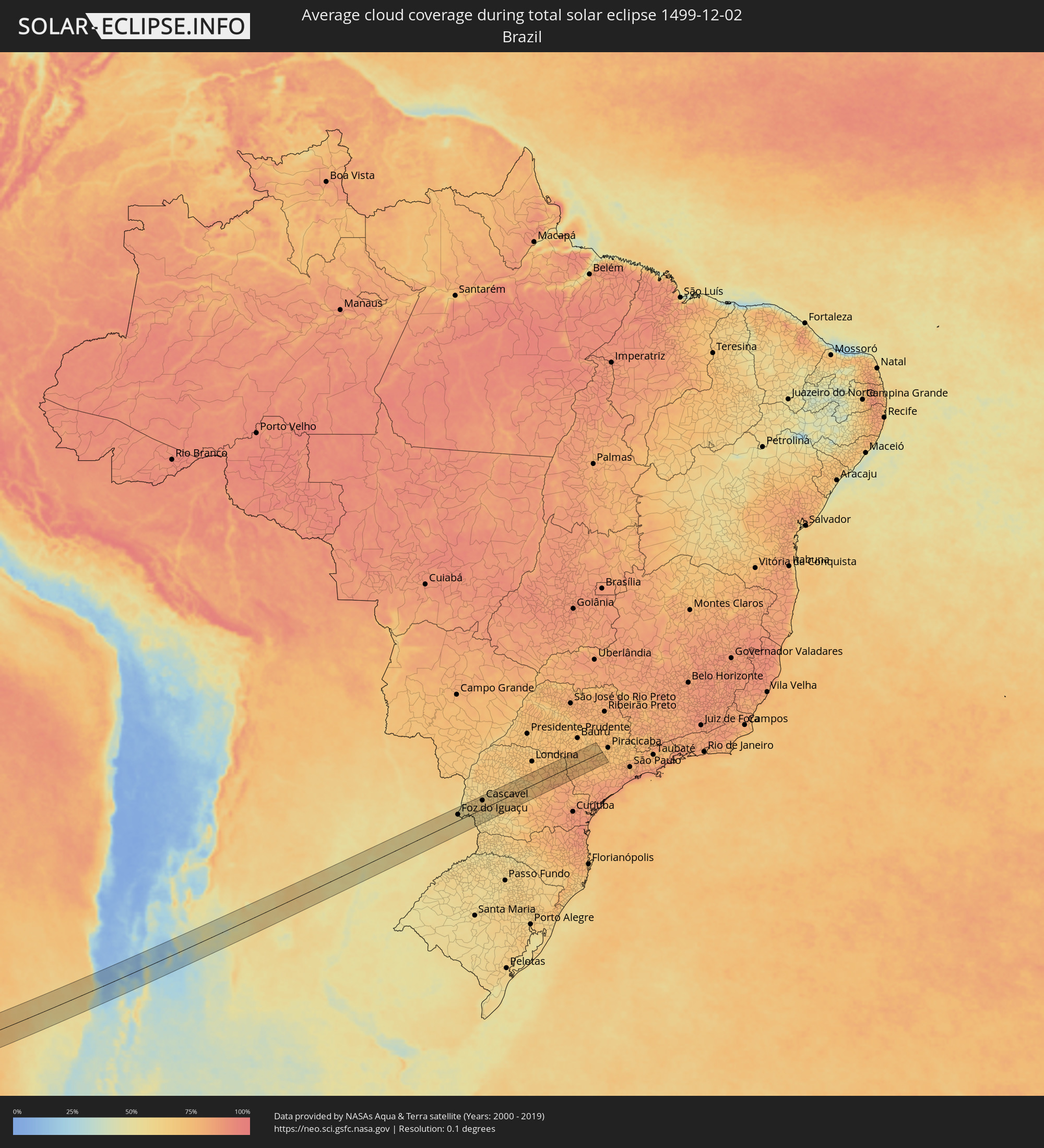 Brazil
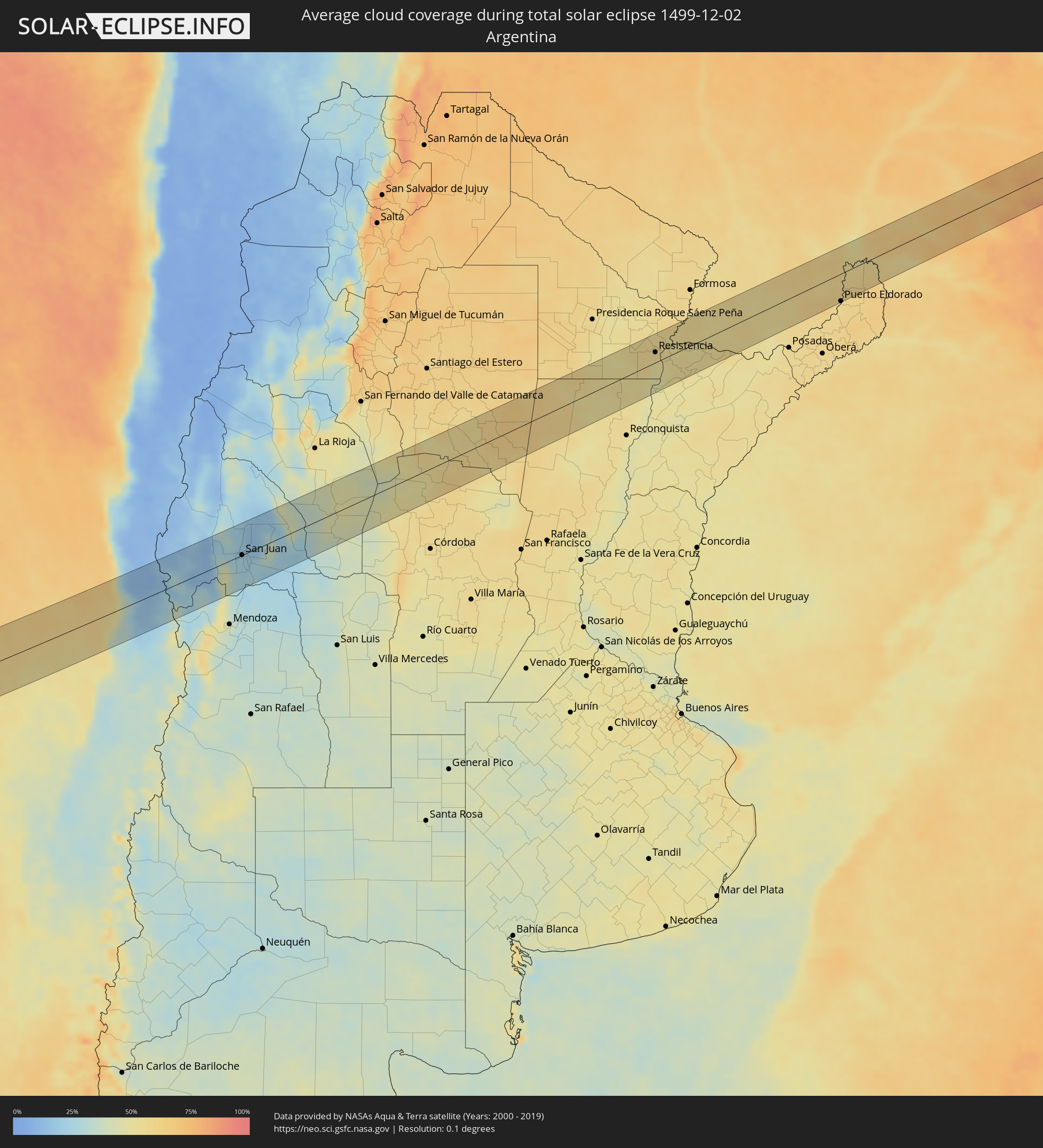 Argentina
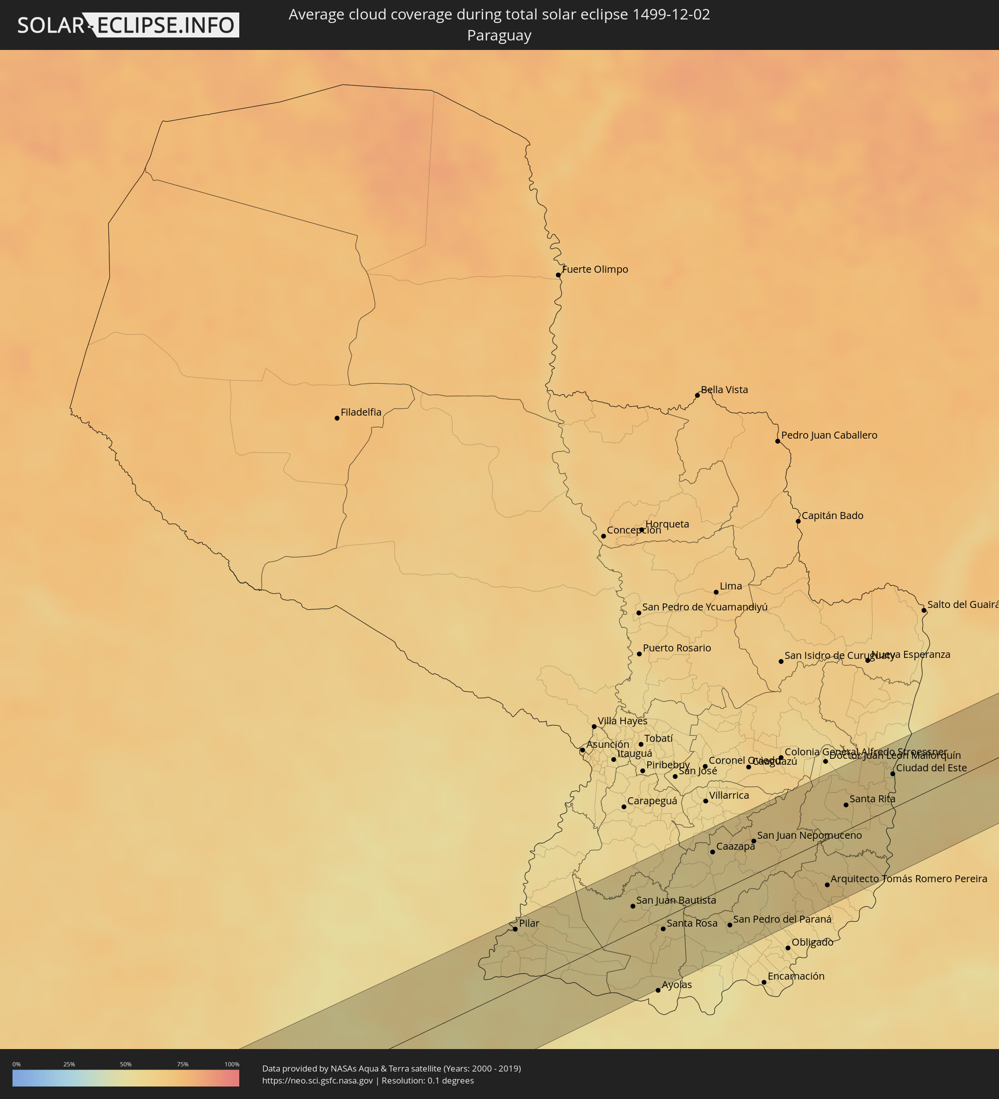 Paraguay
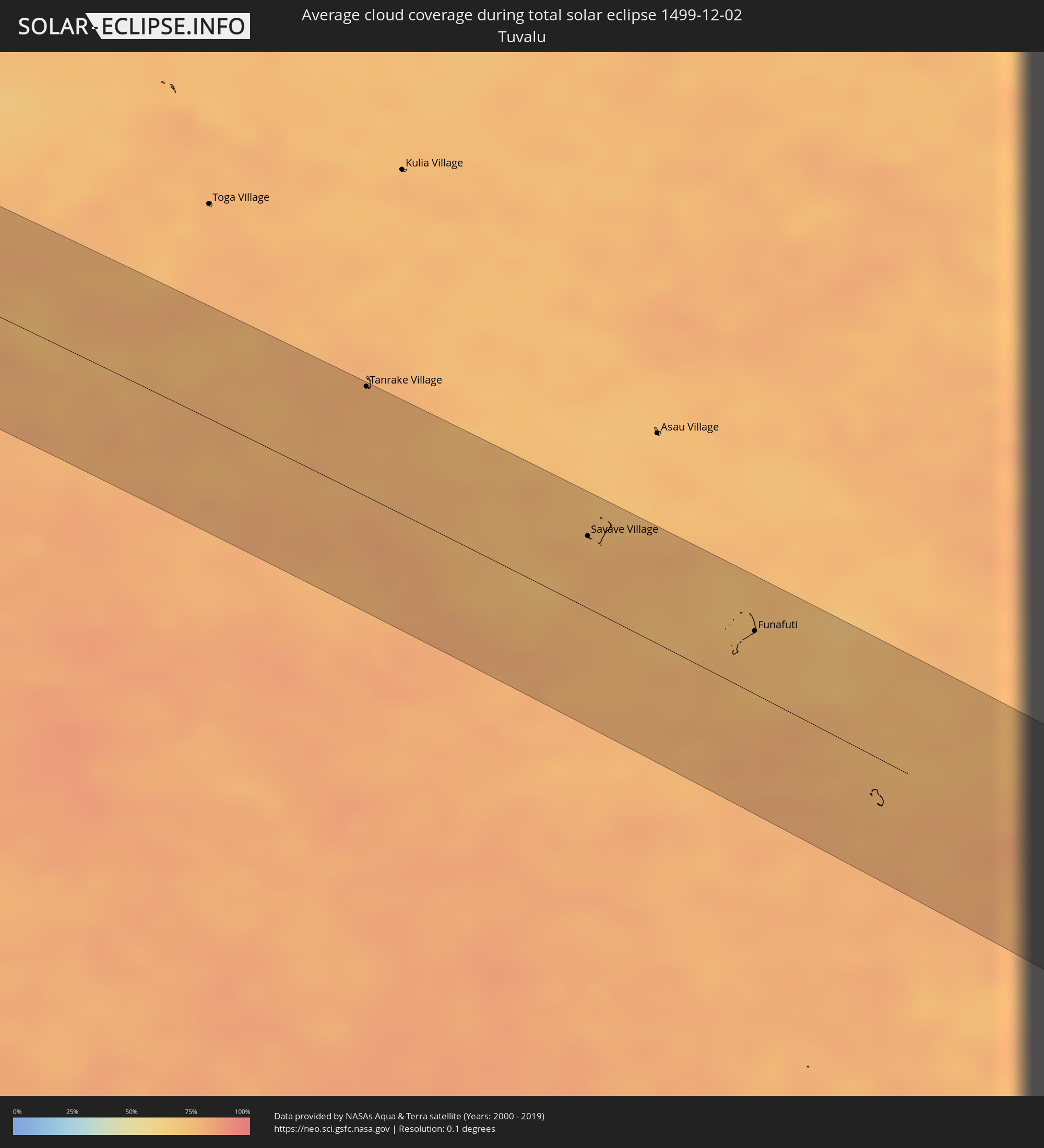 Tuvalu
Cities inside the path of the eclipse
The following table shows all locations with a population of more than 5,000 inside the eclipse path. Cities which have more than 100,000 inhabitants are marked bold. A click at the locations opens a detailed map.
| City | Type | Eclipse duration | Local time of max. eclipse | Distance to central line | Ø Cloud coverage |
|
Asau, Vaisigano
|
total | - | 07:09:20 UTC-11:26 | 19 km | 82% |
|
A’opo, Gagaifomauga
|
total | - | 07:09:24 UTC-11:26 | 14 km | 83% |
|
Vailoa, Palauli
|
total | - | 07:09:41 UTC-11:26 | 23 km | 75% |
|
Safotulafai, Fa‘asaleleaga
|
total | - | 07:09:38 UTC-11:26 | 8 km | 76% |
|
Mulifanua, Aiga-i-le-Tai
|
total | - | 07:09:51 UTC-11:26 | 15 km | 79% |
|
Leulumoega, A'ana
|
total | - | 07:09:52 UTC-11:26 | 10 km | 79% |
|
Apia, Tuamasaga
|
total | - | 07:09:56 UTC-11:26 | 1 km | 80% |
|
Lufilufi, Atua
|
total | - | 07:10:02 UTC-11:26 | 5 km | 83% |
|
Samamea, Va‘a-o-Fonoti
|
total | - | 07:10:07 UTC-11:26 | 3 km | 77% |
|
Tāfuna, Western District
|
total | - | 07:14:58 UTC-11:22 | 11 km | 81% |
|
Pago Pago, Eastern District
|
total | - | 07:14:55 UTC-11:22 | 17 km | 81% |
|
Avarua
|
total | - | 08:22:53 UTC-10:30 | 9 km | 80% |
|
Valparaíso, Valparaíso
|
total | - | 16:54:35 UTC-04:42 | 35 km | 45% |
|
Viña del Mar, Valparaíso
|
total | - | 16:54:38 UTC-04:42 | 36 km | 45% |
|
Quilpué, Valparaíso
|
total | - | 16:54:40 UTC-04:42 | 43 km | 34% |
|
Villa Alemana, Valparaíso
|
total | - | 16:54:42 UTC-04:42 | 45 km | 34% |
|
Limache, Valparaíso
|
total | - | 16:54:47 UTC-04:42 | 46 km | 33% |
|
Quillota, Valparaíso
|
total | - | 16:54:55 UTC-04:42 | 33 km | 31% |
|
La Ligua, Valparaíso
|
total | - | 16:55:21 UTC-04:42 | 10 km | 34% |
|
Hacienda La Calera, Valparaíso
|
total | - | 16:55:02 UTC-04:42 | 24 km | 30% |
|
Llaillay, Valparaíso
|
total | - | 16:55:06 UTC-04:42 | 40 km | 20% |
|
San Felipe, Valparaíso
|
total | - | 16:55:18 UTC-04:42 | 39 km | 17% |
|
Los Andes, Valparaíso
|
total | - | 16:55:16 UTC-04:42 | 53 km | 18% |
|
Calingasta, San Juan Province
|
total | - | 17:23:13 UTC-04:16 | 55 km | 12% |
|
Pocito, San Juan Province
|
total | - | 17:23:12 UTC-04:16 | 13 km | 24% |
|
Villa Paula de Sarmiento, San Juan Province
|
total | - | 17:23:24 UTC-04:16 | 5 km | 26% |
|
San Juan, San Juan Province
|
total | - | 17:23:21 UTC-04:16 | 0 km | 26% |
|
Albardón, San Juan Province
|
total | - | 17:23:27 UTC-04:16 | 10 km | 21% |
|
San Martín, San Juan Province
|
total | - | 17:23:28 UTC-04:16 | 10 km | 21% |
|
Nueve de Julio, San Juan Province
|
total | - | 17:23:17 UTC-04:16 | 19 km | 25% |
|
Caucete, San Juan Province
|
total | - | 17:23:20 UTC-04:16 | 22 km | 25% |
|
San Agustín de Valle Fértil, San Juan Province
|
total | - | 17:24:36 UTC-04:16 | 50 km | 41% |
|
Chamical, La Rioja Province
|
total | - | 17:25:13 UTC-04:16 | 32 km | 49% |
|
Deán Funes, Cordoba Province
|
total | - | 17:25:40 UTC-04:16 | 54 km | 54% |
|
Tostado, Santa Fe Province
|
total | - | 17:27:12 UTC-04:16 | 40 km | 60% |
|
Las Toscas, Santa Fe Province
|
total | - | 17:28:13 UTC-04:16 | 57 km | 51% |
|
Puerto Tirol, Chaco Province
|
total | - | 17:29:02 UTC-04:16 | 34 km | 57% |
|
Fontana, Chaco Province
|
total | - | 17:29:00 UTC-04:16 | 27 km | 58% |
|
Resistencia, Chaco Province
|
total | - | 17:28:58 UTC-04:16 | 21 km | 52% |
|
Puerto Vilelas, Chaco Province
|
total | - | 17:28:55 UTC-04:16 | 14 km | 52% |
|
San Lorenzo, Corrientes Province
|
total | - | 17:28:25 UTC-04:16 | 56 km | 50% |
|
La Leonesa, Chaco Province
|
total | - | 17:29:19 UTC-04:16 | 52 km | 57% |
|
San Luis del Palmar, Corrientes Province
|
total | - | 17:28:56 UTC-04:16 | 2 km | 53% |
|
Pilar, Ñeembucú
|
total | - | 17:55:36 UTC-03:50 | 51 km | 56% |
|
Itatí, Corrientes Province
|
total | - | 17:29:08 UTC-04:16 | 9 km | 51% |
|
San Juan Bautista, Misiones
|
total | - | 17:55:45 UTC-03:50 | 22 km | 55% |
|
Santa Rosa, Misiones
|
total | - | 17:55:36 UTC-03:50 | 10 km | 55% |
|
Caazapá, Caazapá
|
total | - | 17:56:06 UTC-03:50 | 36 km | 56% |
|
San Pedro del Paraná, Itapúa
|
total | - | 17:55:36 UTC-03:50 | 35 km | 53% |
|
San Juan Nepomuceno, Caazapá
|
total | - | 17:56:10 UTC-03:50 | 29 km | 57% |
|
Arquitecto Tomás Romero Pereira, Itapúa
|
total | - | 17:55:50 UTC-03:50 | 41 km | 61% |
|
Santa Rita, Alto Paraná
|
total | - | 17:56:21 UTC-03:50 | 22 km | 57% |
|
Puerto Eldorado, Misiones Province
|
total | - | 17:55:51 UTC-03:50 | 57 km | 56% |
|
Puerto Esperanza, Misiones Province
|
total | - | 17:30:00 UTC-04:16 | 19 km | 56% |
|
Presidente Franco, Alto Paraná
|
total | - | 17:56:30 UTC-03:50 | 27 km | 56% |
|
Ciudad del Este, Alto Paraná
|
total | - | 17:56:31 UTC-03:50 | 29 km | 56% |
|
Foz do Iguaçu, Paraná
|
total | - | 18:40:41 UTC-03:06 | 25 km | 56% |
|
Puerto Iguazú, Misiones Province
|
total | - | 17:30:18 UTC-04:16 | 19 km | 55% |
|
Colonia Wanda, Misiones Province
|
total | - | 17:30:01 UTC-04:16 | 25 km | 57% |
|
São Miguel do Iguaçu, Paraná
|
total | - | 18:40:48 UTC-03:06 | 30 km | 58% |
|
Medianeira, Paraná
|
total | - | 18:40:49 UTC-03:06 | 29 km | 60% |
|
Cascavel, Paraná
|
total | - | 18:40:59 UTC-03:06 | 35 km | 63% |
|
Laranjeiras do Sul, Paraná
|
total | - | 18:40:31 UTC-03:06 | 56 km | 66% |
|
Pitanga, Paraná
|
total | - | 18:40:53 UTC-03:06 | 19 km | 71% |
|
Telêmaco Borba, Paraná
|
total | - | 18:40:58 UTC-03:06 | 25 km | 75% |
|
Ibaiti, Paraná
|
total | - | 18:41:12 UTC-03:06 | 4 km | 75% |
|
Santo Antônio da Platina, Paraná
|
total | - | 18:41:32 UTC-03:06 | 54 km | 72% |
|
Wenceslau Braz, Paraná
|
total | - | 18:41:06 UTC-03:06 | 16 km | 77% |
|
Sengés, Paraná
|
total | - | 18:40:52 UTC-03:06 | 55 km | 80% |
|
Piraju, São Paulo
|
total | - | 18:41:27 UTC-03:06 | 34 km | 74% |
|
Taquarituba, São Paulo
|
total | - | 18:41:12 UTC-03:06 | 6 km | 76% |
|
Cerqueira César, São Paulo
|
total | - | 18:41:30 UTC-03:06 | 41 km | 76% |
|
Itaí, São Paulo
|
total | - | 18:41:14 UTC-03:06 | 1 km | 75% |
|
Avaré, São Paulo
|
total | - | 18:41:24 UTC-03:06 | 24 km | 73% |
|
Paranapanema, São Paulo
|
total | - | 18:41:10 UTC-03:06 | 14 km | 74% |
|
Itatinga, São Paulo
|
total | - | 18:41:19 UTC-03:06 | 10 km | 75% |
|
São Manuel, São Paulo
|
total | - | 18:41:32 UTC-03:06 | 45 km | 73% |
|
Botucatu, São Paulo
|
total | - | 18:41:25 UTC-03:06 | 24 km | 74% |
|
Angatuba, São Paulo
|
total | - | 18:41:01 UTC-03:06 | 38 km | 75% |
|
Conchas, São Paulo
|
total | - | 18:41:13 UTC-03:06 | 10 km | 72% |
|
Tatuí, São Paulo
|
total | - | 18:40:57 UTC-03:06 | 50 km | 76% |
|
Laranjal Paulista, São Paulo
|
total | - | 18:41:09 UTC-03:06 | 19 km | 73% |
|
Boituva, São Paulo
|
total | - | 18:40:57 UTC-03:06 | 50 km | 75% |
|
Tanrake Village, Nui
|
total | - | 06:29:30 UTC+12:00 | 57 km | 78% |
|
Savave Village, Nukufetau
|
total | - | 06:30:03 UTC+12:00 | 37 km | 78% |
|
Funafuti, Funafuti
|
total | - | 06:30:27 UTC+12:00 | 32 km | 75% |