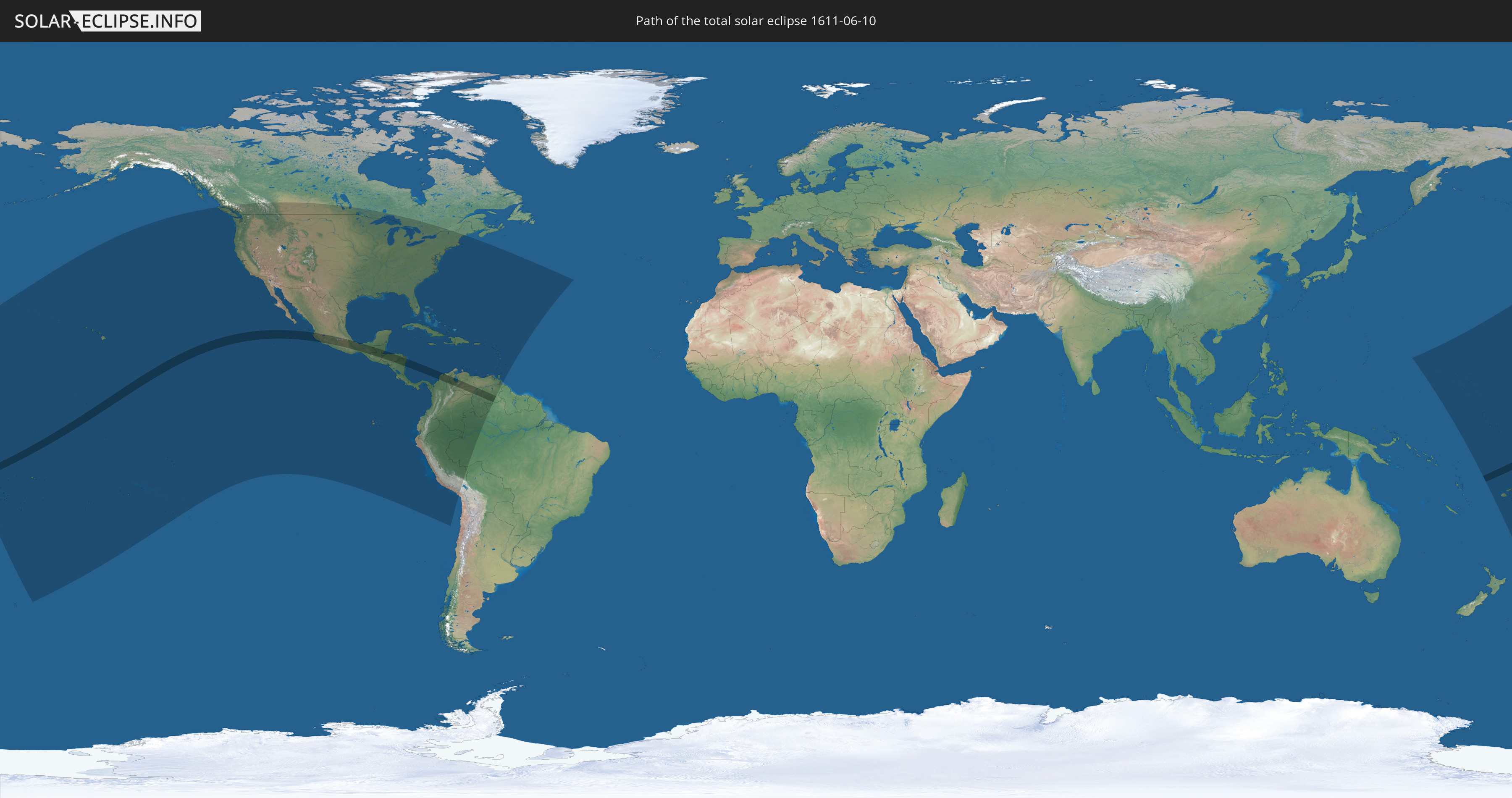
Total solar eclipse of 06/10/1611
| Day of week: | Friday |
| Maximum duration of eclipse: | 06m16s |
| Maximum width of eclipse path: | 224 km |
| Saros cycle: | 121 |
| Coverage: | 100% |
| Magnitude: | 1.0686 |
| Gamma: | -0.0836 |
Wo kann man die Sonnenfinsternis vom 06/10/1611 sehen?
Die Sonnenfinsternis am 06/10/1611 kann man in 58 Ländern als partielle Sonnenfinsternis beobachten.
Der Finsternispfad verläuft durch 11 Länder. Nur in diesen Ländern ist sie als total Sonnenfinsternis zu sehen.
In den folgenden Ländern ist die Sonnenfinsternis total zu sehen
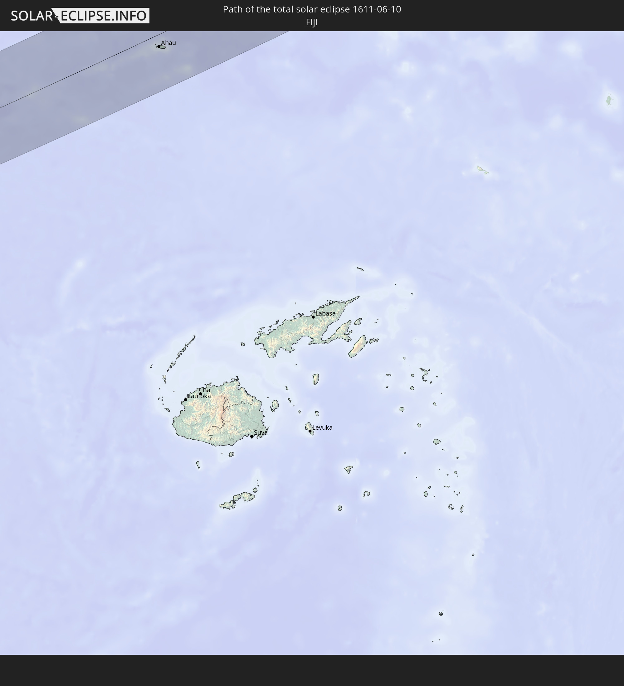 Fiji
Fiji
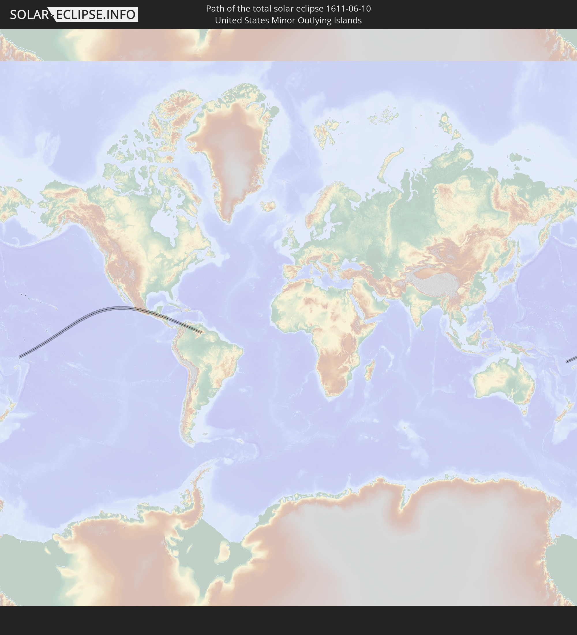 United States Minor Outlying Islands
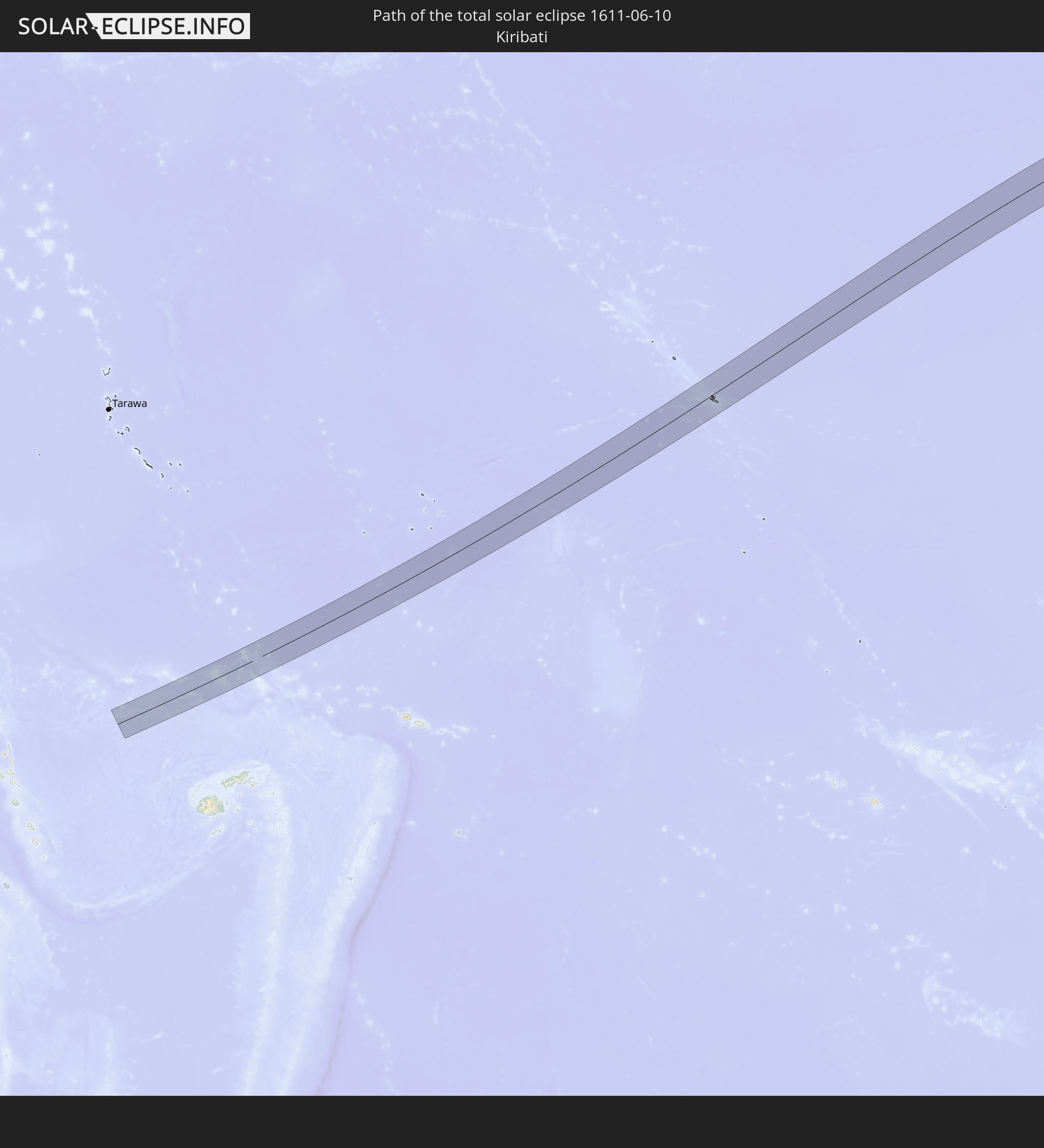 Kiribati
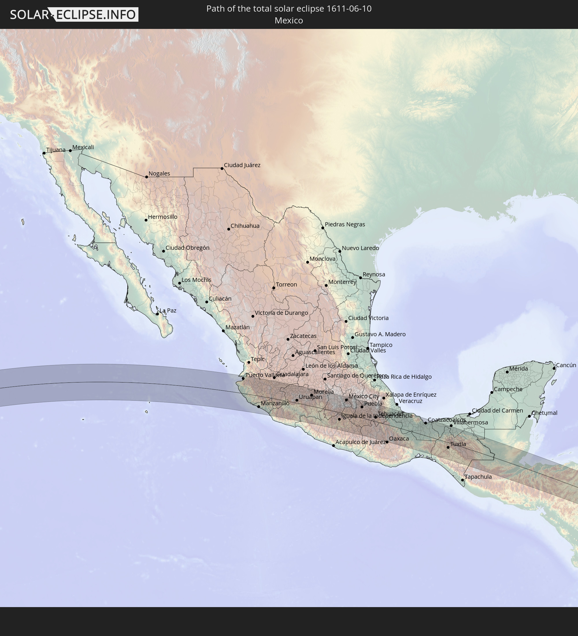 Mexico
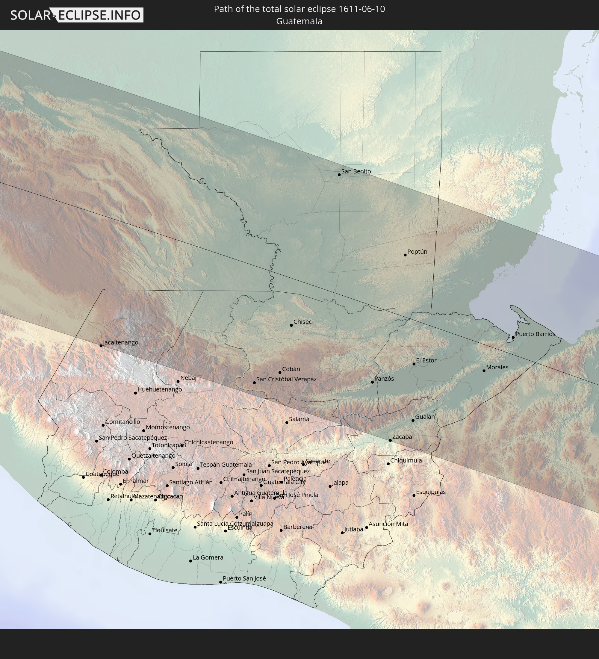 Guatemala
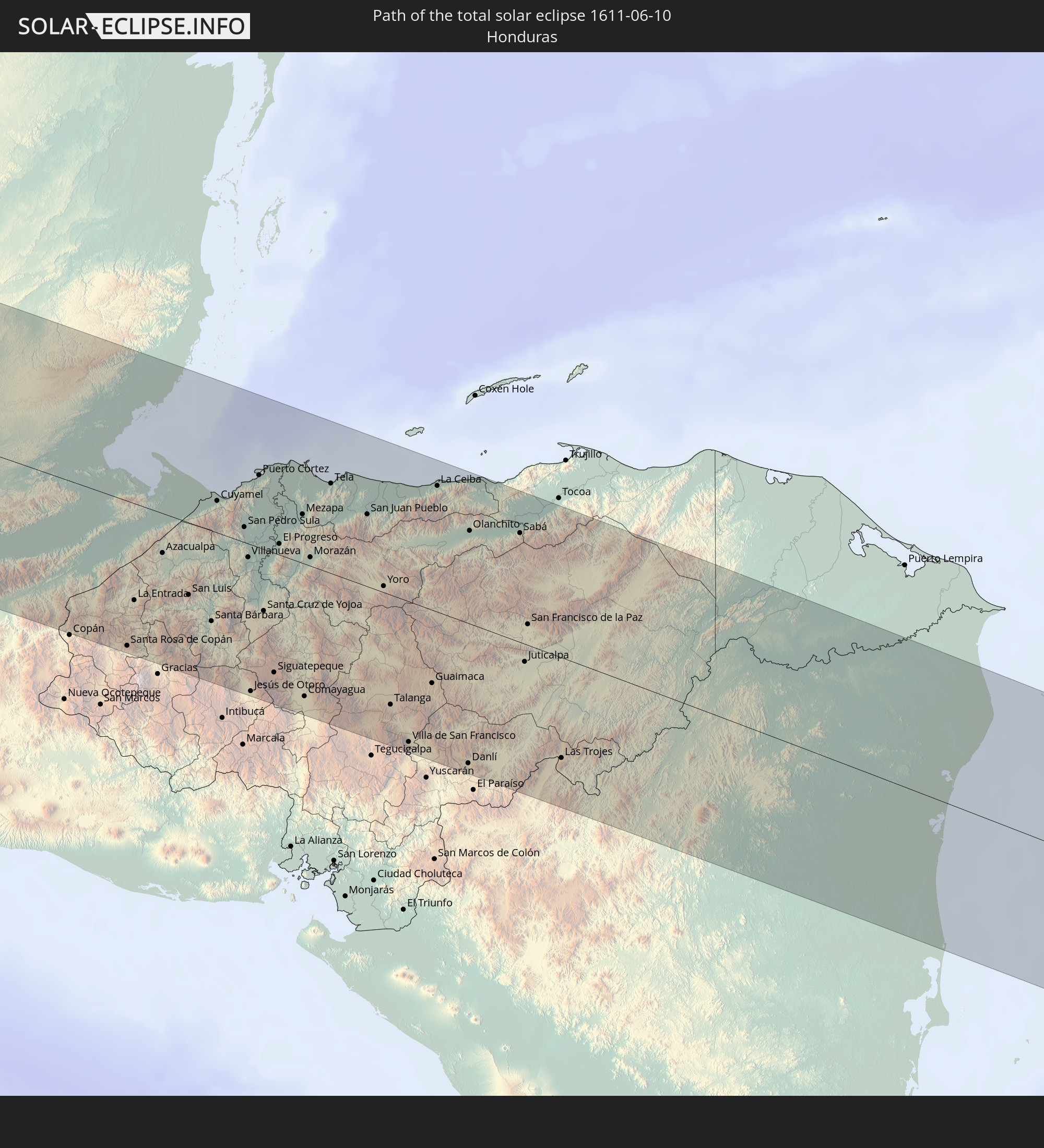 Honduras
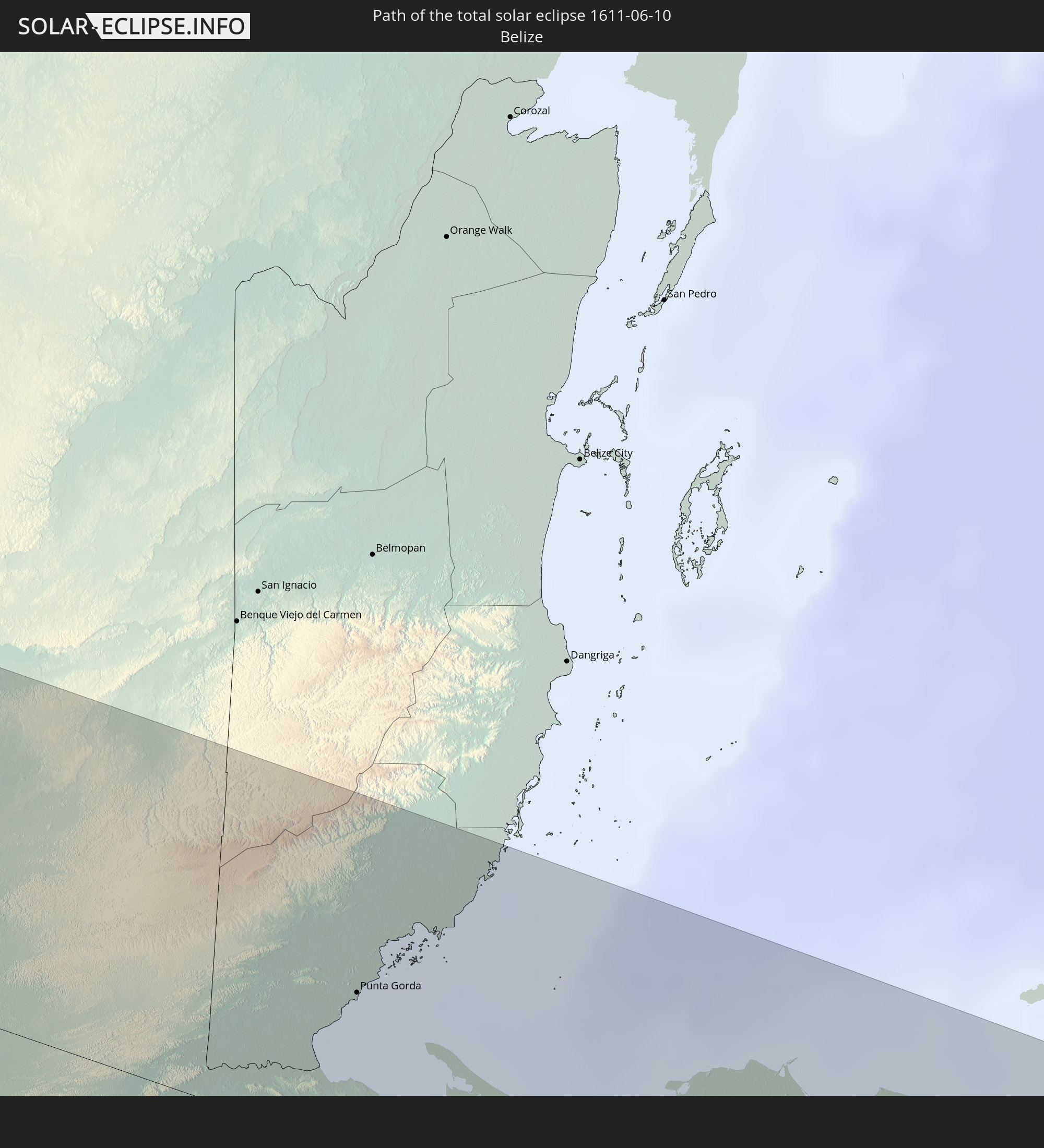 Belize
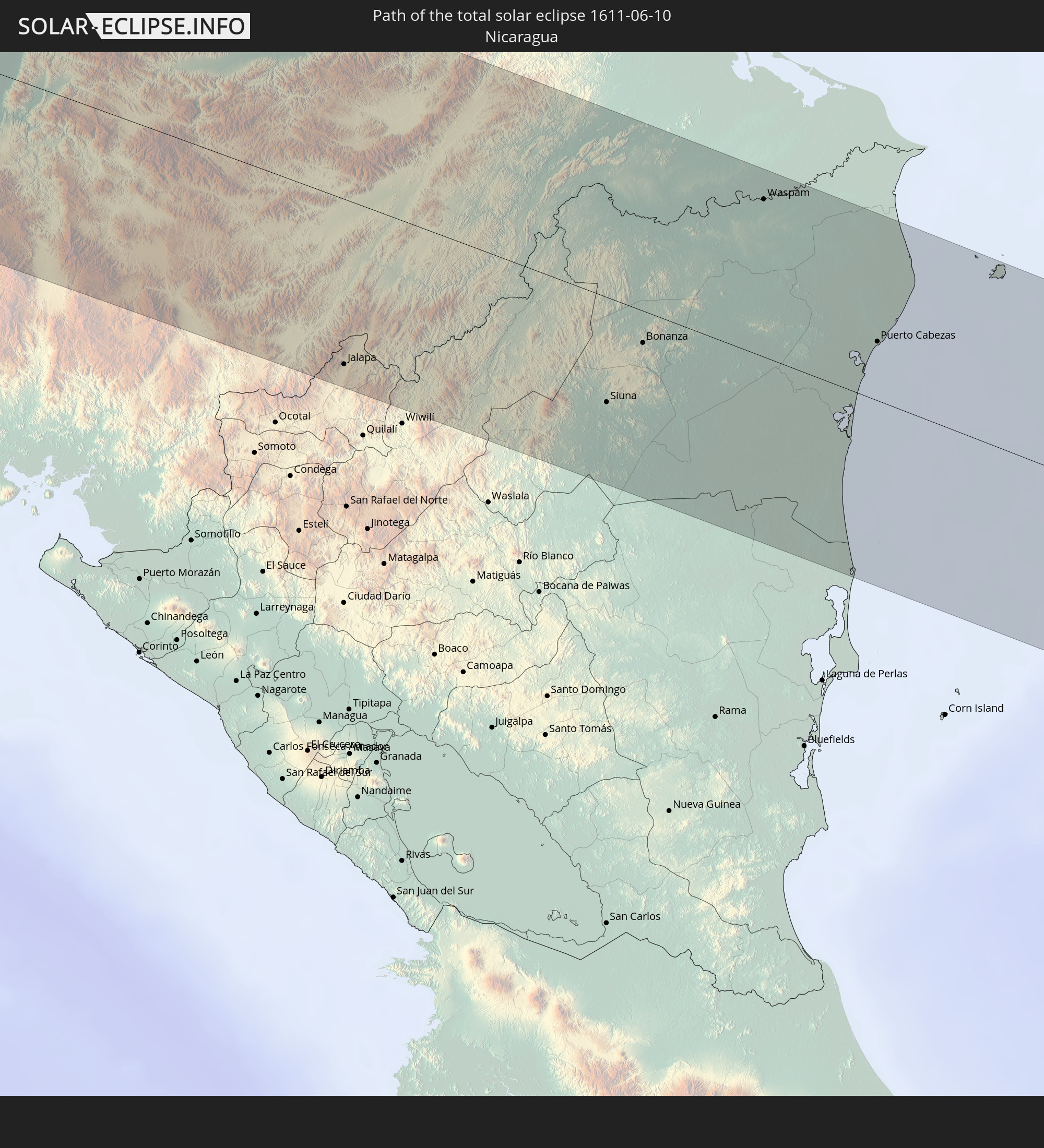 Nicaragua
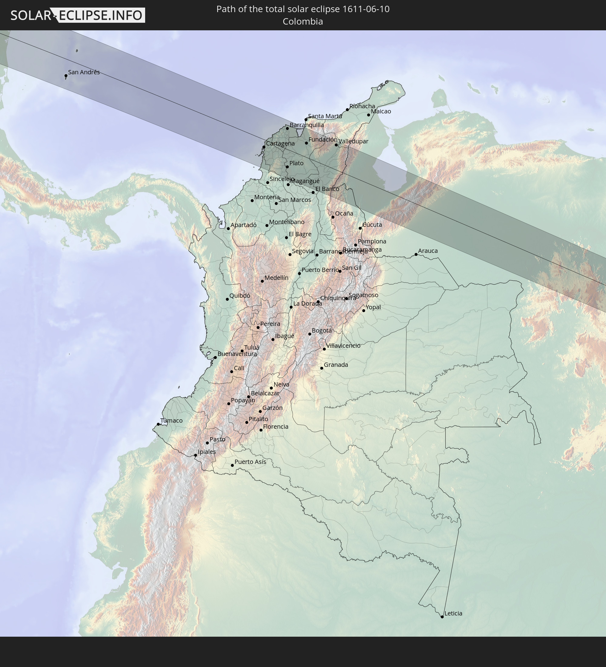 Colombia
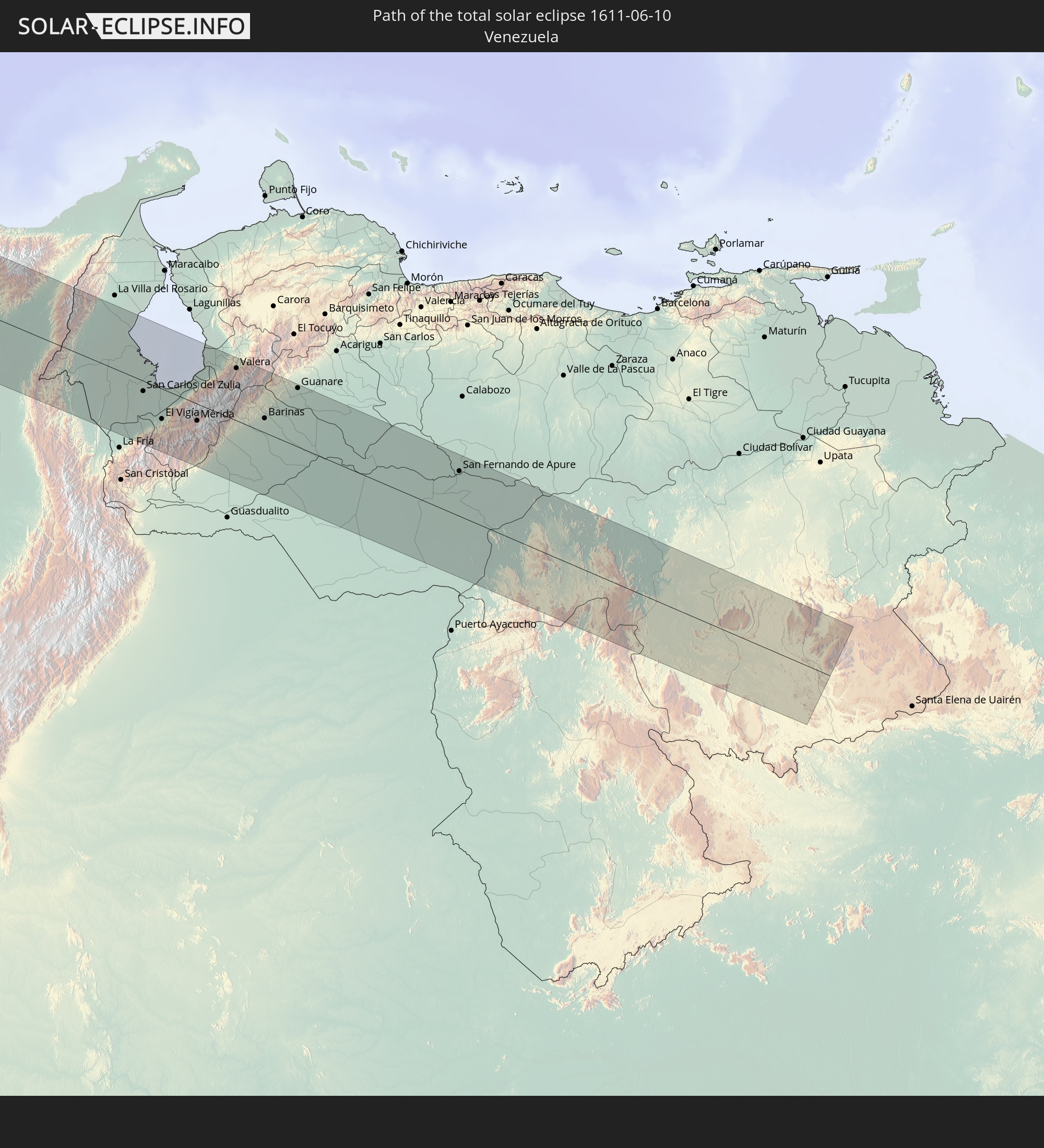 Venezuela
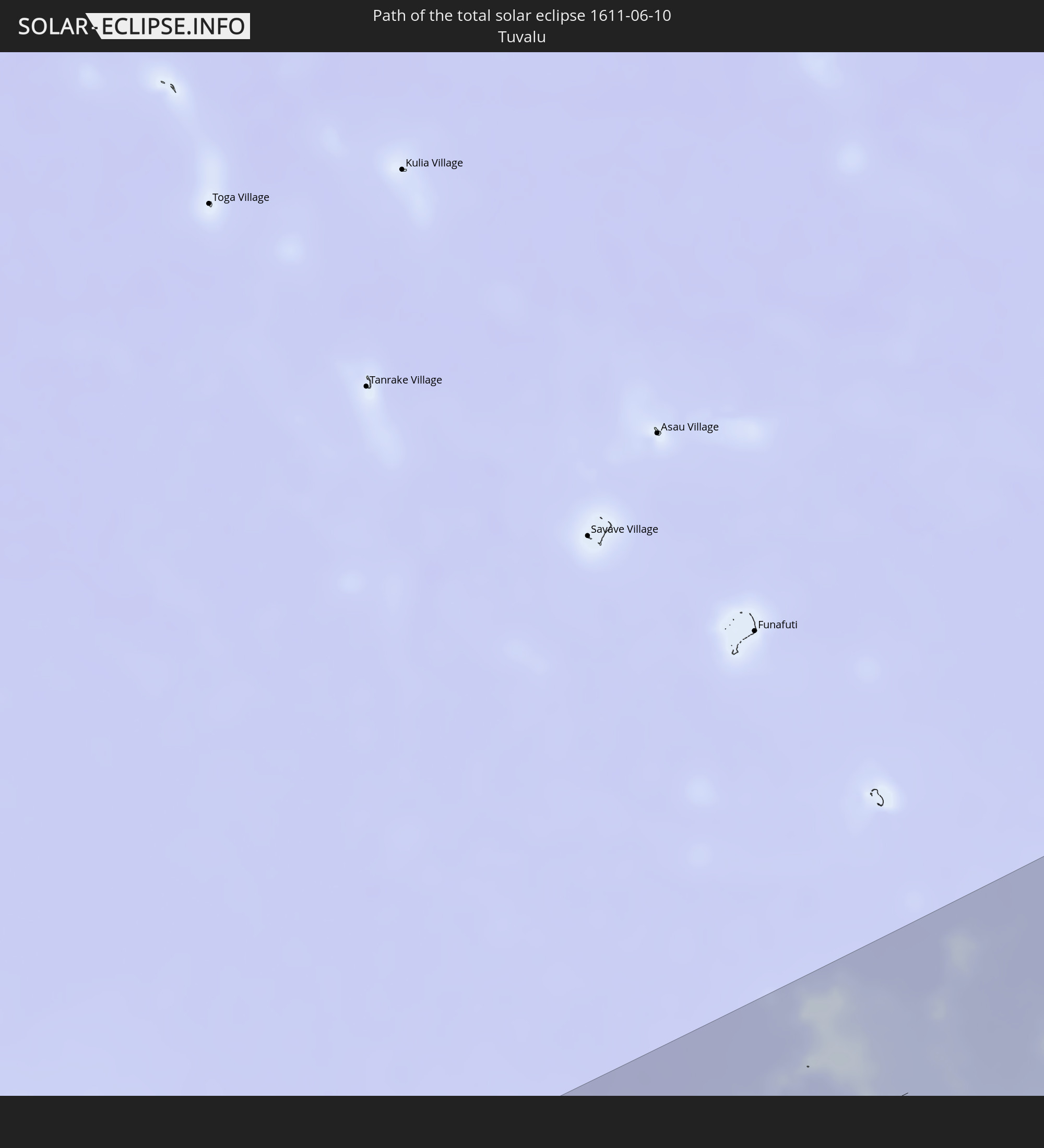 Tuvalu
In den folgenden Ländern ist die Sonnenfinsternis partiell zu sehen
 Fiji
Fiji
 United States
 New Zealand
 United States Minor Outlying Islands
 Wallis and Futuna
 Tonga
Tonga
 Kiribati
 Samoa
Samoa
 Tokelau
 American Samoa
 Niue
Niue
 Cook Islands
 French Polynesia
 Canada
 Mexico
 Guatemala
 Ecuador
 El Salvador
 Honduras
 Belize
 Nicaragua
 Costa Rica
 Cuba
Cuba
 Panama
 Colombia
 Cayman Islands
 Peru
Peru
 The Bahamas
 Jamaica
 Haiti
Haiti
 Brazil
 Venezuela
 Turks and Caicos Islands
 Dominican Republic
 Aruba
Aruba
 Bolivia
 Puerto Rico
 United States Virgin Islands
 Bermuda
 British Virgin Islands
 Anguilla
 Collectivity of Saint Martin
 Saint Barthélemy
 Saint Kitts and Nevis
 Antigua and Barbuda
 Montserrat
 Trinidad and Tobago
 Guadeloupe
 Grenada
 Dominica
 Saint Vincent and the Grenadines
 Martinique
 Saint Lucia
 Barbados
 Federated States of Micronesia
 Marshall Islands
 Nauru
Nauru
 Tuvalu
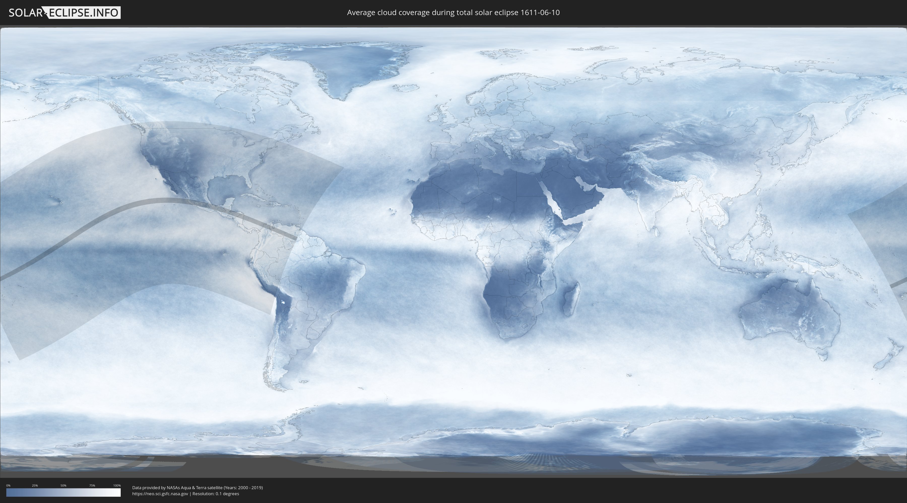
How will be the weather during the total solar eclipse on 06/10/1611?
Where is the best place to see the total solar eclipse of 06/10/1611?
The following maps show the average cloud coverage for the day of the total solar eclipse.
With the help of these maps, it is possible to find the place along the eclipse path, which has the best
chance of a cloudless sky.
Nevertheless, you should consider local circumstances and inform about the weather of your chosen
observation site.
The data is provided by NASAs satellites
AQUA and TERRA.
The cloud maps are averaged over a period of 19 years (2000 - 2019).

Detailed country maps
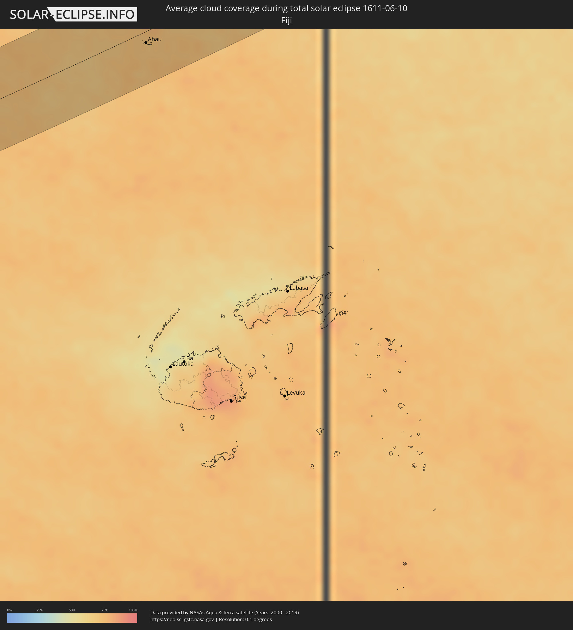 Fiji
Fiji
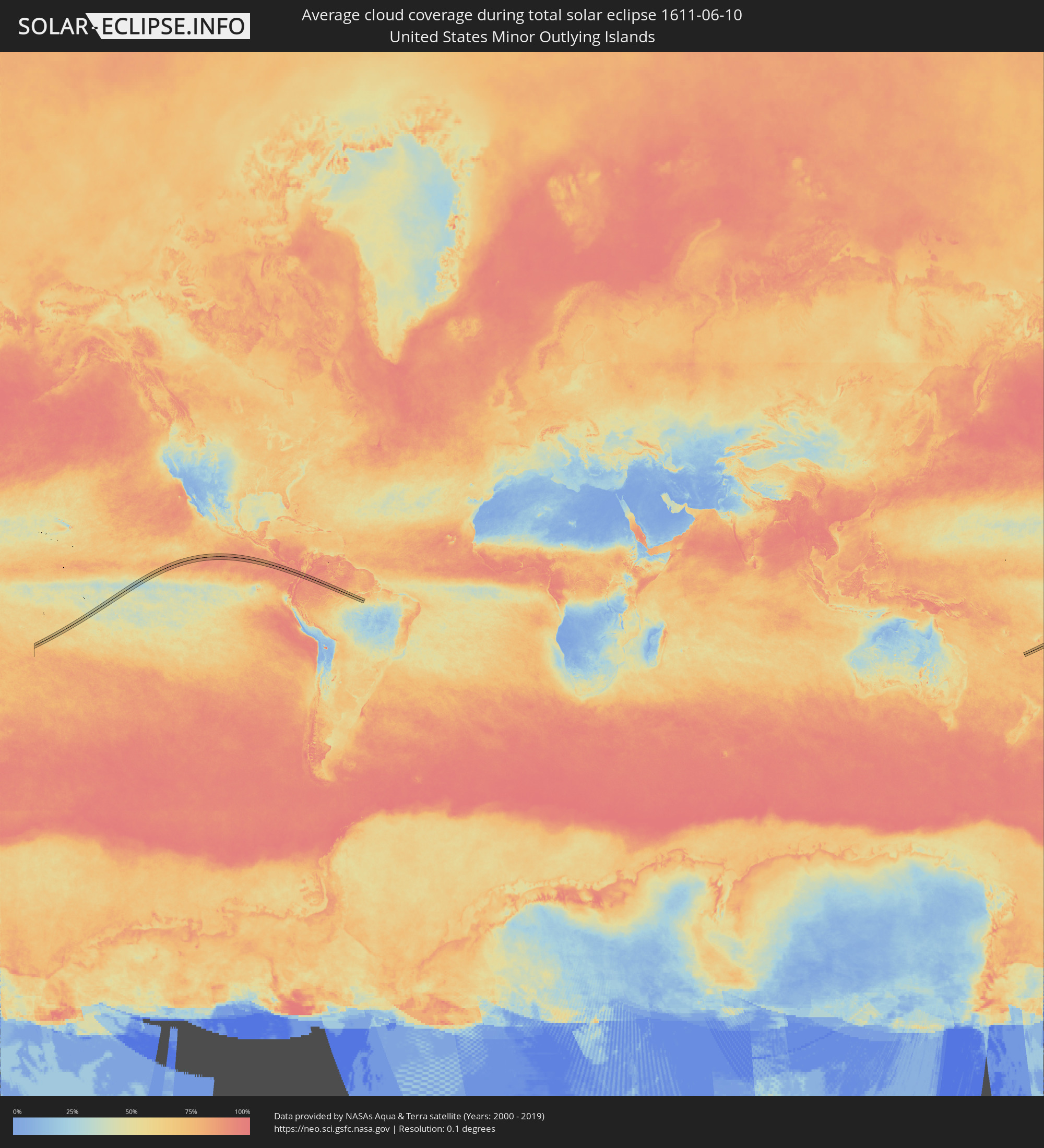 United States Minor Outlying Islands
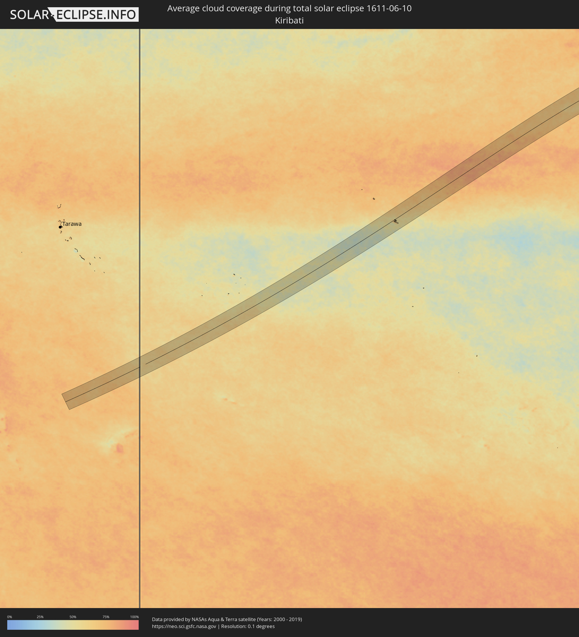 Kiribati
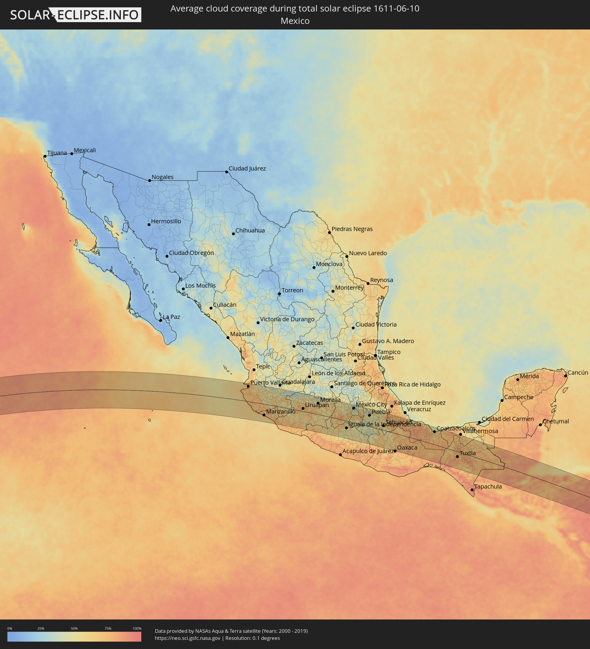 Mexico
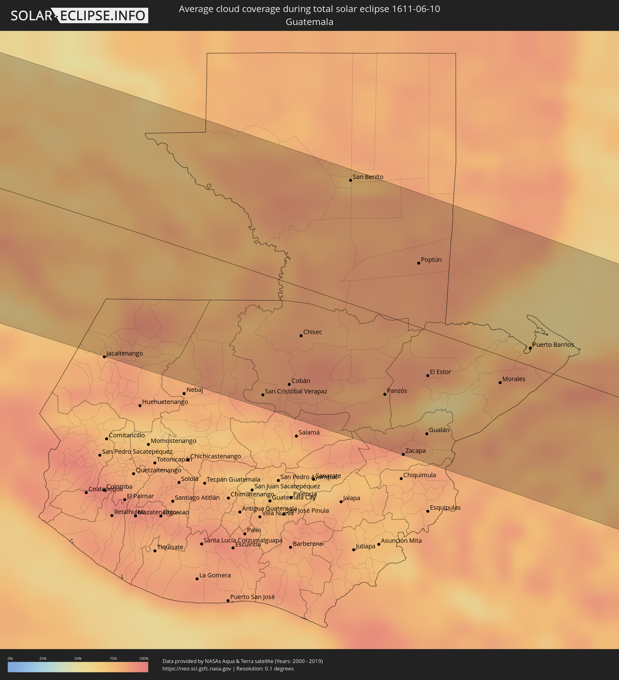 Guatemala
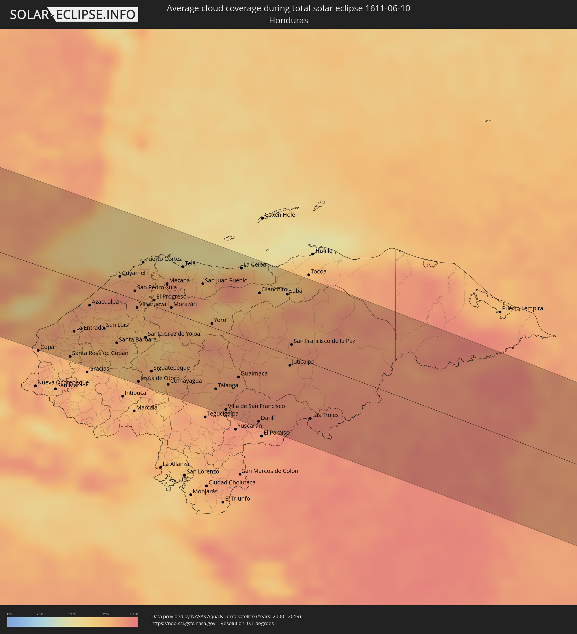 Honduras
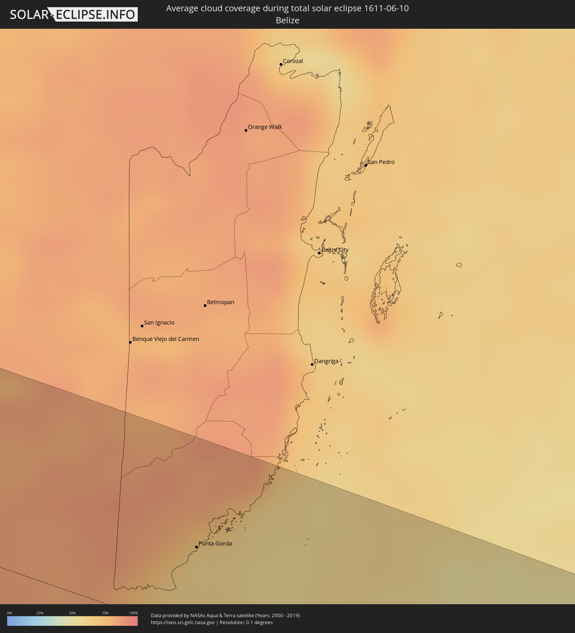 Belize
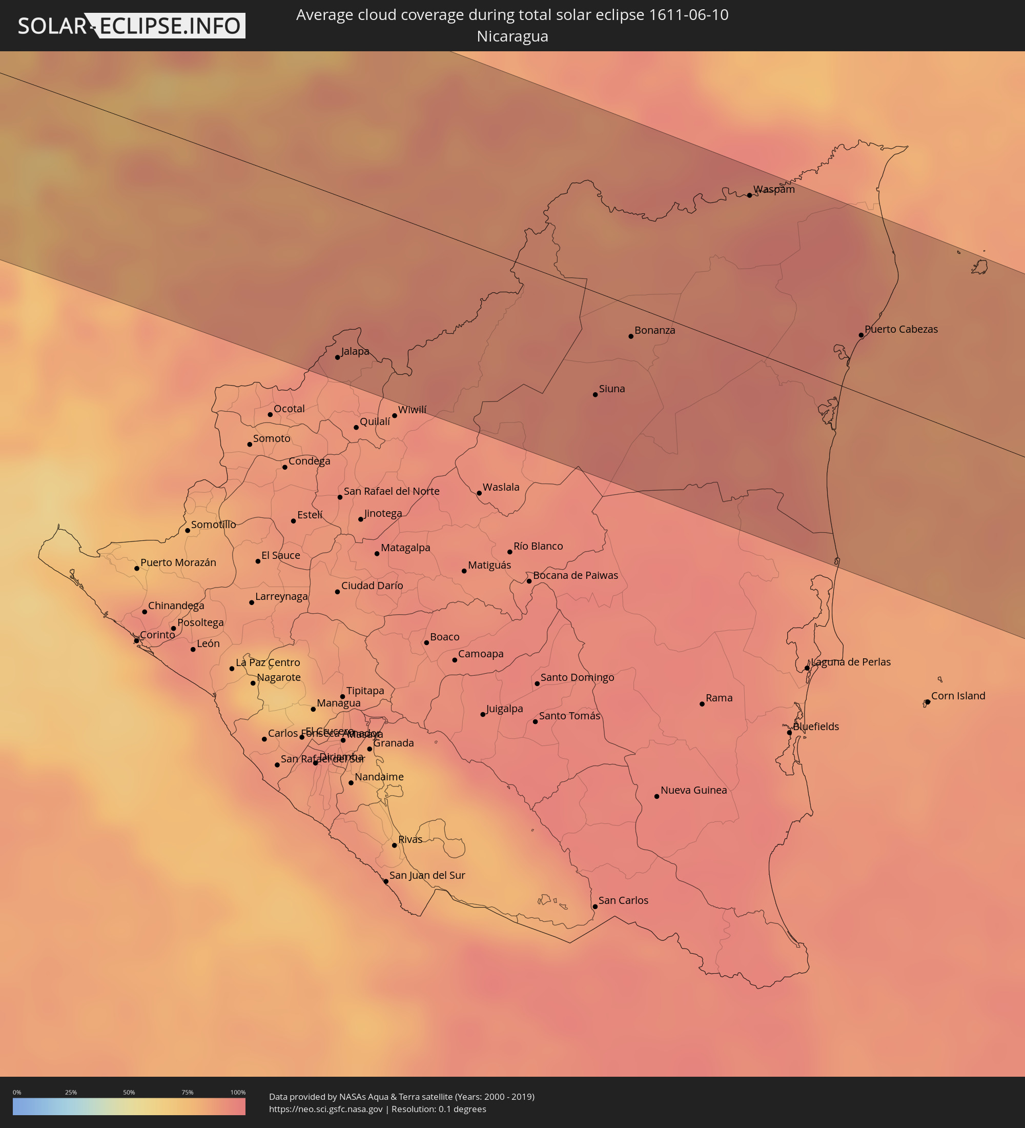 Nicaragua
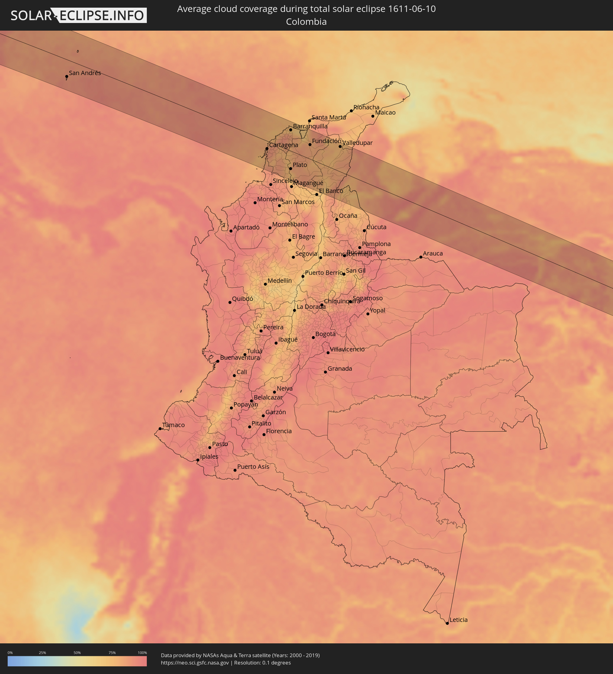 Colombia
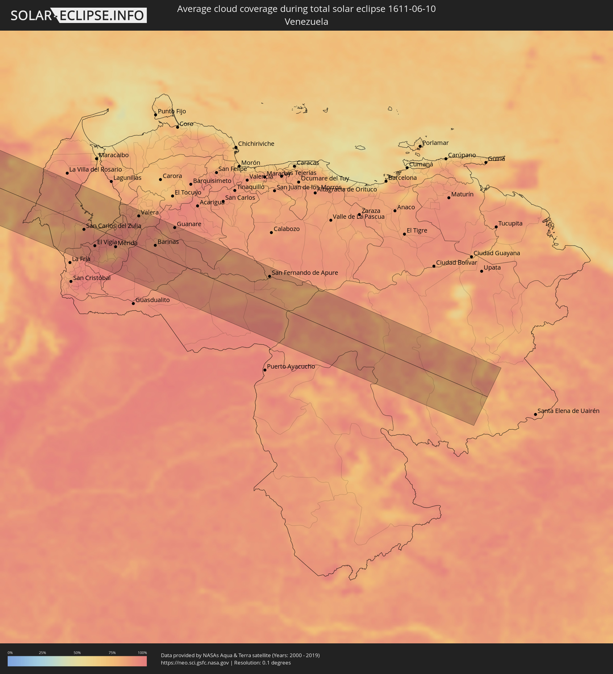 Venezuela
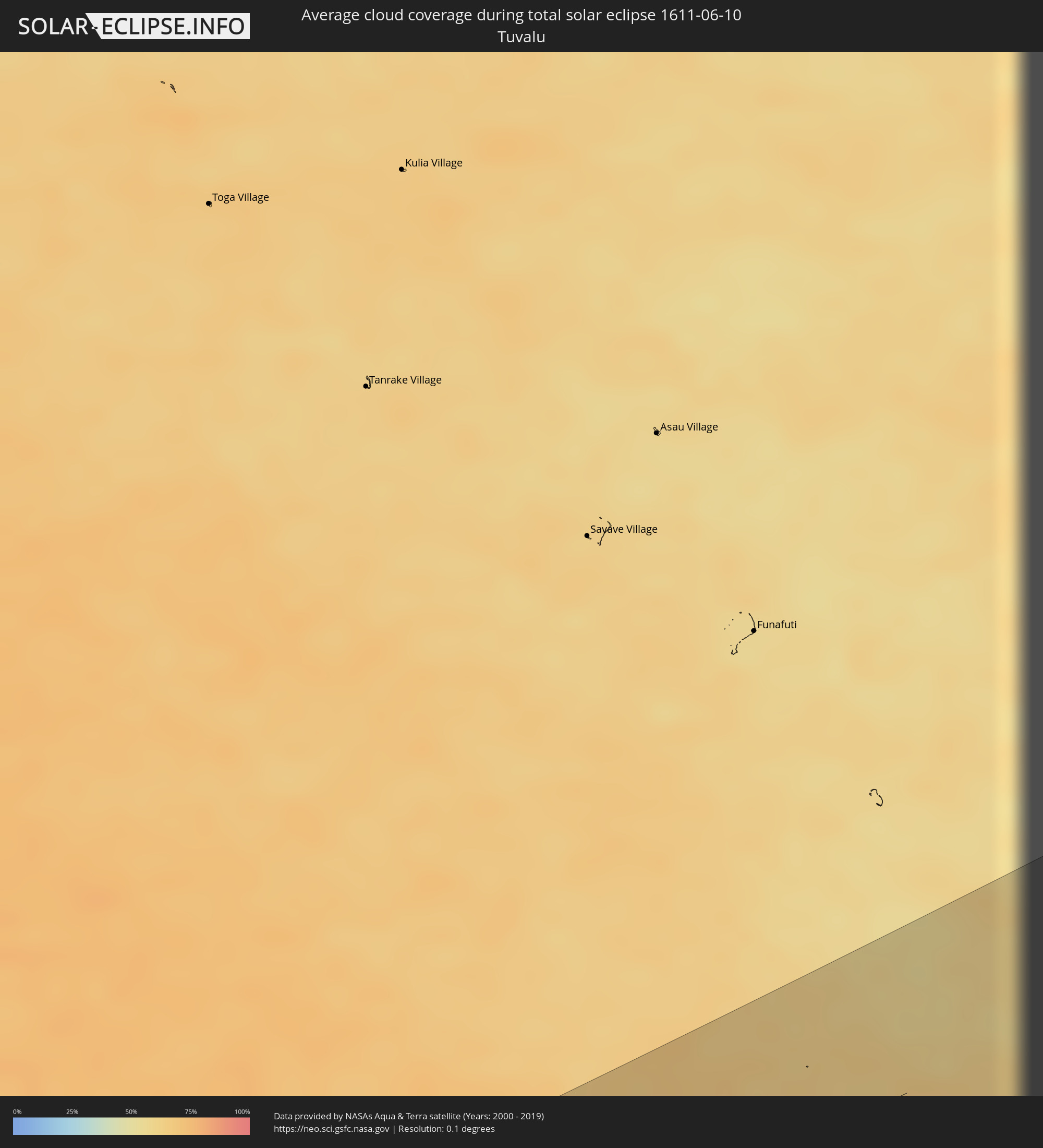 Tuvalu
Cities inside the path of the eclipse
The following table shows all locations with a population of more than 5,000 inside the eclipse path. Cities which have more than 100,000 inhabitants are marked bold. A click at the locations opens a detailed map.
| City | Type | Eclipse duration | Local time of max. eclipse | Distance to central line | Ø Cloud coverage |
|
Puerto Vallarta, Jalisco
|
total | - | 14:55:53 UTC-06:36 | 89 km | 74% |
|
Manzanillo, Colima
|
total | - | 14:58:14 UTC-06:36 | 67 km | 72% |
|
Colima, Colima
|
total | - | 14:59:22 UTC-06:36 | 35 km | 63% |
|
Zamora, Michoacán
|
total | - | 15:01:57 UTC-06:36 | 74 km | 45% |
|
Uruapan, Michoacán
|
total | - | 15:02:36 UTC-06:36 | 16 km | 65% |
|
Morelia, Michoacán
|
total | - | 15:04:07 UTC-06:36 | 66 km | 57% |
|
Toluca, México
|
total | - | 15:07:02 UTC-06:36 | 56 km | 53% |
|
Iguala de la Independencia, Guerrero
|
total | - | 15:07:37 UTC-06:36 | 43 km | 51% |
|
Huixquilucan, México
|
total | - | 15:07:31 UTC-06:36 | 72 km | 63% |
|
Ciudad López Mateos, México
|
total | - | 15:07:35 UTC-06:36 | 98 km | 44% |
|
Cuernavaca, Morelos
|
total | - | 15:07:55 UTC-06:36 | 28 km | 53% |
|
Tlalpan, Mexico City
|
total | - | 15:07:52 UTC-06:36 | 69 km | 50% |
|
Mexico City, Mexico City
|
total | - | 15:07:53 UTC-06:36 | 84 km | 43% |
|
Santa María Chimalhuacán, México
|
total | - | 15:08:11 UTC-06:36 | 88 km | 43% |
|
Cuautla Morelos, Morelos
|
total | - | 15:08:27 UTC-06:36 | 22 km | 50% |
|
San Miguel Xico Viejo, México
|
total | - | 15:08:16 UTC-06:36 | 72 km | 47% |
|
Puebla, Puebla
|
total | - | 15:09:36 UTC-06:36 | 66 km | 48% |
|
Tehuacán, Puebla
|
total | - | 15:11:11 UTC-06:36 | 25 km | 52% |
|
Orizaba, Veracruz
|
total | - | 15:11:28 UTC-06:36 | 75 km | 69% |
|
Córdoba, Veracruz
|
total | - | 15:11:43 UTC-06:36 | 83 km | 66% |
|
Minatitlan, Veracruz
|
total | - | 15:15:42 UTC-06:36 | 57 km | 69% |
|
Coatzacoalcos, Veracruz
|
total | - | 15:15:47 UTC-06:36 | 75 km | 66% |
|
Tuxtla, Chiapas
|
total | - | 15:18:17 UTC-06:36 | 31 km | 77% |
|
San Cristóbal de las Casas, Chiapas
|
total | - | 15:18:55 UTC-06:36 | 18 km | 85% |
|
Las Margaritas, Chiapas
|
total | - | 15:19:59 UTC-06:36 | 41 km | 69% |
|
San Mateo Ixtatán, Huehuetenango
|
total | - | 15:55:22 UTC-06:02 | 76 km | 80% |
|
Soloma, Huehuetenango
|
total | - | 15:55:27 UTC-06:02 | 87 km | 83% |
|
Barillas, Huehuetenango
|
total | - | 15:55:35 UTC-06:02 | 73 km | 75% |
|
San Luis Ixcán, Quiché
|
total | - | 15:55:52 UTC-06:02 | 67 km | 81% |
|
Chajul, Quiché
|
total | - | 15:56:05 UTC-06:02 | 97 km | 76% |
|
San Cristóbal Verapaz, Alta Verapaz
|
total | - | 15:56:41 UTC-06:02 | 91 km | 79% |
|
Cobán, Alta Verapaz
|
total | - | 15:56:53 UTC-06:02 | 76 km | 85% |
|
Tactic, Alta Verapaz
|
total | - | 15:56:58 UTC-06:02 | 91 km | 80% |
|
San Juan Chamelco, Alta Verapaz
|
total | - | 15:56:57 UTC-06:02 | 79 km | 88% |
|
Chisec, Alta Verapaz
|
total | - | 15:56:50 UTC-06:02 | 37 km | 83% |
|
San Pedro Carchá, Alta Verapaz
|
total | - | 15:57:00 UTC-06:02 | 71 km | 85% |
|
Sayaxché, Petén
|
total | - | 15:56:38 UTC-06:02 | 41 km | 77% |
|
La Libertad, Petén
|
total | - | 15:56:33 UTC-06:02 | 71 km | 81% |
|
San Benito, Petén
|
total | - | 15:56:43 UTC-06:02 | 92 km | 81% |
|
Santa Ana, Petén
|
total | - | 15:56:52 UTC-06:02 | 82 km | 81% |
|
Panzós, Alta Verapaz
|
total | - | 15:57:44 UTC-06:02 | 59 km | 73% |
|
Estanzuela, Zacapa
|
total | - | 15:58:02 UTC-06:02 | 98 km | 76% |
|
Zacapa, Zacapa
|
total | - | 15:58:05 UTC-06:02 | 99 km | 79% |
|
Poptún, Petén
|
total | - | 15:57:35 UTC-06:02 | 47 km | 84% |
|
Dolores, Petén
|
total | - | 15:57:29 UTC-06:02 | 67 km | 85% |
|
Gualán, Zacapa
|
total | - | 15:58:13 UTC-06:02 | 78 km | 77% |
|
El Estor, Izabal
|
total | - | 15:58:02 UTC-06:02 | 34 km | 62% |
|
Morales, Izabal
|
total | - | 15:58:39 UTC-06:02 | 21 km | 76% |
|
Punta Gorda, Toledo
|
total | - | 16:07:38 UTC-05:52 | 44 km | 60% |
|
Santa Rosa de Copán, Copán
|
total | - | 16:12:13 UTC-05:48 | 95 km | 76% |
|
Lívingston, Izabal
|
total | - | 15:58:33 UTC-06:02 | 18 km | 75% |
|
La Entrada, Copán
|
total | - | 16:12:09 UTC-05:48 | 63 km | 80% |
|
Puerto Barrios, Izabal
|
total | - | 15:58:47 UTC-06:02 | 13 km | 82% |
|
Santa Bárbara, Santa Bárbara
|
total | - | 16:12:44 UTC-05:48 | 59 km | 77% |
|
Cofradía, Cortés
|
total | - | 16:12:36 UTC-05:48 | 6 km | 77% |
|
San Pedro Sula, Cortés
|
total | - | 16:12:41 UTC-05:48 | 10 km | 81% |
|
Villanueva, Cortés
|
total | - | 16:12:48 UTC-05:48 | 9 km | 74% |
|
Pimienta Vieja, Cortés
|
total | - | 16:12:52 UTC-05:48 | 16 km | 73% |
|
Puerto Cortez, Cortés
|
total | - | 16:12:38 UTC-05:48 | 47 km | 77% |
|
Santa Cruz de Yojoa, Cortés
|
total | - | 16:13:04 UTC-05:48 | 40 km | 71% |
|
Baracoa, Cortés
|
total | - | 16:12:45 UTC-05:48 | 44 km | 77% |
|
Siguatepeque, Comayagua
|
total | - | 16:13:18 UTC-05:48 | 78 km | 76% |
|
El Progreso, Yoro
|
total | - | 16:12:58 UTC-05:48 | 7 km | 80% |
|
El Negrito, Yoro
|
total | - | 16:13:07 UTC-05:48 | 2 km | 78% |
|
Comayagua, Comayagua
|
total | - | 16:13:34 UTC-05:48 | 86 km | 78% |
|
Morazán, Yoro
|
total | - | 16:13:13 UTC-05:48 | 6 km | 80% |
|
Tela, Atlántida
|
total | - | 16:13:08 UTC-05:48 | 58 km | 69% |
|
Santa Rita, Yoro
|
total | - | 16:13:36 UTC-05:48 | 1 km | 74% |
|
Yoro, Yoro
|
total | - | 16:13:46 UTC-05:48 | 4 km | 85% |
|
Talanga, Francisco Morazán
|
total | - | 16:14:09 UTC-05:48 | 71 km | 80% |
|
Guaimaca, Francisco Morazán
|
total | - | 16:14:22 UTC-05:48 | 48 km | 86% |
|
La Ceiba, Atlántida
|
total | - | 16:13:49 UTC-05:48 | 82 km | 77% |
|
Danlí, El Paraíso
|
total | - | 16:14:49 UTC-05:48 | 91 km | 85% |
|
Olanchito, Yoro
|
total | - | 16:14:09 UTC-05:48 | 60 km | 74% |
|
Sabá, Colón
|
total | - | 16:14:28 UTC-05:48 | 71 km | 77% |
|
Juticalpa, Olancho
|
total | - | 16:14:53 UTC-05:48 | 12 km | 83% |
|
Jalapa, Nueva Segovia
|
total | - | 16:18:58 UTC-05:45 | 86 km | 89% |
|
Siuna, Atlántico Norte (RAAN)
|
total | - | 16:20:16 UTC-05:45 | 54 km | 92% |
|
Bonanza, Atlántico Norte (RAAN)
|
total | - | 16:20:18 UTC-05:45 | 17 km | 92% |
|
Waspam, Atlántico Norte (RAAN)
|
total | - | 16:20:30 UTC-05:45 | 81 km | 92% |
|
Puerto Cabezas, Atlántico Norte (RAAN)
|
total | - | 16:21:17 UTC-05:45 | 30 km | 83% |
|
San Andrés, Archipiélago de San Andrés, Providencia y Santa Catalina
|
total | - | 17:12:07 UTC-04:56 | 53 km | 88% |
|
Cartagena, Bolívar
|
total | - | 17:16:25 UTC-04:56 | 24 km | 87% |
|
Arjona, Bolívar
|
total | - | 17:16:32 UTC-04:56 | 32 km | 80% |
|
María la Baja, Bolívar
|
total | - | 17:16:39 UTC-04:56 | 58 km | 82% |
|
Repelón, Atlántico
|
total | - | 17:16:33 UTC-04:56 | 1 km | 77% |
|
El Carmen de Bolívar, Bolívar
|
total | - | 17:16:49 UTC-04:56 | 78 km | 82% |
|
San Juan Nepomuceno, Bolívar
|
total | - | 17:16:45 UTC-04:56 | 52 km | 86% |
|
Puerto Colombia, Atlántico
|
total | - | 17:16:26 UTC-04:56 | 60 km | 82% |
|
Sabanalarga, Atlántico
|
total | - | 17:16:35 UTC-04:56 | 24 km | 85% |
|
Baranoa, Atlántico
|
total | - | 17:16:32 UTC-04:56 | 41 km | 86% |
|
Campo de la Cruz, Atlántico
|
total | - | 17:16:41 UTC-04:56 | 0 km | 75% |
|
Plato, Magdalena
|
total | - | 17:16:55 UTC-04:56 | 56 km | 73% |
|
Barranquilla, Atlántico
|
total | - | 17:16:31 UTC-04:56 | 65 km | 83% |
|
Palmar de Varela, Atlántico
|
total | - | 17:16:36 UTC-04:56 | 43 km | 82% |
|
Pivijay, Magdalena
|
total | - | 17:16:46 UTC-04:56 | 20 km | 85% |
|
Ciénaga, Magdalena
|
total | - | 17:16:42 UTC-04:56 | 92 km | 80% |
|
Fundación, Magdalena
|
total | - | 17:16:54 UTC-04:56 | 44 km | 83% |
|
Ariguaní, Cesar
|
total | - | 17:17:04 UTC-04:56 | 24 km | 79% |
|
Chimichagua, Cesar
|
total | - | 17:17:27 UTC-04:56 | 69 km | 71% |
|
Chiriguaná, Cesar
|
total | - | 17:17:29 UTC-04:56 | 50 km | 76% |
|
Curumaní, Cesar
|
total | - | 17:17:33 UTC-04:56 | 64 km | 85% |
|
La Jagua de Ibirico, Cesar
|
total | - | 17:17:31 UTC-04:56 | 18 km | 85% |
|
Valledupar, Cesar
|
total | - | 17:17:15 UTC-04:56 | 78 km | 75% |
|
Agustín Codazzi, Cesar
|
total | - | 17:17:23 UTC-04:56 | 35 km | 83% |
|
Tibú, Norte de Santander
|
total | - | 17:17:59 UTC-04:56 | 87 km | 74% |
|
Machiques, Zulia
|
total | - | 17:46:12 UTC-04:27 | 67 km | 84% |
|
San Carlos del Zulia, Zulia
|
total | - | 17:46:43 UTC-04:27 | 15 km | 91% |
|
El Vigía, Mérida
|
total | - | 17:46:53 UTC-04:27 | 43 km | 92% |
|
Ejido, Mérida
|
total | - | 17:47:01 UTC-04:27 | 32 km | 77% |
|
Mérida, Mérida
|
total | - | 17:47:01 UTC-04:27 | 24 km | 81% |
|
Mucumpiz, Mérida
|
total | - | 17:47:05 UTC-04:27 | 41 km | 92% |
|
Valera, Trujillo
|
total | - | 17:46:56 UTC-04:27 | 74 km | 88% |
|
Trujillo, Trujillo
|
total | - | 17:46:58 UTC-04:27 | 87 km | 83% |
|
Barinitas, Barinas
|
total | - | 17:47:09 UTC-04:27 | 26 km | 88% |
|
Alto Barinas, Barinas
|
total | - | 17:47:14 UTC-04:27 | 17 km | 90% |
|
Barinas, Barinas
|
total | - | 17:47:14 UTC-04:27 | 20 km | 90% |
|
Guanare, Portuguesa
|
total | - | 17:47:12 UTC-04:27 | 83 km | 91% |
|
San Fernando de Apure, Apure
|
total | - | 17:47:51 UTC-04:27 | 64 km | 85% |
|
Ahau, Rotuma
|
total | - | 06:45:05 UTC+11:55 | 18 km | 70% |