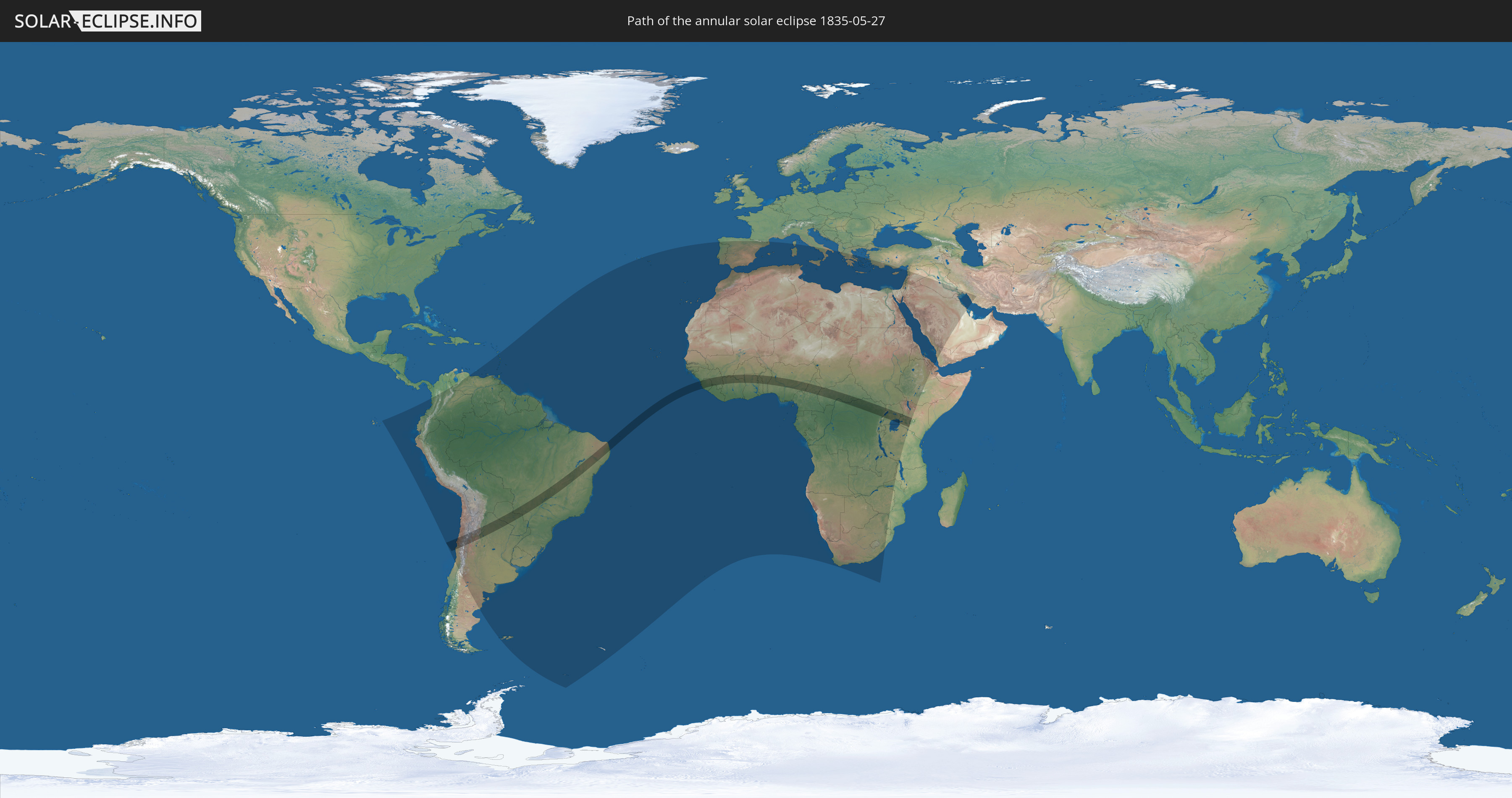
Annular solar eclipse of 05/27/1835
| Day of week: | Wednesday |
| Maximum duration of eclipse: | 06m44s |
| Maximum width of eclipse path: | 196 km |
| Saros cycle: | 125 |
| Coverage: | 94.9% |
| Magnitude: | 0.9486 |
| Gamma: | -0.2846 |
Wo kann man die Sonnenfinsternis vom 05/27/1835 sehen?
Die Sonnenfinsternis am 05/27/1835 kann man in 92 Ländern als partielle Sonnenfinsternis beobachten.
Der Finsternispfad verläuft durch 20 Länder. Nur in diesen Ländern ist sie als annular Sonnenfinsternis zu sehen.
In den folgenden Ländern ist die Sonnenfinsternis annular zu sehen
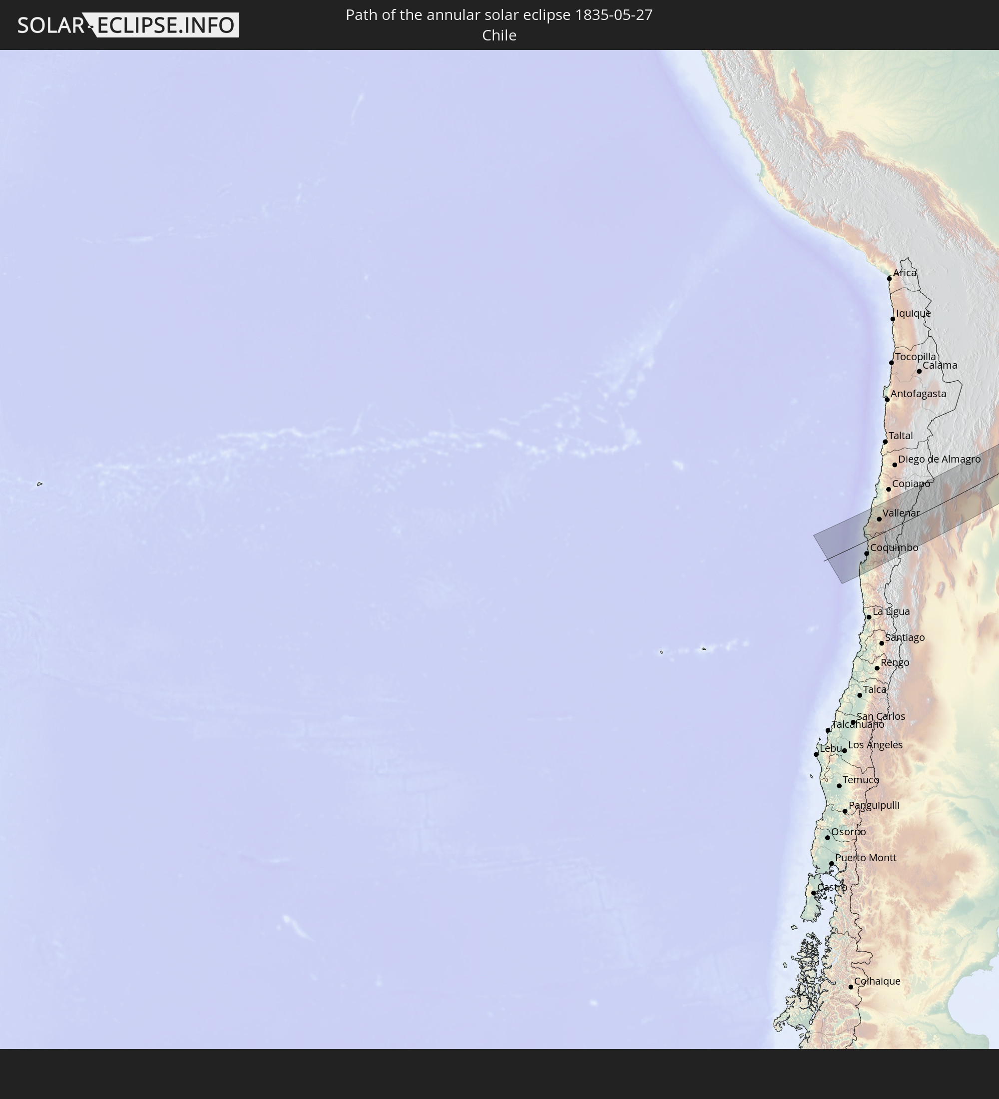 Chile
Chile
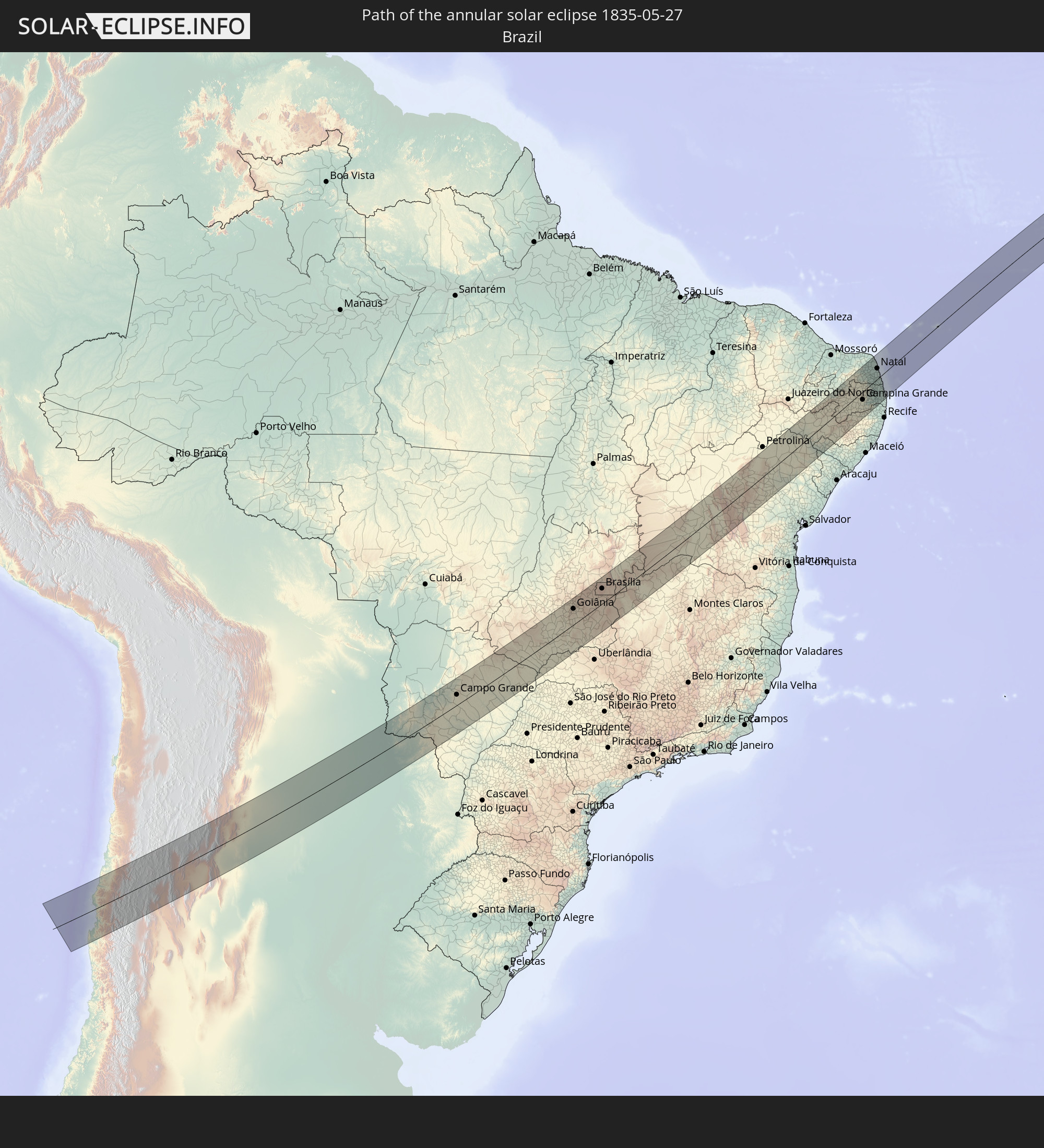 Brazil
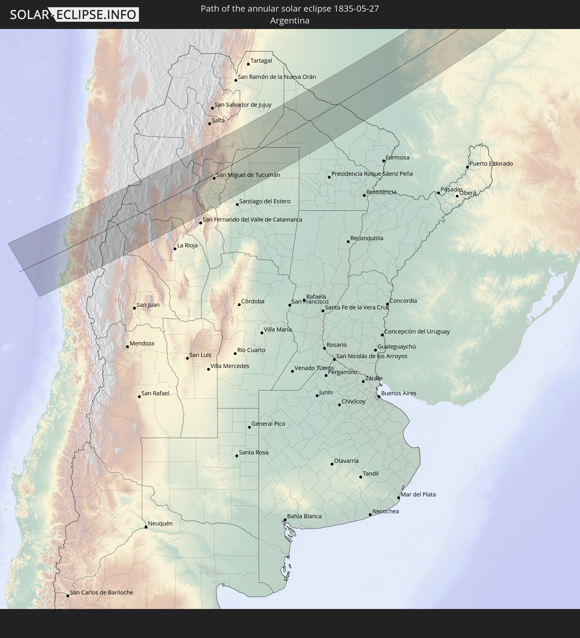 Argentina
 Paraguay
 Guinea
 Sierra Leone
 Mali
Mali
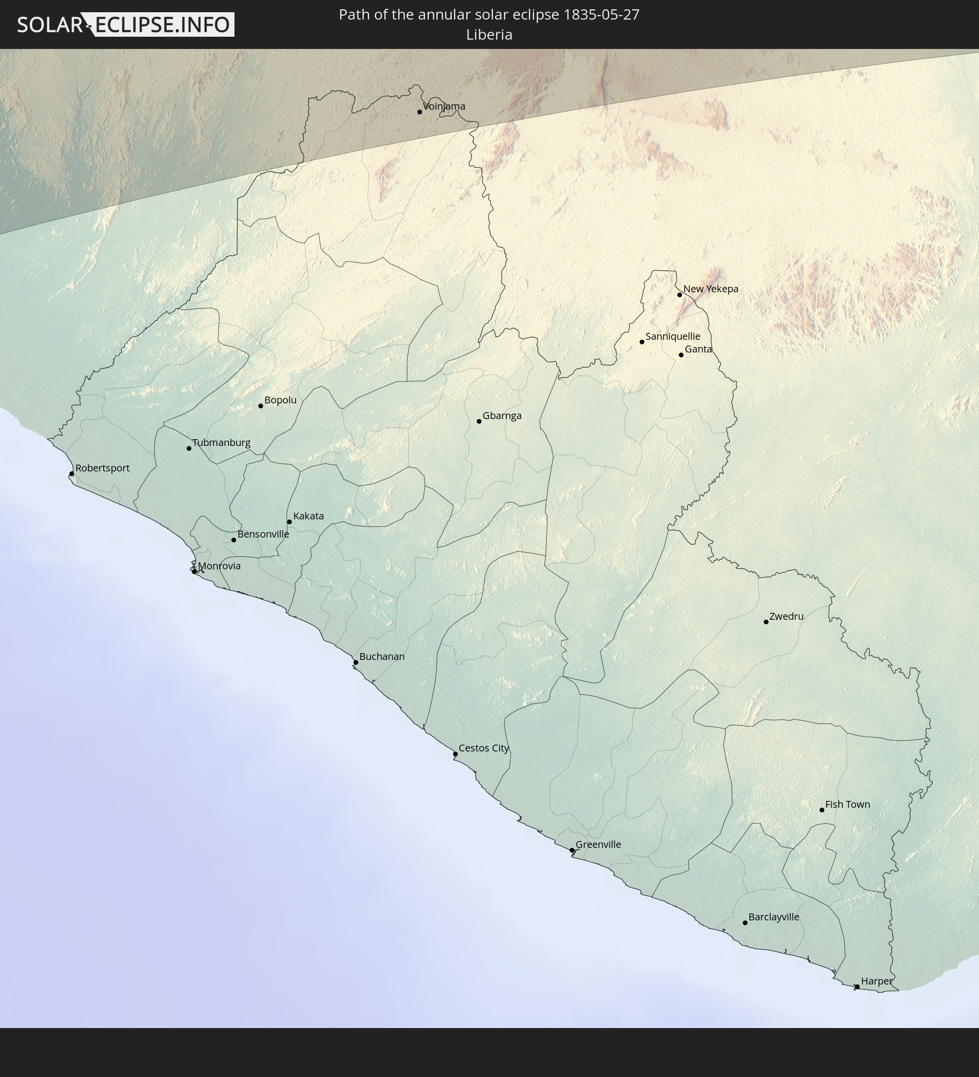 Liberia
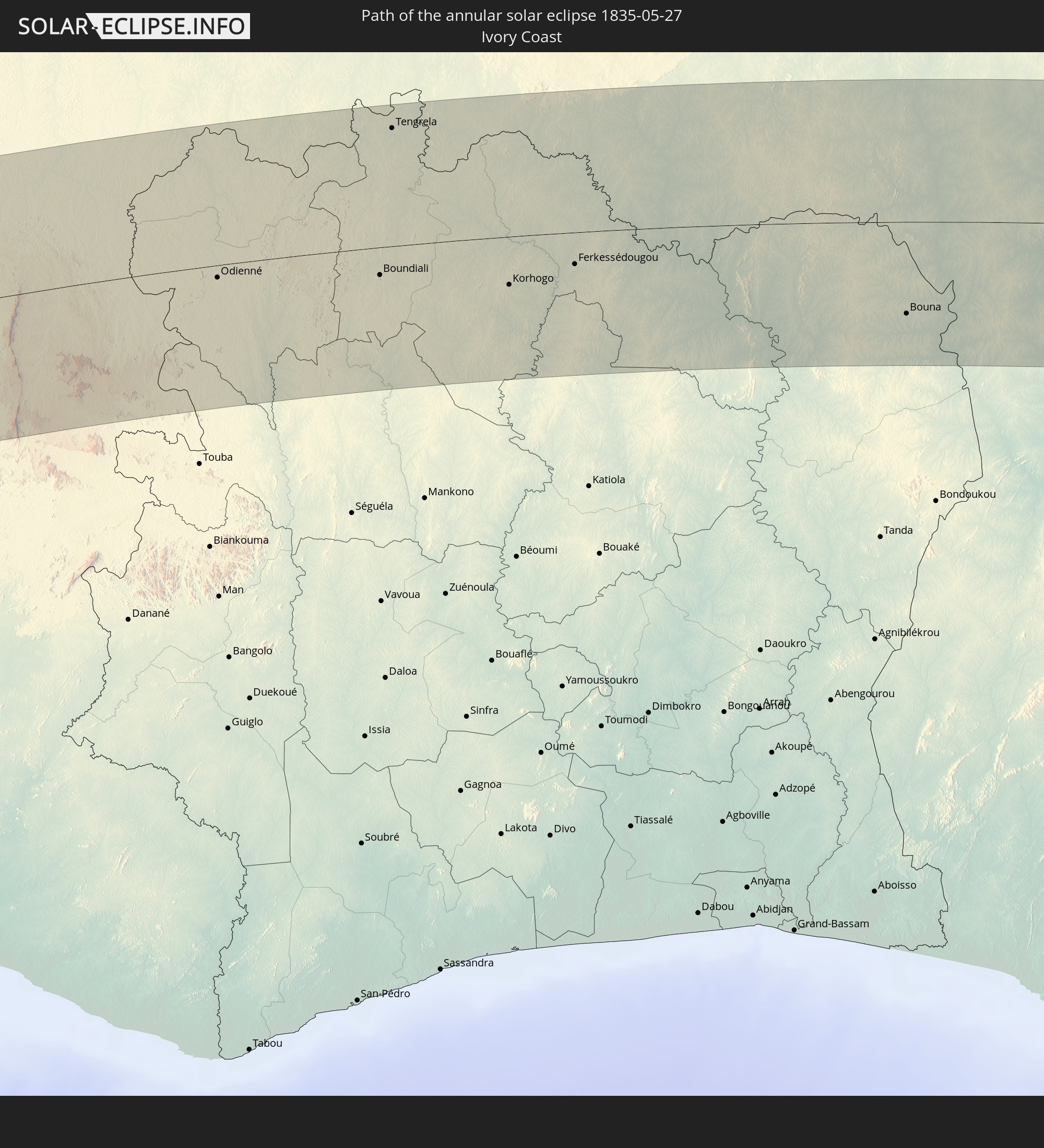 Ivory Coast
 Burkina Faso
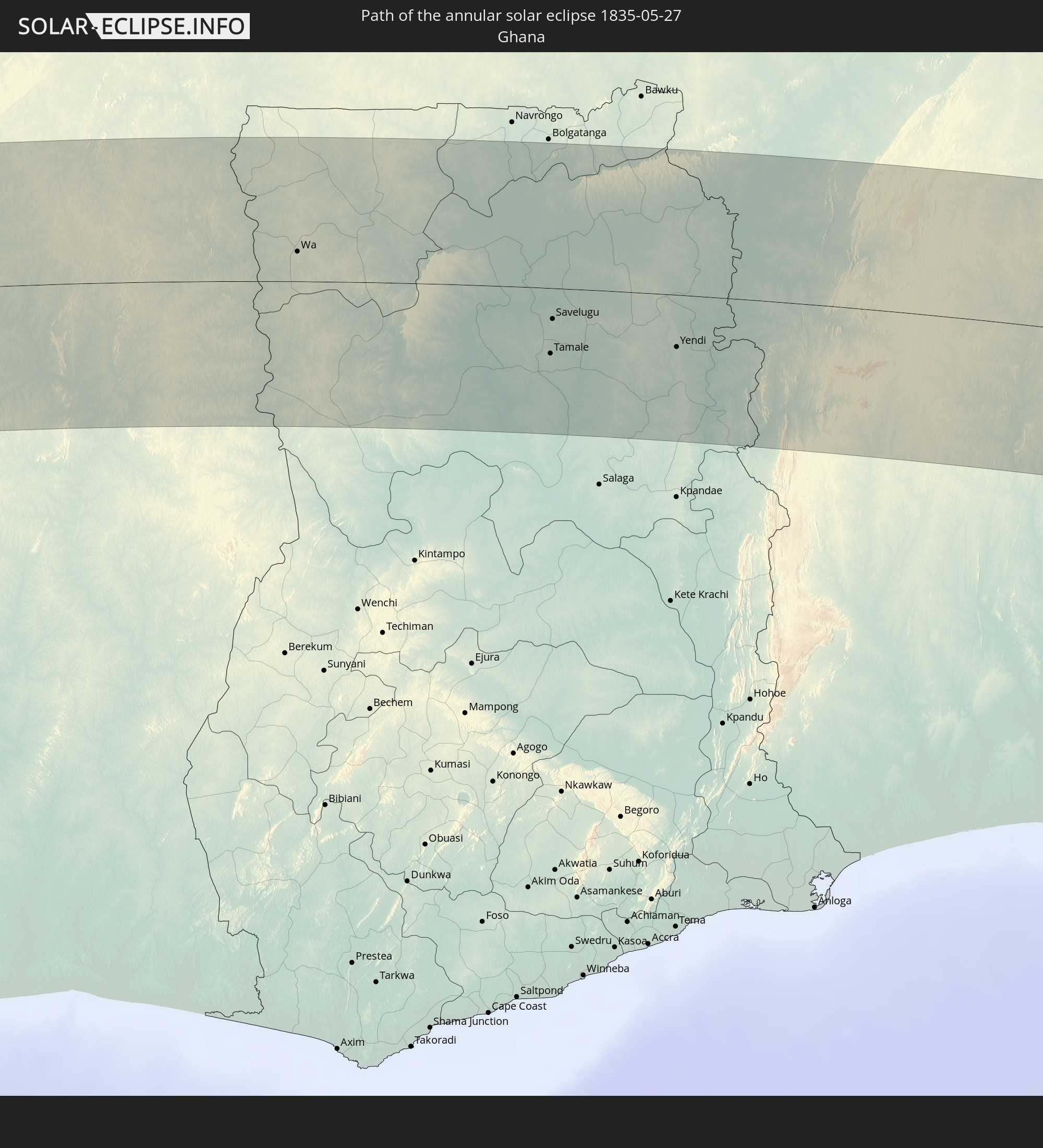 Ghana
Ghana
 Togo
Togo
 Benin
Benin
 Nigeria
 Cameroon
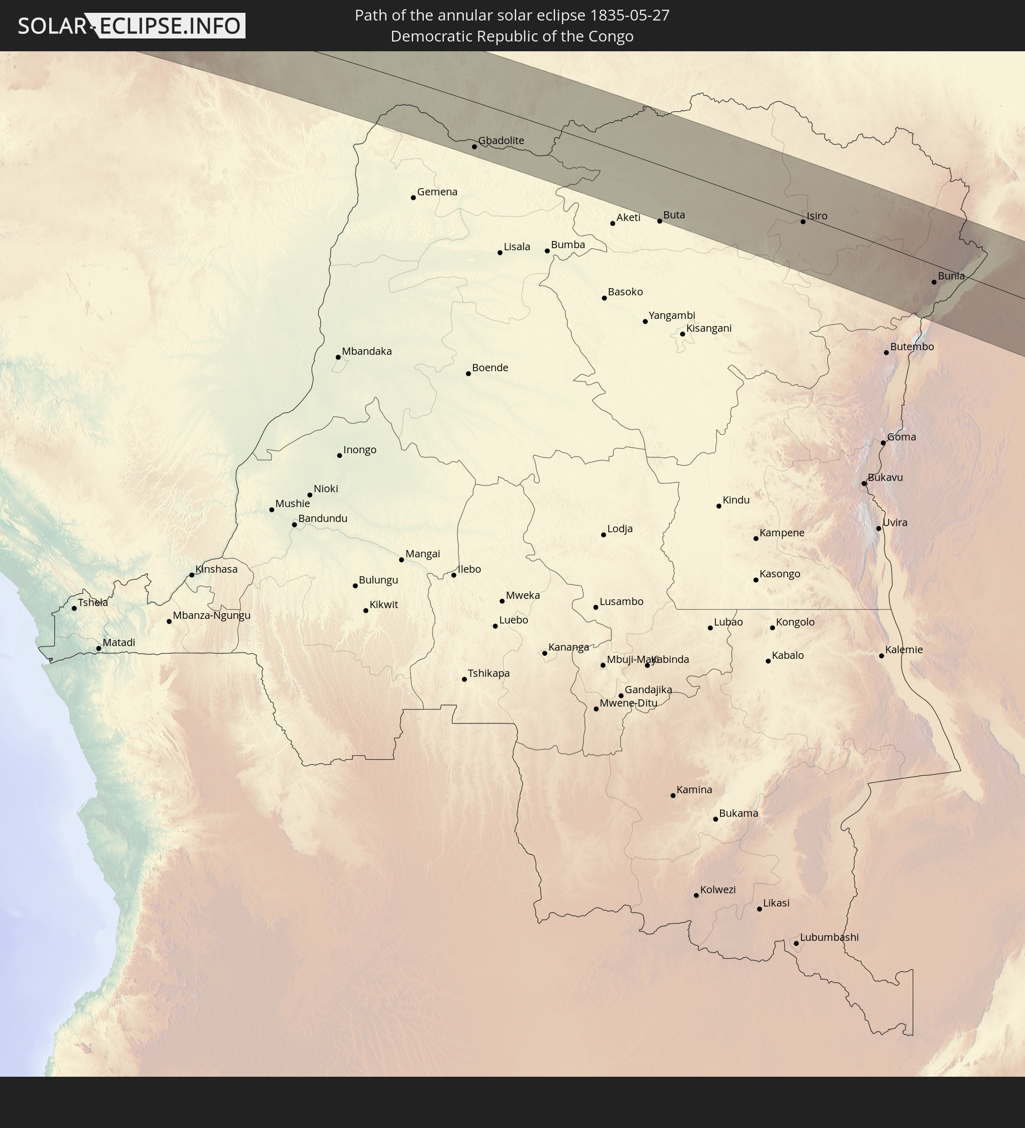 Democratic Republic of the Congo
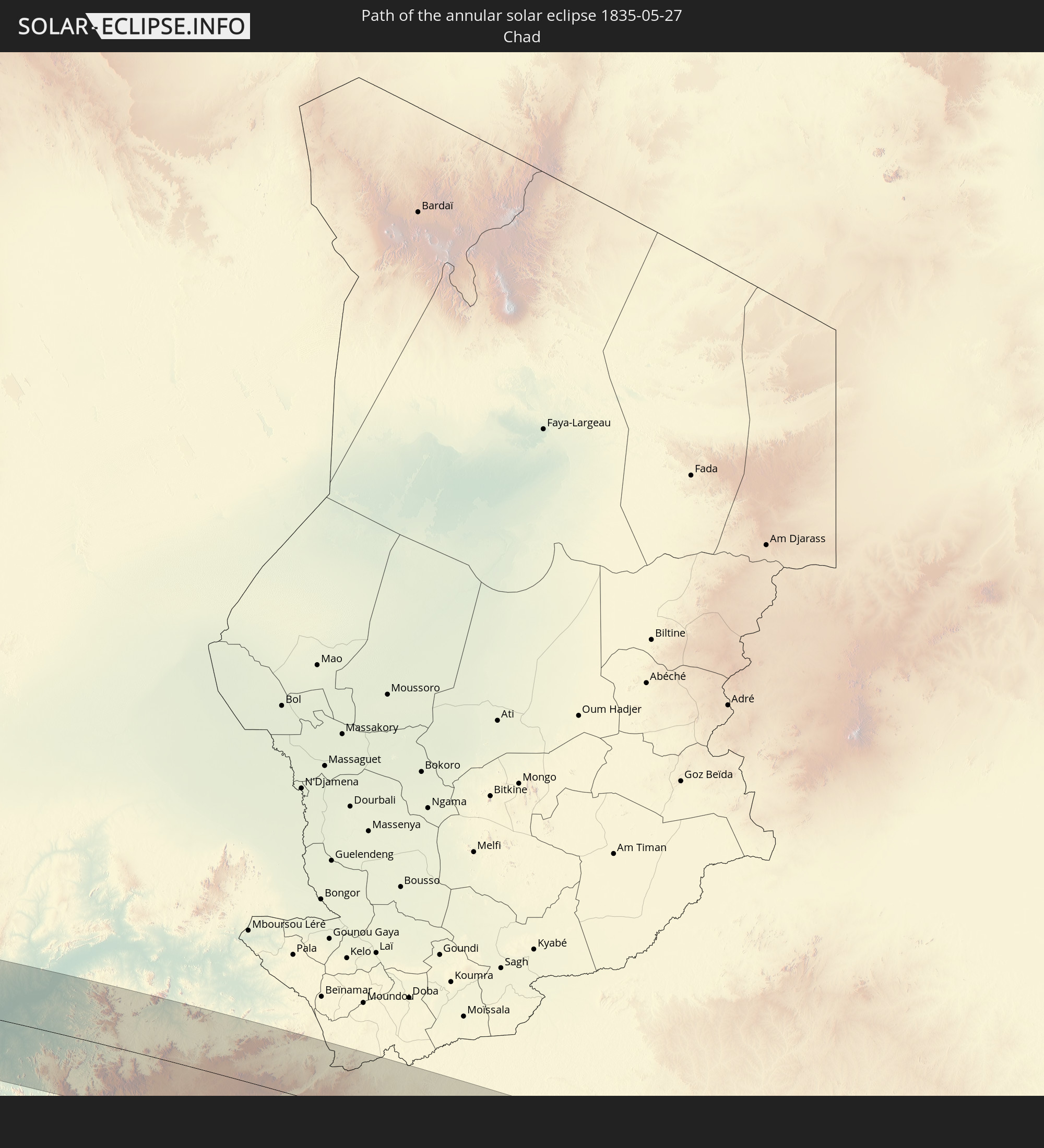 Chad
Chad
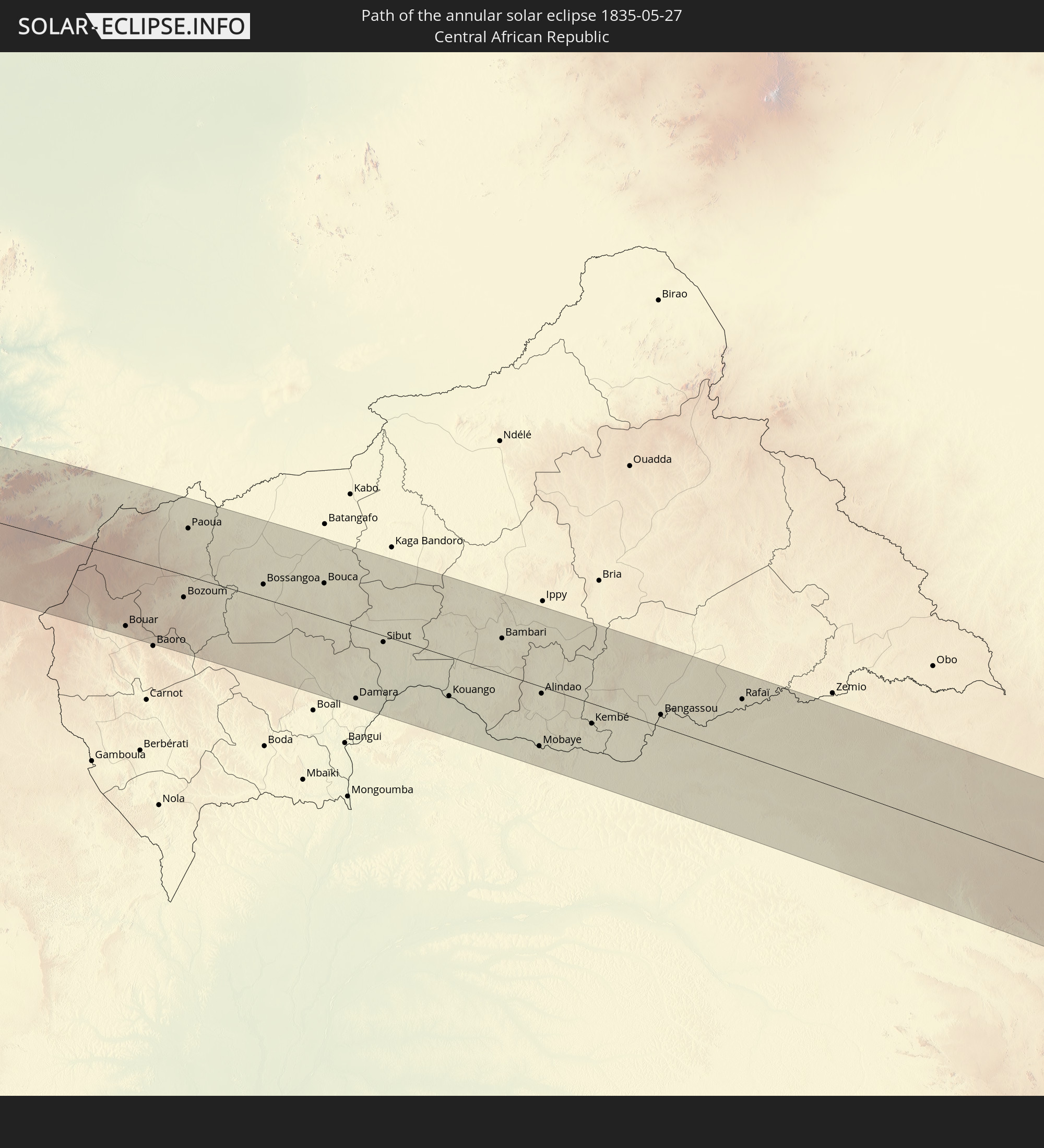 Central African Republic
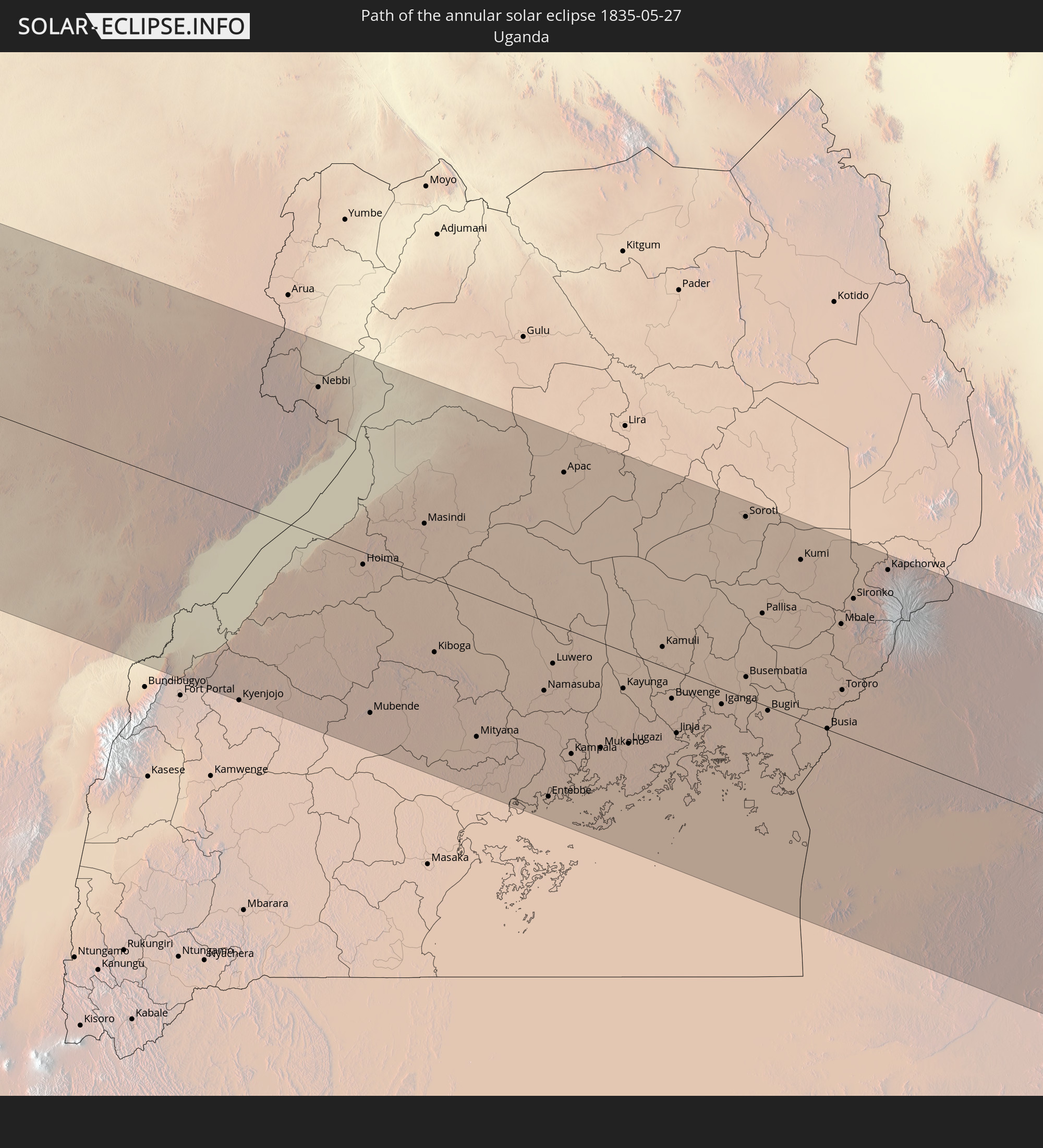 Uganda
 Kenya
Kenya
In den folgenden Ländern ist die Sonnenfinsternis partiell zu sehen
 Antarctica
 Chile
Chile
 Ecuador
 Colombia
 Peru
Peru
 Brazil
 Argentina
 Venezuela
 Bolivia
 Paraguay
 Trinidad and Tobago
 Grenada
 Dominica
 Saint Vincent and the Grenadines
 Falkland Islands
 Guyana
 Martinique
 Saint Lucia
 Barbados
 Uruguay
 Suriname
 French Guiana
 South Georgia and the South Sandwich Islands
 Portugal
 Cabo Verde
 Spain
Spain
 Senegal
 Mauritania
 The Gambia
 Guinea-Bissau
 Guinea
 Saint Helena, Ascension and Tristan da Cunha
 Sierra Leone
 Morocco
 Mali
Mali
 Liberia
 Algeria
 Ivory Coast
 Burkina Faso
 Gibraltar
 France
 Ghana
Ghana
 Togo
Togo
 Niger
Niger
 Benin
Benin
 Andorra
 Nigeria
 Equatorial Guinea
 São Tomé and Príncipe
 Italy
Italy
 Tunisia
 Cameroon
 Gabon
Gabon
 Libya
Libya
 Republic of the Congo
 Angola
 Namibia
 Democratic Republic of the Congo
 Chad
Chad
 Malta
Malta
 Central African Republic
 South Africa
 Albania
 Greece
 Botswana
 Sudan
Sudan
 Zambia
 Egypt
Egypt
 Zimbabwe
 Turkey
 Lesotho
 Rwanda
 Burundi
 Tanzania
 Uganda
 Mozambique
 Swaziland
 Cyprus
 Malawi
 Ethiopia
 Kenya
Kenya
 State of Palestine
 Israel
 Saudi Arabia
 Jordan
 Lebanon
 Syria
Syria
 Eritrea
 Iraq
Iraq
 Yemen
Yemen
 Iran
Iran
 Kuwait
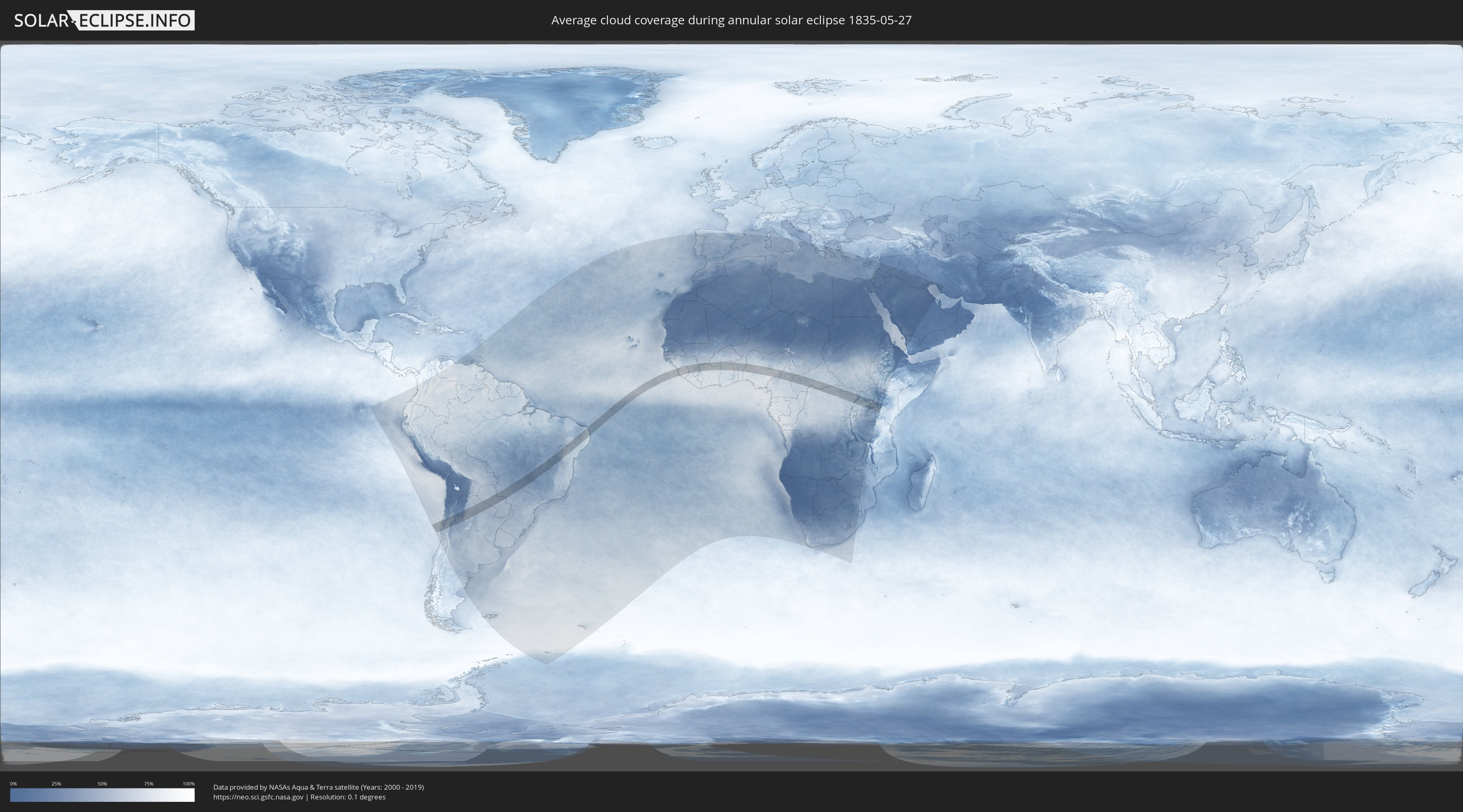
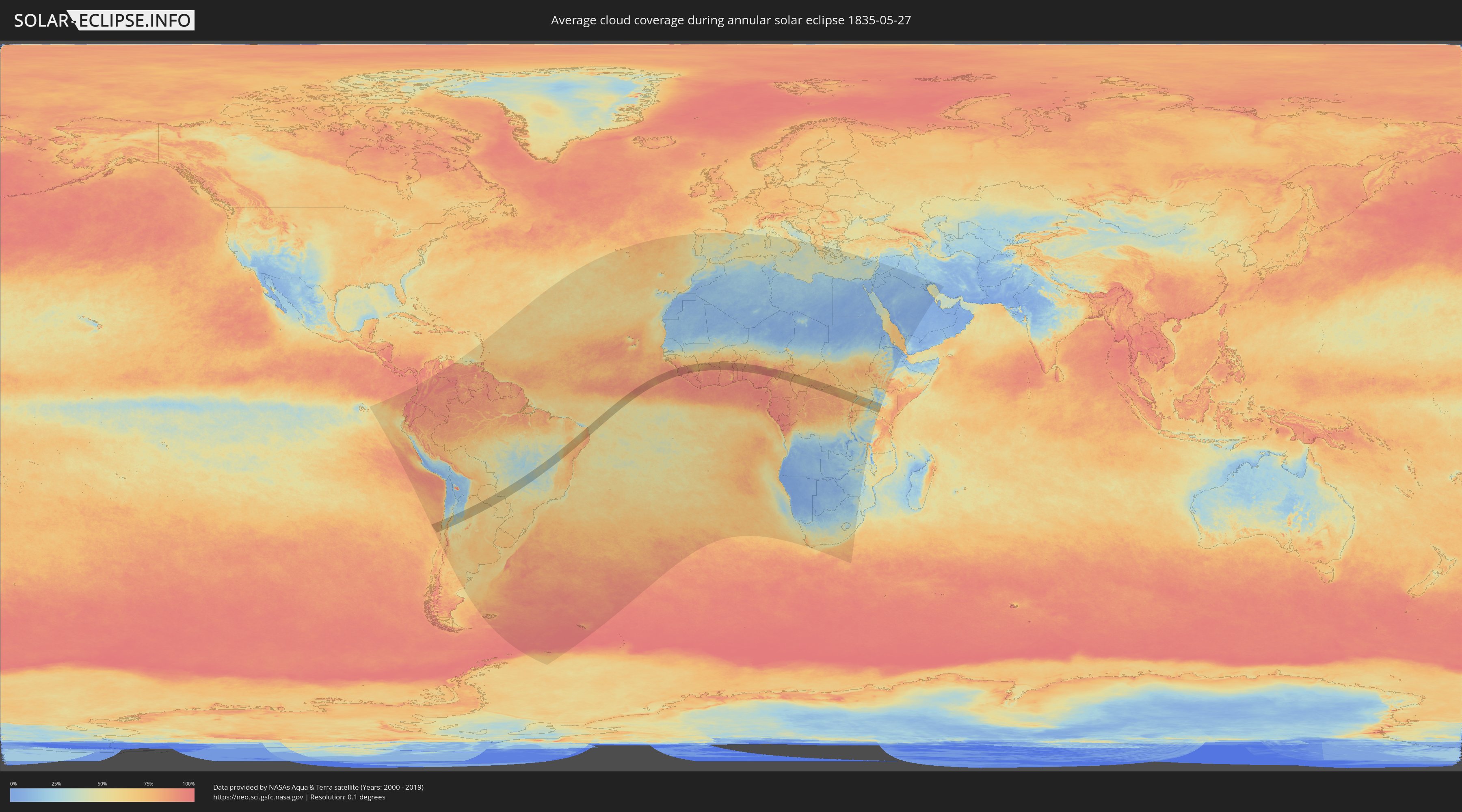
How will be the weather during the annular solar eclipse on 05/27/1835?
Where is the best place to see the annular solar eclipse of 05/27/1835?
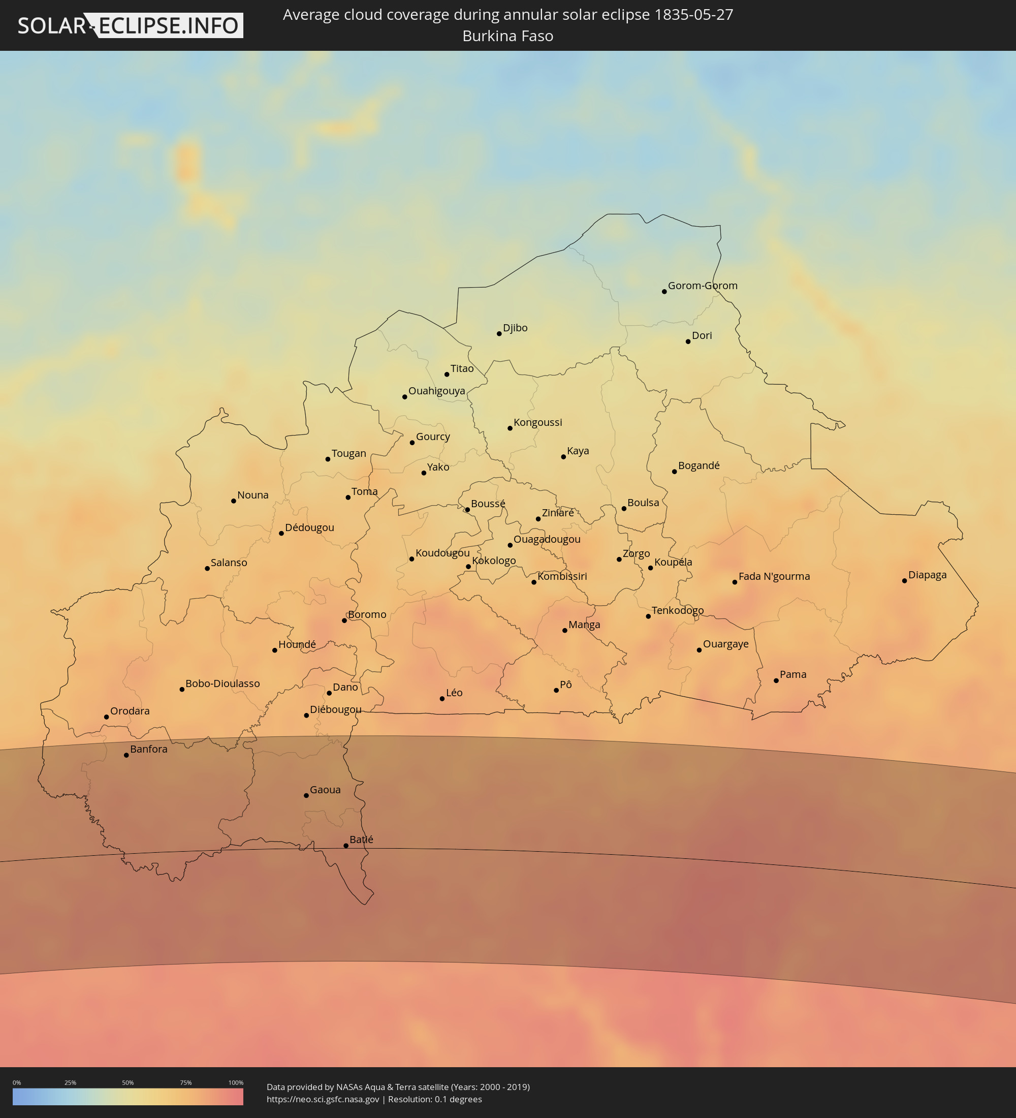
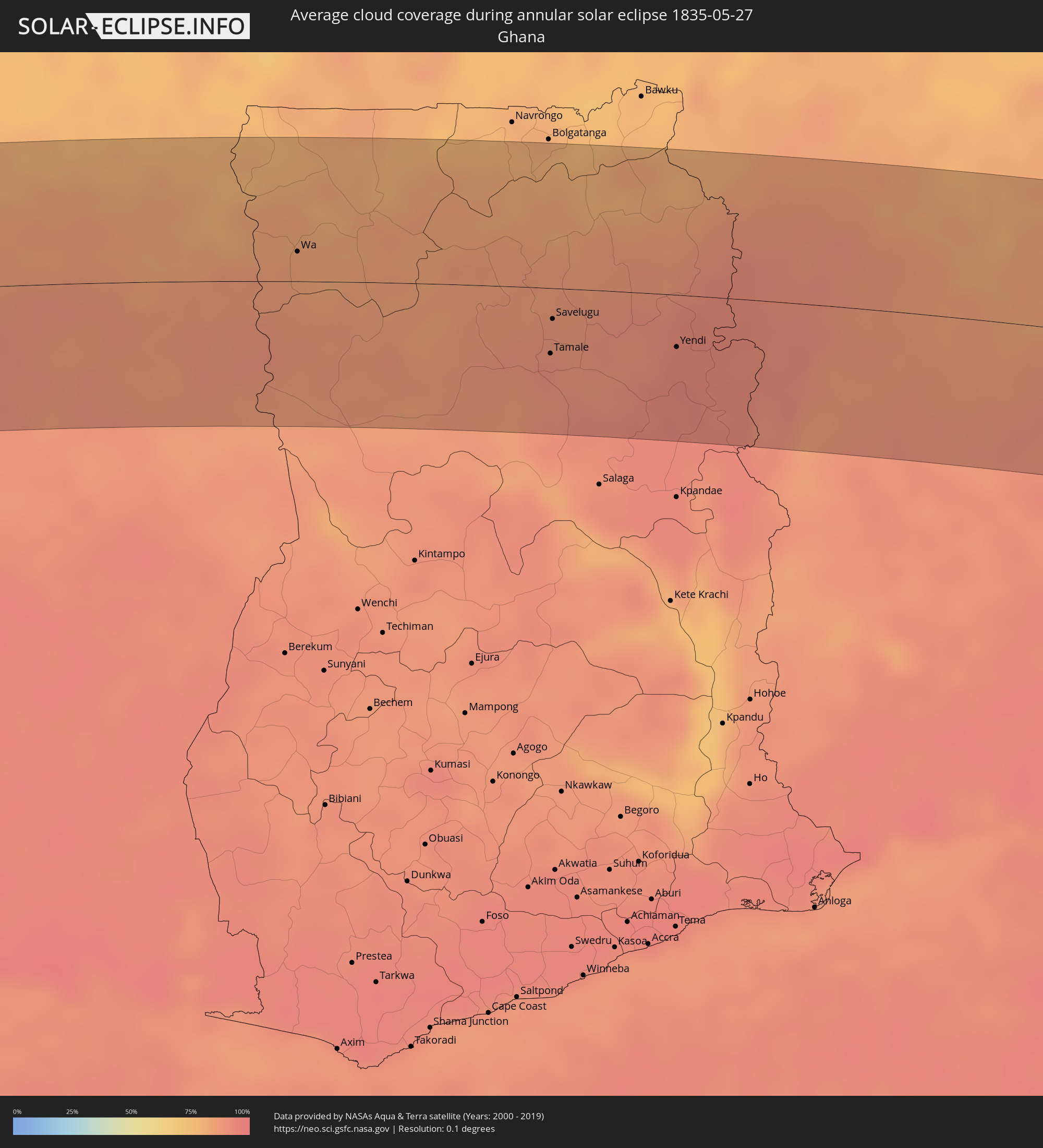
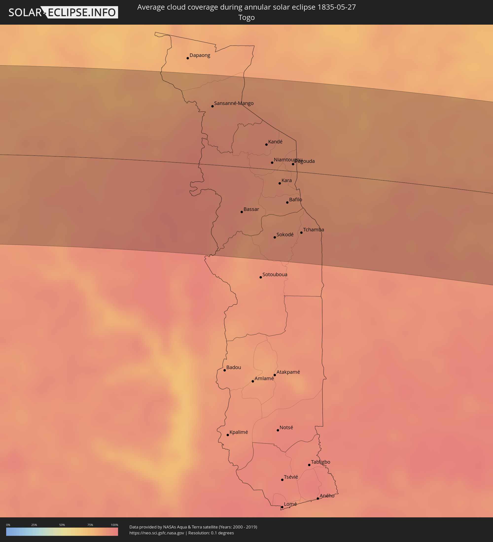
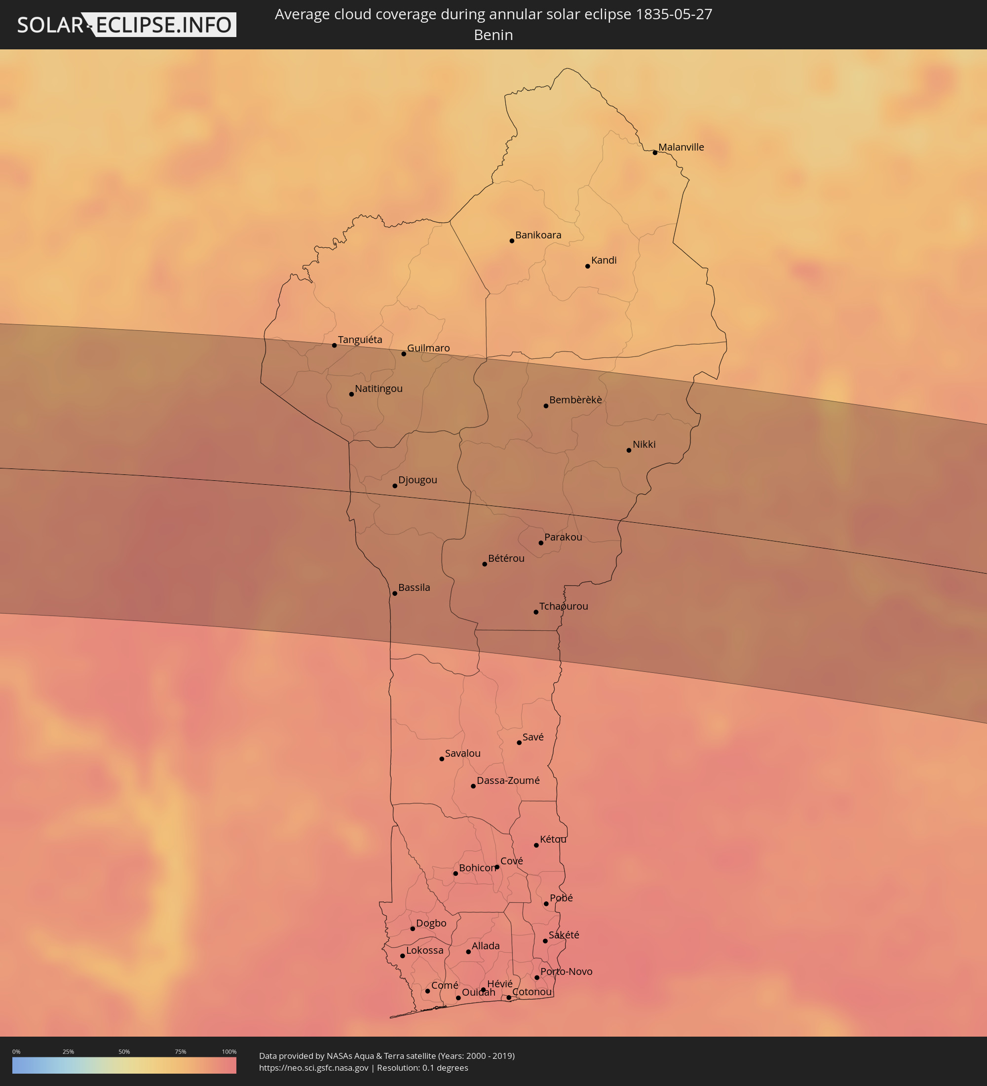
The following maps show the average cloud coverage for the day of the annular solar eclipse.
With the help of these maps, it is possible to find the place along the eclipse path, which has the best
chance of a cloudless sky.
Nevertheless, you should consider local circumstances and inform about the weather of your chosen
observation site.
The data is provided by NASAs satellites
AQUA and TERRA.
The cloud maps are averaged over a period of 19 years (2000 - 2019).
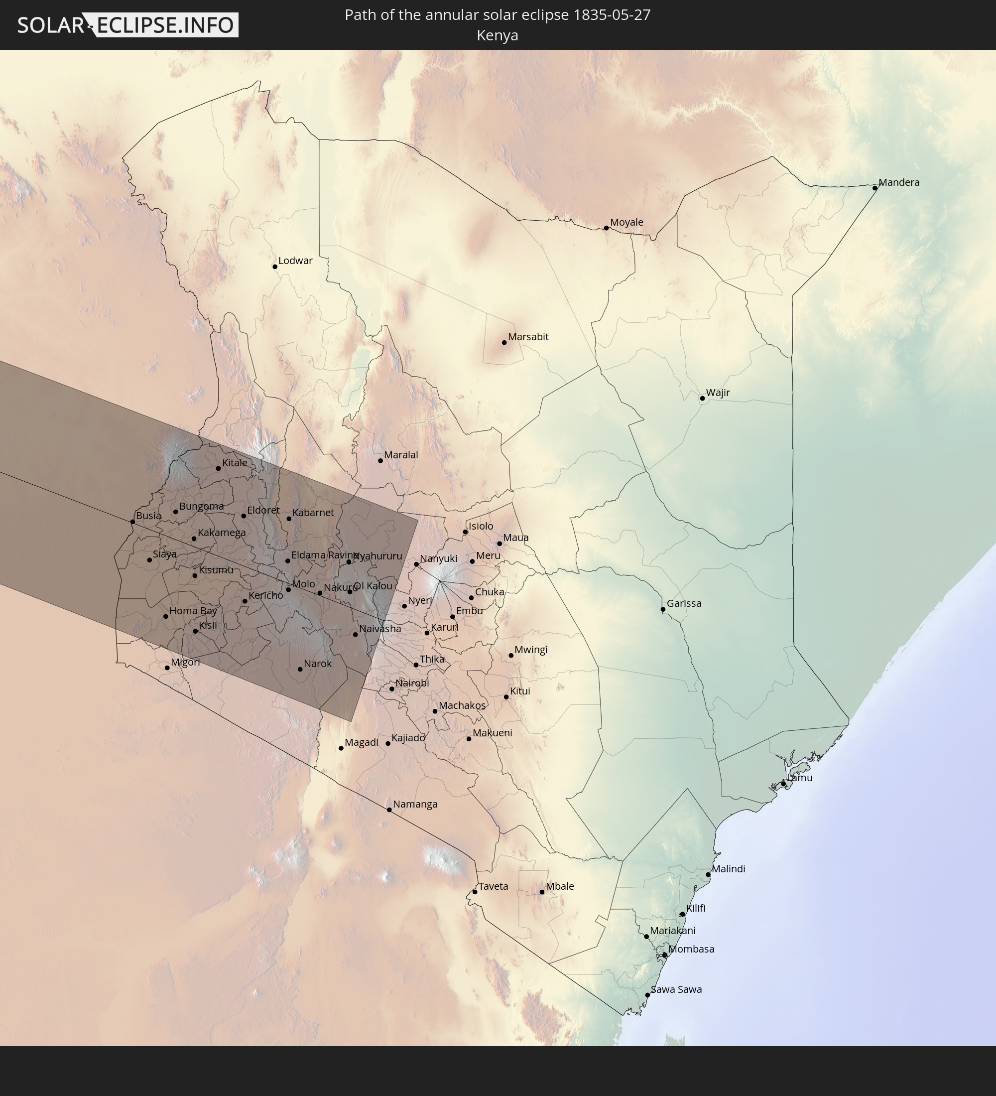
Detailed country maps
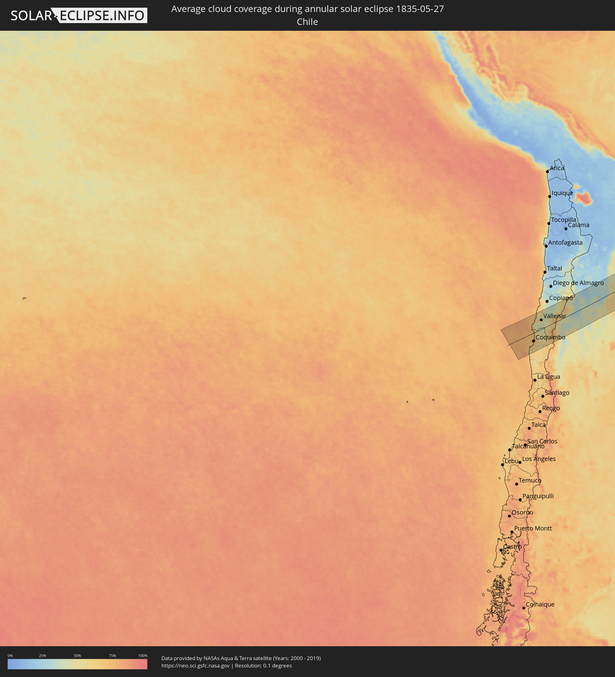 Chile
Chile
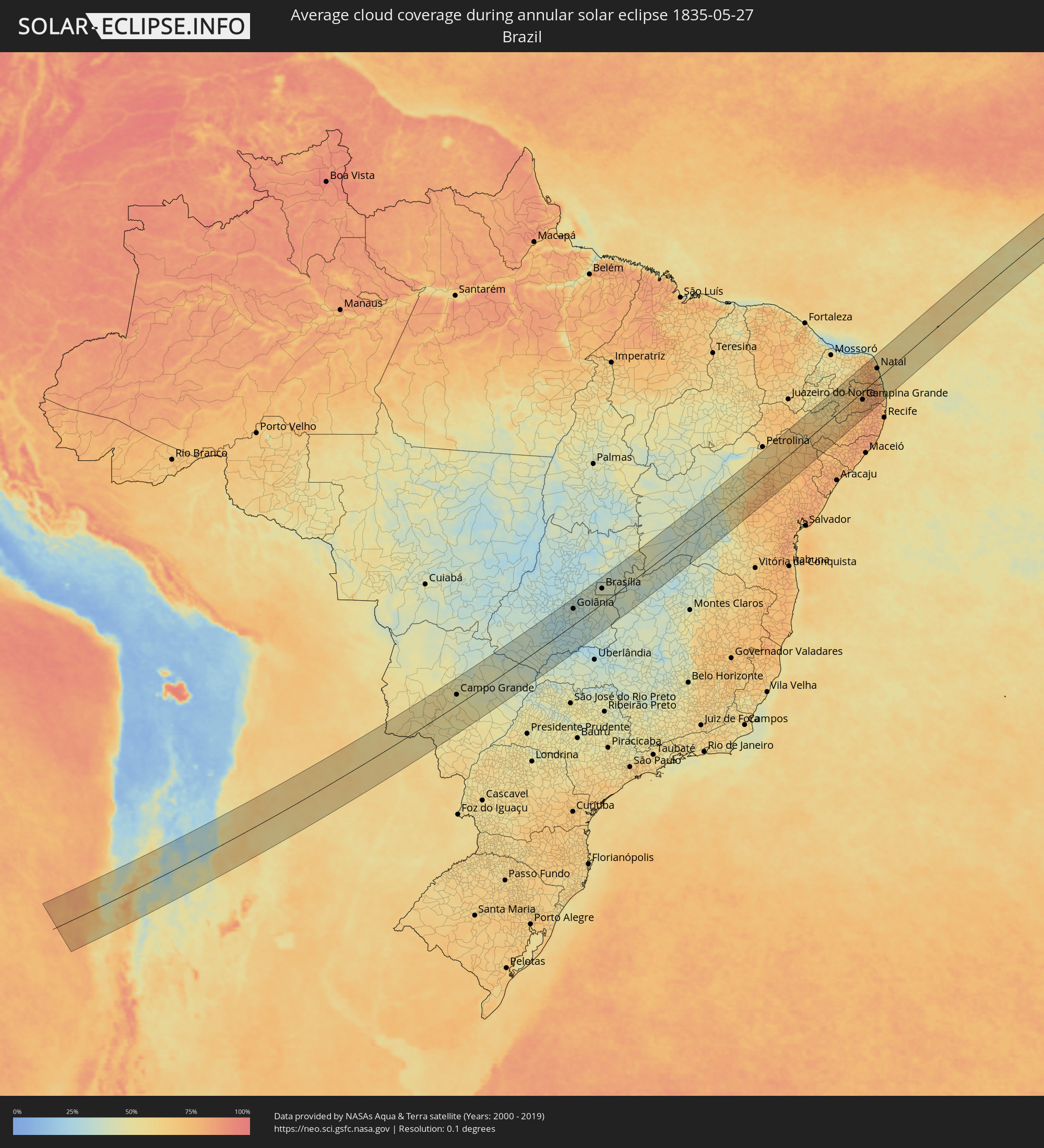 Brazil
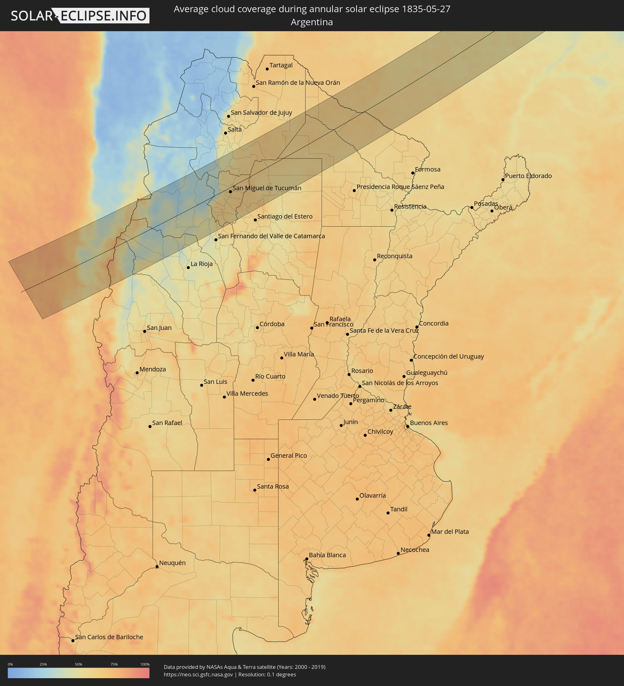 Argentina
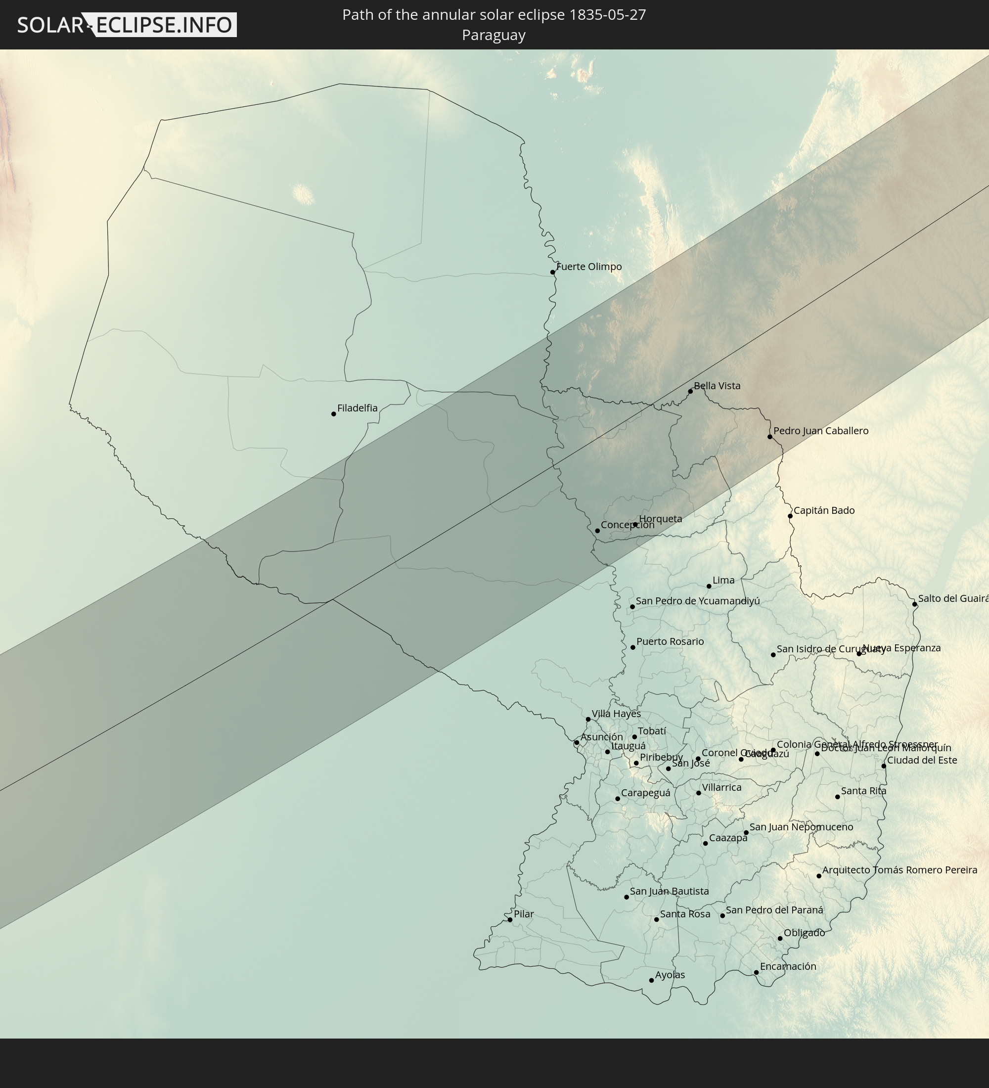
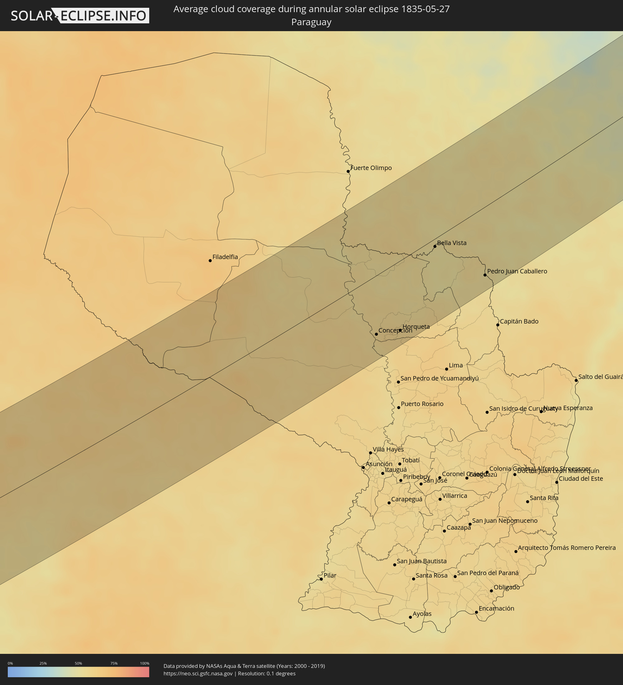 Paraguay
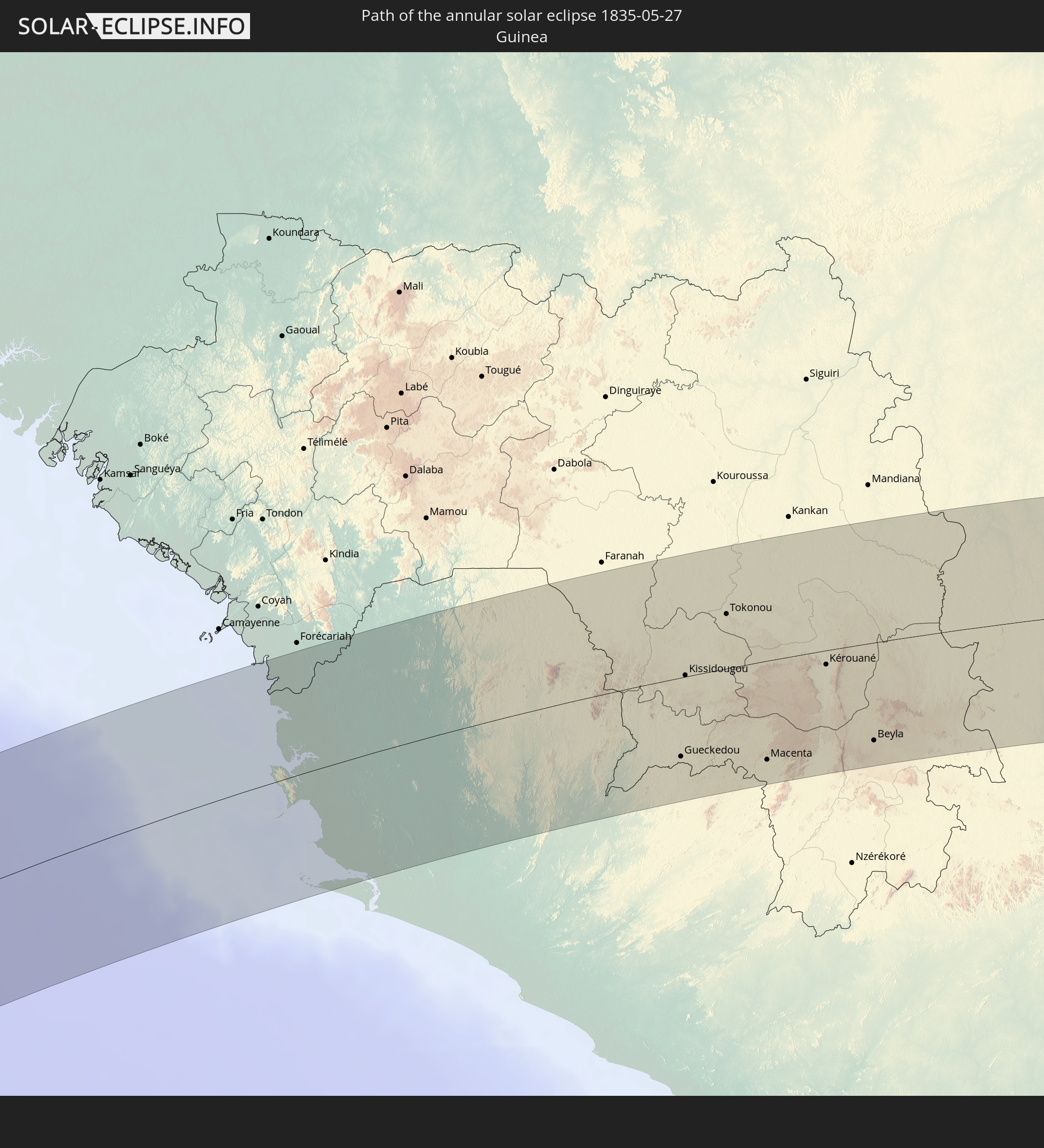
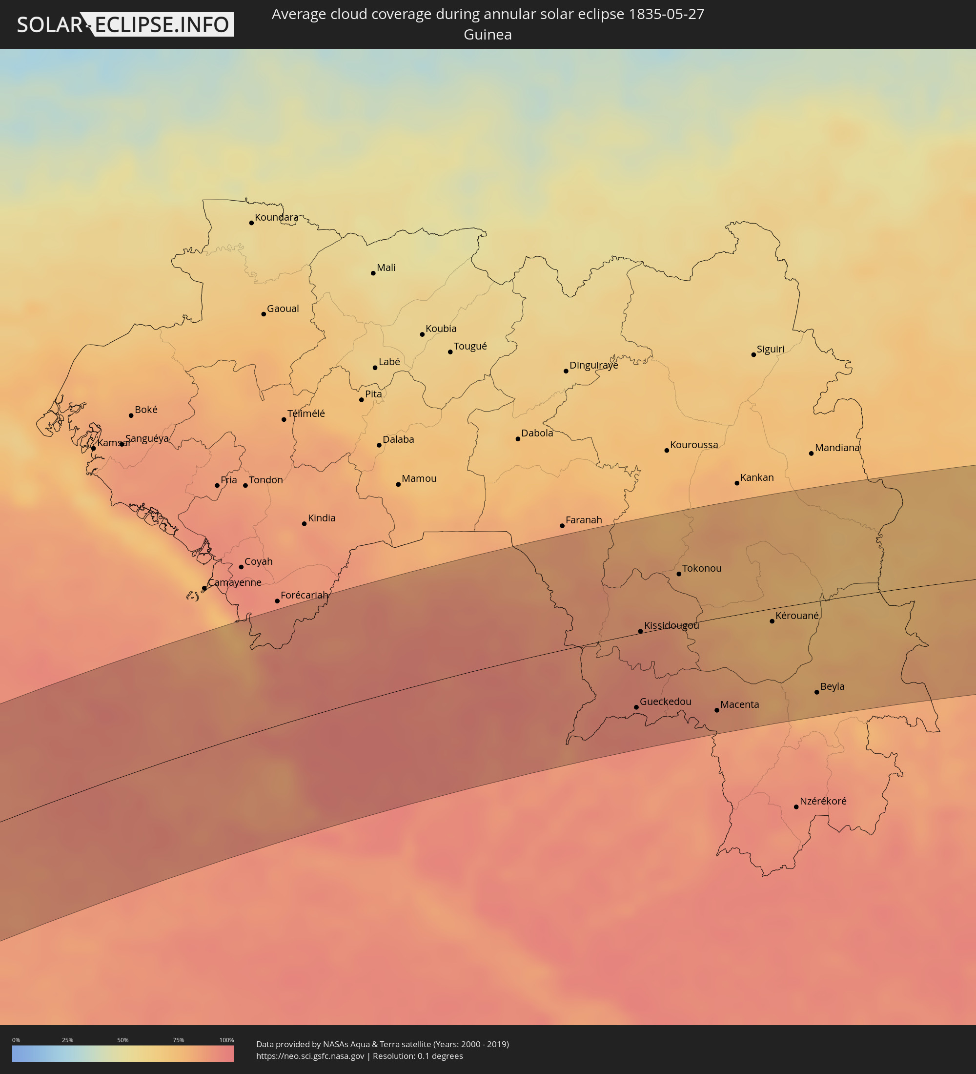 Guinea
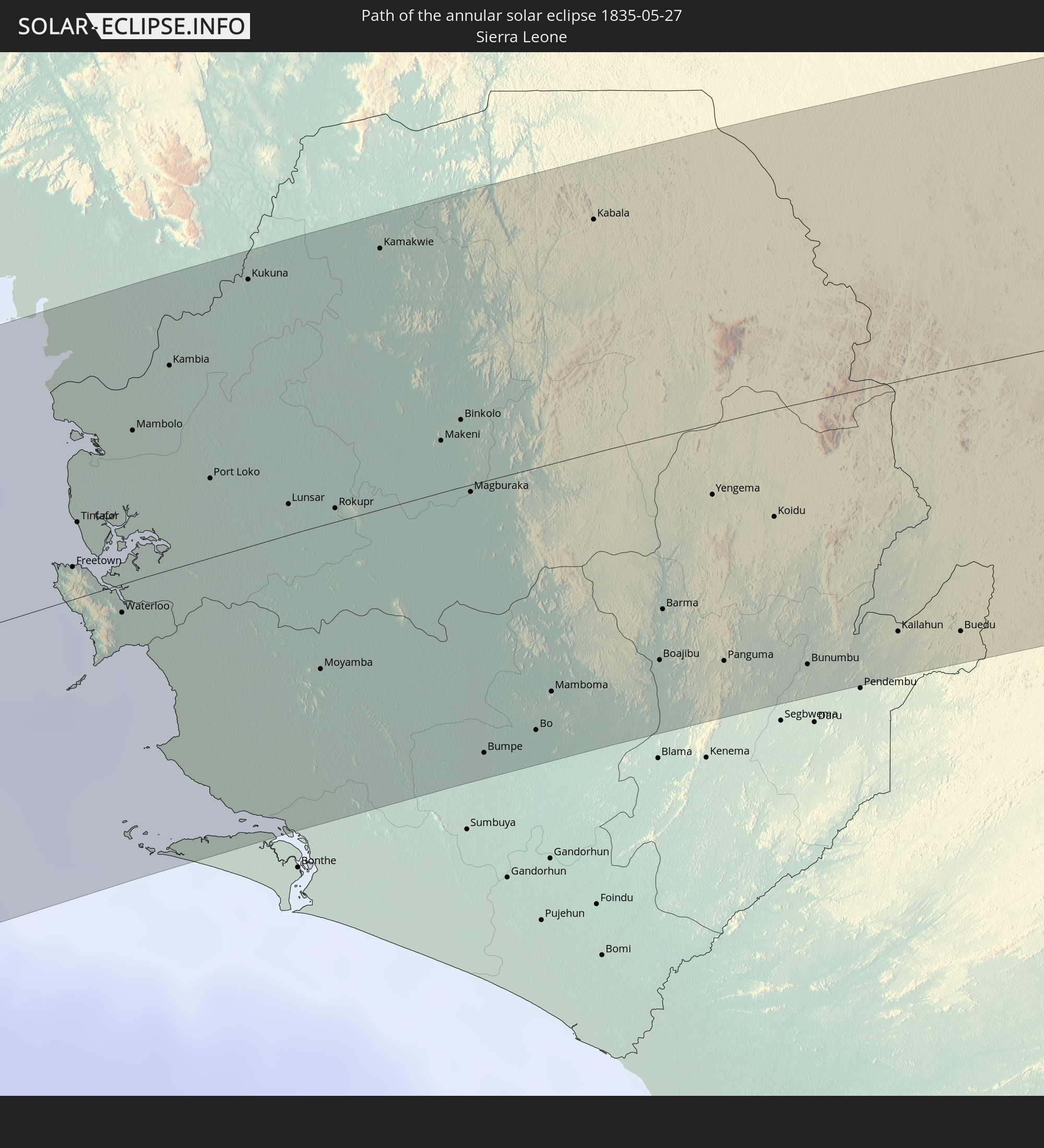
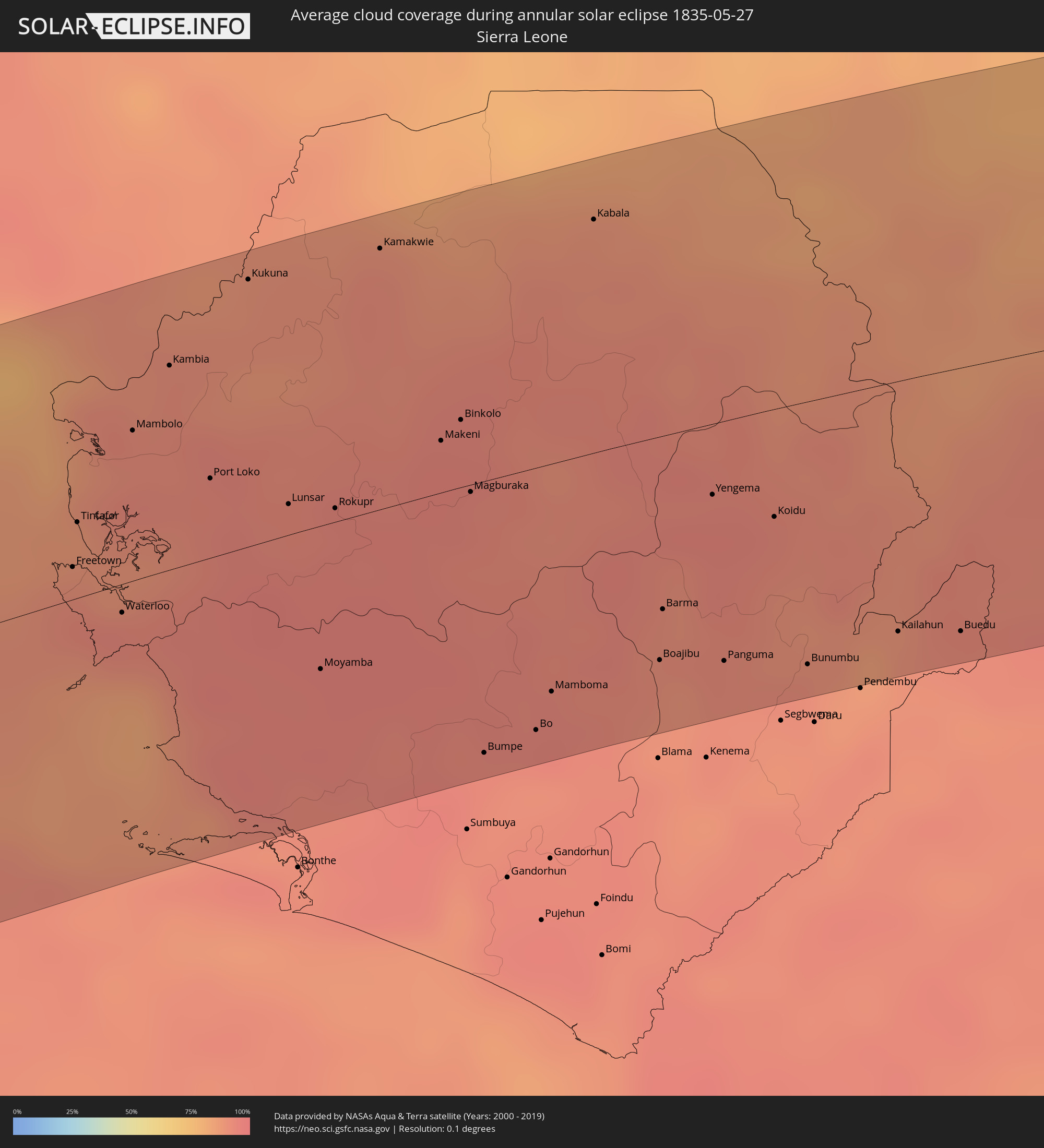 Sierra Leone
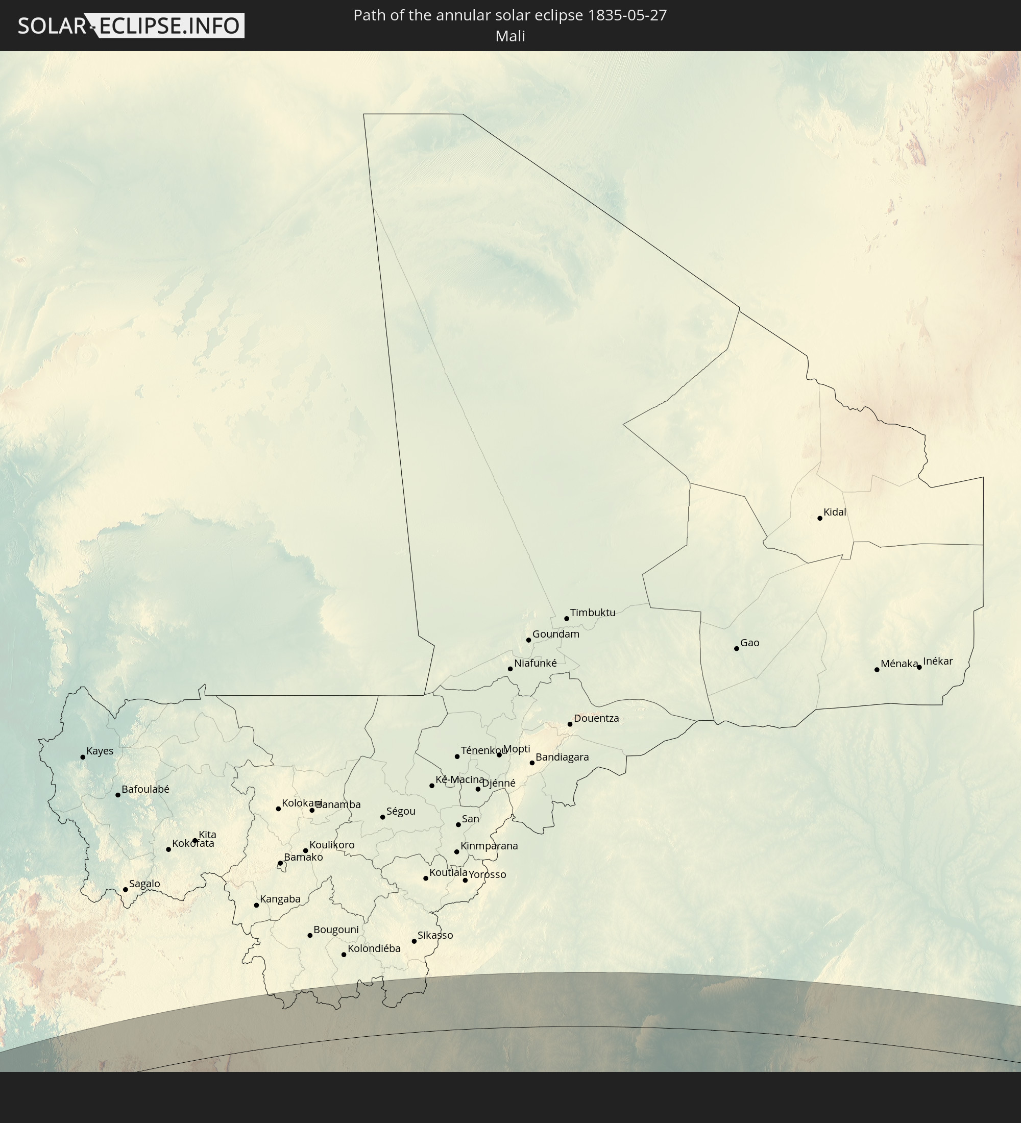
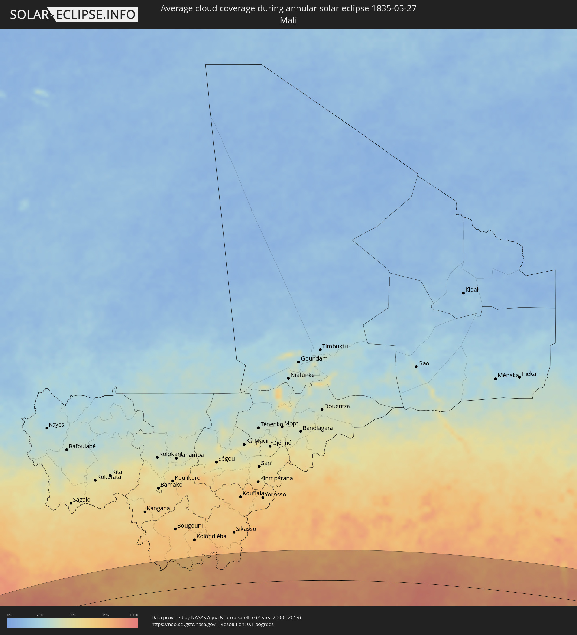 Mali
Mali
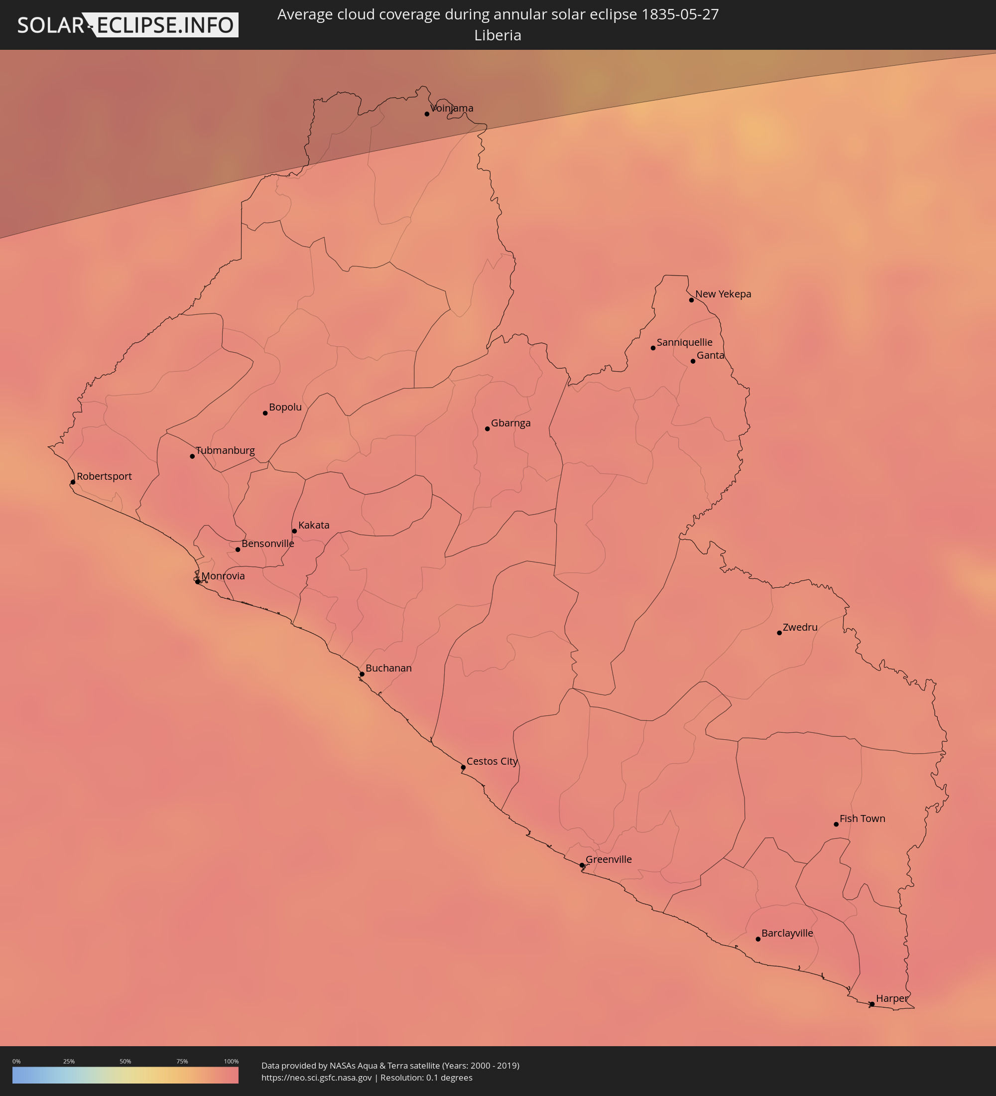 Liberia
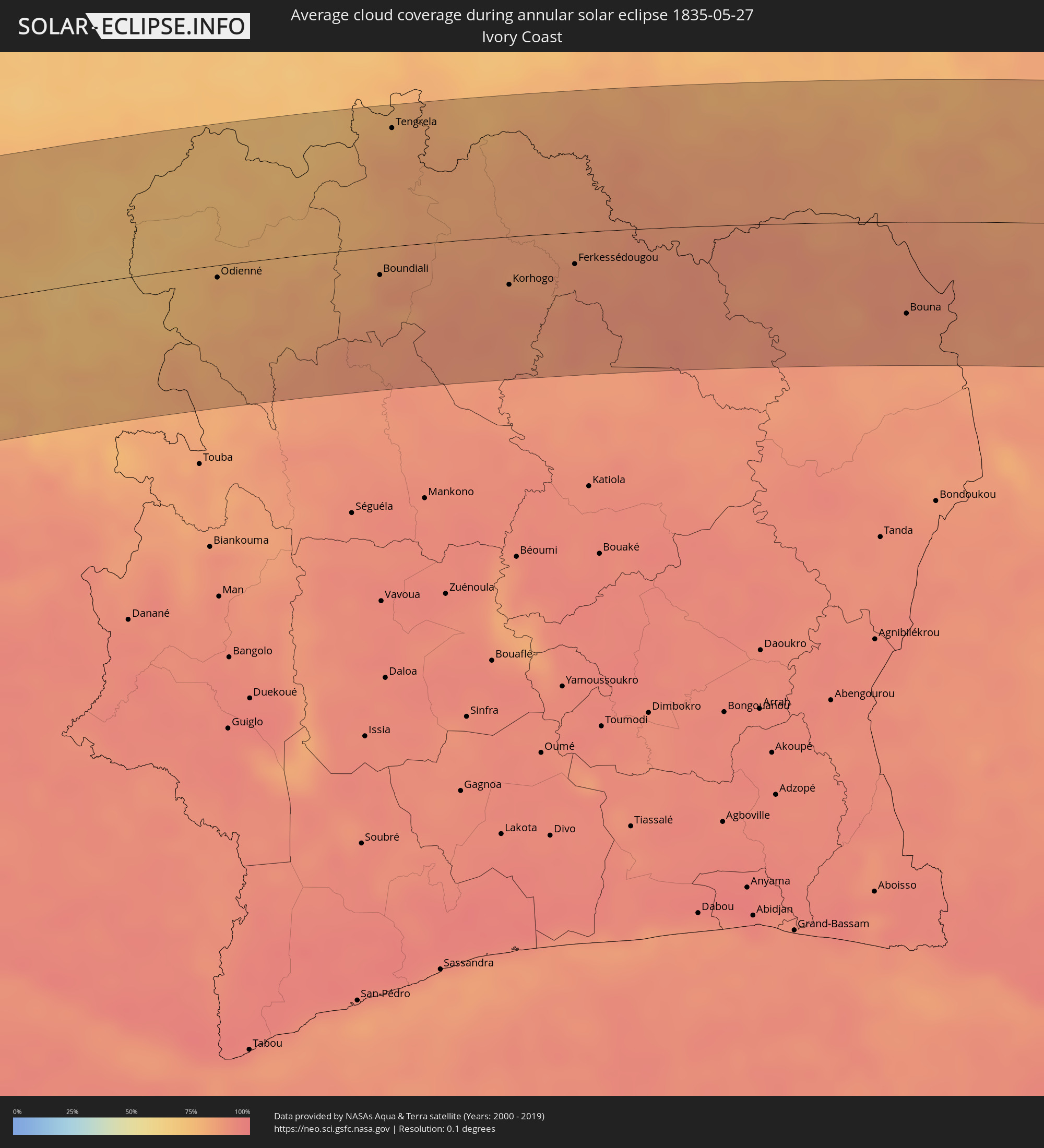 Ivory Coast
 Burkina Faso
 Ghana
Ghana
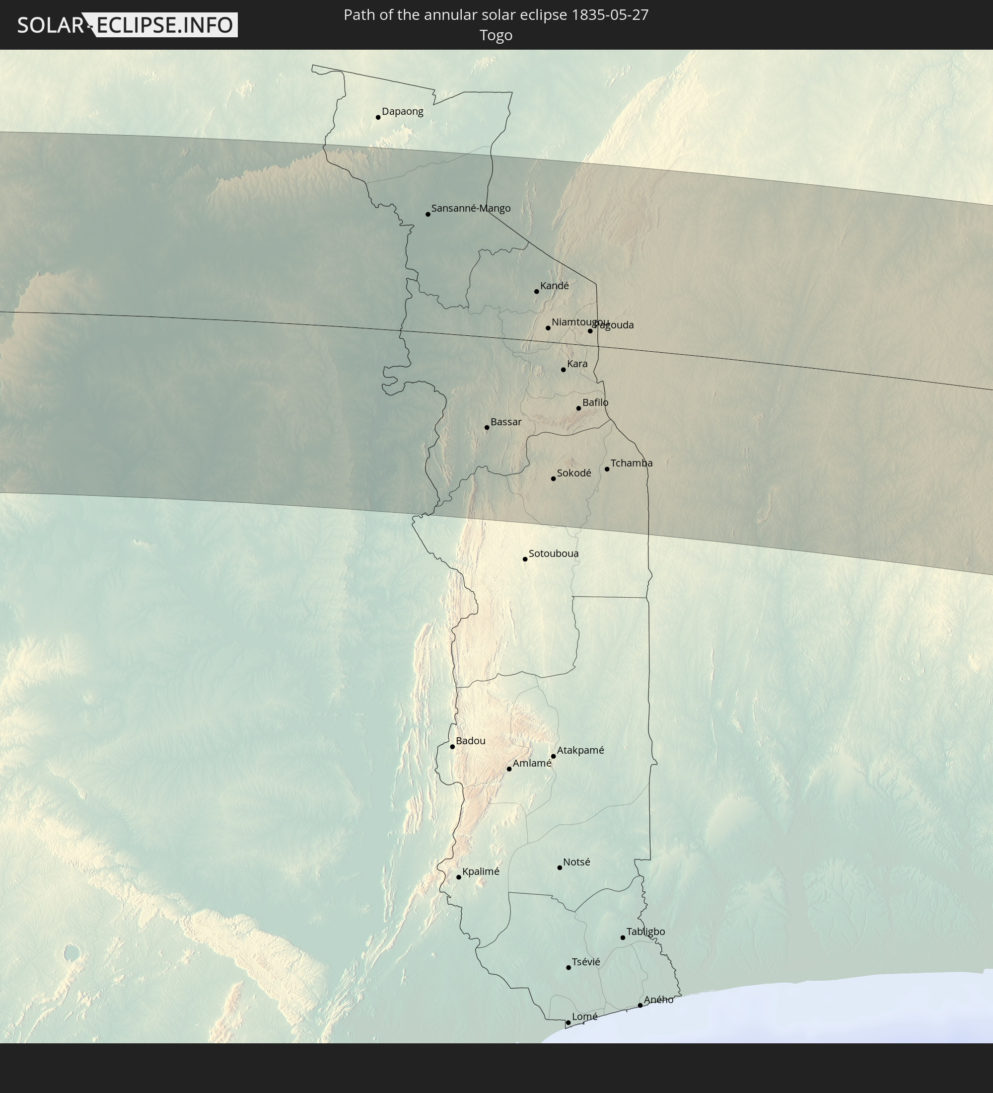
 Togo
Togo
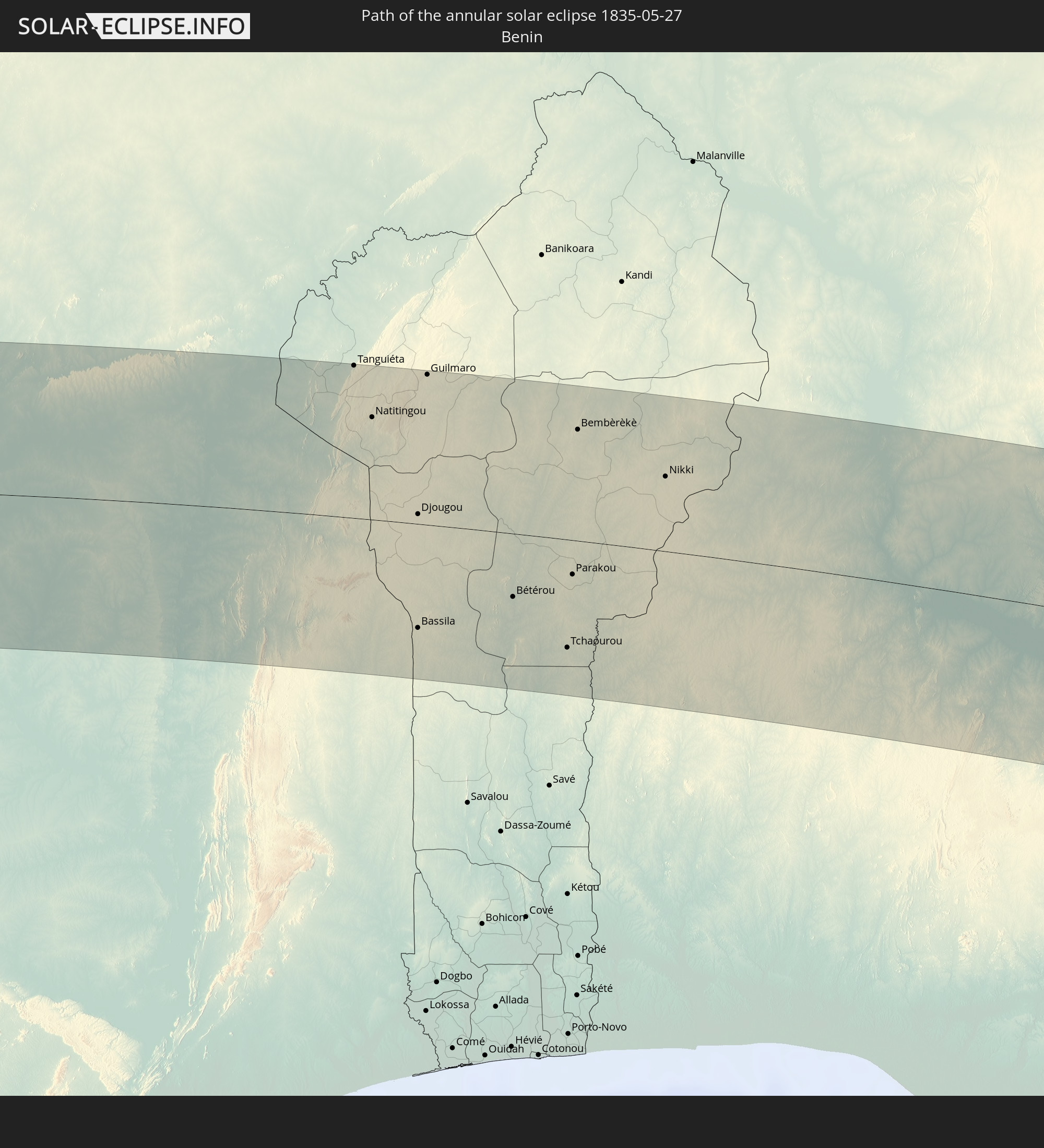
 Benin
Benin
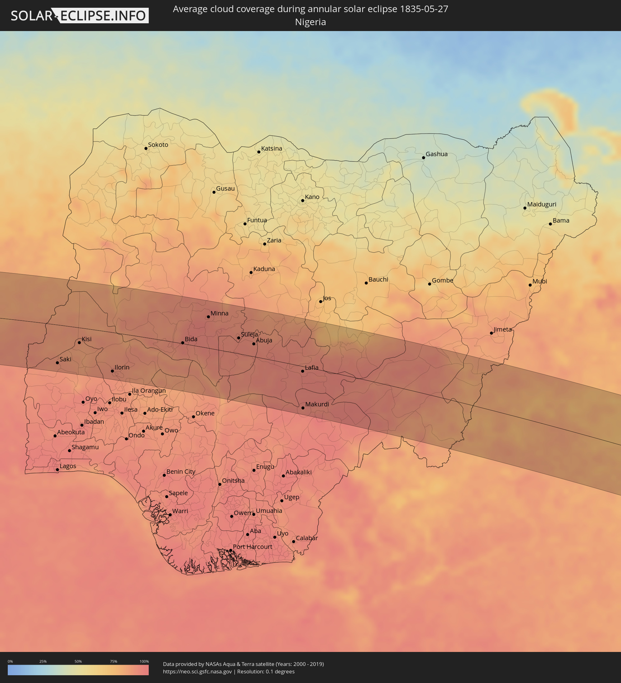 Nigeria
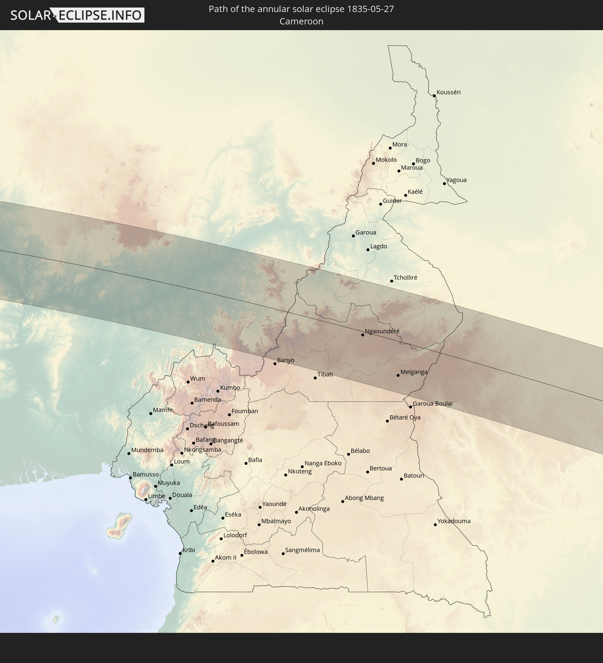
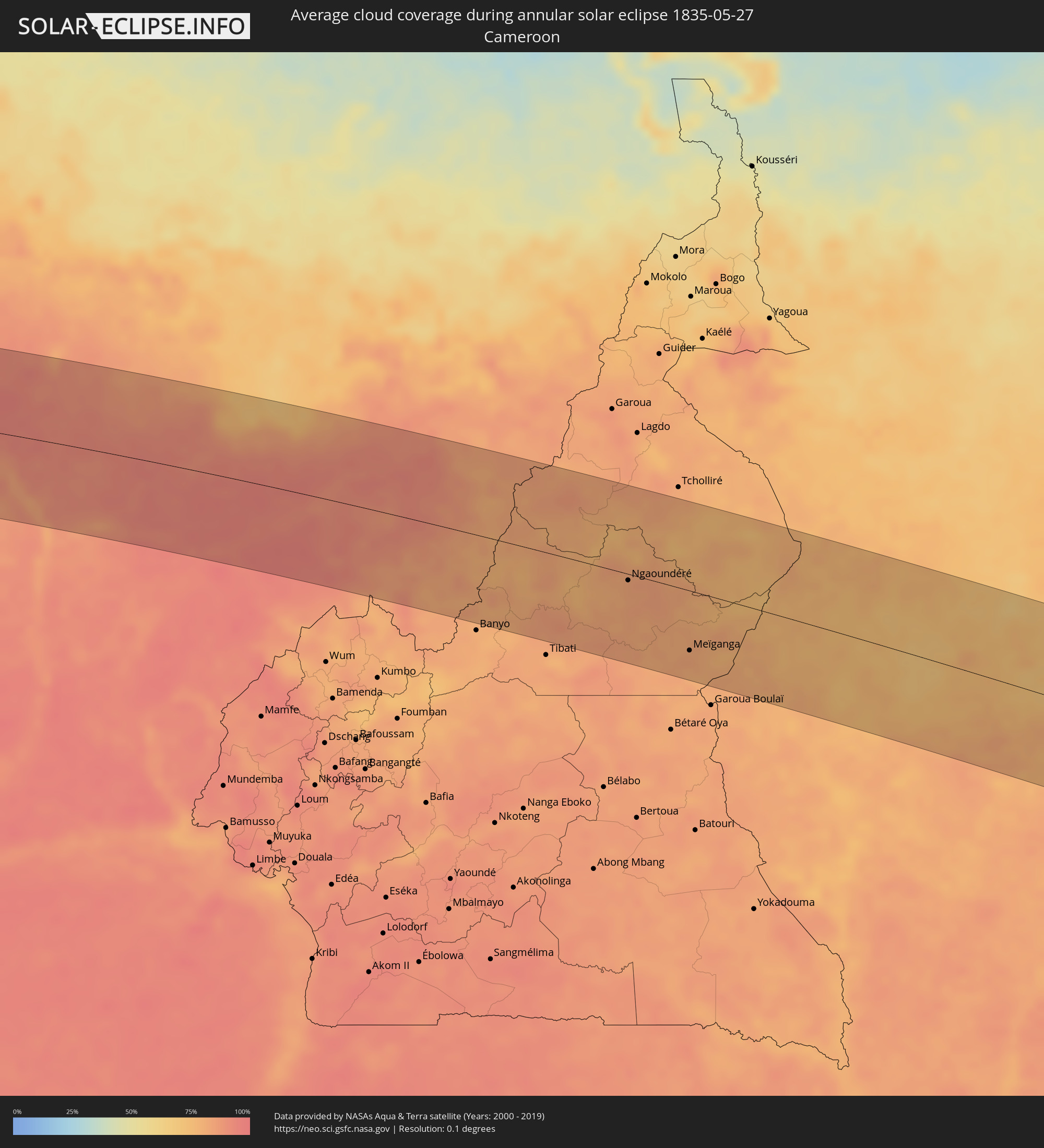 Cameroon
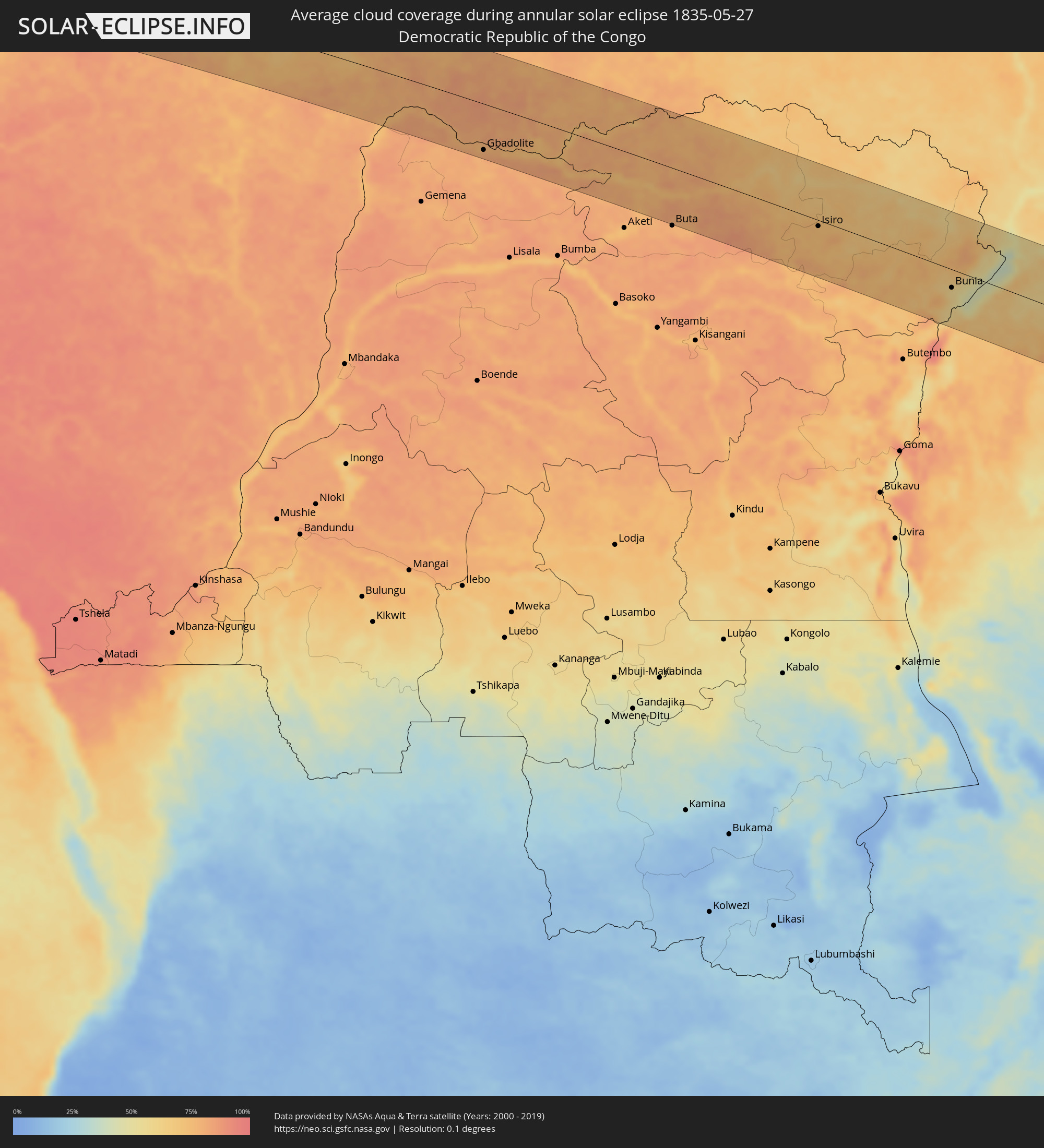 Democratic Republic of the Congo
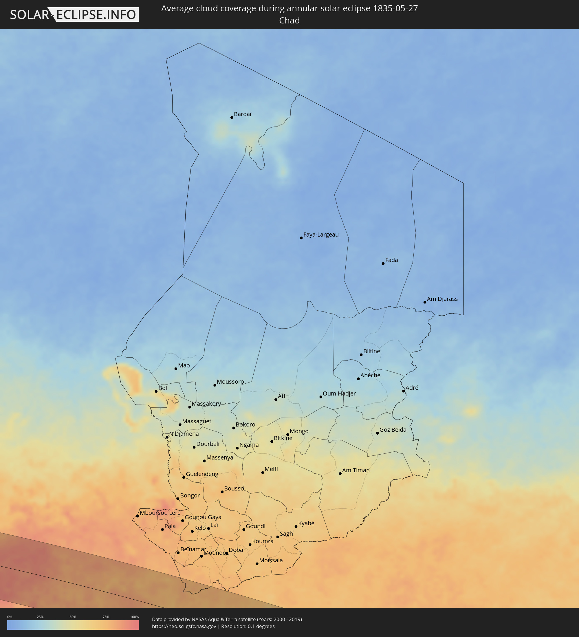 Chad
Chad
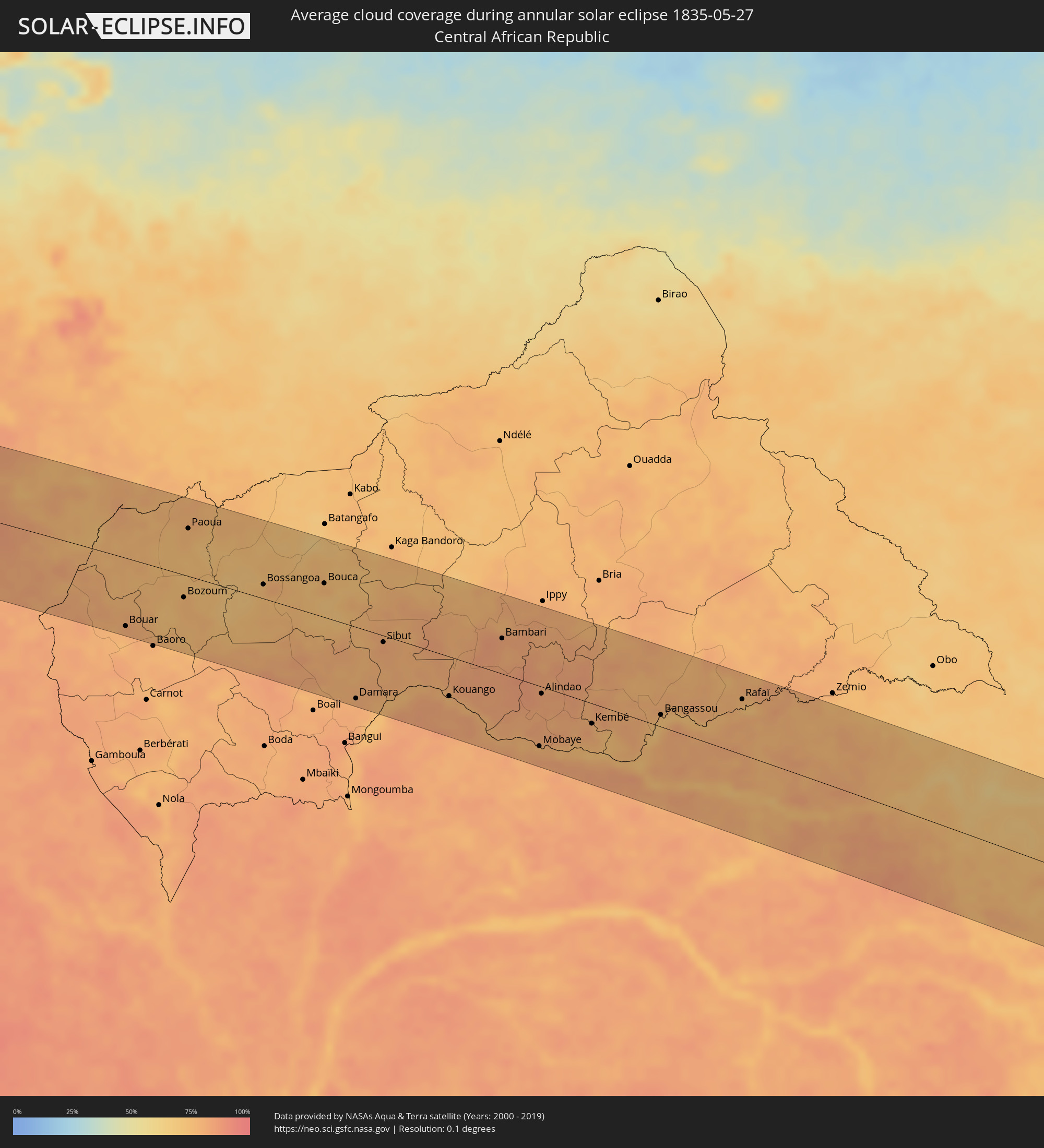 Central African Republic
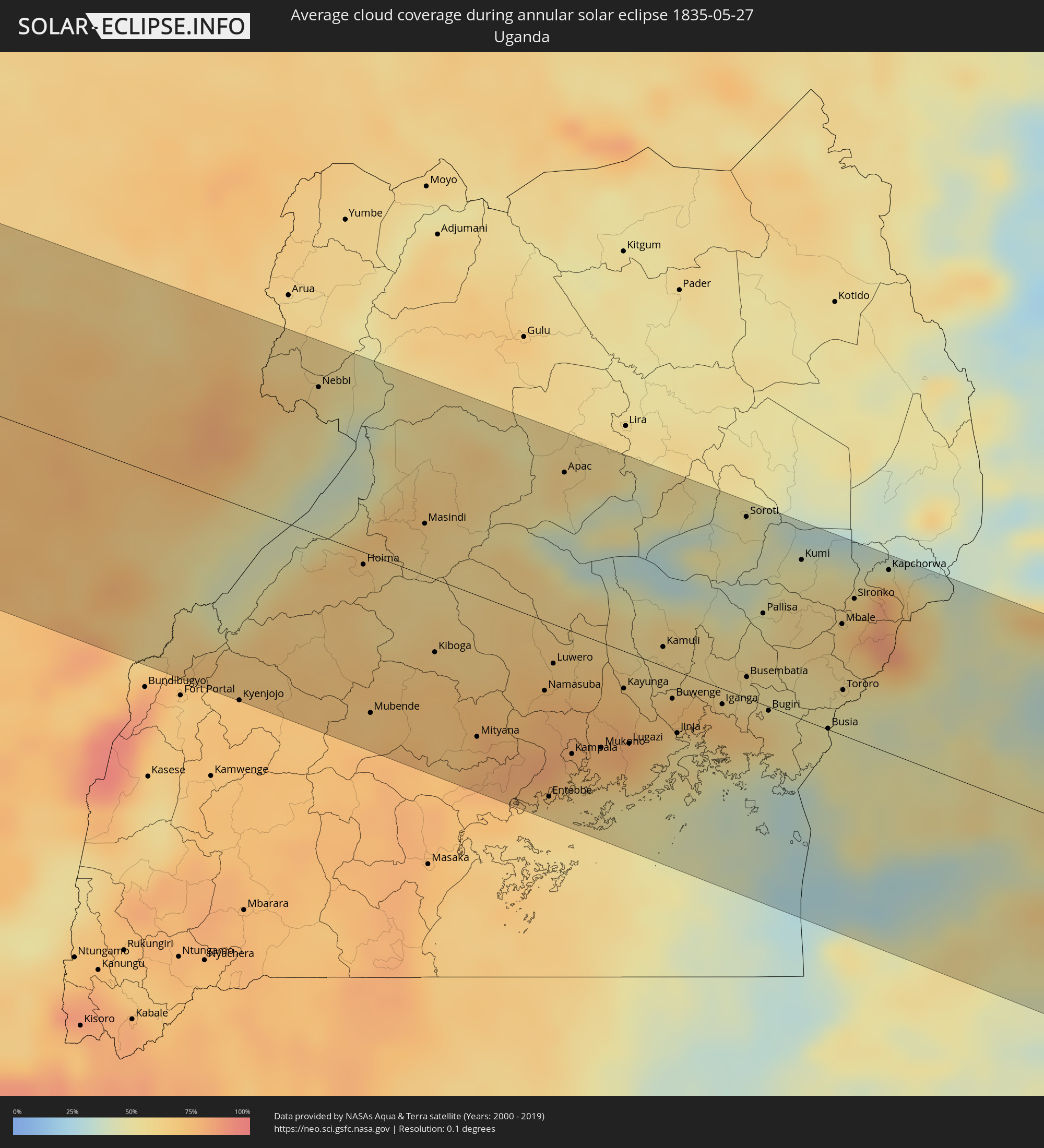 Uganda
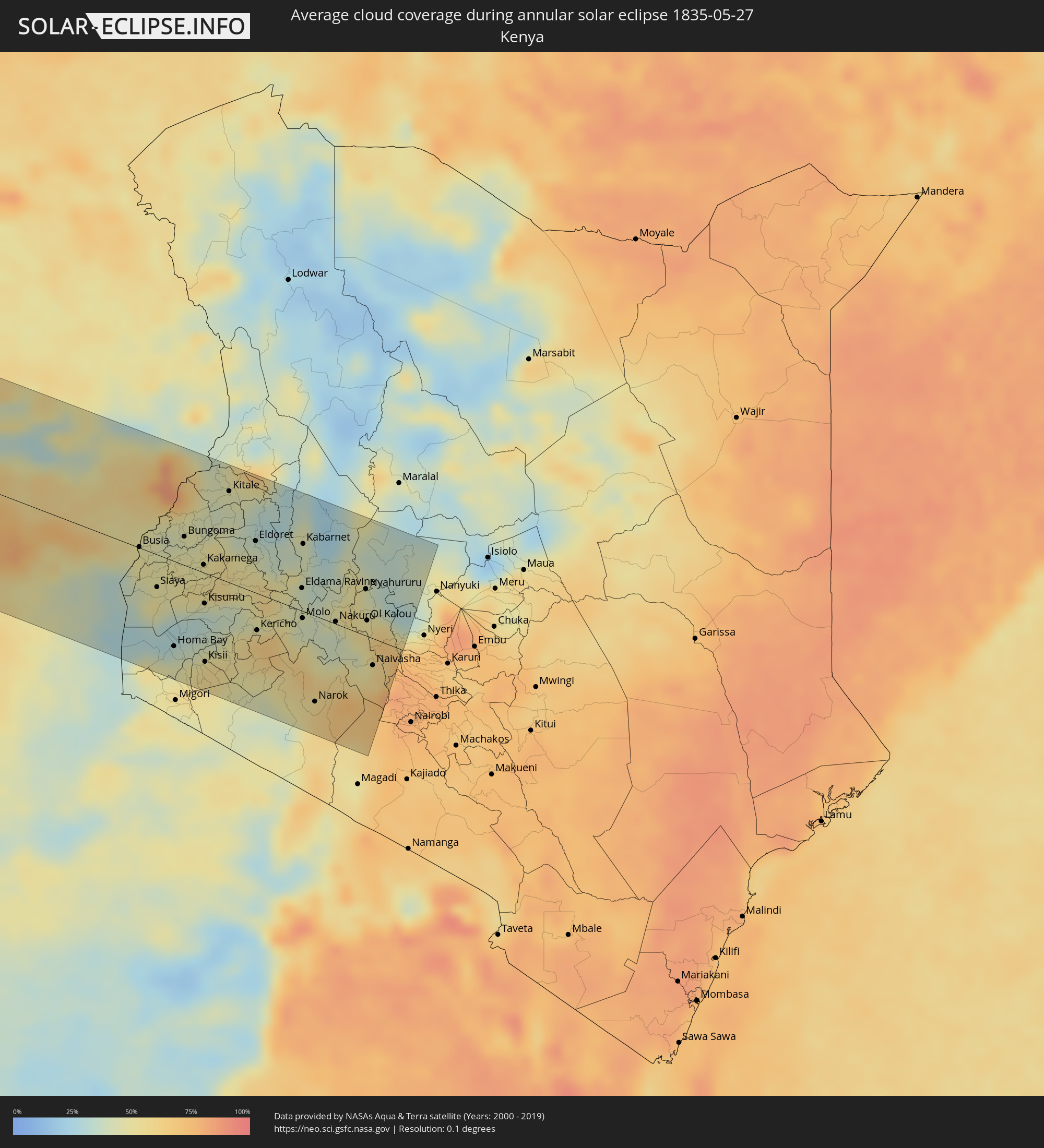 Kenya
Kenya
Cities inside the path of the eclipse
The following table shows all locations with a population of more than 5,000 inside the eclipse path. Cities which have more than 100,000 inhabitants are marked bold. A click at the locations opens a detailed map.
| City | Type | Eclipse duration | Local time of max. eclipse | Distance to central line | Ø Cloud coverage |
|
Coquimbo, Coquimbo
|
annular | - | 06:59:46 UTC-04:42 | 55 km | 69% |
|
La Serena, Coquimbo
|
annular | - | 06:59:46 UTC-04:42 | 54 km | 71% |
|
Vallenar, Atacama
|
annular | - | 06:59:38 UTC-04:42 | 59 km | 51% |
|
Vicuña, Coquimbo
|
annular | - | 06:59:52 UTC-04:42 | 90 km | 54% |
|
Tinogasta, Catamarca Province
|
annular | - | 07:26:12 UTC-04:16 | 31 km | 44% |
|
Arauco, La Rioja Province
|
annular | - | 07:26:27 UTC-04:16 | 117 km | 48% |
|
Andalgalá, Catamarca Province
|
annular | - | 07:26:31 UTC-04:16 | 42 km | 45% |
|
Cafayate, Salta Province
|
annular | - | 07:26:36 UTC-04:16 | 93 km | 34% |
|
Aguilares, Tucumán Province
|
annular | - | 07:26:43 UTC-04:16 | 58 km | 63% |
|
Monteros, Tucumán Province
|
annular | - | 07:26:45 UTC-04:16 | 37 km | 61% |
|
Famaillá, Tucumán Province
|
annular | - | 07:26:46 UTC-04:16 | 31 km | 61% |
|
San Miguel de Tucumán, Tucumán Province
|
annular | - | 07:26:50 UTC-04:16 | 17 km | 62% |
|
Termas de Río Hondo, Santiago del Estero Province
|
annular | - | 07:26:58 UTC-04:16 | 99 km | 58% |
|
Joaquín V. González, Salta Province
|
annular | - | 07:27:16 UTC-04:16 | 104 km | 63% |
|
Ingeniero Guillermo N. Juárez, Formosa Province
|
annular | - | 07:28:24 UTC-04:16 | 103 km | 63% |
|
Las Lomitas, Formosa Province
|
annular | - | 07:28:53 UTC-04:16 | 39 km | 61% |
|
Concepción, Concepción
|
annular | - | 07:57:01 UTC-03:50 | 80 km | 58% |
|
Horqueta, Concepción
|
annular | - | 07:57:16 UTC-03:50 | 95 km | 59% |
|
Bella Vista, Amambay
|
annular | - | 07:57:58 UTC-03:50 | 11 km | 51% |
|
Pedro Juan Caballero, Amambay
|
annular | - | 07:58:23 UTC-03:50 | 93 km | 54% |
|
Campo Grande, Mato Grosso do Sul
|
annular | - | 08:12:09 UTC-03:38 | 42 km | 50% |
|
Trindade, Goiás
|
annular | - | 08:50:58 UTC-03:06 | 81 km | 33% |
|
Goiânia, Goiás
|
annular | - | 08:51:12 UTC-03:06 | 63 km | 36% |
|
Aparecida de Goiânia, Goiás
|
annular | - | 08:51:06 UTC-03:06 | 50 km | 34% |
|
Anápolis, Goiás
|
annular | - | 08:51:46 UTC-03:06 | 76 km | 33% |
|
Luziânia, Goiás
|
annular | - | 08:52:56 UTC-03:06 | 19 km | 40% |
|
Brasília, Federal District
|
annular | - | 08:53:20 UTC-03:06 | 60 km | 42% |
|
Planaltina, Federal District
|
annular | - | 08:53:47 UTC-03:06 | 56 km | 41% |
|
Patos, Paraíba
|
annular | - | 09:51:58 UTC-02:34 | 87 km | 54% |
|
Campina Grande, Paraíba
|
annular | - | 09:54:26 UTC-02:34 | 31 km | 77% |
|
Natal, Rio Grande do Norte
|
annular | - | 09:58:04 UTC-02:34 | 41 km | 61% |
|
João Pessoa, Paraíba
|
annular | - | 09:56:43 UTC-02:34 | 95 km | 73% |
|
Freetown, Western Area
|
annular | - | 13:49:32 UTC-00:16 | 11 km | 91% |
|
Waterloo, Western Area
|
annular | - | 13:49:54 UTC-00:16 | 10 km | 91% |
|
Port Loko, Northern Province
|
annular | - | 13:51:29 UTC-00:16 | 27 km | 93% |
|
Lunsar, Northern Province
|
annular | - | 13:52:16 UTC-00:16 | 10 km | 93% |
|
Rokupr, Northern Province
|
annular | - | 13:52:46 UTC-00:16 | 5 km | 94% |
|
Makeni, Northern Province
|
annular | - | 13:54:15 UTC-00:16 | 18 km | 94% |
|
Magburaka, Northern Province
|
annular | - | 13:54:22 UTC-00:16 | 3 km | 93% |
|
Bumpe, Southern Province
|
annular | - | 13:53:27 UTC-00:16 | 93 km | 92% |
|
Bo, Southern Province
|
annular | - | 13:54:08 UTC-00:16 | 90 km | 94% |
|
Kabala, Northern Province
|
annular | - | 13:56:49 UTC-00:16 | 80 km | 89% |
|
Koidu, Eastern Province
|
annular | - | 13:57:41 UTC-00:16 | 37 km | 92% |
|
Kailahun, Eastern Province
|
annular | - | 13:58:38 UTC-00:16 | 87 km | 90% |
|
Gueckedou, Nzerekore
|
annular | - | 14:00:30 UTC-00:16 | 65 km | 91% |
|
Kissidougou, Faranah
|
annular | - | 14:01:19 UTC-00:16 | 1 km | 88% |
|
Tokonou, Kankan
|
annular | - | 14:02:54 UTC-00:16 | 45 km | 80% |
|
Voinjama, Lofa
|
annular | - | 13:34:40 UTC-00:43 | 90 km | 90% |
|
Macenta, Nzerekore
|
annular | - | 14:02:45 UTC-00:16 | 82 km | 86% |
|
Kérouané, Kankan
|
annular | - | 14:05:04 UTC-00:16 | 12 km | 76% |
|
Beyla, Nzerekore
|
annular | - | 14:05:42 UTC-00:16 | 82 km | 78% |
|
Odienné, Denguélé
|
annular | - | 14:10:05 UTC-00:16 | 9 km | 77% |
|
Boundiali, Savanes
|
annular | - | 14:13:34 UTC-00:16 | 20 km | 85% |
|
Tengrela, Savanes
|
annular | - | 14:14:35 UTC-00:16 | 86 km | 79% |
|
Korhogo, Savanes
|
annular | - | 14:16:12 UTC-00:16 | 35 km | 86% |
|
Ferkessédougou, Savanes
|
annular | - | 14:17:39 UTC-00:16 | 23 km | 87% |
|
Banfora, Cascades
|
annular | - | 14:19:40 UTC-00:16 | 90 km | 82% |
|
Gaoua, Sud-Ouest
|
annular | - | 14:23:52 UTC-00:16 | 48 km | 81% |
|
Bouna, Zanzan
|
annular | - | 14:23:59 UTC-00:16 | 67 km | 88% |
|
Batié, Sud-Ouest
|
annular | - | 14:24:34 UTC-00:16 | 2 km | 86% |
|
Wa, Upper West
|
annular | - | 14:41:07 UTC-00:00 | 21 km | 84% |
|
Tamale, Northern
|
annular | - | 14:45:20 UTC-00:00 | 47 km | 89% |
|
Savelugu, Northern
|
annular | - | 14:45:28 UTC-00:00 | 22 km | 88% |
|
Yendi, Northern
|
annular | - | 14:47:32 UTC-00:00 | 38 km | 93% |
|
Sansanné-Mango, Savanes
|
annular | - | 14:33:52 UTC-00:16 | 68 km | 88% |
|
Bassar, Kara
|
annular | - | 14:34:13 UTC-00:16 | 53 km | 90% |
|
Kandé, Kara
|
annular | - | 14:35:08 UTC-00:16 | 28 km | 89% |
|
Niamtougou, Kara
|
annular | - | 14:35:13 UTC-00:16 | 8 km | 86% |
|
Sokodé, Centrale
|
annular | - | 14:35:00 UTC-00:16 | 79 km | 88% |
|
Kara, Kara
|
annular | - | 14:35:20 UTC-00:16 | 16 km | 88% |
|
Tanguiéta, Atakora
|
annular | - | 15:05:37 UTC+00:13 | 104 km | 82% |
|
Bafilo, Kara
|
annular | - | 14:35:28 UTC-00:16 | 37 km | 87% |
|
Pagouda, Kara
|
annular | - | 14:35:46 UTC-00:16 | 8 km | 87% |
|
Natitingou, Atakora
|
annular | - | 15:05:47 UTC+00:13 | 70 km | 84% |
|
Tchamba, Centrale
|
annular | - | 14:35:43 UTC-00:16 | 71 km | 89% |
|
Bassila, Donga
|
annular | - | 15:06:02 UTC+00:13 | 71 km | 89% |
|
Djougou, Donga
|
annular | - | 15:06:17 UTC+00:13 | 7 km | 84% |
|
Guilmaro, Atakora
|
annular | - | 15:06:42 UTC+00:13 | 102 km | 79% |
|
Bétérou, Borgou
|
annular | - | 15:07:32 UTC+00:13 | 43 km | 89% |
|
Tchaourou, Borgou
|
annular | - | 15:08:14 UTC+00:13 | 74 km | 88% |
|
Parakou, Borgou
|
annular | - | 15:08:27 UTC+00:13 | 23 km | 88% |
|
Bembèrèkè, Borgou
|
annular | - | 15:08:47 UTC+00:13 | 76 km | 82% |
|
Nikki, Borgou
|
annular | - | 15:09:57 UTC+00:13 | 51 km | 84% |
|
Saki, Oyo
|
annular | - | 15:10:01 UTC+00:13 | 87 km | 88% |
|
Igboho, Oyo
|
annular | - | 15:10:53 UTC+00:13 | 63 km | 86% |
|
Kisi, Oyo
|
annular | - | 15:11:10 UTC+00:13 | 35 km | 84% |
|
Ilorin, Kwara
|
annular | - | 15:12:32 UTC+00:13 | 89 km | 90% |
|
Lafiagi, Kwara
|
annular | - | 15:14:28 UTC+00:13 | 35 km | 90% |
|
Bida, Niger
|
annular | - | 15:15:44 UTC+00:13 | 1 km | 93% |
|
Minna, Niger
|
annular | - | 15:16:53 UTC+00:13 | 70 km | 94% |
|
Suleja, Niger
|
annular | - | 15:18:02 UTC+00:13 | 35 km | 92% |
|
Abuja, Abuja Federal Capital Territory
|
annular | - | 15:18:37 UTC+00:13 | 28 km | 92% |
|
Lafia, Nassarawa
|
annular | - | 15:20:24 UTC+00:13 | 12 km | 94% |
|
Makurdi, Benue
|
annular | - | 15:20:18 UTC+00:13 | 94 km | 94% |
|
Jalingo, Taraba
|
annular | - | 15:25:09 UTC+00:13 | 101 km | 89% |
|
Kontcha, Adamaoua
|
annular | - | 15:26:25 UTC+00:13 | 23 km | 83% |
|
Poli, North
|
annular | - | 15:27:53 UTC+00:13 | 106 km | 82% |
|
Ngaoundéré, Adamaoua
|
annular | - | 15:28:17 UTC+00:13 | 8 km | 82% |
|
Meïganga, Adamaoua
|
annular | - | 15:29:11 UTC+00:13 | 74 km | 83% |
|
Bélel, Adamaoua
|
annular | - | 15:29:25 UTC+00:13 | 13 km | 79% |
|
Bouar, Nana-Mambéré
|
annular | - | 15:30:48 UTC+00:13 | 98 km | 79% |
|
Bozoum, Ouham-Pendé
|
annular | - | 15:31:46 UTC+00:13 | 32 km | 76% |
|
Paoua, Ouham-Pendé
|
annular | - | 15:31:53 UTC+00:13 | 68 km | 76% |
|
Bossangoa, Ouham
|
annular | - | 15:33:00 UTC+00:13 | 20 km | 79% |
|
Bouca, Ouham
|
annular | - | 15:33:52 UTC+00:13 | 48 km | 76% |
|
Damara, Ombella-M'Poko
|
annular | - | 15:34:12 UTC+00:13 | 102 km | 80% |
|
Sibut, Kémo
|
annular | - | 15:34:38 UTC+00:13 | 9 km | 81% |
|
Bambari, Ouaka
|
annular | - | 15:36:07 UTC+00:13 | 50 km | 82% |
|
Gbadolite, Équateur
|
annular | - | 15:36:18 UTC+00:13 | 96 km | 80% |
|
Mobaye, Basse-Kotto
|
annular | - | 15:36:27 UTC+00:13 | 86 km | 79% |
|
Alindao, Basse-Kotto
|
annular | - | 15:36:32 UTC+00:13 | 10 km | 82% |
|
Bangassou, Mbomou
|
annular | - | 15:37:48 UTC+00:13 | 17 km | 72% |
|
Bondo, Orientale
|
annular | - | 17:35:06 UTC+02:10 | 49 km | 70% |
|
Rafaï, Mbomou
|
annular | - | 15:38:35 UTC+00:13 | 78 km | 75% |
|
Isiro, Orientale
|
annular | - | 17:37:18 UTC+02:10 | 12 km | 73% |
|
Wamba, Orientale
|
annular | - | 17:37:25 UTC+02:10 | 63 km | 74% |
|
Watsa, Orientale
|
annular | - | 17:38:10 UTC+02:10 | 89 km | 66% |
|
Bunia, Orientale
|
annular | - | 17:38:15 UTC+02:10 | 38 km | 57% |
|
Hoima, Western Region
|
annular | - | 17:55:32 UTC+02:27 | 8 km | 65% |
|
Mityana, Central Region
|
annular | - | 17:55:34 UTC+02:27 | 87 km | 74% |
|
Entebbe, Central Region
|
annular | - | 17:55:37 UTC+02:27 | 107 km | 63% |
|
Kampala, Central Region
|
annular | - | 17:55:42 UTC+02:27 | 75 km | 70% |
|
Mukono, Central Region
|
annular | - | 17:55:44 UTC+02:27 | 64 km | 77% |
|
Lugazi, Central Region
|
annular | - | 17:55:47 UTC+02:27 | 55 km | 79% |
|
Jinja, Eastern Region
|
annular | - | 17:55:52 UTC+02:27 | 38 km | 55% |
|
Iganga, Eastern Region
|
annular | - | 17:55:57 UTC+02:27 | 9 km | 71% |
|
Soroti, Eastern Region
|
annular | - | 17:56:08 UTC+02:27 | 111 km | 52% |
|
Busia, Eastern Region
|
annular | - | 17:56:03 UTC+02:27 | 1 km | 49% |
|
Busia, Busia
|
annular | - | 17:56:03 UTC+02:27 | 1 km | 49% |
|
Mbale, Eastern Region
|
annular | - | 17:56:10 UTC+02:27 | 68 km | 70% |
|
Tororo, Eastern Region
|
annular | - | 17:56:06 UTC+02:27 | 28 km | 50% |
|
Lugulu, Busia
|
annular | - | 17:56:04 UTC+02:27 | 2 km | 46% |
|
Homa Bay, Homa Bay
|
annular | - | 17:55:55 UTC+02:27 | 88 km | 37% |
|
Mumias, Kakamega
|
annular | - | 17:56:06 UTC+02:27 | 3 km | 50% |
|
Bungoma, Bungoma
|
annular | - | 17:56:09 UTC+02:27 | 29 km | 46% |
|
Kakamega, Kakamega
|
annular | - | 17:56:08 UTC+02:27 | 8 km | 50% |
|
Kisumu, Kisumu
|
annular | - | 17:56:04 UTC+02:27 | 32 km | 34% |
|
Kitale, Trans Nzoia
|
annular | - | 17:56:17 UTC+02:27 | 94 km | 45% |
|
Kapenguria, West Pokot
|
annular | - | 17:56:20 UTC+02:27 | 121 km | 53% |
|
Eldoret, Uasin Gishu
|
annular | - | 17:56:15 UTC+02:27 | 54 km | 38% |
|
Nakuru, Nakuru
|
annular | - | 17:56:12 UTC+02:27 | 2 km | 39% |
|
Ol Kalou, Nyandarua
|
annular | - | 17:56:14 UTC+02:27 | 16 km | 54% |