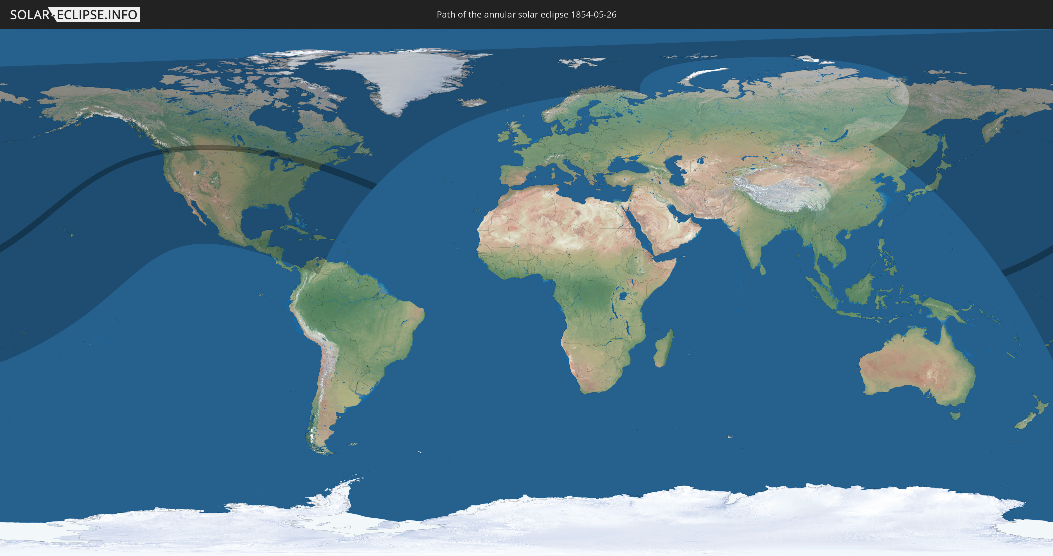
Annular solar eclipse of 05/26/1854
| Day of week: | Friday |
| Maximum duration of eclipse: | 04m32s |
| Maximum width of eclipse path: | 178 km |
| Saros cycle: | 135 |
| Coverage: | 95.5% |
| Magnitude: | 0.9551 |
| Gamma: | 0.3918 |
Wo kann man die Sonnenfinsternis vom 05/26/1854 sehen?
Die Sonnenfinsternis am 05/26/1854 kann man in 44 Ländern als partielle Sonnenfinsternis beobachten.
Der Finsternispfad verläuft durch 4 Länder. Nur in diesen Ländern ist sie als annular Sonnenfinsternis zu sehen.
In den folgenden Ländern ist die Sonnenfinsternis annular zu sehen
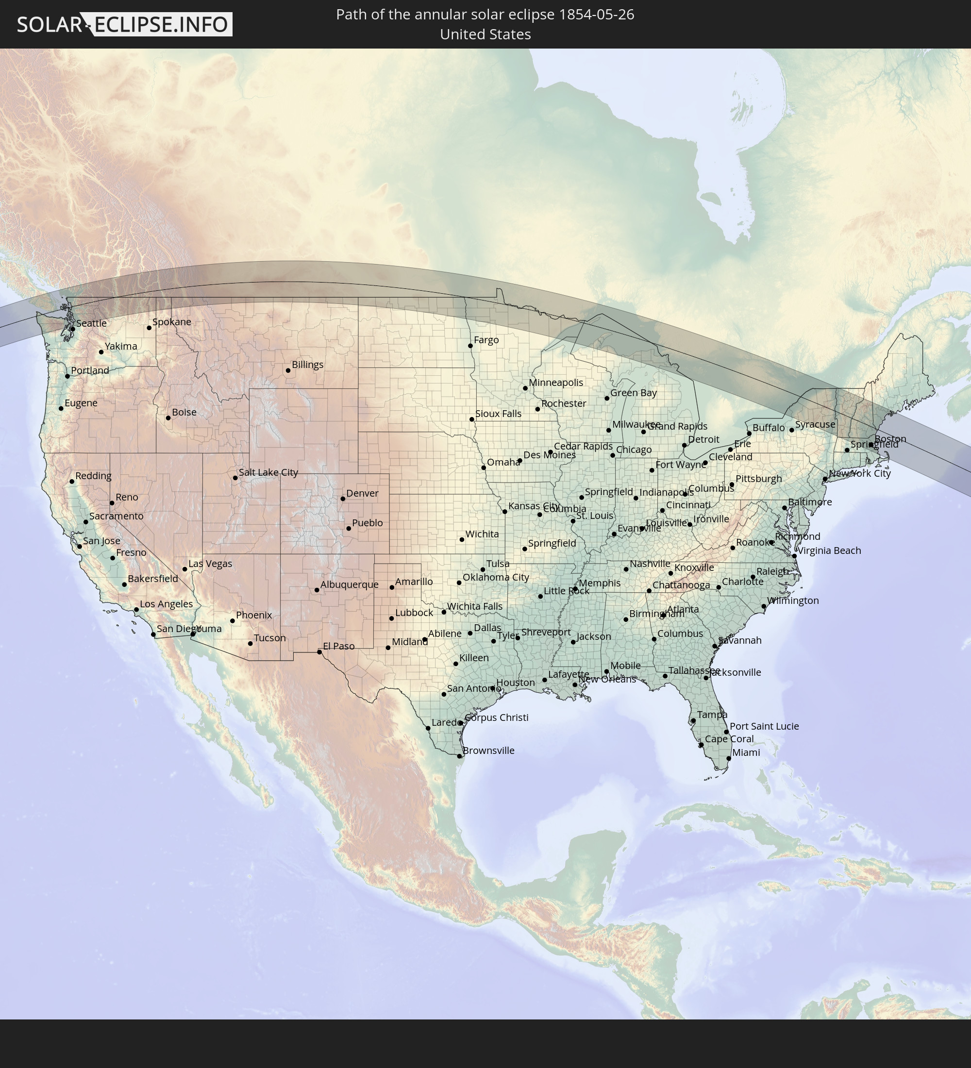 United States
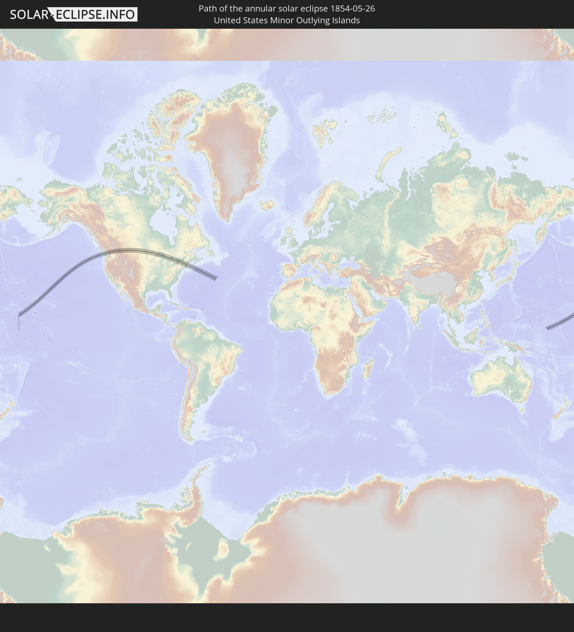 United States Minor Outlying Islands
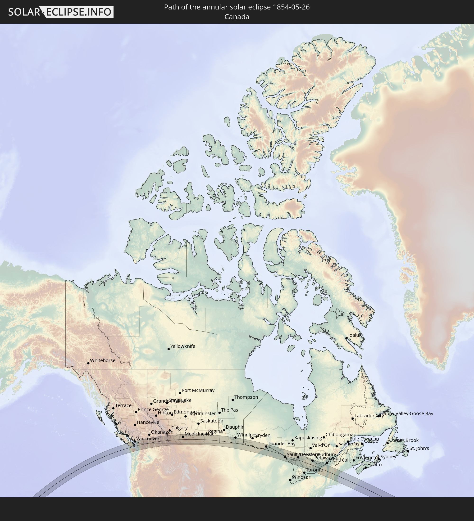 Canada
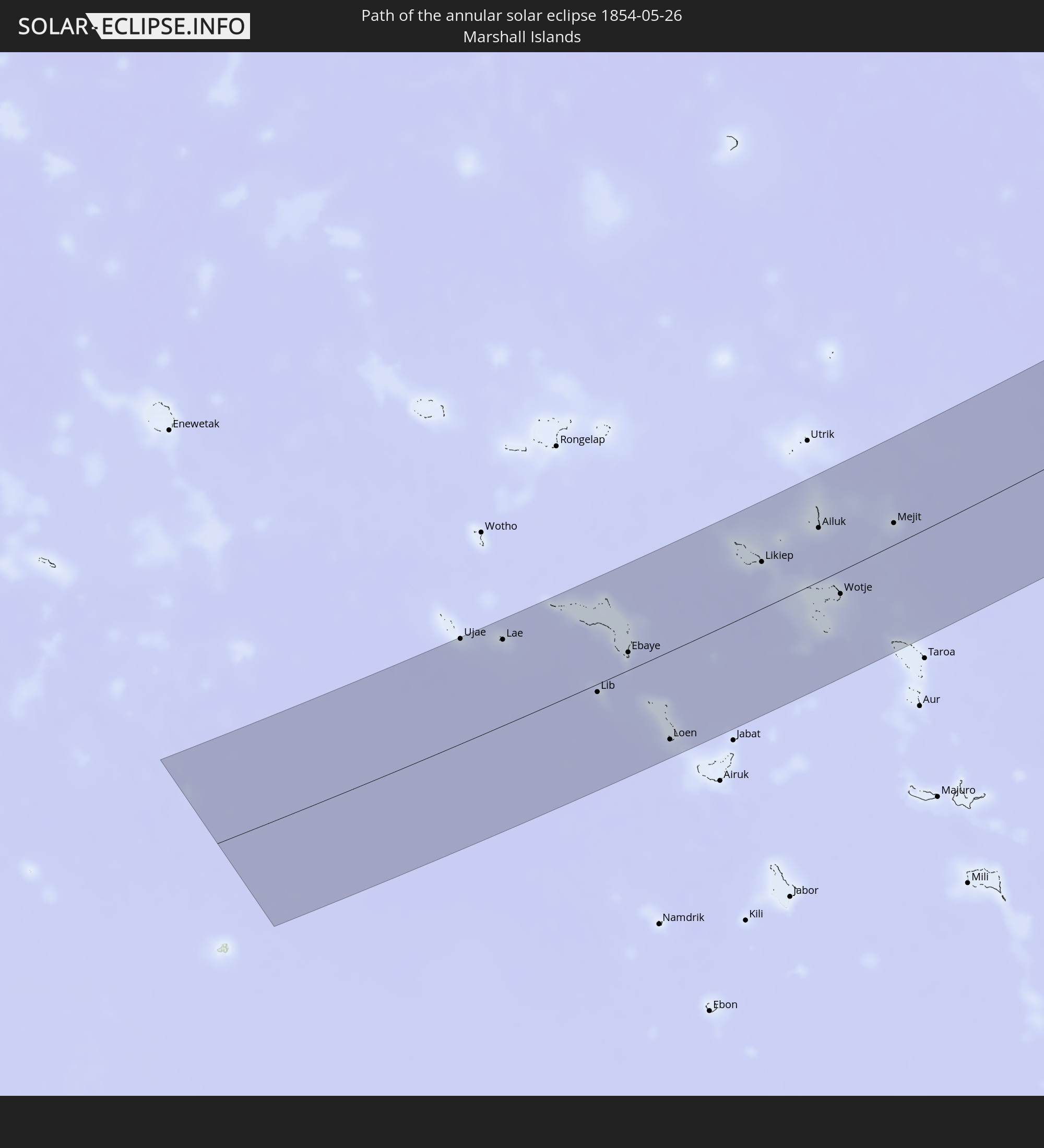 Marshall Islands
In den folgenden Ländern ist die Sonnenfinsternis partiell zu sehen
 Russia
 Fiji
Fiji
 United States
 United States Minor Outlying Islands
 Wallis and Futuna
 Tonga
Tonga
 Kiribati
 Samoa
Samoa
 Tokelau
 American Samoa
 Niue
Niue
 Cook Islands
 Canada
 Mexico
 Greenland
 Guatemala
 El Salvador
 Honduras
 Belize
 Nicaragua
 Cuba
Cuba
 Panama
 Colombia
 Cayman Islands
 The Bahamas
 Jamaica
 Haiti
Haiti
 Venezuela
 Turks and Caicos Islands
 Dominican Republic
 Aruba
Aruba
 Puerto Rico
 Bermuda
 Saint Pierre and Miquelon
 Iceland
 Svalbard and Jan Mayen
 Norway
 Sweden
 Finland
 China
China
 Japan
Japan
 North Korea
 Marshall Islands
 Tuvalu
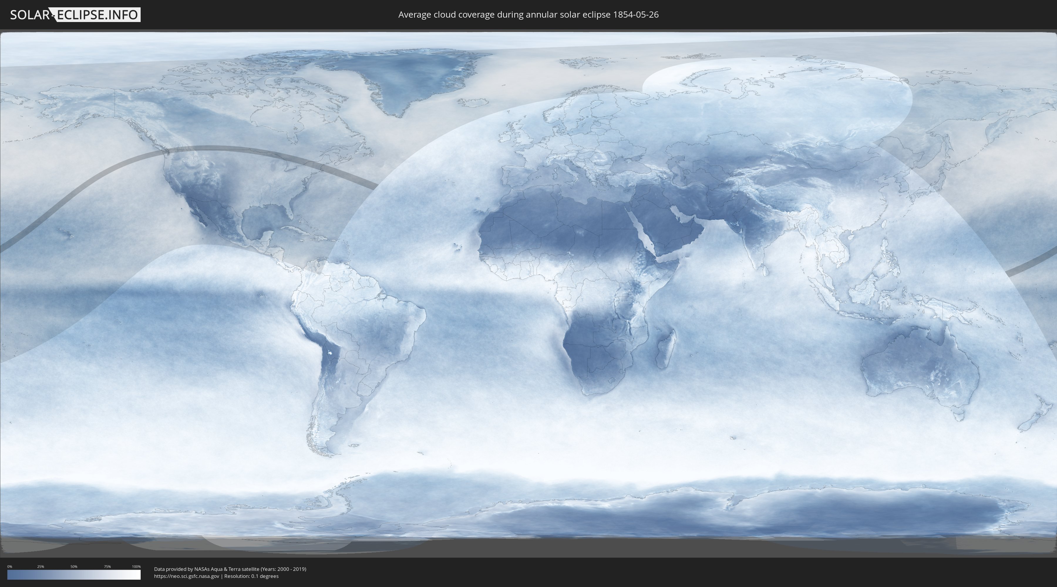
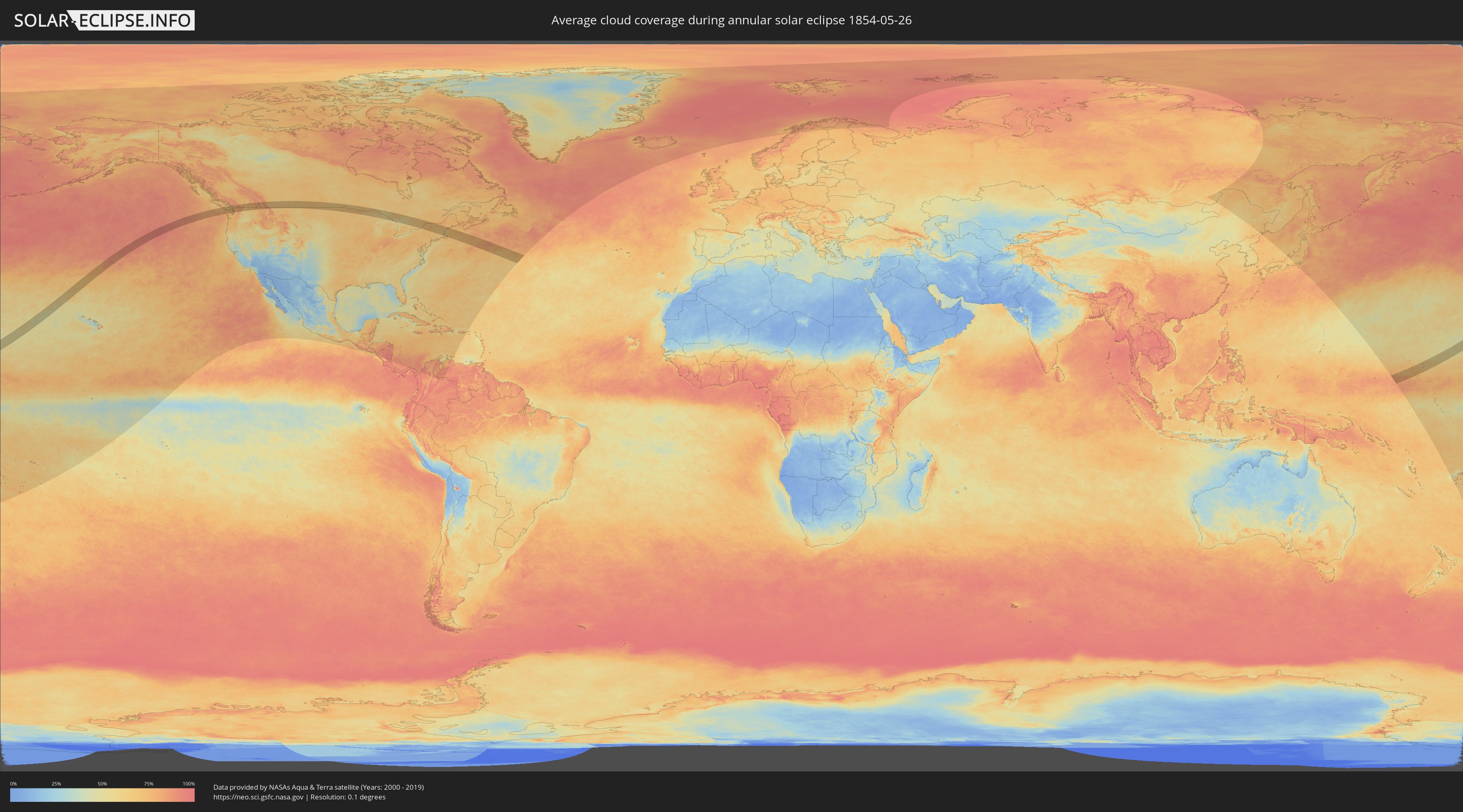
How will be the weather during the annular solar eclipse on 05/26/1854?
Where is the best place to see the annular solar eclipse of 05/26/1854?
The following maps show the average cloud coverage for the day of the annular solar eclipse.
With the help of these maps, it is possible to find the place along the eclipse path, which has the best
chance of a cloudless sky.
Nevertheless, you should consider local circumstances and inform about the weather of your chosen
observation site.
The data is provided by NASAs satellites
AQUA and TERRA.
The cloud maps are averaged over a period of 19 years (2000 - 2019).
Detailed country maps
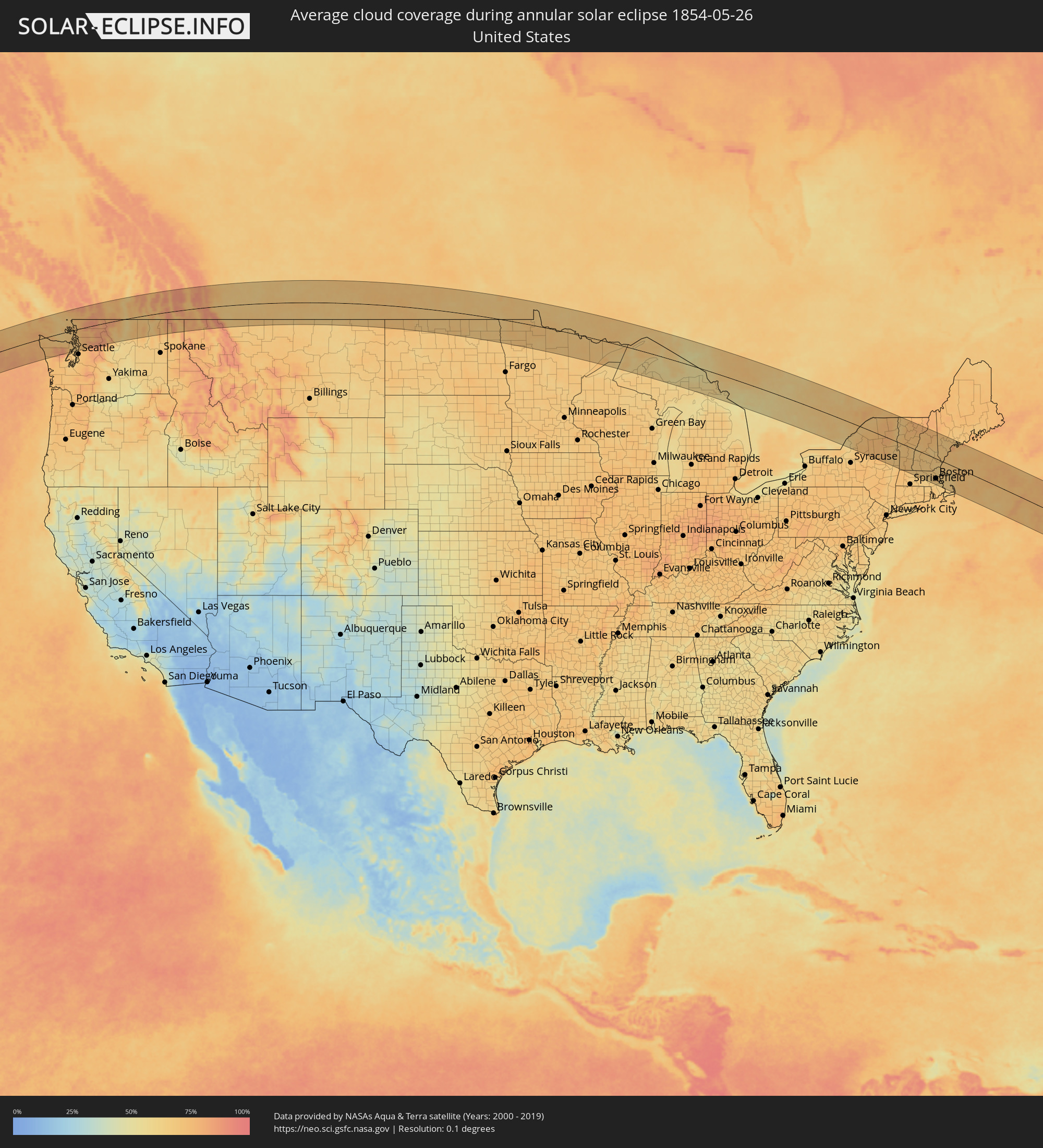 United States
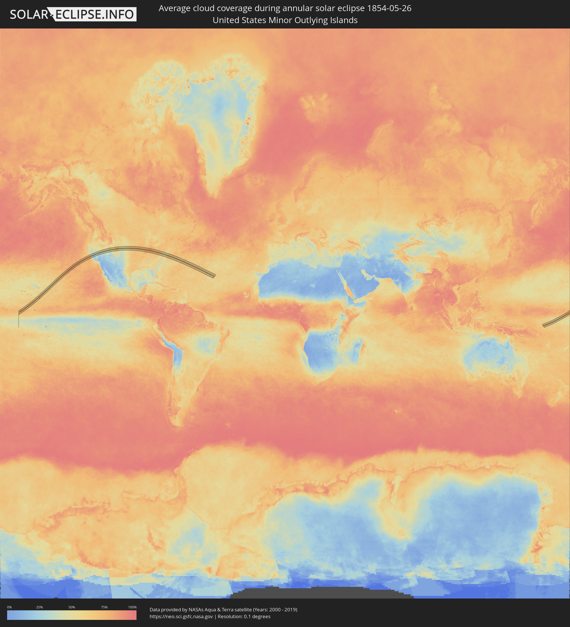 United States Minor Outlying Islands
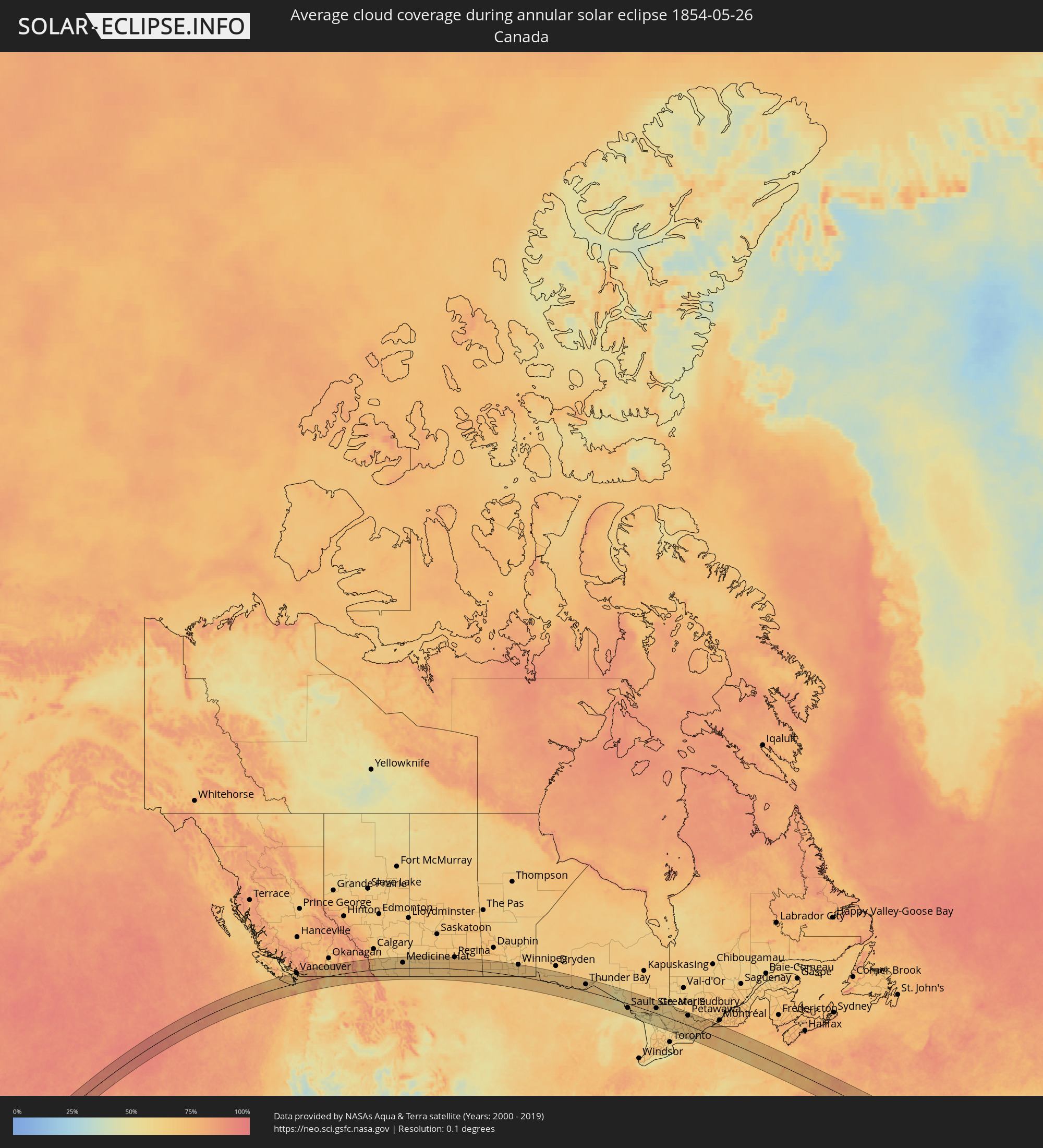 Canada
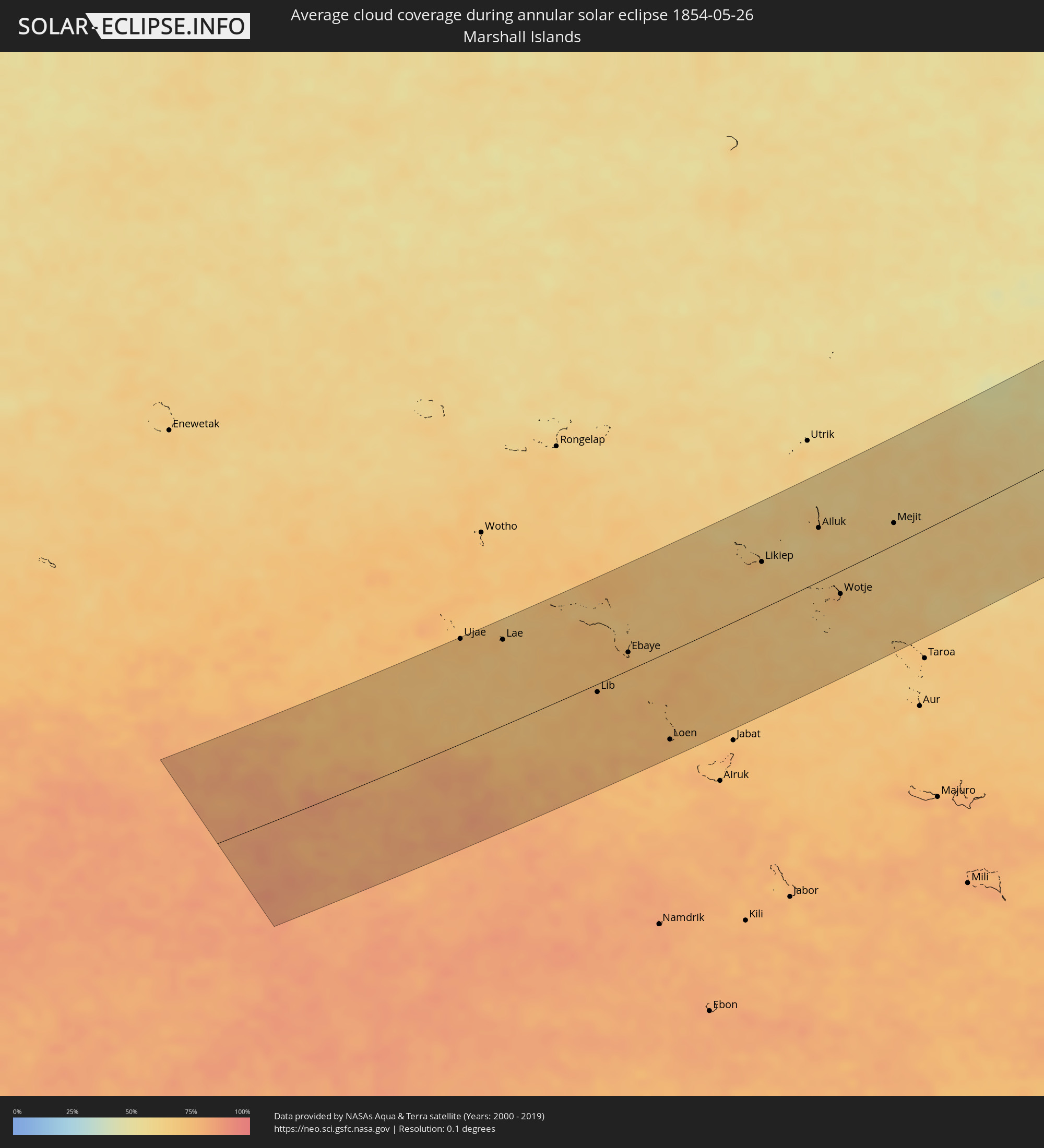 Marshall Islands
Cities inside the path of the eclipse
The following table shows all locations with a population of more than 5,000 inside the eclipse path. Cities which have more than 100,000 inhabitants are marked bold. A click at the locations opens a detailed map.
| City | Type | Eclipse duration | Local time of max. eclipse | Distance to central line | Ø Cloud coverage |
|
Nanaimo, British Columbia
|
annular | - | 13:19:33 UTC-08:00 | 89 km | 64% |
|
Ladysmith, British Columbia
|
annular | - | 13:19:44 UTC-08:00 | 68 km | 69% |
|
Duncan, British Columbia
|
annular | - | 13:19:53 UTC-08:00 | 43 km | 68% |
|
North Cowichan, British Columbia
|
annular | - | 13:19:55 UTC-08:00 | 49 km | 68% |
|
Langford, British Columbia
|
annular | - | 13:20:09 UTC-08:00 | 3 km | 64% |
|
Colwood, British Columbia
|
annular | - | 13:20:10 UTC-08:00 | 1 km | 64% |
|
Port Angeles, Washington
|
annular | - | 13:20:11 UTC-08:00 | 34 km | 72% |
|
North Saanich, British Columbia
|
annular | - | 13:20:22 UTC-08:00 | 25 km | 67% |
|
Victoria, British Columbia
|
annular | - | 13:20:23 UTC-08:00 | 1 km | 65% |
|
Oak Bay, British Columbia
|
annular | - | 13:20:31 UTC-08:00 | 0 km | 63% |
|
West End, British Columbia
|
annular | - | 13:21:03 UTC-08:00 | 87 km | 71% |
|
Vancouver, British Columbia
|
annular | - | 13:21:04 UTC-08:00 | 83 km | 68% |
|
Ladner, British Columbia
|
annular | - | 13:21:06 UTC-08:00 | 65 km | 68% |
|
North Vancouver, British Columbia
|
annular | - | 13:21:10 UTC-08:00 | 89 km | 71% |
|
New Westminster, British Columbia
|
annular | - | 13:21:26 UTC-08:00 | 74 km | 71% |
|
Port Moody, British Columbia
|
annular | - | 13:21:33 UTC-08:00 | 82 km | 74% |
|
Anmore, British Columbia
|
annular | - | 13:21:34 UTC-08:00 | 85 km | 74% |
|
Surrey, British Columbia
|
annular | - | 13:21:34 UTC-08:00 | 62 km | 67% |
|
Port Townsend, Washington
|
annular | - | 13:21:26 UTC-08:00 | 46 km | 67% |
|
Pitt Meadows, British Columbia
|
annular | - | 13:21:50 UTC-08:00 | 72 km | 73% |
|
Langley, British Columbia
|
annular | - | 13:21:52 UTC-08:00 | 58 km | 71% |
|
Poulsbo, Washington
|
annular | - | 13:21:33 UTC-08:00 | 89 km | 67% |
|
Oak Harbor, Washington
|
annular | - | 13:21:42 UTC-08:00 | 29 km | 67% |
|
Walnut Grove, British Columbia
|
annular | - | 13:21:55 UTC-08:00 | 65 km | 74% |
|
Anacortes, Washington
|
annular | - | 13:21:49 UTC-08:00 | 6 km | 68% |
|
Maple Ridge, British Columbia
|
annular | - | 13:21:59 UTC-08:00 | 70 km | 74% |
|
Langley, British Columbia
|
annular | - | 13:21:59 UTC-08:00 | 55 km | 73% |
|
Camano, Washington
|
annular | - | 13:21:53 UTC-08:00 | 44 km | 68% |
|
Bellingham, Washington
|
annular | - | 13:22:06 UTC-08:00 | 19 km | 69% |
|
Aldergrove, British Columbia
|
annular | - | 13:22:12 UTC-08:00 | 51 km | 75% |
|
Lynden, Washington
|
annular | - | 13:22:12 UTC-08:00 | 38 km | 70% |
|
Edmonds, Washington
|
annular | - | 13:22:05 UTC-08:00 | 86 km | 66% |
|
Mount Vernon, Washington
|
annular | - | 13:22:18 UTC-08:00 | 21 km | 73% |
|
Abbotsford, British Columbia
|
annular | - | 13:22:35 UTC-08:00 | 47 km | 75% |
|
Everett, Washington
|
annular | - | 13:22:27 UTC-08:00 | 71 km | 71% |
|
North Creek, Washington
|
annular | - | 13:22:28 UTC-08:00 | 89 km | 72% |
|
Arlington, Washington
|
annular | - | 13:22:39 UTC-08:00 | 48 km | 75% |
|
Monroe, Washington
|
annular | - | 13:22:52 UTC-08:00 | 88 km | 73% |
|
Chilliwack, British Columbia
|
annular | - | 13:23:09 UTC-08:00 | 54 km | 75% |
|
Penticton, British Columbia
|
annular | - | 13:27:23 UTC-08:00 | 53 km | 64% |
|
Trail, British Columbia
|
annular | - | 13:30:41 UTC-08:00 | 12 km | 66% |
|
Castlegar, British Columbia
|
annular | - | 13:30:43 UTC-08:00 | 10 km | 71% |
|
Nelson, British Columbia
|
annular | - | 13:31:21 UTC-08:00 | 28 km | 79% |
|
Cranbrook, British Columbia
|
annular | - | 14:00:04 UTC-07:33 | 13 km | 71% |
|
Lethbridge, Alberta
|
annular | - | 14:04:50 UTC-07:33 | 16 km | 66% |
|
Medicine Hat, Alberta
|
annular | - | 14:08:00 UTC-07:33 | 45 km | 68% |
|
Swift Current, Saskatchewan
|
annular | - | 14:47:21 UTC-06:58 | 71 km | 68% |
|
Moose Jaw, Saskatchewan
|
annular | - | 14:50:25 UTC-06:58 | 89 km | 71% |
|
Weyburn, Saskatchewan
|
annular | - | 14:53:16 UTC-06:58 | 14 km | 70% |
|
Estevan, Saskatchewan
|
annular | - | 14:54:53 UTC-06:58 | 40 km | 71% |
|
Brandon, Manitoba
|
annular | - | 15:56:34 UTC-06:00 | 63 km | 66% |
|
Portage la Prairie, Manitoba
|
annular | - | 15:58:20 UTC-06:00 | 93 km | 65% |
|
Winnipeg, Manitoba
|
annular | - | 15:59:41 UTC-06:00 | 97 km | 71% |
|
Steinbach, Manitoba
|
annular | - | 16:00:35 UTC-06:00 | 63 km | 70% |
|
Thief River Falls, Minnesota
|
annular | - | 16:02:41 UTC-06:00 | 85 km | 69% |
|
Virginia, Minnesota
|
annular | - | 16:07:06 UTC-06:00 | 95 km | 69% |
|
Thunder Bay, Ontario
|
annular | - | 17:08:57 UTC-05:00 | 58 km | 64% |
|
Marquette, Michigan
|
annular | - | 17:12:44 UTC-05:00 | 102 km | 61% |
|
Sault Ste. Marie, Michigan
|
annular | - | 17:14:57 UTC-05:00 | 38 km | 62% |
|
Sault Ste. Marie, Ontario
|
annular | - | 17:14:56 UTC-05:00 | 36 km | 62% |
|
Elliot Lake, Ontario
|
annular | - | 17:16:10 UTC-05:00 | 9 km | 64% |
|
Rayside-Balfour, Ontario
|
annular | - | 17:16:40 UTC-05:00 | 51 km | 63% |
|
Greater Sudbury, Ontario
|
annular | - | 17:16:57 UTC-05:00 | 44 km | 63% |
|
Midland, Ontario
|
annular | - | 17:19:46 UTC-05:00 | 108 km | 58% |
|
North Bay, Ontario
|
annular | - | 17:17:56 UTC-05:00 | 66 km | 60% |
|
Orillia, Ontario
|
annular | - | 17:20:10 UTC-05:00 | 111 km | 59% |
|
Huntsville, Ontario
|
annular | - | 17:19:20 UTC-05:00 | 29 km | 62% |
|
Quinte West, Ontario
|
annular | - | 17:21:32 UTC-05:00 | 103 km | 63% |
|
Belleville, Ontario
|
annular | - | 17:21:38 UTC-05:00 | 99 km | 66% |
|
Petawawa, Ontario
|
annular | - | 17:19:27 UTC-05:00 | 83 km | 64% |
|
Pembroke, Ontario
|
annular | - | 17:19:37 UTC-05:00 | 80 km | 65% |
|
Greater Napanee, Ontario
|
annular | - | 17:21:42 UTC-05:00 | 78 km | 66% |
|
Kingston, Ontario
|
annular | - | 17:21:54 UTC-05:00 | 66 km | 61% |
|
Arnprior, Ontario
|
annular | - | 17:20:25 UTC-05:00 | 62 km | 69% |
|
Carleton Place, Ontario
|
annular | - | 17:20:52 UTC-05:00 | 37 km | 69% |
|
Smiths Falls, Ontario
|
annular | - | 17:21:13 UTC-05:00 | 17 km | 71% |
|
Watertown, New York
|
annular | - | 17:22:26 UTC-05:00 | 76 km | 68% |
|
Bells Corners, Ontario
|
annular | - | 17:20:45 UTC-05:00 | 65 km | 75% |
|
le Plateau, Quebec
|
annular | - | 17:20:37 UTC-05:00 | 79 km | 71% |
|
Fort Drum, New York
|
annular | - | 17:22:23 UTC-05:00 | 63 km | 71% |
|
Ottawa, Ontario
|
annular | - | 17:20:41 UTC-05:00 | 79 km | 71% |
|
Brockville, Ontario
|
annular | - | 17:21:44 UTC-05:00 | 5 km | 68% |
|
Val-des-Monts, Quebec
|
annular | - | 17:20:23 UTC-05:00 | 105 km | 65% |
|
Ogdensburg, New York
|
annular | - | 17:21:40 UTC-05:00 | 11 km | 68% |
|
Clarence-Rockland, Ontario
|
annular | - | 17:20:38 UTC-05:00 | 105 km | 68% |
|
Potsdam, New York
|
annular | - | 17:21:52 UTC-05:00 | 24 km | 69% |
|
Massena, New York
|
annular | - | 17:21:34 UTC-05:00 | 53 km | 67% |
|
Cornwall, Ontario
|
annular | - | 17:21:31 UTC-05:00 | 67 km | 66% |
|
Les Coteaux, Quebec
|
annular | - | 17:21:19 UTC-05:00 | 110 km | 69% |
|
Salaberry-de-Valleyfield, Quebec
|
annular | - | 17:21:24 UTC-05:00 | 109 km | 69% |
|
Saratoga Springs, New York
|
annular | - | 17:24:14 UTC-05:00 | 102 km | 69% |
|
Glens Falls, New York
|
annular | - | 17:24:00 UTC-05:00 | 75 km | 67% |
|
Plattsburgh, New York
|
annular | - | 17:22:18 UTC-05:00 | 74 km | 69% |
|
Burlington, Vermont
|
annular | - | 17:22:39 UTC-05:00 | 58 km | 66% |
|
Bennington, Vermont
|
annular | - | 17:24:39 UTC-05:00 | 105 km | 70% |
|
Rutland, Vermont
|
annular | - | 17:23:48 UTC-05:00 | 23 km | 69% |
|
Barre, Vermont
|
annular | - | 17:23:11 UTC-05:00 | 52 km | 73% |
|
Claremont, New Hampshire
|
annular | - | 17:24:15 UTC-05:00 | 27 km | 65% |
|
Keene, New Hampshire
|
annular | - | 17:24:49 UTC-05:00 | 70 km | 67% |
|
Lebanon, New Hampshire
|
annular | - | 17:23:56 UTC-05:00 | 3 km | 65% |
|
Gardner, Massachusetts
|
annular | - | 17:25:19 UTC-05:00 | 98 km | 66% |
|
Leominster, Massachusetts
|
annular | - | 17:25:26 UTC-05:00 | 95 km | 65% |
|
Weare, New Hampshire
|
annular | - | 17:24:44 UTC-05:00 | 36 km | 68% |
|
Milford, New Hampshire
|
annular | - | 17:25:04 UTC-05:00 | 60 km | 66% |
|
Hudson, Massachusetts
|
annular | - | 17:25:38 UTC-05:00 | 102 km | 63% |
|
Concord, New Hampshire
|
annular | - | 17:24:38 UTC-05:00 | 18 km | 67% |
|
Laconia, New Hampshire
|
annular | - | 17:24:15 UTC-05:00 | 17 km | 69% |
|
Nashua, New Hampshire
|
annular | - | 17:25:12 UTC-05:00 | 61 km | 68% |
|
Manchester, New Hampshire
|
annular | - | 17:24:55 UTC-05:00 | 37 km | 67% |
|
Acton, Massachusetts
|
annular | - | 17:25:33 UTC-05:00 | 89 km | 65% |
|
Framingham, Massachusetts
|
annular | - | 17:25:48 UTC-05:00 | 109 km | 64% |
|
Lowell, Massachusetts
|
annular | - | 17:25:23 UTC-05:00 | 70 km | 66% |
|
Derry Village, New Hampshire
|
annular | - | 17:25:04 UTC-05:00 | 43 km | 68% |
|
Needham, Massachusetts
|
annular | - | 17:25:50 UTC-05:00 | 103 km | 66% |
|
Woburn, Massachusetts
|
annular | - | 17:25:37 UTC-05:00 | 80 km | 66% |
|
Haverhill, Massachusetts
|
annular | - | 17:25:16 UTC-05:00 | 47 km | 66% |
|
Boston, Massachusetts
|
annular | - | 17:25:46 UTC-05:00 | 89 km | 68% |
|
Brockton, Massachusetts
|
annular | - | 17:26:07 UTC-05:00 | 116 km | 65% |
|
Middleton, Massachusetts
|
annular | - | 17:25:30 UTC-05:00 | 64 km | 62% |
|
Lynn, Massachusetts
|
annular | - | 17:25:40 UTC-05:00 | 75 km | 67% |
|
Weymouth, Massachusetts
|
annular | - | 17:25:58 UTC-05:00 | 99 km | 64% |
|
Amesbury, Massachusetts
|
annular | - | 17:25:11 UTC-05:00 | 34 km | 63% |
|
Dover, New Hampshire
|
annular | - | 17:24:47 UTC-05:00 | 2 km | 67% |
|
Hanover, Massachusetts
|
annular | - | 17:26:07 UTC-05:00 | 106 km | 64% |
|
Sanford, Maine
|
annular | - | 17:24:30 UTC-05:00 | 30 km | 71% |
|
Portsmouth, New Hampshire
|
annular | - | 17:24:57 UTC-05:00 | 7 km | 65% |
|
Kingston, Massachusetts
|
annular | - | 17:26:17 UTC-05:00 | 115 km | 66% |
|
Gloucester, Massachusetts
|
annular | - | 17:25:32 UTC-05:00 | 50 km | 68% |
|
York Beach, Maine
|
annular | - | 17:24:52 UTC-05:00 | 8 km | 69% |
|
Wells Beach Station, Maine
|
annular | - | 17:24:41 UTC-05:00 | 24 km | 69% |
|
Biddeford, Maine
|
annular | - | 17:24:30 UTC-05:00 | 46 km | 69% |
|
Portland, Maine
|
annular | - | 17:24:19 UTC-05:00 | 70 km | 68% |
|
Lewiston, Maine
|
annular | - | 17:23:47 UTC-05:00 | 116 km | 69% |
|
Brunswick, Maine
|
annular | - | 17:24:03 UTC-05:00 | 105 km | 72% |
|
Ujae, Ujae Atoll
|
annular | - | 05:56:22 UTC+11:00 | 125 km | 71% |
|
Lae, Lae Atoll
|
annular | - | 05:56:13 UTC+11:00 | 102 km | 70% |
|
Lib, Lib Island
|
annular | - | 05:55:18 UTC+11:00 | 10 km | 76% |
|
Ebaye, Kwajalein Atoll
|
annular | - | 05:55:42 UTC+11:00 | 21 km | 76% |
|
Loen, Namu Atoll
|
annular | - | 05:54:31 UTC+11:00 | 104 km | 76% |
|
Likiep, Likiep Atoll
|
annular | - | 05:56:31 UTC+11:00 | 54 km | 66% |
|
Ailuk, Ailuk Atoll
|
annular | - | 05:56:50 UTC+11:00 | 62 km | 65% |
|
Wotje, Wotje Atoll
|
annular | - | 05:55:56 UTC+11:00 | 27 km | 76% |
|
Mejit, Mejit Island
|
annular | - | 05:56:46 UTC+11:00 | 25 km | 67% |