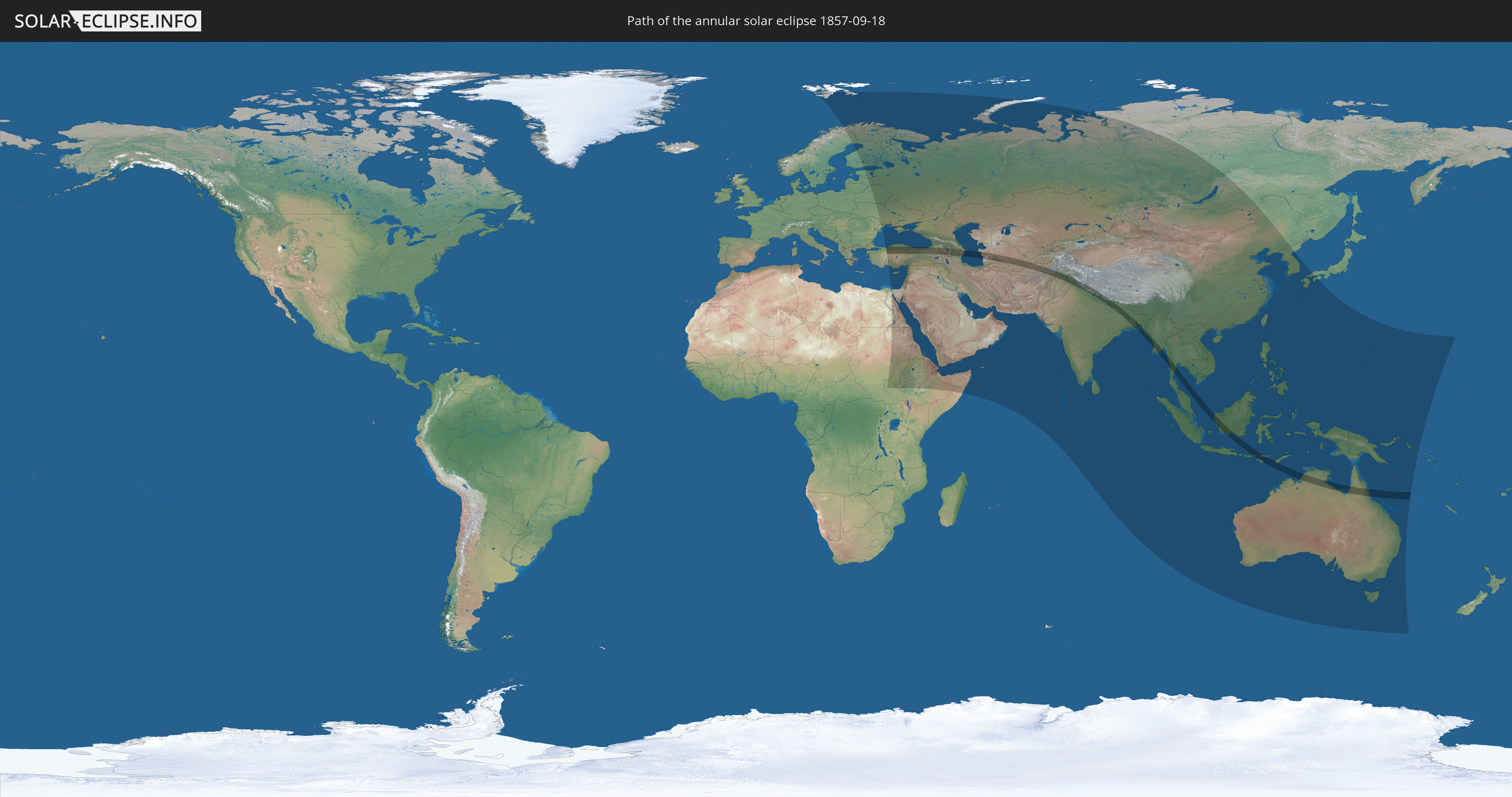
Annular solar eclipse of 09/18/1857
| Day of week: | Friday |
| Maximum duration of eclipse: | 03m34s |
| Maximum width of eclipse path: | 125 km |
| Saros cycle: | 132 |
| Coverage: | 96.6% |
| Magnitude: | 0.9659 |
| Gamma: | 0.1912 |
Wo kann man die Sonnenfinsternis vom 09/18/1857 sehen?
Die Sonnenfinsternis am 09/18/1857 kann man in 78 Ländern als partielle Sonnenfinsternis beobachten.
Der Finsternispfad verläuft durch 15 Länder. Nur in diesen Ländern ist sie als annular Sonnenfinsternis zu sehen.
In den folgenden Ländern ist die Sonnenfinsternis annular zu sehen
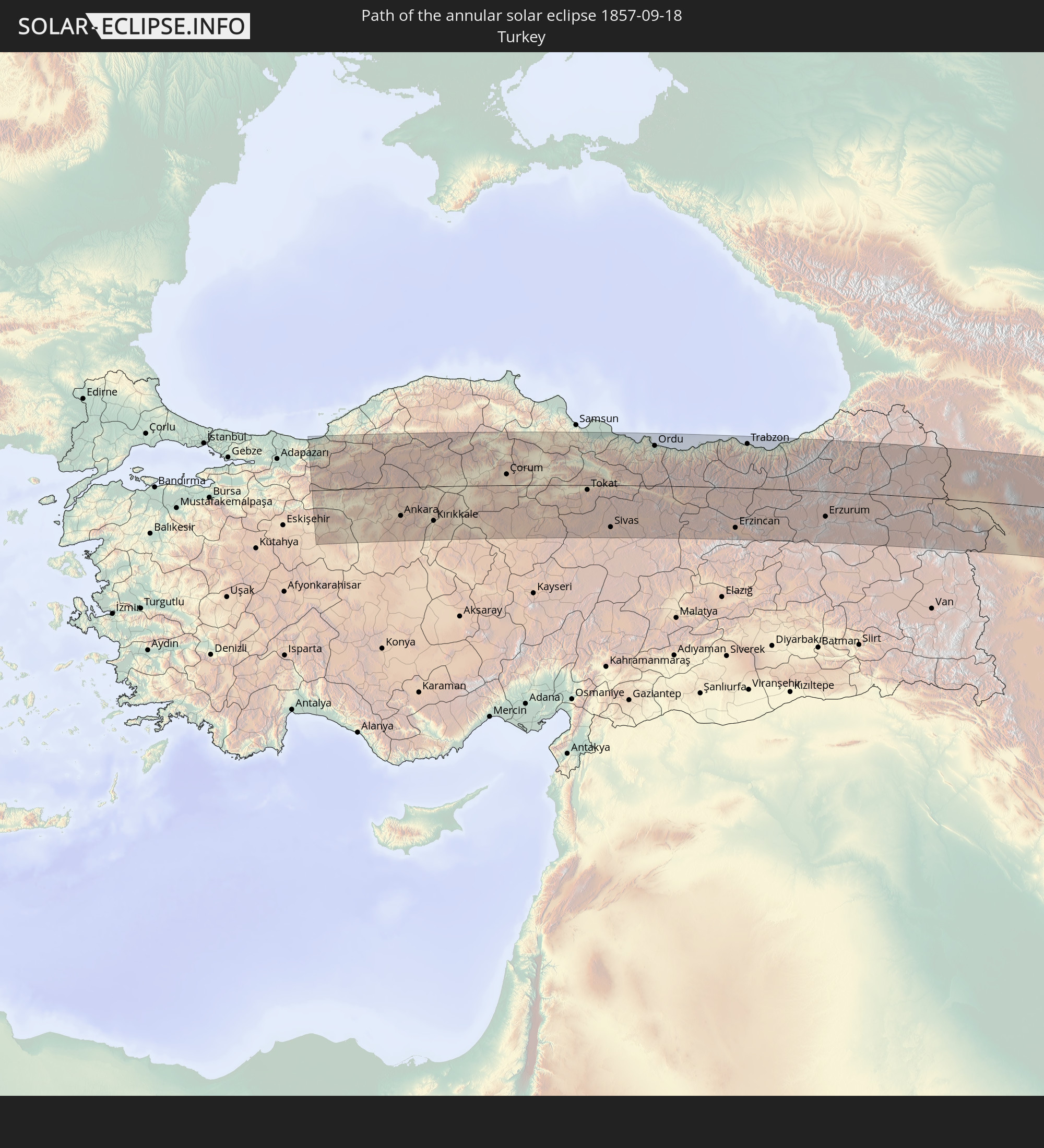 Turkey
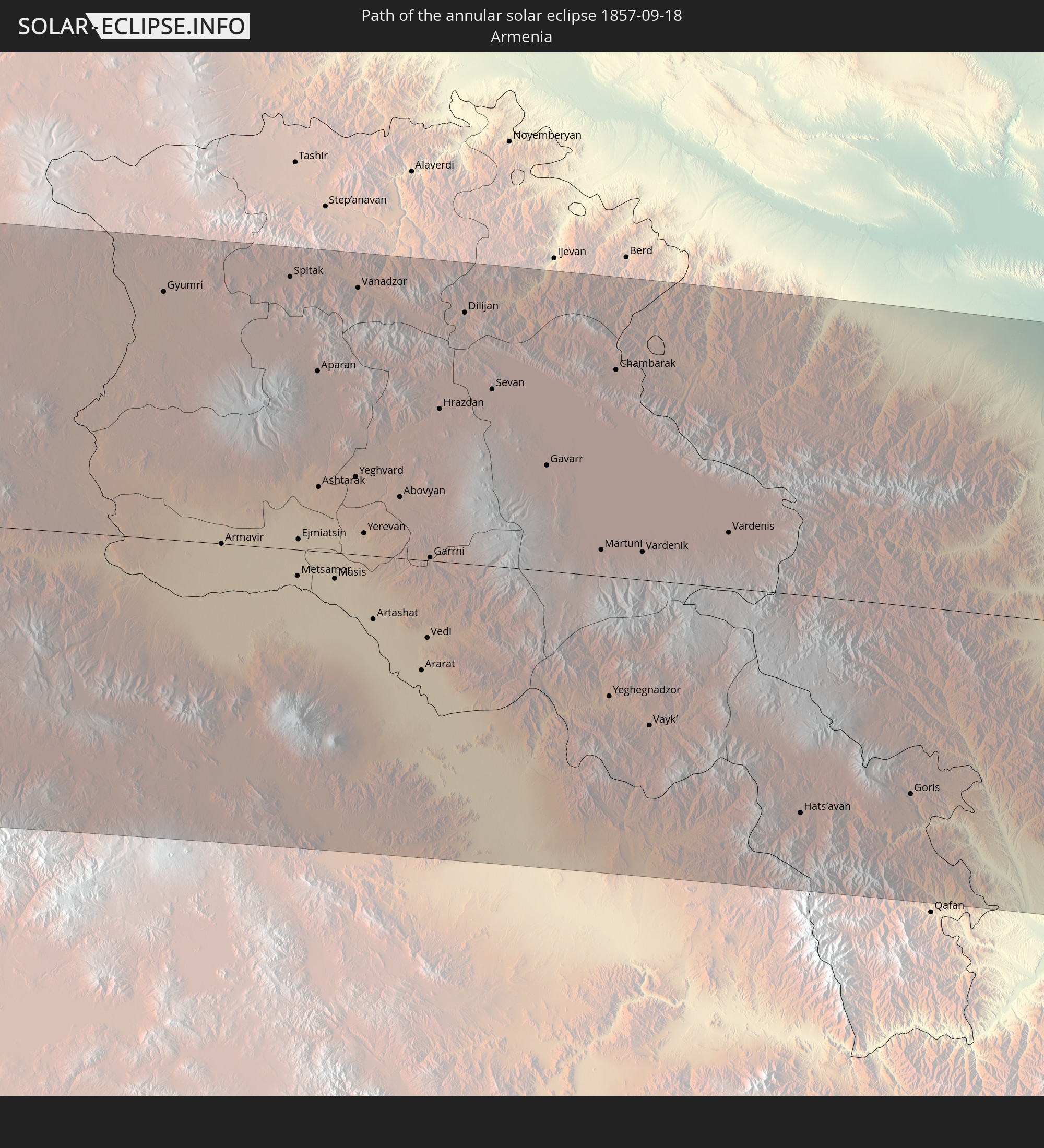 Armenia
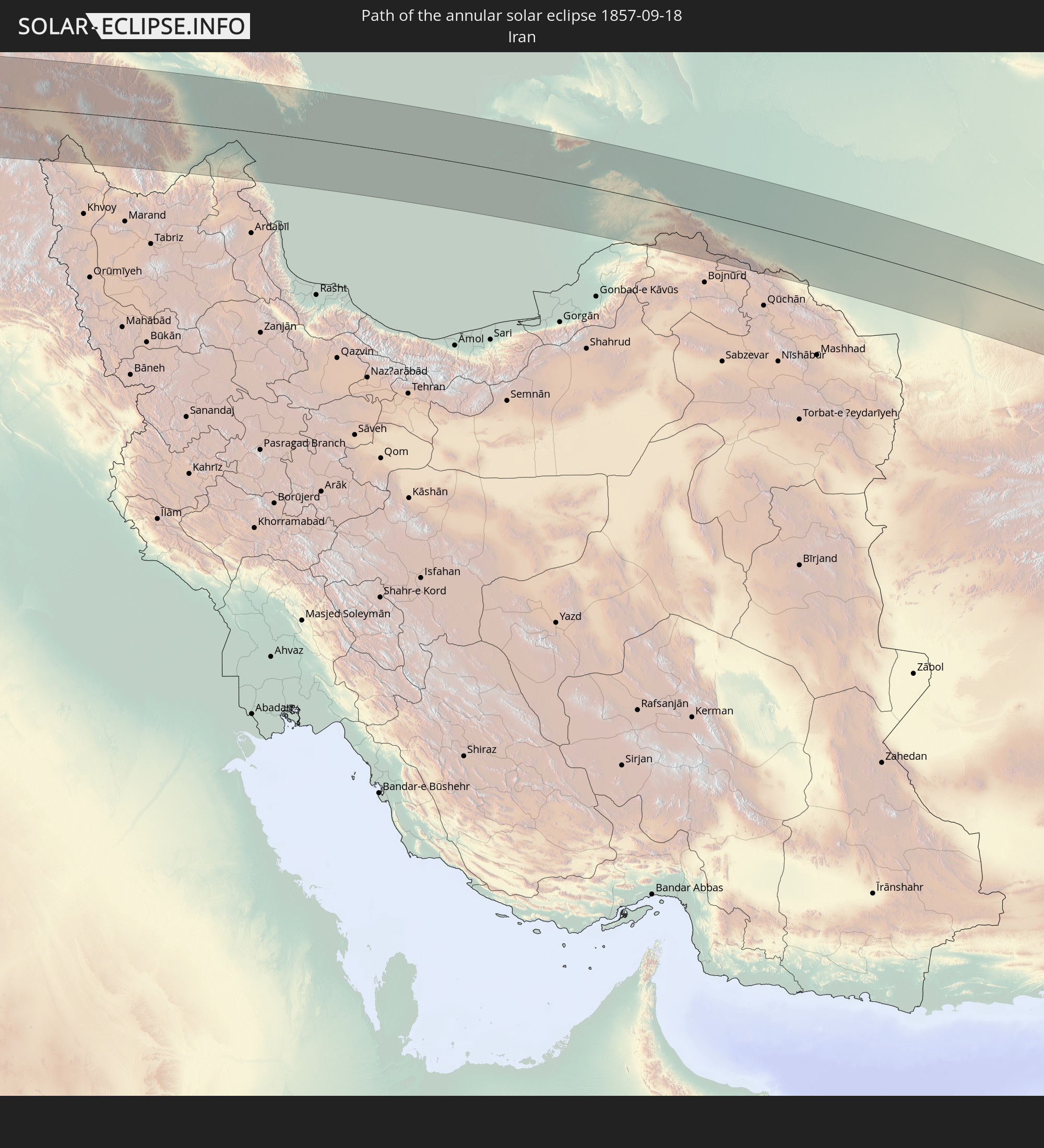 Iran
Iran
 Azerbaijan
 Turkmenistan
 Afghanistan
 Pakistan
 India
India
 China
China
 Nepal
Nepal
 Bangladesh
 Myanmar
 Indonesia
 Thailand
 Australia
In den folgenden Ländern ist die Sonnenfinsternis partiell zu sehen
 Russia
 Svalbard and Jan Mayen
 Norway
 Sweden
 Finland
 Latvia
 Estonia
 Sudan
Sudan
 Ukraine
 Belarus
 Egypt
Egypt
 Turkey
 Moldova
 Cyprus
 Ethiopia
 State of Palestine
 Israel
 Saudi Arabia
 Jordan
 Lebanon
 Syria
Syria
 Eritrea
 Iraq
Iraq
 Georgia
 Somalia
 Djibouti
 Yemen
Yemen
 Armenia
 Iran
Iran
 Azerbaijan
 Kazakhstan
 Kuwait
 Bahrain
 Qatar
Qatar
 United Arab Emirates
 Oman
Oman
 Turkmenistan
 Uzbekistan
 Afghanistan
 Pakistan
 Tajikistan
 India
India
 Kyrgyzstan
 British Indian Ocean Territory
 Maldives
 China
China
 Sri Lanka
 Nepal
Nepal
 Mongolia
 Bangladesh
 Bhutan
 Myanmar
 Indonesia
 Cocos Islands
 Thailand
 Malaysia
 Laos
Laos
 Vietnam
 Cambodia
 Singapore
 Christmas Island
 Australia
 Macau
Macau
 Hong Kong
 Brunei
 Taiwan
 Philippines
 Japan
Japan
 East Timor
 North Korea
 South Korea
 Palau
Palau
 Federated States of Micronesia
 Papua New Guinea
 Guam
Guam
 Northern Mariana Islands
 Solomon Islands
 Marshall Islands
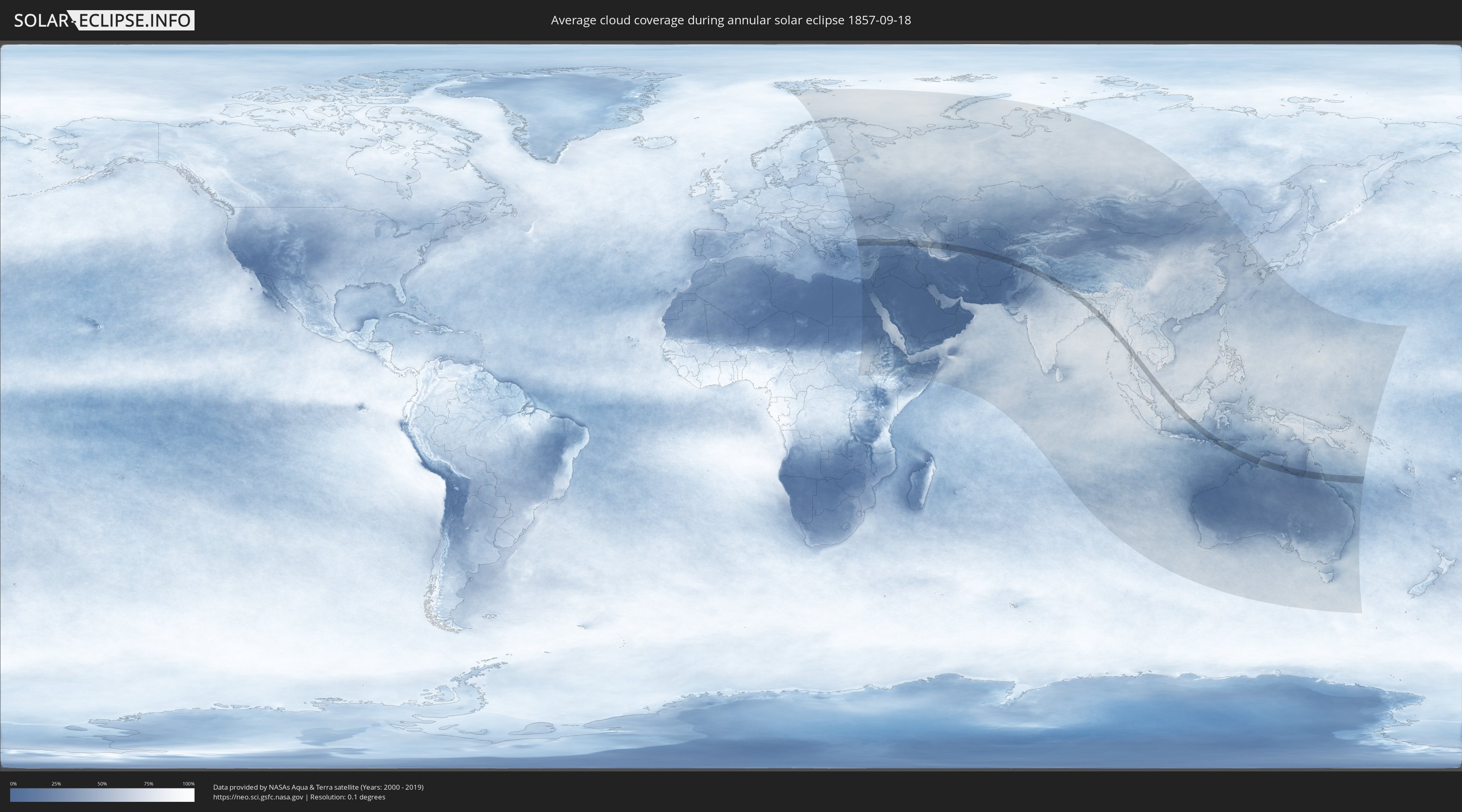
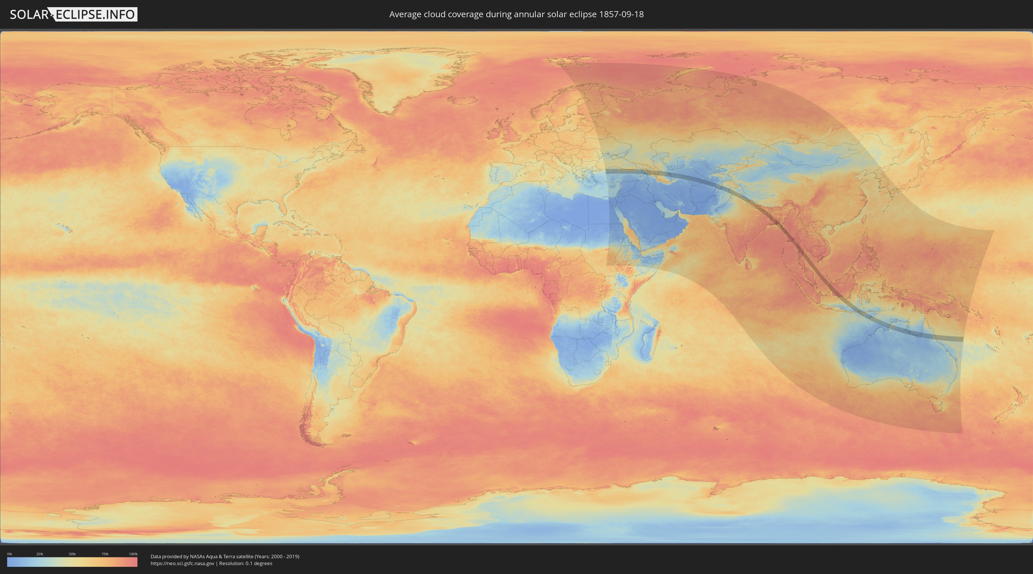
How will be the weather during the annular solar eclipse on 09/18/1857?
Where is the best place to see the annular solar eclipse of 09/18/1857?
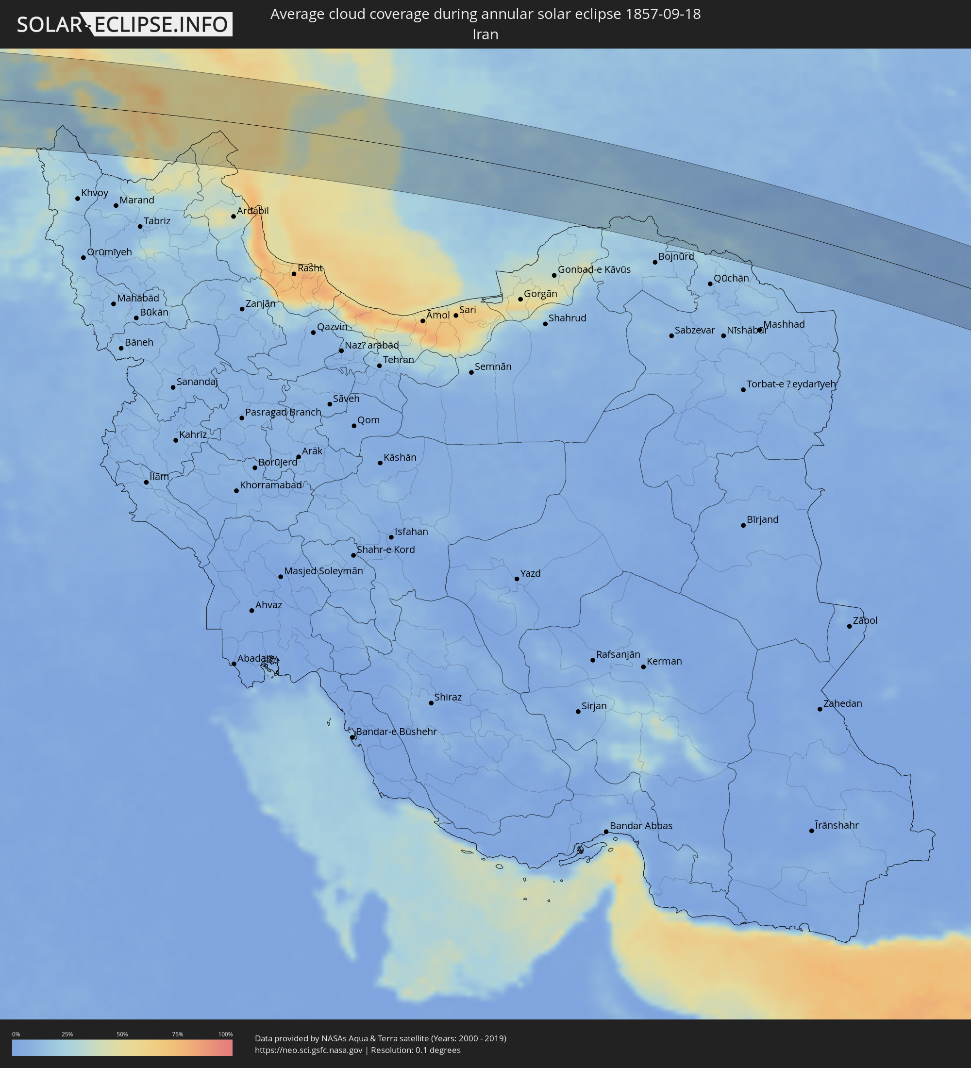
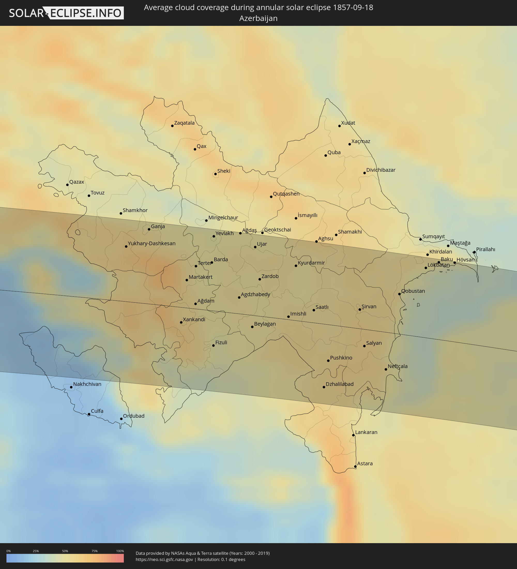
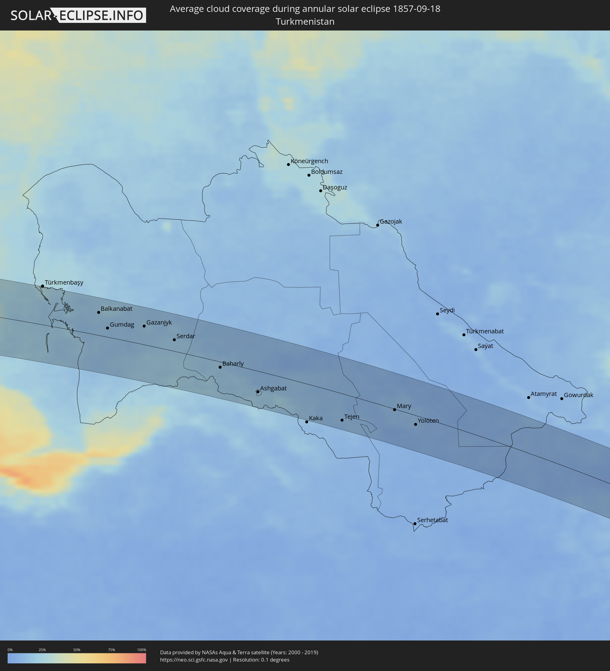
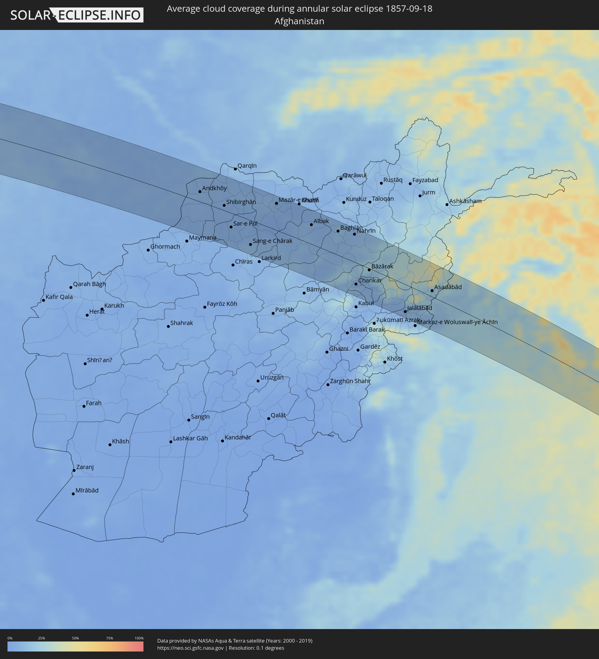
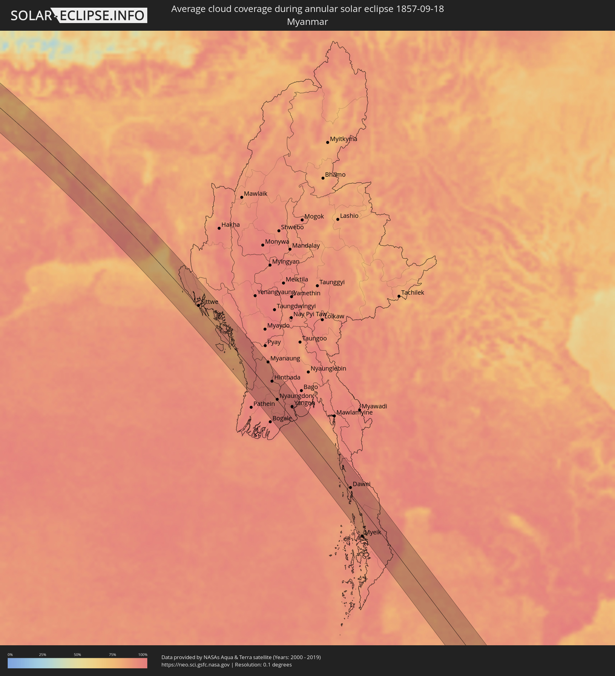
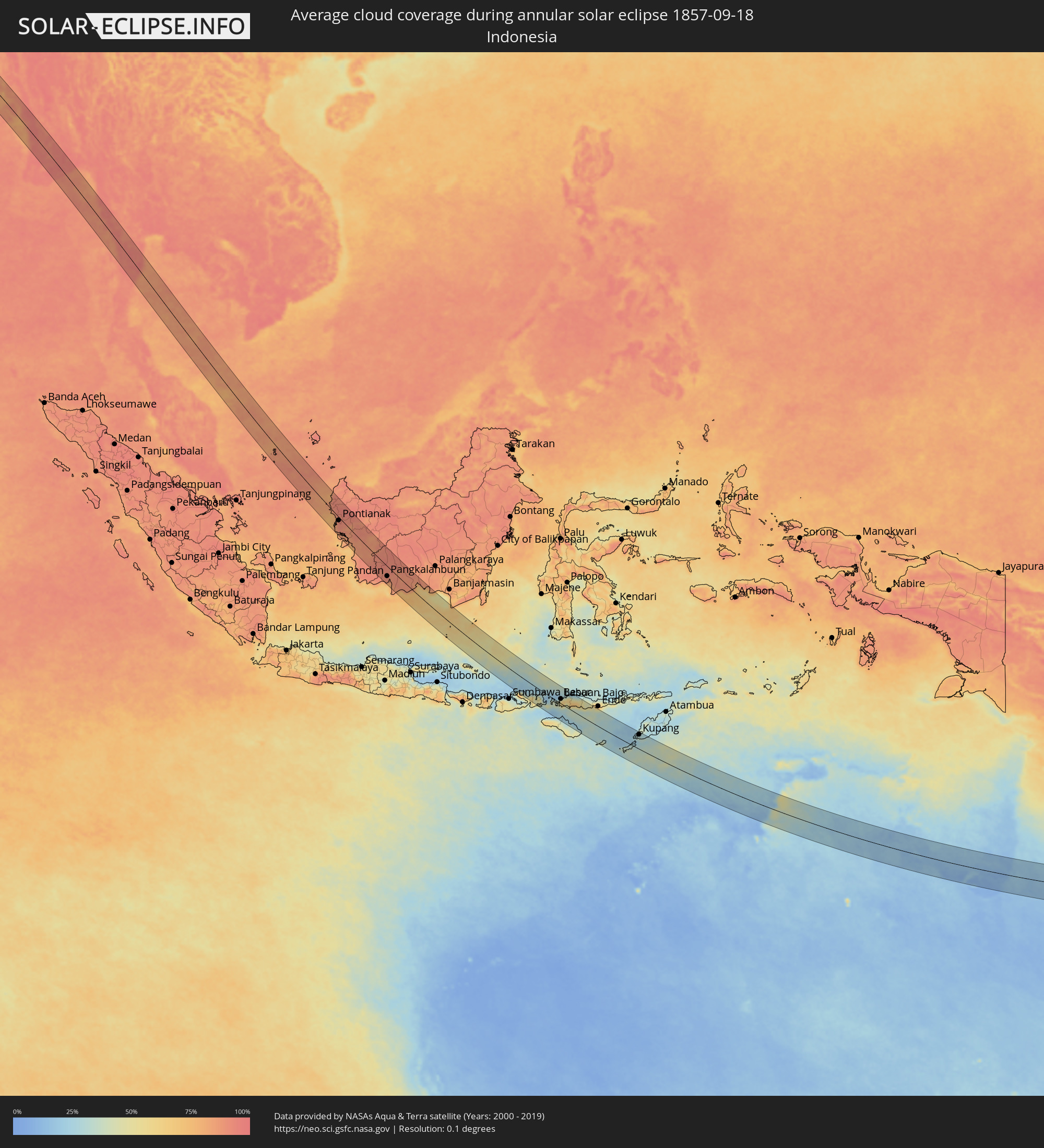
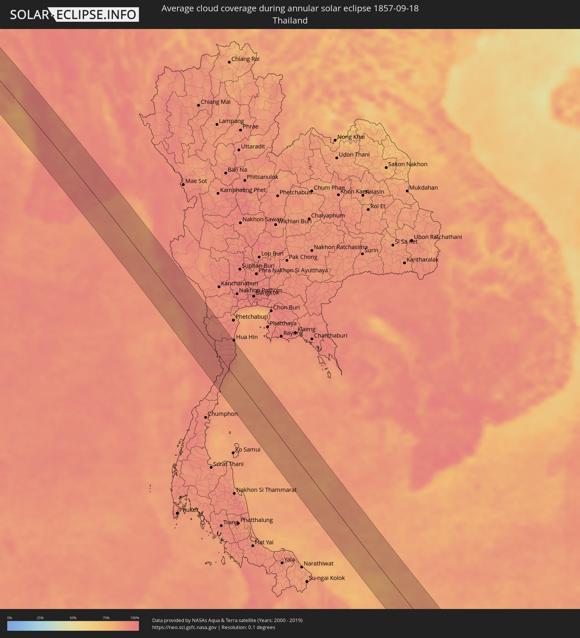
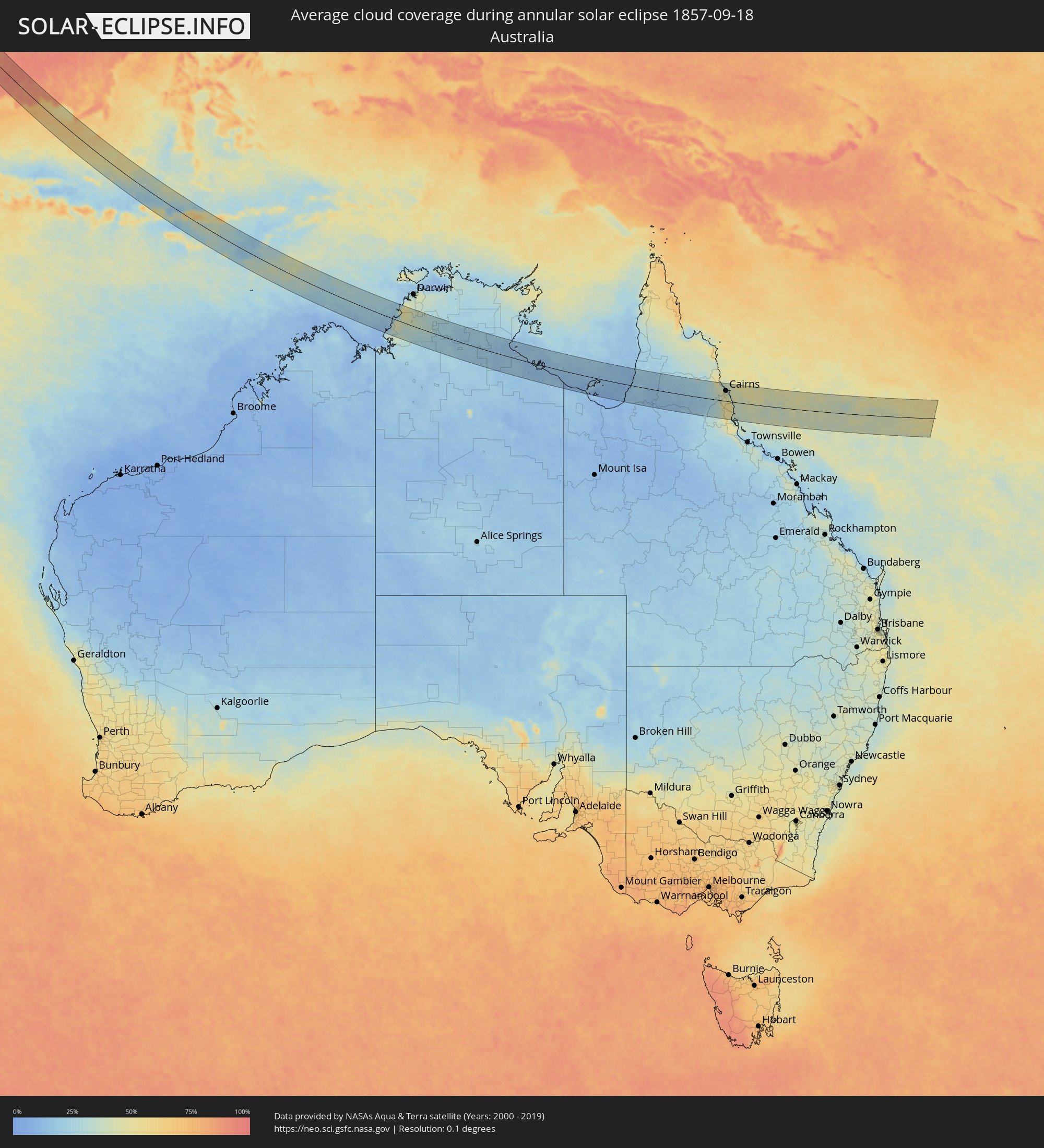
The following maps show the average cloud coverage for the day of the annular solar eclipse.
With the help of these maps, it is possible to find the place along the eclipse path, which has the best
chance of a cloudless sky.
Nevertheless, you should consider local circumstances and inform about the weather of your chosen
observation site.
The data is provided by NASAs satellites
AQUA and TERRA.
The cloud maps are averaged over a period of 19 years (2000 - 2019).
Detailed country maps
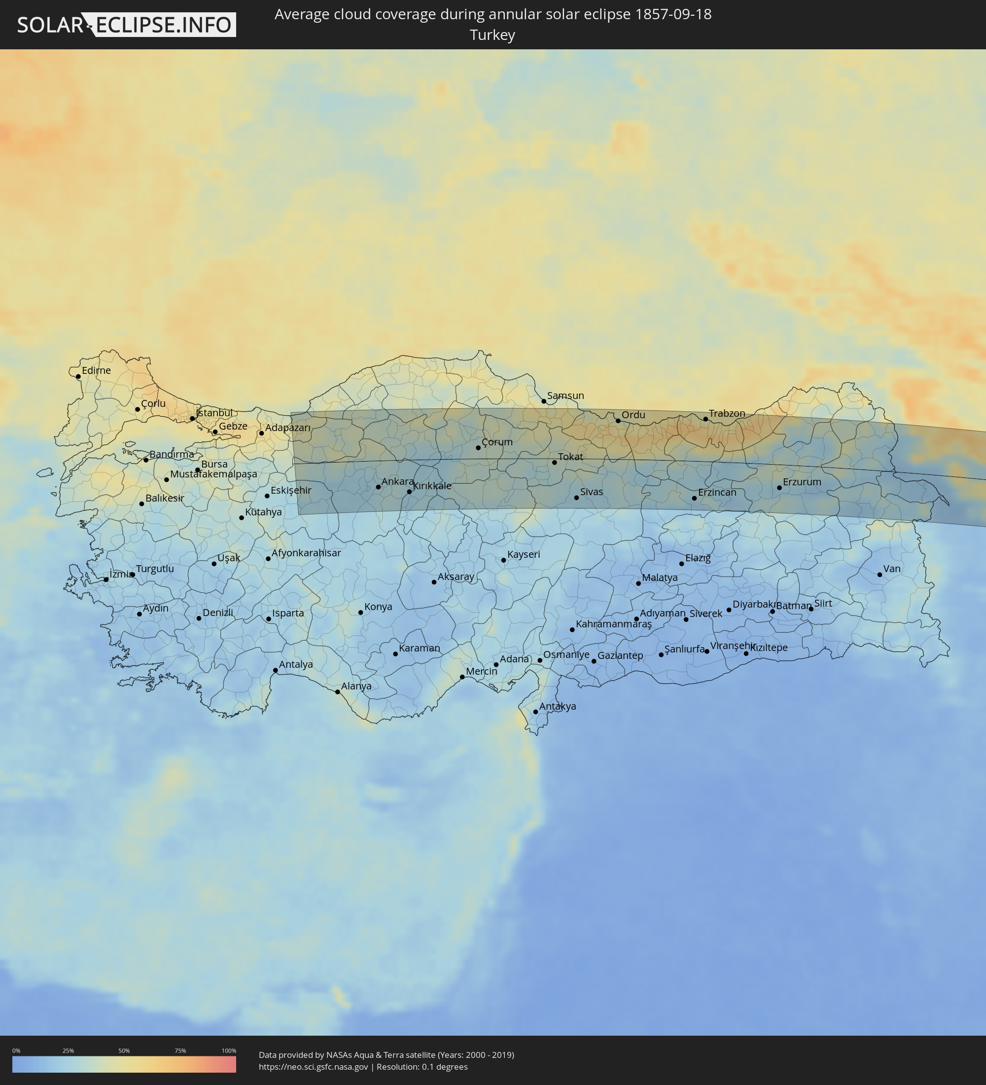 Turkey
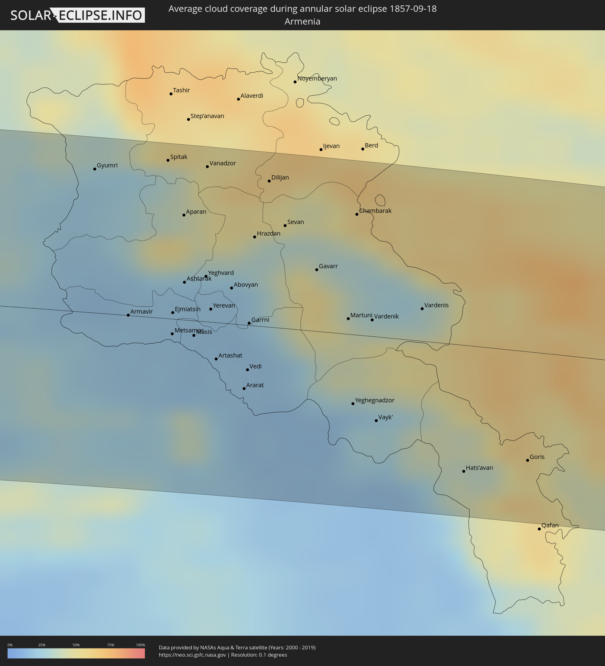 Armenia
 Iran
Iran
 Azerbaijan
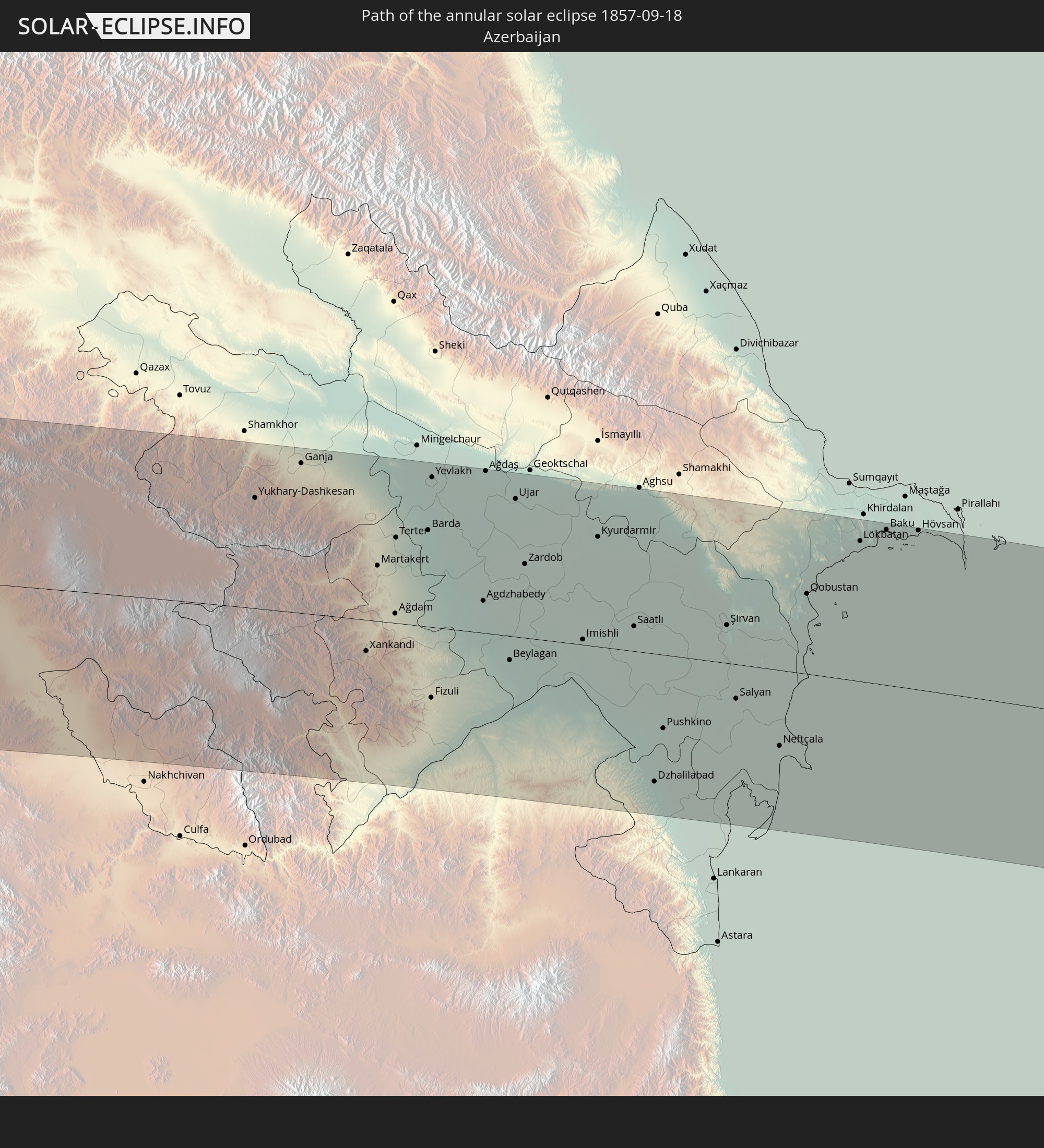
 Turkmenistan
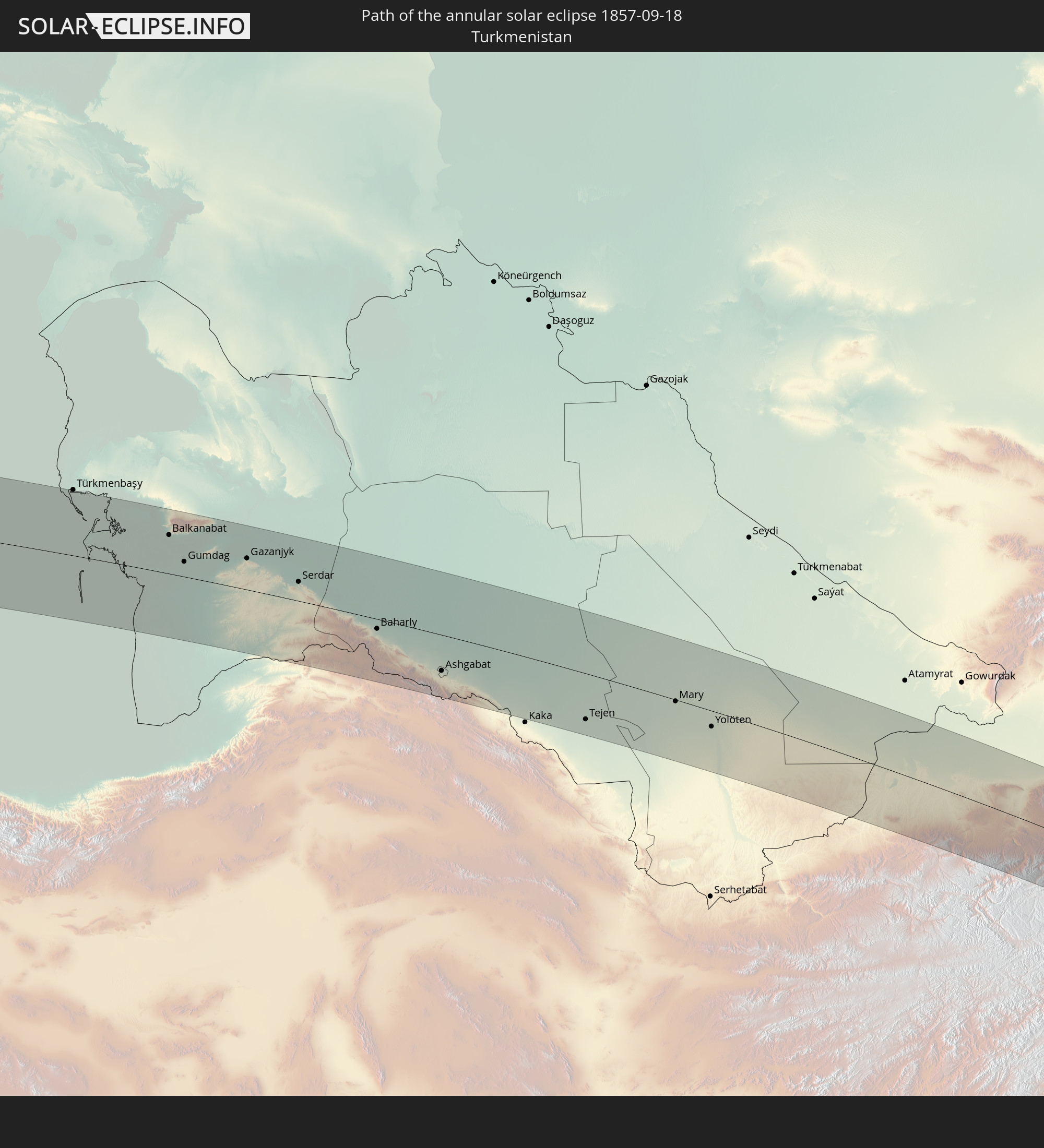
 Afghanistan
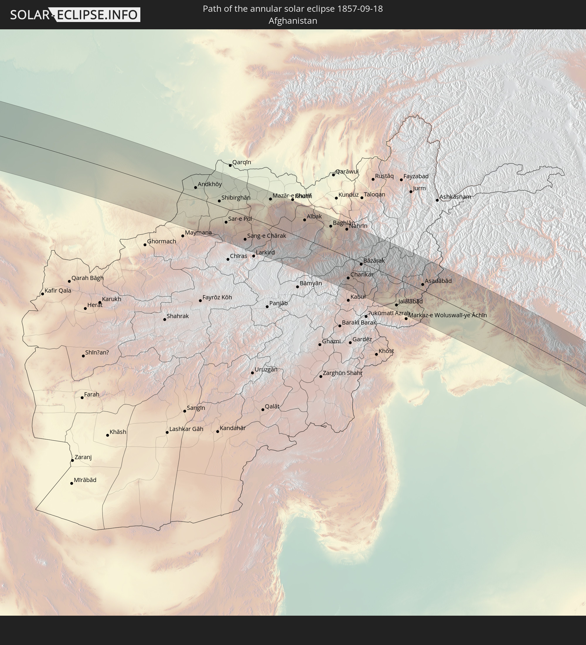
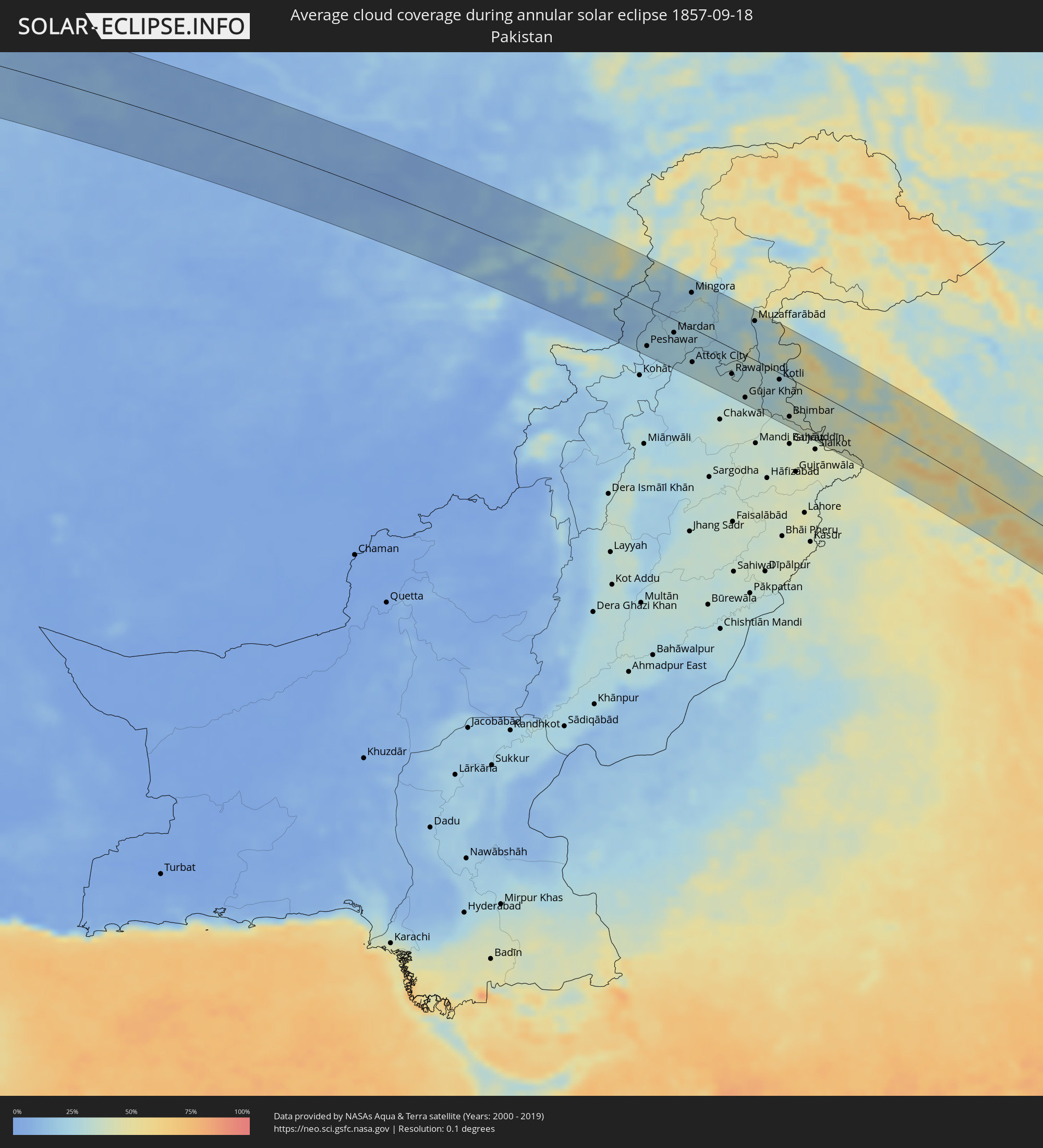 Pakistan
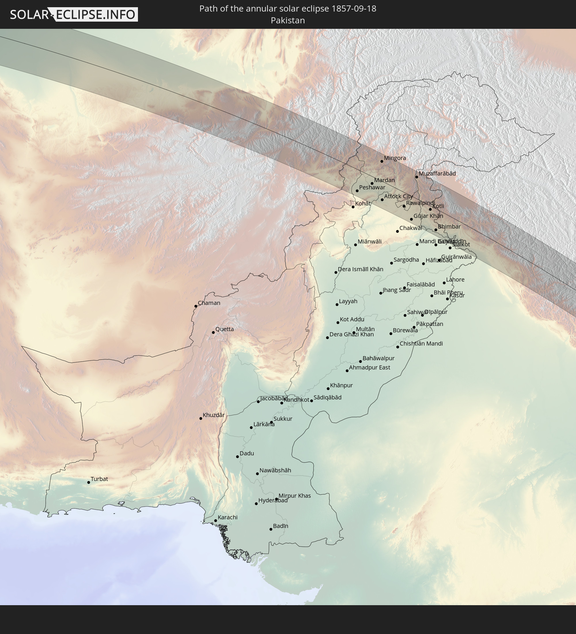
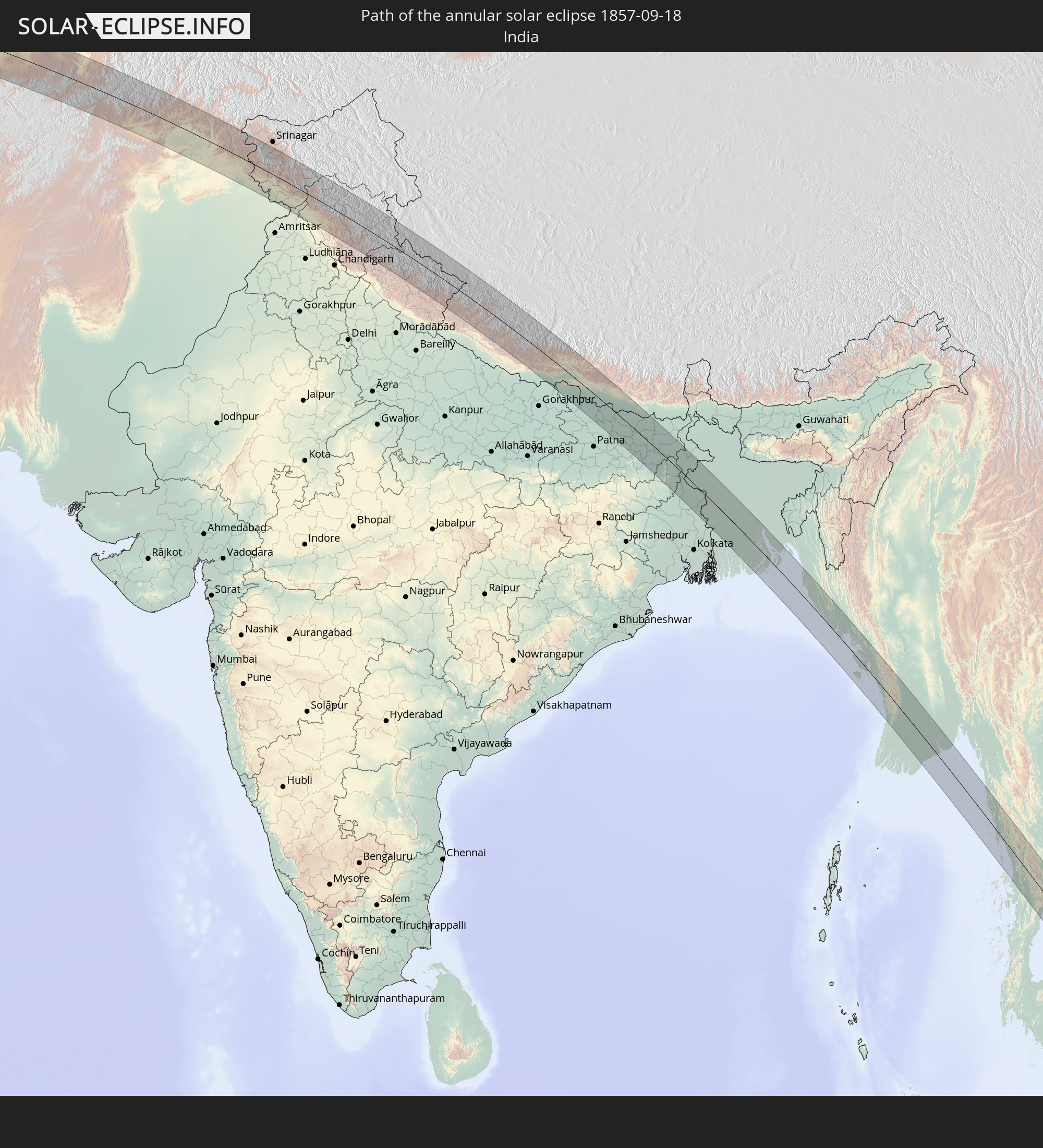
 India
India
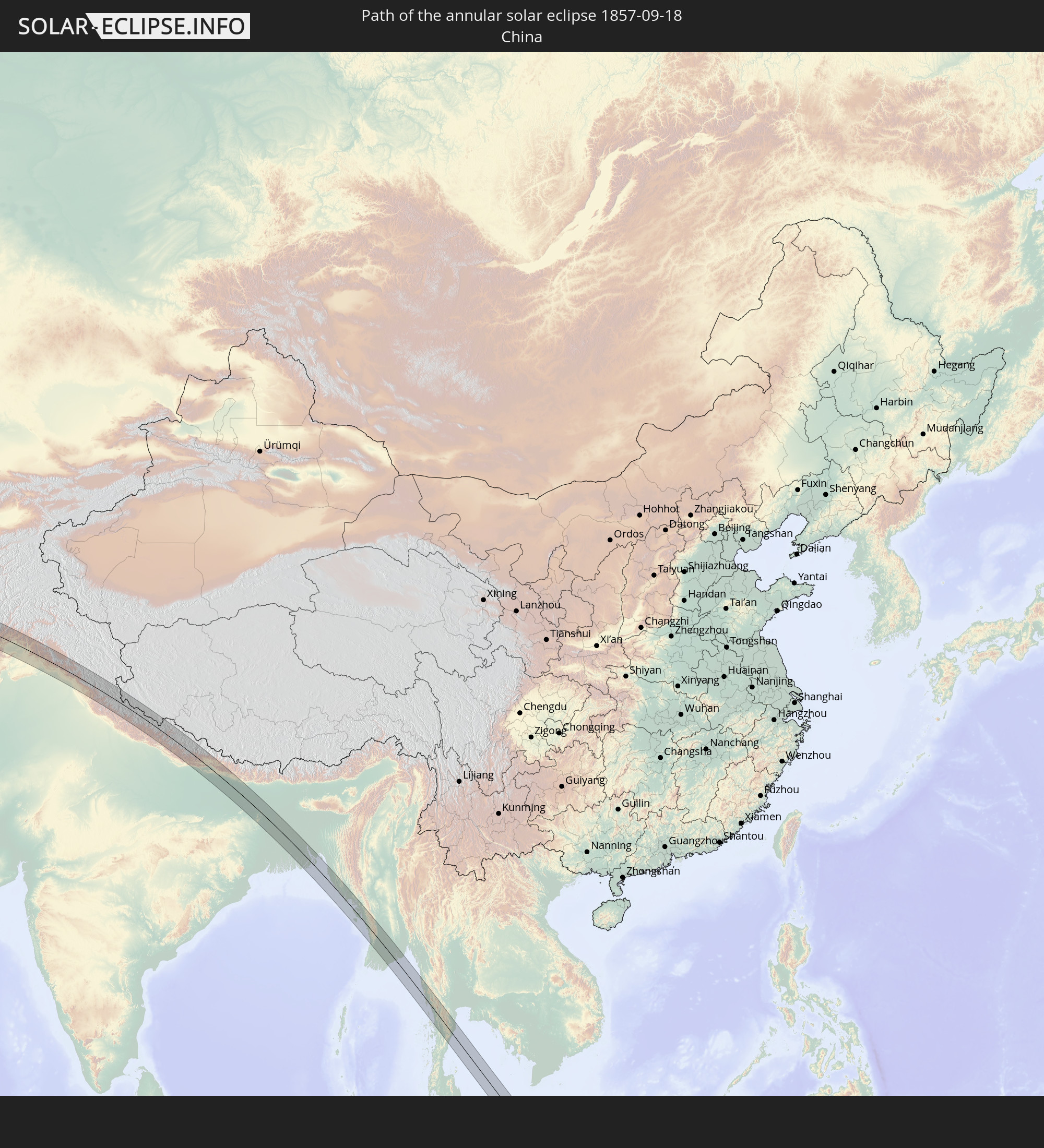
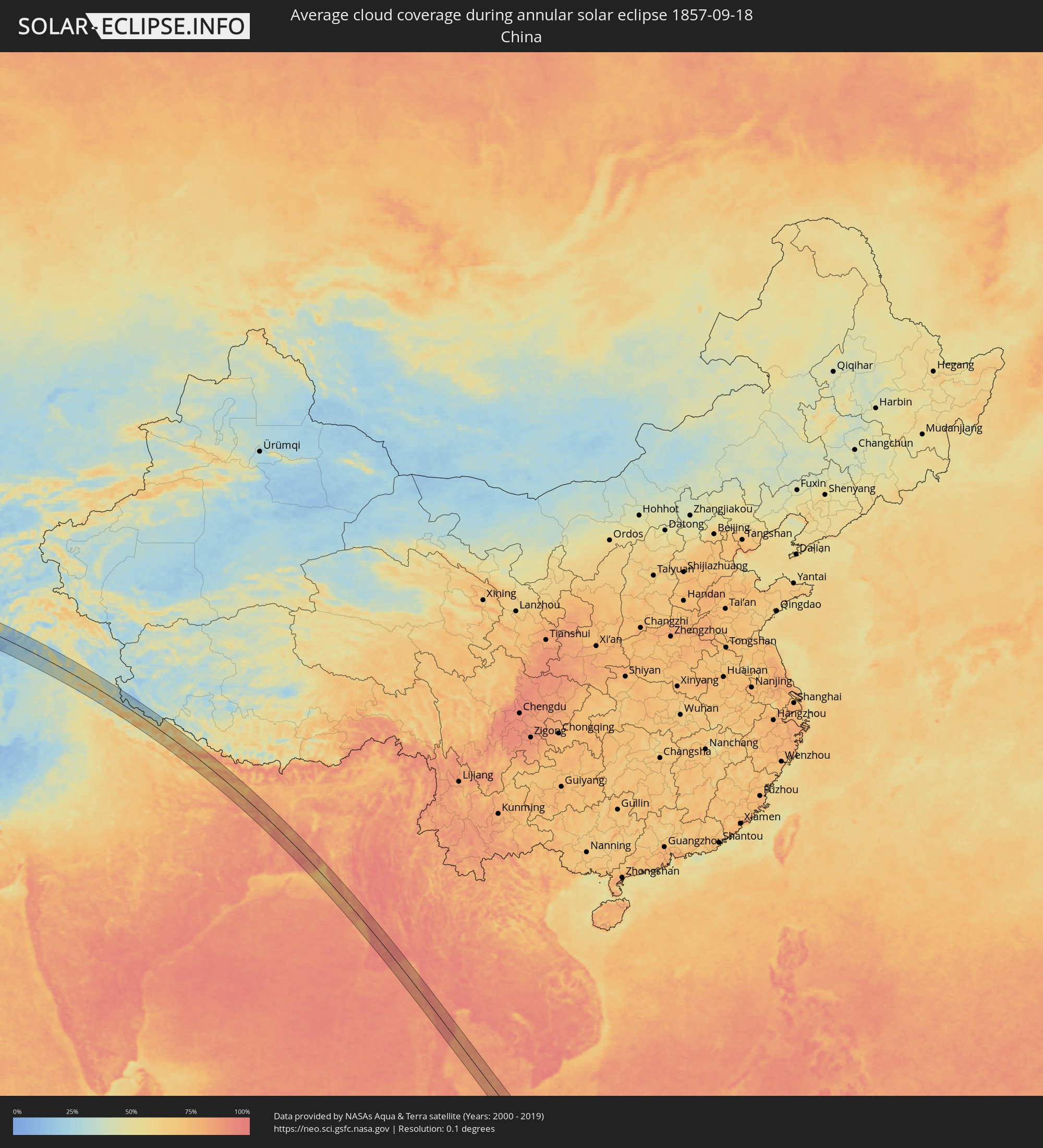 China
China
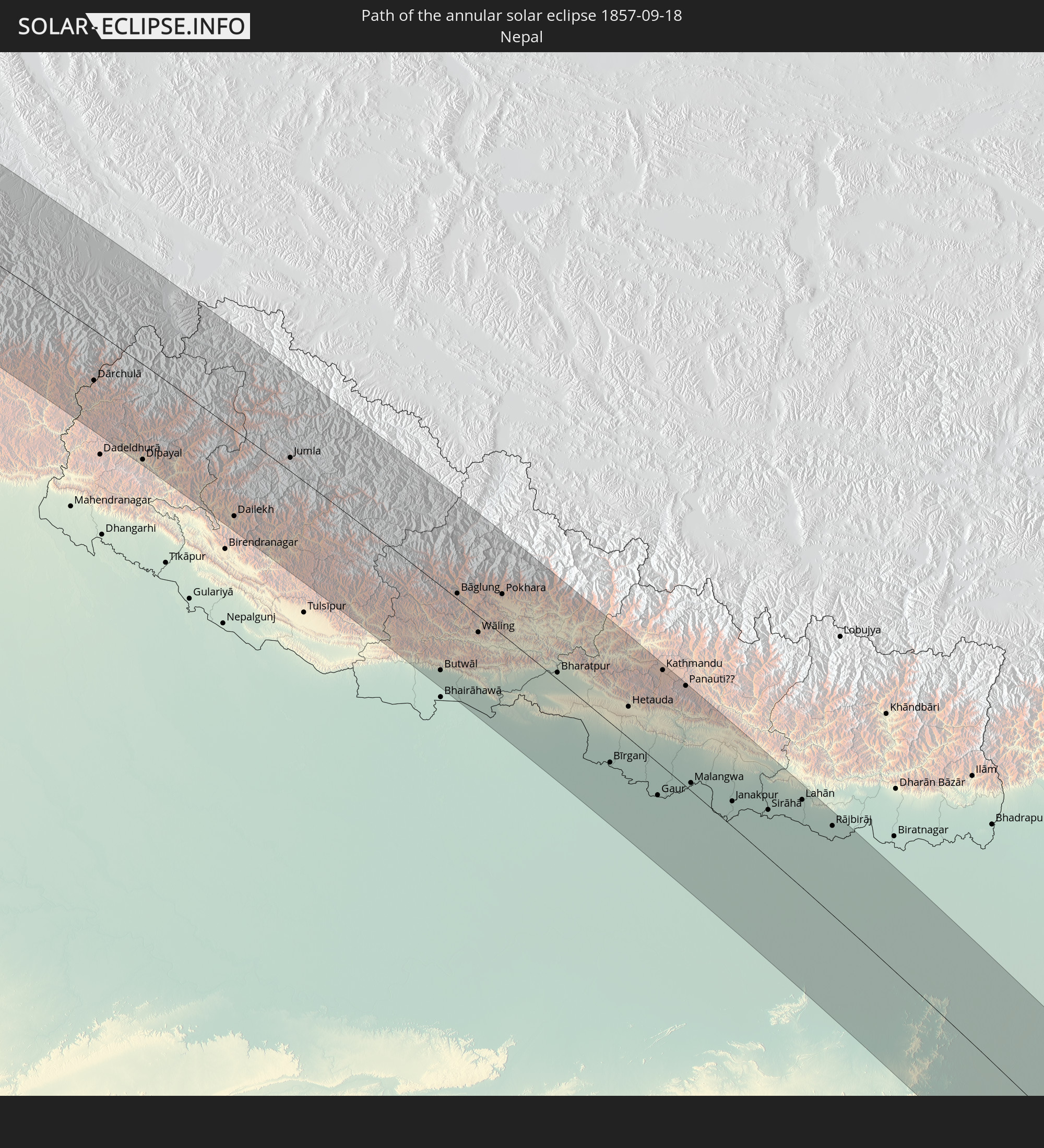
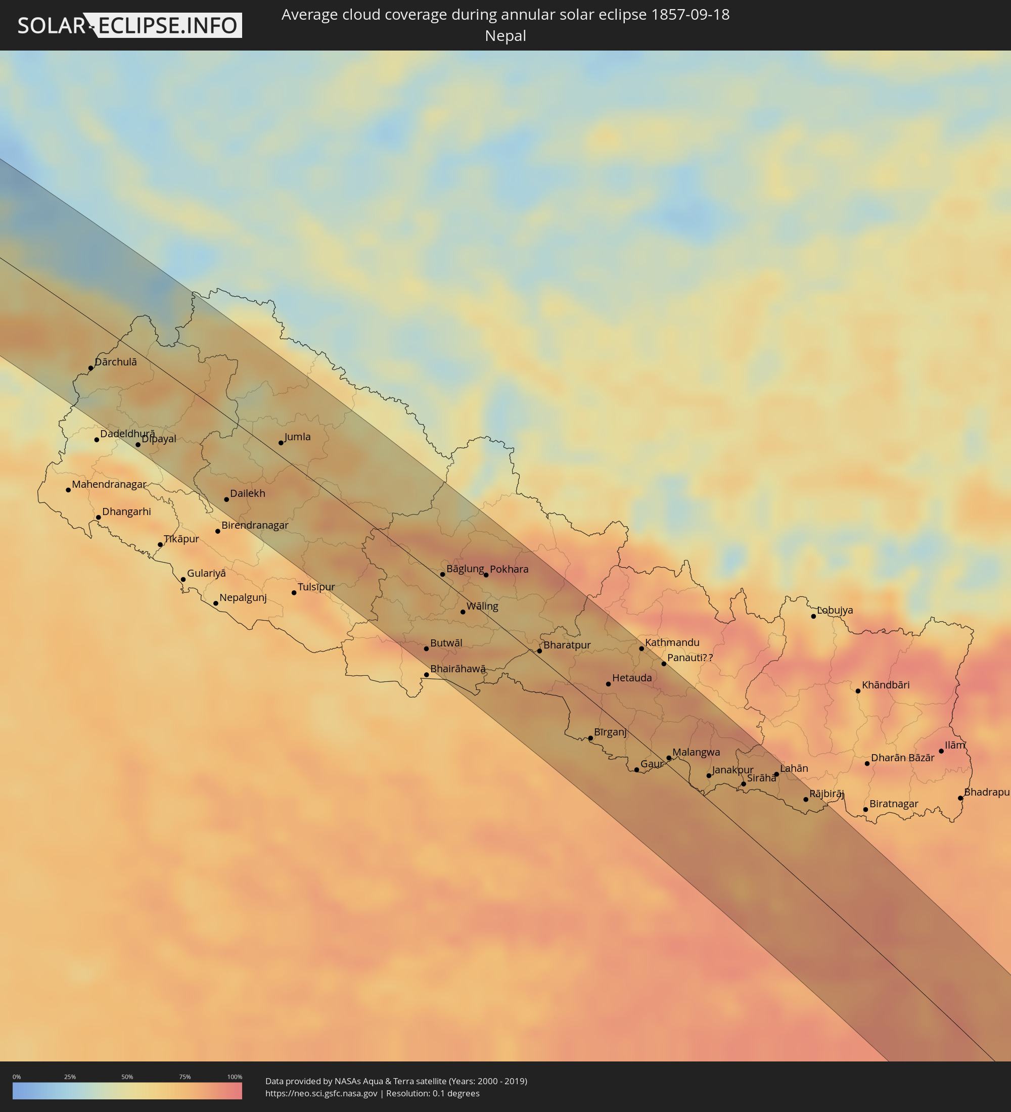 Nepal
Nepal
 Bangladesh
 Myanmar
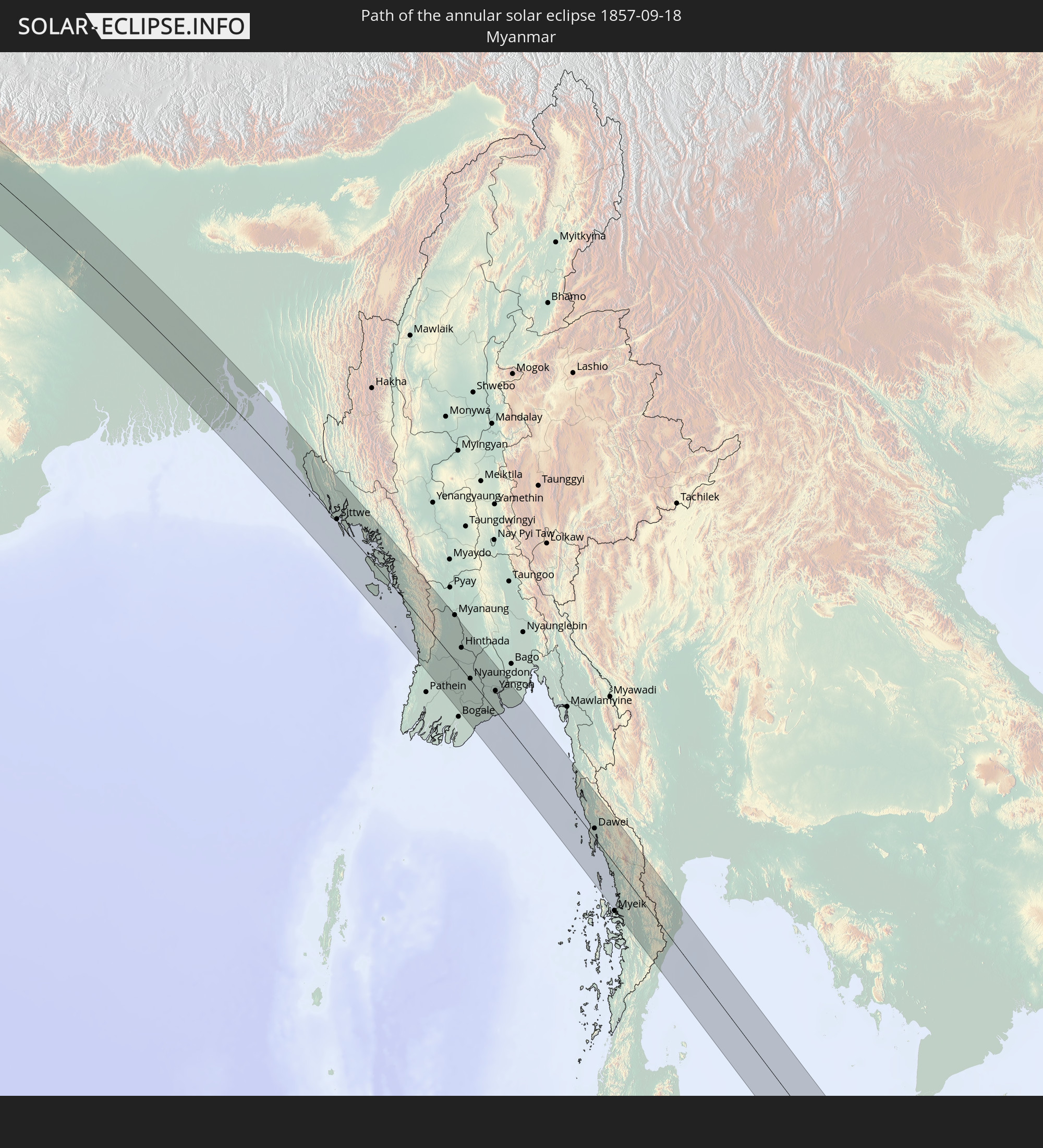
 Indonesia
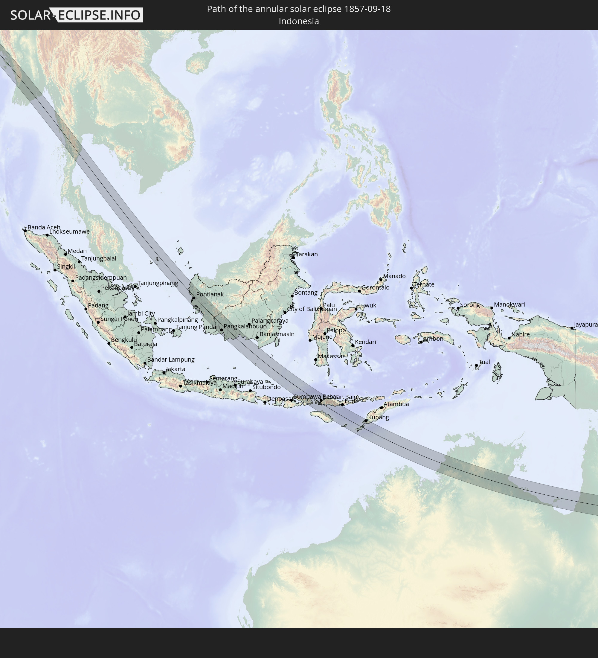
 Thailand
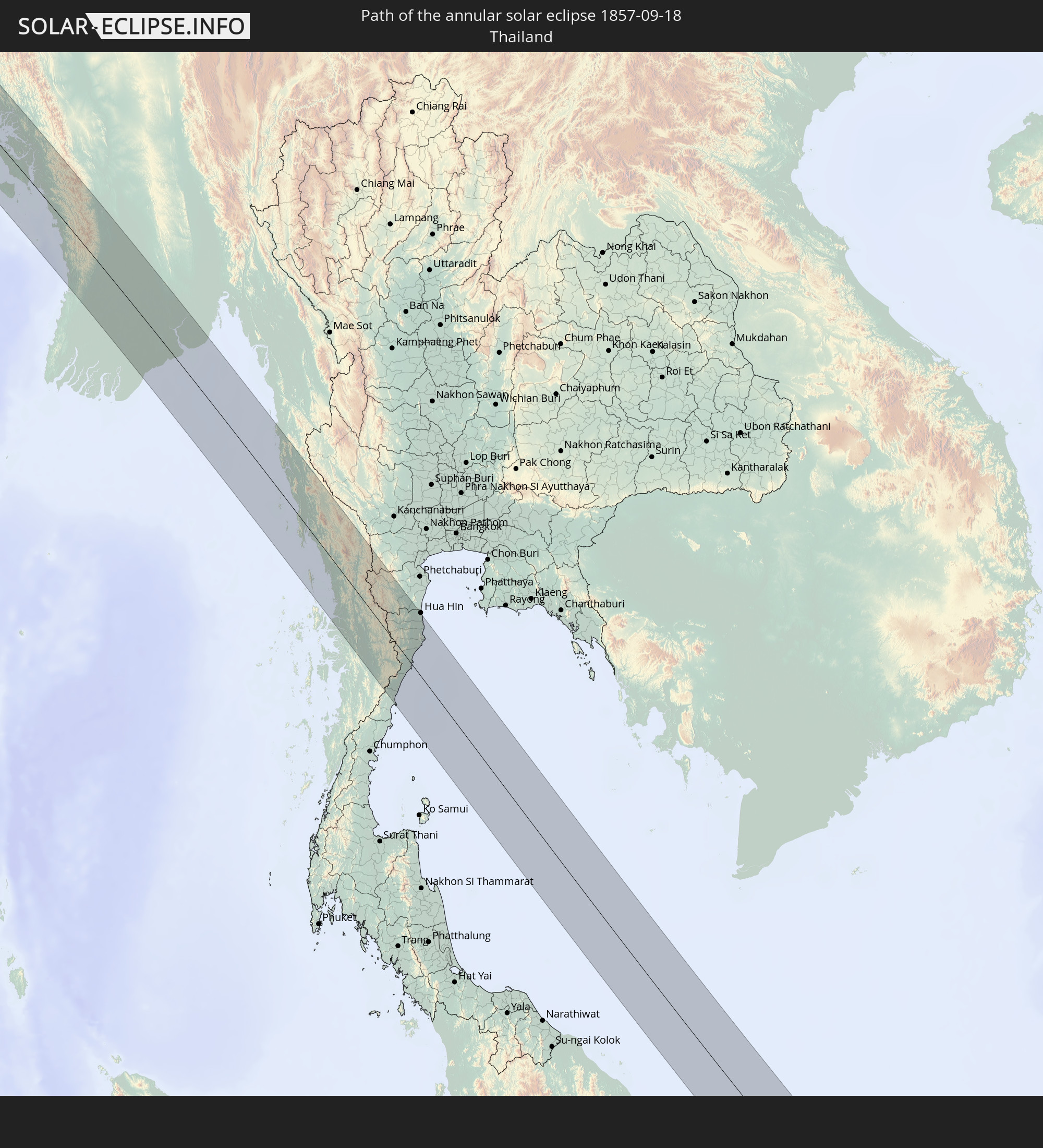
 Australia
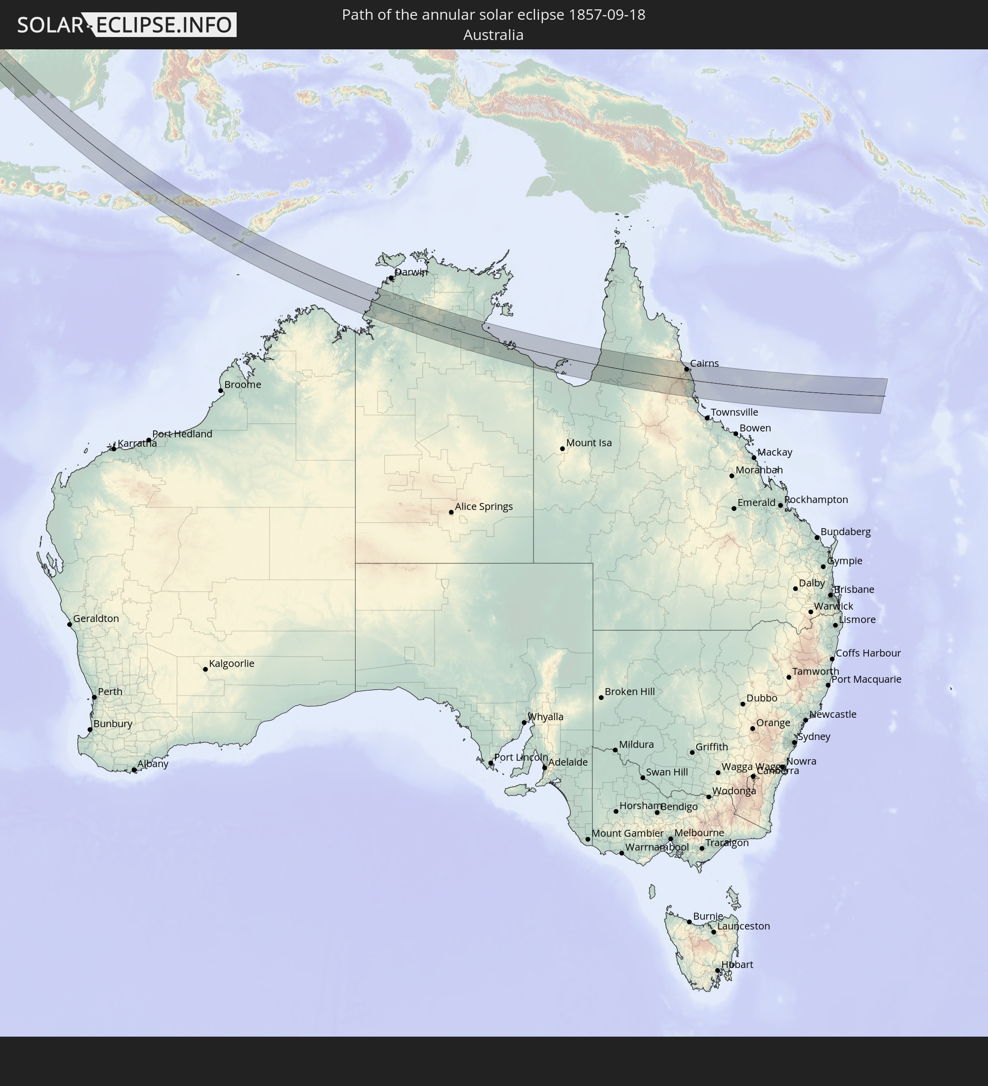
Cities inside the path of the eclipse
The following table shows all locations with a population of more than 5,000 inside the eclipse path. Cities which have more than 100,000 inhabitants are marked bold. A click at the locations opens a detailed map.
| City | Type | Eclipse duration | Local time of max. eclipse | Distance to central line | Ø Cloud coverage |
|
Bolu, Bolu
|
annular | - | 05:40:36 UTC+01:56 | 46 km | 35% |
|
Polatlı, Ankara
|
annular | - | 05:40:07 UTC+01:56 | 84 km | 23% |
|
Ankara, Ankara
|
annular | - | 05:40:16 UTC+01:56 | 48 km | 29% |
|
Kırıkkale, Kırıkkale
|
annular | - | 05:40:16 UTC+01:56 | 58 km | 23% |
|
Çorum, Çorum
|
annular | - | 05:40:39 UTC+01:56 | 18 km | 34% |
|
Turhal, Tokat
|
annular | - | 05:40:41 UTC+01:56 | 0 km | 30% |
|
Tokat, Tokat
|
annular | - | 05:40:43 UTC+01:56 | 8 km | 32% |
|
Sivas, Sivas
|
annular | - | 05:40:33 UTC+01:56 | 71 km | 24% |
|
Ordu, Ordu
|
annular | - | 05:41:10 UTC+01:56 | 67 km | 49% |
|
Giresun, Giresun
|
annular | - | 05:41:13 UTC+01:56 | 61 km | 59% |
|
Erzincan, Erzincan
|
annular | - | 05:40:58 UTC+01:56 | 68 km | 21% |
|
Trabzon, Trabzon
|
annular | - | 05:41:29 UTC+01:56 | 74 km | 62% |
|
Rize, Rize
|
annular | - | 05:41:40 UTC+01:56 | 78 km | 66% |
|
Erzurum, Erzurum
|
annular | - | 05:41:26 UTC+01:56 | 42 km | 31% |
|
Gyumri, Shirak Province
|
annular | - | 06:43:31 UTC+02:58 | 70 km | 22% |
|
Armavir, Armavir Province
|
annular | - | 06:43:22 UTC+02:58 | 0 km | 18% |
|
Ejmiatsin, Armavir Province
|
annular | - | 06:43:27 UTC+02:58 | 3 km | 17% |
|
Ashtarak, Aragatsotn Province
|
annular | - | 06:43:31 UTC+02:58 | 18 km | 18% |
|
Masis, Ararat Province
|
annular | - | 06:43:27 UTC+02:58 | 7 km | 16% |
|
Vanadzor, Lori Province
|
annular | - | 06:43:43 UTC+02:58 | 75 km | 55% |
|
Yerevan, Yerevan
|
annular | - | 06:43:32 UTC+02:58 | 6 km | 16% |
|
Artashat, Ararat Province
|
annular | - | 06:43:28 UTC+02:58 | 18 km | 18% |
|
Ararat, Ararat Province
|
annular | - | 06:43:29 UTC+02:58 | 31 km | 16% |
|
Hrazdan, Kotayk Province
|
annular | - | 06:43:43 UTC+02:58 | 43 km | 32% |
|
Sevan, Gegharkunik Province
|
annular | - | 06:43:47 UTC+02:58 | 50 km | 37% |
|
Gavarr, Gegharkunik Province
|
annular | - | 06:43:47 UTC+02:58 | 30 km | 42% |
|
Hats’avan, Syunik Province
|
annular | - | 06:43:50 UTC+02:58 | 62 km | 37% |
|
Goris, Syunik Province
|
annular | - | 06:43:59 UTC+02:58 | 53 km | 52% |
|
Ganja, Gǝncǝ
|
annular | - | 07:05:44 UTC+03:19 | 76 km | 55% |
|
Xankandi, Xankǝndi
|
annular | - | 07:05:38 UTC+03:19 | 16 km | 63% |
|
Ağdam, Ağdam
|
annular | - | 07:05:45 UTC+03:19 | 5 km | 56% |
|
Barda, Bǝrdǝ
|
annular | - | 07:05:57 UTC+03:19 | 49 km | 51% |
|
Fizuli, Füzuli
|
annular | - | 07:05:44 UTC+03:19 | 36 km | 50% |
|
Yevlakh, Yevlax City
|
annular | - | 07:06:01 UTC+03:19 | 76 km | 50% |
|
Agdzhabedy, Ağcabǝdi
|
annular | - | 07:05:59 UTC+03:19 | 16 km | 52% |
|
Pārsābād, Ardabīl
|
annular | - | 07:12:25 UTC+03:25 | 23 km | 54% |
|
Imishli, İmişli
|
annular | - | 07:06:12 UTC+03:19 | 3 km | 56% |
|
Saatlı, Saatlı
|
annular | - | 07:06:21 UTC+03:19 | 13 km | 55% |
|
Dzhalilabad, Jalilabad
|
annular | - | 07:06:14 UTC+03:19 | 66 km | 58% |
|
Şirvan, Shirvan
|
annular | - | 07:06:36 UTC+03:19 | 19 km | 60% |
|
Salyan, Salyan
|
annular | - | 07:06:33 UTC+03:19 | 18 km | 60% |
|
Baku, Baki
|
annular | - | 07:07:10 UTC+03:19 | 79 km | 46% |
|
Hövsan, Baki
|
annular | - | 07:07:15 UTC+03:19 | 81 km | 42% |
|
Balkanabat, Balkan
|
annular | - | 07:43:35 UTC+03:53 | 48 km | 16% |
|
Gumdag, Balkan
|
annular | - | 07:43:41 UTC+03:53 | 19 km | 14% |
|
Gazanjyk, Balkan
|
annular | - | 07:44:17 UTC+03:53 | 39 km | 15% |
|
Serdar, Balkan
|
annular | - | 07:44:46 UTC+03:53 | 24 km | 19% |
|
Baharly, Ahal
|
annular | - | 07:45:33 UTC+03:53 | 12 km | 16% |
|
Abadan, Ahal
|
annular | - | 07:46:07 UTC+03:53 | 38 km | 17% |
|
Ashgabat, Ahal
|
annular | - | 07:46:16 UTC+03:53 | 45 km | 19% |
|
Annau, Ahal
|
annular | - | 07:46:22 UTC+03:53 | 49 km | 18% |
|
Tejen, Ahal
|
annular | - | 07:48:00 UTC+03:53 | 57 km | 10% |
|
Mary, Mary
|
annular | - | 07:49:07 UTC+03:53 | 2 km | 11% |
|
Murgab
|
annular | - | 07:49:15 UTC+03:53 | 9 km | 11% |
|
Bayramaly, Mary
|
annular | - | 07:49:25 UTC+03:53 | 9 km | 12% |
|
Yolöten, Mary
|
annular | - | 07:49:38 UTC+03:53 | 20 km | 9% |
|
Andkhōy, Faryab
|
annular | - | 07:58:46 UTC+04:00 | 21 km | 9% |
|
Shibirghān, Jowzjan
|
annular | - | 07:59:28 UTC+04:00 | 11 km | 7% |
|
Sar-e Pul, Sar-e Pol
|
annular | - | 07:59:47 UTC+04:00 | 31 km | 6% |
|
Balkh, Balkh
|
annular | - | 08:00:37 UTC+04:00 | 56 km | 10% |
|
Mazār-e Sharīf, Balkh
|
annular | - | 08:00:51 UTC+04:00 | 58 km | 7% |
|
Aībak, Samangan
|
annular | - | 08:01:58 UTC+04:00 | 42 km | 8% |
|
Baghlān, Baghlan
|
annular | - | 08:02:47 UTC+04:00 | 51 km | 12% |
|
Pul-e Khumrī, Baghlan
|
annular | - | 08:02:52 UTC+04:00 | 33 km | 8% |
|
Nahrīn, Baghlan
|
annular | - | 08:03:17 UTC+04:00 | 60 km | 11% |
|
Charikar, Parwan
|
annular | - | 08:03:47 UTC+04:00 | 47 km | 11% |
|
Bāzārak, Panjshir
|
annular | - | 08:04:03 UTC+04:00 | 4 km | 13% |
|
Mehtar Lām, Laghman
|
annular | - | 08:05:10 UTC+04:00 | 43 km | 8% |
|
Jalālābād, Nangarhar
|
annular | - | 08:05:36 UTC+04:00 | 59 km | 10% |
|
Asadābād, Kunar
|
annular | - | 08:06:11 UTC+04:00 | 13 km | 17% |
|
Shabqadar, Khyber Pakhtunkhwa
|
annular | - | 08:35:16 UTC+04:28 | 37 km | 21% |
|
Peshawar, Khyber Pakhtunkhwa
|
annular | - | 08:35:25 UTC+04:28 | 57 km | 21% |
|
Chārsadda, Khyber Pakhtunkhwa
|
annular | - | 08:35:32 UTC+04:28 | 37 km | 23% |
|
Nowshera Cantonment, Khyber Pakhtunkhwa
|
annular | - | 08:35:57 UTC+04:28 | 42 km | 24% |
|
Mardan, Khyber Pakhtunkhwa
|
annular | - | 08:35:54 UTC+04:28 | 19 km | 25% |
|
Mingora, Khyber Pakhtunkhwa
|
annular | - | 08:35:56 UTC+04:28 | 51 km | 22% |
|
Attock City, Punjab
|
annular | - | 08:36:34 UTC+04:28 | 49 km | 27% |
|
Swābi, Khyber Pakhtunkhwa
|
annular | - | 08:36:28 UTC+04:28 | 10 km | 24% |
|
Rawalpindi, Punjab
|
annular | - | 08:37:35 UTC+04:28 | 37 km | 30% |
|
Abbottābād, Khyber Pakhtunkhwa
|
annular | - | 08:37:24 UTC+04:28 | 23 km | 27% |
|
Gūjar Khān, Punjab
|
annular | - | 08:38:08 UTC+04:28 | 61 km | 30% |
|
Muzaffarābād, Azad Kashmir
|
annular | - | 08:37:35 UTC+04:28 | 56 km | 22% |
|
Kotli, Azad Kashmir
|
annular | - | 08:38:44 UTC+04:28 | 10 km | 26% |
|
Bhimbar, Azad Kashmir
|
annular | - | 08:39:22 UTC+04:28 | 56 km | 36% |
|
Jammu, Kashmir
|
annular | - | 09:33:35 UTC+05:21 | 44 km | 38% |
|
Udhampur, Kashmir
|
annular | - | 09:33:48 UTC+05:21 | 13 km | 37% |
|
Pathānkot, Punjab
|
annular | - | 09:35:03 UTC+05:21 | 53 km | 46% |
|
Burang, Tibet Autonomous Region
|
annular | - | 12:24:06 UTC+08:00 | 44 km | 33% |
|
Butwāl, Western Region
|
annular | - | 10:12:27 UTC+05:41 | 55 km | 69% |
|
Tānsen, Western Region
|
annular | - | 10:12:23 UTC+05:41 | 34 km | 76% |
|
Pokhara, Western Region
|
annular | - | 10:12:31 UTC+05:41 | 26 km | 68% |
|
Bharatpur, Central Region
|
annular | - | 10:14:08 UTC+05:41 | 4 km | 66% |
|
Bīrganj, Central Region
|
annular | - | 10:15:54 UTC+05:41 | 25 km | 72% |
|
Mothīhāri, Bihar
|
annular | - | 09:56:25 UTC+05:21 | 54 km | 78% |
|
Hetauda, Central Region
|
annular | - | 10:15:32 UTC+05:41 | 20 km | 83% |
|
Gaur, Central Region
|
annular | - | 10:16:58 UTC+05:41 | 21 km | 78% |
|
Kathmandu, Central Region
|
annular | - | 10:15:37 UTC+05:41 | 62 km | 74% |
|
Panauti̇̄, Central Region
|
annular | - | 10:16:07 UTC+05:41 | 64 km | 83% |
|
Jaleswar, Central Region
|
annular | - | 10:18:03 UTC+05:41 | 3 km | 80% |
|
Darbhanga, Bihar
|
annular | - | 09:58:55 UTC+05:21 | 32 km | 84% |
|
Janakpur, Central Region
|
annular | - | 10:18:08 UTC+05:41 | 16 km | 74% |
|
Sirāhā, Eastern Region
|
annular | - | 10:18:45 UTC+05:41 | 30 km | 76% |
|
Monghyr, Bihar
|
annular | - | 10:01:13 UTC+05:21 | 59 km | 85% |
|
Lahān, Eastern Region
|
annular | - | 10:19:08 UTC+05:41 | 55 km | 76% |
|
Saharsa, Bihar
|
annular | - | 10:00:36 UTC+05:21 | 9 km | 82% |
|
Rājbirāj, Eastern Region
|
annular | - | 10:19:53 UTC+05:41 | 56 km | 72% |
|
Bhāgalpur, Bihar
|
annular | - | 10:02:19 UTC+05:21 | 36 km | 83% |
|
Purnia, Bihar
|
annular | - | 10:02:18 UTC+05:21 | 42 km | 89% |
|
Katihar, Bihar
|
annular | - | 10:02:53 UTC+05:21 | 29 km | 83% |
|
Sāhibganj, Jharkhand
|
annular | - | 10:03:30 UTC+05:21 | 9 km | 89% |
|
Jangipur, West Bengal
|
annular | - | 10:05:39 UTC+05:21 | 23 km | 84% |
|
Ingrāj Bāzār, West Bengal
|
annular | - | 10:04:50 UTC+05:21 | 25 km | 87% |
|
Baharampur, West Bengal
|
annular | - | 10:06:38 UTC+05:21 | 40 km | 86% |
|
Nawābganj, Rājshāhi
|
annular | - | 10:37:58 UTC+05:53 | 1 km | 83% |
|
Rājshāhi, Rājshāhi
|
annular | - | 10:38:56 UTC+05:53 | 6 km | 89% |
|
Ishurdi, Rājshāhi
|
annular | - | 10:40:14 UTC+05:53 | 20 km | 89% |
|
Kushtia, Khulna
|
annular | - | 10:40:45 UTC+05:53 | 5 km | 86% |
|
Jessore, Khulna
|
annular | - | 10:42:17 UTC+05:53 | 46 km | 90% |
|
Pābna, Rājshāhi
|
annular | - | 10:40:46 UTC+05:53 | 22 km | 84% |
|
Khulna, Khulna
|
annular | - | 10:43:37 UTC+05:53 | 48 km | 91% |
|
Shāhzādpur, Rājshāhi
|
annular | - | 10:41:06 UTC+05:53 | 62 km | 84% |
|
Farīdpur, Dhaka
|
annular | - | 10:42:37 UTC+05:53 | 34 km | 88% |
|
Mādārīpur, Dhaka
|
annular | - | 10:44:07 UTC+05:53 | 27 km | 90% |
|
Pālang, Dhaka
|
annular | - | 10:44:17 UTC+05:53 | 41 km | 88% |
|
Barisāl, Barisāl
|
annular | - | 10:45:19 UTC+05:53 | 3 km | 91% |
|
Bhola, Barisāl
|
annular | - | 10:45:52 UTC+05:53 | 22 km | 88% |
|
Cox’s Bāzār, Chittagong
|
annular | - | 10:50:55 UTC+05:53 | 30 km | 77% |
|
Sittwe, Rakhine
|
annular | - | 11:26:46 UTC+06:24 | 3 km | 80% |
|
Hinthada, Ayeyarwady
|
annular | - | 11:37:14 UTC+06:24 | 29 km | 92% |
|
Nyaungdon, Ayeyarwady
|
annular | - | 11:39:00 UTC+06:24 | 2 km | 94% |
|
Maubin, Ayeyarwady
|
annular | - | 11:39:45 UTC+06:24 | 19 km | 94% |
|
Pyapon, Ayeyarwady
|
annular | - | 11:40:51 UTC+06:24 | 48 km | 94% |
|
Kyaiklat, Ayeyarwady
|
annular | - | 11:40:34 UTC+06:24 | 33 km | 95% |
|
Tharyarwady, Bago
|
annular | - | 11:37:52 UTC+06:24 | 57 km | 94% |
|
Twante, Yangon
|
annular | - | 11:40:20 UTC+06:24 | 2 km | 96% |
|
Kanbe, Yangon
|
annular | - | 11:40:29 UTC+06:24 | 8 km | 96% |
|
Yangon, Yangon
|
annular | - | 11:40:33 UTC+06:24 | 28 km | 95% |
|
Syriam, Yangon
|
annular | - | 11:40:49 UTC+06:24 | 33 km | 95% |
|
Thongwa, Yangon
|
annular | - | 11:41:22 UTC+06:24 | 56 km | 96% |
|
Dawei, Tanintharyi
|
annular | - | 11:51:02 UTC+06:24 | 13 km | 92% |
|
Prachuap Khiri Khan, Prachuap Khiri Khan
|
annular | - | 12:17:02 UTC+06:42 | 2 km | 91% |
|
Kui Buri, Prachuap Khiri Khan
|
annular | - | 12:16:31 UTC+06:42 | 22 km | 94% |
|
Sam Roi Yot, Prachuap Khiri Khan
|
annular | - | 12:16:04 UTC+06:42 | 36 km | 95% |
|
Pran Buri, Prachuap Khiri Khan
|
annular | - | 12:15:51 UTC+06:42 | 46 km | 95% |
|
Sungai Raya, West Kalimantan
|
annular | - | 13:26:57 UTC+07:07 | 10 km | 86% |
|
Pemangkat, West Kalimantan
|
annular | - | 13:25:58 UTC+07:07 | 50 km | 89% |
|
Singkawang, West Kalimantan
|
annular | - | 13:26:36 UTC+07:07 | 32 km | 92% |
|
Pontianak, West Kalimantan
|
annular | - | 13:29:24 UTC+07:07 | 11 km | 92% |
|
Manismata, West Kalimantan
|
annular | - | 13:37:50 UTC+07:07 | 66 km | 91% |
|
Pangkalanbuun, Central Kalimantan
|
annular | - | 13:39:18 UTC+07:07 | 37 km | 90% |
|
Dompu, West Nusa Tenggara
|
annular | - | 14:51:35 UTC+07:57 | 69 km | 56% |
|
Bima, West Nusa Tenggara
|
annular | - | 14:51:49 UTC+07:57 | 46 km | 46% |
|
Labuan Bajo, East Nusa Tenggara
|
annular | - | 14:53:28 UTC+07:57 | 20 km | 57% |
|
Waingapu, East Nusa Tenggara
|
annular | - | 14:55:51 UTC+07:57 | 67 km | 37% |
|
Ruteng, East Nusa Tenggara
|
annular | - | 14:54:26 UTC+07:57 | 44 km | 66% |
|
Kupang, East Nusa Tenggara
|
annular | - | 15:00:50 UTC+07:57 | 66 km | 32% |
|
Katherine, Northern Territory
|
annular | - | 16:47:10 UTC+09:30 | 4 km | 23% |
|
Mareeba, Queensland
|
annular | - | 17:26:28 UTC+10:00 | 39 km | 36% |
|
Atherton, Queensland
|
annular | - | 17:26:39 UTC+10:00 | 9 km | 42% |
|
Redlynch, Queensland
|
annular | - | 17:26:29 UTC+10:00 | 55 km | 45% |
|
Cairns, Queensland
|
annular | - | 17:26:32 UTC+10:00 | 52 km | 40% |
|
Innisfail, Queensland
|
annular | - | 17:26:57 UTC+10:00 | 11 km | 52% |