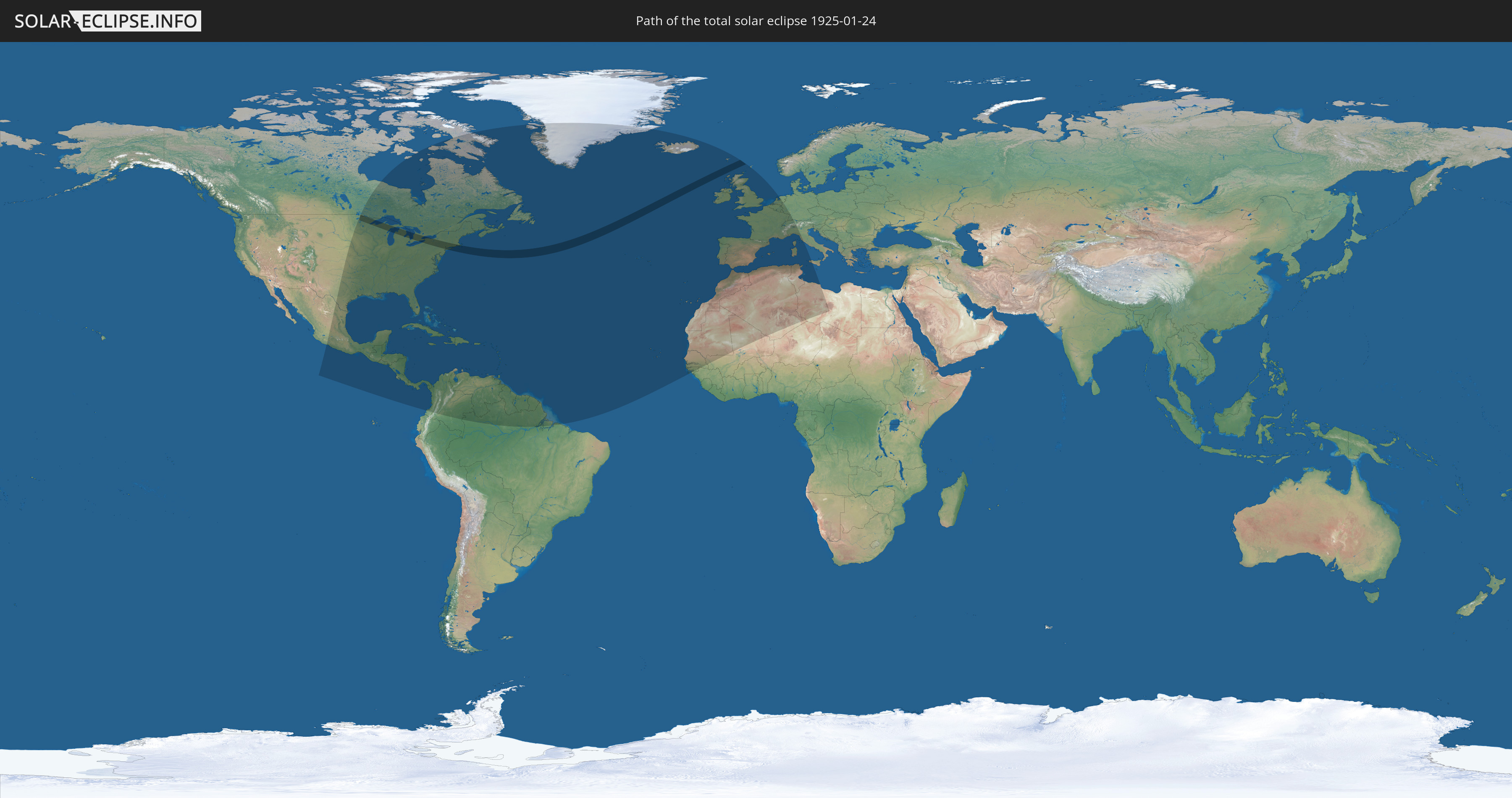
Total solar eclipse of 01/24/1925
| Day of week: | Saturday |
| Maximum duration of eclipse: | 02m32s |
| Maximum width of eclipse path: | 206 km |
| Saros cycle: | 120 |
| Coverage: | 100% |
| Magnitude: | 1.0304 |
| Gamma: | 0.8661 |
Wo kann man die Sonnenfinsternis vom 01/24/1925 sehen?
Die Sonnenfinsternis am 01/24/1925 kann man in 75 Ländern als partielle Sonnenfinsternis beobachten.
Der Finsternispfad verläuft durch 2 Länder. Nur in diesen Ländern ist sie als total Sonnenfinsternis zu sehen.
In den folgenden Ländern ist die Sonnenfinsternis total zu sehen
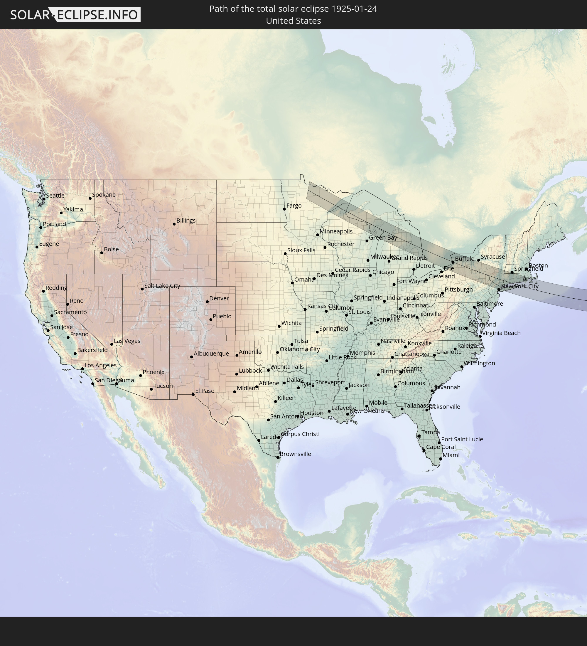 United States
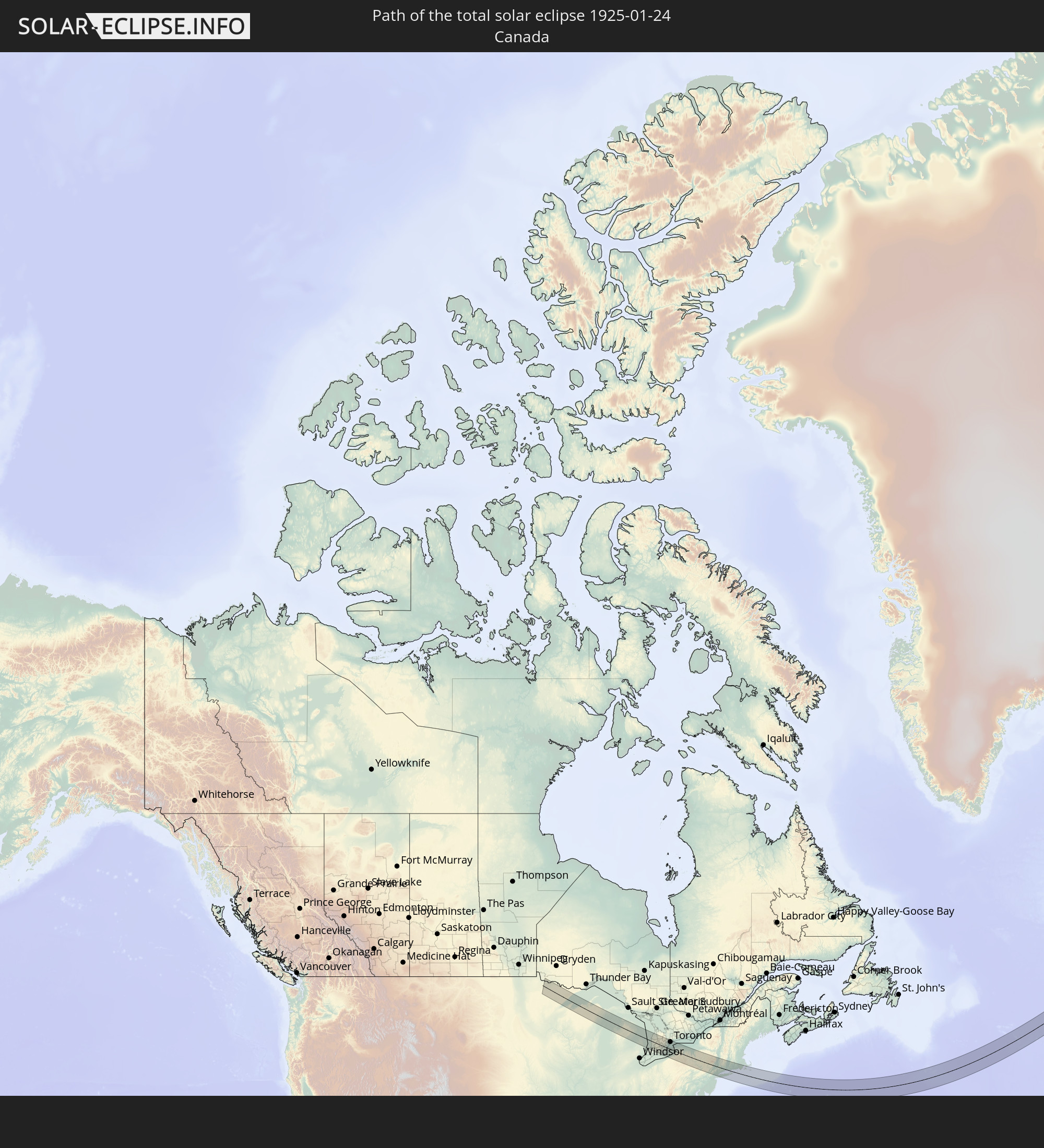 Canada
In den folgenden Ländern ist die Sonnenfinsternis partiell zu sehen
 United States
 United States Minor Outlying Islands
 Canada
 Mexico
 Greenland
 Guatemala
 El Salvador
 Honduras
 Belize
 Nicaragua
 Costa Rica
 Cuba
Cuba
 Panama
 Colombia
 Cayman Islands
 The Bahamas
 Jamaica
 Haiti
Haiti
 Brazil
 Venezuela
 Turks and Caicos Islands
 Dominican Republic
 Aruba
Aruba
 Puerto Rico
 United States Virgin Islands
 Bermuda
 British Virgin Islands
 Anguilla
 Collectivity of Saint Martin
 Saint Barthélemy
 Saint Kitts and Nevis
 Antigua and Barbuda
 Montserrat
 Trinidad and Tobago
 Guadeloupe
 Grenada
 Dominica
 Saint Vincent and the Grenadines
 Guyana
 Martinique
 Saint Lucia
 Barbados
 Suriname
 Saint Pierre and Miquelon
 French Guiana
 Portugal
 Cabo Verde
 Iceland
 Spain
Spain
 Senegal
 Mauritania
 The Gambia
 Guinea-Bissau
 Guinea
 Morocco
 Mali
Mali
 Republic of Ireland
 Algeria
 United Kingdom
 Faroe Islands
 Gibraltar
 France
 Isle of Man
 Guernsey
 Jersey
 Andorra
 Belgium
 Netherlands
 Luxembourg
 Germany
 Switzerland
 Italy
Italy
 Monaco
 Tunisia
 Libya
Libya
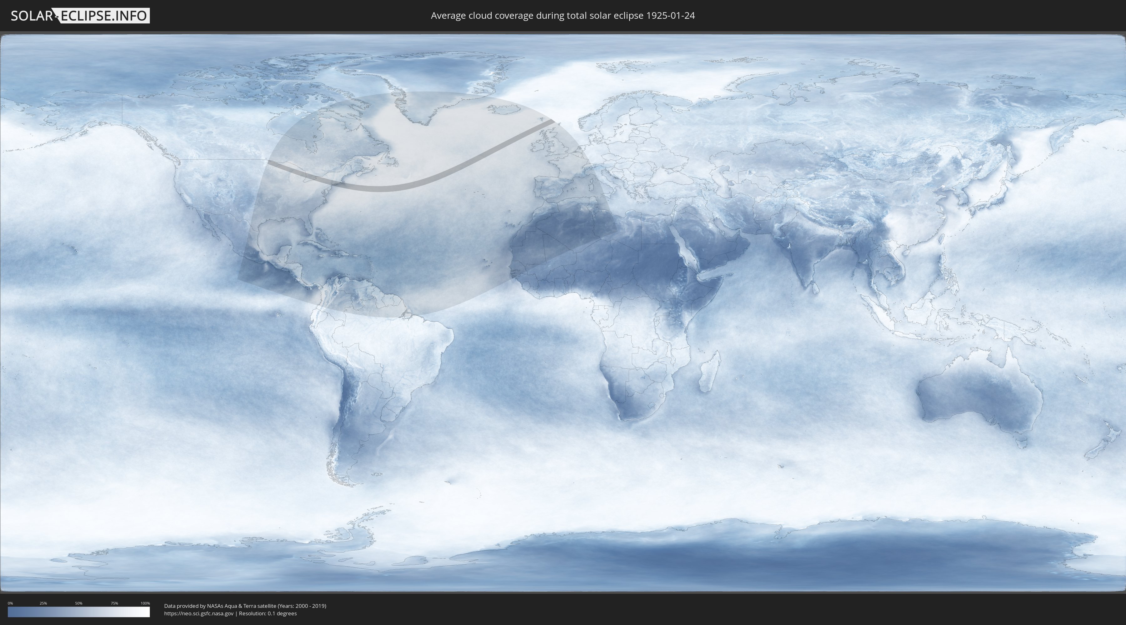
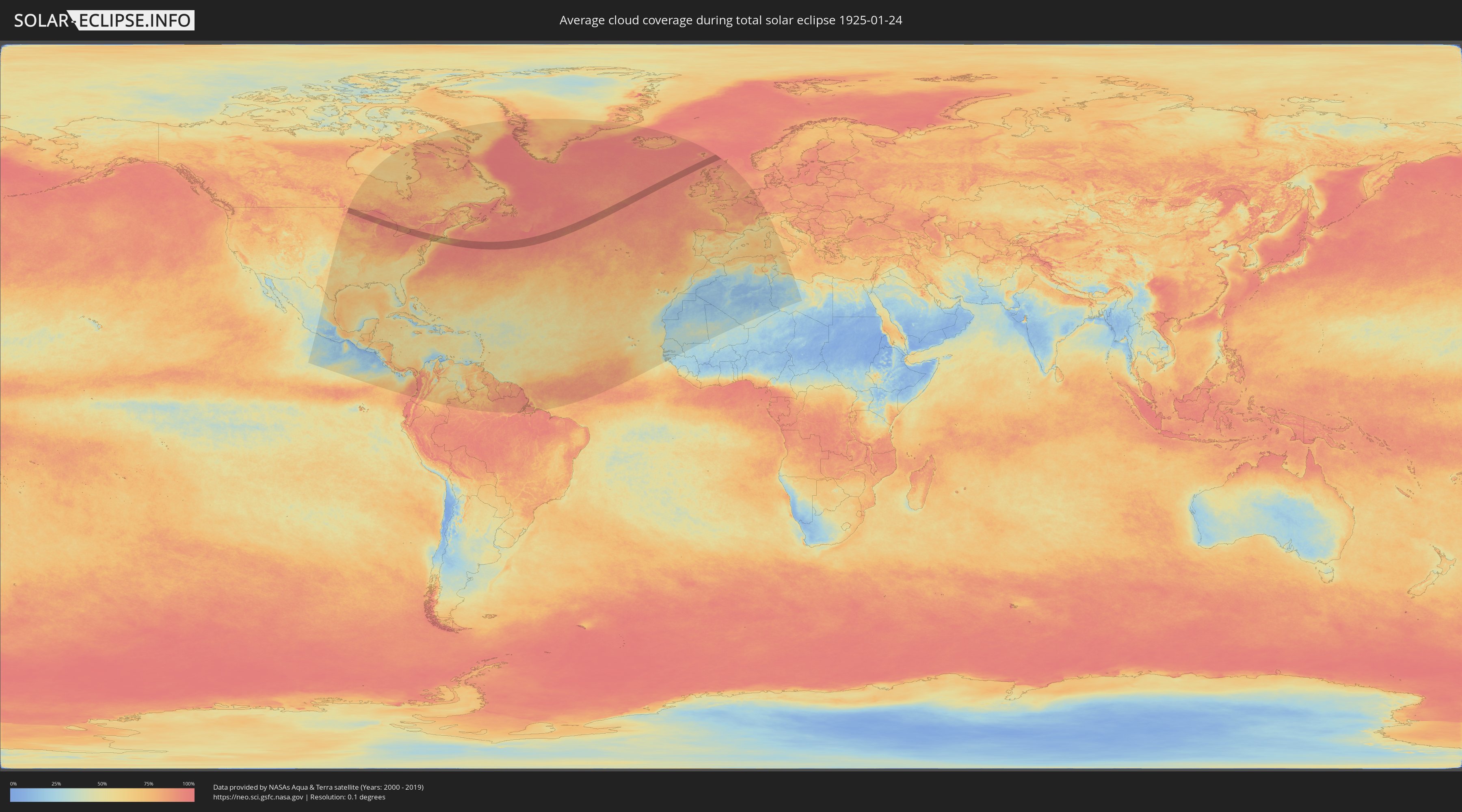
How will be the weather during the total solar eclipse on 01/24/1925?
Where is the best place to see the total solar eclipse of 01/24/1925?
The following maps show the average cloud coverage for the day of the total solar eclipse.
With the help of these maps, it is possible to find the place along the eclipse path, which has the best
chance of a cloudless sky.
Nevertheless, you should consider local circumstances and inform about the weather of your chosen
observation site.
The data is provided by NASAs satellites
AQUA and TERRA.
The cloud maps are averaged over a period of 19 years (2000 - 2019).
Detailed country maps
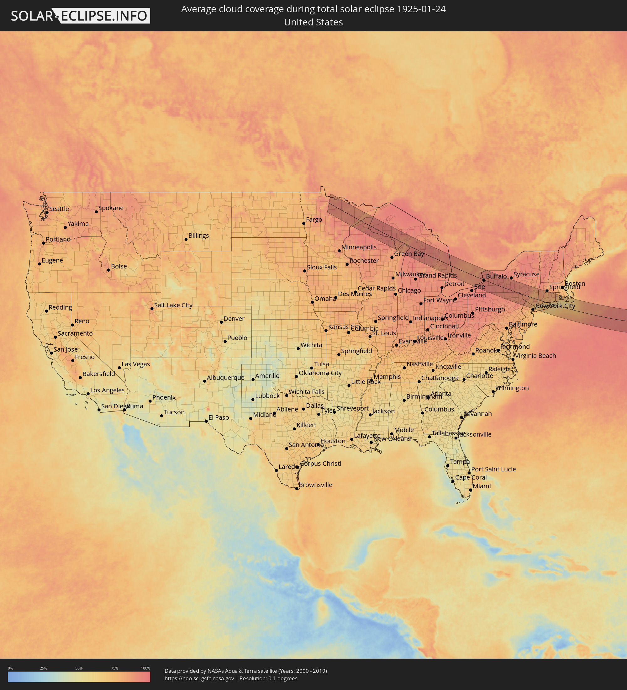 United States
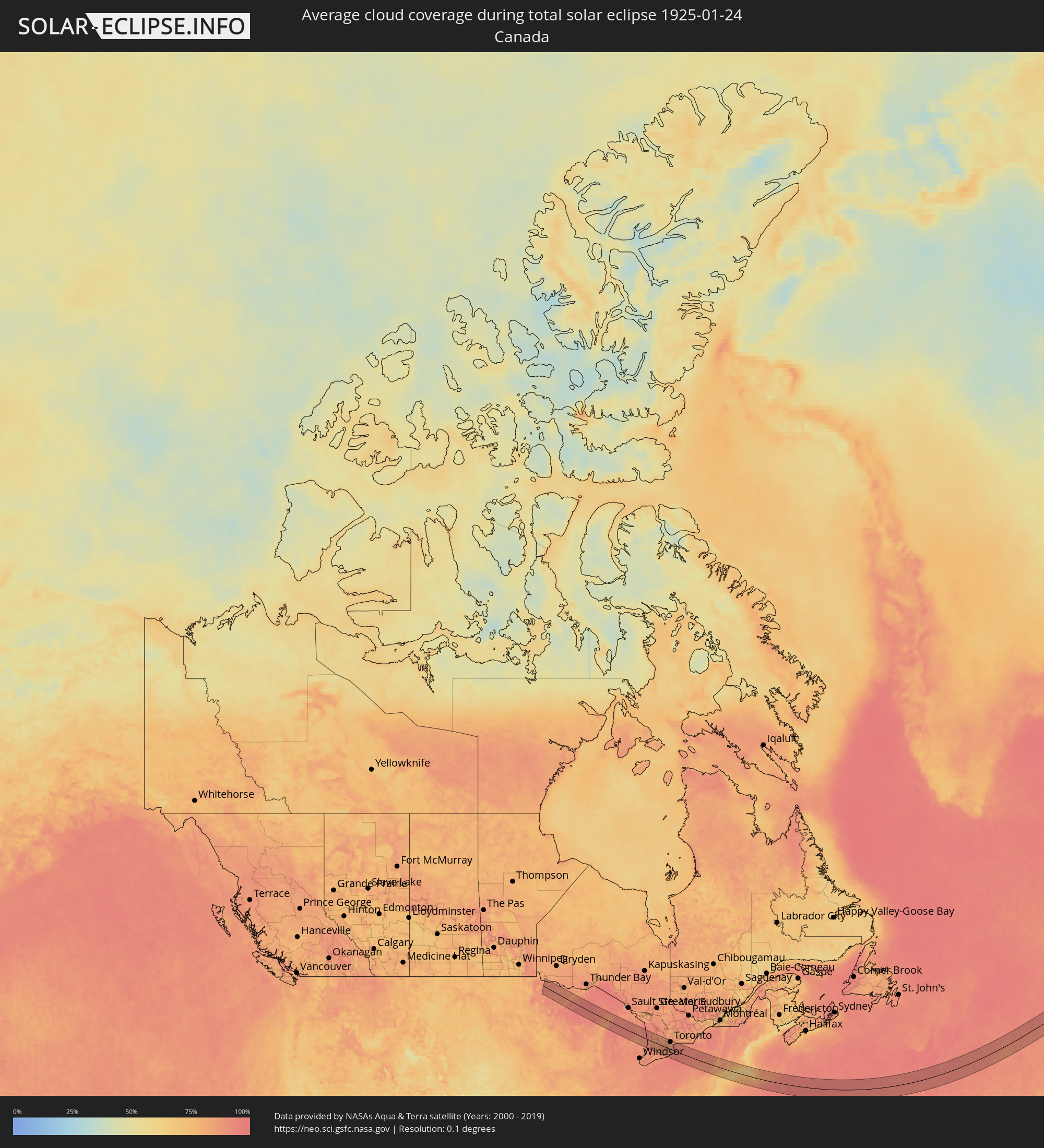 Canada
Cities inside the path of the eclipse
The following table shows all locations with a population of more than 5,000 inside the eclipse path. Cities which have more than 100,000 inhabitants are marked bold. A click at the locations opens a detailed map.
| City | Type | Eclipse duration | Local time of max. eclipse | Distance to central line | Ø Cloud coverage |
|
Fort Frances, Ontario
|
total | - | 08:03:09 UTC-06:00 | 66 km | 87% |
|
Hibbing, Minnesota
|
total | - | 08:01:41 UTC-06:00 | 31 km | 90% |
|
Virginia, Minnesota
|
total | - | 08:02:05 UTC-06:00 | 7 km | 91% |
|
Duluth, Minnesota
|
total | - | 08:01:16 UTC-06:00 | 64 km | 86% |
|
Ashland, Wisconsin
|
total | - | 08:01:48 UTC-06:00 | 38 km | 88% |
|
Iron Mountain, Michigan
|
total | - | 08:02:44 UTC-06:00 | 14 km | 94% |
|
Marinette, Wisconsin
|
total | - | 08:02:03 UTC-06:00 | 70 km | 85% |
|
Escanaba, Michigan
|
total | - | 09:03:25 UTC-05:00 | 14 km | 89% |
|
Traverse City, Michigan
|
total | - | 09:03:15 UTC-05:00 | 34 km | 93% |
|
Alpena, Michigan
|
total | - | 09:05:37 UTC-05:00 | 71 km | 92% |
|
Lambton Shores, Ontario
|
total | - | 09:04:30 UTC-05:00 | 72 km | 91% |
|
Goderich, Ontario
|
total | - | 09:05:30 UTC-05:00 | 6 km | 88% |
|
Kincardine, Ontario
|
total | - | 09:06:11 UTC-05:00 | 41 km | 90% |
|
Bluewater, Ontario
|
total | - | 09:05:15 UTC-05:00 | 31 km | 89% |
|
South Huron, Ontario
|
total | - | 09:05:08 UTC-05:00 | 43 km | 91% |
|
Huron East, Ontario
|
total | - | 09:05:45 UTC-05:00 | 6 km | 87% |
|
London, Ontario
|
total | - | 09:04:59 UTC-05:00 | 68 km | 89% |
|
Dorchester, Ontario
|
total | - | 09:05:09 UTC-05:00 | 63 km | 88% |
|
Hanover, Ontario
|
total | - | 09:06:45 UTC-05:00 | 57 km | 86% |
|
North Perth, Ontario
|
total | - | 09:06:14 UTC-05:00 | 16 km | 84% |
|
Stratford, Ontario
|
total | - | 09:05:47 UTC-05:00 | 20 km | 85% |
|
Ingersoll, Ontario
|
total | - | 09:05:25 UTC-05:00 | 52 km | 86% |
|
Woodstock, Ontario
|
total | - | 09:05:41 UTC-05:00 | 37 km | 86% |
|
Waterloo, Ontario
|
total | - | 09:06:22 UTC-05:00 | 4 km | 88% |
|
Kitchener, Ontario
|
total | - | 09:06:19 UTC-05:00 | 0 km | 87% |
|
Paris, Ontario
|
total | - | 09:06:09 UTC-05:00 | 19 km | 88% |
|
Norfolk County, Ontario
|
total | - | 09:05:40 UTC-05:00 | 57 km | 88% |
|
Brant, Ontario
|
total | - | 09:06:06 UTC-05:00 | 25 km | 89% |
|
Cambridge, Ontario
|
total | - | 09:06:27 UTC-05:00 | 0 km | 89% |
|
Brantford, Ontario
|
total | - | 09:06:12 UTC-05:00 | 22 km | 89% |
|
Guelph, Ontario
|
total | - | 09:06:45 UTC-05:00 | 21 km | 90% |
|
Orangeville, Ontario
|
total | - | 09:07:25 UTC-05:00 | 63 km | 83% |
|
Ancaster, Ontario
|
total | - | 09:06:36 UTC-05:00 | 5 km | 88% |
|
Milton, Ontario
|
total | - | 09:07:07 UTC-05:00 | 29 km | 89% |
|
Hamilton, Ontario
|
total | - | 09:06:48 UTC-05:00 | 3 km | 86% |
|
Burlington, Ontario
|
total | - | 09:06:59 UTC-05:00 | 17 km | 85% |
|
Brampton, Ontario
|
total | - | 09:07:28 UTC-05:00 | 50 km | 89% |
|
Oakville, Ontario
|
total | - | 09:07:14 UTC-05:00 | 29 km | 84% |
|
Mississauga, Ontario
|
total | - | 09:07:26 UTC-05:00 | 43 km | 87% |
|
Etobicoke, Ontario
|
total | - | 09:07:38 UTC-05:00 | 53 km | 87% |
|
Vaughan, Ontario
|
total | - | 09:07:57 UTC-05:00 | 74 km | 87% |
|
Concord, Ontario
|
total | - | 09:07:55 UTC-05:00 | 71 km | 87% |
|
North York, Ontario
|
total | - | 09:07:57 UTC-05:00 | 70 km | 85% |
|
Toronto, Ontario
|
total | - | 09:07:52 UTC-05:00 | 63 km | 85% |
|
Willowdale, Ontario
|
total | - | 09:07:58 UTC-05:00 | 70 km | 85% |
|
Dunkirk, New York
|
total | - | 09:06:21 UTC-05:00 | 60 km | 95% |
|
East York, Ontario
|
total | - | 09:07:57 UTC-05:00 | 65 km | 84% |
|
Scarborough, Ontario
|
total | - | 09:08:08 UTC-05:00 | 75 km | 85% |
|
Welland, Ontario
|
total | - | 09:07:06 UTC-05:00 | 6 km | 91% |
|
St. Catharines, Ontario
|
total | - | 09:07:22 UTC-05:00 | 14 km | 91% |
|
Port Colborne, Ontario
|
total | - | 09:07:01 UTC-05:00 | 14 km | 90% |
|
Thorold, Ontario
|
total | - | 09:07:20 UTC-05:00 | 10 km | 91% |
|
Niagara Falls, Ontario
|
total | - | 09:07:28 UTC-05:00 | 12 km | 92% |
|
Niagara Falls, New York
|
total | - | 09:07:28 UTC-05:00 | 12 km | 92% |
|
Fort Erie, Ontario
|
total | - | 09:07:21 UTC-05:00 | 5 km | 93% |
|
Buffalo, New York
|
total | - | 09:07:24 UTC-05:00 | 4 km | 93% |
|
North Tonawanda, New York
|
total | - | 09:07:36 UTC-05:00 | 12 km | 93% |
|
Hamburg, New York
|
total | - | 09:07:14 UTC-05:00 | 20 km | 94% |
|
Depew, New York
|
total | - | 09:07:38 UTC-05:00 | 3 km | 94% |
|
Lockport, New York
|
total | - | 09:07:59 UTC-05:00 | 31 km | 92% |
|
Olean, New York
|
total | - | 09:06:51 UTC-05:00 | 74 km | 95% |
|
Batavia, New York
|
total | - | 09:08:19 UTC-05:00 | 28 km | 94% |
|
Brockport, New York
|
total | - | 09:08:53 UTC-05:00 | 58 km | 93% |
|
Geneseo, New York
|
total | - | 09:08:30 UTC-05:00 | 18 km | 92% |
|
Hornell, New York
|
total | - | 09:08:04 UTC-05:00 | 25 km | 94% |
|
Rochester, New York
|
total | - | 09:09:11 UTC-05:00 | 62 km | 92% |
|
Canandaigua, New York
|
total | - | 09:09:13 UTC-05:00 | 42 km | 92% |
|
Newark, New York
|
total | - | 09:09:40 UTC-05:00 | 66 km | 93% |
|
Corning, New York
|
total | - | 09:08:34 UTC-05:00 | 27 km | 93% |
|
Geneva, New York
|
total | - | 09:09:35 UTC-05:00 | 51 km | 92% |
|
Elmira, New York
|
total | - | 09:08:47 UTC-05:00 | 25 km | 92% |
|
Auburn, New York
|
total | - | 09:10:09 UTC-05:00 | 69 km | 89% |
|
Ithaca, New York
|
total | - | 09:09:37 UTC-05:00 | 20 km | 94% |
|
Cortland, New York
|
total | - | 09:10:12 UTC-05:00 | 46 km | 93% |
|
Back Mountain, Pennsylvania
|
total | - | 09:08:51 UTC-05:00 | 81 km | 89% |
|
Binghamton, New York
|
total | - | 09:09:54 UTC-05:00 | 1 km | 92% |
|
Scranton, Pennsylvania
|
total | - | 09:09:21 UTC-05:00 | 64 km | 89% |
|
Norwich, New York
|
total | - | 09:10:56 UTC-05:00 | 57 km | 93% |
|
Carbondale, Pennsylvania
|
total | - | 09:09:46 UTC-05:00 | 42 km | 88% |
|
Oneonta, New York
|
total | - | 09:11:25 UTC-05:00 | 62 km | 91% |
|
Port Jervis, New York
|
total | - | 09:10:34 UTC-05:00 | 41 km | 87% |
|
Monticello, New York
|
total | - | 09:10:55 UTC-05:00 | 12 km | 89% |
|
Lake Mohawk, New Jersey
|
total | - | 09:10:10 UTC-05:00 | 78 km | 84% |
|
Middletown, New York
|
total | - | 09:11:00 UTC-05:00 | 27 km | 77% |
|
Boonton, New Jersey
|
total | - | 09:10:22 UTC-05:00 | 84 km | 78% |
|
West Milford, New Jersey
|
total | - | 09:10:42 UTC-05:00 | 58 km | 84% |
|
Walden, New York
|
total | - | 09:11:27 UTC-05:00 | 8 km | 80% |
|
Paterson, New Jersey
|
total | - | 09:10:42 UTC-05:00 | 76 km | 76% |
|
Kiryas Joel, New York
|
total | - | 09:11:13 UTC-05:00 | 31 km | 84% |
|
Ramsey, New Jersey
|
total | - | 09:10:54 UTC-05:00 | 60 km | 76% |
|
Manorville, New York
|
total | - | 09:12:22 UTC-05:00 | 57 km | 81% |
|
Newburgh, New York
|
total | - | 09:11:37 UTC-05:00 | 10 km | 81% |
|
Kingston, New York
|
total | - | 09:12:10 UTC-05:00 | 35 km | 80% |
|
New City, New York
|
total | - | 09:11:13 UTC-05:00 | 47 km | 75% |
|
Poughkeepsie, New York
|
total | - | 09:11:59 UTC-05:00 | 13 km | 80% |
|
Peekskill, New York
|
total | - | 09:11:29 UTC-05:00 | 30 km | 77% |
|
The Bronx, New York
|
total | - | 09:11:01 UTC-05:00 | 75 km | 76% |
|
Greenburgh, New York
|
total | - | 09:11:16 UTC-05:00 | 55 km | 71% |
|
Oakdale, New York
|
total | - | 09:12:51 UTC-05:00 | 75 km | 80% |
|
Mahopac, New York
|
total | - | 09:11:50 UTC-05:00 | 16 km | 82% |
|
Mount Kisco, New York
|
total | - | 09:11:38 UTC-05:00 | 34 km | 78% |
|
Glen Cove, New York
|
total | - | 09:11:21 UTC-05:00 | 68 km | 71% |
|
Hempstead, New York
|
total | - | 09:11:11 UTC-05:00 | 84 km | 73% |
|
Stamford, Connecticut
|
total | - | 09:11:43 UTC-05:00 | 45 km | 70% |
|
Danbury, Connecticut
|
total | - | 09:12:14 UTC-05:00 | 7 km | 83% |
|
Wilton, Connecticut
|
total | - | 09:12:01 UTC-05:00 | 28 km | 74% |
|
Huntington Station, New York
|
total | - | 09:11:39 UTC-05:00 | 63 km | 73% |
|
Lindenhurst, New York
|
total | - | 09:11:30 UTC-05:00 | 80 km | 74% |
|
Brentwood, New York
|
total | - | 09:11:47 UTC-05:00 | 67 km | 75% |
|
Southbury, Connecticut
|
total | - | 09:12:40 UTC-05:00 | 9 km | 81% |
|
Bridgeport, Connecticut
|
total | - | 09:12:18 UTC-05:00 | 25 km | 69% |
|
Torrington, Connecticut
|
total | - | 09:13:11 UTC-05:00 | 45 km | 86% |
|
Waterbury, Connecticut
|
total | - | 09:12:59 UTC-05:00 | 21 km | 82% |
|
Bayport, New York
|
total | - | 09:12:00 UTC-05:00 | 66 km | 73% |
|
Coram, New York
|
total | - | 09:12:13 UTC-05:00 | 51 km | 74% |
|
Bristol, Connecticut
|
total | - | 09:13:16 UTC-05:00 | 35 km | 80% |
|
New Haven, Connecticut
|
total | - | 09:12:51 UTC-05:00 | 3 km | 70% |
|
Wading River, New York
|
total | - | 09:12:33 UTC-05:00 | 39 km | 70% |
|
Mastic, New York
|
total | - | 09:12:22 UTC-05:00 | 54 km | 72% |
|
Meriden, Connecticut
|
total | - | 09:13:18 UTC-05:00 | 25 km | 77% |
|
Southwick, Massachusetts
|
total | - | 09:13:58 UTC-05:00 | 81 km | 82% |
|
Hartford, Connecticut
|
total | - | 09:13:44 UTC-05:00 | 52 km | 79% |
|
Guilford, Connecticut
|
total | - | 09:13:10 UTC-05:00 | 1 km | 69% |
|
Enfield, Connecticut
|
total | - | 09:14:07 UTC-05:00 | 77 km | 79% |
|
Hampton Bays, New York
|
total | - | 09:12:54 UTC-05:00 | 39 km | 71% |
|
East Haddam, Connecticut
|
total | - | 09:13:41 UTC-05:00 | 24 km | 77% |
|
Old Saybrook, Connecticut
|
total | - | 09:13:36 UTC-05:00 | 9 km | 66% |
|
Tolland, Connecticut
|
total | - | 09:14:18 UTC-05:00 | 71 km | 82% |
|
Hebron, Connecticut
|
total | - | 09:14:03 UTC-05:00 | 48 km | 83% |
|
Mansfield City, Connecticut
|
total | - | 09:14:22 UTC-05:00 | 63 km | 81% |
|
New London, Connecticut
|
total | - | 09:14:04 UTC-05:00 | 23 km | 71% |
|
Norwich, Connecticut
|
total | - | 09:14:18 UTC-05:00 | 41 km | 76% |
|
Plainfield, Connecticut
|
total | - | 09:14:43 UTC-05:00 | 61 km | 80% |
|
Killingly Center, Connecticut
|
total | - | 09:14:58 UTC-05:00 | 80 km | 81% |
|
Westerly, Rhode Island
|
total | - | 09:14:29 UTC-05:00 | 32 km | 72% |
|
Coventry, Rhode Island
|
total | - | 09:15:04 UTC-05:00 | 70 km | 82% |
|
Charlestown, Rhode Island
|
total | - | 09:14:45 UTC-05:00 | 37 km | 68% |
|
North Scituate, Rhode Island
|
total | - | 09:15:22 UTC-05:00 | 86 km | 80% |
|
North Kingstown, Rhode Island
|
total | - | 09:15:12 UTC-05:00 | 59 km | 76% |
|
Warwick, Rhode Island
|
total | - | 09:15:27 UTC-05:00 | 76 km | 73% |
|
Newport East, Rhode Island
|
total | - | 09:15:25 UTC-05:00 | 59 km | 64% |
|
Fall River, Massachusetts
|
total | - | 09:15:50 UTC-05:00 | 82 km | 74% |
|
New Bedford, Massachusetts
|
total | - | 09:16:04 UTC-05:00 | 80 km | 70% |
|
Nantucket, Massachusetts
|
total | - | 09:16:53 UTC-05:00 | 61 km | 68% |