Total solar eclipse of 01/16/2075
| Day of week: | Wednesday |
| Maximum duration of eclipse: | 02m42s |
| Maximum width of eclipse path: | 110 km |
| Saros cycle: | 142 |
| Coverage: | 100% |
| Magnitude: | 1.0311 |
| Gamma: | -0.2799 |
Wo kann man die Sonnenfinsternis vom 01/16/2075 sehen?
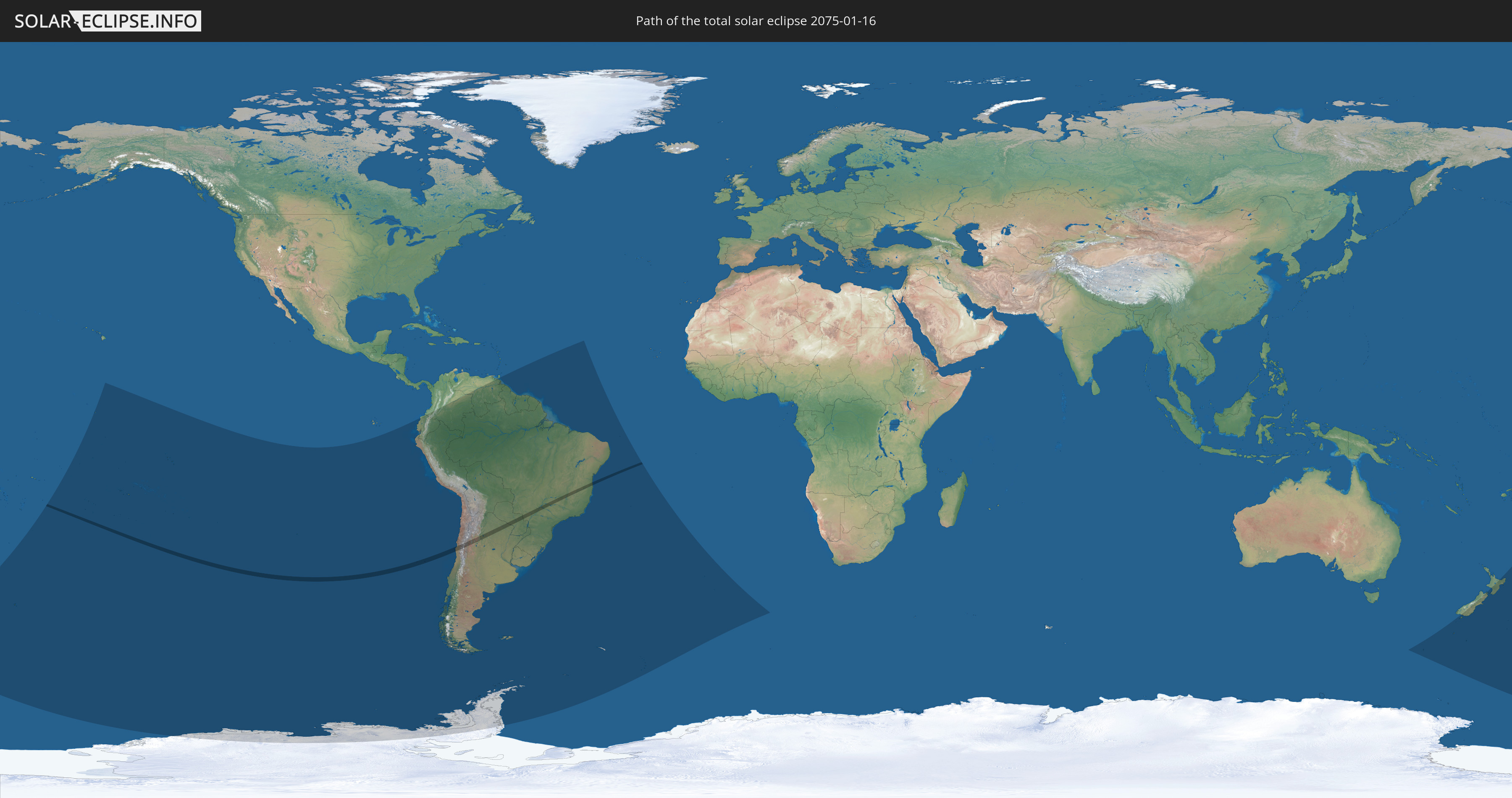
Die Sonnenfinsternis am 01/16/2075 kann man in 23 Ländern als partielle Sonnenfinsternis beobachten.
Der Finsternispfad verläuft durch 4 Länder. Nur in diesen Ländern ist sie als total Sonnenfinsternis zu sehen.
In den folgenden Ländern ist die Sonnenfinsternis total zu sehen
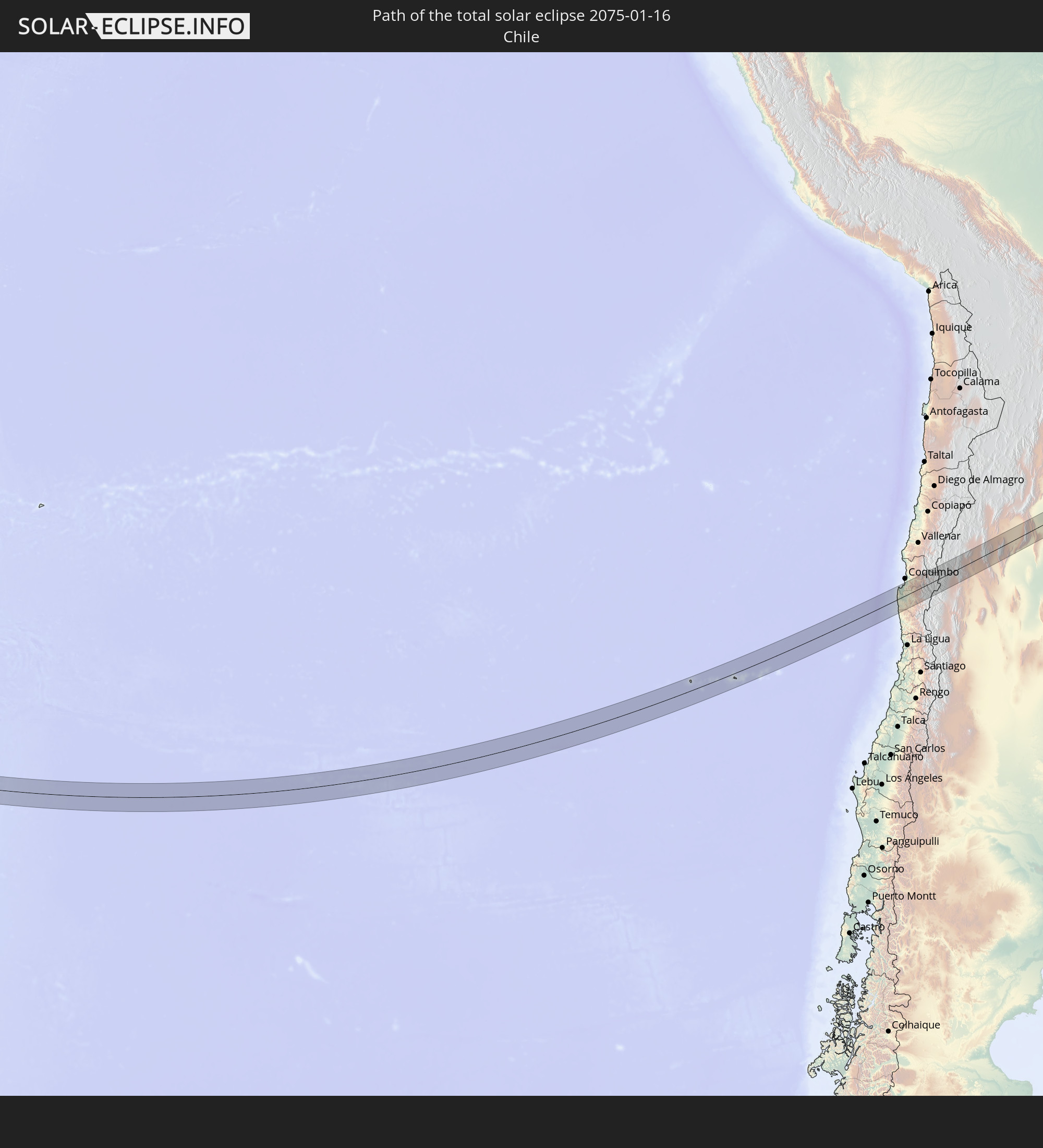 Chile
Chile
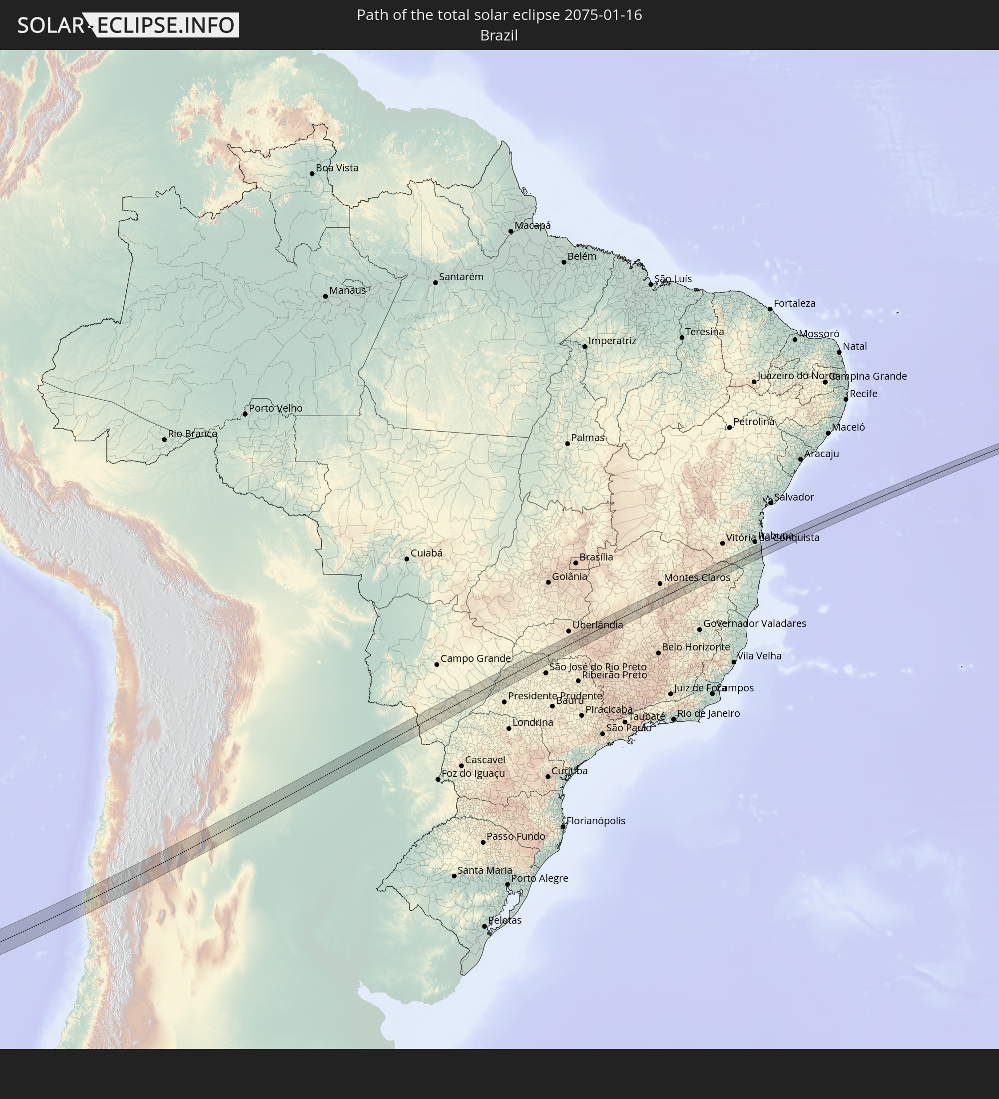 Brazil
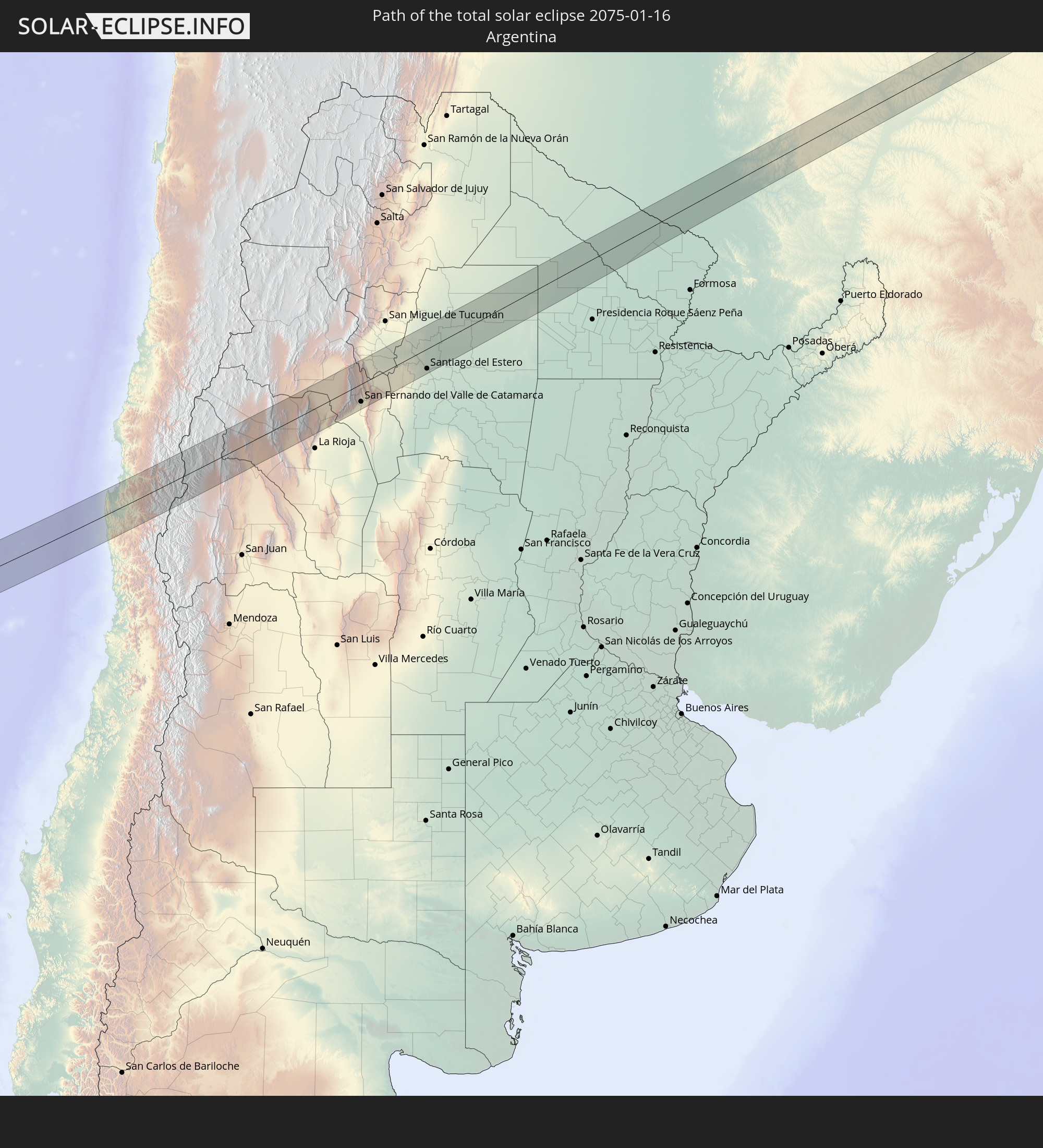 Argentina
 Paraguay
In den folgenden Ländern ist die Sonnenfinsternis partiell zu sehen
 Antarctica
 New Zealand
 Kiribati
 Cook Islands
 French Polynesia
 Pitcairn Islands
 Chile
Chile
 Ecuador
 Colombia
 Peru
Peru
 Brazil
 Argentina
 Venezuela
 Bolivia
 Paraguay
 Falkland Islands
 Guyana
 Uruguay
 Suriname
 French Guiana
 South Georgia and the South Sandwich Islands
 Saint Helena, Ascension and Tristan da Cunha
 Australia
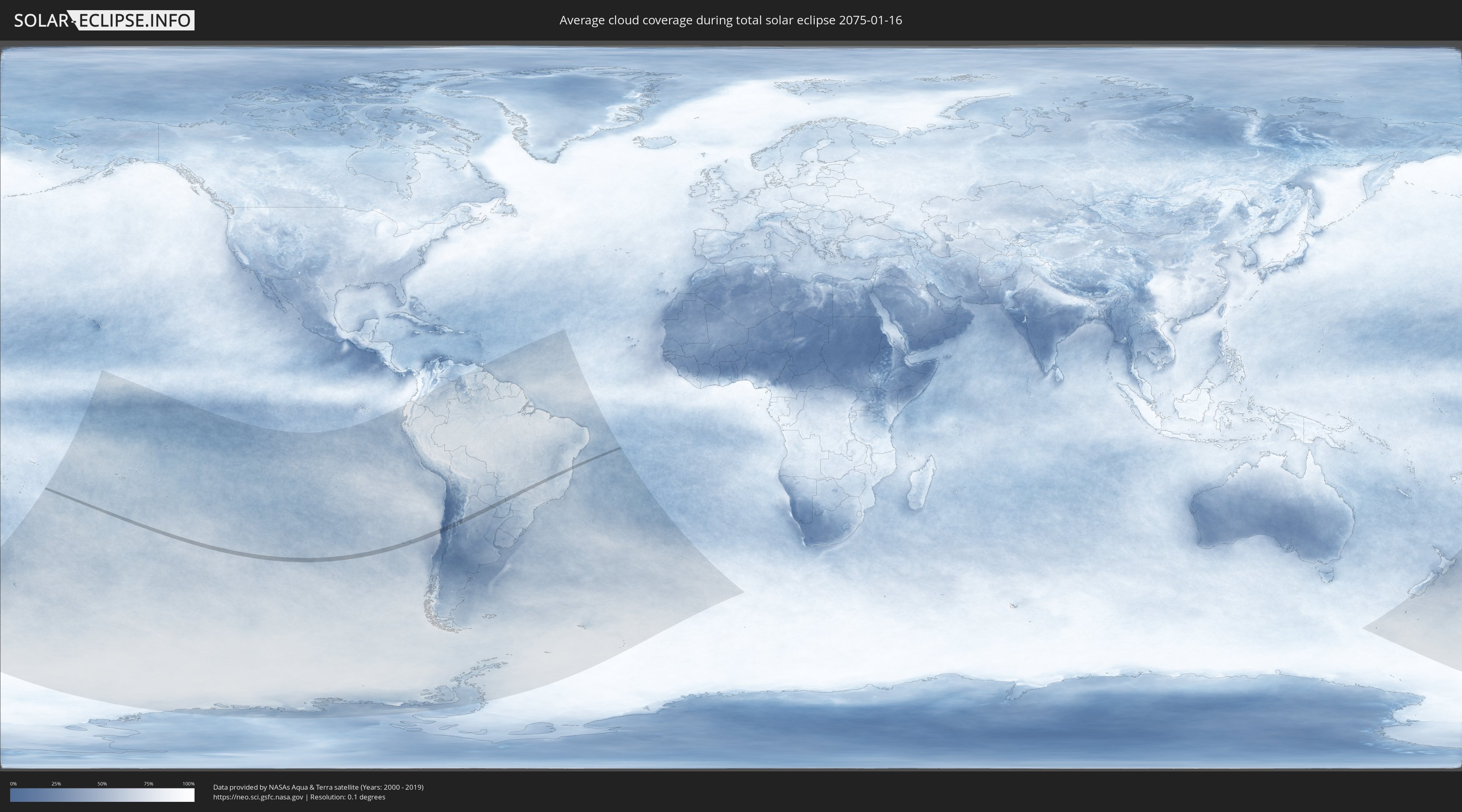
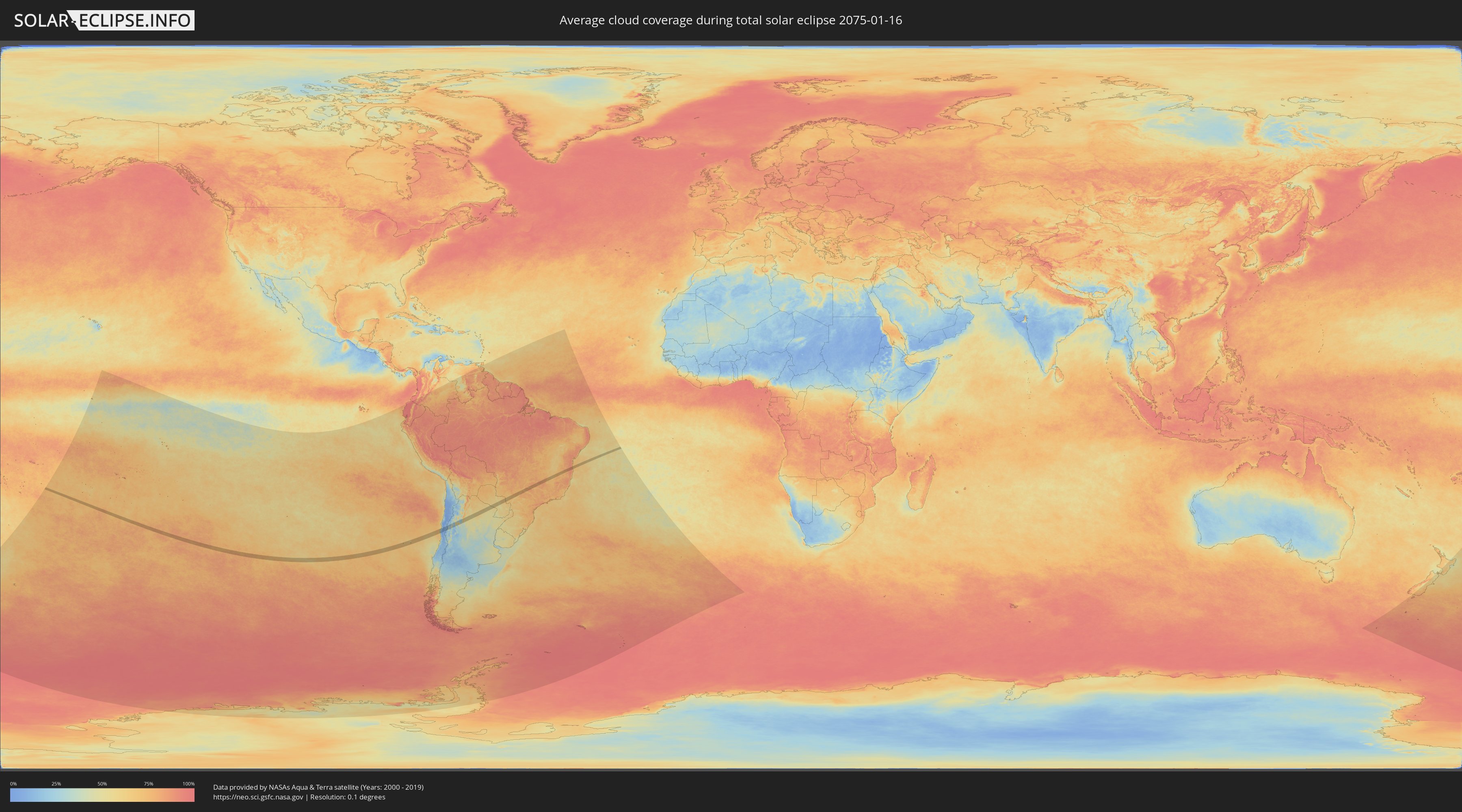
How will be the weather during the total solar eclipse on 01/16/2075?
Where is the best place to see the total solar eclipse of 01/16/2075?
The following maps show the average cloud coverage for the day of the total solar eclipse.
With the help of these maps, it is possible to find the place along the eclipse path, which has the best
chance of a cloudless sky.
Nevertheless, you should consider local circumstances and inform about the weather of your chosen
observation site.
The data is provided by NASAs satellites
AQUA and TERRA.
The cloud maps are averaged over a period of 19 years (2000 - 2019).
Detailed country maps
 Chile
Chile
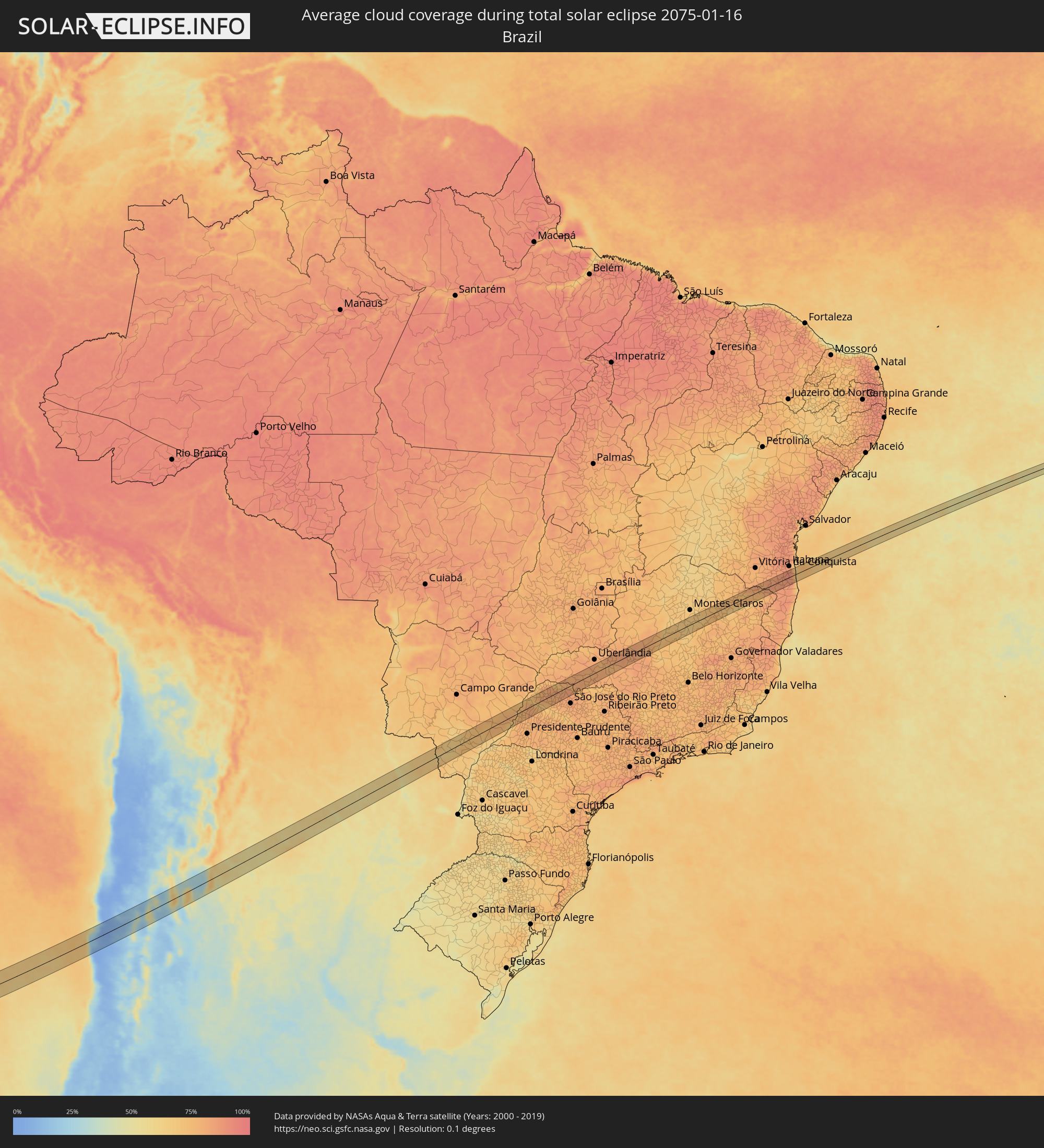 Brazil
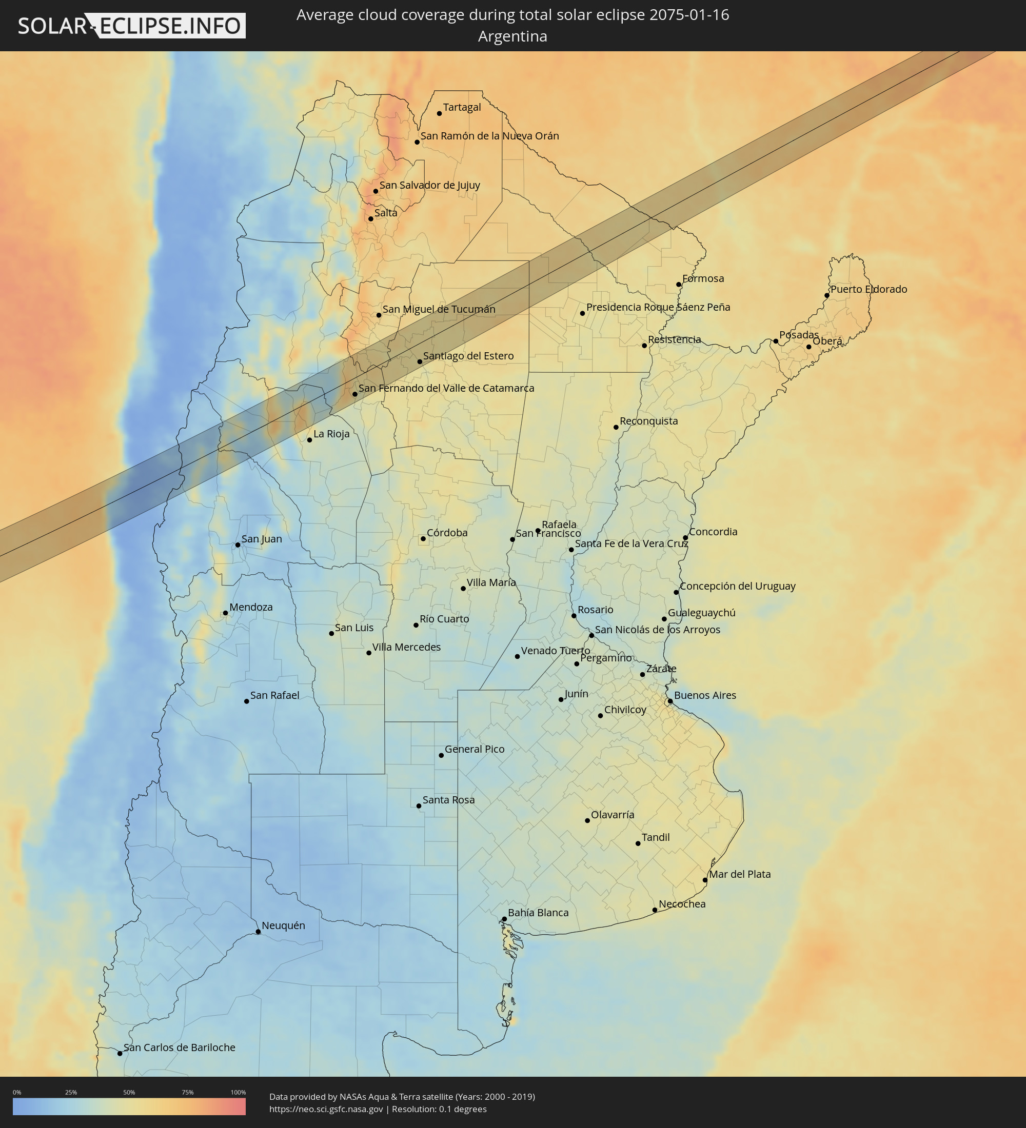 Argentina
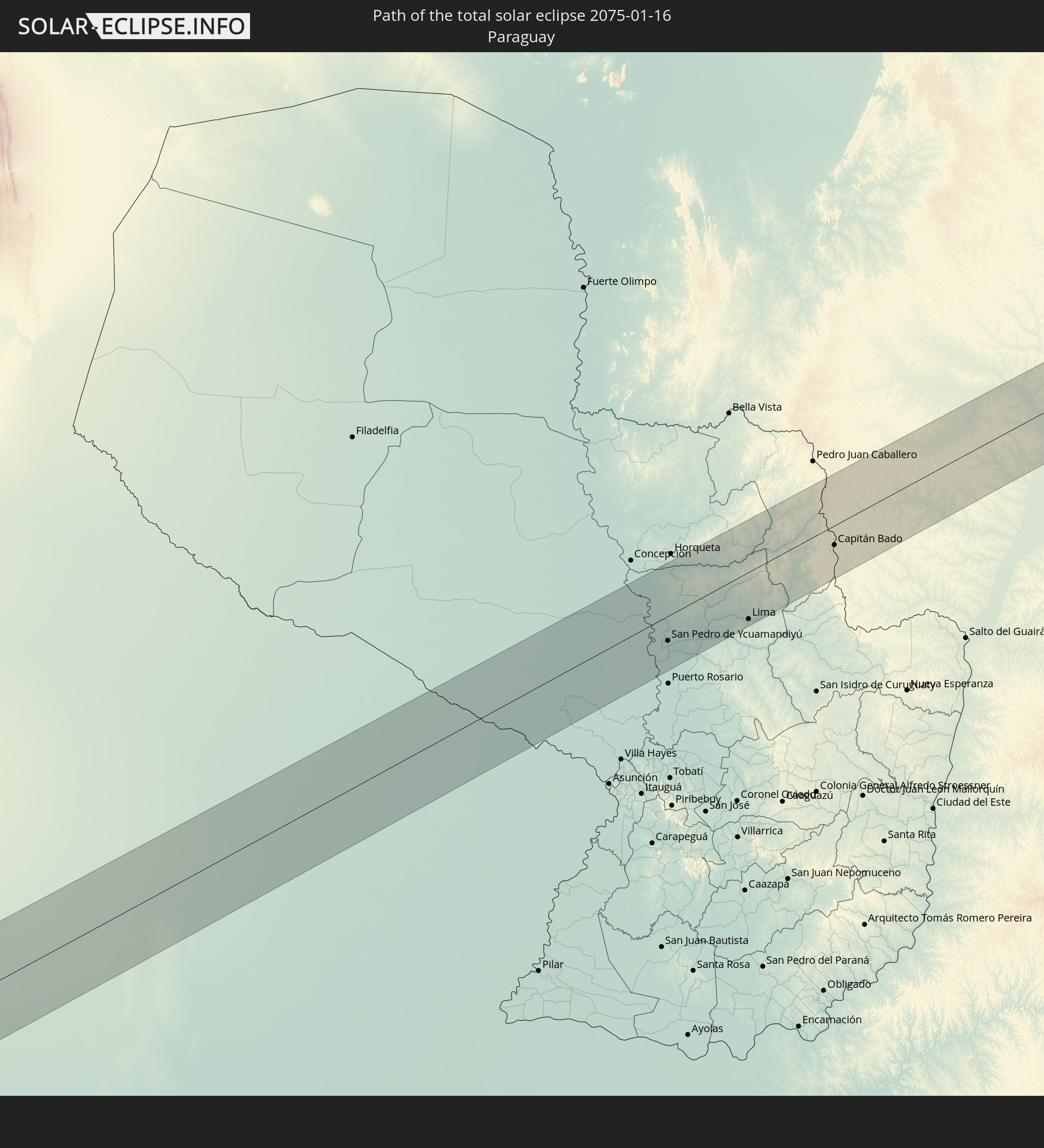
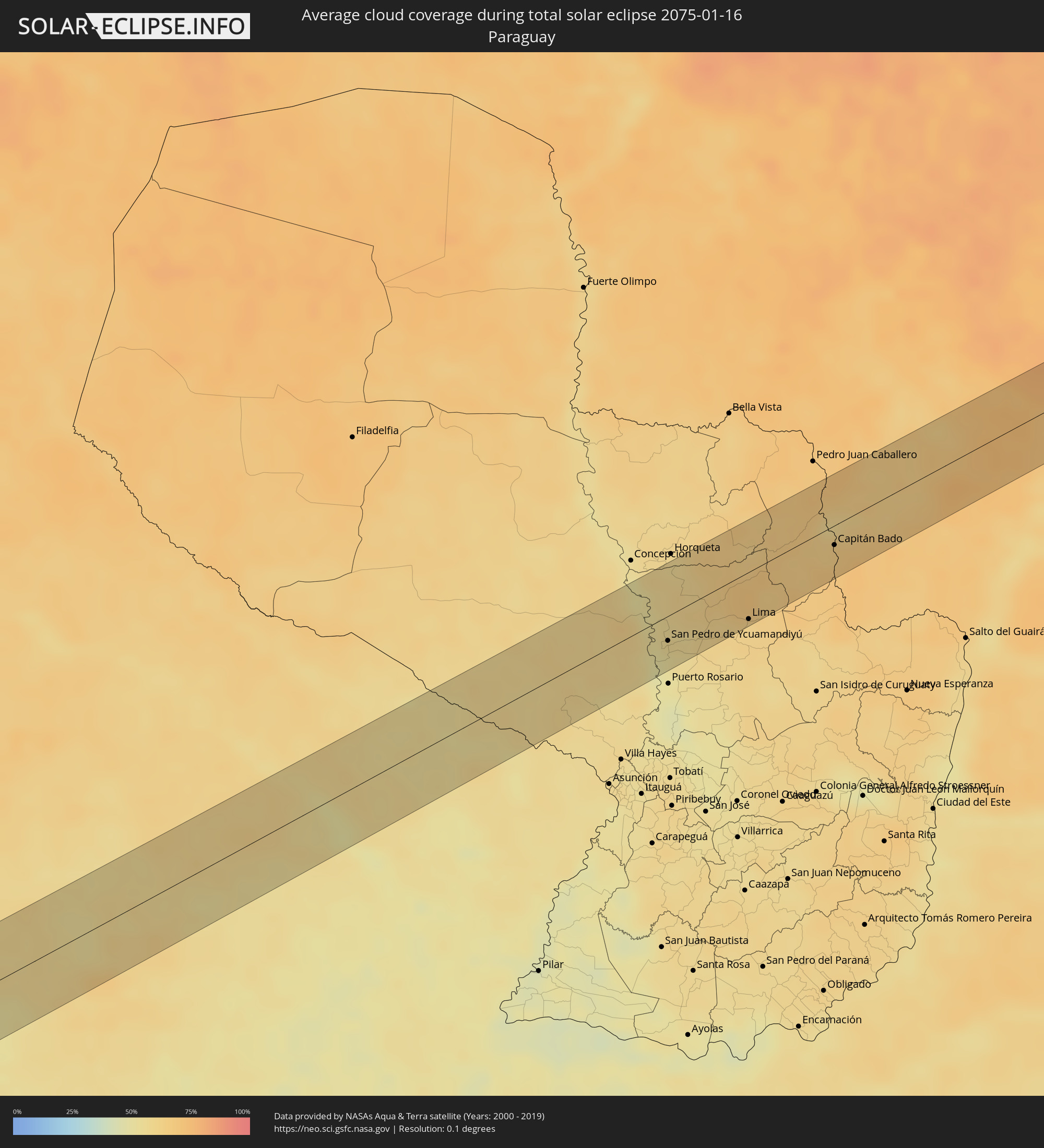 Paraguay
Cities inside the path of the eclipse
The following table shows all locations with a population of more than 5,000 inside the eclipse path. Cities which have more than 100,000 inhabitants are marked bold. A click at the locations opens a detailed map.
| City | Type | Eclipse duration | Local time of max. eclipse | Distance to central line | Ø Cloud coverage |
|
Ovalle, Coquimbo
|
total | - | 16:26:37 UTC-03:00 | 7 km | 11% |
|
Monte Patria, Coquimbo
|
total | - | 16:26:52 UTC-03:00 | 26 km | 7% |
|
Vicuña, Coquimbo
|
total | - | 16:28:10 UTC-03:00 | 29 km | 5% |
|
Chilecito, La Rioja Province
|
total | - | 16:34:06 UTC-03:00 | 26 km | 31% |
|
Arauco, La Rioja Province
|
total | - | 16:35:53 UTC-03:00 | 1 km | 33% |
|
San Fernando del Valle de Catamarca, Catamarca Province
|
total | - | 16:37:23 UTC-03:00 | 35 km | 47% |
|
La Cocha, Tucumán Province
|
total | - | 16:38:38 UTC-03:00 | 23 km | 58% |
|
Los Altos, Catamarca Province
|
total | - | 16:38:21 UTC-03:00 | 7 km | 56% |
|
Graneros, Tucumán Province
|
total | - | 16:38:59 UTC-03:00 | 29 km | 57% |
|
Termas de Río Hondo, Santiago del Estero Province
|
total | - | 16:39:56 UTC-03:00 | 18 km | 51% |
|
Santiago del Estero, Santiago del Estero Province
|
total | - | 16:40:15 UTC-03:00 | 40 km | 51% |
|
Clodomira, Santiago del Estero Province
|
total | - | 16:40:43 UTC-03:00 | 24 km | 53% |
|
Campo Gallo, Santiago del Estero Province
|
total | - | 16:43:37 UTC-03:00 | 13 km | 57% |
|
Los Frentones, Chaco Province
|
total | - | 16:45:28 UTC-03:00 | 39 km | 54% |
|
Castelli, Chaco Province
|
total | - | 16:46:56 UTC-03:00 | 32 km | 54% |
|
Ibarreta, Formosa Province
|
total | - | 16:48:43 UTC-03:00 | 3 km | 57% |
|
Comandante Fontana, Formosa Province
|
total | - | 16:48:43 UTC-03:00 | 17 km | 56% |
|
San Pedro de Ycuamandiyú, San Pedro
|
total | - | 16:52:48 UTC-03:00 | 21 km | 52% |
|
Lima, San Pedro
|
total | - | 16:53:41 UTC-03:00 | 39 km | 60% |
|
Capitán Bado, Amambay
|
total | - | 16:55:09 UTC-03:00 | 16 km | 65% |
|
Caarapó, Mato Grosso do Sul
|
total | - | 15:56:30 UTC-04:00 | 11 km | 64% |
|
Bataiporã, Mato Grosso do Sul
|
total | - | 15:58:02 UTC-04:00 | 32 km | 67% |
|
Presidente Epitácio, São Paulo
|
total | - | 16:59:27 UTC-03:00 | 36 km | 70% |
|
Panorama, São Paulo
|
total | - | 17:00:07 UTC-03:00 | 9 km | 72% |
|
Três Lagoas, Mato Grosso do Sul
|
total | - | 16:00:53 UTC-04:00 | 40 km | 70% |
|
Tupi Paulista, São Paulo
|
total | - | 17:00:15 UTC-03:00 | 25 km | 77% |
|
Castilho, São Paulo
|
total | - | 17:00:55 UTC-03:00 | 21 km | 78% |
|
Andradina, São Paulo
|
total | - | 17:00:57 UTC-03:00 | 13 km | 79% |
|
Pereira Barreto, São Paulo
|
total | - | 17:01:25 UTC-03:00 | 25 km | 72% |
|
Mirandopólis, São Paulo
|
total | - | 17:00:50 UTC-03:00 | 24 km | 80% |
|
Auriflama, São Paulo
|
total | - | 17:01:41 UTC-03:00 | 6 km | 78% |
|
Jales, São Paulo
|
total | - | 17:02:10 UTC-03:00 | 34 km | 79% |
|
General Salgado, São Paulo
|
total | - | 17:01:50 UTC-03:00 | 12 km | 78% |
|
Fernandópolis, São Paulo
|
total | - | 17:02:19 UTC-03:00 | 18 km | 80% |
|
Nhandeara, São Paulo
|
total | - | 17:01:57 UTC-03:00 | 32 km | 80% |
|
Votuporanga, São Paulo
|
total | - | 17:02:18 UTC-03:00 | 9 km | 79% |
|
Cardoso, São Paulo
|
total | - | 17:02:44 UTC-03:00 | 22 km | 79% |
|
Riolândia, São Paulo
|
total | - | 17:02:58 UTC-03:00 | 21 km | 79% |
|
Frutal, Minas Gerais
|
total | - | 17:03:18 UTC-03:00 | 19 km | 81% |
|
Conceição das Alagoas, Minas Gerais
|
total | - | 17:03:41 UTC-03:00 | 35 km | 77% |
|
Patrocínio, Minas Gerais
|
total | - | 17:05:23 UTC-03:00 | 6 km | 84% |
|
Patos de Minas, Minas Gerais
|
total | - | 17:05:58 UTC-03:00 | 7 km | 83% |
|
Presidente Olegário, Minas Gerais
|
total | - | 17:06:11 UTC-03:00 | 19 km | 81% |
|
Lagoa Formosa, Minas Gerais
|
total | - | 17:05:47 UTC-03:00 | 18 km | 81% |
|
Várzea da Palma, Minas Gerais
|
total | - | 17:07:38 UTC-03:00 | 20 km | 69% |
|
Bocaiúva, Minas Gerais
|
total | - | 17:08:24 UTC-03:00 | 26 km | 67% |
|
Araçuaí, Minas Gerais
|
total | - | 17:09:05 UTC-03:00 | 30 km | 68% |
|
Medina, Minas Gerais
|
total | - | 17:09:49 UTC-03:00 | 5 km | 75% |
|
Pedra Azul, Minas Gerais
|
total | - | 17:10:04 UTC-03:00 | 19 km | 75% |
|
Almenara, Minas Gerais
|
total | - | 17:10:00 UTC-03:00 | 27 km | 74% |
|
Itarantim, Bahia
|
total | - | 17:10:36 UTC-03:00 | 3 km | 82% |
|
Pau Brasil, Bahia
|
total | - | 17:10:50 UTC-03:00 | 2 km | 84% |
|
Mascote, Bahia
|
total | - | 17:10:47 UTC-03:00 | 28 km | 87% |
|
Buerarema, Bahia
|
total | - | 17:11:20 UTC-03:00 | 33 km | 90% |
|
Una, Bahia
|
total | - | 17:11:03 UTC-03:00 | 11 km | 78% |