Total solar eclipse of 09/23/2090
| Day of week: | Saturday |
| Maximum duration of eclipse: | 03m36s |
| Maximum width of eclipse path: | 463 km |
| Saros cycle: | 155 |
| Coverage: | 100% |
| Magnitude: | 1.0562 |
| Gamma: | 0.9157 |
Wo kann man die Sonnenfinsternis vom 09/23/2090 sehen?
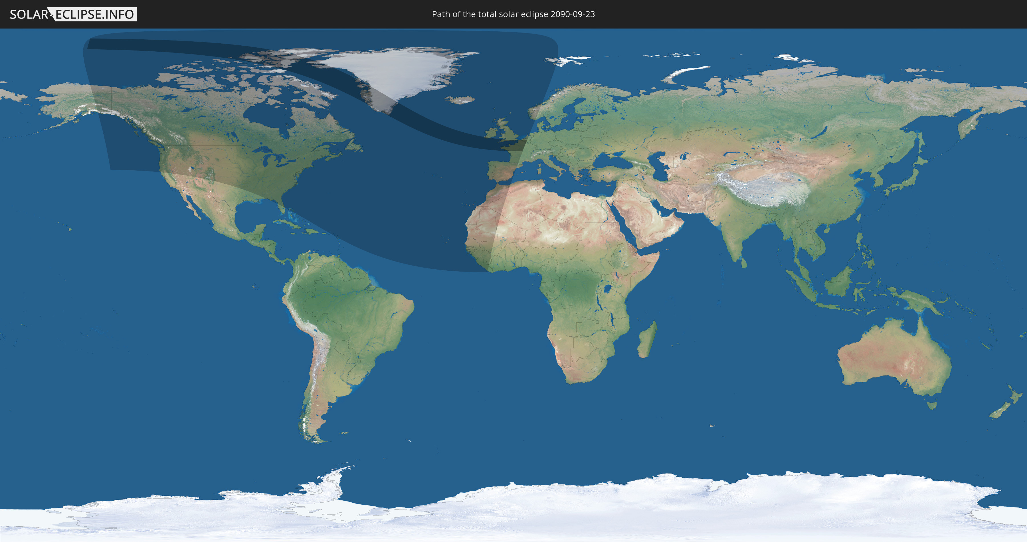
Die Sonnenfinsternis am 09/23/2090 kann man in 38 Ländern als partielle Sonnenfinsternis beobachten.
Der Finsternispfad verläuft durch 8 Länder. Nur in diesen Ländern ist sie als total Sonnenfinsternis zu sehen.
In den folgenden Ländern ist die Sonnenfinsternis total zu sehen
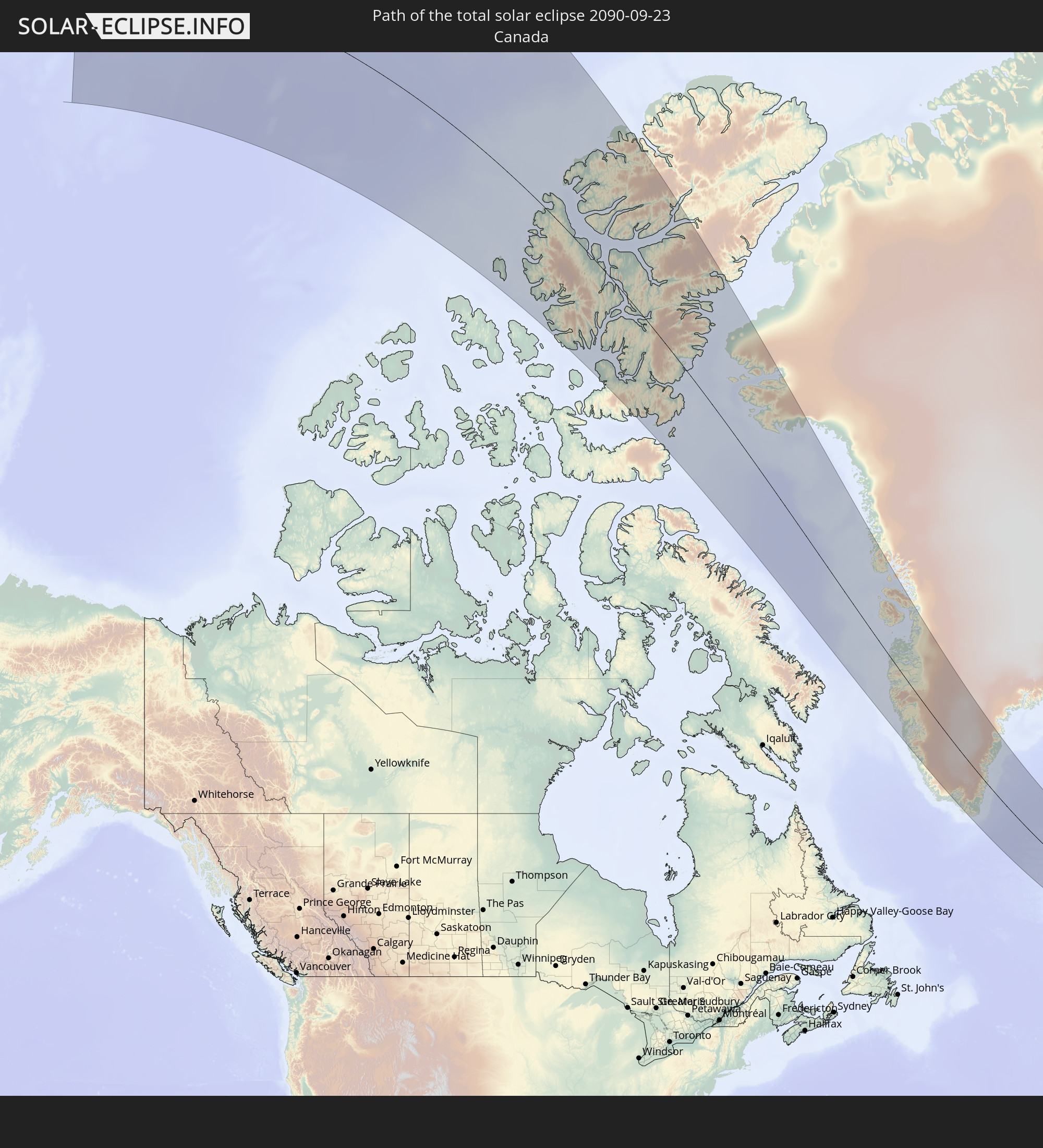 Canada
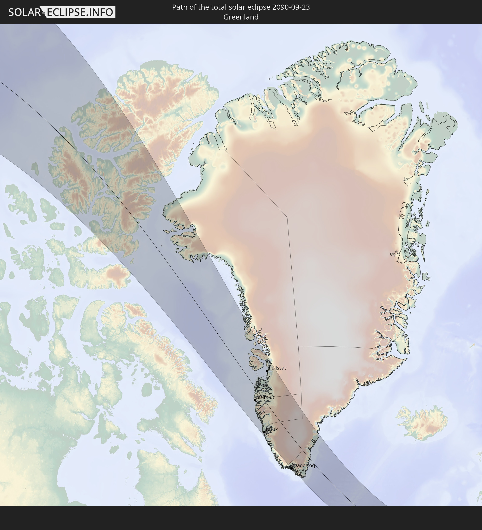 Greenland
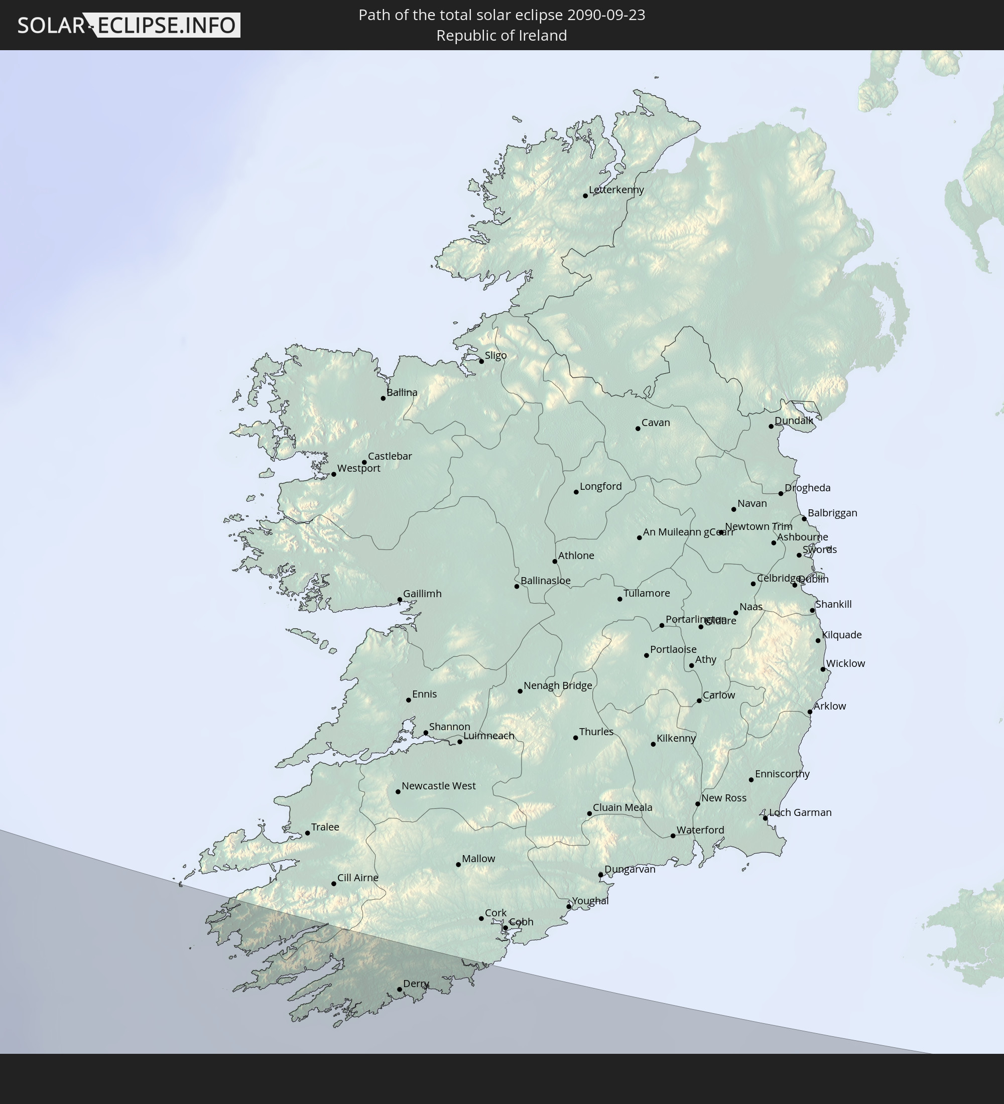 Republic of Ireland
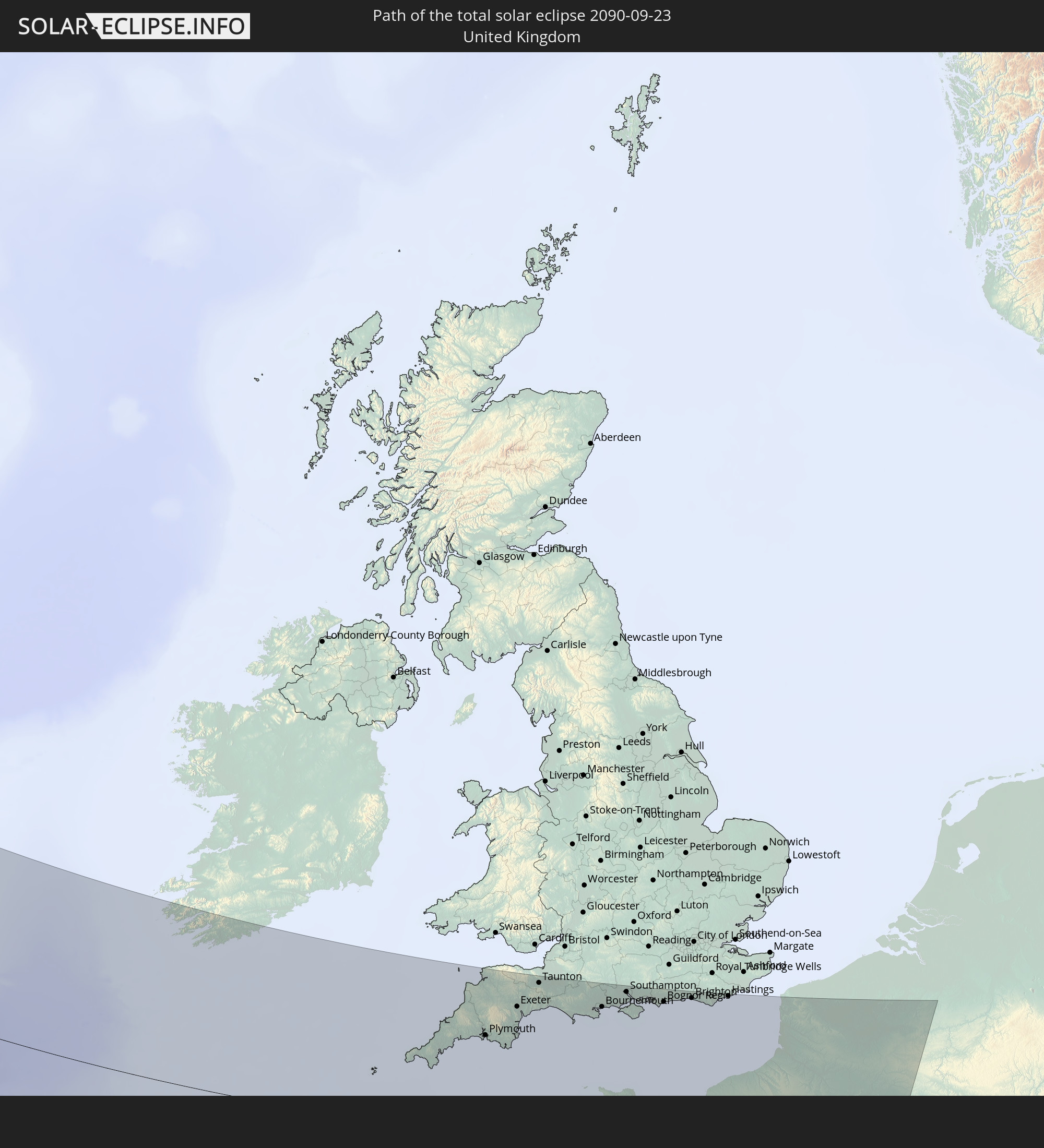 United Kingdom
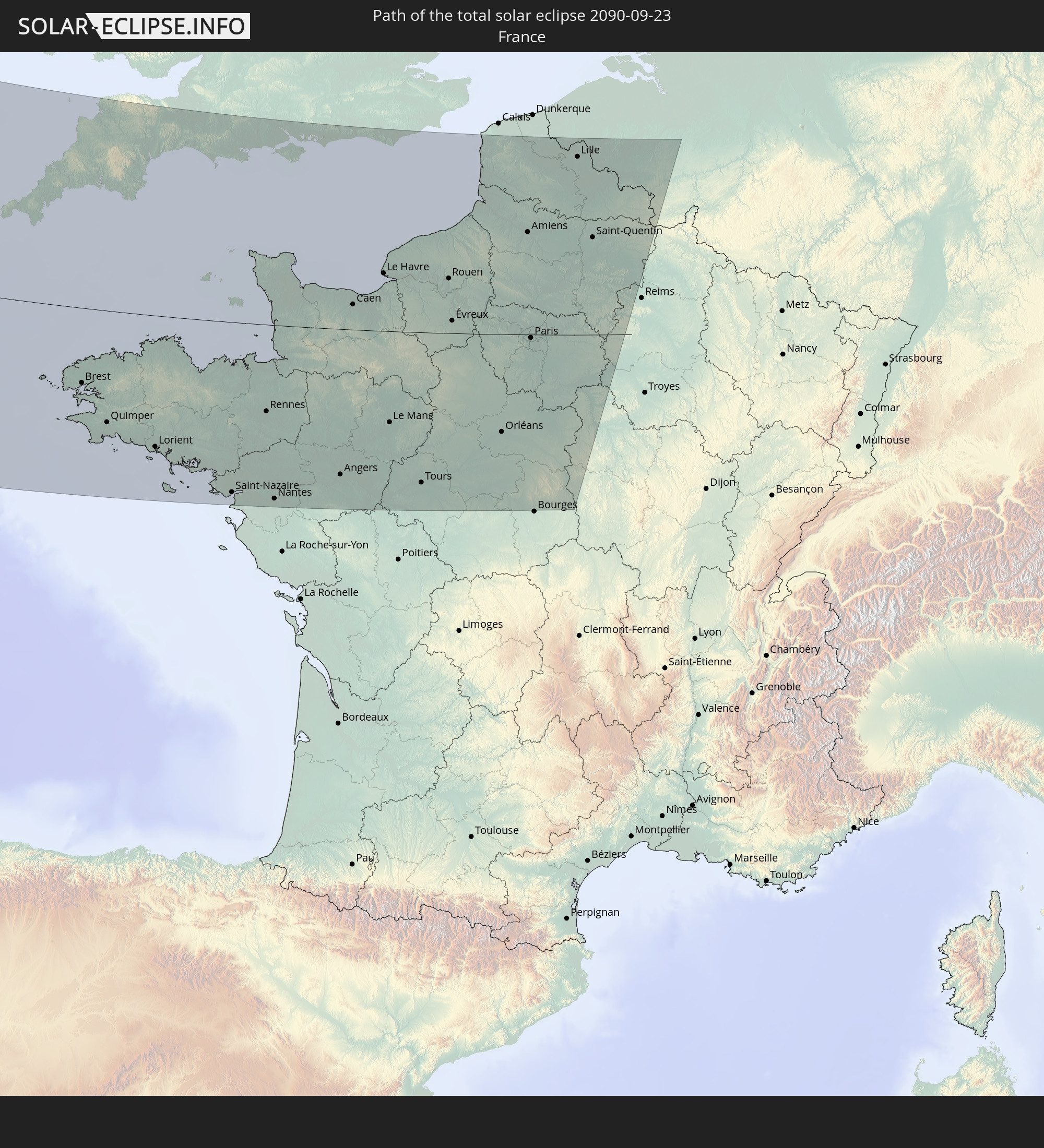 France
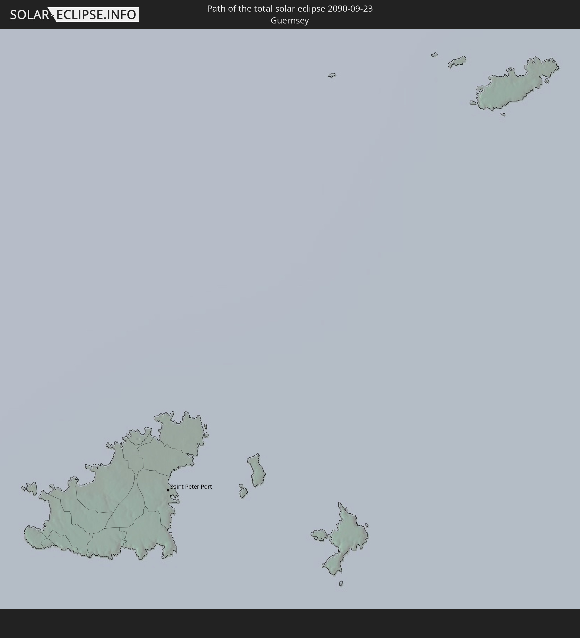 Guernsey
 Jersey
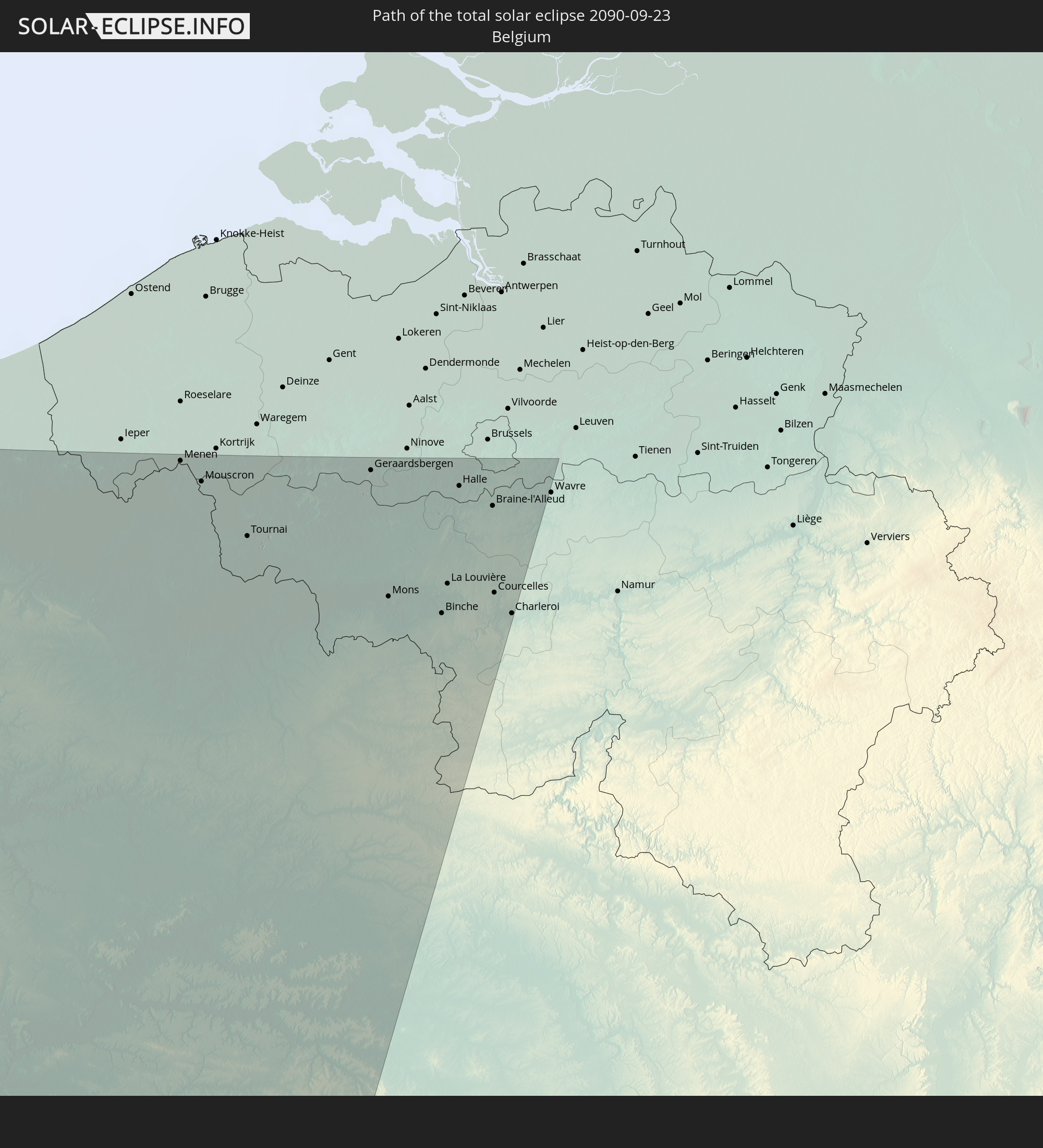 Belgium
In den folgenden Ländern ist die Sonnenfinsternis partiell zu sehen
 United States
 Canada
 Greenland
 The Bahamas
 Bermuda
 British Virgin Islands
 Anguilla
 Collectivity of Saint Martin
 Saint Barthélemy
 Antigua and Barbuda
 Saint Pierre and Miquelon
 Portugal
 Cabo Verde
 Iceland
 Spain
Spain
 Senegal
 Mauritania
 The Gambia
 Guinea-Bissau
 Guinea
 Sierra Leone
 Morocco
 Mali
Mali
 Liberia
 Republic of Ireland
 Svalbard and Jan Mayen
 Algeria
 United Kingdom
 Faroe Islands
 Gibraltar
 France
 Isle of Man
 Guernsey
 Jersey
 Andorra
 Belgium
 Netherlands
 Norway
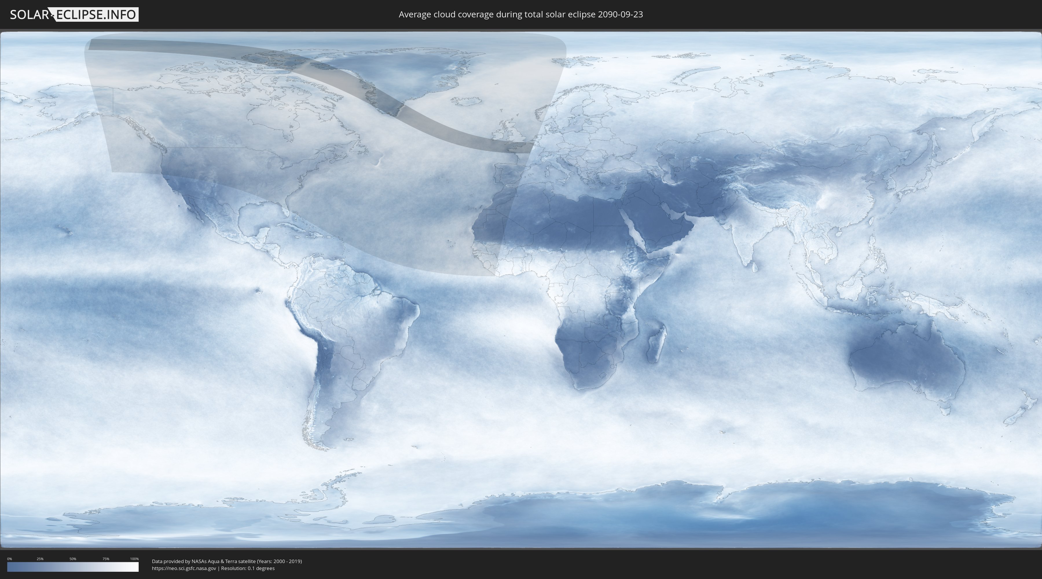
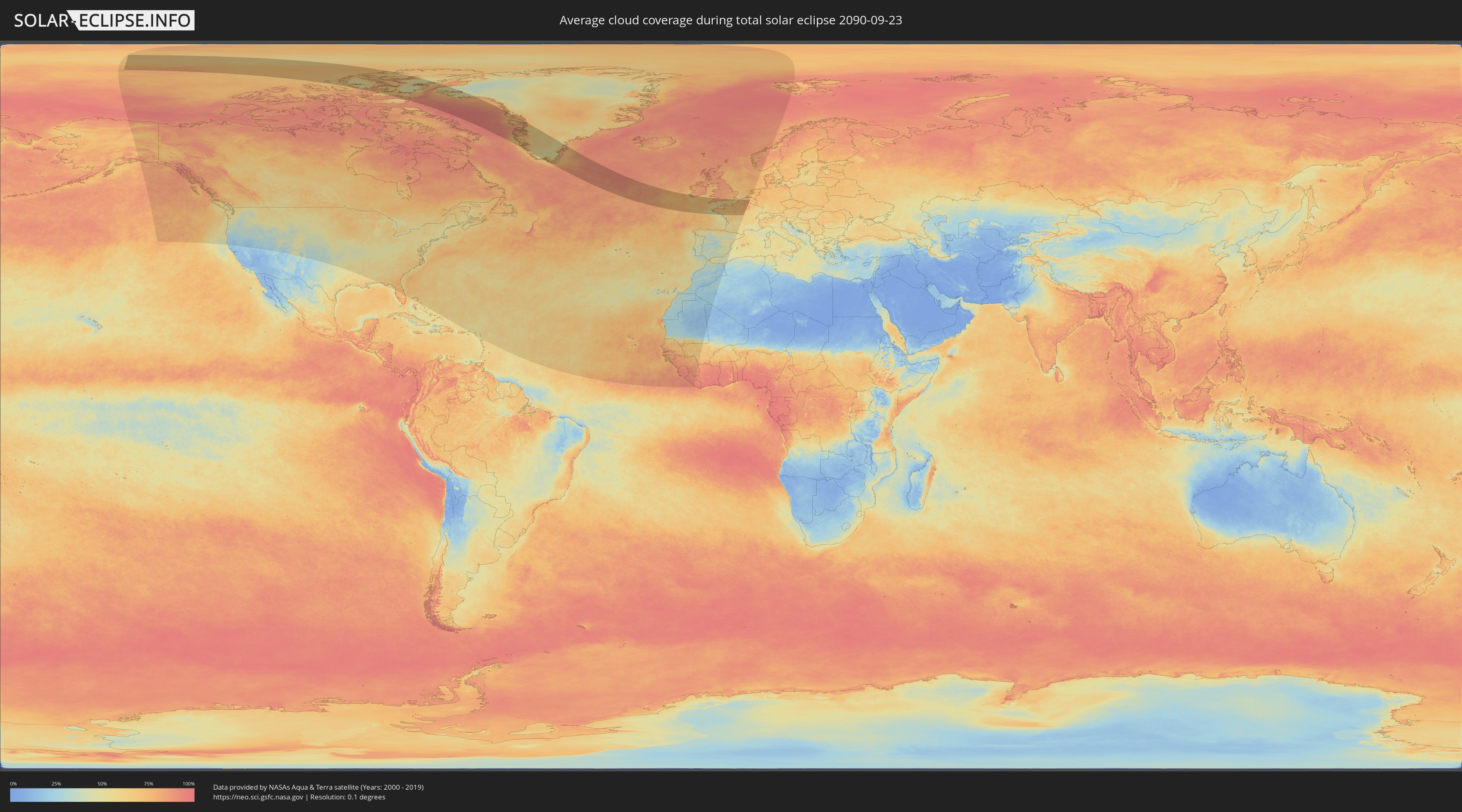
How will be the weather during the total solar eclipse on 09/23/2090?
Where is the best place to see the total solar eclipse of 09/23/2090?
The following maps show the average cloud coverage for the day of the total solar eclipse.
With the help of these maps, it is possible to find the place along the eclipse path, which has the best
chance of a cloudless sky.
Nevertheless, you should consider local circumstances and inform about the weather of your chosen
observation site.
The data is provided by NASAs satellites
AQUA and TERRA.
The cloud maps are averaged over a period of 19 years (2000 - 2019).
Detailed country maps
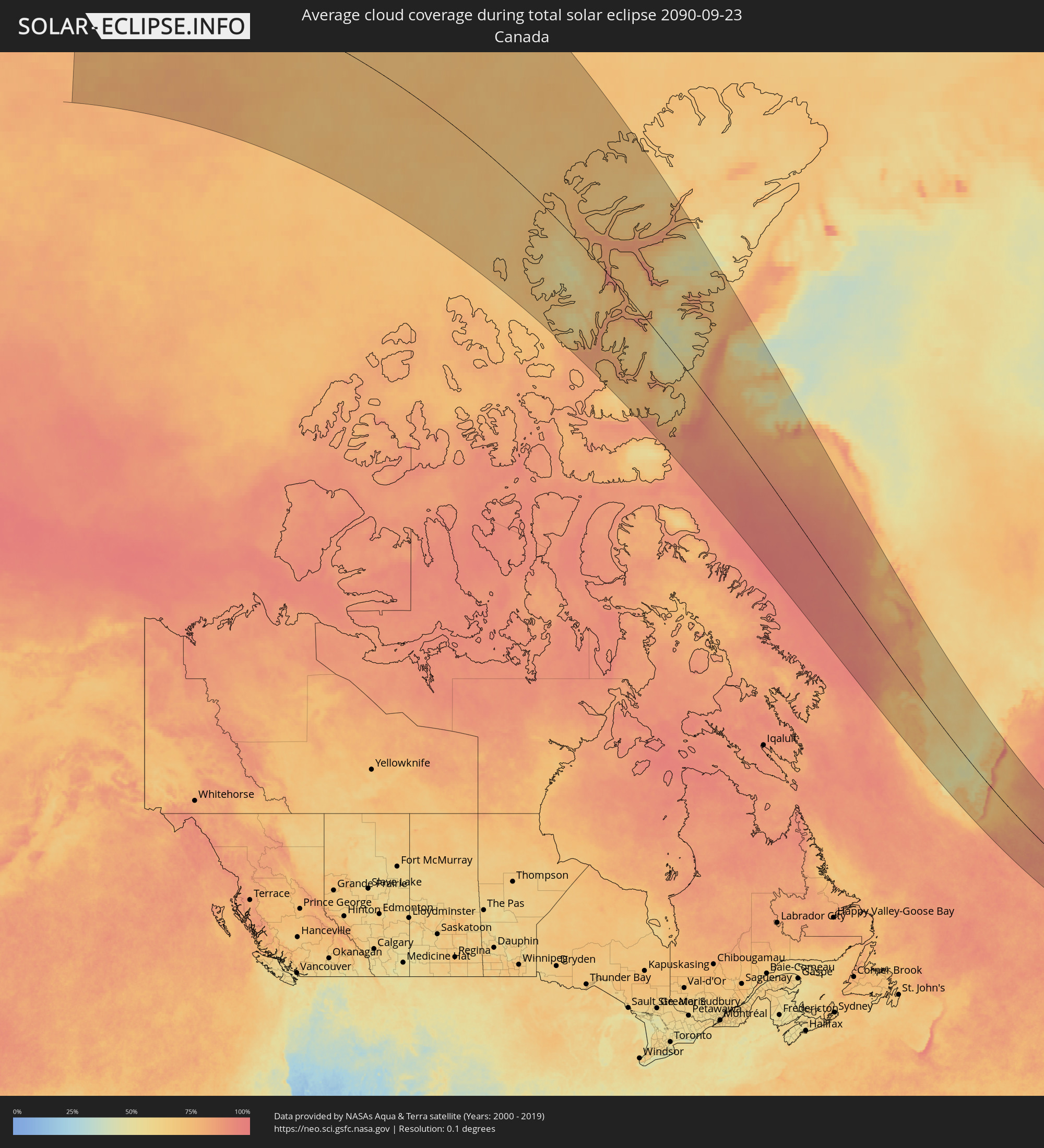 Canada
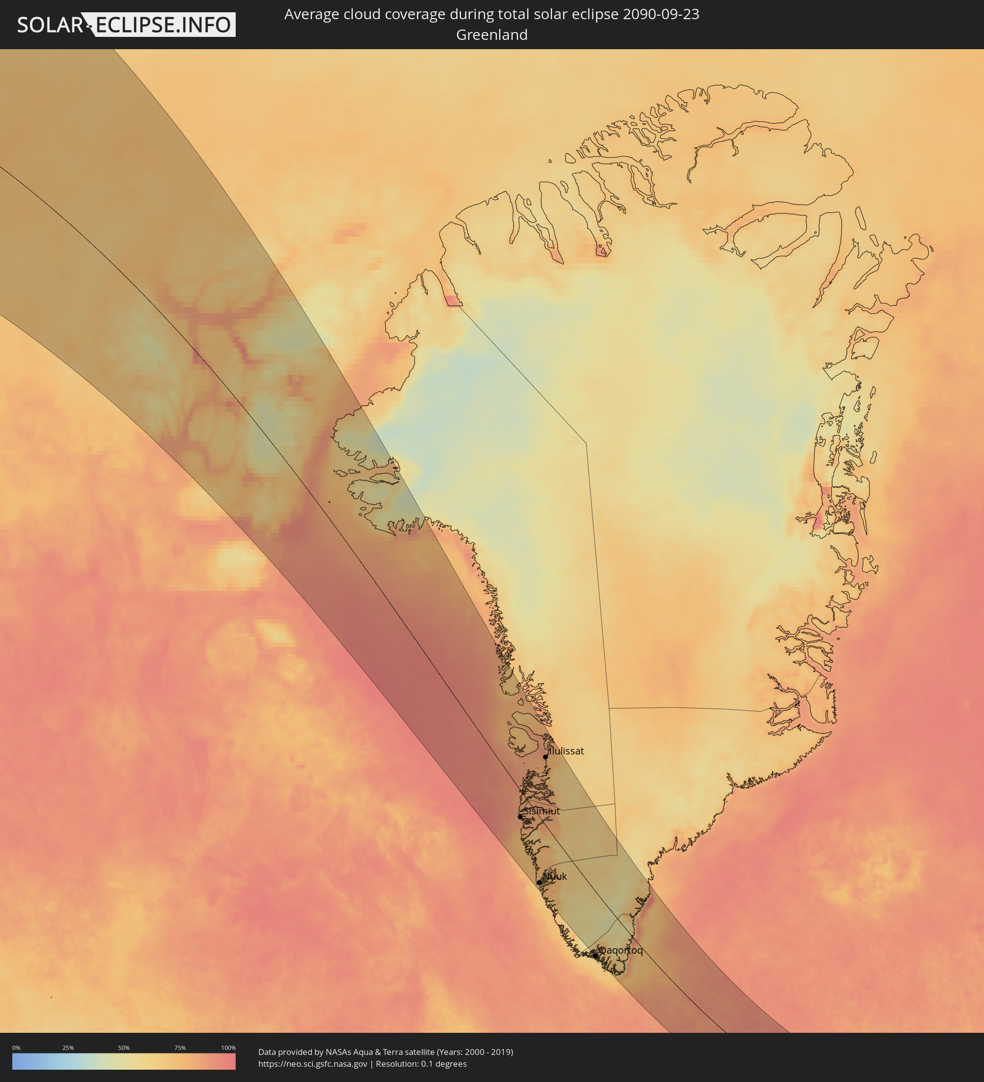 Greenland
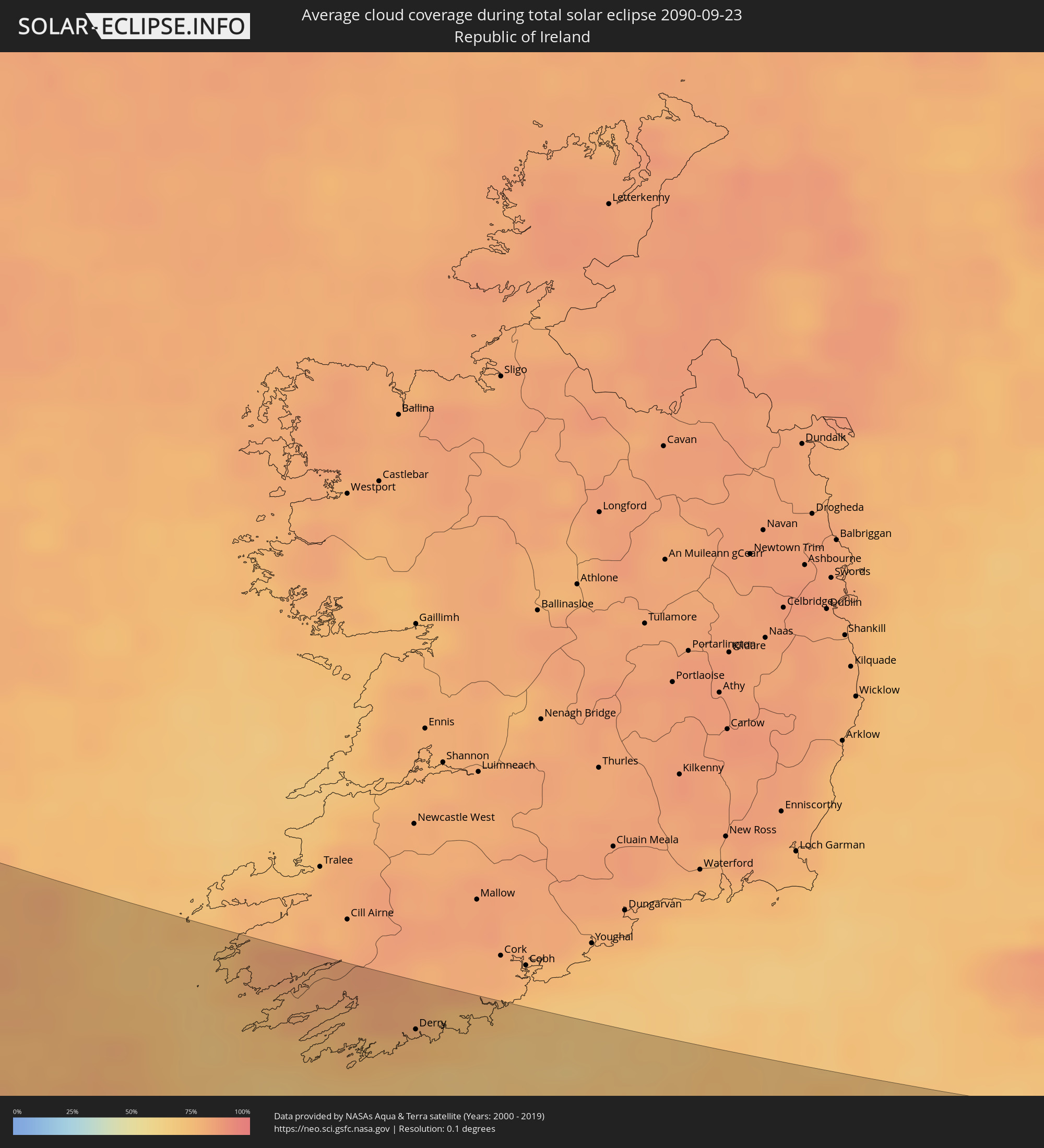 Republic of Ireland
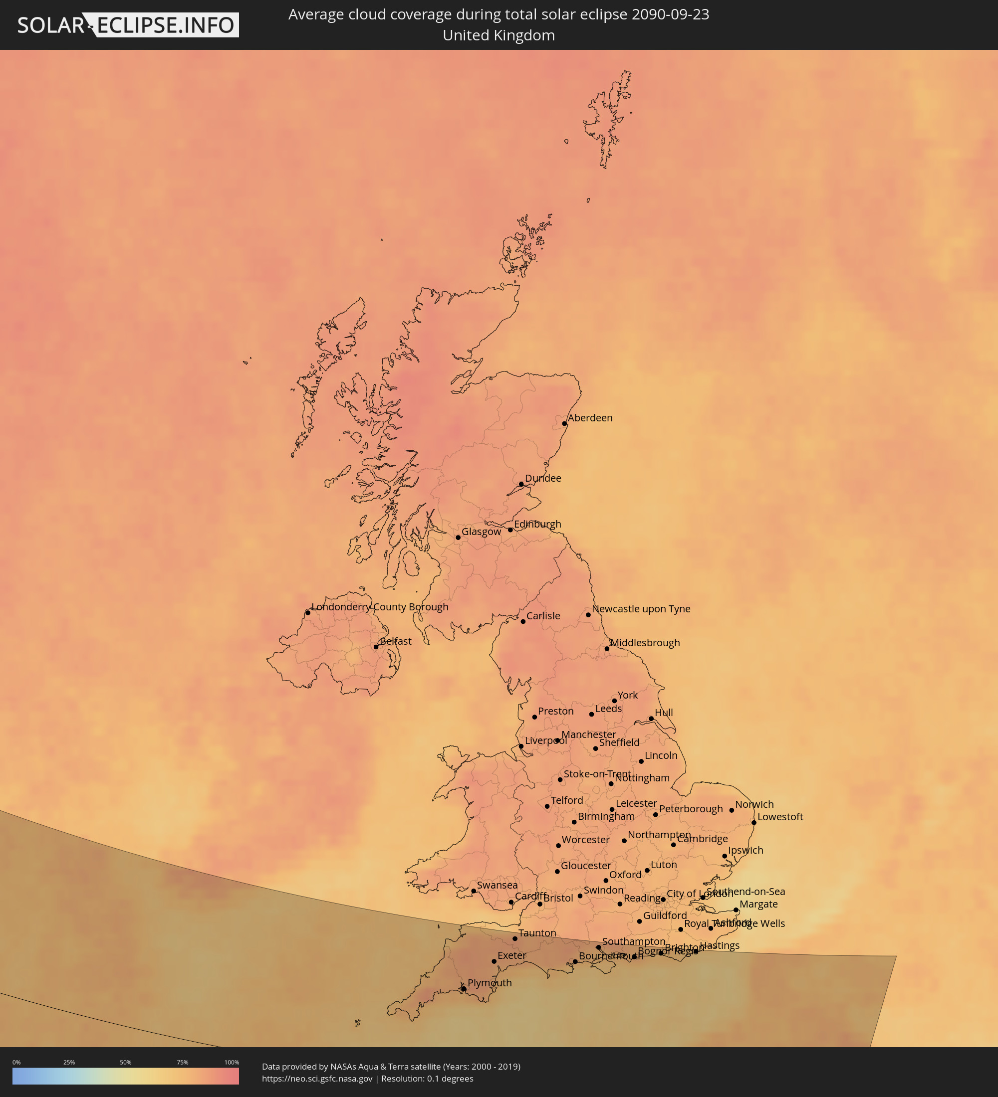 United Kingdom
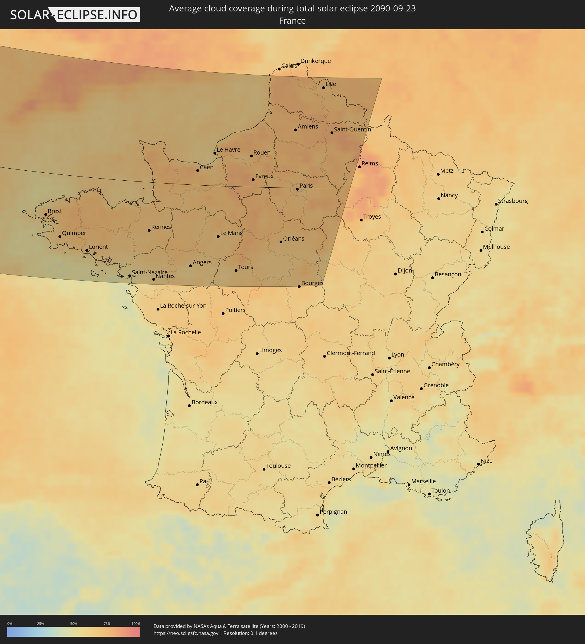 France
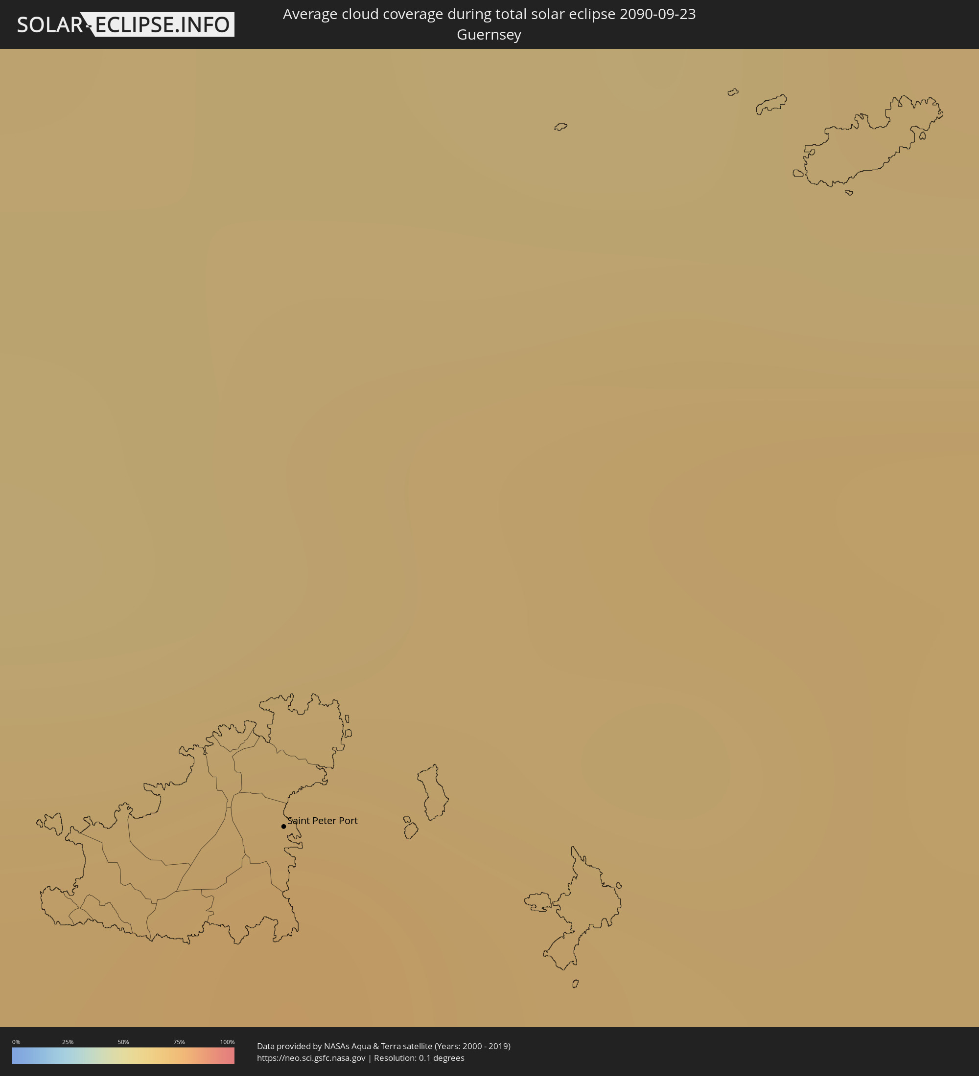 Guernsey
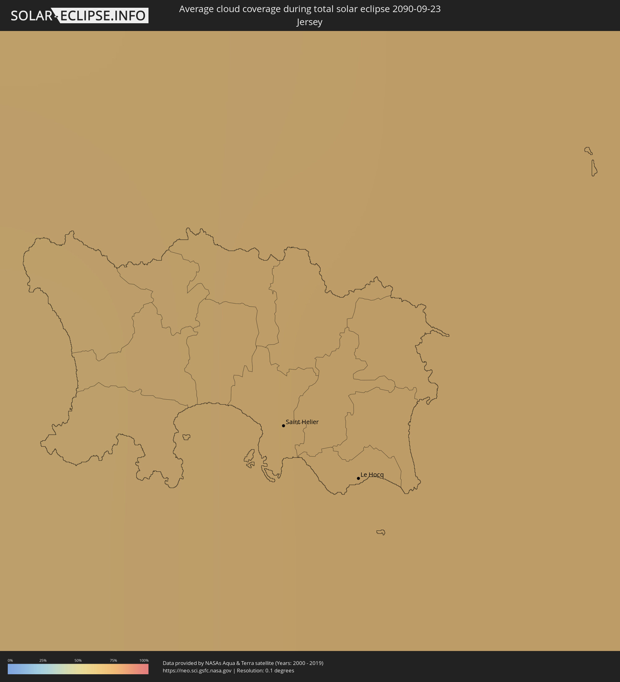 Jersey
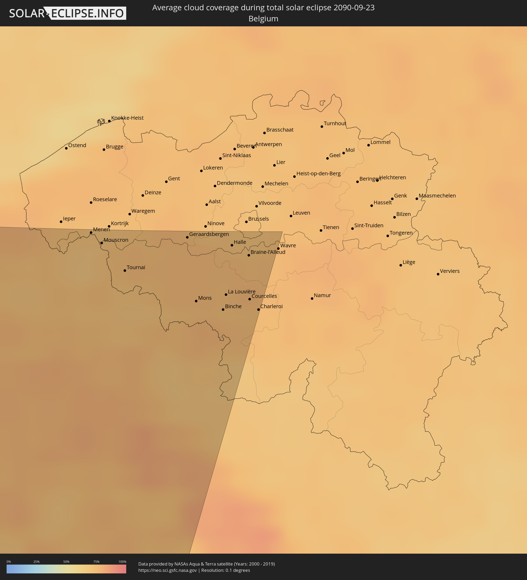 Belgium
Cities inside the path of the eclipse
The following table shows all locations with a population of more than 5,000 inside the eclipse path. Cities which have more than 100,000 inhabitants are marked bold. A click at the locations opens a detailed map.
| City | Type | Eclipse duration | Local time of max. eclipse | Distance to central line | Ø Cloud coverage |
|
Sisimiut, Qeqqata
|
total | - | 13:36:04 UTC-03:00 | 69 km | 82% |
|
Nuuk, Sermersooq
|
total | - | 13:40:07 UTC-03:00 | 189 km | 74% |
|
Ilulissat, Qaasuitsup
|
total | - | 13:35:54 UTC-03:00 | 163 km | 79% |
|
Derry, Munster
|
total | - | 17:27:45 UTC+00:00 | 215 km | 76% |
|
Bandon, Munster
|
total | - | 17:27:33 UTC+00:00 | 237 km | 73% |
|
Penzance, England
|
total | - | 17:31:14 UTC+00:00 | 97 km | 72% |
|
Camborne, England
|
total | - | 17:31:08 UTC+00:00 | 110 km | 77% |
|
Newquay, England
|
total | - | 17:30:49 UTC+00:00 | 135 km | 81% |
|
Falmouth, England
|
total | - | 17:31:17 UTC+00:00 | 106 km | 76% |
|
St Austell, England
|
total | - | 17:31:01 UTC+00:00 | 129 km | 74% |
|
Brest, Brittany
|
total | - | 18:34:25 UTC+01:00 | 83 km | 64% |
|
Tavistock, England
|
total | - | 17:30:47 UTC+00:00 | 157 km | 81% |
|
Plymouth, England
|
total | - | 17:31:05 UTC+00:00 | 138 km | 76% |
|
Quimper, Brittany
|
total | - | 18:35:10 UTC+01:00 | 124 km | 65% |
|
Barnstaple, England
|
total | - | 17:29:52 UTC+00:00 | 217 km | 79% |
|
Ivybridge, England
|
total | - | 17:31:06 UTC+00:00 | 142 km | 79% |
|
Exeter, England
|
total | - | 17:30:35 UTC+00:00 | 181 km | 77% |
|
Torquay, England
|
total | - | 17:31:03 UTC+00:00 | 153 km | 74% |
|
Tiverton, England
|
total | - | 17:30:17 UTC+00:00 | 202 km | 81% |
|
Lorient, Brittany
|
total | - | 18:35:43 UTC+01:00 | 147 km | 63% |
|
Sidmouth, England
|
total | - | 17:30:42 UTC+00:00 | 180 km | 75% |
|
Taunton, England
|
total | - | 17:30:10 UTC+00:00 | 217 km | 82% |
|
Chard, England
|
total | - | 17:30:26 UTC+00:00 | 202 km | 80% |
|
Saint-Brieuc, Brittany
|
total | - | 18:34:31 UTC+01:00 | 58 km | 73% |
|
Bridport, England
|
total | - | 17:30:42 UTC+00:00 | 188 km | 70% |
|
Vannes, Brittany
|
total | - | 18:35:57 UTC+01:00 | 152 km | 65% |
|
Yeovil, England
|
total | - | 17:30:22 UTC+00:00 | 212 km | 80% |
|
Saint Peter Port, St Peter Port
|
total | - | 17:32:56 UTC+00:00 | 48 km | 71% |
|
Weymouth, England
|
total | - | 17:30:58 UTC+00:00 | 177 km | 69% |
|
Saint-Nazaire, Pays de la Loire
|
total | - | 18:36:40 UTC+01:00 | 192 km | 51% |
|
Saint Helier, St Helier
|
total | - | 17:33:28 UTC+00:00 | 20 km | 67% |
|
Le Hocq, St Clement
|
total | - | 17:33:30 UTC+00:00 | 18 km | 67% |
|
Saint-Malo, Brittany
|
total | - | 18:34:23 UTC+01:00 | 39 km | 64% |
|
Bournemouth, England
|
total | - | 17:30:52 UTC+00:00 | 192 km | 68% |
|
Verwood, England
|
total | - | 17:30:36 UTC+00:00 | 209 km | 79% |
|
Rennes, Brittany
|
total | - | 18:35:20 UTC+01:00 | 97 km | 67% |
|
New Milton, England
|
total | - | 17:30:50 UTC+00:00 | 197 km | 72% |
|
Nantes, Pays de la Loire
|
total | - | 18:36:51 UTC+01:00 | 196 km | 59% |
|
Southampton, England
|
total | - | 17:30:37 UTC+00:00 | 215 km | 75% |
|
Newport, England
|
total | - | 17:30:59 UTC+00:00 | 193 km | 69% |
|
Portsmouth, England
|
total | - | 17:30:50 UTC+00:00 | 204 km | 70% |
|
Bognor Regis, England
|
total | - | 17:30:55 UTC+00:00 | 204 km | 74% |
|
Angers, Pays de la Loire
|
total | - | 18:36:33 UTC+01:00 | 164 km | 61% |
|
Worthing, England
|
total | - | 17:30:53 UTC+00:00 | 209 km | 68% |
|
Caen, Normandy
|
total | - | 18:33:40 UTC+01:00 | 28 km | 72% |
|
Brighton, England
|
total | - | 17:30:54 UTC+00:00 | 211 km | 69% |
|
Le Havre, Normandy
|
total | - | 18:33:12 UTC+01:00 | 64 km | 60% |
|
Le Mans, Pays de la Loire
|
total | - | 18:35:43 UTC+01:00 | 102 km | 67% |
|
Eastbourne, England
|
total | - | 17:31:03 UTC+00:00 | 206 km | 66% |
|
Hastings, England
|
total | - | 17:30:56 UTC+00:00 | 216 km | 65% |
|
Tours, Centre
|
total | - | 18:36:47 UTC+01:00 | 170 km | 65% |
|
Rouen, Normandy
|
total | - | 18:33:22 UTC+01:00 | 61 km | 72% |
|
Évreux, Normandy
|
total | - | 18:34:05 UTC+01:00 | 14 km | 77% |
|
Blois, Centre
|
total | - | 18:36:29 UTC+01:00 | 146 km | 65% |
|
Orléans, Centre
|
total | - | 18:35:59 UTC+01:00 | 110 km | 68% |
|
Saint-Quentin-en-Yvelines, Île-de-France
|
total | - | 18:34:33 UTC+01:00 | 13 km | 73% |
|
Cergy-Pontoise, Île-de-France
|
total | - | 18:34:07 UTC+01:00 | 17 km | 70% |
|
Beauvais, Hauts-de-France
|
total | - | 18:33:27 UTC+01:00 | 61 km | 74% |
|
Amiens, Hauts-de-France
|
total | - | 18:32:41 UTC+01:00 | 113 km | 73% |
|
Paris, Île-de-France
|
total | - | 18:34:26 UTC+01:00 | 4 km | 71% |
|
Sarcelles, Île-de-France
|
total | - | 18:34:11 UTC+01:00 | 13 km | 69% |
|
Évry, Île-de-France
|
total | - | 18:34:48 UTC+01:00 | 28 km | 72% |
|
Noisy-le-Grand, Île-de-France
|
total | - | 18:34:27 UTC+01:00 | 4 km | 72% |
|
Meaux, Île-de-France
|
total | - | 18:34:16 UTC+01:00 | 9 km | 71% |
|
Lille, Hauts-de-France
|
total | - | 18:31:29 UTC+01:00 | 195 km | 72% |
|
Mouscron, Wallonia
|
total | - | 18:31:18 UTC+01:00 | 207 km | 71% |
|
Estaimpuis, Wallonia
|
total | - | 18:31:22 UTC+01:00 | 203 km | 73% |
|
Saint-Quentin, Hauts-de-France
|
total | - | 18:32:48 UTC+01:00 | 107 km | 76% |
|
Tournai, Wallonia
|
total | - | 18:31:32 UTC+01:00 | 192 km | 72% |
|
Avelgem, Flanders
|
total | - | 18:31:15 UTC+01:00 | 211 km | 73% |
|
Antoing, Wallonia
|
total | - | 18:31:36 UTC+01:00 | 187 km | 72% |
|
Péruwelz, Wallonia
|
total | - | 18:31:43 UTC+01:00 | 181 km | 70% |
|
Ronse, Flanders
|
total | - | 18:31:19 UTC+01:00 | 207 km | 74% |
|
Ath, Wallonia
|
total | - | 18:31:31 UTC+01:00 | 194 km | 75% |
|
Geraardsbergen, Flanders
|
total | - | 18:31:17 UTC+01:00 | 210 km | 75% |
|
Jurbise, Wallonia
|
total | - | 18:31:41 UTC+01:00 | 183 km | 73% |
|
Silly, Wallonia
|
total | - | 18:31:29 UTC+01:00 | 196 km | 75% |
|
Quévy-le-Petit, Wallonia
|
total | - | 18:31:57 UTC+01:00 | 165 km | 75% |
|
Mons, Wallonia
|
total | - | 18:31:49 UTC+01:00 | 175 km | 74% |
|
Galmaarden, Flanders
|
total | - | 18:31:19 UTC+01:00 | 208 km | 75% |
|
Estinnes-au-Val, Wallonia
|
total | - | 18:31:53 UTC+01:00 | 170 km | 76% |
|
Rebecq-Rognon, Wallonia
|
total | - | 18:31:29 UTC+01:00 | 197 km | 75% |
|
Erquelinnes, Wallonia
|
total | - | 18:32:04 UTC+01:00 | 159 km | 74% |
|
Roeulx, Wallonia
|
total | - | 18:31:44 UTC+01:00 | 181 km | 74% |
|
Gooik, Flanders
|
total | - | 18:31:15 UTC+01:00 | 213 km | 75% |
|
La Louvière, Wallonia
|
total | - | 18:31:46 UTC+01:00 | 179 km | 73% |
|
Beaumont, Wallonia
|
total | - | 18:32:11 UTC+01:00 | 153 km | 70% |
|
Braine-l'Alleud, Wallonia
|
total | - | 18:31:26 UTC+01:00 | 203 km | 74% |
|
Brunehault, Wallonia
|
total | - | 18:31:44 UTC+01:00 | 185 km | 74% |
|
Charleroi, Wallonia
|
total | - | 18:31:54 UTC+01:00 | 175 km | 74% |
|
La Hulpe, Wallonia
|
total | - | 18:31:22 UTC+01:00 | 210 km | 75% |
|
Villers-la-Ville, Wallonia
|
total | - | 18:31:38 UTC+01:00 | 193 km | 75% |
|
Overijse, Flanders
|
total | - | 18:31:17 UTC+01:00 | 215 km | 72% |
|
Ottignies, Wallonia
|
total | - | 18:31:28 UTC+01:00 | 204 km | 74% |
|
Huldenberg, Flanders
|
total | - | 18:31:16 UTC+01:00 | 218 km | 74% |