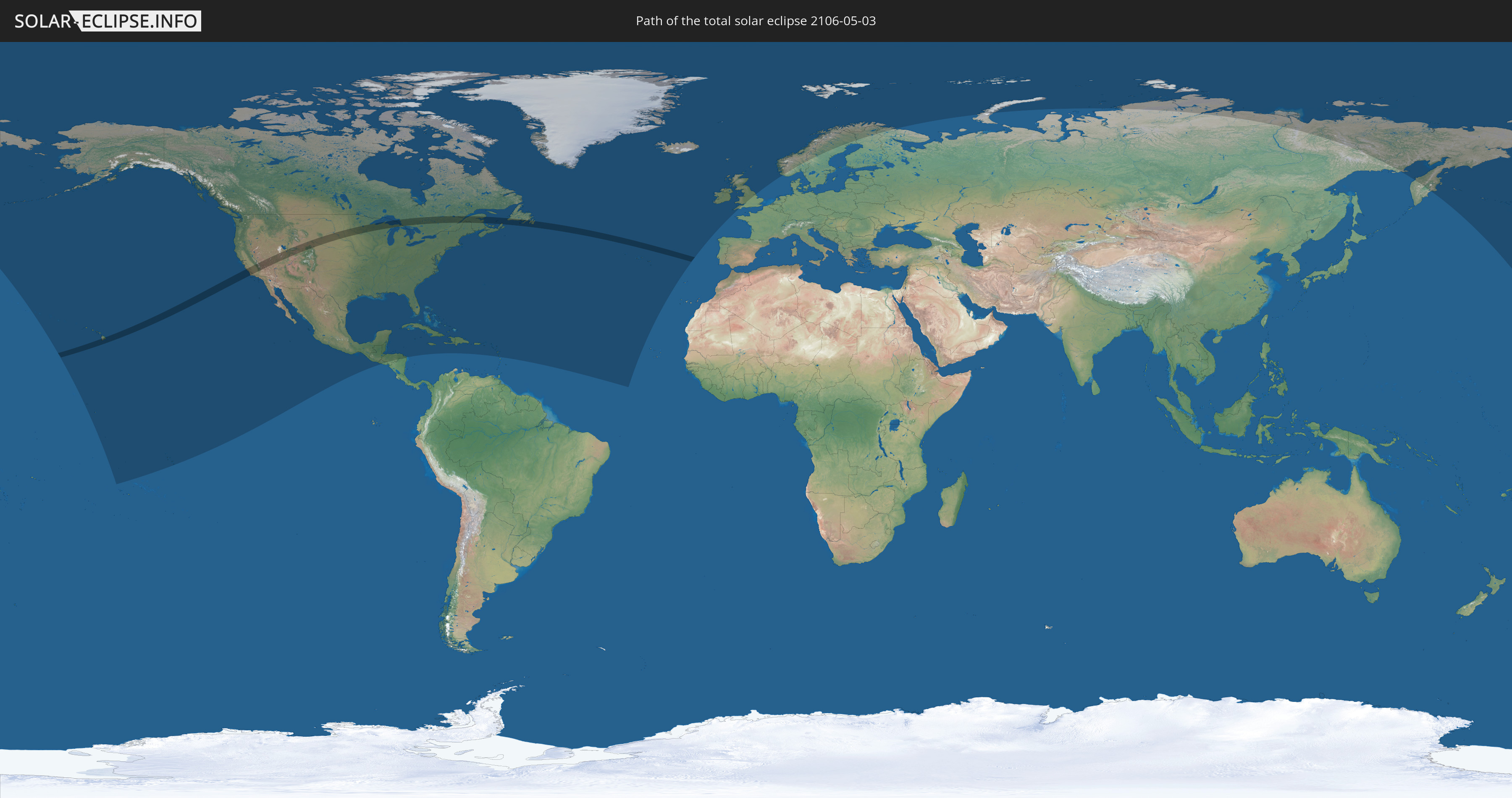
Total solar eclipse of 05/03/2106
| Day of week: | Monday |
| Maximum duration of eclipse: | 03m47s |
| Maximum width of eclipse path: | 177 km |
| Saros cycle: | 130 |
| Coverage: | 100% |
| Magnitude: | 1.0472 |
| Gamma: | 0.4681 |
Wo kann man die Sonnenfinsternis vom 05/03/2106 sehen?
Die Sonnenfinsternis am 05/03/2106 kann man in 43 Ländern als partielle Sonnenfinsternis beobachten.
Der Finsternispfad verläuft durch 3 Länder. Nur in diesen Ländern ist sie als total Sonnenfinsternis zu sehen.
In den folgenden Ländern ist die Sonnenfinsternis total zu sehen
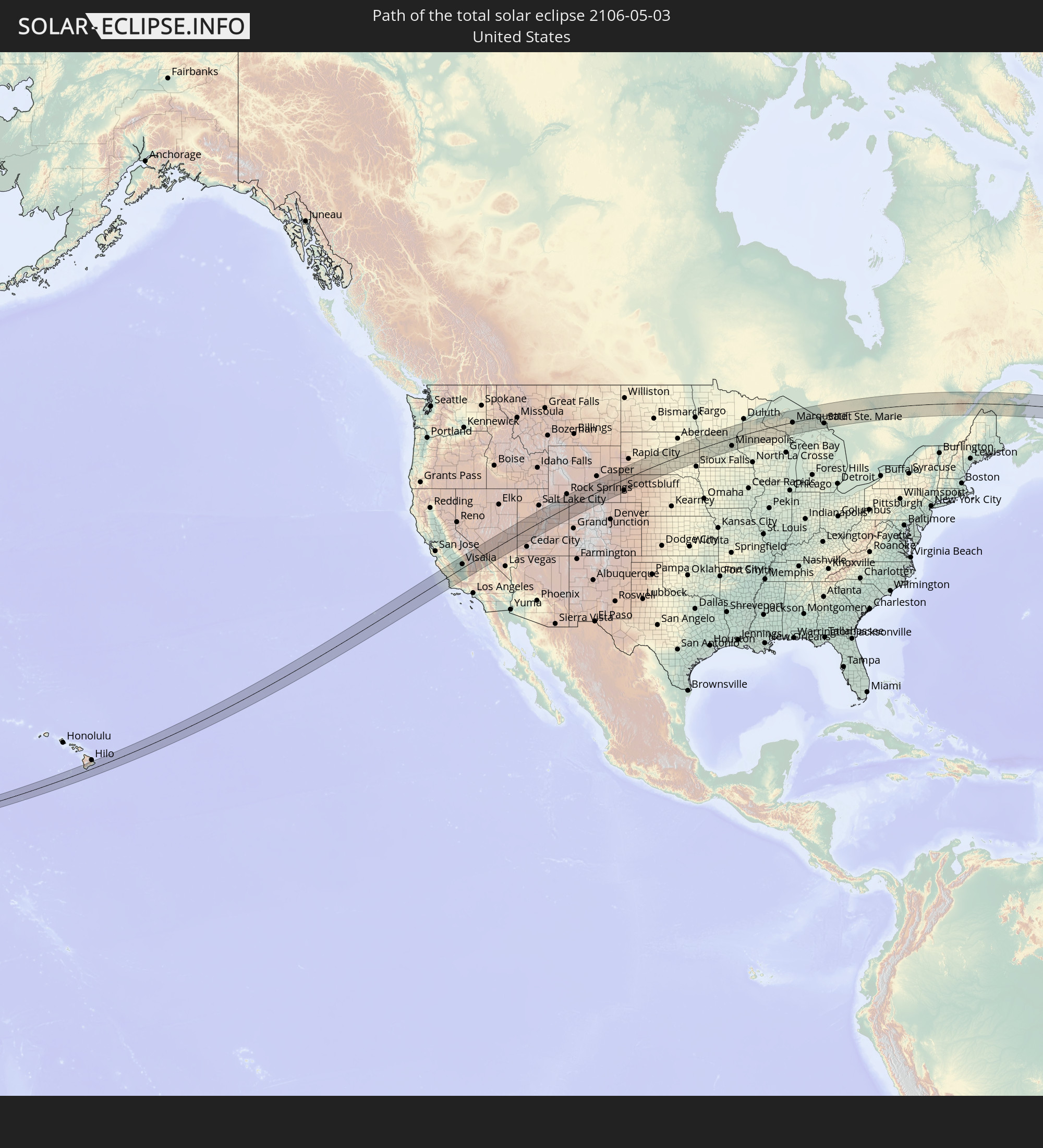 United States
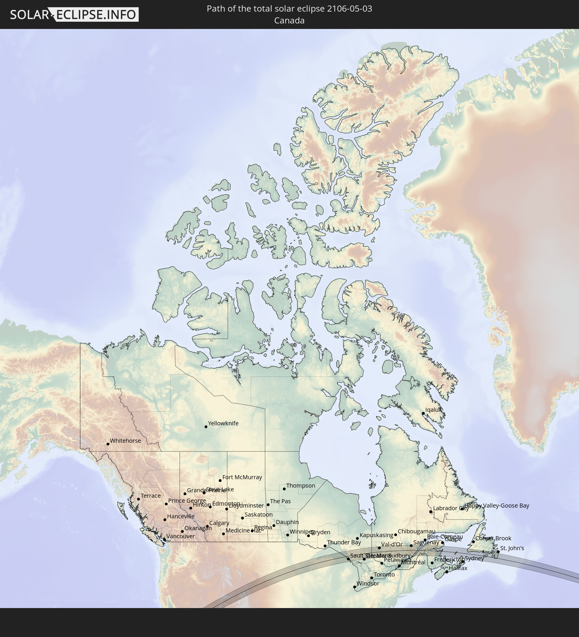 Canada
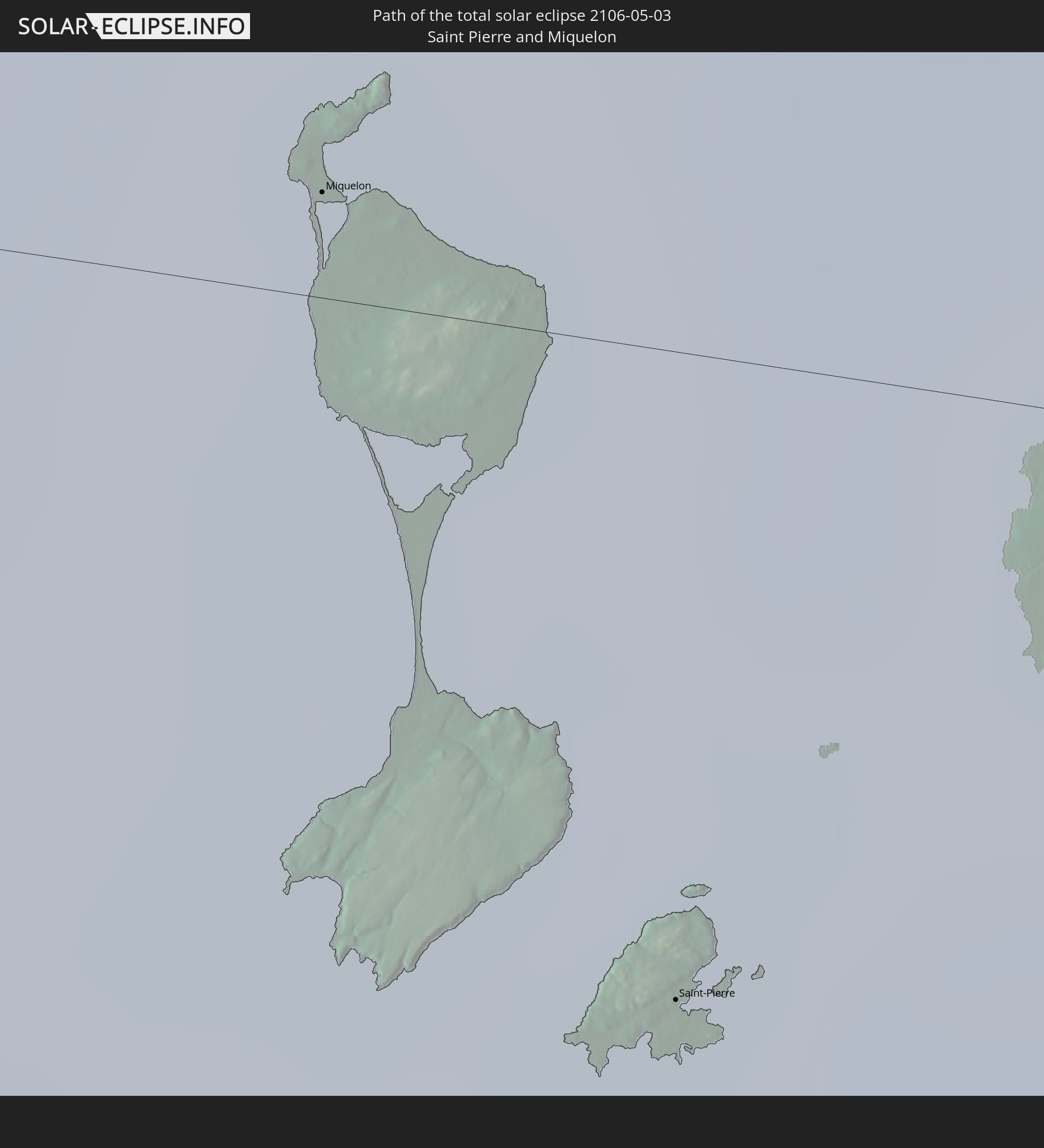 Saint Pierre and Miquelon
In den folgenden Ländern ist die Sonnenfinsternis partiell zu sehen
 Russia
 United States
 United States Minor Outlying Islands
 Kiribati
 French Polynesia
 Canada
 Mexico
 Greenland
 Guatemala
 El Salvador
 Honduras
 Belize
 Nicaragua
 Cuba
Cuba
 Cayman Islands
 The Bahamas
 Jamaica
 Haiti
Haiti
 Turks and Caicos Islands
 Dominican Republic
 Puerto Rico
 United States Virgin Islands
 Bermuda
 British Virgin Islands
 Anguilla
 Collectivity of Saint Martin
 Saint Barthélemy
 Saint Kitts and Nevis
 Antigua and Barbuda
 Montserrat
 Guadeloupe
 Dominica
 Saint Pierre and Miquelon
 Portugal
 Iceland
 Republic of Ireland
 Svalbard and Jan Mayen
 United Kingdom
 Faroe Islands
 Isle of Man
 Norway
 Sweden
 Finland
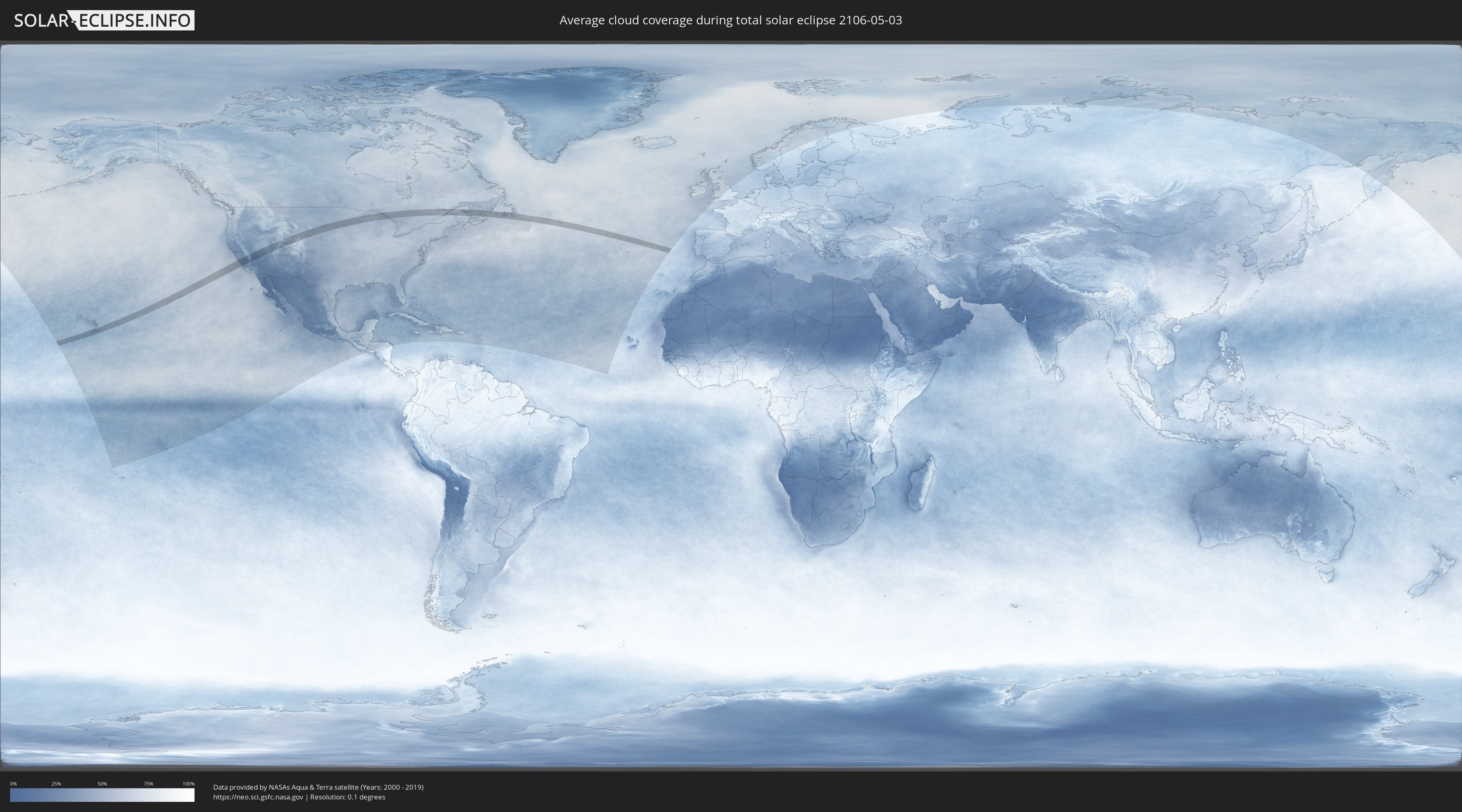
How will be the weather during the total solar eclipse on 05/03/2106?
Where is the best place to see the total solar eclipse of 05/03/2106?
The following maps show the average cloud coverage for the day of the total solar eclipse.
With the help of these maps, it is possible to find the place along the eclipse path, which has the best
chance of a cloudless sky.
Nevertheless, you should consider local circumstances and inform about the weather of your chosen
observation site.
The data is provided by NASAs satellites
AQUA and TERRA.
The cloud maps are averaged over a period of 19 years (2000 - 2019).

Detailed country maps
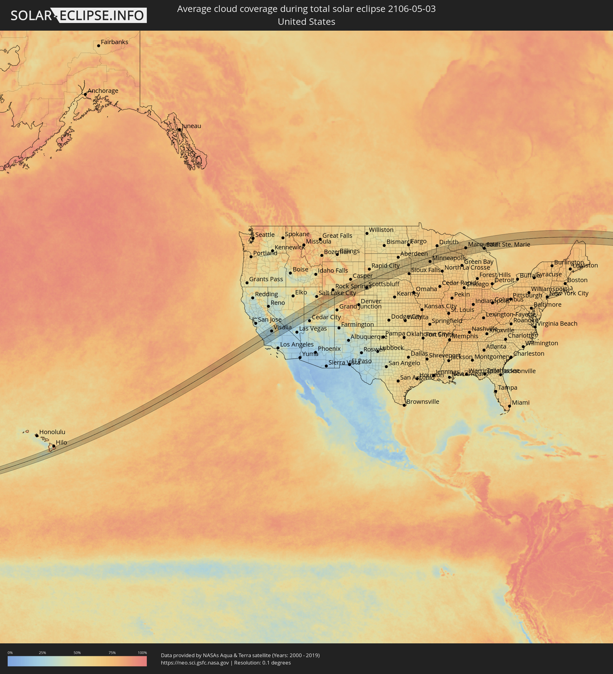 United States
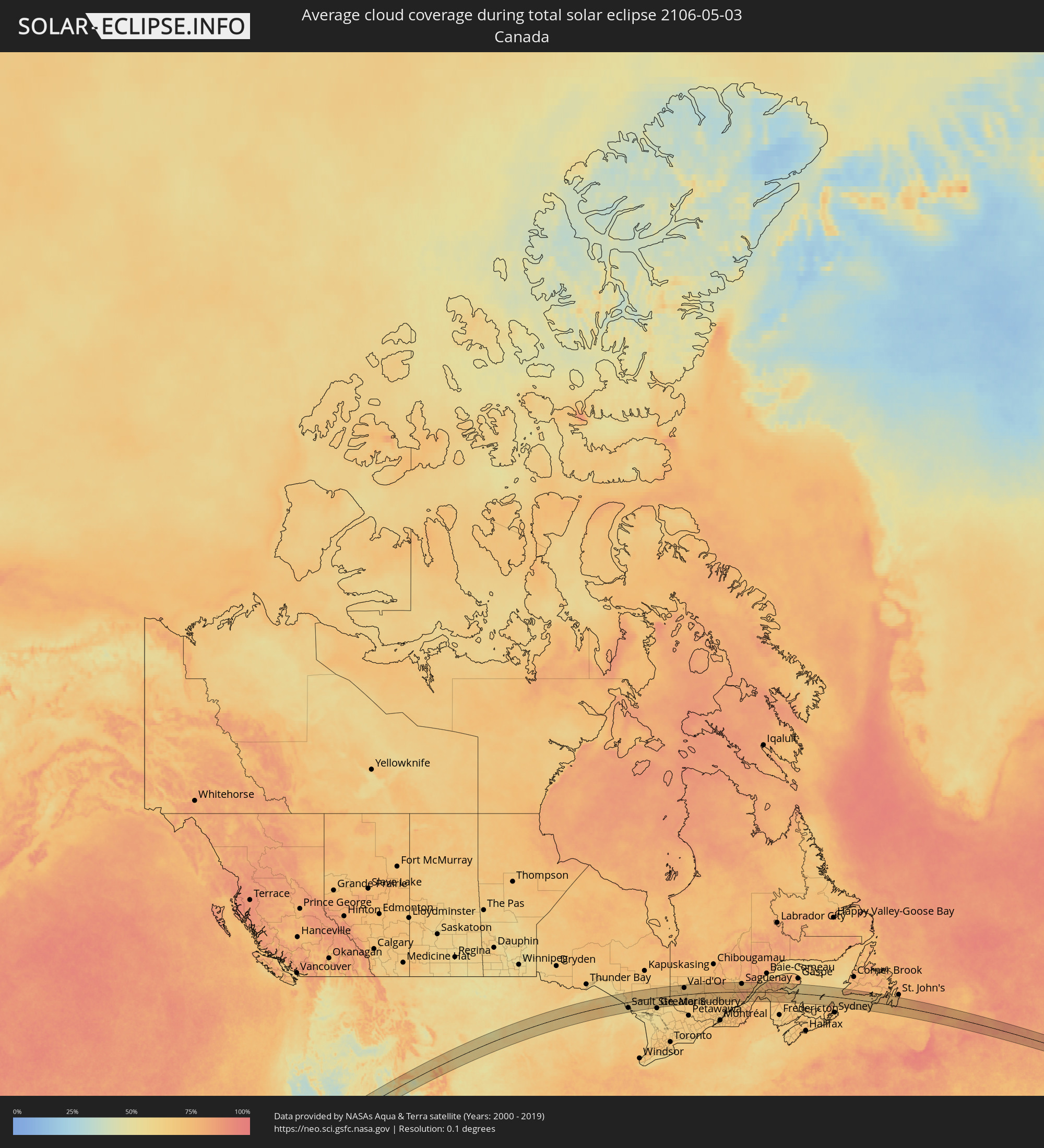 Canada
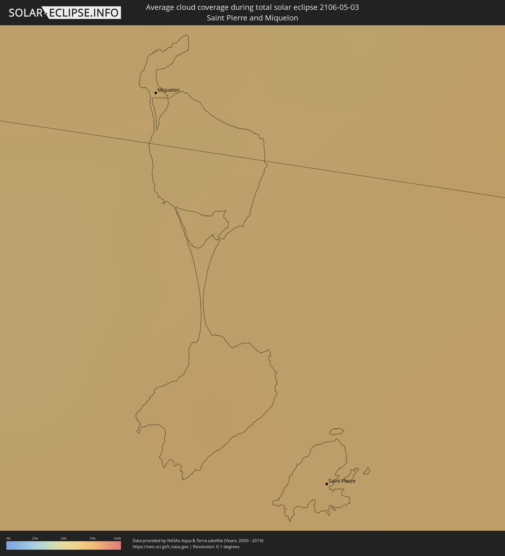 Saint Pierre and Miquelon
Cities inside the path of the eclipse
The following table shows all locations with a population of more than 5,000 inside the eclipse path. Cities which have more than 100,000 inhabitants are marked bold. A click at the locations opens a detailed map.
| City | Type | Eclipse duration | Local time of max. eclipse | Distance to central line | Ø Cloud coverage |
|
Hawaiian Paradise Park, Hawaii
|
total | - | 06:45:55 UTC-10:00 | 61 km | 81% |
|
Los Osos, California
|
total | - | 09:33:43 UTC-08:00 | 3 km | 34% |
|
Paso Robles, California
|
total | - | 09:34:26 UTC-08:00 | 26 km | 26% |
|
Atascadero, California
|
total | - | 09:34:14 UTC-08:00 | 12 km | 28% |
|
San Luis Obispo, California
|
total | - | 09:33:55 UTC-08:00 | 8 km | 30% |
|
Arroyo Grande, California
|
total | - | 09:33:45 UTC-08:00 | 27 km | 40% |
|
Lompoc, California
|
total | - | 09:33:09 UTC-08:00 | 79 km | 37% |
|
Santa Maria, California
|
total | - | 09:33:42 UTC-08:00 | 50 km | 31% |
|
Coalinga, California
|
total | - | 09:35:45 UTC-08:00 | 59 km | 28% |
|
Avenal, California
|
total | - | 09:35:51 UTC-08:00 | 35 km | 25% |
|
Fresno, California
|
total | - | 09:37:35 UTC-08:00 | 89 km | 27% |
|
Hanford, California
|
total | - | 09:37:05 UTC-08:00 | 43 km | 26% |
|
Corcoran, California
|
total | - | 09:36:50 UTC-08:00 | 17 km | 25% |
|
Sanger, California
|
total | - | 09:37:50 UTC-08:00 | 75 km | 30% |
|
Taft, California
|
total | - | 09:35:26 UTC-08:00 | 79 km | 27% |
|
Reedley, California
|
total | - | 09:37:48 UTC-08:00 | 59 km | 29% |
|
Wasco, California
|
total | - | 09:36:20 UTC-08:00 | 41 km | 27% |
|
Visalia, California
|
total | - | 09:37:36 UTC-08:00 | 26 km | 29% |
|
Orosi, California
|
total | - | 09:37:57 UTC-08:00 | 46 km | 29% |
|
Earlimart, California
|
total | - | 09:36:54 UTC-08:00 | 17 km | 27% |
|
Delano, California
|
total | - | 09:36:45 UTC-08:00 | 29 km | 27% |
|
Lindsay, California
|
total | - | 09:37:42 UTC-08:00 | 5 km | 31% |
|
Bakersfield, California
|
total | - | 09:36:27 UTC-08:00 | 77 km | 28% |
|
Porterville, California
|
total | - | 09:37:35 UTC-08:00 | 12 km | 32% |
|
Eagle Mountain, Utah
|
total | - | 10:55:11 UTC-07:00 | 84 km | 55% |
|
Lehi, Utah
|
total | - | 10:55:33 UTC-07:00 | 85 km | 52% |
|
Payson, Utah
|
total | - | 10:55:15 UTC-07:00 | 46 km | 64% |
|
Provo, Utah
|
total | - | 10:55:39 UTC-07:00 | 62 km | 45% |
|
Heber City, Utah
|
total | - | 10:56:27 UTC-07:00 | 78 km | 59% |
|
Price, Utah
|
total | - | 10:56:12 UTC-07:00 | 35 km | 50% |
|
Vernal, Utah
|
total | - | 10:59:35 UTC-07:00 | 3 km | 49% |
|
Craig, Colorado
|
total | - | 11:03:10 UTC-07:00 | 74 km | 62% |
|
Rawlins, Wyoming
|
total | - | 11:05:19 UTC-07:00 | 41 km | 60% |
|
Laramie, Wyoming
|
total | - | 11:07:42 UTC-07:00 | 68 km | 65% |
|
Scottsbluff, Nebraska
|
total | - | 11:11:51 UTC-07:00 | 80 km | 51% |
|
Gering, Nebraska
|
total | - | 11:11:50 UTC-07:00 | 84 km | 54% |
|
Alliance, Nebraska
|
total | - | 11:13:35 UTC-07:00 | 83 km | 56% |
|
Pierre, South Dakota
|
total | - | 12:20:22 UTC-06:00 | 69 km | 48% |
|
Huron, South Dakota
|
total | - | 12:24:14 UTC-06:00 | 6 km | 55% |
|
Mitchell, South Dakota
|
total | - | 12:24:04 UTC-06:00 | 67 km | 60% |
|
Watertown, South Dakota
|
total | - | 12:26:38 UTC-06:00 | 32 km | 57% |
|
Brookings, South Dakota
|
total | - | 12:26:48 UTC-06:00 | 38 km | 58% |
|
Marshall, Minnesota
|
total | - | 12:28:45 UTC-06:00 | 50 km | 60% |
|
Willmar, Minnesota
|
total | - | 12:30:31 UTC-06:00 | 2 km | 57% |
|
Hutchinson, Minnesota
|
total | - | 12:31:37 UTC-06:00 | 39 km | 57% |
|
Saint Cloud, Minnesota
|
total | - | 12:32:21 UTC-06:00 | 27 km | 58% |
|
Buffalo, Minnesota
|
total | - | 12:32:40 UTC-06:00 | 21 km | 59% |
|
Monticello, Minnesota
|
total | - | 12:32:53 UTC-06:00 | 9 km | 60% |
|
Waconia, Minnesota
|
total | - | 12:32:40 UTC-06:00 | 57 km | 61% |
|
Elk River, Minnesota
|
total | - | 12:33:18 UTC-06:00 | 14 km | 61% |
|
Rogers, Minnesota
|
total | - | 12:33:16 UTC-06:00 | 27 km | 59% |
|
Shakopee, Minnesota
|
total | - | 12:33:07 UTC-06:00 | 69 km | 61% |
|
Plymouth, Minnesota
|
total | - | 12:33:21 UTC-06:00 | 48 km | 62% |
|
West Coon Rapids, Minnesota
|
total | - | 12:33:37 UTC-06:00 | 34 km | 62% |
|
Bloomington, Minnesota
|
total | - | 12:33:33 UTC-06:00 | 70 km | 61% |
|
Minneapolis, Minnesota
|
total | - | 12:33:41 UTC-06:00 | 56 km | 61% |
|
East Bethel, Minnesota
|
total | - | 12:33:58 UTC-06:00 | 21 km | 61% |
|
Rosemount, Minnesota
|
total | - | 12:33:49 UTC-06:00 | 84 km | 60% |
|
White Bear Lake, Minnesota
|
total | - | 12:34:12 UTC-06:00 | 50 km | 60% |
|
Forest Lake, Minnesota
|
total | - | 12:34:20 UTC-06:00 | 30 km | 59% |
|
North Branch, Minnesota
|
total | - | 12:34:27 UTC-06:00 | 5 km | 62% |
|
Woodbury, Minnesota
|
total | - | 12:34:13 UTC-06:00 | 68 km | 60% |
|
Stillwater, Minnesota
|
total | - | 12:34:34 UTC-06:00 | 58 km | 61% |
|
River Falls, Wisconsin
|
total | - | 12:34:48 UTC-06:00 | 83 km | 60% |
|
Rice Lake, Wisconsin
|
total | - | 12:36:41 UTC-06:00 | 33 km | 60% |
|
Marquette, Michigan
|
total | - | 13:44:38 UTC-05:00 | 3 km | 67% |
|
Sault Ste. Marie, Michigan
|
total | - | 13:49:50 UTC-05:00 | 54 km | 58% |
|
Sault Ste. Marie, Ontario
|
total | - | 13:49:51 UTC-05:00 | 52 km | 58% |
|
Rayside-Balfour, Ontario
|
total | - | 13:55:03 UTC-05:00 | 79 km | 61% |
|
Kirkland Lake, Ontario
|
total | - | 13:56:33 UTC-05:00 | 80 km | 69% |
|
Temiskaming Shores, Ontario
|
total | - | 13:57:14 UTC-05:00 | 5 km | 65% |
|
Rouyn-Noranda, Quebec
|
total | - | 13:58:04 UTC-05:00 | 81 km | 68% |
|
Val-d'Or, Quebec
|
total | - | 13:59:58 UTC-05:00 | 57 km | 67% |
|
La Tuque, Quebec
|
total | - | 14:07:35 UTC-05:00 | 39 km | 71% |
|
Roberval, Quebec
|
total | - | 14:07:41 UTC-05:00 | 81 km | 74% |
|
Alma, Quebec
|
total | - | 14:08:26 UTC-05:00 | 84 km | 68% |
|
Jonquière, Quebec
|
total | - | 14:09:03 UTC-05:00 | 69 km | 69% |
|
Saguenay, Quebec
|
total | - | 14:09:18 UTC-05:00 | 68 km | 69% |
|
Baie-Saint-Paul, Quebec
|
total | - | 14:10:42 UTC-05:00 | 40 km | 71% |
|
La Malbaie, Quebec
|
total | - | 14:11:01 UTC-05:00 | 17 km | 70% |
|
Rivière-du-Loup, Quebec
|
total | - | 14:11:42 UTC-05:00 | 3 km | 64% |
|
Rimouski, Quebec
|
total | - | 14:12:32 UTC-05:00 | 74 km | 68% |
|
Edmundston, New Brunswick
|
total | - | 15:13:36 UTC-04:00 | 46 km | 70% |
|
Amqui, Quebec
|
total | - | 14:13:52 UTC-05:00 | 78 km | 81% |
|
Campbellton, New Brunswick
|
total | - | 15:15:09 UTC-04:00 | 29 km | 77% |
|
Bathurst, New Brunswick
|
total | - | 15:16:42 UTC-04:00 | 10 km | 67% |
|
Miramichi, New Brunswick
|
total | - | 15:17:22 UTC-04:00 | 75 km | 66% |
|
Chandler, Quebec
|
total | - | 14:17:12 UTC-05:00 | 75 km | 63% |
|
Miquelon, Miquelon-Langlade
|
total | - | 16:26:54 UTC-03:00 | 5 km | 64% |
|
Saint-Pierre, Saint-Pierre
|
total | - | 16:27:25 UTC-03:00 | 28 km | 69% |