Annular solar eclipse of 10/09/2219
| Day of week: | Saturday |
| Maximum duration of eclipse: | 08m46s |
| Maximum width of eclipse path: | 248 km |
| Saros cycle: | 147 |
| Coverage: | 93.4% |
| Magnitude: | 0.9338 |
| Gamma: | 0.0744 |
Wo kann man die Sonnenfinsternis vom 10/09/2219 sehen?
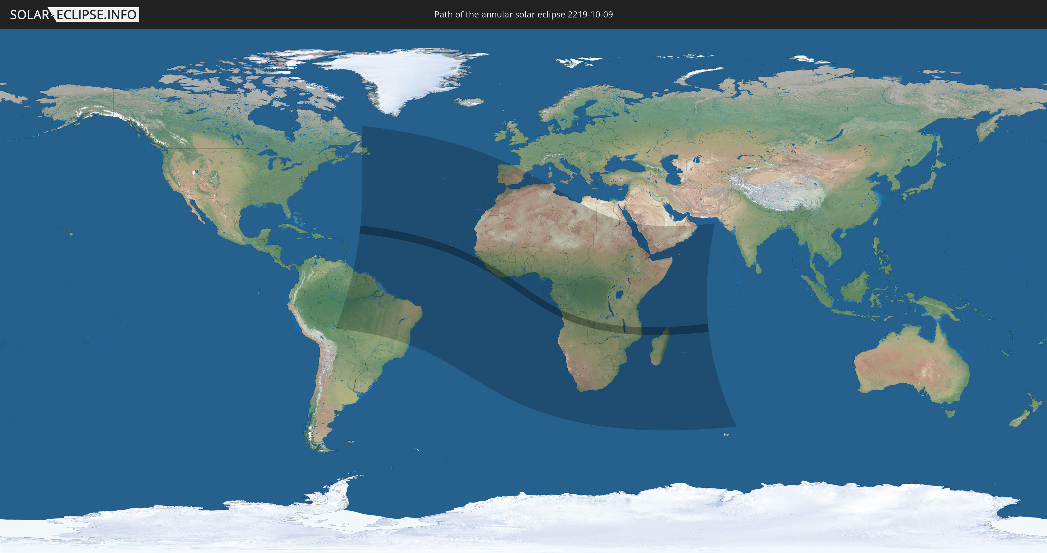
Die Sonnenfinsternis am 10/09/2219 kann man in 69 Ländern als partielle Sonnenfinsternis beobachten.
Der Finsternispfad verläuft durch 13 Länder. Nur in diesen Ländern ist sie als annular Sonnenfinsternis zu sehen.
In den folgenden Ländern ist die Sonnenfinsternis annular zu sehen
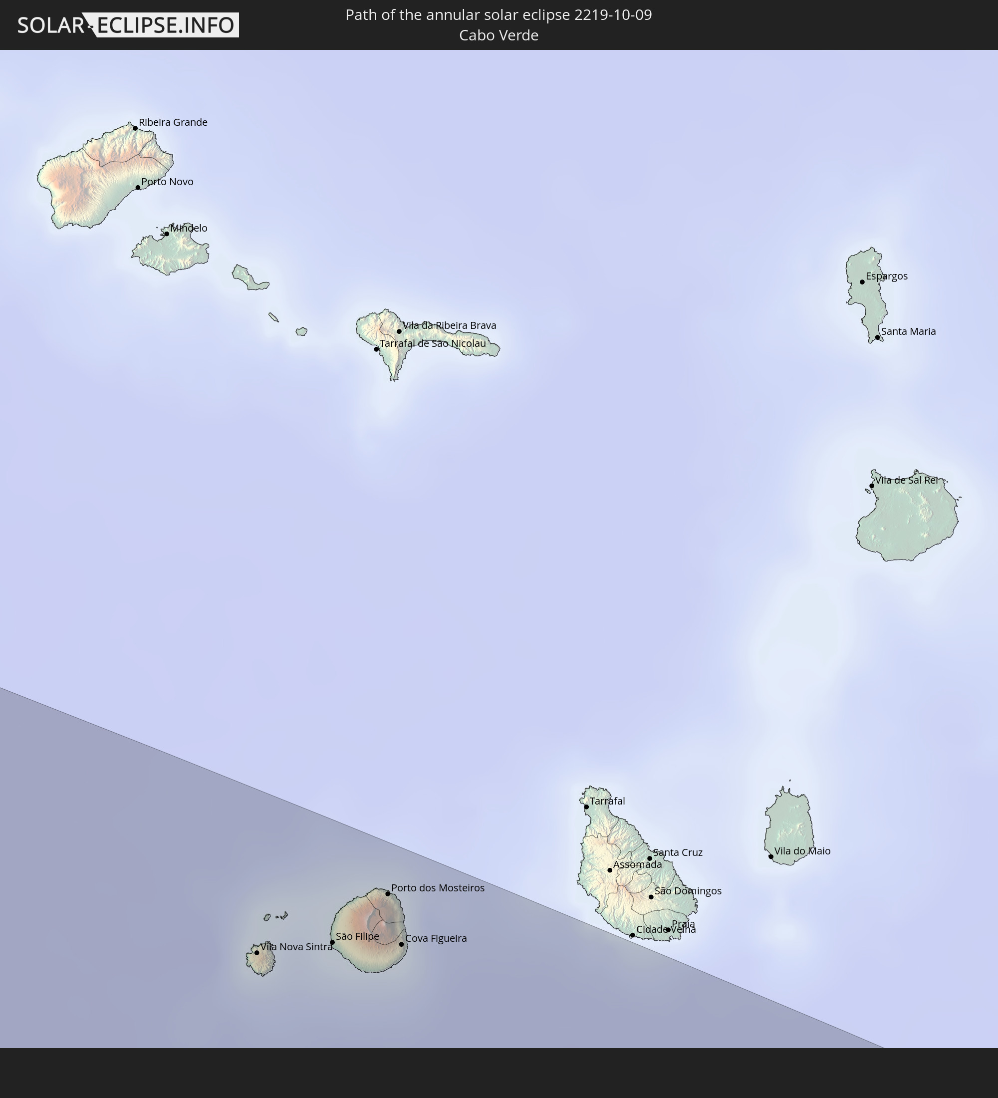 Cabo Verde
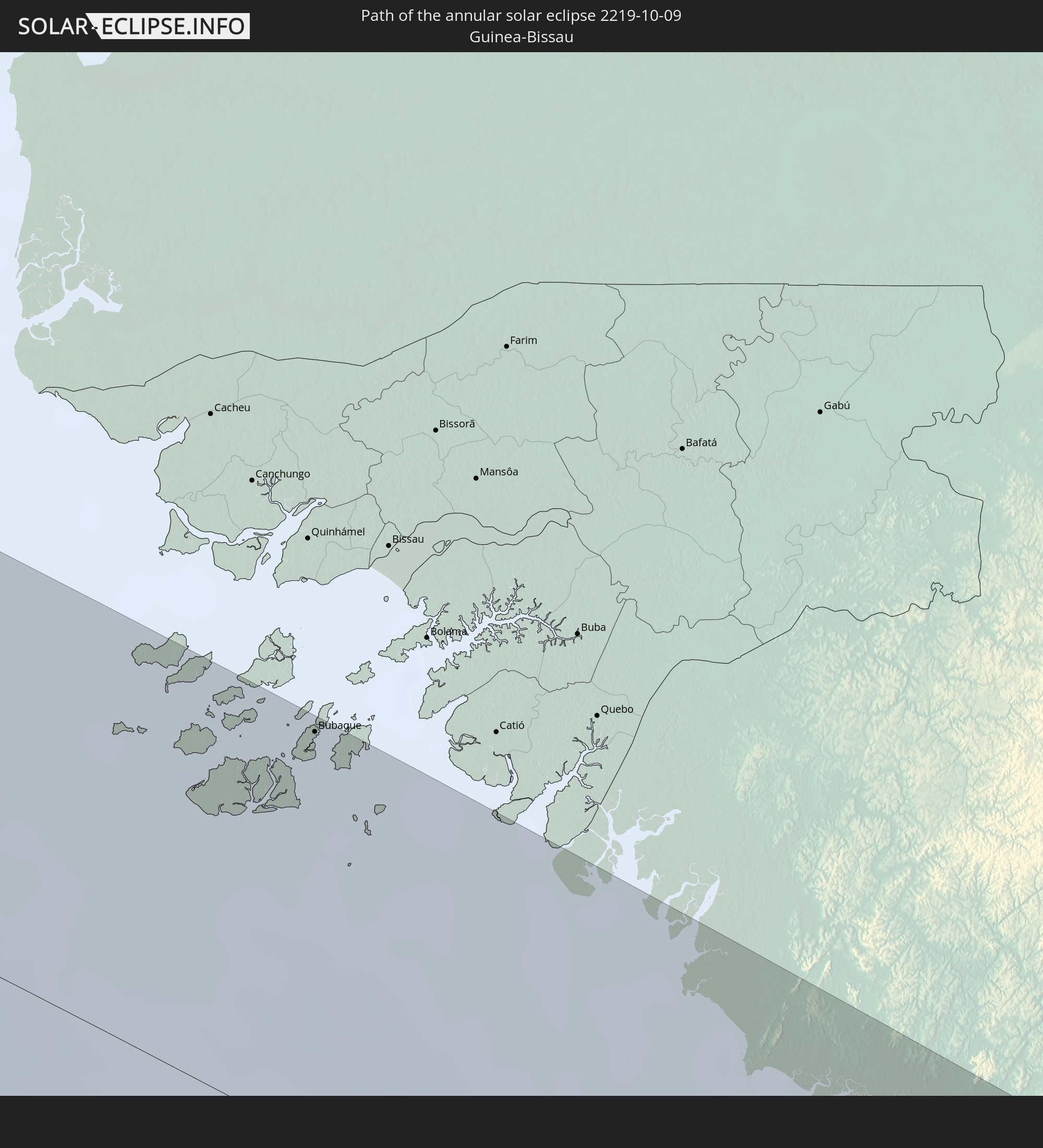 Guinea-Bissau
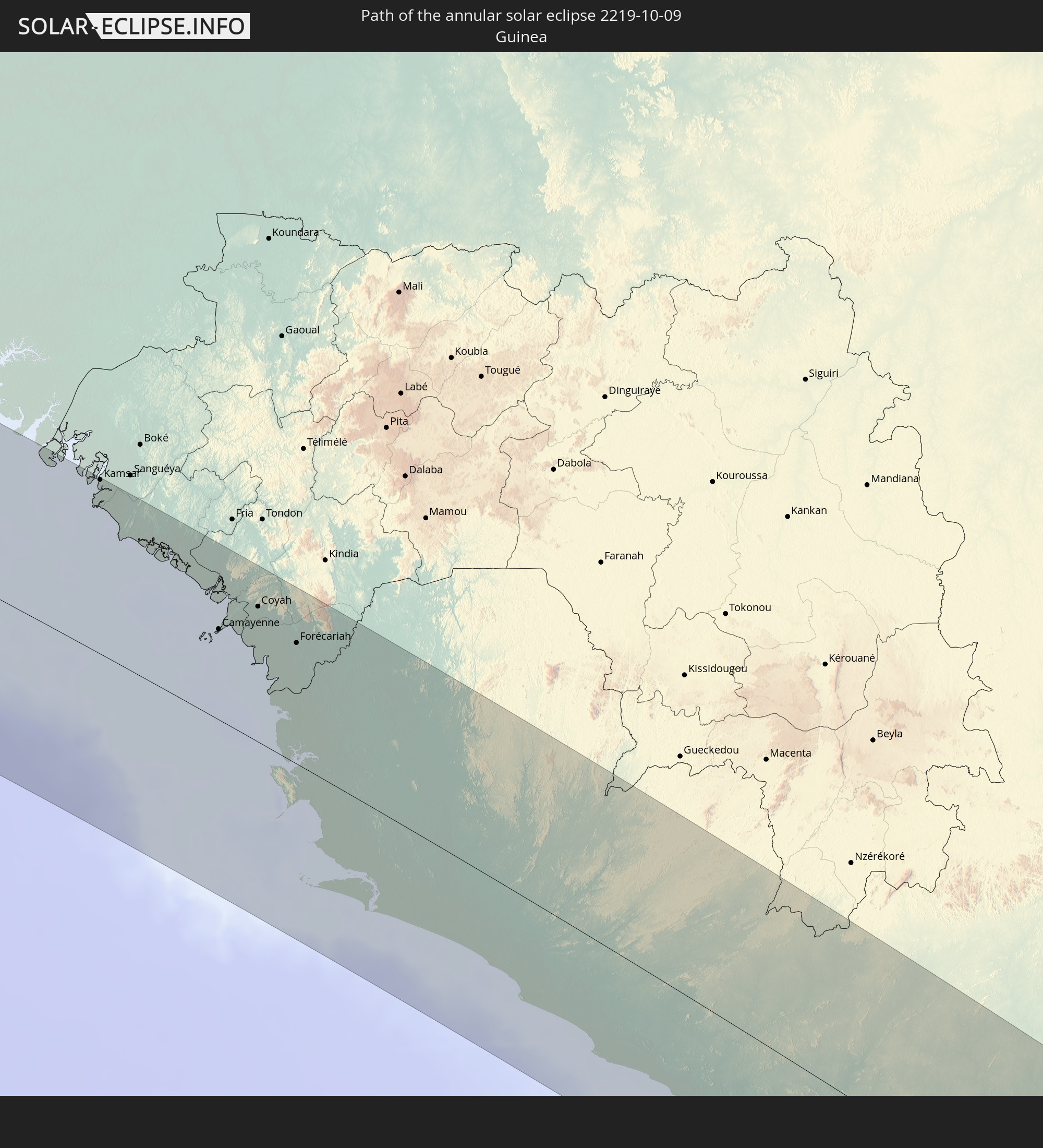 Guinea
 Sierra Leone
 Liberia
 Ivory Coast
 Angola
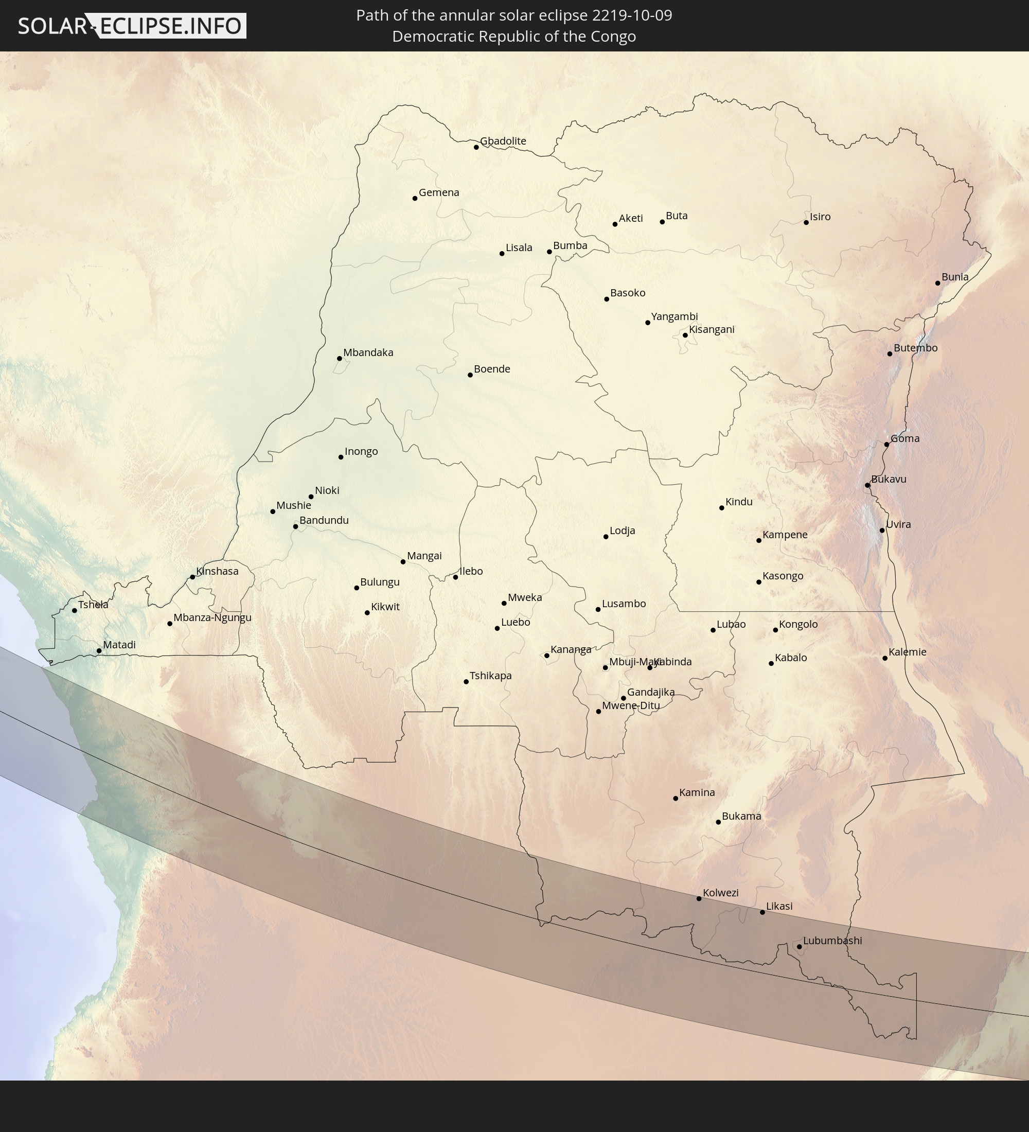 Democratic Republic of the Congo
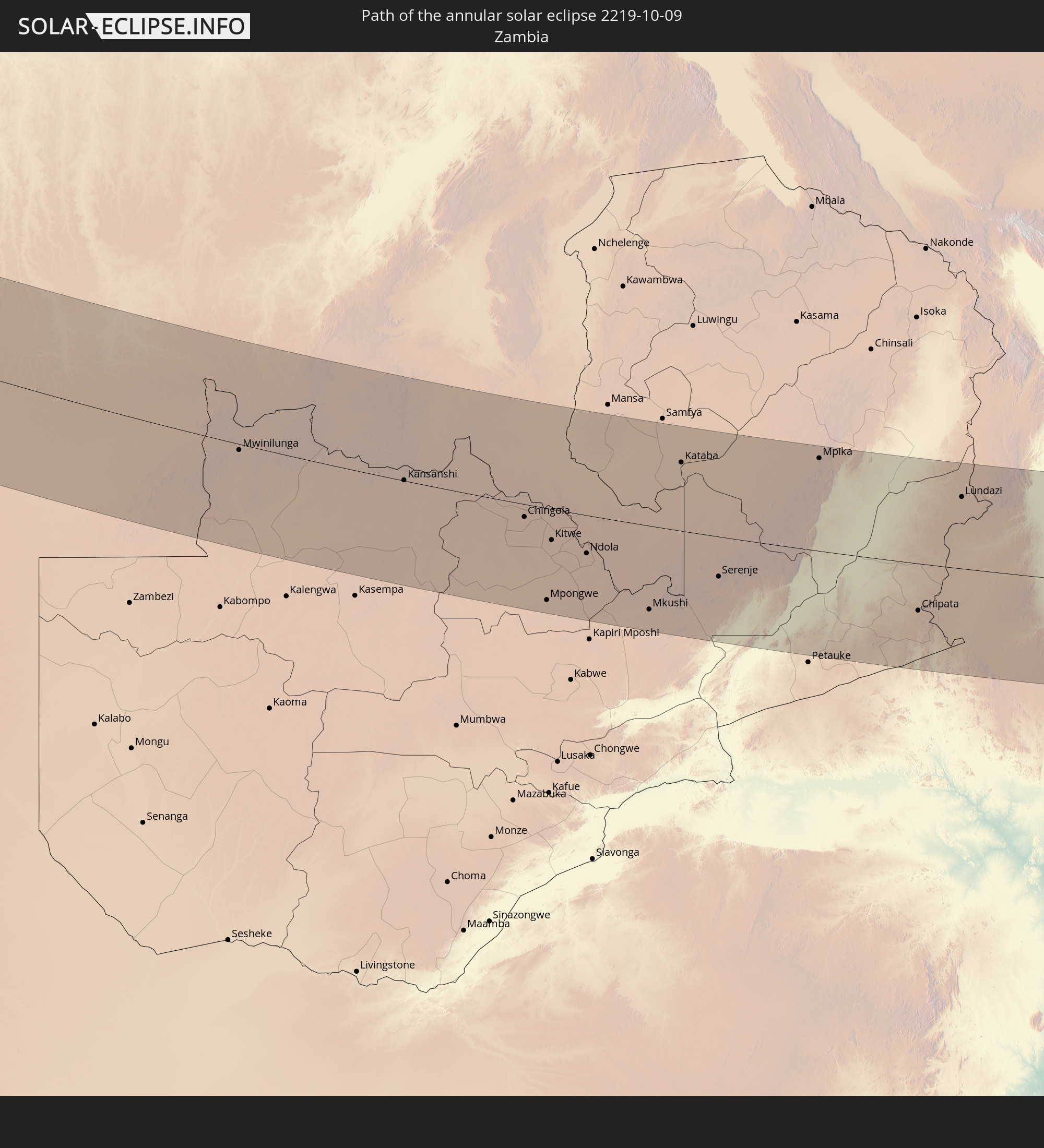 Zambia
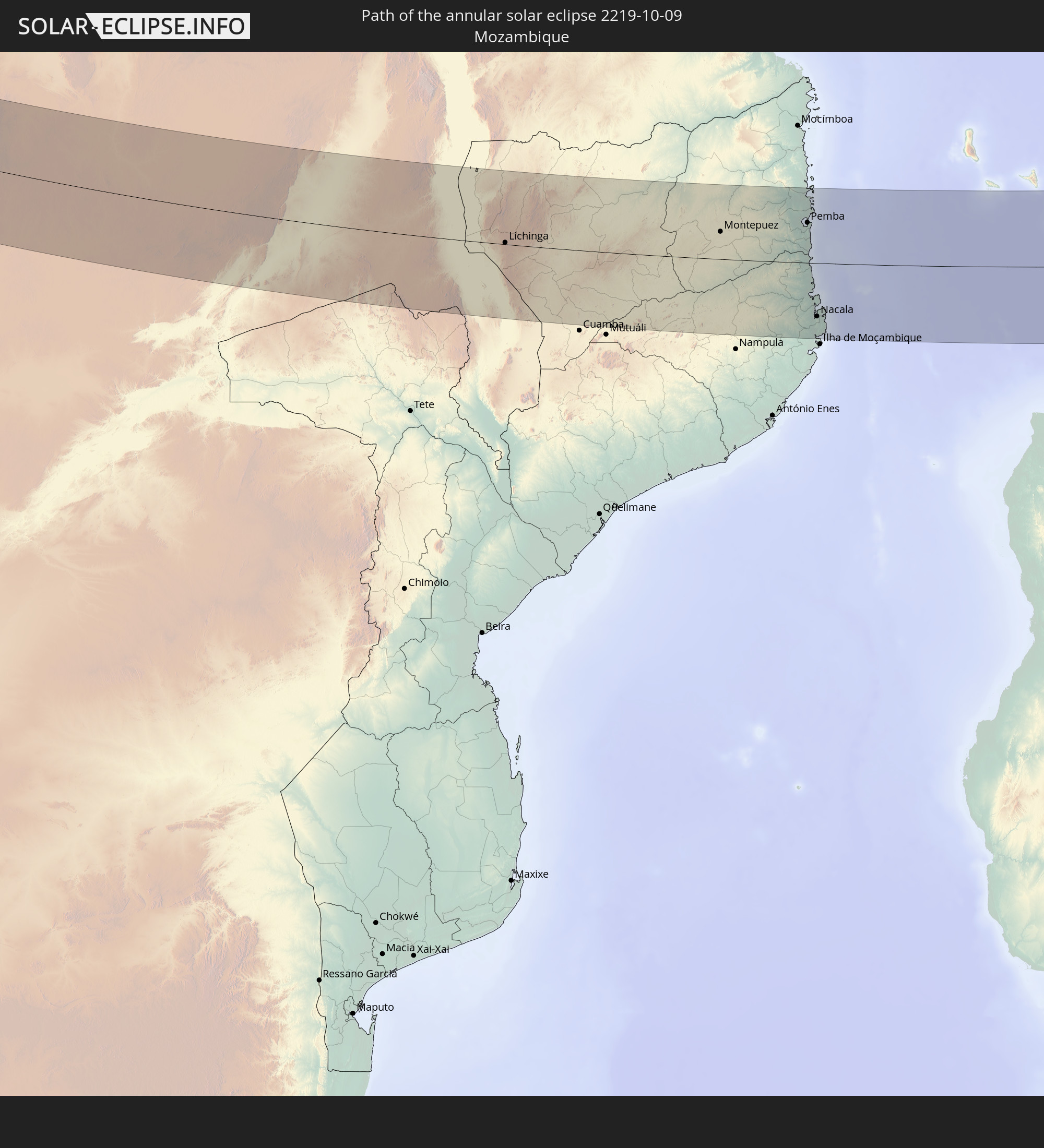 Mozambique
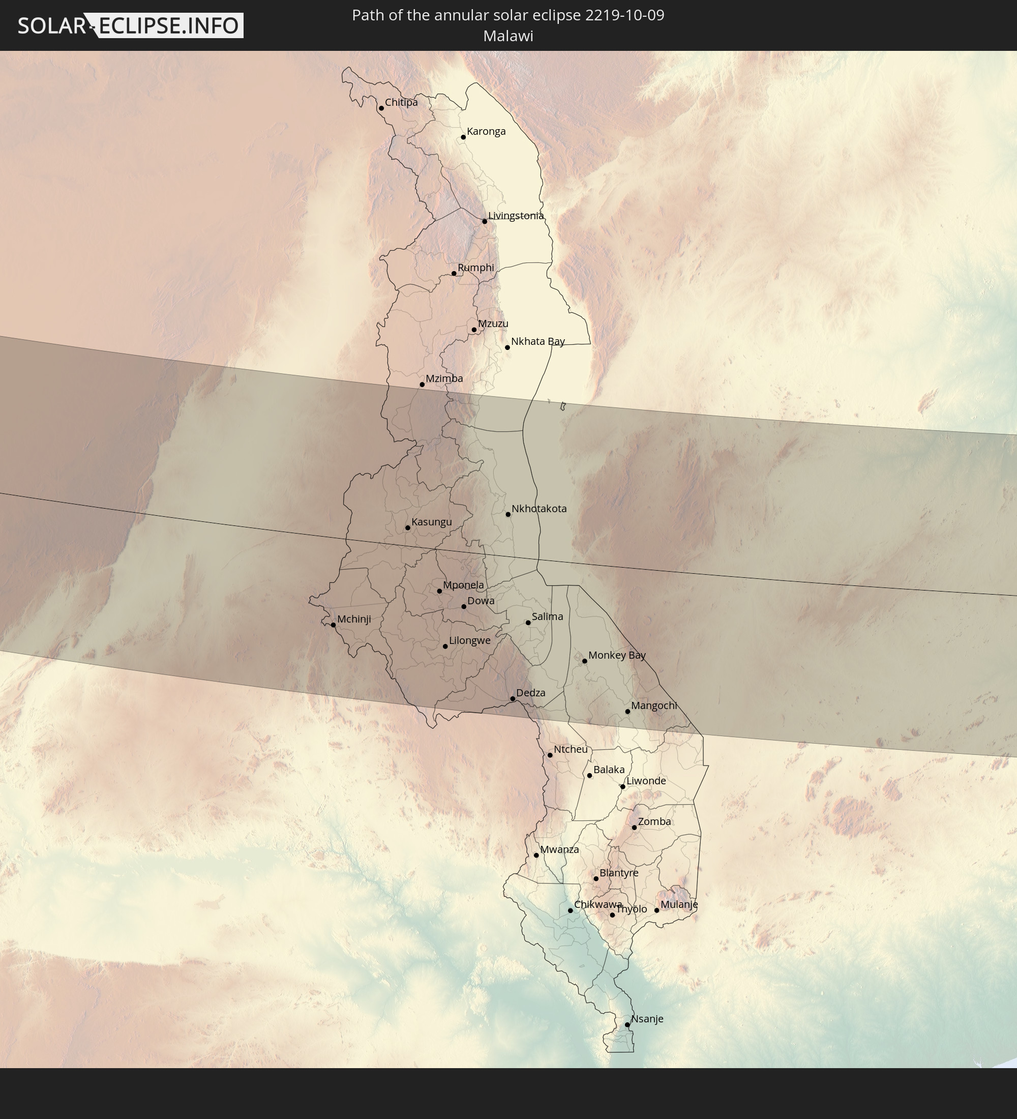 Malawi
 Madagascar
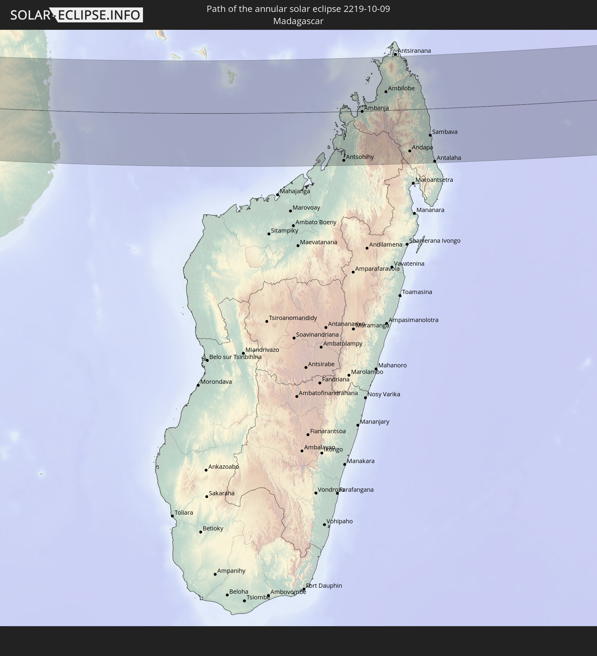
 Mayotte
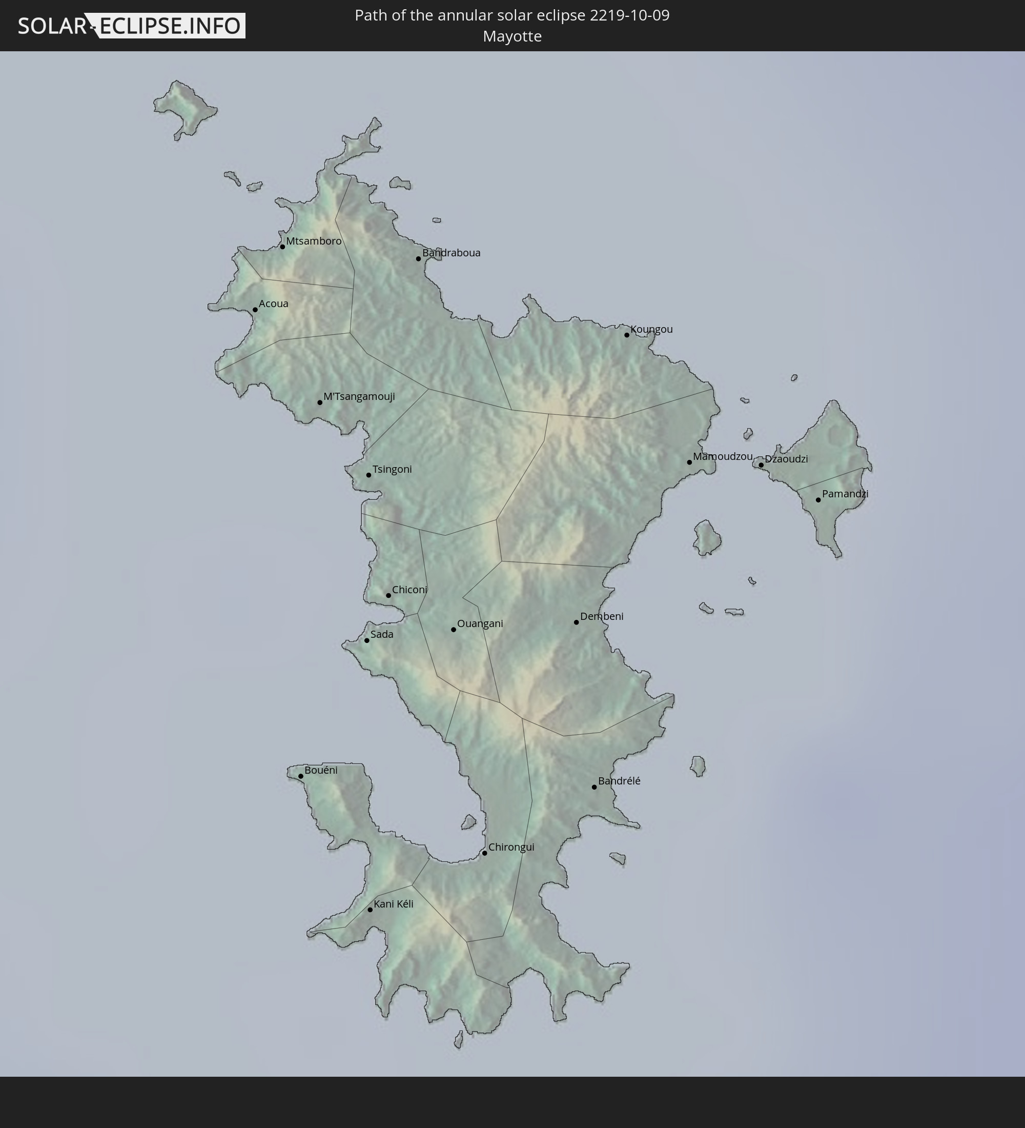
In den folgenden Ländern ist die Sonnenfinsternis partiell zu sehen
 Canada
 Brazil
 Bolivia
 Guyana
 Suriname
 French Guiana
 Portugal
 Cabo Verde
 Spain
Spain
 Senegal
 Mauritania
 The Gambia
 Guinea-Bissau
 Guinea
 Saint Helena, Ascension and Tristan da Cunha
 Sierra Leone
 Morocco
 Mali
Mali
 Liberia
 Algeria
 Ivory Coast
 Burkina Faso
 Gibraltar
 Ghana
Ghana
 Togo
Togo
 Niger
Niger
 Benin
Benin
 Nigeria
 Equatorial Guinea
 São Tomé and Príncipe
 Tunisia
 Cameroon
 Gabon
Gabon
 Libya
Libya
 Republic of the Congo
 Angola
 Namibia
 Democratic Republic of the Congo
 Chad
Chad
 Central African Republic
 South Africa
 Botswana
 Sudan
Sudan
 Zambia
 Egypt
Egypt
 Zimbabwe
 Lesotho
 Rwanda
 Burundi
 Tanzania
 Uganda
 Mozambique
 Swaziland
 Malawi
 Ethiopia
 Kenya
Kenya
 Saudi Arabia
 Eritrea
 French Southern and Antarctic Lands
 Somalia
 Djibouti
 Yemen
Yemen
 Madagascar
 Comoros
 Mayotte
 Seychelles
 Oman
Oman
 Réunion
 Mauritius
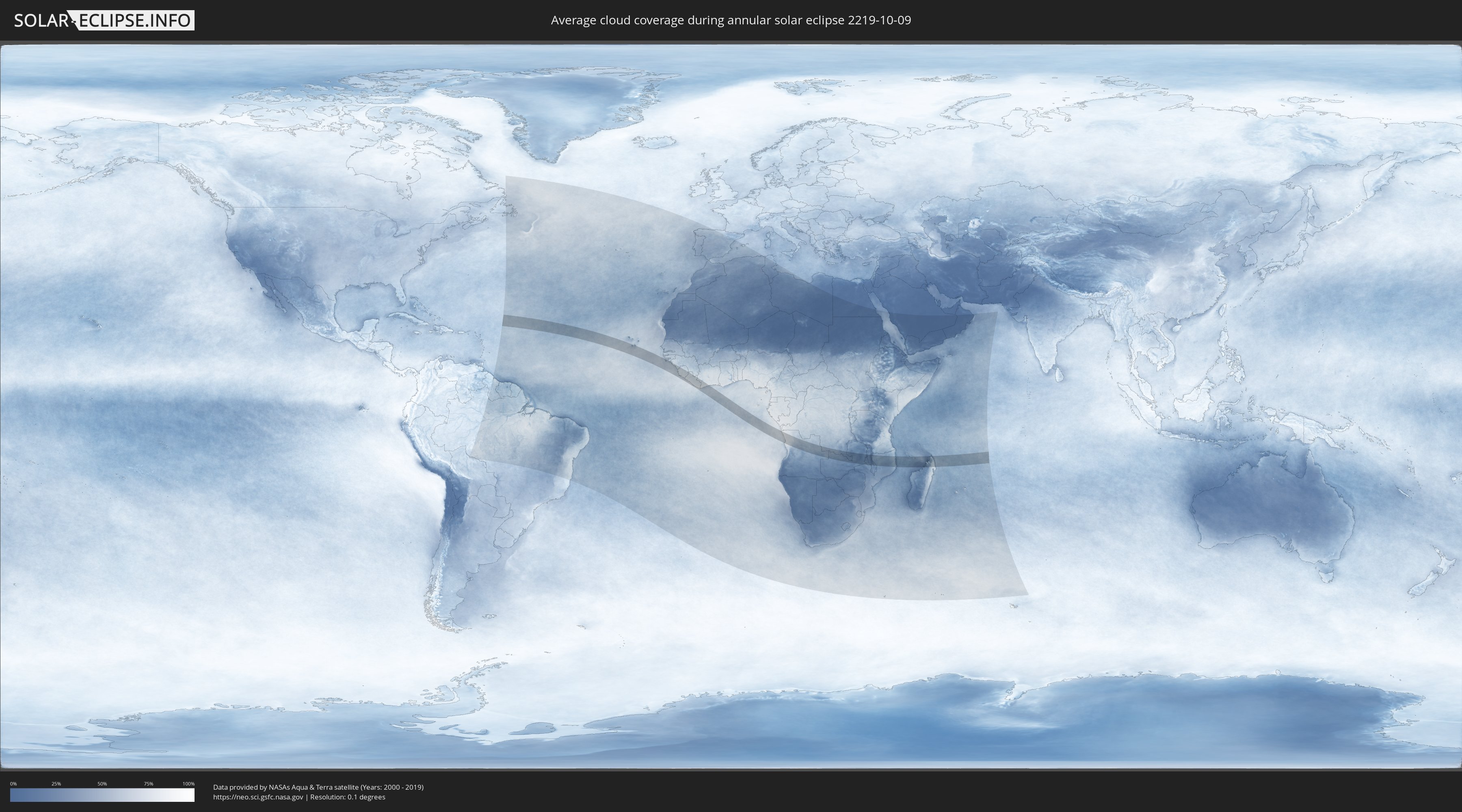
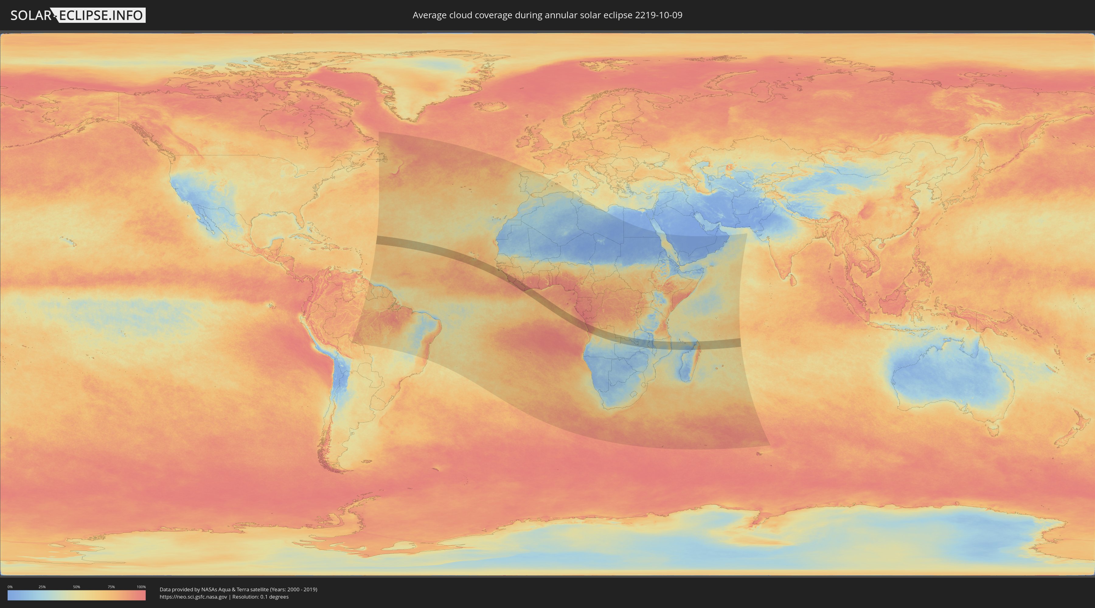
How will be the weather during the annular solar eclipse on 10/09/2219?
Where is the best place to see the annular solar eclipse of 10/09/2219?
The following maps show the average cloud coverage for the day of the annular solar eclipse.
With the help of these maps, it is possible to find the place along the eclipse path, which has the best
chance of a cloudless sky.
Nevertheless, you should consider local circumstances and inform about the weather of your chosen
observation site.
The data is provided by NASAs satellites
AQUA and TERRA.
The cloud maps are averaged over a period of 19 years (2000 - 2019).
Detailed country maps
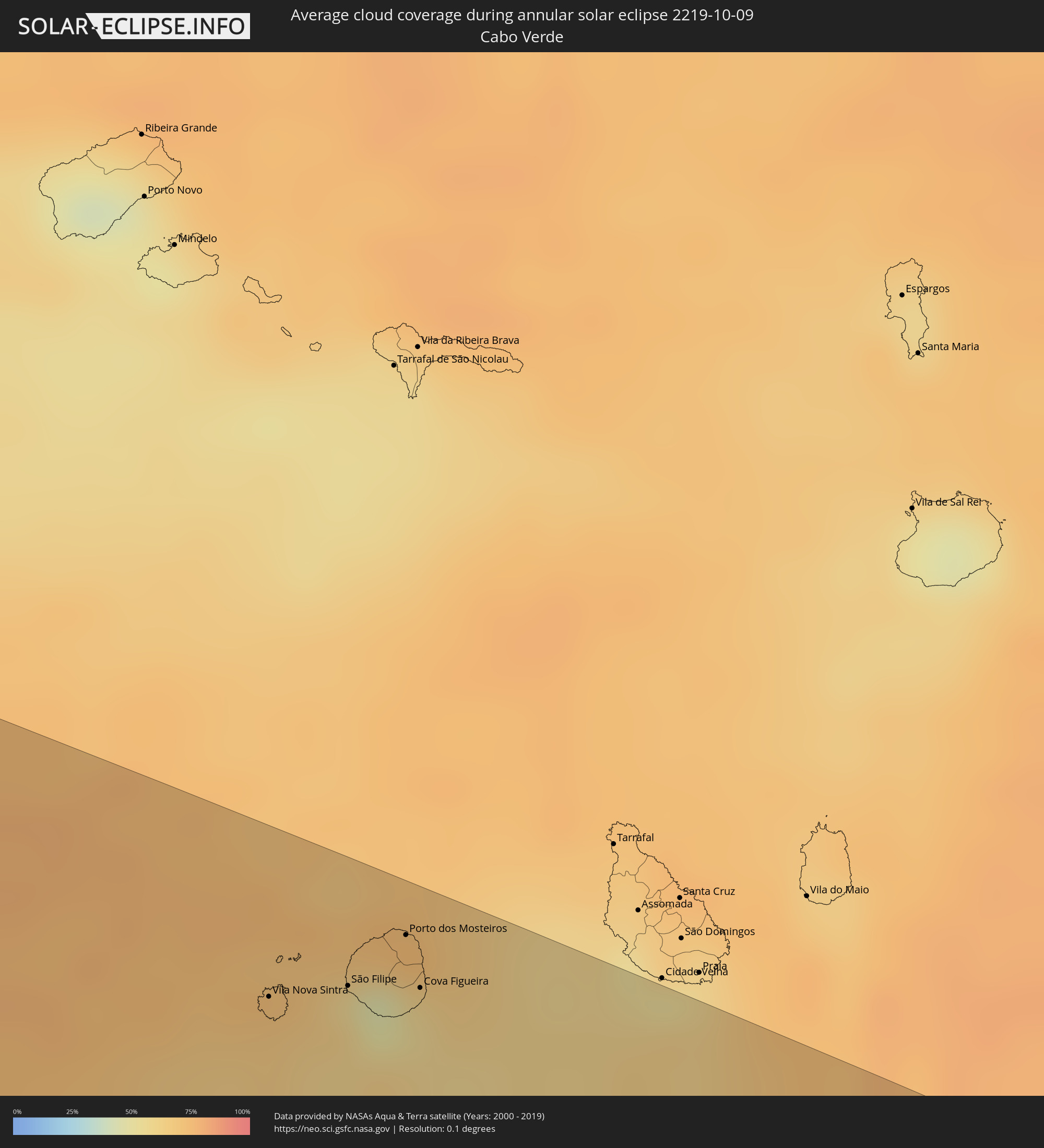 Cabo Verde
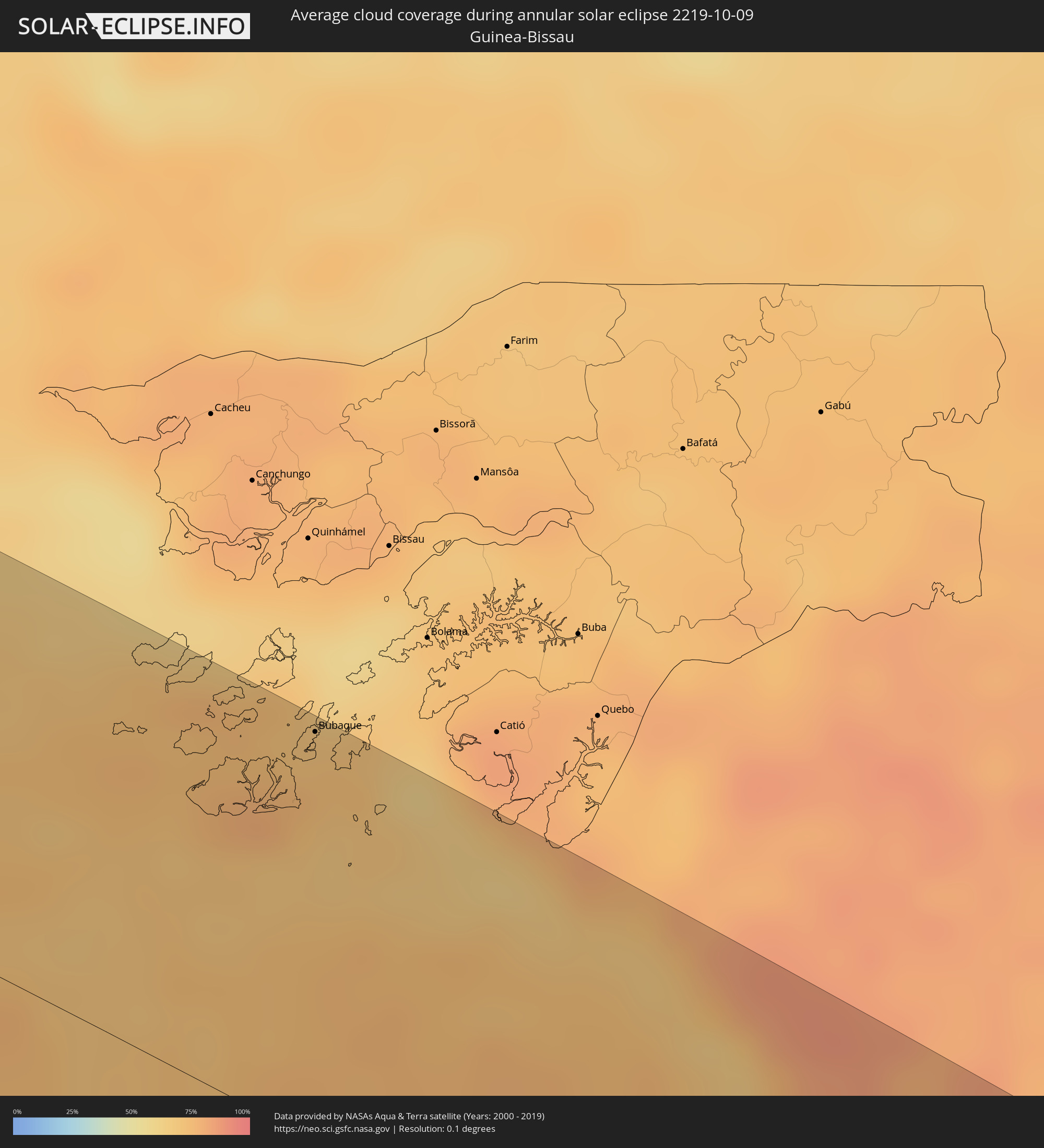 Guinea-Bissau
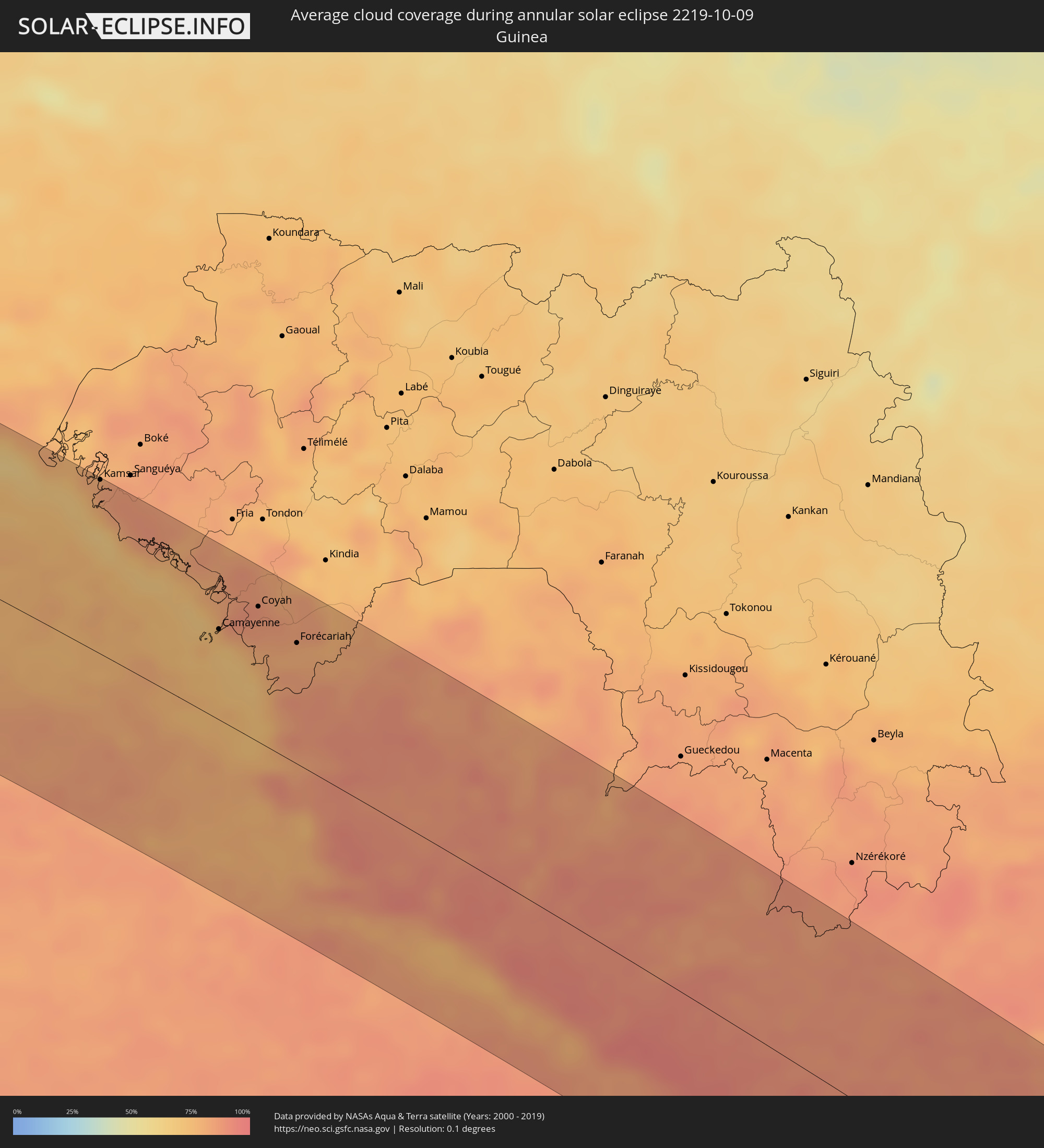 Guinea
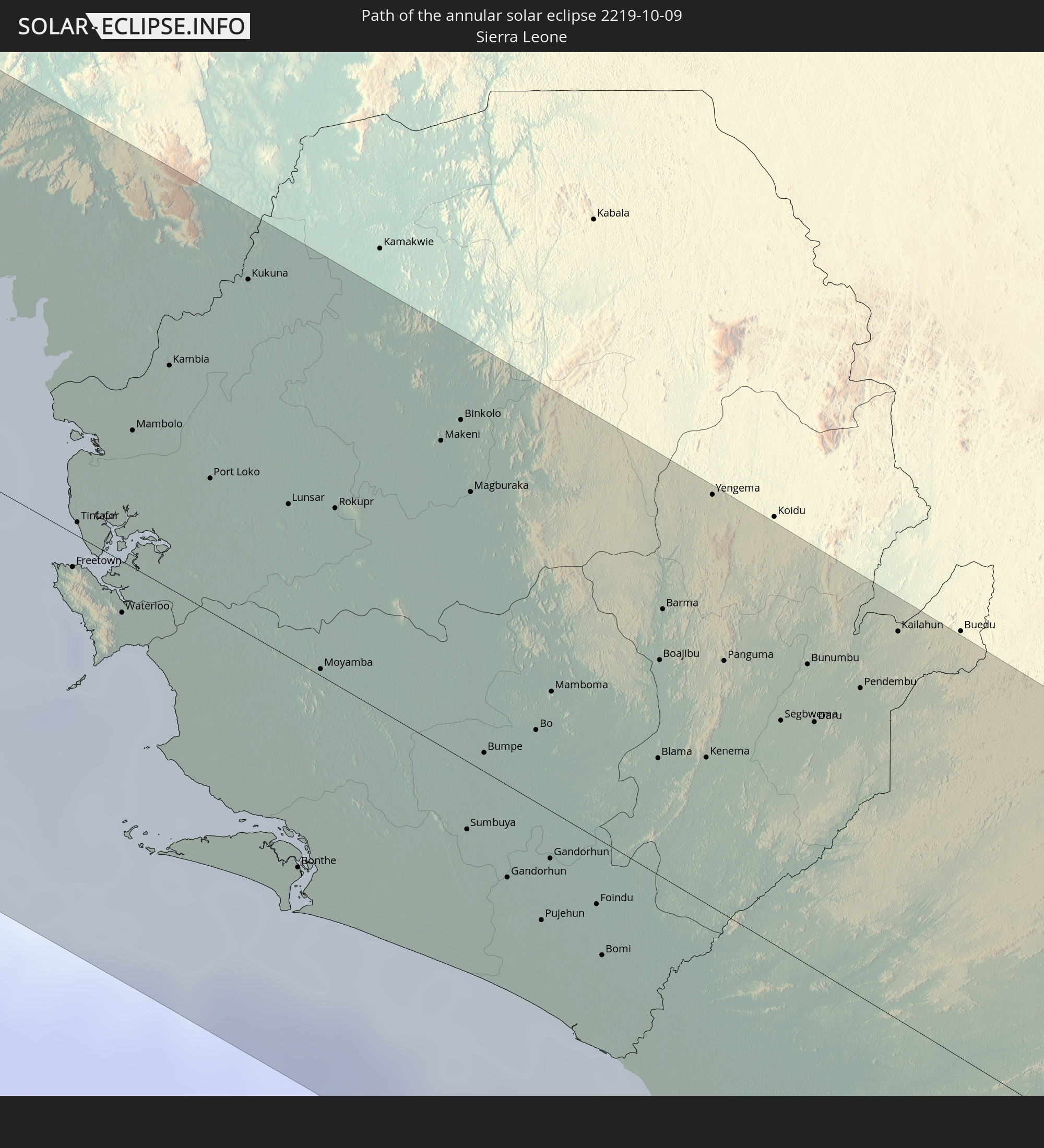
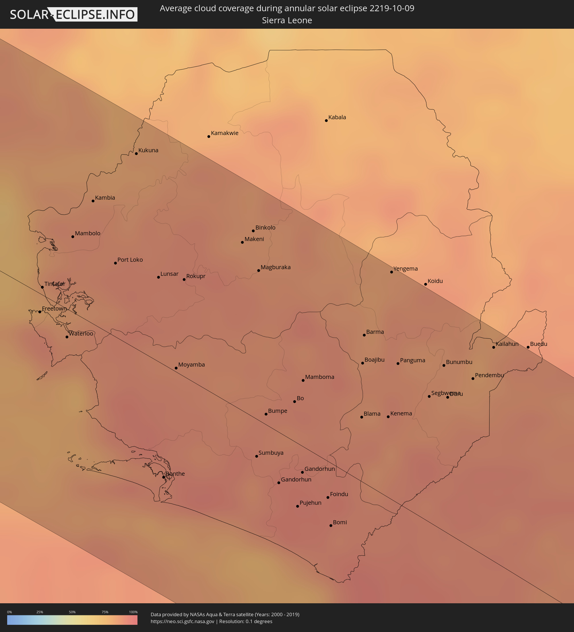 Sierra Leone
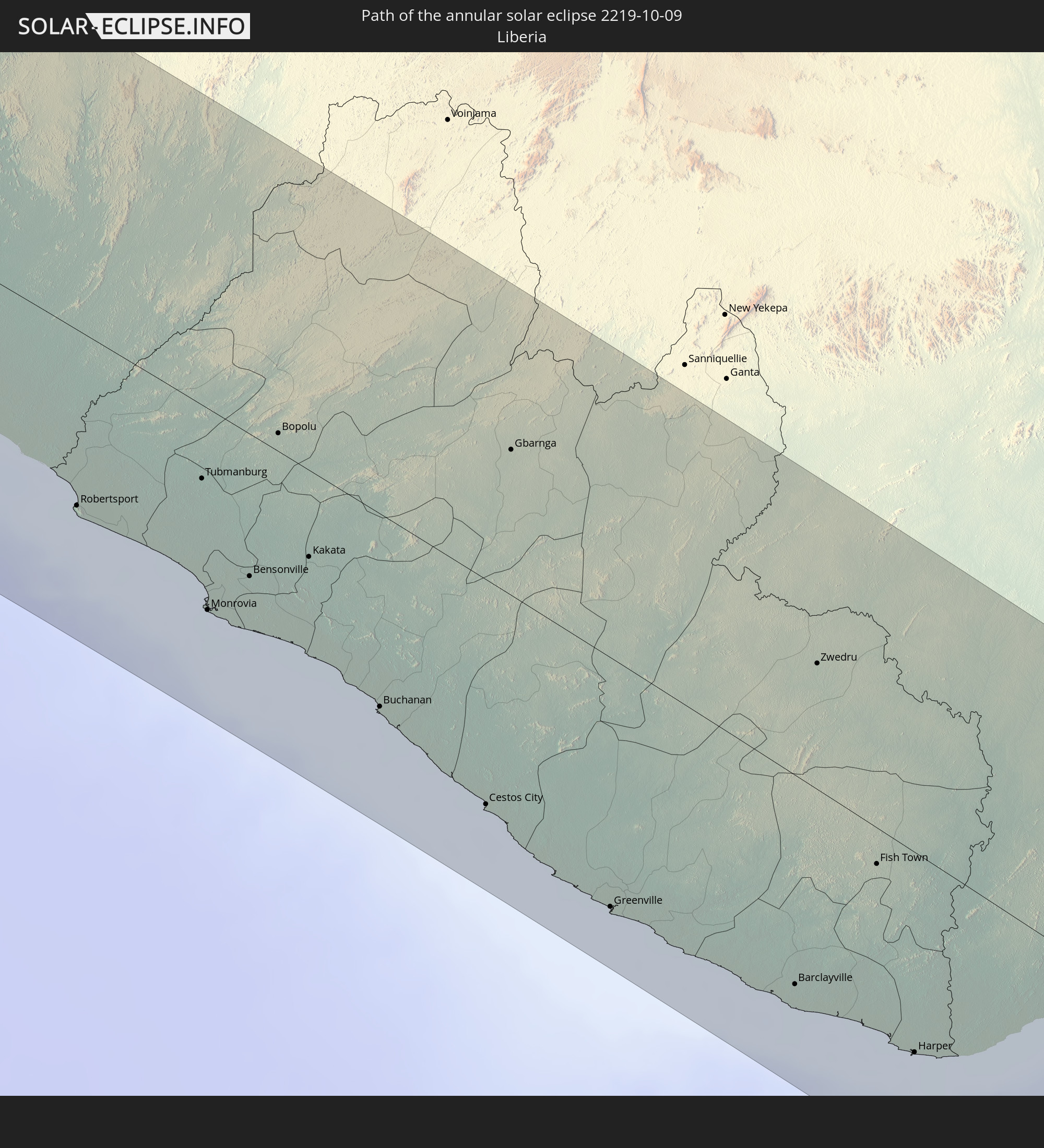
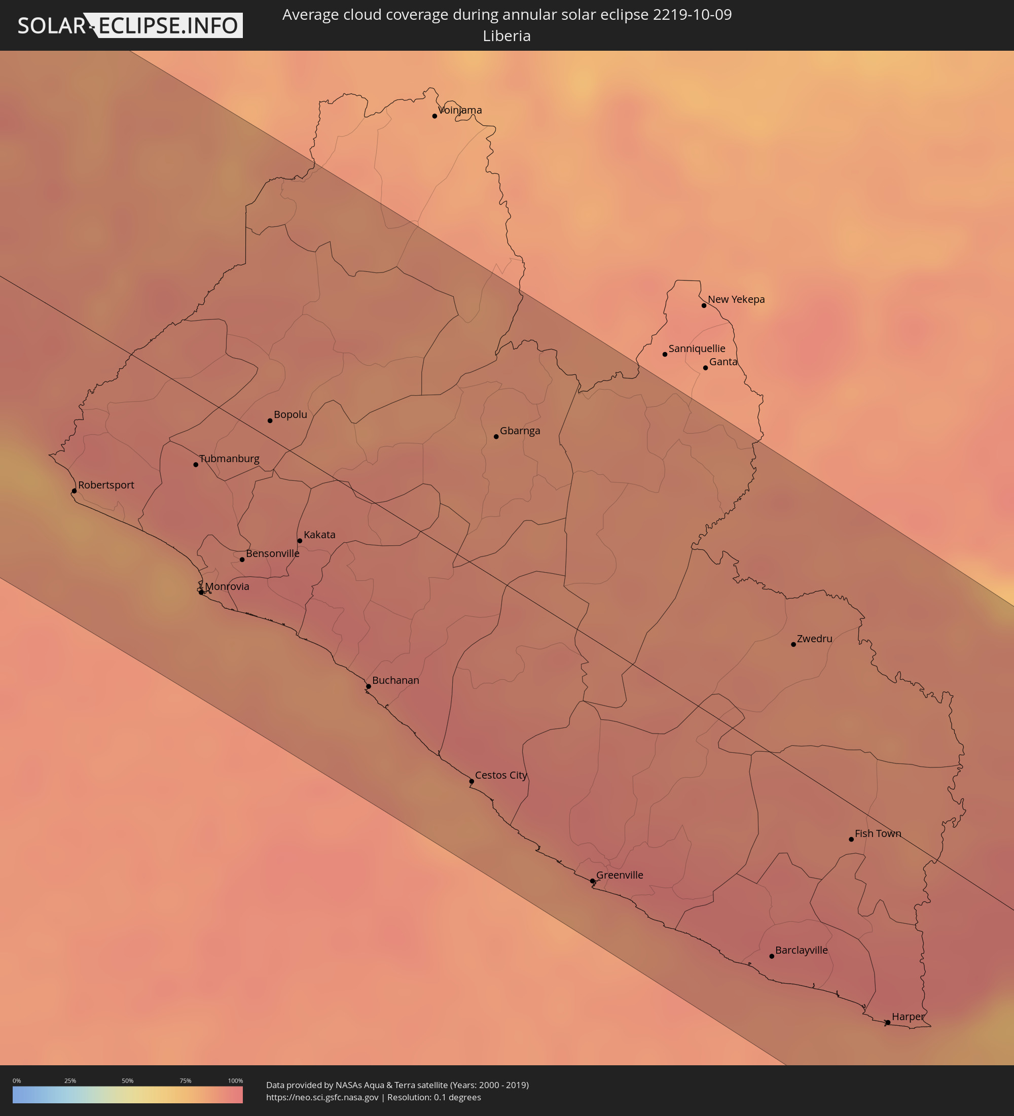 Liberia
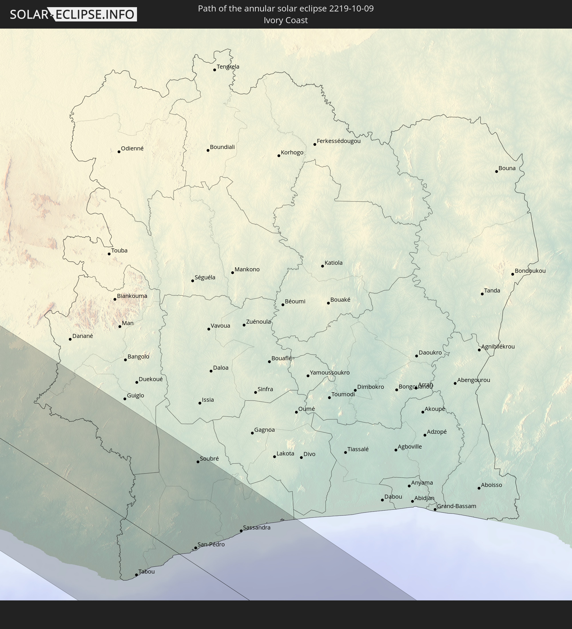
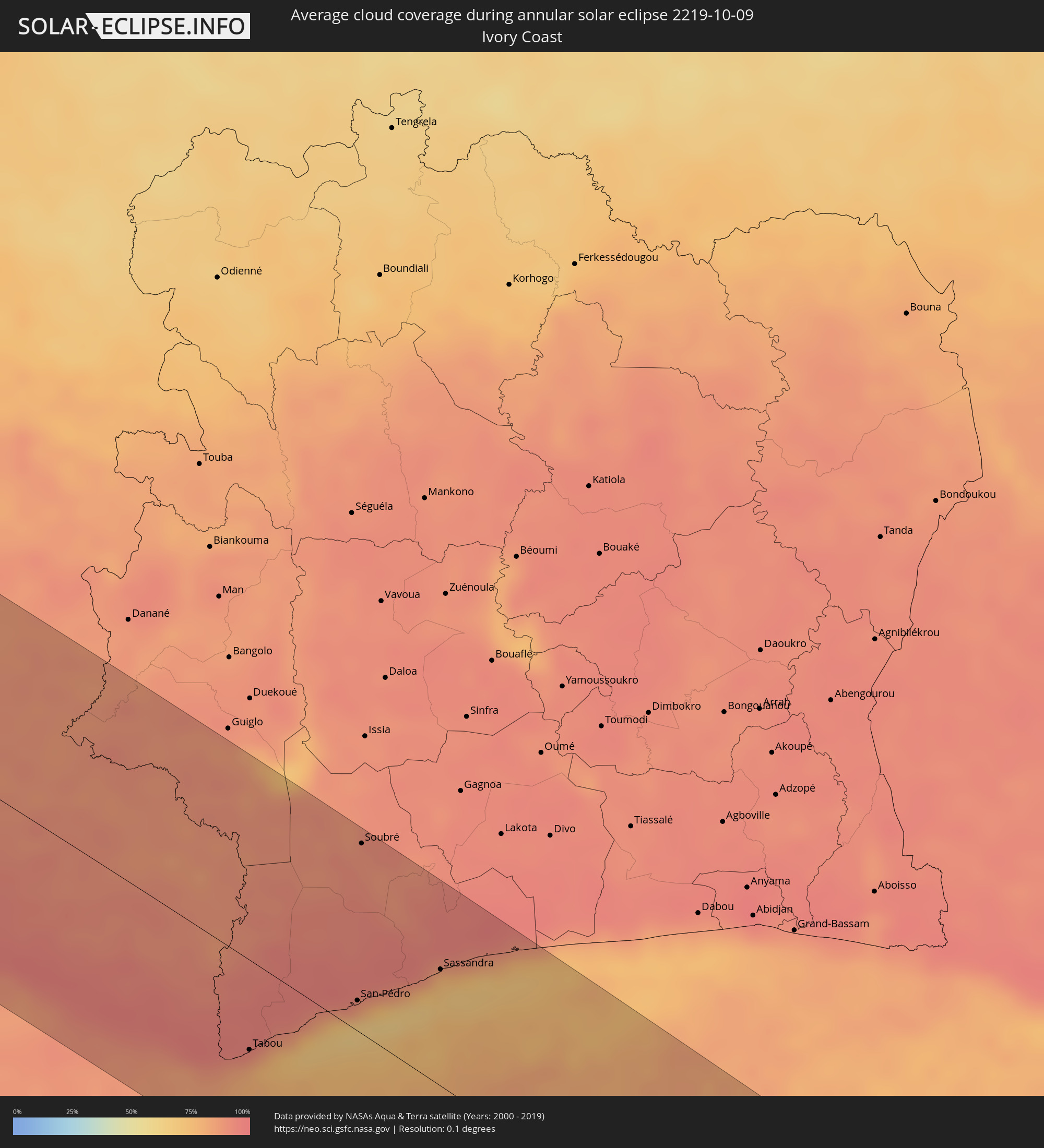 Ivory Coast
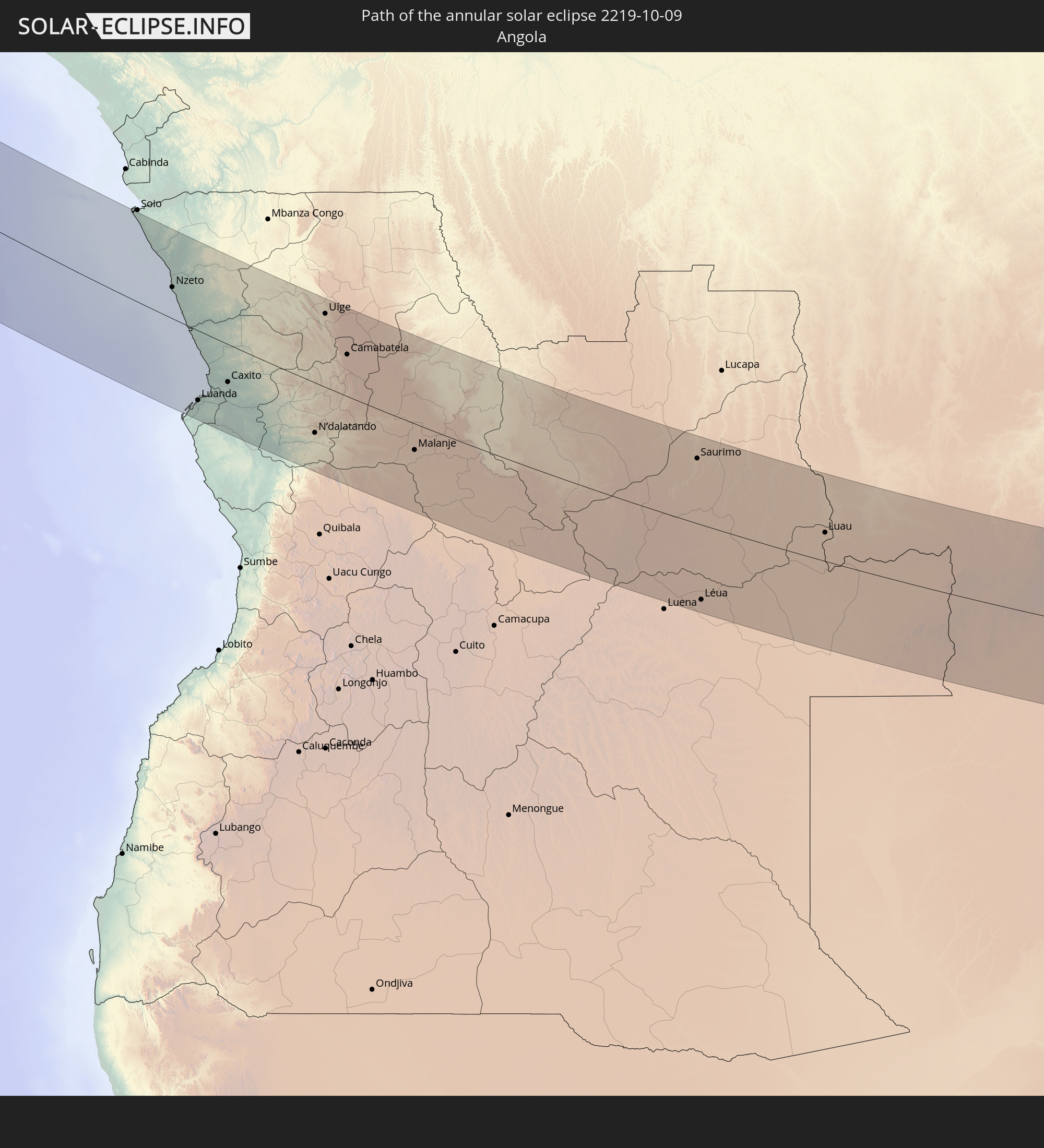
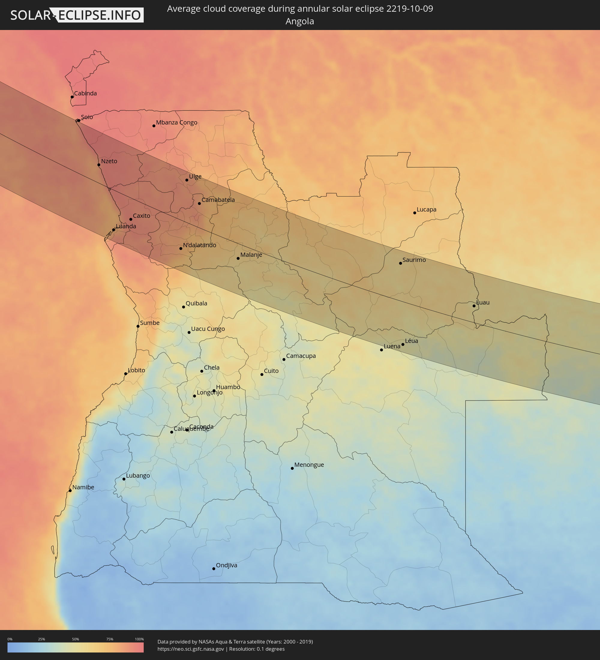 Angola
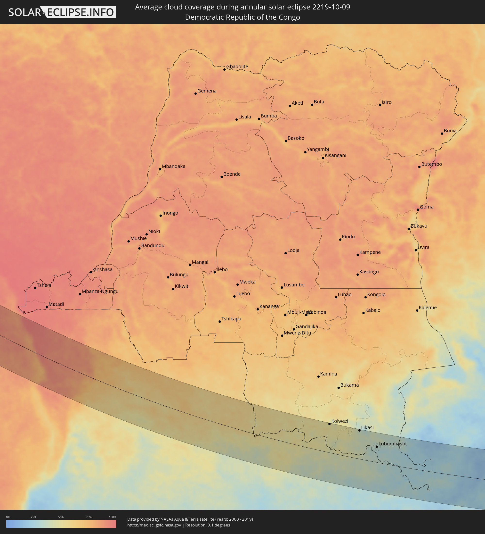 Democratic Republic of the Congo
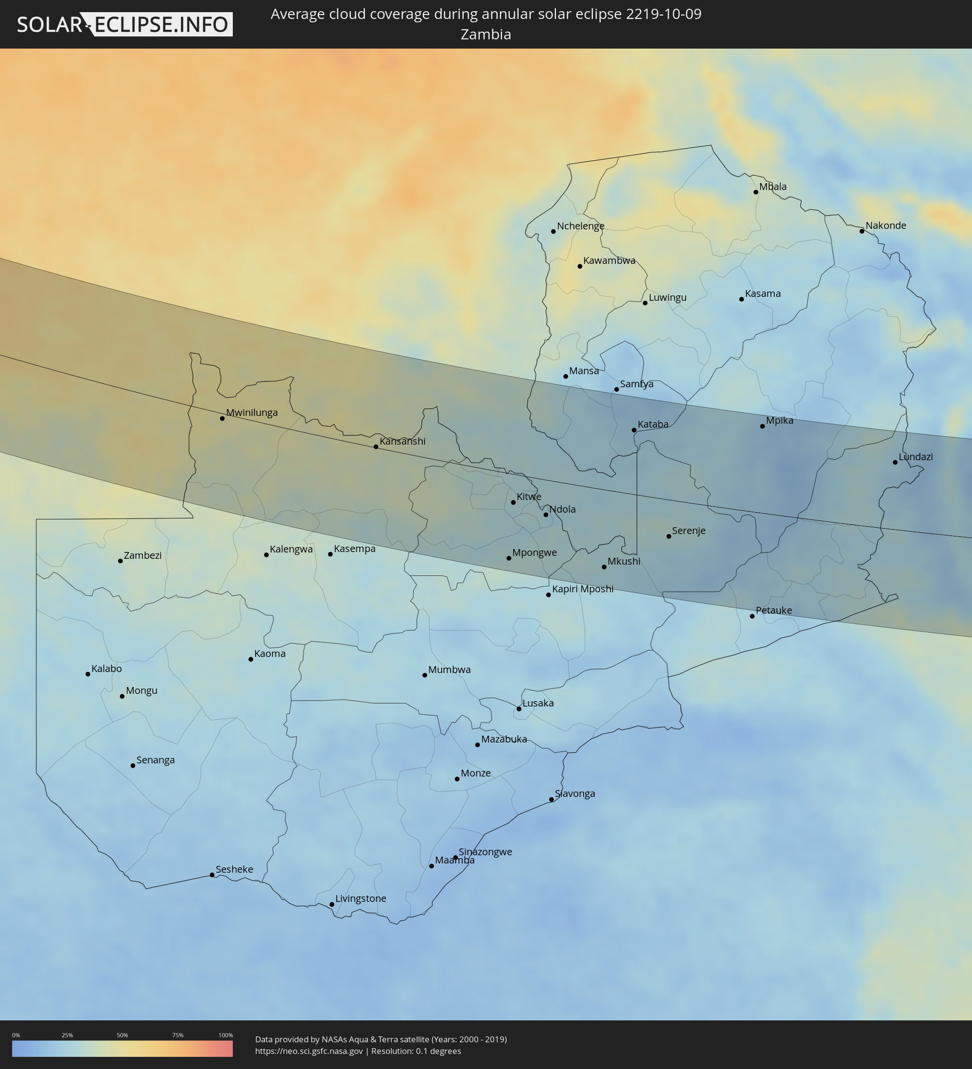 Zambia
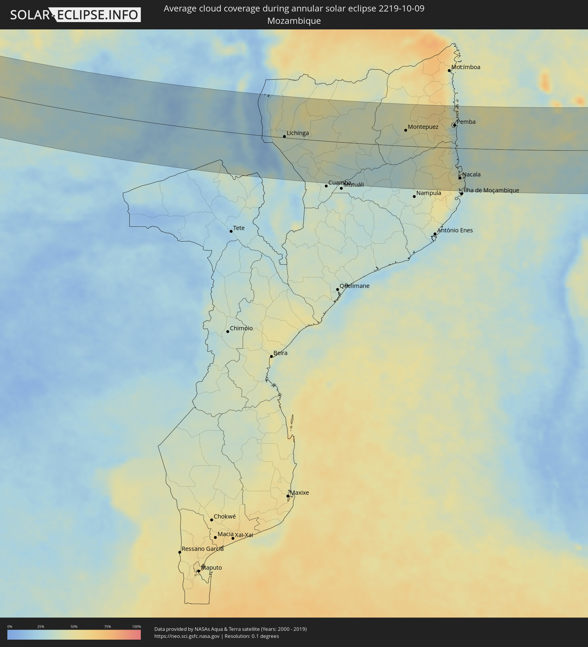 Mozambique
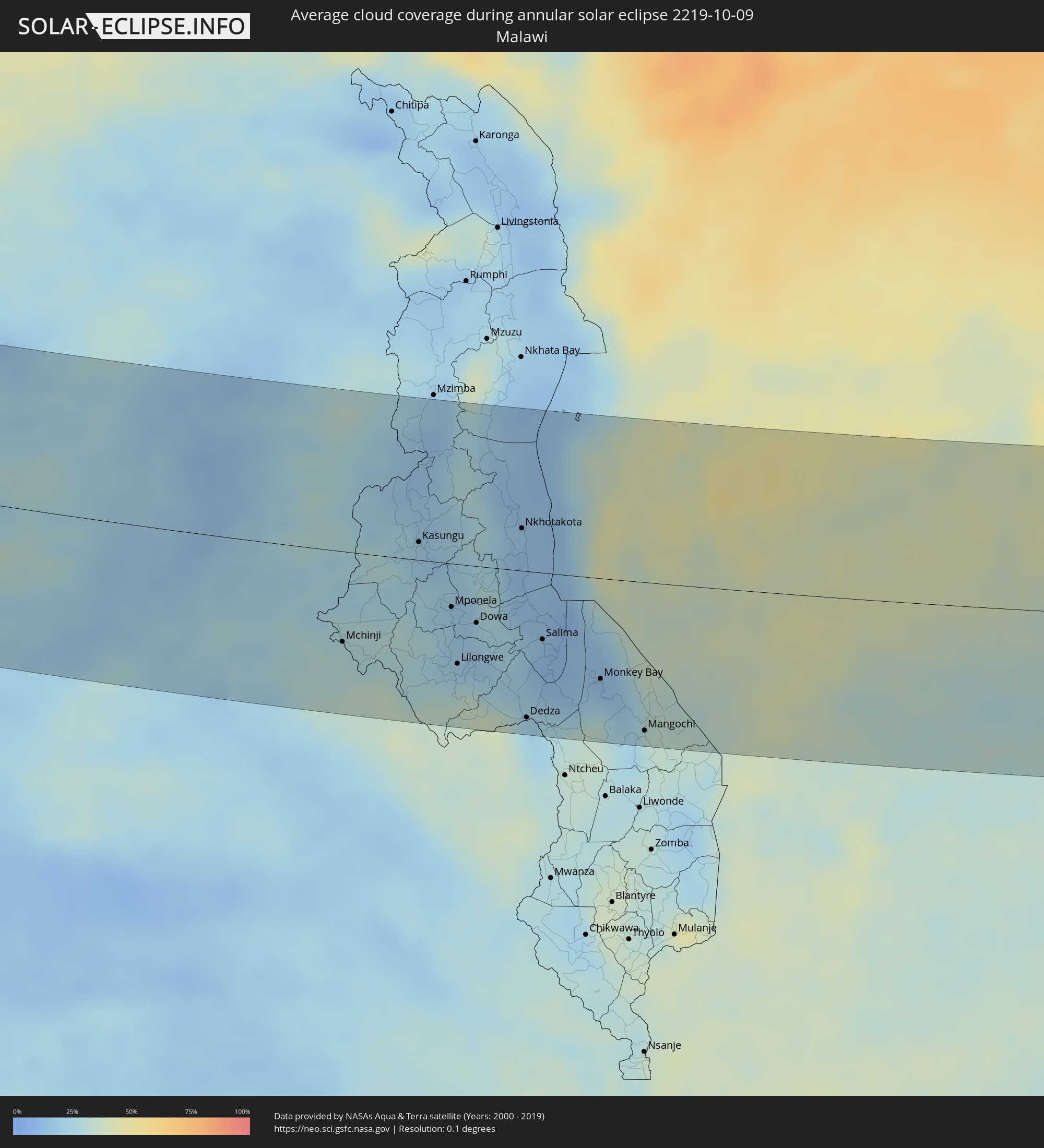 Malawi
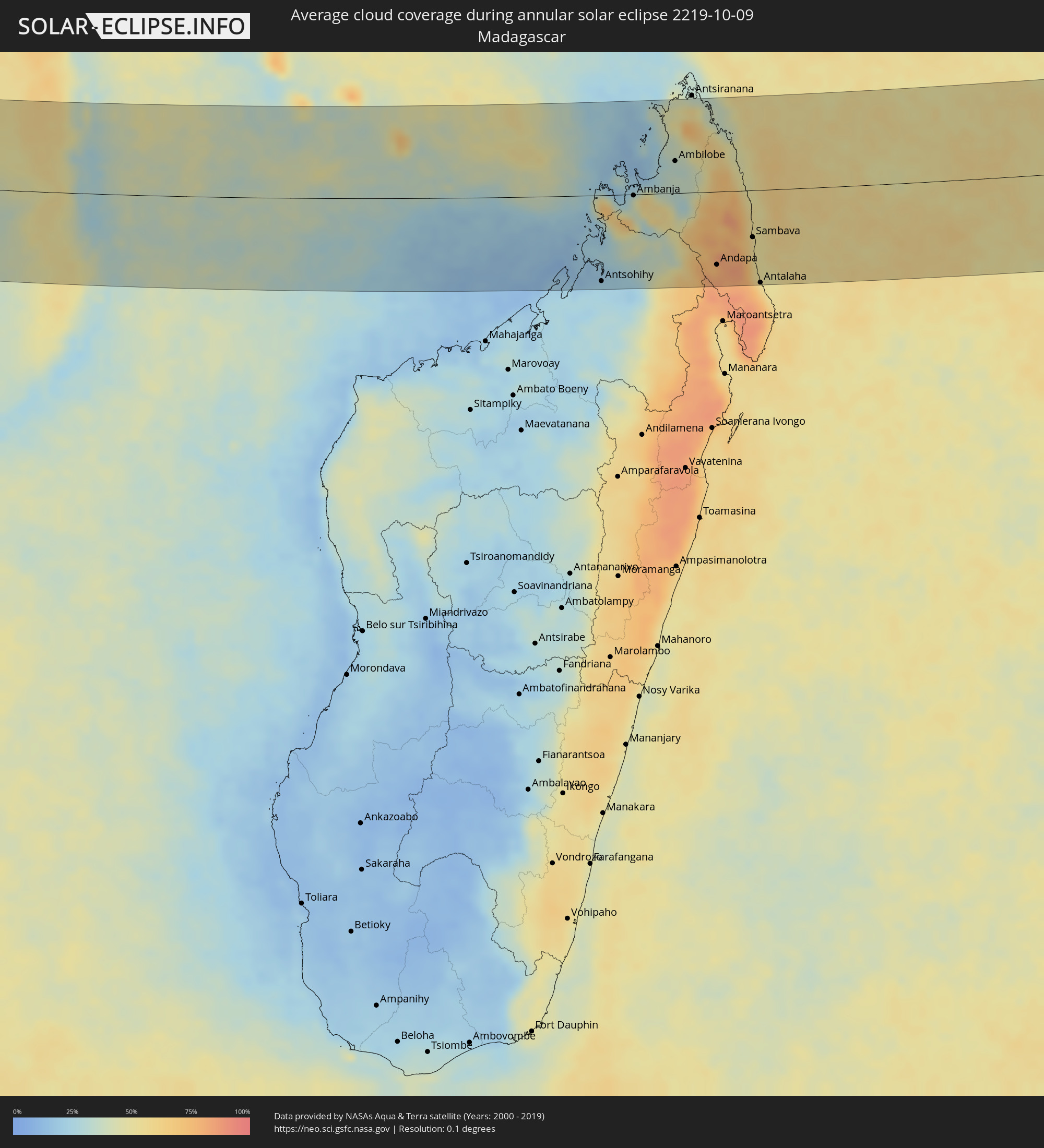 Madagascar
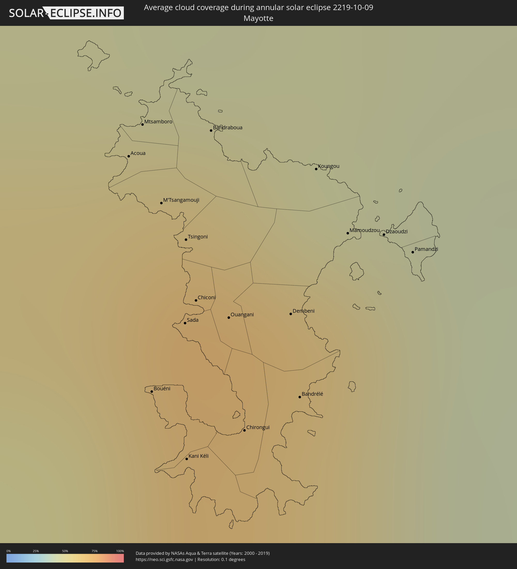 Mayotte
Cities inside the path of the eclipse
The following table shows all locations with a population of more than 5,000 inside the eclipse path. Cities which have more than 100,000 inhabitants are marked bold. A click at the locations opens a detailed map.
| City | Type | Eclipse duration | Local time of max. eclipse | Distance to central line | Ø Cloud coverage |
|
Vila Nova Sintra, Brava
|
annular | - | 09:04:13 UTC-01:00 | 89 km | 68% |
|
São Filipe, São Filipe
|
annular | - | 09:04:31 UTC-01:00 | 100 km | 62% |
|
Porto dos Mosteiros, Mosteiros
|
annular | - | 09:04:39 UTC-01:00 | 121 km | 60% |
|
Cova Figueira, Santa Catarina do Fogo
|
annular | - | 09:04:49 UTC-01:00 | 108 km | 55% |
|
Bubaque, Bolama and Bijagos
|
annular | - | 10:23:24 UTC+00:00 | 126 km | 72% |
|
Kamsar, Boke
|
annular | - | 10:26:49 UTC+00:00 | 129 km | 82% |
|
Camayenne, Conakry
|
annular | - | 10:30:23 UTC+00:00 | 67 km | 72% |
|
Conakry, Conakry
|
annular | - | 10:30:24 UTC+00:00 | 68 km | 72% |
|
Dubréka, Kindia
|
annular | - | 10:30:24 UTC+00:00 | 100 km | 88% |
|
Coyah, Kindia
|
annular | - | 10:30:50 UTC+00:00 | 100 km | 87% |
|
Freetown, Western Area
|
annular | - | 10:32:58 UTC+00:00 | 10 km | 88% |
|
Forécariah, Kindia
|
annular | - | 10:31:54 UTC+00:00 | 89 km | 80% |
|
Waterloo, Western Area
|
annular | - | 10:33:33 UTC+00:00 | 16 km | 86% |
|
Kambia, Northern Province
|
annular | - | 10:32:45 UTC+00:00 | 69 km | 88% |
|
Port Loko, Northern Province
|
annular | - | 10:33:35 UTC+00:00 | 41 km | 90% |
|
Lunsar, Northern Province
|
annular | - | 10:34:18 UTC+00:00 | 47 km | 89% |
|
Rokupr, Northern Province
|
annular | - | 10:34:40 UTC+00:00 | 54 km | 90% |
|
Makeni, Northern Province
|
annular | - | 10:35:10 UTC+00:00 | 93 km | 85% |
|
Magburaka, Northern Province
|
annular | - | 10:35:38 UTC+00:00 | 83 km | 86% |
|
Bumpe, Southern Province
|
annular | - | 10:37:01 UTC+00:00 | 6 km | 88% |
|
Gandorhun, Southern Province
|
annular | - | 10:37:50 UTC+00:00 | 28 km | 92% |
|
Bo, Southern Province
|
annular | - | 10:37:19 UTC+00:00 | 22 km | 91% |
|
Gandorhun, Southern Province
|
annular | - | 10:38:05 UTC+00:00 | 15 km | 92% |
|
Robertsport, Grand Cape Mount
|
annular | - | 10:40:11 UTC+00:00 | 73 km | 83% |
|
Kenema, Eastern Province
|
annular | - | 10:38:48 UTC+00:00 | 45 km | 88% |
|
Yengema, Eastern Province
|
annular | - | 10:37:32 UTC+00:00 | 126 km | 84% |
|
Segbwema, Eastern Province
|
annular | - | 10:39:12 UTC+00:00 | 69 km | 86% |
|
Tubmanburg, Bomi
|
annular | - | 10:41:22 UTC+00:00 | 30 km | 90% |
|
Monrovia, Montserrado
|
annular | - | 10:42:23 UTC+00:00 | 83 km | 86% |
|
Bensonville, Montserrado
|
annular | - | 10:42:36 UTC+00:00 | 59 km | 96% |
|
Kailahun, Eastern Province
|
annular | - | 10:39:42 UTC+00:00 | 118 km | 85% |
|
Bopolu, Gbarpolu
|
annular | - | 10:41:53 UTC+00:00 | 7 km | 90% |
|
Kakata, Margibi
|
annular | - | 10:43:07 UTC+00:00 | 36 km | 94% |
|
Buchanan, Grand Bassa
|
annular | - | 10:45:02 UTC+00:00 | 79 km | 91% |
|
Cestos City, River Cess
|
annular | - | 10:47:00 UTC+00:00 | 92 km | 87% |
|
Gbarnga, Bong
|
annular | - | 10:44:37 UTC+00:00 | 60 km | 88% |
|
Greenville, Sinoe
|
annular | - | 10:49:15 UTC+00:00 | 102 km | 90% |
|
Toulépleu Gueré, Montagnes
|
annular | - | 10:48:06 UTC+00:00 | 81 km | 89% |
|
Barclayville, Grand Kru
|
annular | - | 10:52:03 UTC+00:00 | 85 km | 96% |
|
Zwedru, Grand Gedeh
|
annular | - | 10:49:47 UTC+00:00 | 51 km | 88% |
|
Fish Town, River Gee
|
annular | - | 10:52:04 UTC+00:00 | 15 km | 90% |
|
Harper, Maryland
|
annular | - | 10:54:03 UTC+00:00 | 81 km | 89% |
|
Tabou, Bas-Sassandra
|
annular | - | 10:54:58 UTC+00:00 | 55 km | 82% |
|
San-Pédro, Bas-Sassandra
|
annular | - | 10:56:21 UTC+00:00 | 19 km | 65% |
|
Soubré, Bas-Sassandra
|
annular | - | 10:54:30 UTC+00:00 | 117 km | 90% |
|
Sassandra, Bas-Sassandra
|
annular | - | 10:57:32 UTC+00:00 | 71 km | 77% |
|
Nzeto, Zaire
|
annular | - | 13:22:54 UTC+01:00 | 45 km | 92% |
|
Luanda, Luanda
|
annular | - | 13:26:40 UTC+01:00 | 100 km | 85% |
|
Caxito, Bengo
|
annular | - | 13:27:33 UTC+01:00 | 54 km | 91% |
|
N’dalatando, Cuanza Norte
|
annular | - | 13:32:22 UTC+01:00 | 73 km | 77% |
|
Uíge, Uíge
|
annular | - | 13:30:14 UTC+01:00 | 107 km | 88% |
|
Camabatela, Cuanza Norte
|
annular | - | 13:32:04 UTC+01:00 | 61 km | 82% |
|
Malanje, Malanje
|
annular | - | 13:36:51 UTC+01:00 | 38 km | 58% |
|
Saurimo, Lunda Sul
|
annular | - | 13:48:07 UTC+01:00 | 97 km | 58% |
|
Léua, Moxico
|
annular | - | 13:50:30 UTC+01:00 | 112 km | 47% |
|
Luau, Moxico
|
annular | - | 13:53:55 UTC+01:00 | 43 km | 52% |
|
Mwinilunga, North-Western
|
annular | - | 15:00:04 UTC+02:00 | 8 km | 44% |
|
Kolwezi, Katanga
|
annular | - | 15:01:30 UTC+02:00 | 129 km | 51% |
|
Solwezi, North-Western
|
annular | - | 15:04:40 UTC+02:00 | 8 km | 40% |
|
Kansanshi, North-Western
|
annular | - | 15:04:42 UTC+02:00 | 1 km | 41% |
|
Likasi, Katanga
|
annular | - | 15:04:29 UTC+02:00 | 129 km | 38% |
|
Kipushi, Katanga
|
annular | - | 15:06:09 UTC+02:00 | 55 km | 32% |
|
Lubumbashi, Katanga
|
annular | - | 15:06:32 UTC+02:00 | 70 km | 31% |
|
Kalulushi, Copperbelt
|
annular | - | 15:08:35 UTC+02:00 | 47 km | 28% |
|
Mpongwe, Copperbelt
|
annular | - | 15:09:08 UTC+02:00 | 119 km | 31% |
|
Kitwe, Copperbelt
|
annular | - | 15:08:48 UTC+02:00 | 40 km | 26% |
|
Mufulira, Copperbelt
|
annular | - | 15:08:41 UTC+02:00 | 12 km | 29% |
|
Luanshya, Copperbelt
|
annular | - | 15:09:24 UTC+02:00 | 73 km | 27% |
|
Ndola, Copperbelt
|
annular | - | 15:09:42 UTC+02:00 | 49 km | 27% |
|
Mkushi, Central
|
annular | - | 15:11:31 UTC+02:00 | 108 km | 26% |
|
Kataba, Copperbelt
|
annular | - | 15:11:11 UTC+02:00 | 89 km | 20% |
|
Serenje, Central
|
annular | - | 15:12:49 UTC+02:00 | 52 km | 28% |
|
Mpika, Muchinga Province
|
annular | - | 15:14:09 UTC+02:00 | 121 km | 17% |
|
Mchinji, Central Region
|
annular | - | 15:17:32 UTC+02:00 | 77 km | 29% |
|
Lundazi, Eastern
|
annular | - | 15:17:18 UTC+02:00 | 94 km | 24% |
|
Kasungu, Central Region
|
annular | - | 15:18:08 UTC+02:00 | 15 km | 19% |
|
Mponela, Central Region
|
annular | - | 15:18:45 UTC+02:00 | 37 km | 21% |
|
Lilongwe, Central Region
|
annular | - | 15:19:00 UTC+02:00 | 85 km | 26% |
|
Ntchisi, Central Region
|
annular | - | 15:19:01 UTC+02:00 | 34 km | 20% |
|
Dowa, Central Region
|
annular | - | 15:19:06 UTC+02:00 | 48 km | 19% |
|
Nkhotakota, Central Region
|
annular | - | 15:19:20 UTC+02:00 | 36 km | 16% |
|
Dedza, Central Region
|
annular | - | 15:19:58 UTC+02:00 | 124 km | 25% |
|
Salima, Central Region
|
annular | - | 15:19:56 UTC+02:00 | 57 km | 12% |
|
Monkey Bay, Southern Region
|
annular | - | 15:20:42 UTC+02:00 | 85 km | 17% |
|
Lichinga, Niassa
|
annular | - | 15:20:53 UTC+02:00 | 3 km | 37% |
|
Mangochi, Southern Region
|
annular | - | 15:21:20 UTC+02:00 | 126 km | 31% |
|
Montepuez, Cabo Delgado
|
annular | - | 15:25:45 UTC+02:00 | 52 km | 43% |
|
Pemba, Cabo Delgado
|
annular | - | 15:27:26 UTC+02:00 | 76 km | 30% |
|
Nacala, Nampula
|
annular | - | 15:28:00 UTC+02:00 | 100 km | 44% |
|
Acoua, Acoua
|
annular | - | 16:31:46 UTC+03:00 | 111 km | 70% |
|
Mtsamboro, Mtsamboro
|
annular | - | 16:31:46 UTC+03:00 | 114 km | 70% |
|
Bouéni, Bouéni
|
annular | - | 16:31:49 UTC+03:00 | 91 km | 56% |
|
M'Tsangamouji, M'Tsangamouji
|
annular | - | 16:31:48 UTC+03:00 | 107 km | 66% |
|
Sada, Sada
|
annular | - | 16:31:50 UTC+03:00 | 97 km | 56% |
|
Tsingoni, Tsingoni
|
annular | - | 16:31:49 UTC+03:00 | 104 km | 66% |
|
Kani Kéli, Kani-Kéli
|
annular | - | 16:31:51 UTC+03:00 | 85 km | 41% |
|
Chiconi, Chiconi
|
annular | - | 16:31:50 UTC+03:00 | 99 km | 66% |
|
Bandraboua, Bandraboua
|
annular | - | 16:31:49 UTC+03:00 | 113 km | 70% |
|
Ouangani, Ouangani
|
annular | - | 16:31:51 UTC+03:00 | 97 km | 66% |
|
Chirongui, Chirongui
|
annular | - | 16:31:53 UTC+03:00 | 88 km | 56% |
|
Dembeni, Dembeni
|
annular | - | 16:31:54 UTC+03:00 | 98 km | 59% |
|
Bandrélé, Bandrele
|
annular | - | 16:31:55 UTC+03:00 | 91 km | 50% |
|
Mamoudzou, Mamoudzou
|
annular | - | 16:31:55 UTC+03:00 | 104 km | 59% |
|
Dzaoudzi, Dzaoudzi
|
annular | - | 16:31:57 UTC+03:00 | 104 km | 43% |
|
Pamandzi, Pamandzi
|
annular | - | 16:31:58 UTC+03:00 | 103 km | 43% |
|
Antsohihy, Sofia
|
annular | - | 16:34:14 UTC+03:00 | 133 km | 24% |
|
Hell-Ville, Diana
|
annular | - | 16:34:16 UTC+03:00 | 30 km | 28% |
|
Ambanja, Diana
|
annular | - | 16:34:25 UTC+03:00 | 2 km | 45% |
|
Bealanana, Sofia
|
annular | - | 16:34:42 UTC+03:00 | 98 km | 36% |
|
Antsohimbondrona, Diana
|
annular | - | 16:34:36 UTC+03:00 | 64 km | 30% |
|
Ambarakaraka, Diana
|
annular | - | 16:34:40 UTC+03:00 | 17 km | 36% |
|
Ambilobe, Diana
|
annular | - | 16:34:44 UTC+03:00 | 50 km | 33% |
|
Sadjoavato, Diana
|
annular | - | 16:34:51 UTC+03:00 | 114 km | 66% |
|
Andapa, Sava
|
annular | - | 16:35:14 UTC+03:00 | 113 km | 81% |
|
Ambodivoara, Sava
|
annular | - | 16:35:24 UTC+03:00 | 80 km | 75% |
|
Sambava, Sava
|
annular | - | 16:35:30 UTC+03:00 | 73 km | 53% |
|
Ampahana, Sava
|
annular | - | 16:35:33 UTC+03:00 | 127 km | 64% |
|
Antalaha, Sava
|
annular | - | 16:35:36 UTC+03:00 | 144 km | 58% |