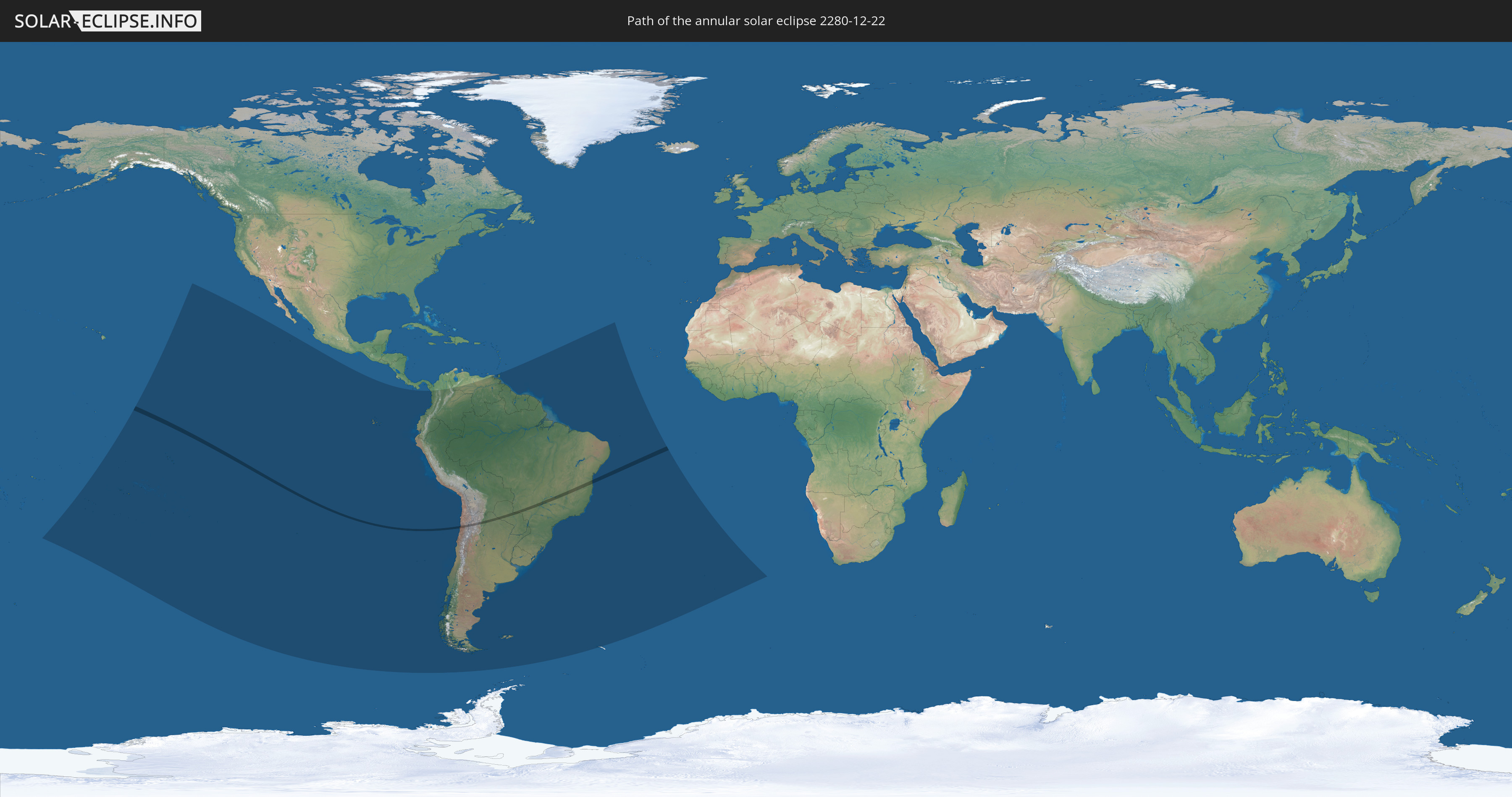
Annular solar eclipse of 12/22/2280
| Day of week: | Wednesday |
| Maximum duration of eclipse: | 01m23s |
| Maximum width of eclipse path: | 46 km |
| Saros cycle: | 146 |
| Coverage: | 98.7% |
| Magnitude: | 0.987 |
| Gamma: | -0.0392 |
Wo kann man die Sonnenfinsternis vom 12/22/2280 sehen?
Die Sonnenfinsternis am 12/22/2280 kann man in 23 Ländern als partielle Sonnenfinsternis beobachten.
Der Finsternispfad verläuft durch 4 Länder. Nur in diesen Ländern ist sie als annular Sonnenfinsternis zu sehen.
In den folgenden Ländern ist die Sonnenfinsternis annular zu sehen
 Chile
Chile
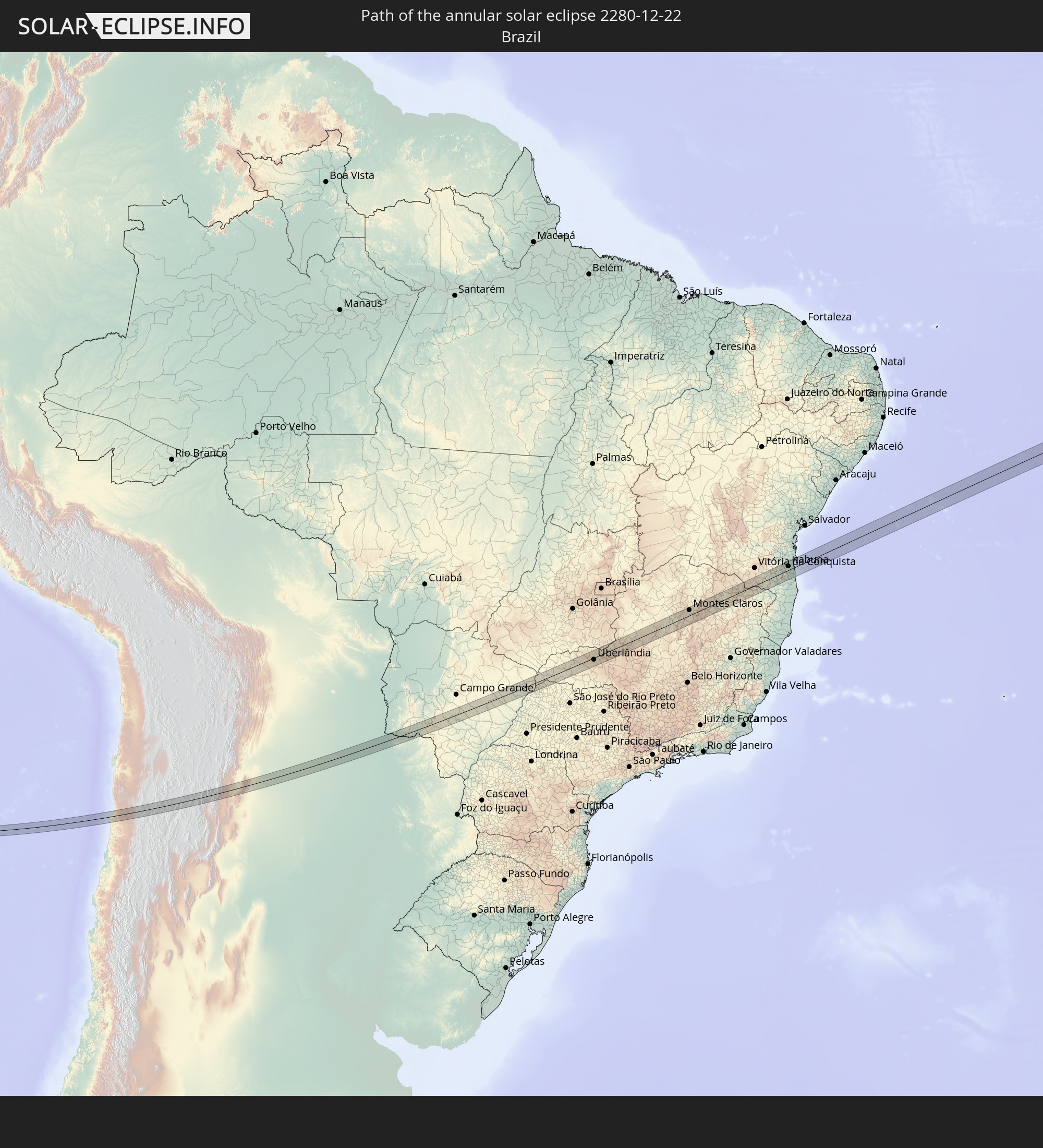 Brazil
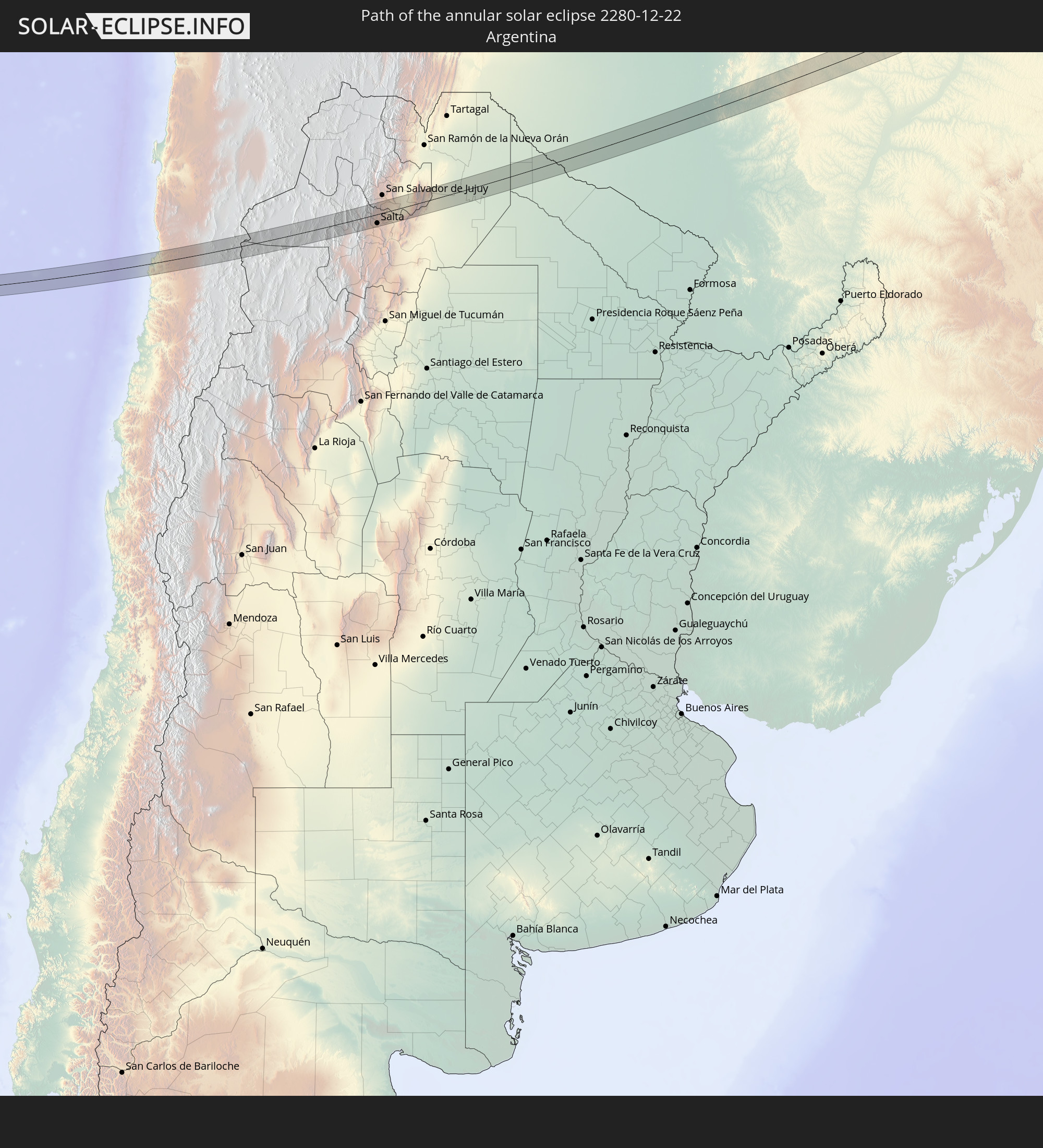 Argentina
 Paraguay
In den folgenden Ländern ist die Sonnenfinsternis partiell zu sehen
 Kiribati
 Cook Islands
 French Polynesia
 Pitcairn Islands
 Mexico
 Chile
Chile
 Ecuador
 Costa Rica
 Colombia
 Peru
Peru
 Brazil
 Argentina
 Venezuela
 Bolivia
 Paraguay
 Trinidad and Tobago
 Falkland Islands
 Guyana
 Uruguay
 Suriname
 French Guiana
 South Georgia and the South Sandwich Islands
 Saint Helena, Ascension and Tristan da Cunha
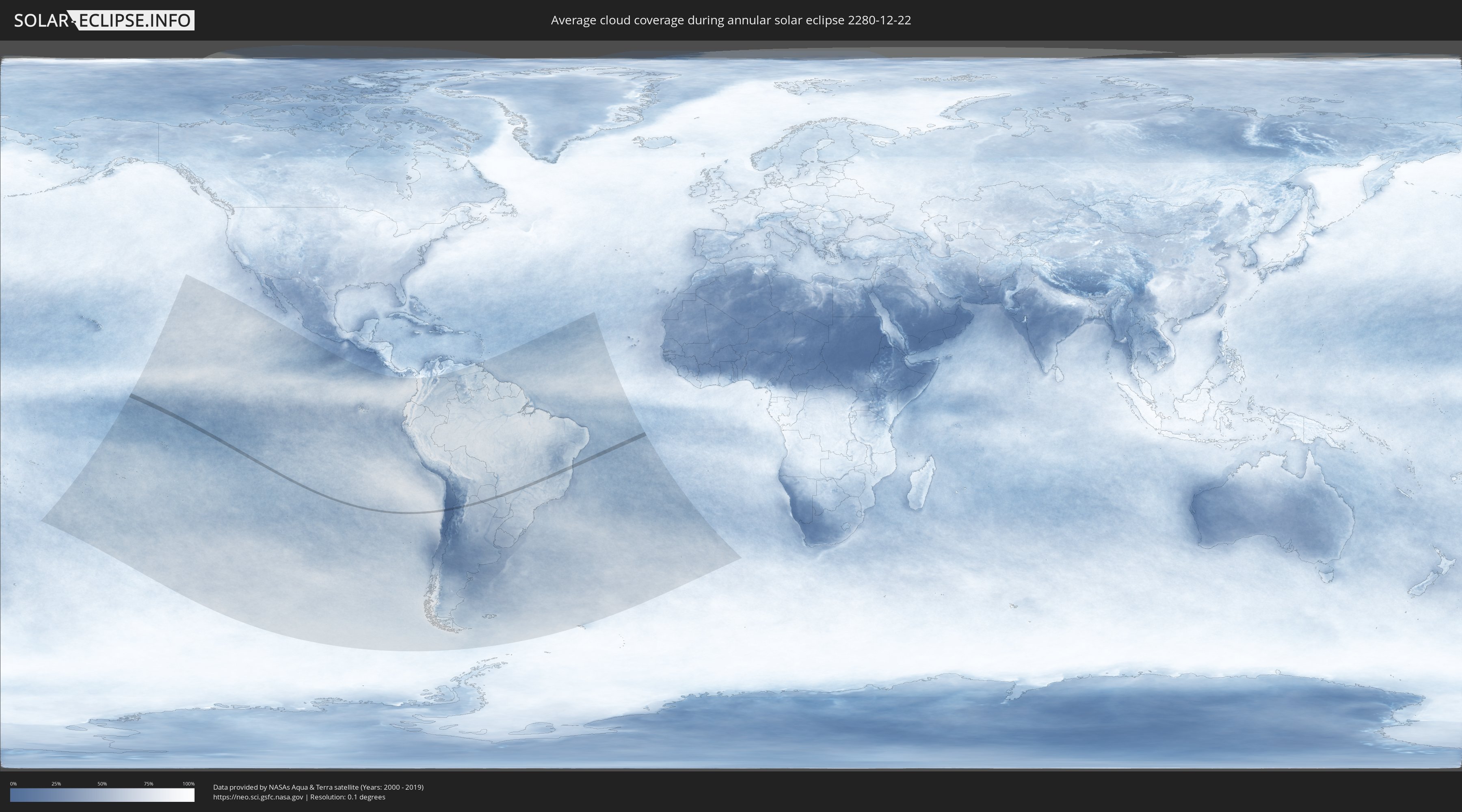
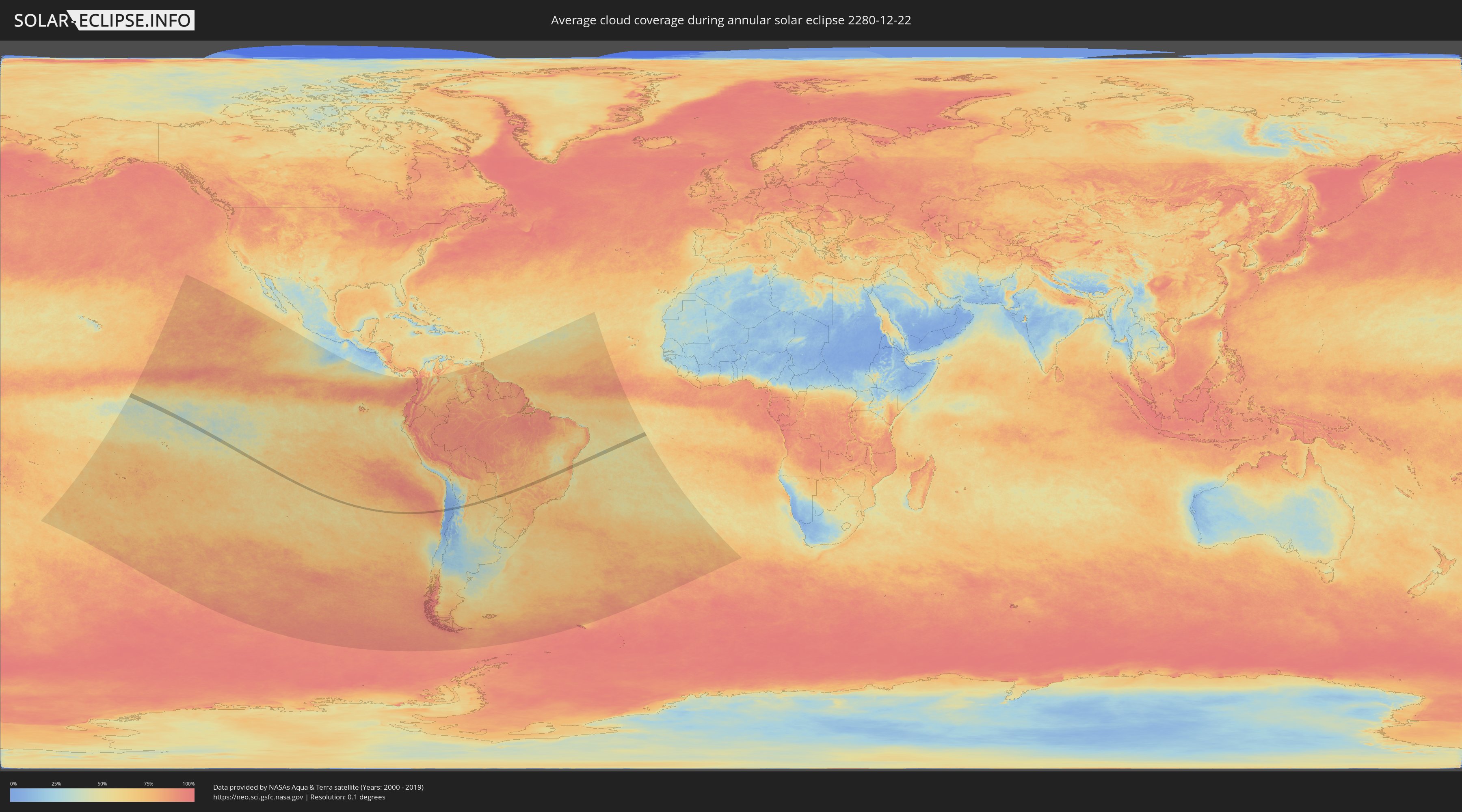
How will be the weather during the annular solar eclipse on 12/22/2280?
Where is the best place to see the annular solar eclipse of 12/22/2280?
The following maps show the average cloud coverage for the day of the annular solar eclipse.
With the help of these maps, it is possible to find the place along the eclipse path, which has the best
chance of a cloudless sky.
Nevertheless, you should consider local circumstances and inform about the weather of your chosen
observation site.
The data is provided by NASAs satellites
AQUA and TERRA.
The cloud maps are averaged over a period of 19 years (2000 - 2019).
Detailed country maps
 Chile
Chile
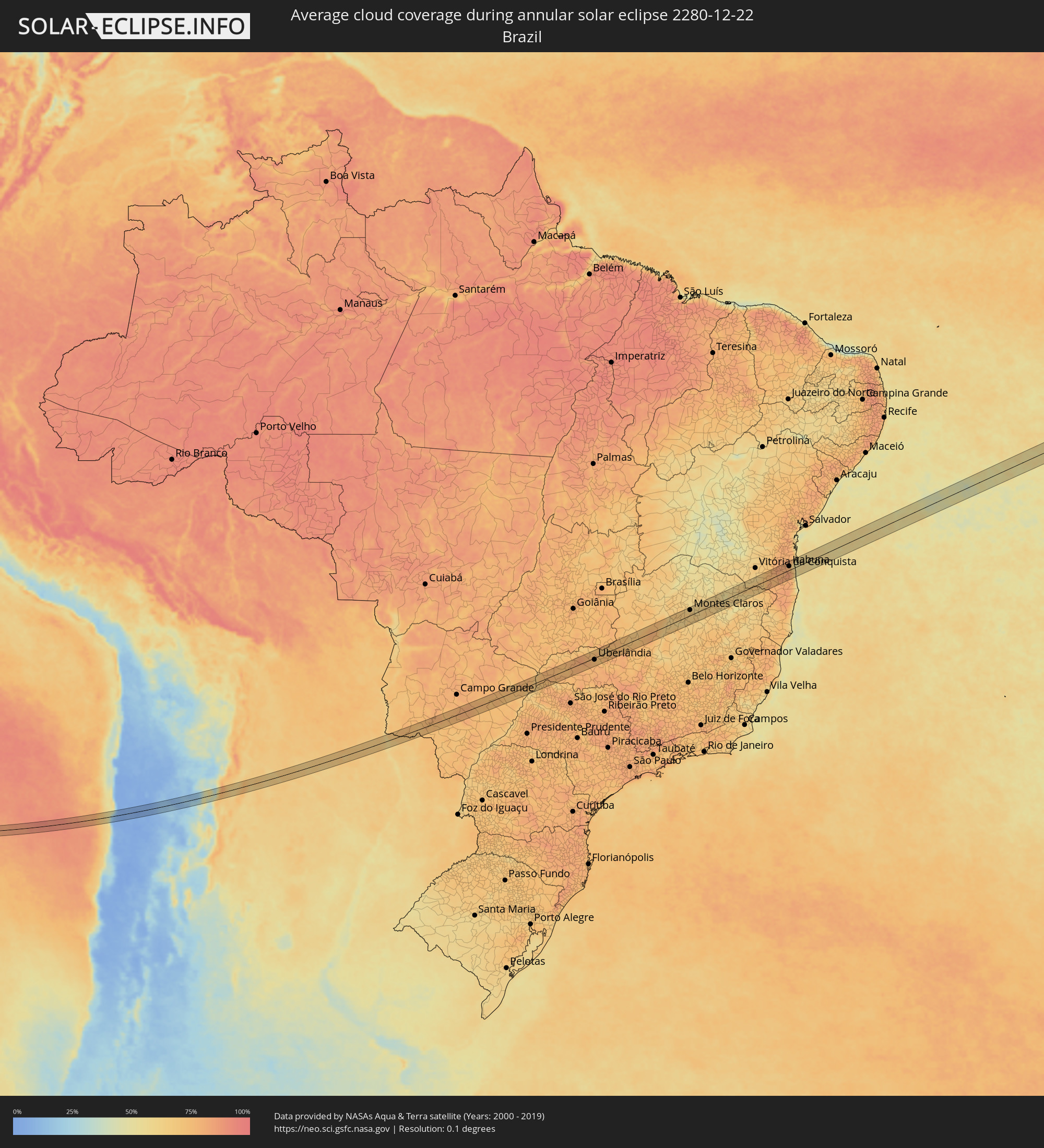 Brazil
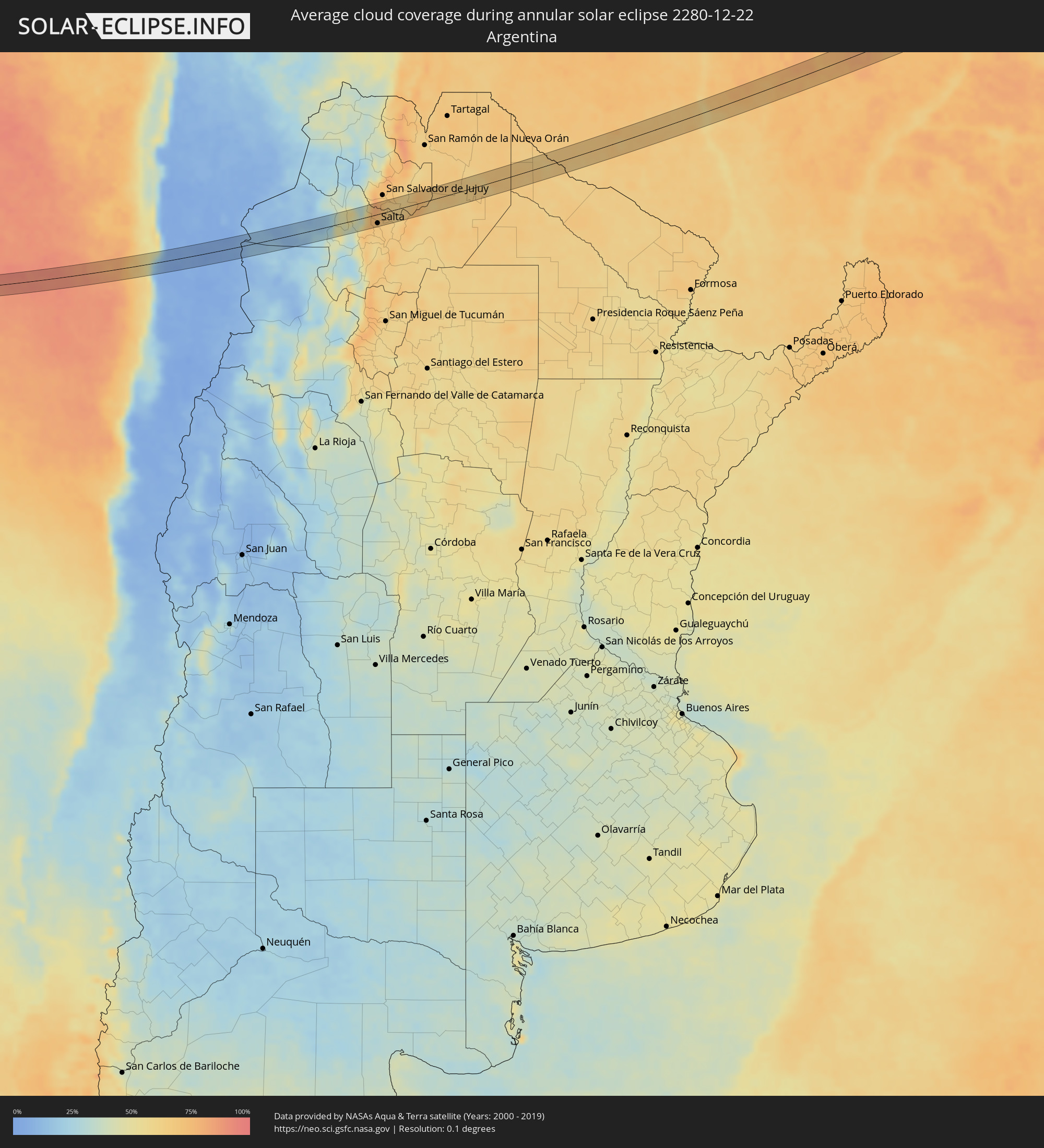 Argentina
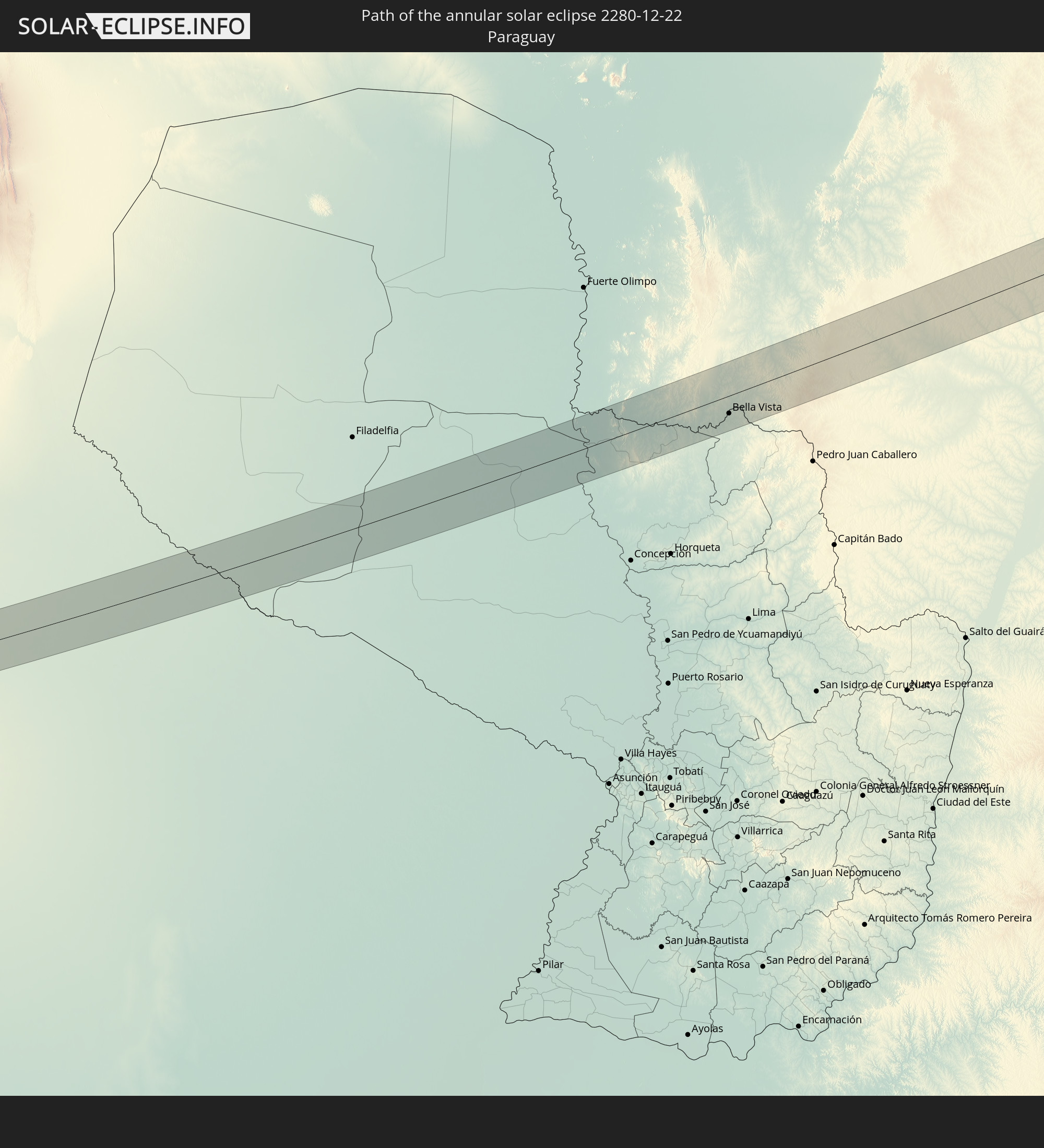
 Paraguay
Cities inside the path of the eclipse
The following table shows all locations with a population of more than 5,000 inside the eclipse path. Cities which have more than 100,000 inhabitants are marked bold. A click at the locations opens a detailed map.
| City | Type | Eclipse duration | Local time of max. eclipse | Distance to central line | Ø Cloud coverage |
|
Taltal, Antofagasta
|
annular | - | 15:31:43 UTC-03:00 | 21 km | 30% |
|
Salta, Salta Province
|
annular | - | 15:44:03 UTC-03:00 | 20 km | 66% |
|
San Pedro, Jujuy Province
|
annular | - | 15:45:40 UTC-03:00 | 25 km | 59% |
|
Ingenio La Esperanza, Jujuy Province
|
annular | - | 15:45:43 UTC-03:00 | 25 km | 60% |
|
Apolinario Saravia, Salta Province
|
annular | - | 15:47:20 UTC-03:00 | 20 km | 64% |
|
Ingeniero Guillermo N. Juárez, Formosa Province
|
annular | - | 15:52:05 UTC-03:00 | 25 km | 66% |
|
Bela Vista, Mato Grosso do Sul
|
annular | - | 16:03:02 UTC-03:00 | 13 km | 69% |
|
Bella Vista, Amambay
|
annular | - | 16:03:01 UTC-03:00 | 16 km | 69% |
|
Maracaju, Mato Grosso do Sul
|
annular | - | 15:05:33 UTC-04:00 | 11 km | 73% |
|
Paranaíba, Mato Grosso do Sul
|
annular | - | 15:12:42 UTC-04:00 | 34 km | 72% |
|
Aparecida do Taboado, Mato Grosso do Sul
|
annular | - | 15:12:27 UTC-04:00 | 12 km | 67% |
|
Santa Fé do Sul, São Paulo
|
annular | - | 16:12:32 UTC-03:00 | 31 km | 69% |
|
Iturama, Minas Gerais
|
annular | - | 16:13:51 UTC-03:00 | 12 km | 74% |
|
Campina Verde, Minas Gerais
|
annular | - | 16:14:49 UTC-03:00 | 21 km | 74% |
|
Prata, Minas Gerais
|
annular | - | 16:15:39 UTC-03:00 | 21 km | 79% |
|
Monte Alegre de Minas, Minas Gerais
|
annular | - | 16:16:05 UTC-03:00 | 22 km | 83% |
|
Uberlândia, Minas Gerais
|
annular | - | 16:16:41 UTC-03:00 | 8 km | 77% |
|
Araguari, Minas Gerais
|
annular | - | 16:17:01 UTC-03:00 | 16 km | 76% |
|
Monte Carmelo, Minas Gerais
|
annular | - | 16:17:38 UTC-03:00 | 21 km | 77% |
|
Coromandel, Minas Gerais
|
annular | - | 16:18:09 UTC-03:00 | 8 km | 74% |
|
Vazante, Minas Gerais
|
annular | - | 16:18:52 UTC-03:00 | 29 km | 72% |
|
Presidente Olegário, Minas Gerais
|
annular | - | 16:18:57 UTC-03:00 | 36 km | 74% |
|
João Pinheiro, Minas Gerais
|
annular | - | 16:19:46 UTC-03:00 | 22 km | 69% |
|
Buritizeiro, Minas Gerais
|
annular | - | 16:21:09 UTC-03:00 | 10 km | 64% |
|
Pirapora, Minas Gerais
|
annular | - | 16:21:11 UTC-03:00 | 9 km | 63% |
|
Várzea da Palma, Minas Gerais
|
annular | - | 16:21:08 UTC-03:00 | 25 km | 66% |
|
Montes Claros, Minas Gerais
|
annular | - | 16:22:34 UTC-03:00 | 24 km | 65% |
|
Bocaiúva, Minas Gerais
|
annular | - | 16:22:18 UTC-03:00 | 16 km | 64% |
|
Francisco Sá, Minas Gerais
|
annular | - | 16:23:04 UTC-03:00 | 34 km | 61% |
|
Salinas, Minas Gerais
|
annular | - | 16:24:11 UTC-03:00 | 12 km | 59% |
|
Medina, Minas Gerais
|
annular | - | 16:24:42 UTC-03:00 | 30 km | 62% |
|
Águas Vermelhas, Minas Gerais
|
annular | - | 16:25:05 UTC-03:00 | 18 km | 65% |
|
Pedra Azul, Minas Gerais
|
annular | - | 16:24:59 UTC-03:00 | 16 km | 60% |
|
Itambé, Bahia
|
annular | - | 16:26:00 UTC-03:00 | 31 km | 65% |
|
Itapetinga, Bahia
|
annular | - | 16:26:13 UTC-03:00 | 14 km | 78% |
|
Itororó, Bahia
|
annular | - | 16:26:26 UTC-03:00 | 19 km | 76% |
|
Itarantim, Bahia
|
annular | - | 16:26:01 UTC-03:00 | 36 km | 77% |
|
Pau Brasil, Bahia
|
annular | - | 16:26:24 UTC-03:00 | 35 km | 80% |
|
Ibicaraí, Bahia
|
annular | - | 16:26:53 UTC-03:00 | 23 km | 78% |
|
Itajuípe, Bahia
|
annular | - | 16:27:09 UTC-03:00 | 32 km | 80% |
|
Buerarema, Bahia
|
annular | - | 16:26:59 UTC-03:00 | 1 km | 83% |
|
Uruçuca, Bahia
|
annular | - | 16:27:15 UTC-03:00 | 37 km | 75% |
|
Itabuna, Bahia
|
annular | - | 16:27:07 UTC-03:00 | 17 km | 78% |
|
Ilhéus, Bahia
|
annular | - | 16:27:15 UTC-03:00 | 6 km | 54% |