Total solar eclipse of 06/09/2309
| Day of week: | Wednesday |
| Maximum duration of eclipse: | 06m30s |
| Maximum width of eclipse path: | 257 km |
| Saros cycle: | 142 |
| Coverage: | 100% |
| Magnitude: | 1.0783 |
| Gamma: | 0.1833 |
Wo kann man die Sonnenfinsternis vom 06/09/2309 sehen?
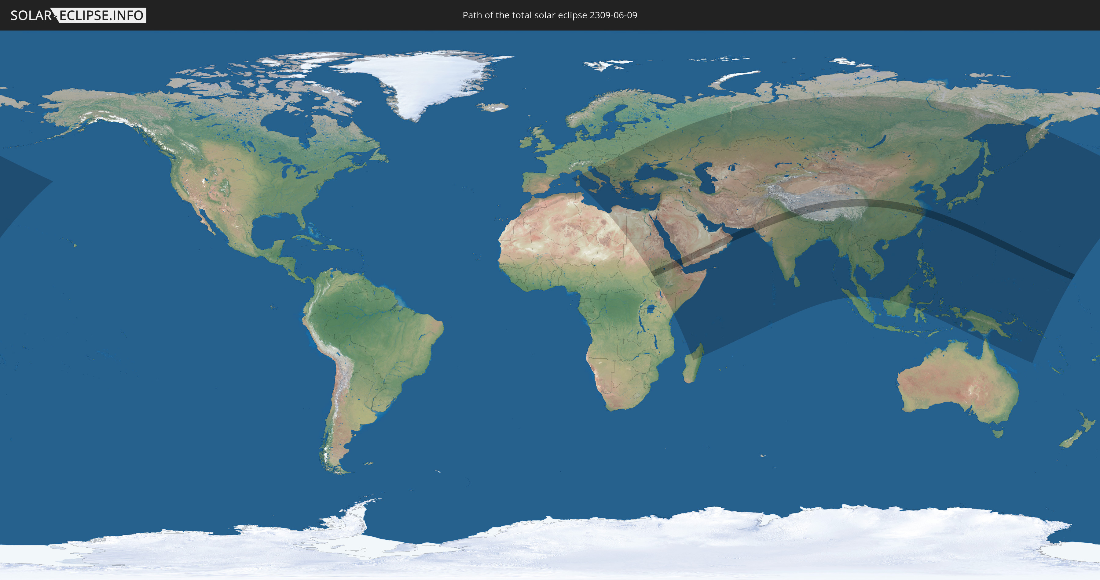
Die Sonnenfinsternis am 06/09/2309 kann man in 93 Ländern als partielle Sonnenfinsternis beobachten.
Der Finsternispfad verläuft durch 14 Länder. Nur in diesen Ländern ist sie als total Sonnenfinsternis zu sehen.
In den folgenden Ländern ist die Sonnenfinsternis total zu sehen
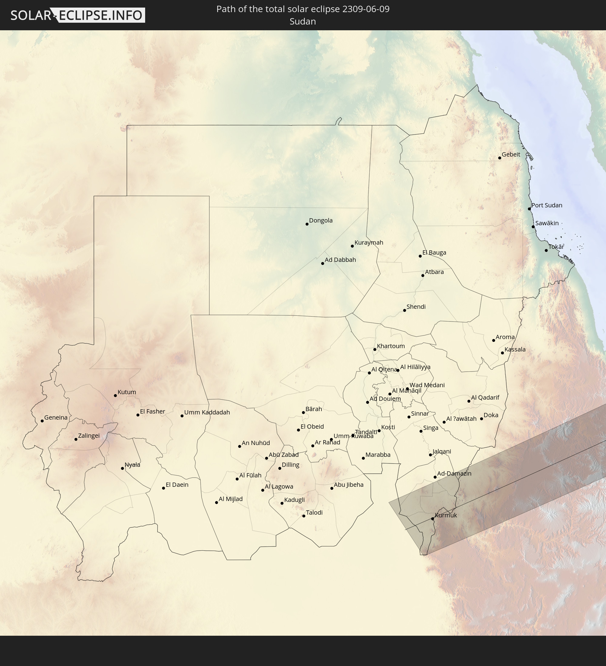 Sudan
Sudan
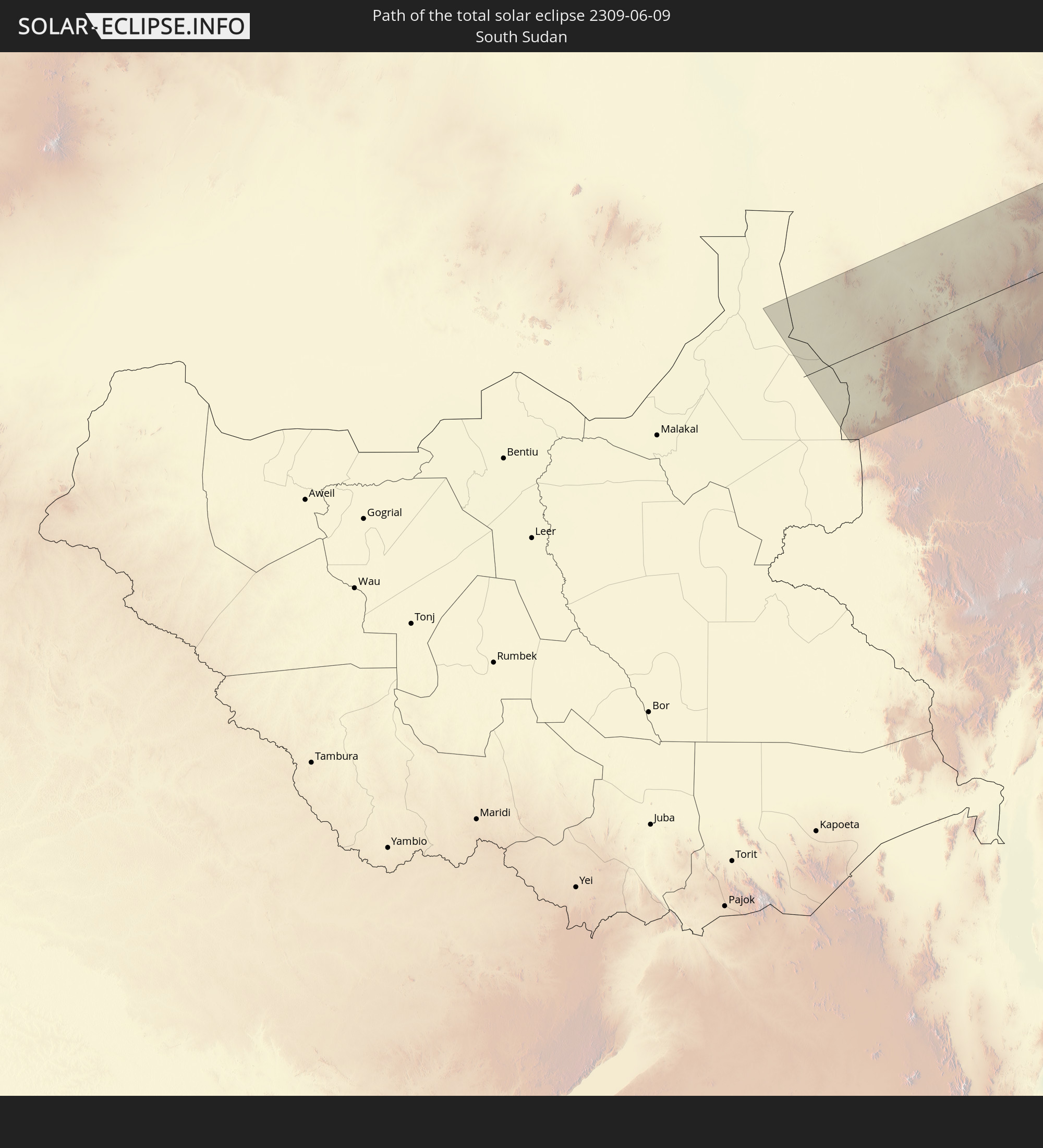 South Sudan
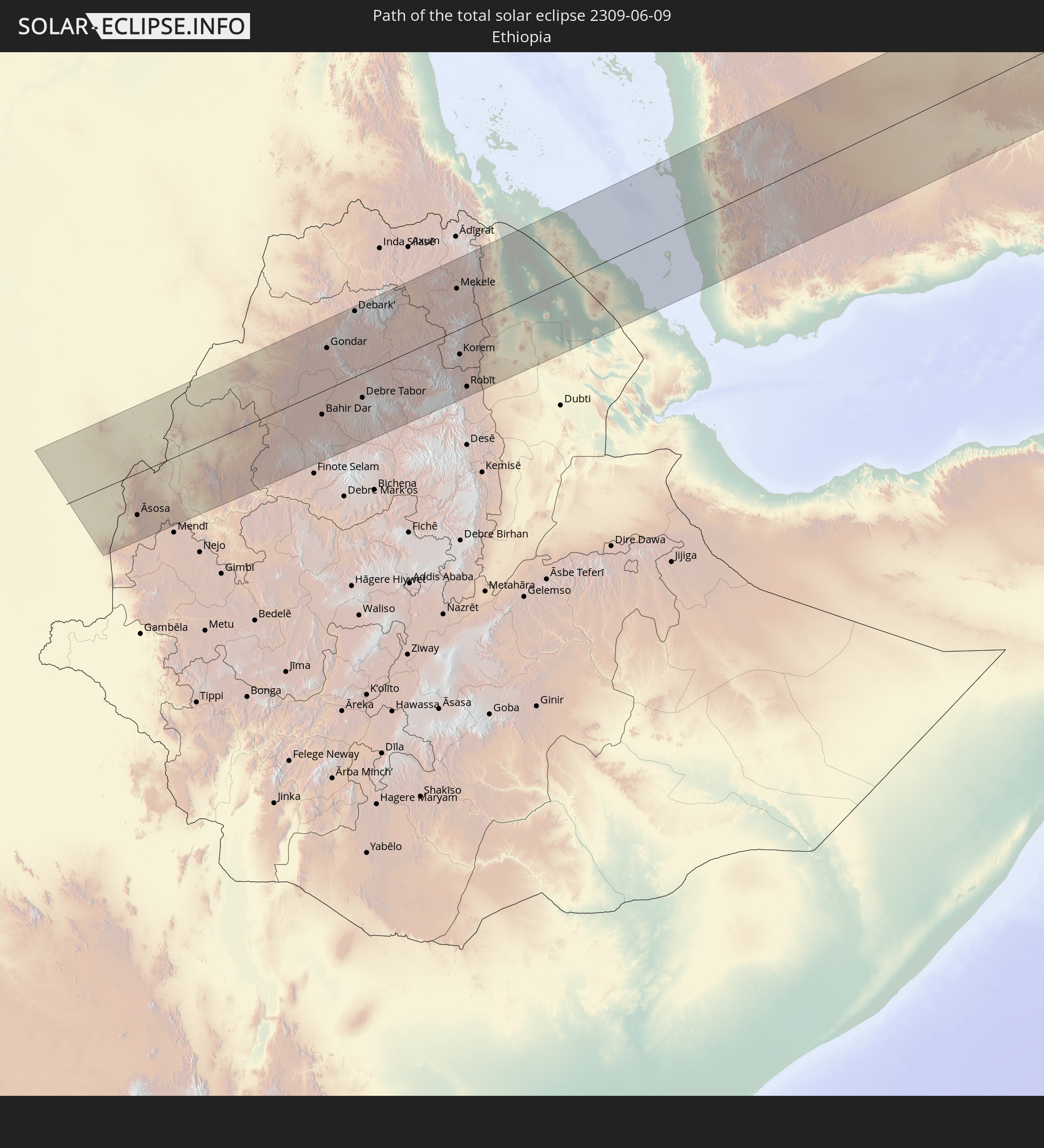 Ethiopia
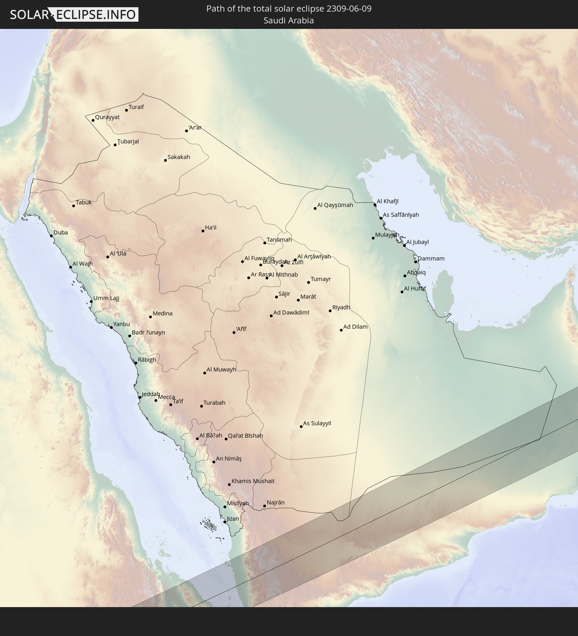 Saudi Arabia
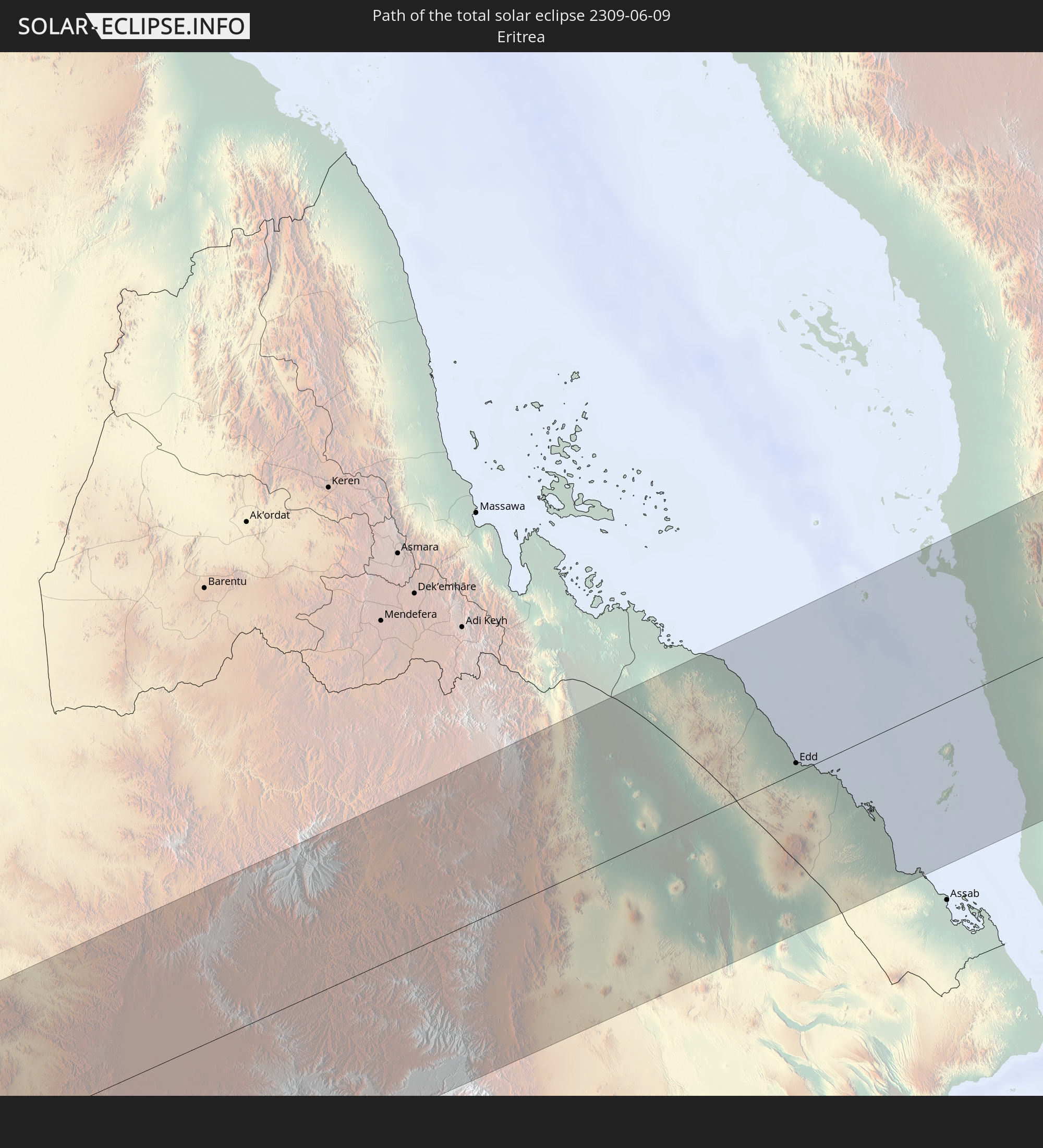 Eritrea
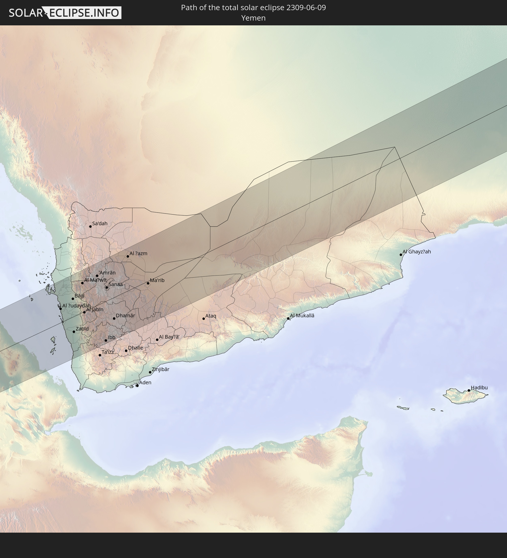 Yemen
Yemen
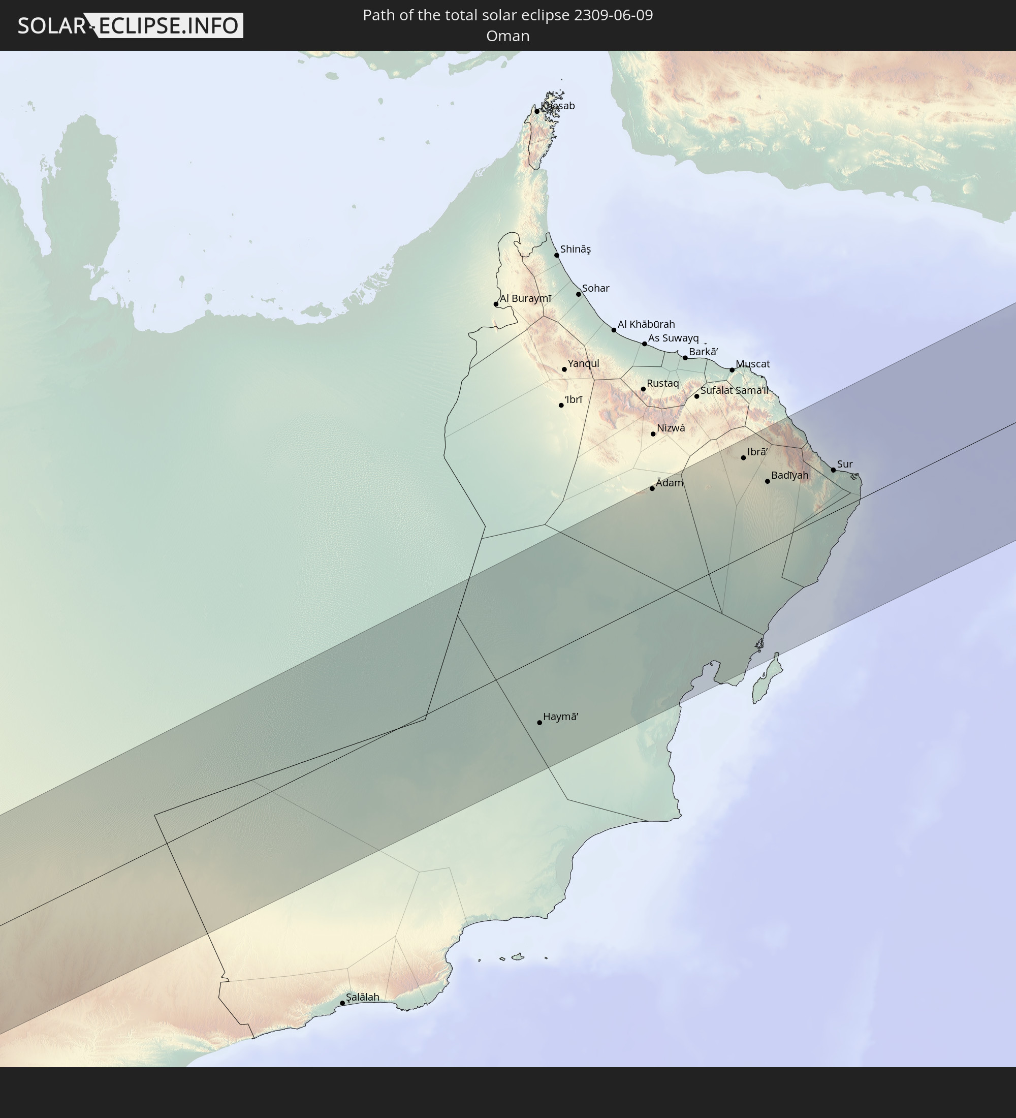 Oman
Oman
 Pakistan
 India
India
 China
China
 Nepal
Nepal
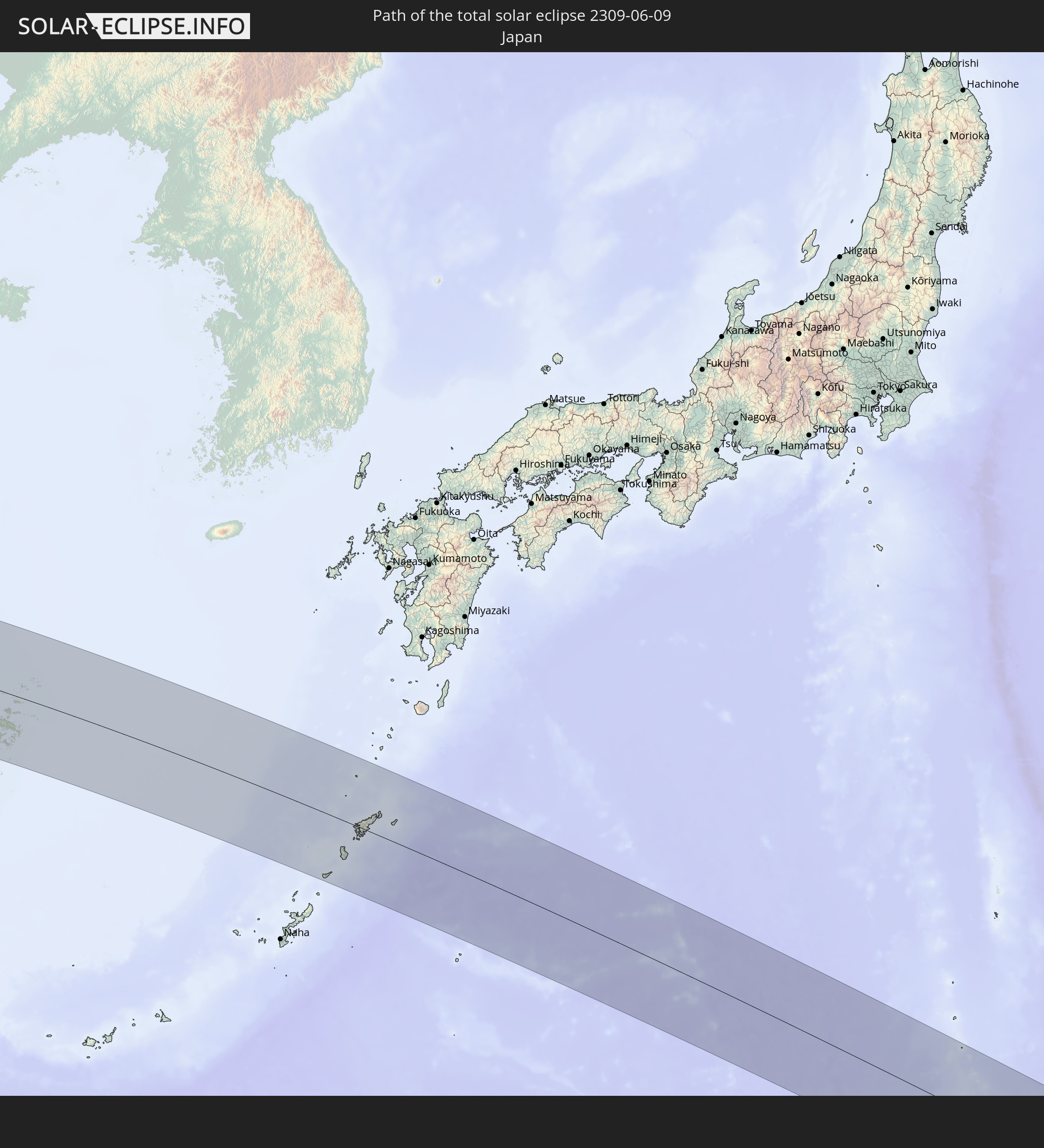 Japan
Japan
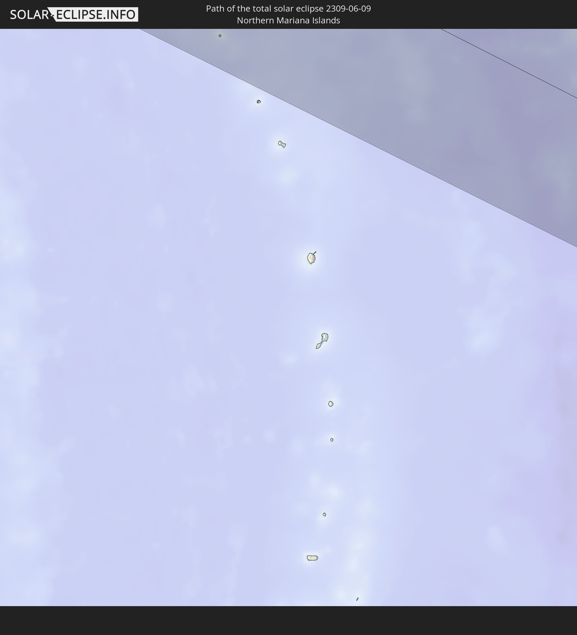 Northern Mariana Islands
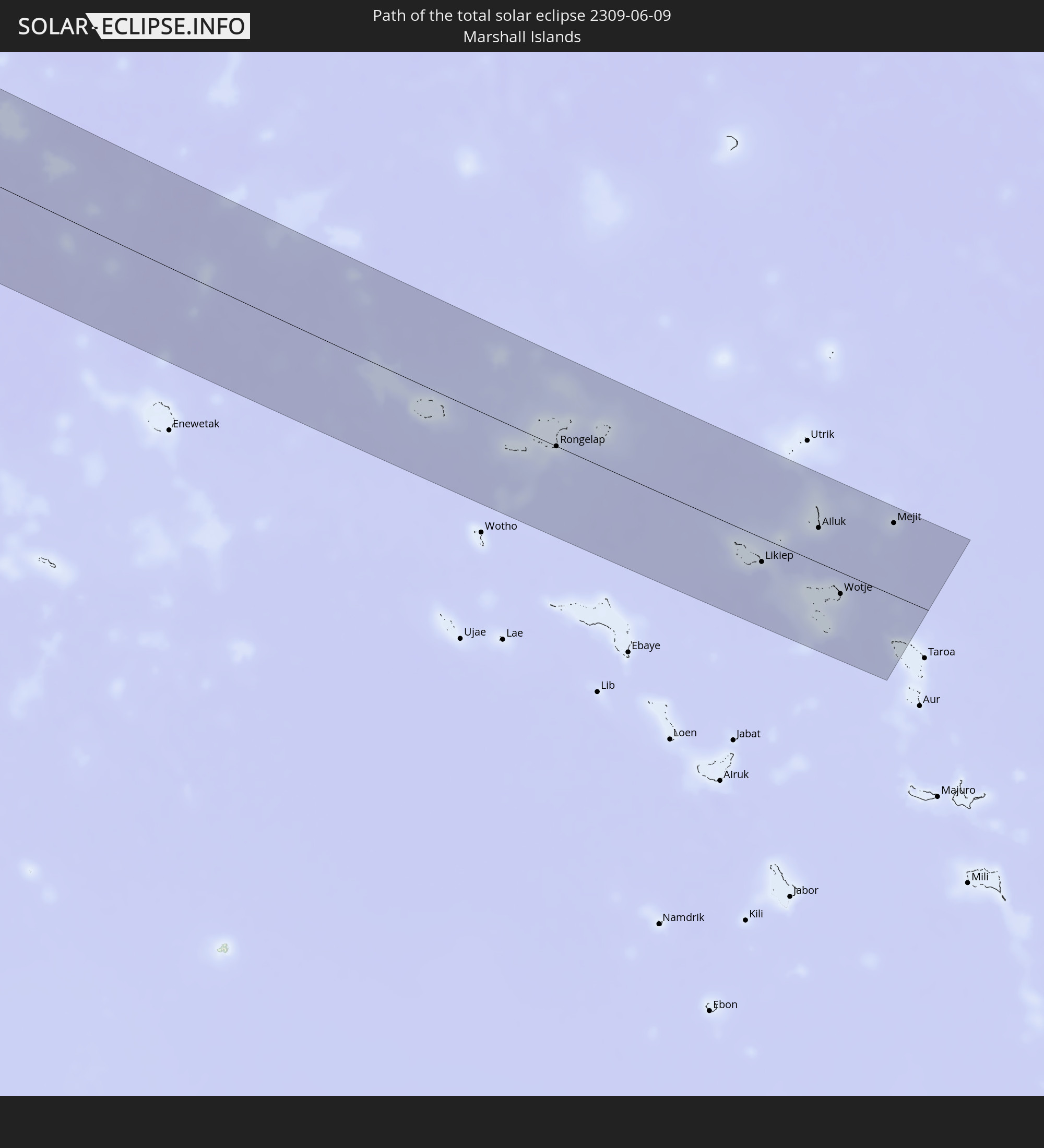 Marshall Islands
In den folgenden Ländern ist die Sonnenfinsternis partiell zu sehen
 Russia
 United States Minor Outlying Islands
 France
 Italy
Italy
 Libya
Libya
 San Marino
 Vatican City
 Croatia
 Poland
 Malta
Malta
 Bosnia and Herzegovina
 Hungary
 Slovakia
 Montenegro
 Serbia
 Albania
 Greece
 Romania
 Republic of Macedonia
 Sudan
Sudan
 Ukraine
 Bulgaria
 Belarus
 Egypt
Egypt
 Turkey
 Moldova
 Cyprus
 Ethiopia
 Kenya
Kenya
 State of Palestine
 Israel
 Saudi Arabia
 Jordan
 Lebanon
 Syria
Syria
 Eritrea
 Iraq
Iraq
 Georgia
 French Southern and Antarctic Lands
 Somalia
 Djibouti
 Yemen
Yemen
 Madagascar
 Armenia
 Iran
Iran
 Azerbaijan
 Mayotte
 Seychelles
 Kazakhstan
 Kuwait
 Bahrain
 Qatar
Qatar
 United Arab Emirates
 Oman
Oman
 Turkmenistan
 Uzbekistan
 Mauritius
 Afghanistan
 Pakistan
 Tajikistan
 India
India
 Kyrgyzstan
 British Indian Ocean Territory
 Maldives
 China
China
 Sri Lanka
 Nepal
Nepal
 Mongolia
 Bangladesh
 Bhutan
 Myanmar
 Indonesia
 Thailand
 Malaysia
 Laos
Laos
 Vietnam
 Cambodia
 Australia
 Macau
Macau
 Hong Kong
 Brunei
 Taiwan
 Philippines
 Japan
Japan
 North Korea
 South Korea
 Palau
Palau
 Federated States of Micronesia
 Papua New Guinea
 Guam
Guam
 Northern Mariana Islands
 Solomon Islands
 Marshall Islands
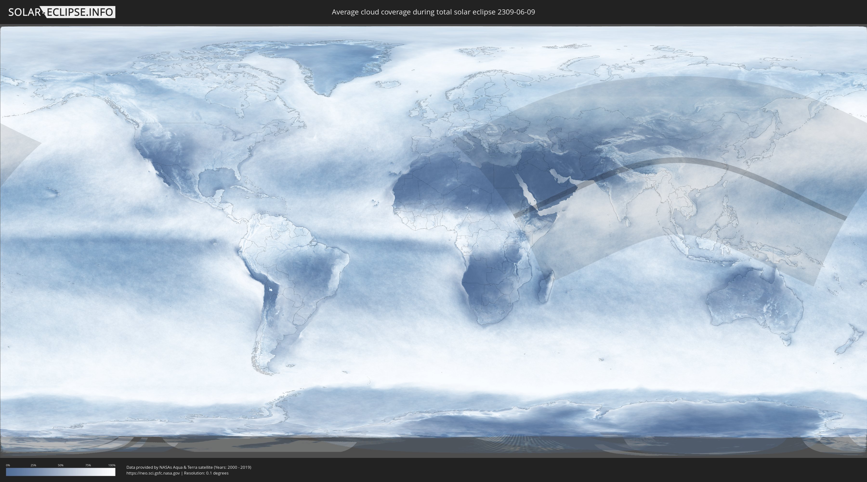
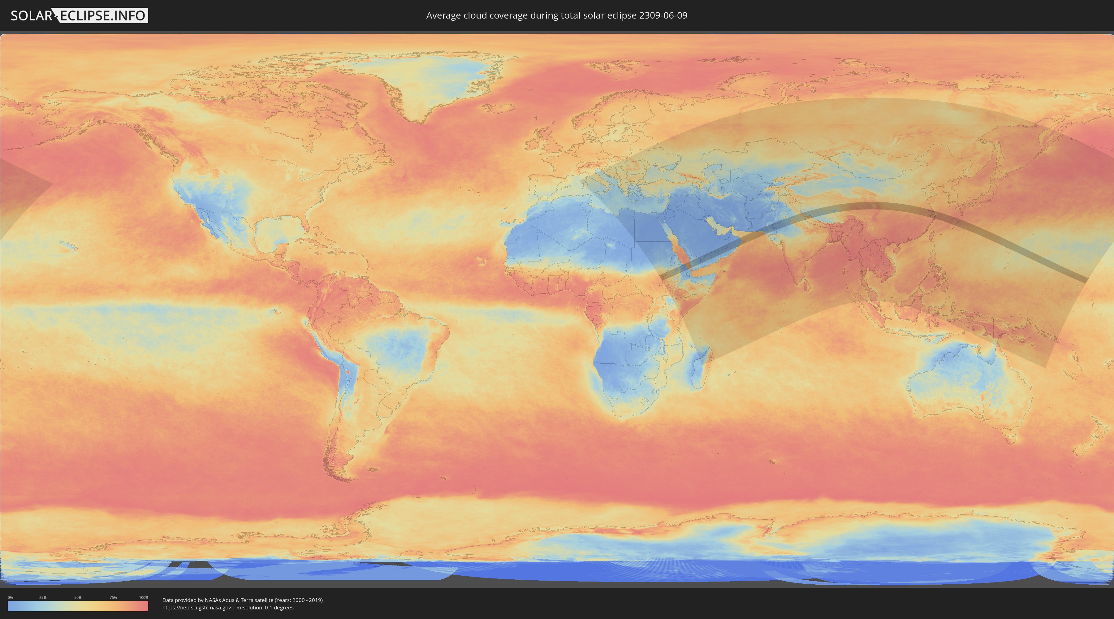
How will be the weather during the total solar eclipse on 06/09/2309?
Where is the best place to see the total solar eclipse of 06/09/2309?
The following maps show the average cloud coverage for the day of the total solar eclipse.
With the help of these maps, it is possible to find the place along the eclipse path, which has the best
chance of a cloudless sky.
Nevertheless, you should consider local circumstances and inform about the weather of your chosen
observation site.
The data is provided by NASAs satellites
AQUA and TERRA.
The cloud maps are averaged over a period of 19 years (2000 - 2019).
Detailed country maps
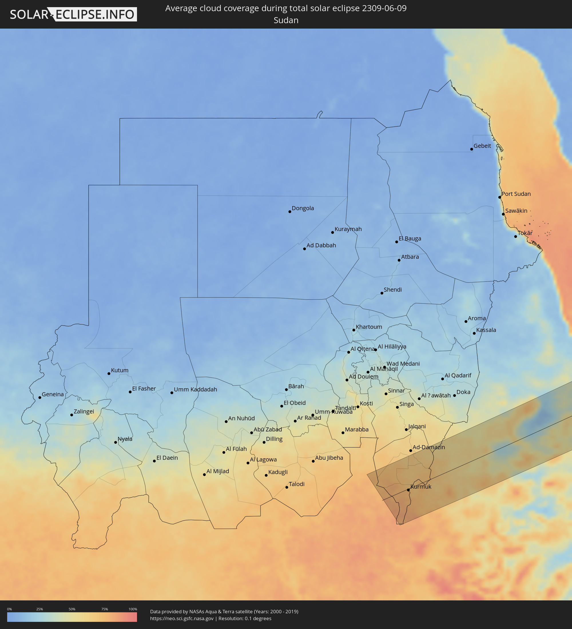 Sudan
Sudan
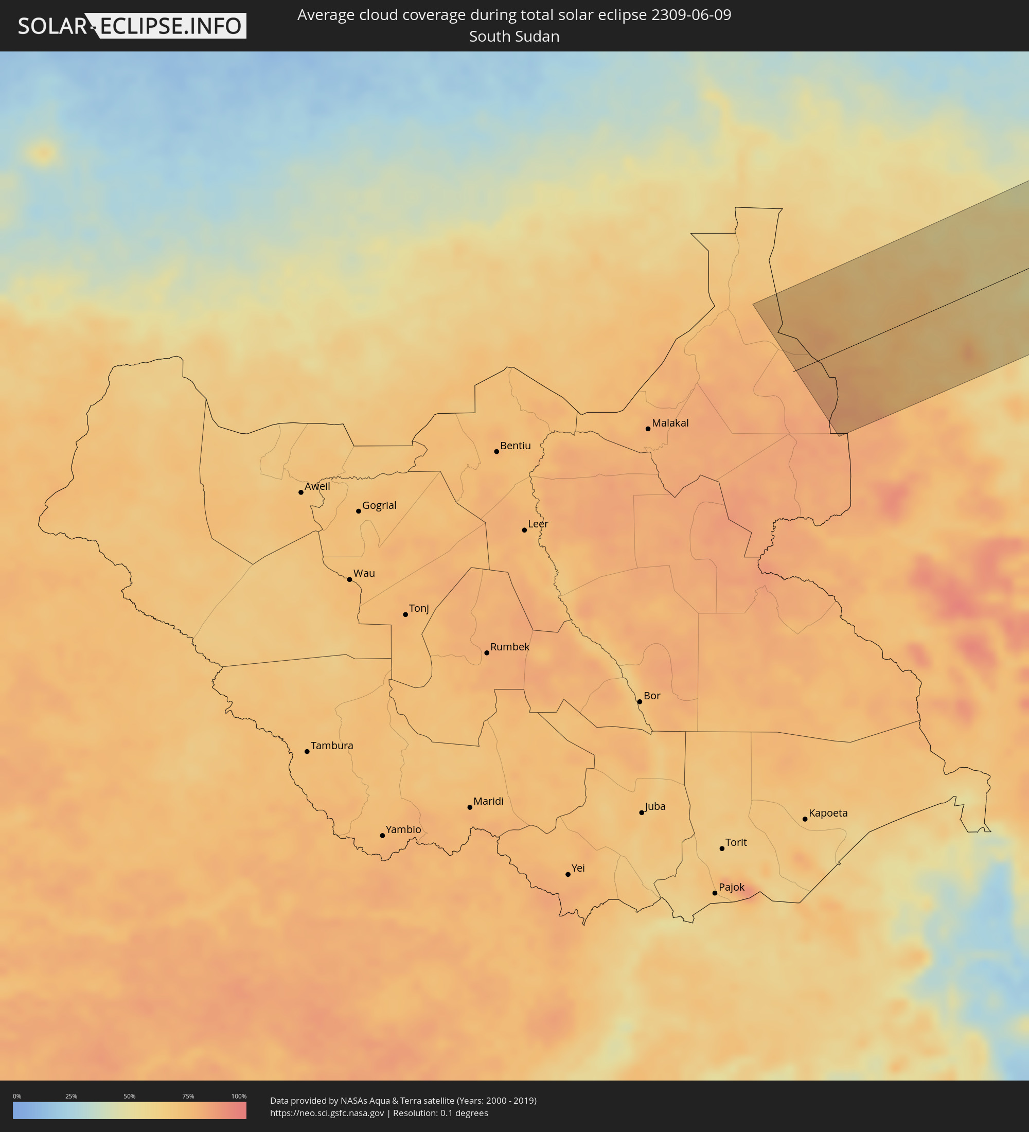 South Sudan
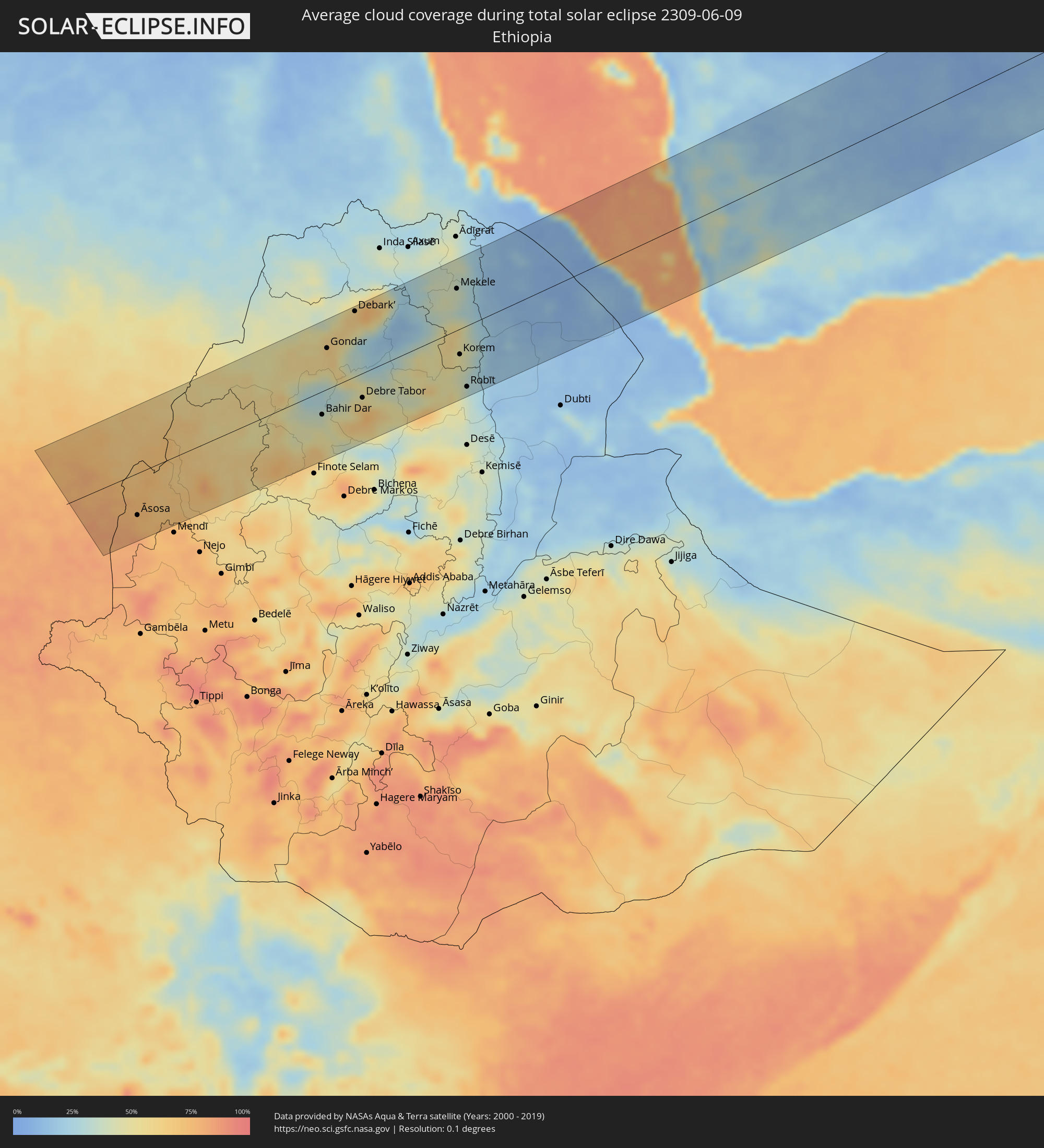 Ethiopia
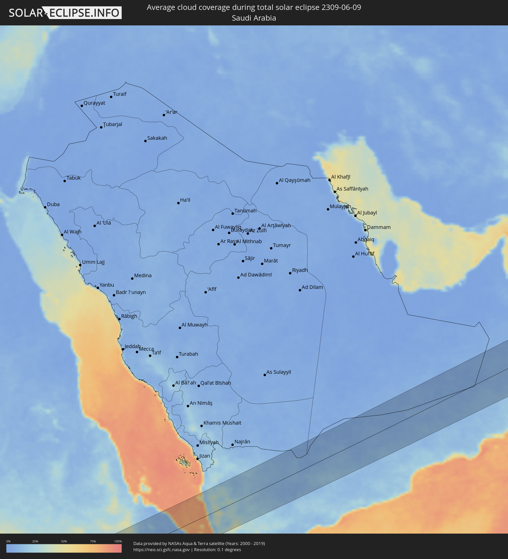 Saudi Arabia
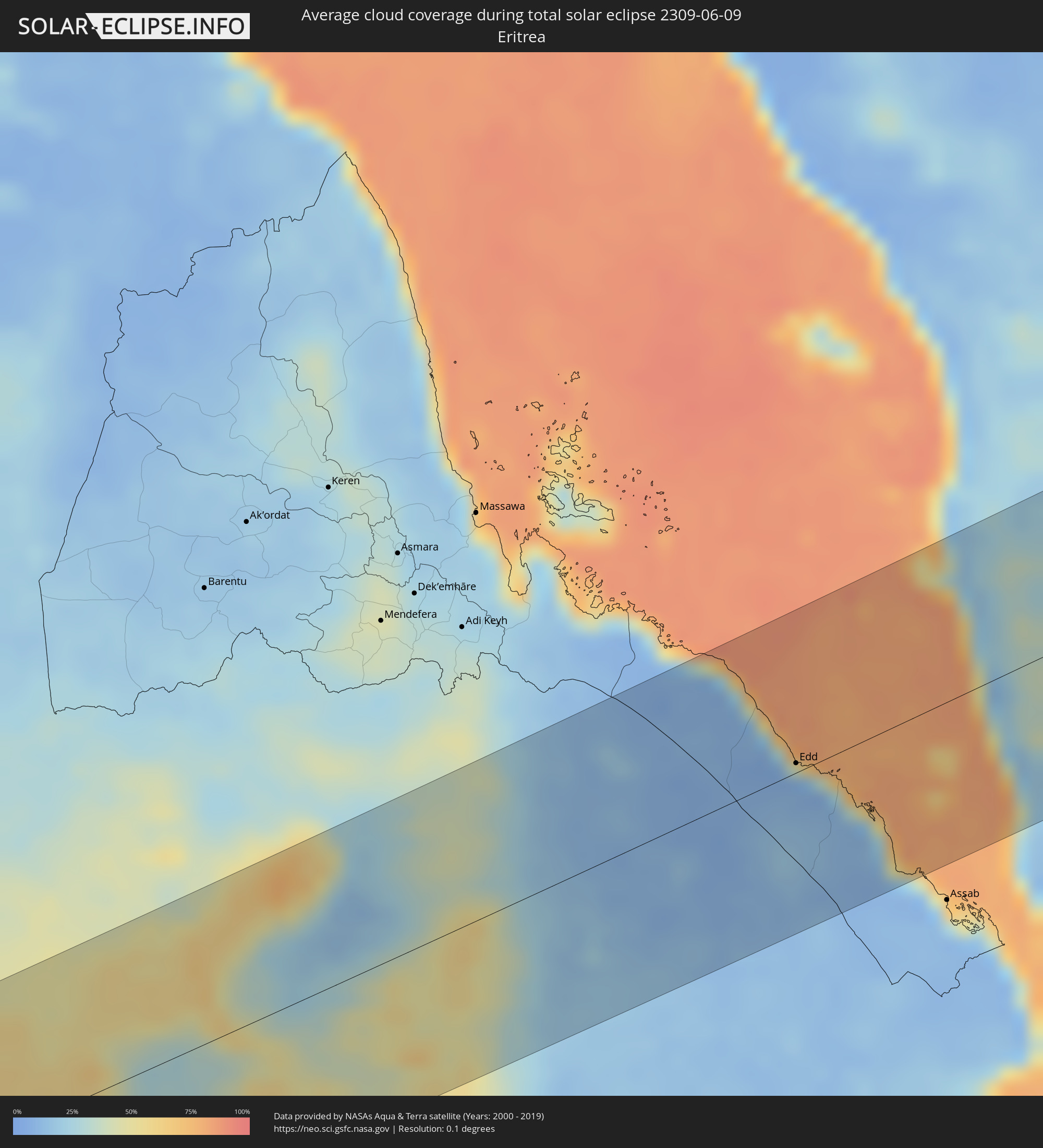 Eritrea
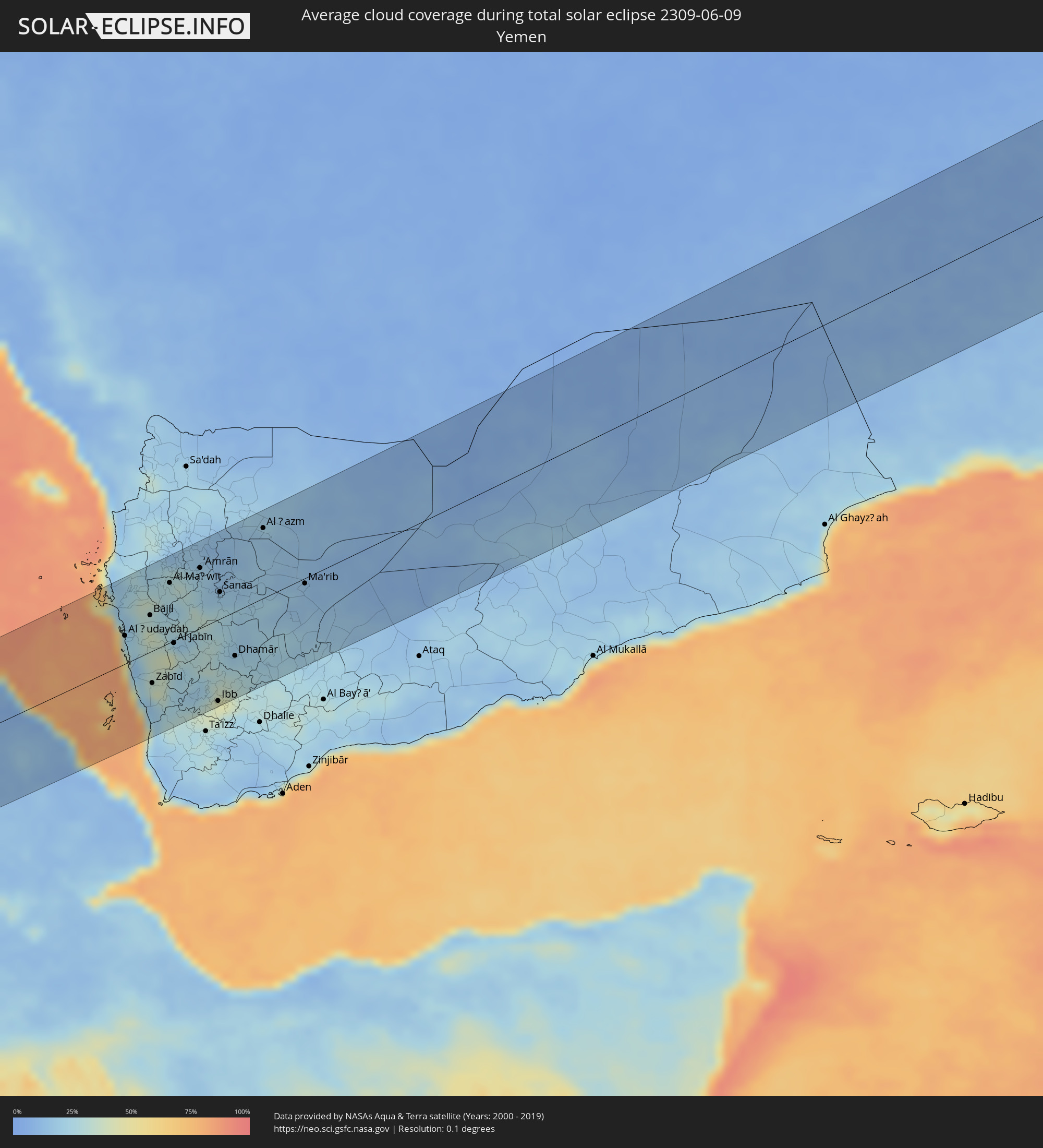 Yemen
Yemen
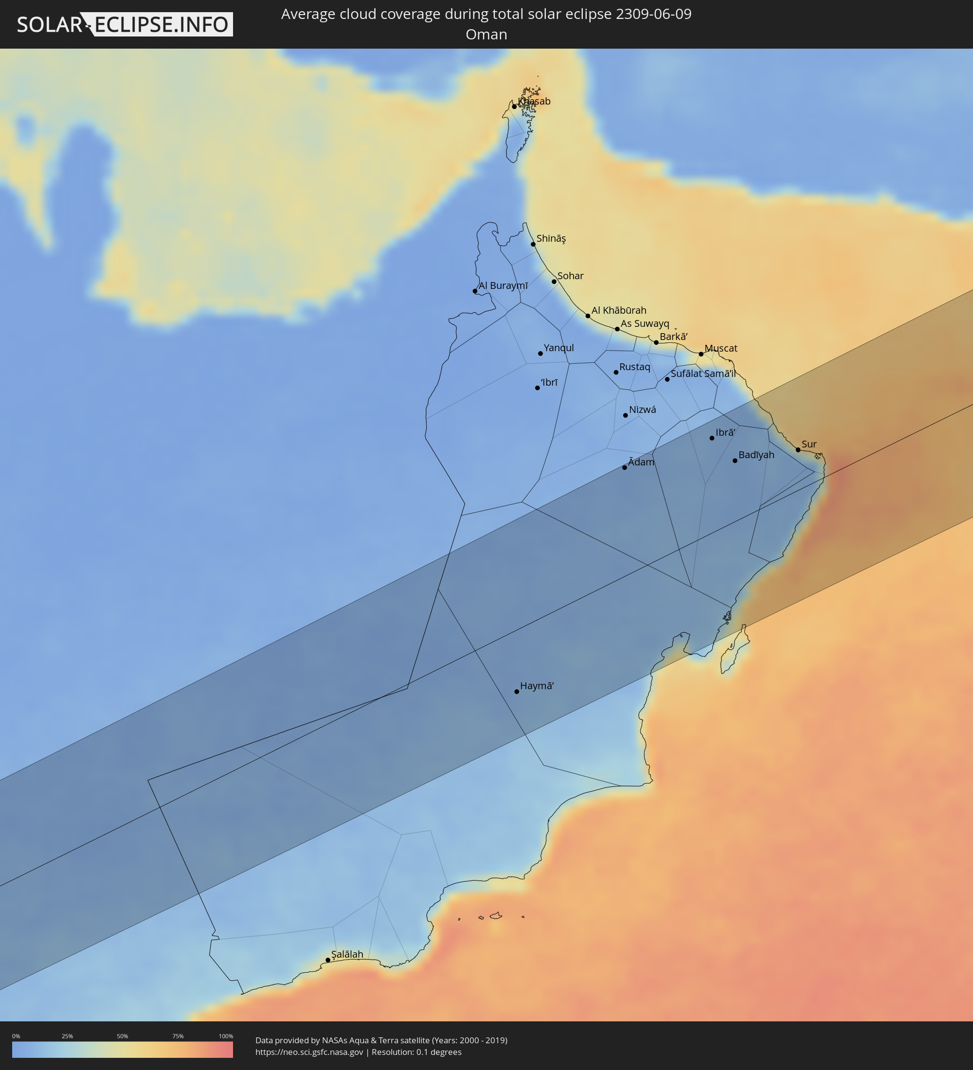 Oman
Oman
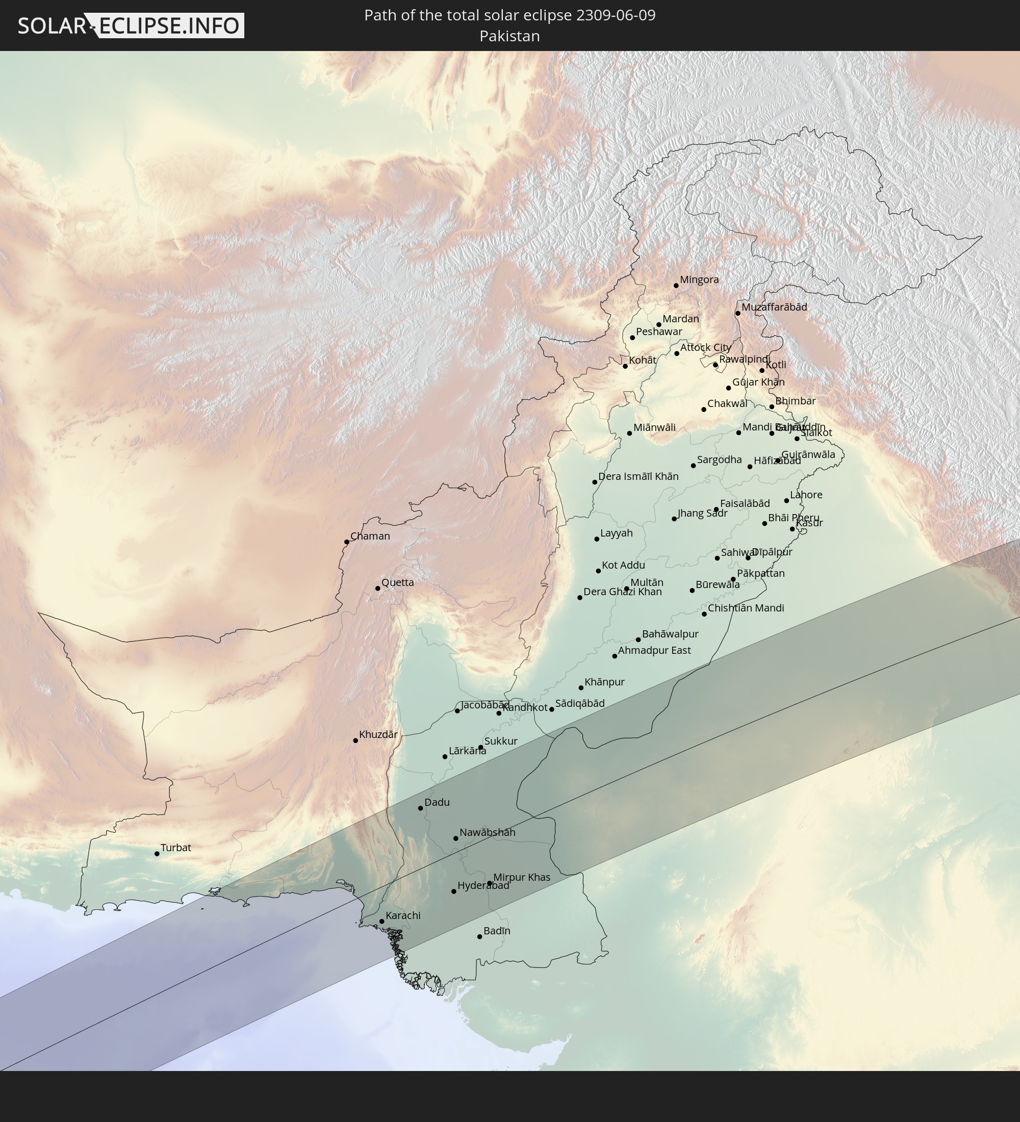
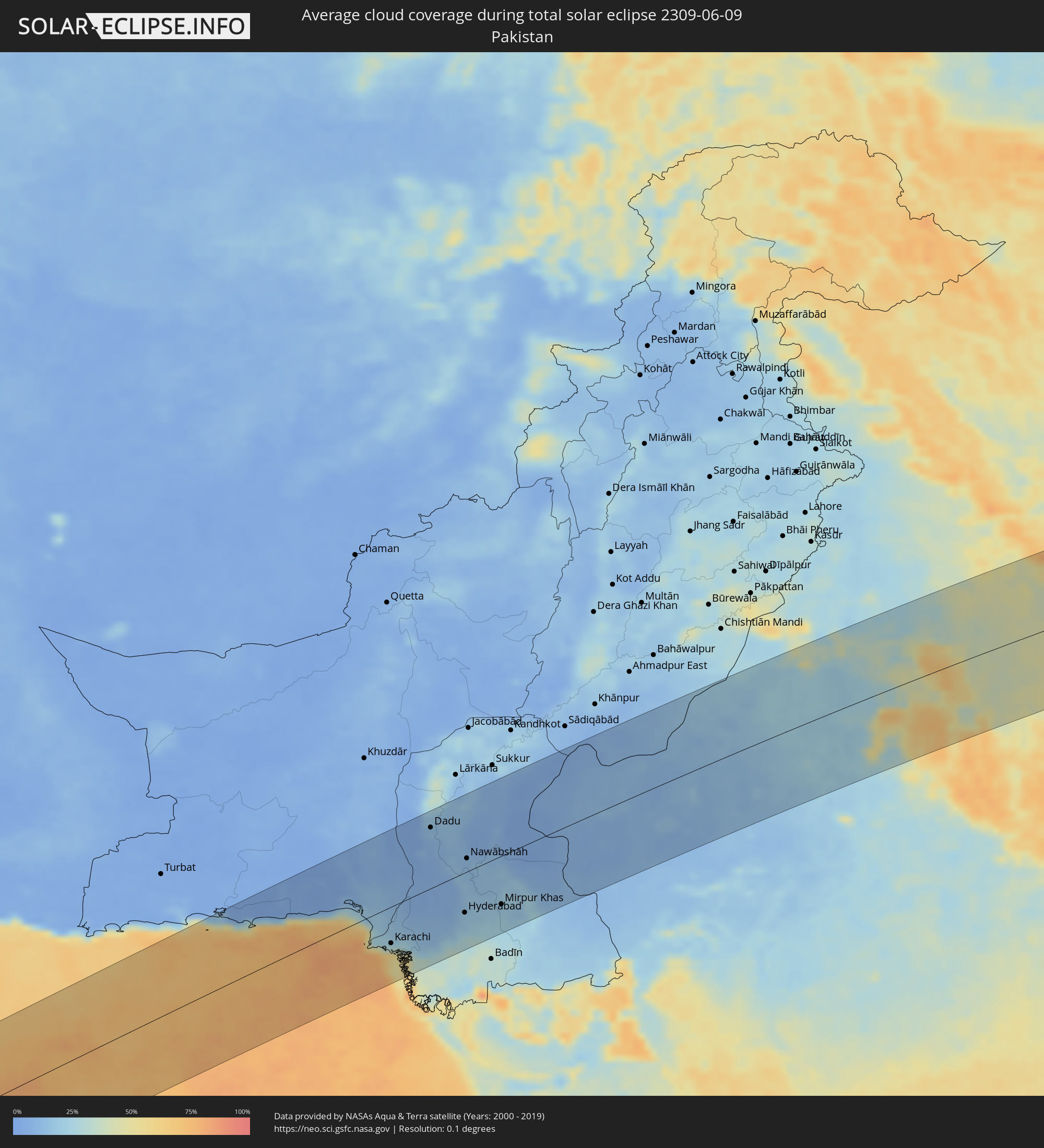 Pakistan
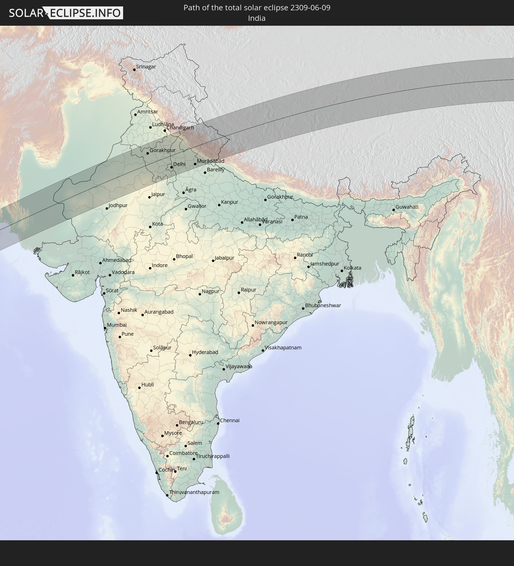
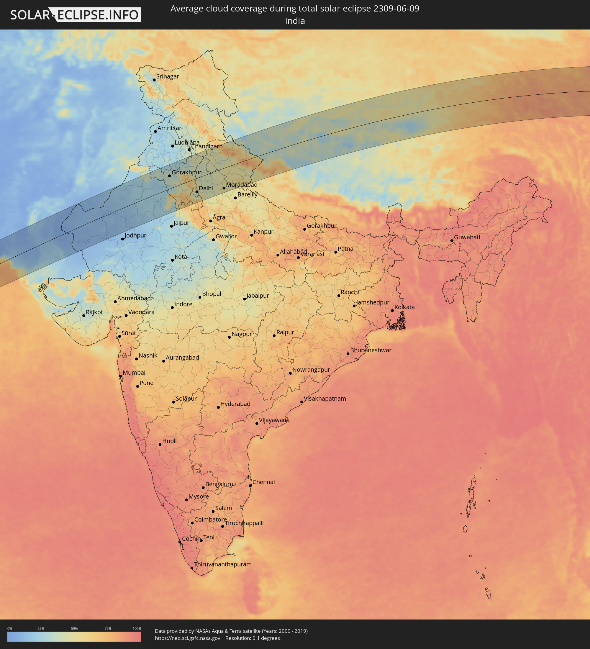 India
India
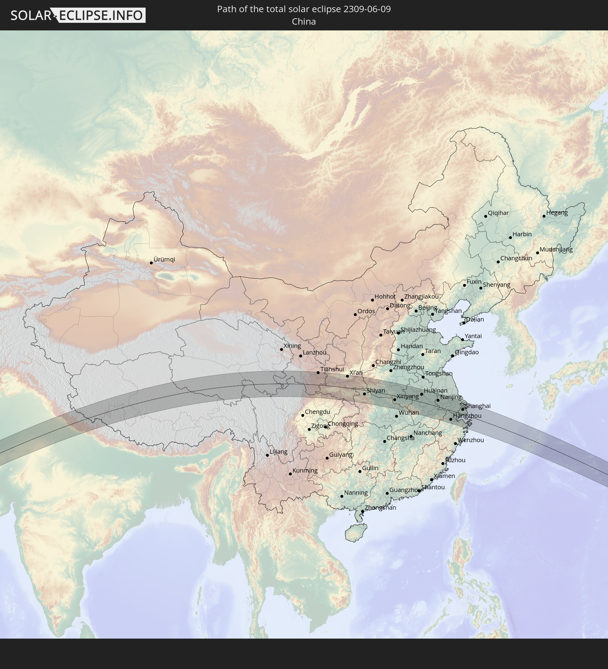
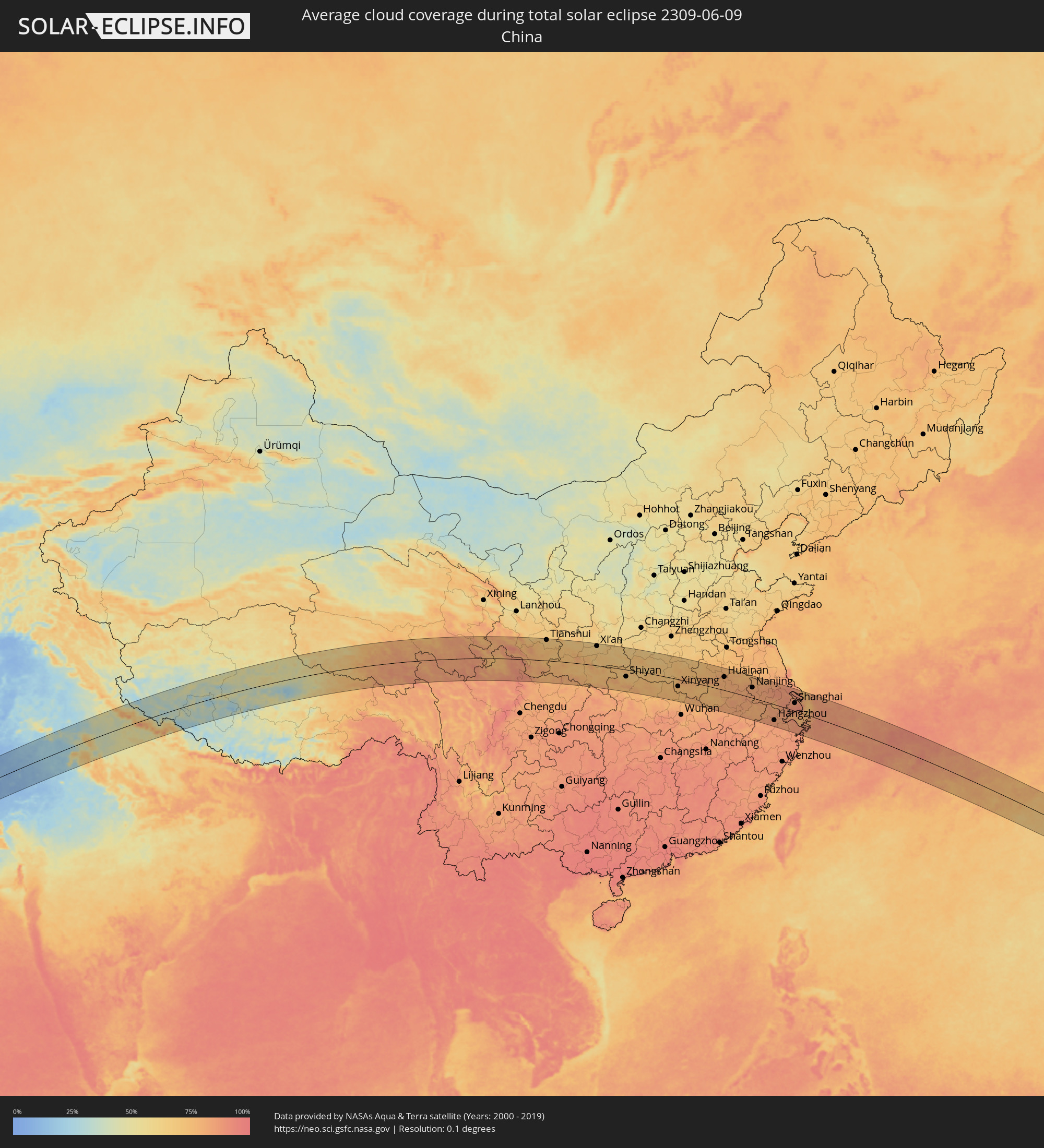 China
China
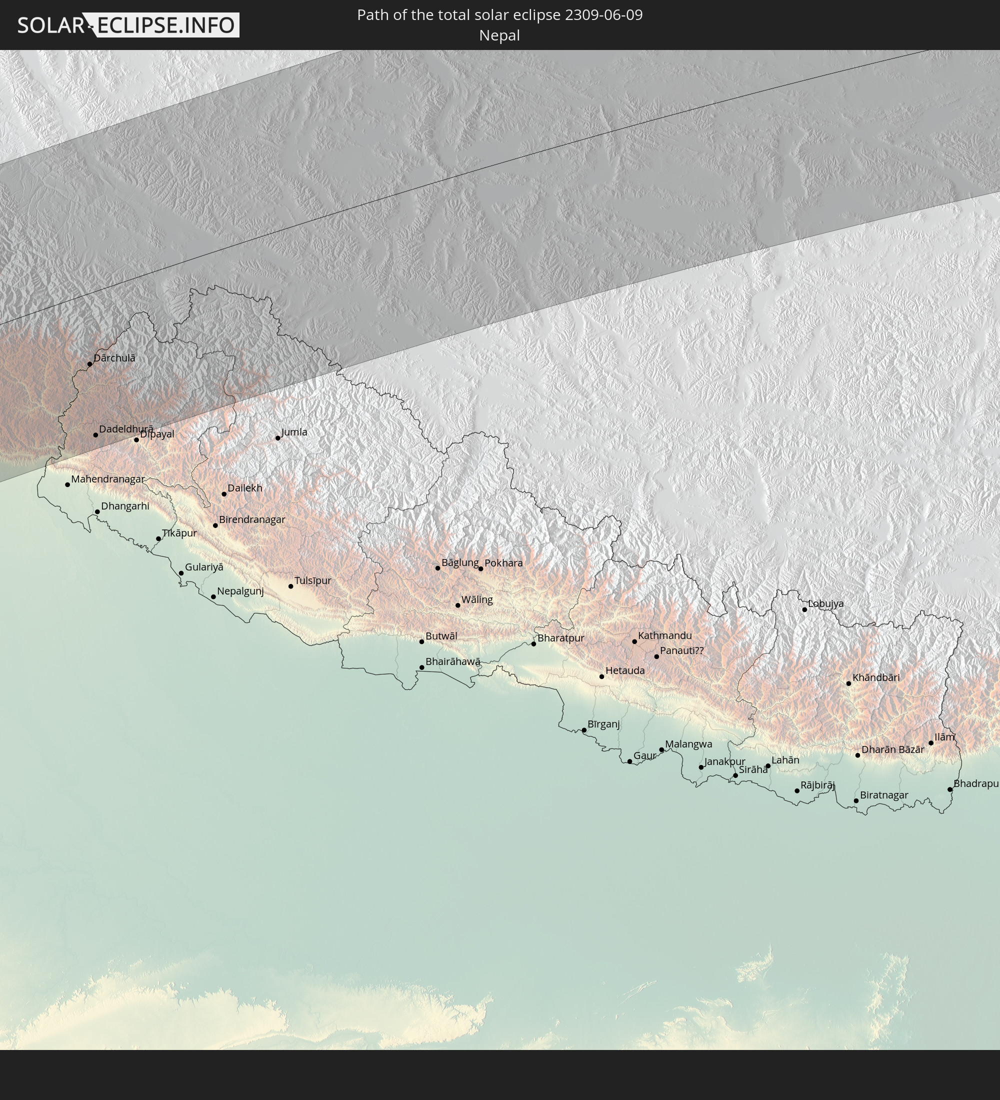
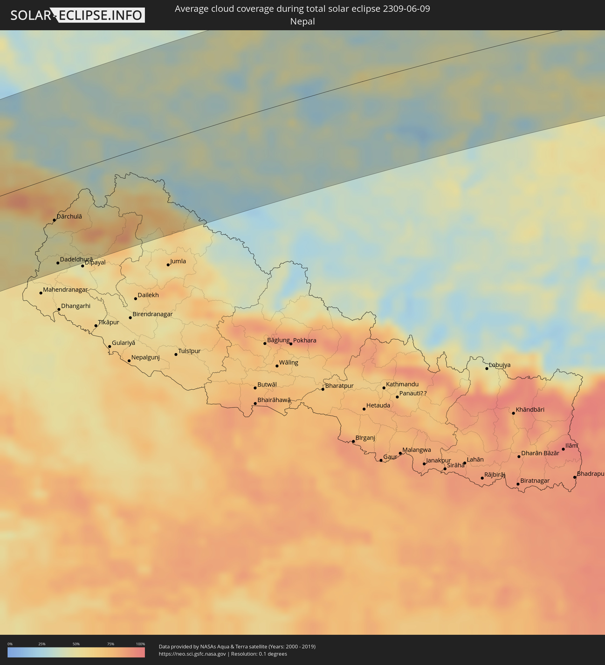 Nepal
Nepal
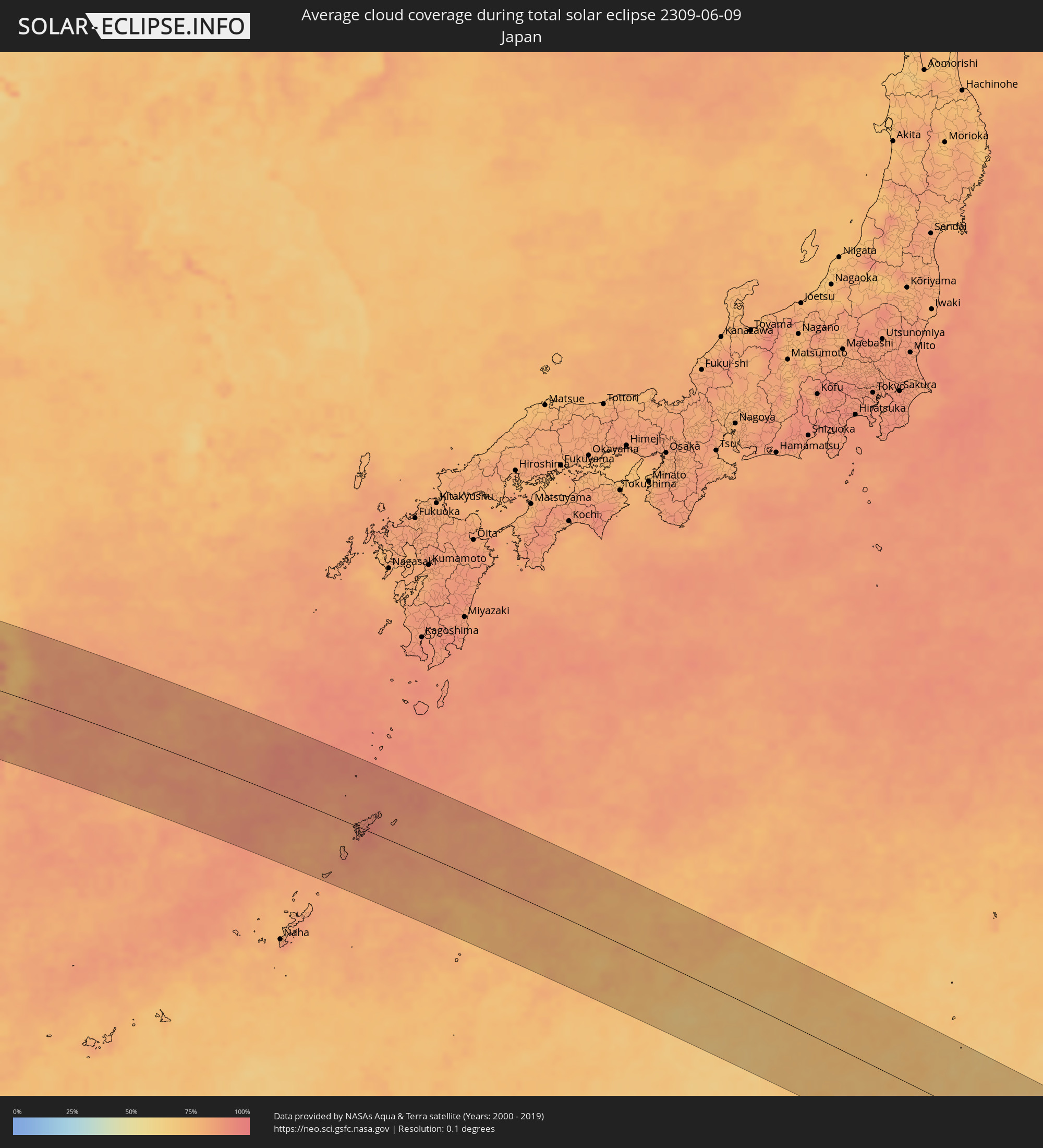 Japan
Japan
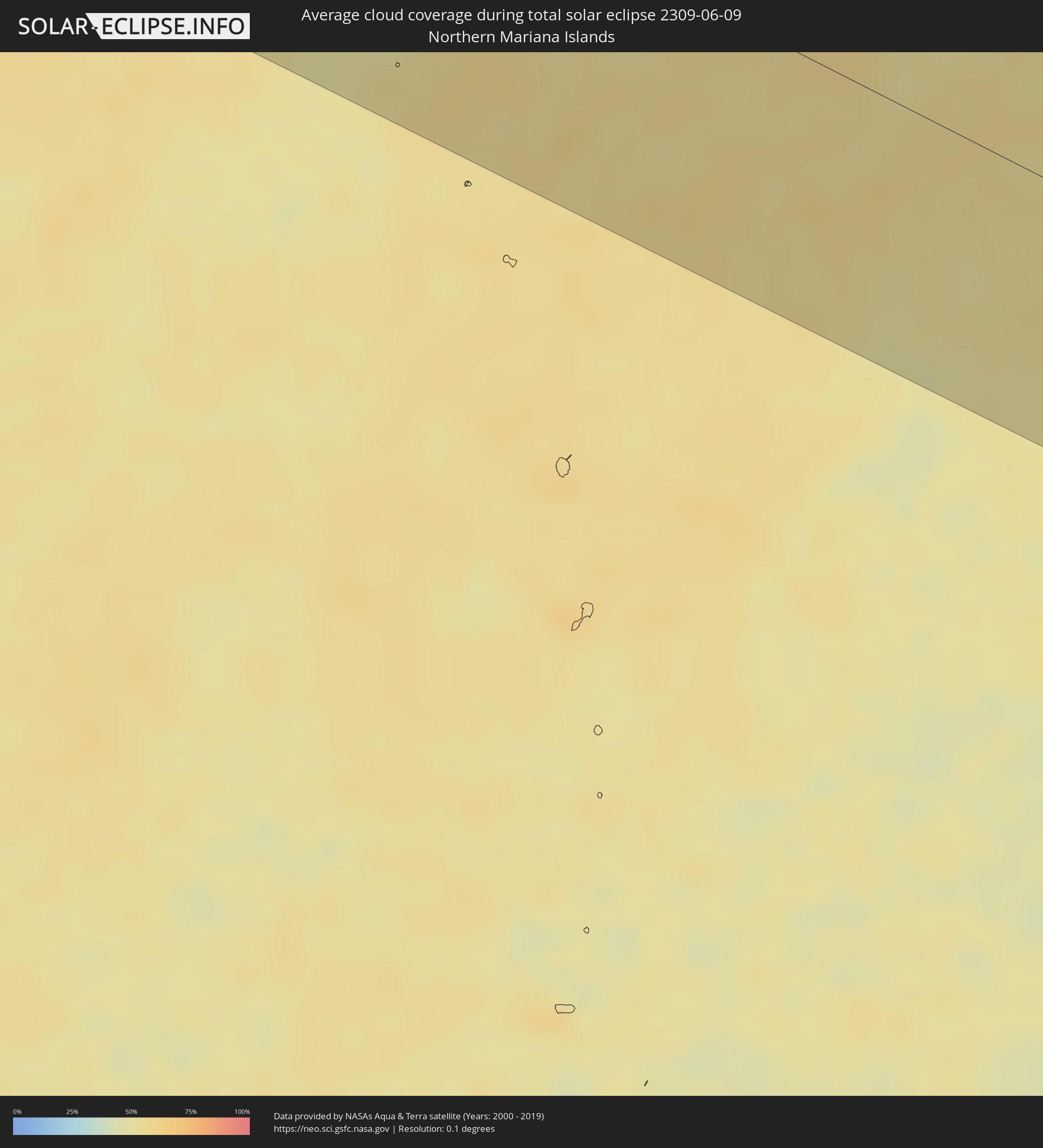 Northern Mariana Islands
 Marshall Islands
Cities inside the path of the eclipse
The following table shows all locations with a population of more than 5,000 inside the eclipse path. Cities which have more than 100,000 inhabitants are marked bold. A click at the locations opens a detailed map.
| City | Type | Eclipse duration | Local time of max. eclipse | Distance to central line | Ø Cloud coverage |
|
Kurmuk, Blue Nile
|
total | - | 05:28:31 UTC+02:00 | 5 km | 74% |
|
Āsosa, Bīnshangul Gumuz
|
total | - | 06:28:12 UTC+03:00 | 65 km | 77% |
|
Bahir Dar, Amhara
|
total | - | 06:28:37 UTC+03:00 | 36 km | 41% |
|
Gondar, Amhara
|
total | - | 06:29:14 UTC+03:00 | 63 km | 64% |
|
Addiet Canna, Amhara
|
total | - | 06:28:25 UTC+03:00 | 73 km | 51% |
|
Werota, Amhara
|
total | - | 06:28:47 UTC+03:00 | 17 km | 38% |
|
Dabat, Amhara
|
total | - | 06:29:26 UTC+03:00 | 89 km | 62% |
|
Ādīs Zemen, Amhara
|
total | - | 06:28:53 UTC+03:00 | 0 km | 39% |
|
Debark’, Amhara
|
total | - | 06:29:32 UTC+03:00 | 100 km | 61% |
|
Debre Tabor, Amhara
|
total | - | 06:28:42 UTC+03:00 | 38 km | 57% |
|
Lalībela, Amhara
|
total | - | 06:28:43 UTC+03:00 | 66 km | 47% |
|
Mekele, Tigray
|
total | - | 06:29:39 UTC+03:00 | 63 km | 40% |
|
Korem, Tigray
|
total | - | 06:29:00 UTC+03:00 | 39 km | 49% |
|
Maych’ew, Tigray
|
total | - | 06:29:11 UTC+03:00 | 11 km | 55% |
|
Robīt, Amhara
|
total | - | 06:28:41 UTC+03:00 | 94 km | 40% |
|
Edd, Southern Red Sea
|
total | - | 06:29:54 UTC+03:00 | 6 km | 10% |
|
Al Ḩudaydah, Muḩāfaz̧at al Ḩudaydah
|
total | - | 06:30:35 UTC+03:00 | 36 km | 28% |
|
Bājil, Muḩāfaz̧at al Ḩudaydah
|
total | - | 06:30:47 UTC+03:00 | 47 km | 32% |
|
Zabīd, Muḩāfaz̧at al Ḩudaydah
|
total | - | 06:30:10 UTC+03:00 | 41 km | 29% |
|
Bayt al Faqīh, Muḩāfaz̧at al Ḩudaydah
|
total | - | 06:30:24 UTC+03:00 | 9 km | 30% |
|
Al Maḩwīt, Al Maḩwīt
|
total | - | 06:31:07 UTC+03:00 | 76 km | 27% |
|
Al Jabīn, Raymah
|
total | - | 06:30:33 UTC+03:00 | 3 km | 40% |
|
Ḩajjah, Ḩajjah
|
total | - | 06:31:18 UTC+03:00 | 96 km | 28% |
|
‘Amrān, Omran
|
total | - | 06:31:18 UTC+03:00 | 77 km | 22% |
|
Ibb, Ibb
|
total | - | 06:30:04 UTC+03:00 | 104 km | 42% |
|
Sanaa, Sanaa
|
total | - | 06:31:06 UTC+03:00 | 34 km | 20% |
|
Saḩar, Sanaa
|
total | - | 06:31:04 UTC+03:00 | 26 km | 26% |
|
Sayyān, Sanaa
|
total | - | 06:30:58 UTC+03:00 | 10 km | 25% |
|
Yarīm, Ibb
|
total | - | 06:30:20 UTC+03:00 | 80 km | 33% |
|
Dhamār, Dhamār
|
total | - | 06:30:30 UTC+03:00 | 57 km | 27% |
|
Al Ḩazm, Al Jawf
|
total | - | 06:31:47 UTC+03:00 | 89 km | 19% |
|
Ma'rib, Ma’rib
|
total | - | 06:31:19 UTC+03:00 | 7 km | 15% |
|
Haymā’, Al Wusţá
|
total | - | 07:39:03 UTC+04:00 | 68 km | 10% |
|
Ādam, Muḩāfaz̧at ad Dākhilīyah
|
total | - | 07:42:15 UTC+04:00 | 115 km | 6% |
|
Ibrā’, Ash Sharqiyah North Governorate
|
total | - | 07:43:15 UTC+04:00 | 100 km | 10% |
|
Al Qābil, Ash Sharqiyah North Governorate
|
total | - | 07:43:14 UTC+04:00 | 81 km | 8% |
|
Badīyah, Ash Sharqiyah North Governorate
|
total | - | 07:43:11 UTC+04:00 | 64 km | 7% |
|
Sur, Ash Sharqiyah South Governorate
|
total | - | 07:43:49 UTC+04:00 | 42 km | 18% |
|
Karachi, Sindh
|
total | - | 08:53:16 UTC+05:00 | 58 km | 34% |
|
Dadu, Sindh
|
total | - | 08:56:07 UTC+05:00 | 97 km | 14% |
|
Sehwān, Sindh
|
total | - | 08:55:52 UTC+05:00 | 62 km | 9% |
|
Thatta, Sindh
|
total | - | 08:54:03 UTC+05:00 | 110 km | 31% |
|
Moro, Sindh
|
total | - | 08:56:18 UTC+05:00 | 80 km | 14% |
|
Sakrand, Sindh
|
total | - | 08:56:01 UTC+05:00 | 16 km | 16% |
|
Hyderabad, Sindh
|
total | - | 08:55:17 UTC+05:00 | 64 km | 18% |
|
Nawābshāh, Sindh
|
total | - | 08:56:18 UTC+05:00 | 21 km | 14% |
|
Hāla, Sindh
|
total | - | 08:55:49 UTC+05:00 | 23 km | 16% |
|
Sethārja Old, Sindh
|
total | - | 08:57:28 UTC+05:00 | 116 km | 14% |
|
Tando Muhammad Khān, Sindh
|
total | - | 08:55:10 UTC+05:00 | 98 km | 28% |
|
Tando Jām, Sindh
|
total | - | 08:55:31 UTC+05:00 | 67 km | 19% |
|
Shāhdādpur, Sindh
|
total | - | 08:56:11 UTC+05:00 | 20 km | 15% |
|
Mātli, Sindh
|
total | - | 08:55:14 UTC+05:00 | 111 km | 31% |
|
Tando Ādam, Sindh
|
total | - | 08:56:03 UTC+05:00 | 38 km | 15% |
|
Tando Allāhyār, Sindh
|
total | - | 08:55:46 UTC+05:00 | 71 km | 19% |
|
Sānghar, Sindh
|
total | - | 08:56:42 UTC+05:00 | 22 km | 16% |
|
Mirpur Khas, Sindh
|
total | - | 08:56:12 UTC+05:00 | 77 km | 21% |
|
Digri, Sindh
|
total | - | 08:55:54 UTC+05:00 | 119 km | 24% |
|
Bīkaner, Rajasthan
|
total | - | 09:34:41 UTC+05:30 | 5 km | 17% |
|
Gorakhpur, Haryana
|
total | - | 09:39:47 UTC+05:30 | 65 km | 38% |
|
Hisar, Haryana
|
total | - | 09:39:32 UTC+05:30 | 33 km | 37% |
|
Rohtak, Haryana
|
total | - | 09:40:36 UTC+05:30 | 25 km | 42% |
|
Pānīpat, Haryana
|
total | - | 09:41:45 UTC+05:30 | 13 km | 53% |
|
Karnāl, Haryana
|
total | - | 09:42:06 UTC+05:30 | 44 km | 39% |
|
Sonīpat, Haryana
|
total | - | 09:41:24 UTC+05:30 | 30 km | 61% |
|
Delhi, NCT
|
total | - | 09:41:23 UTC+05:30 | 73 km | 36% |
|
Yamunānagar, Haryana
|
total | - | 09:43:04 UTC+05:30 | 79 km | 40% |
|
Farīdābād, Haryana
|
total | - | 09:41:15 UTC+05:30 | 101 km | 46% |
|
Ghāziābād, Uttar Pradesh
|
total | - | 09:41:44 UTC+05:30 | 79 km | 43% |
|
Greater Noida, Uttar Pradesh
|
total | - | 09:41:43 UTC+05:30 | 100 km | 60% |
|
Sahāranpur, Uttar Pradesh
|
total | - | 09:43:19 UTC+05:30 | 53 km | 40% |
|
Muzaffarnagar, Uttar Pradesh
|
total | - | 09:43:02 UTC+05:30 | 4 km | 39% |
|
Meerut, Uttar Pradesh
|
total | - | 09:42:31 UTC+05:30 | 55 km | 38% |
|
Hāpur, Uttar Pradesh
|
total | - | 09:42:22 UTC+05:30 | 84 km | 41% |
|
Dehra Dūn, Uttarakhand
|
total | - | 09:44:30 UTC+05:30 | 74 km | 47% |
|
Morādābād, Uttar Pradesh
|
total | - | 09:44:10 UTC+05:30 | 106 km | 48% |
|
Rāmpur, Uttar Pradesh
|
total | - | 09:44:35 UTC+05:30 | 117 km | 49% |
|
Dārchulā, Western Region
|
total | - | 09:48:18 UTC+05:30 | 57 km | 48% |
|
Dadeldhurā, Far Western
|
total | - | 10:02:51 UTC+05:45 | 116 km | 56% |
|
Tianshui, Gansu
|
total | - | 13:16:34 UTC+08:00 | 120 km | 66% |
|
Xianyang, Shaanxi
|
total | - | 13:23:25 UTC+08:00 | 119 km | 65% |
|
Xi’an, Shaanxi
|
total | - | 13:23:58 UTC+08:00 | 113 km | 62% |
|
Shiyan, Hubei
|
total | - | 13:28:58 UTC+08:00 | 40 km | 70% |
|
Pingdingshan, Henan
|
total | - | 13:33:58 UTC+08:00 | 120 km | 68% |
|
Zhumadian, Henan
|
total | - | 13:36:04 UTC+08:00 | 51 km | 74% |
|
Xinyang, Henan
|
total | - | 13:36:45 UTC+08:00 | 41 km | 75% |
|
Huainan, Anhui
|
total | - | 13:42:39 UTC+08:00 | 77 km | 79% |
|
Hefei, Anhui
|
total | - | 13:43:53 UTC+08:00 | 1 km | 77% |
|
Nanjing, Jiangsu
|
total | - | 13:46:47 UTC+08:00 | 60 km | 79% |
|
Changzhou, Jiangsu
|
total | - | 13:49:23 UTC+08:00 | 61 km | 85% |
|
Hangzhou, Zhejiang
|
total | - | 13:51:12 UTC+08:00 | 91 km | 84% |
|
Wuxi, Jiangsu
|
total | - | 13:50:14 UTC+08:00 | 48 km | 83% |
|
Suzhou, Jiangsu
|
total | - | 13:51:06 UTC+08:00 | 29 km | 87% |
|
Changshu City, Jiangsu
|
total | - | 13:51:03 UTC+08:00 | 69 km | 86% |
|
Shangyu, Zhejiang
|
total | - | 13:52:53 UTC+08:00 | 100 km | 84% |
|
Nantong, Jiangsu
|
total | - | 13:50:56 UTC+08:00 | 114 km | 86% |
|
Shanghai, Shanghai
|
total | - | 13:52:50 UTC+08:00 | 45 km | 88% |
|
Ningbo, Zhejiang
|
total | - | 13:54:21 UTC+08:00 | 94 km | 86% |
|
Naze, Kagoshima
|
total | - | 15:09:47 UTC+09:00 | 21 km | 92% |
|
Rongelap, Rongelap Atoll
|
total | - | 18:50:06 UTC+12:00 | 1 km | 73% |
|
Likiep, Likiep Atoll
|
total | - | 18:50:33 UTC+12:00 | 29 km | 71% |
|
Ailuk, Ailuk Atoll
|
total | - | 18:50:12 UTC+12:00 | 41 km | 73% |
|
Wotje, Wotje Atoll
|
total | - | 18:50:35 UTC+12:00 | 26 km | 75% |
|
Mejit, Mejit Island
|
total | - | 18:49:59 UTC+12:00 | 86 km | 70% |