Total solar eclipse of 07/12/2363
| Day of week: | Friday |
| Maximum duration of eclipse: | 05m51s |
| Maximum width of eclipse path: | 279 km |
| Saros cycle: | 142 |
| Coverage: | 100% |
| Magnitude: | 1.0792 |
| Gamma: | 0.4012 |
Wo kann man die Sonnenfinsternis vom 07/12/2363 sehen?
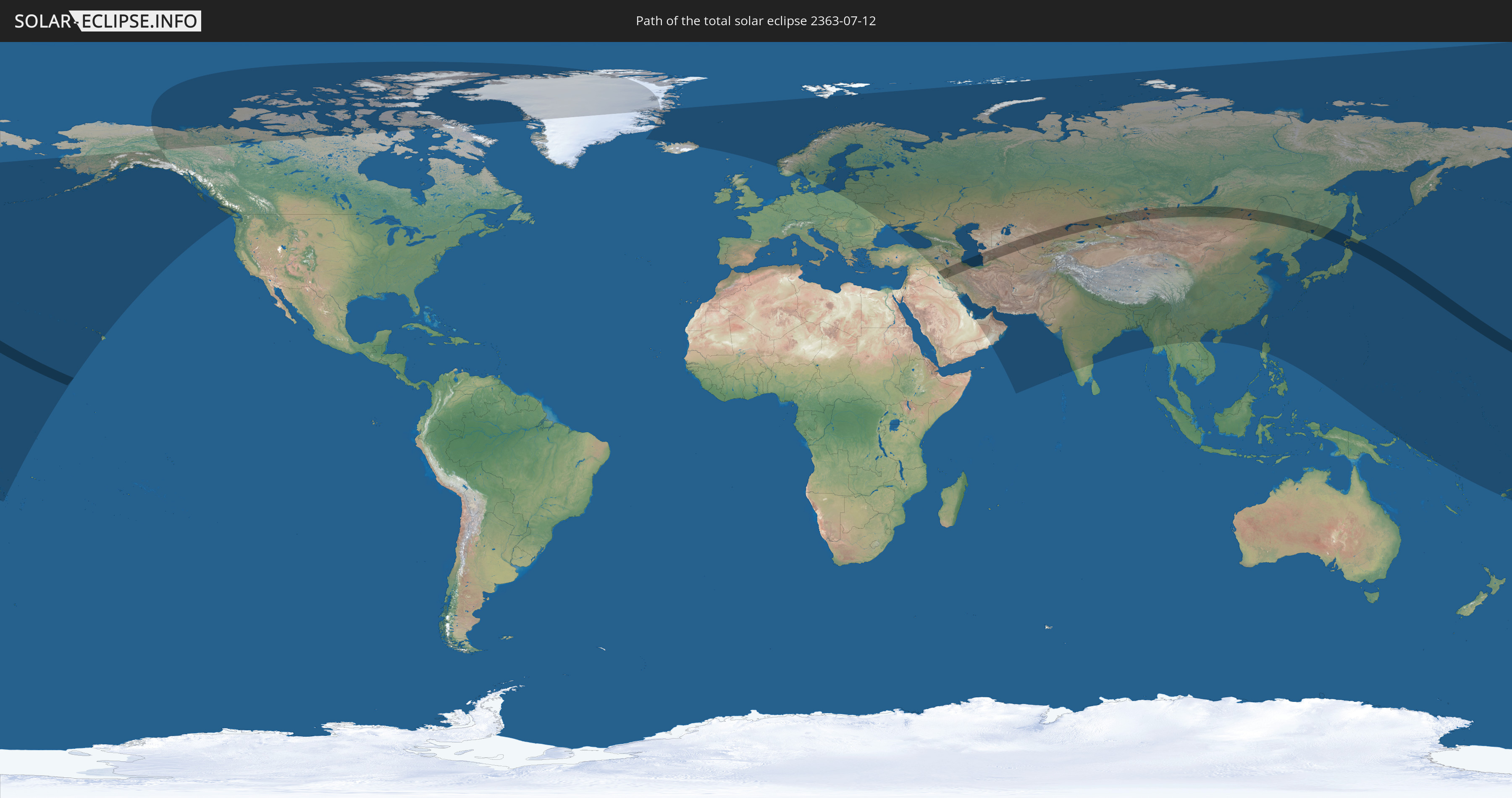
Die Sonnenfinsternis am 07/12/2363 kann man in 66 Ländern als partielle Sonnenfinsternis beobachten.
Der Finsternispfad verläuft durch 9 Länder. Nur in diesen Ländern ist sie als total Sonnenfinsternis zu sehen.
In den folgenden Ländern ist die Sonnenfinsternis total zu sehen
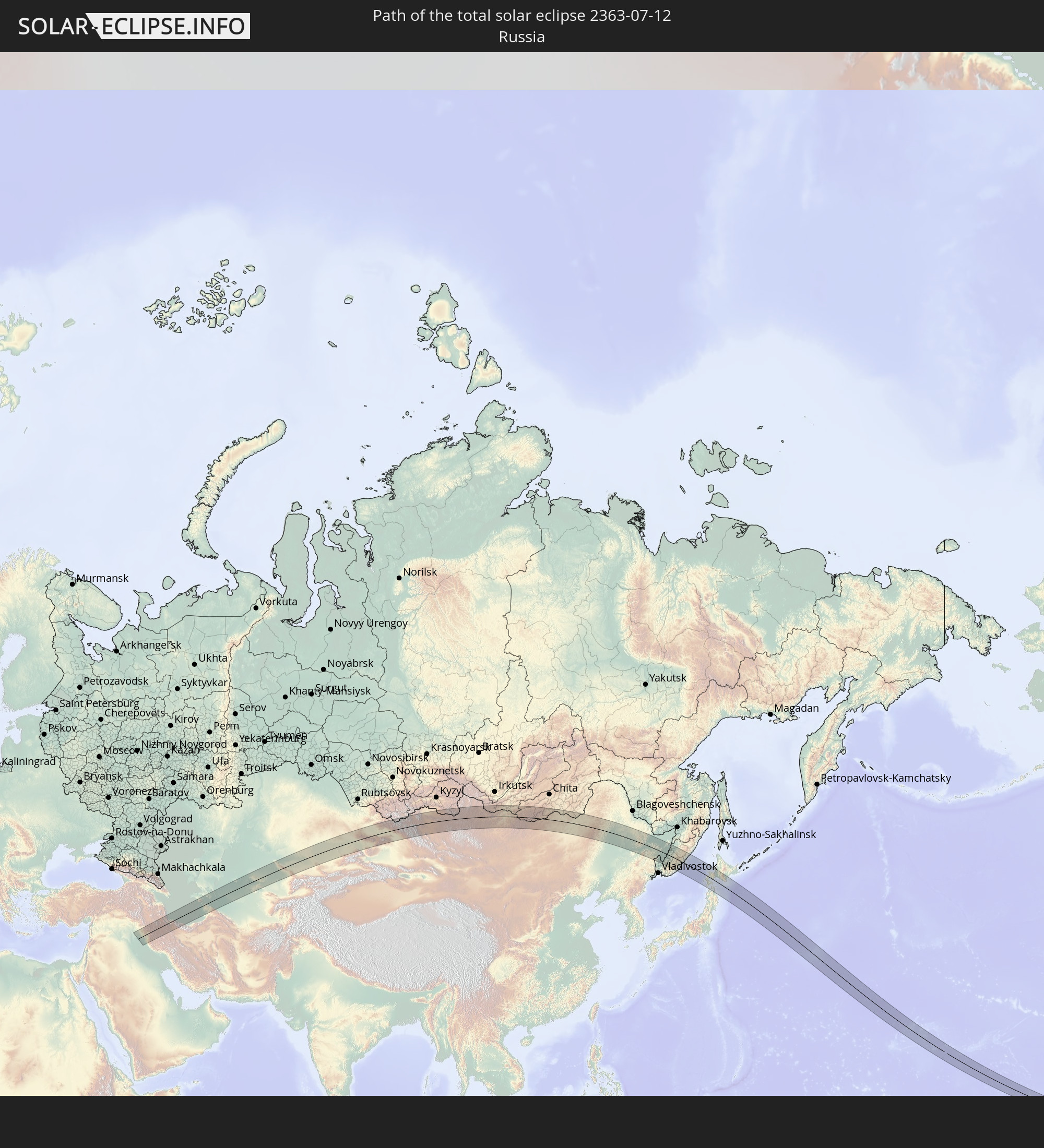 Russia
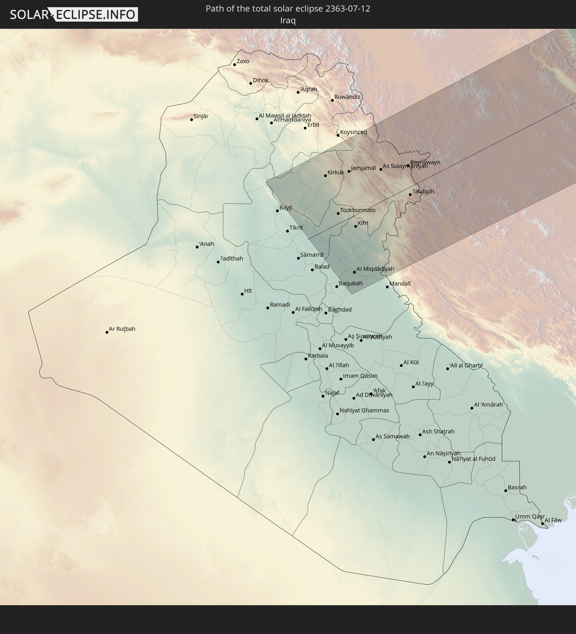 Iraq
Iraq
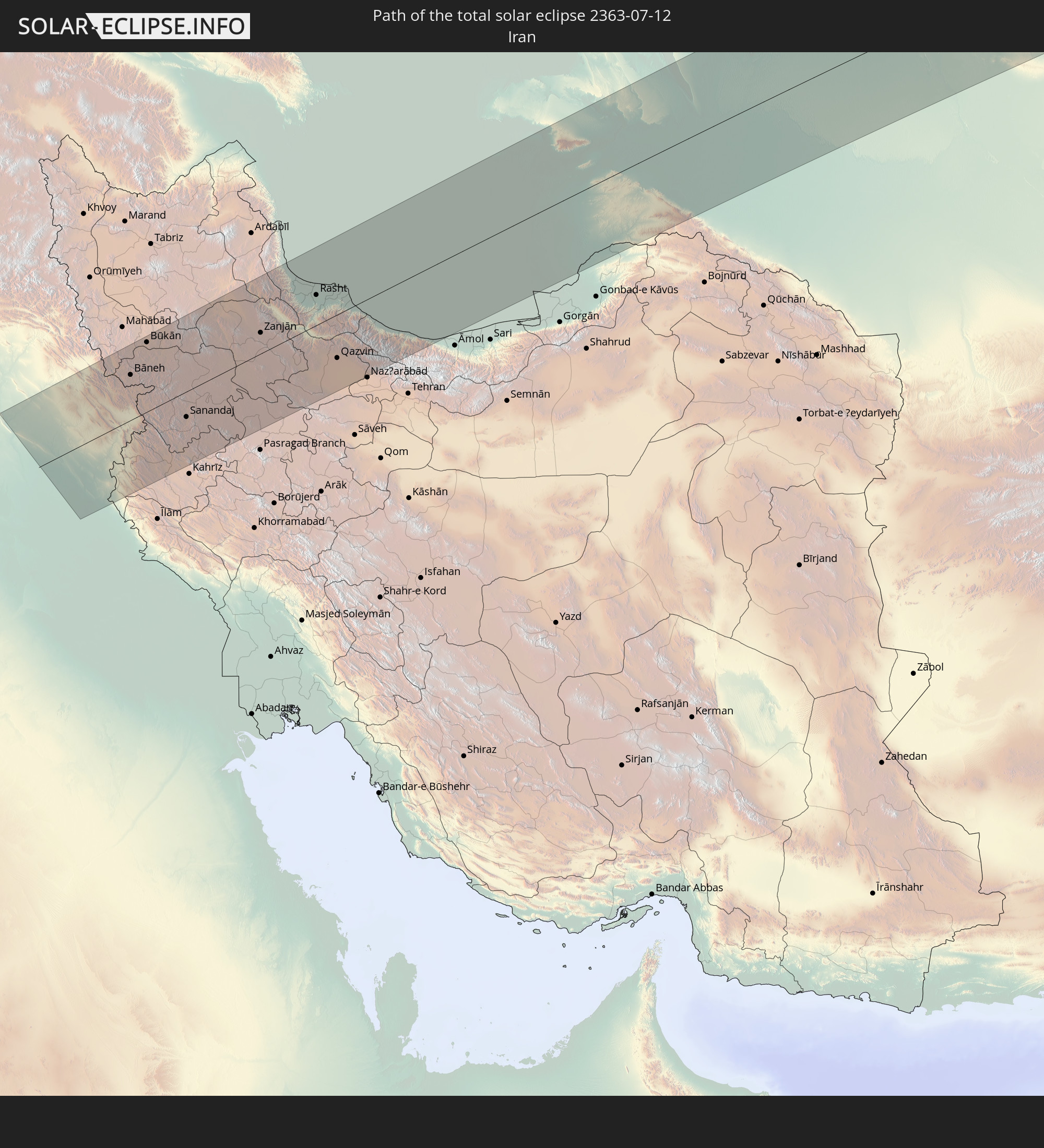 Iran
Iran
 Kazakhstan
 Turkmenistan
 Uzbekistan
 China
China
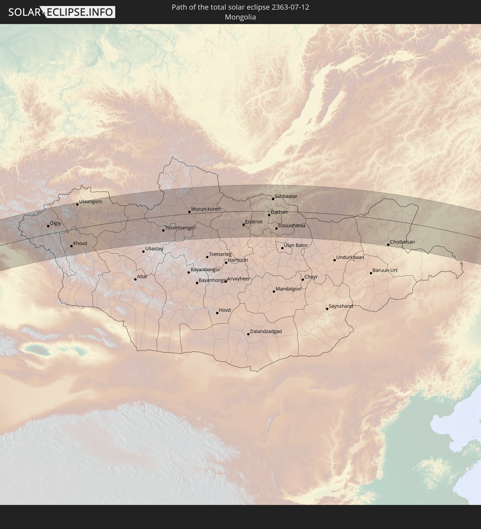 Mongolia
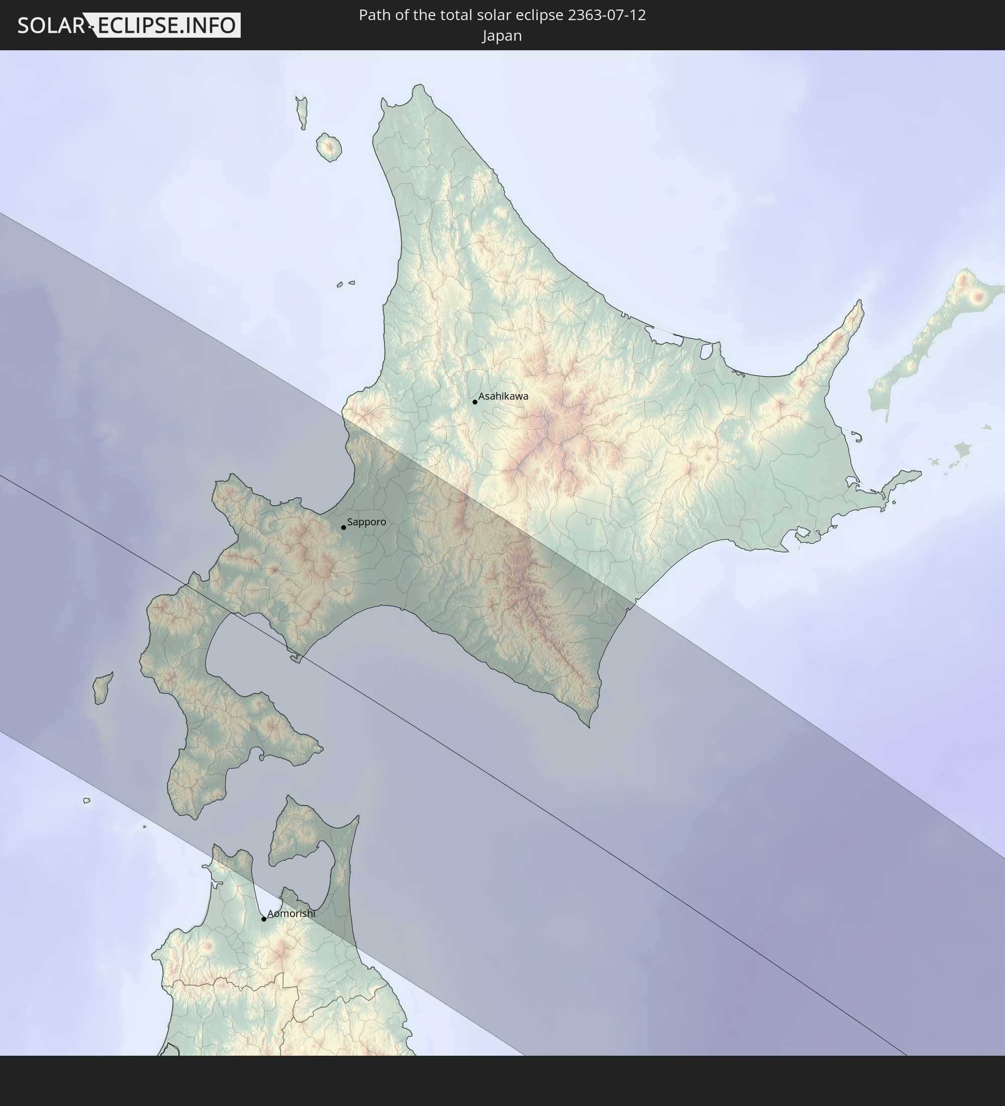 Japan
Japan
In den folgenden Ländern ist die Sonnenfinsternis partiell zu sehen
 Fiji
Fiji
 Russia
 United States
 United States Minor Outlying Islands
 Wallis and Futuna
 Kiribati
 Canada
 Greenland
 Iceland
 Svalbard and Jan Mayen
 Norway
 Sweden
 Poland
 Åland Islands
 Finland
 Lithuania
 Latvia
 Estonia
 Ukraine
 Belarus
 Turkey
 Moldova
 Saudi Arabia
 Syria
Syria
 Iraq
Iraq
 Georgia
 Armenia
 Iran
Iran
 Azerbaijan
 Kazakhstan
 Kuwait
 Bahrain
 Qatar
Qatar
 United Arab Emirates
 Oman
Oman
 Turkmenistan
 Uzbekistan
 Afghanistan
 Pakistan
 Tajikistan
 India
India
 Kyrgyzstan
 China
China
 Nepal
Nepal
 Mongolia
 Bangladesh
 Bhutan
 Myanmar
 Thailand
 Laos
Laos
 Vietnam
 Macau
Macau
 Hong Kong
 Taiwan
 Philippines
 Japan
Japan
 North Korea
 South Korea
 Federated States of Micronesia
 Papua New Guinea
 Guam
Guam
 Northern Mariana Islands
 Solomon Islands
 Marshall Islands
 Nauru
Nauru
 Tuvalu
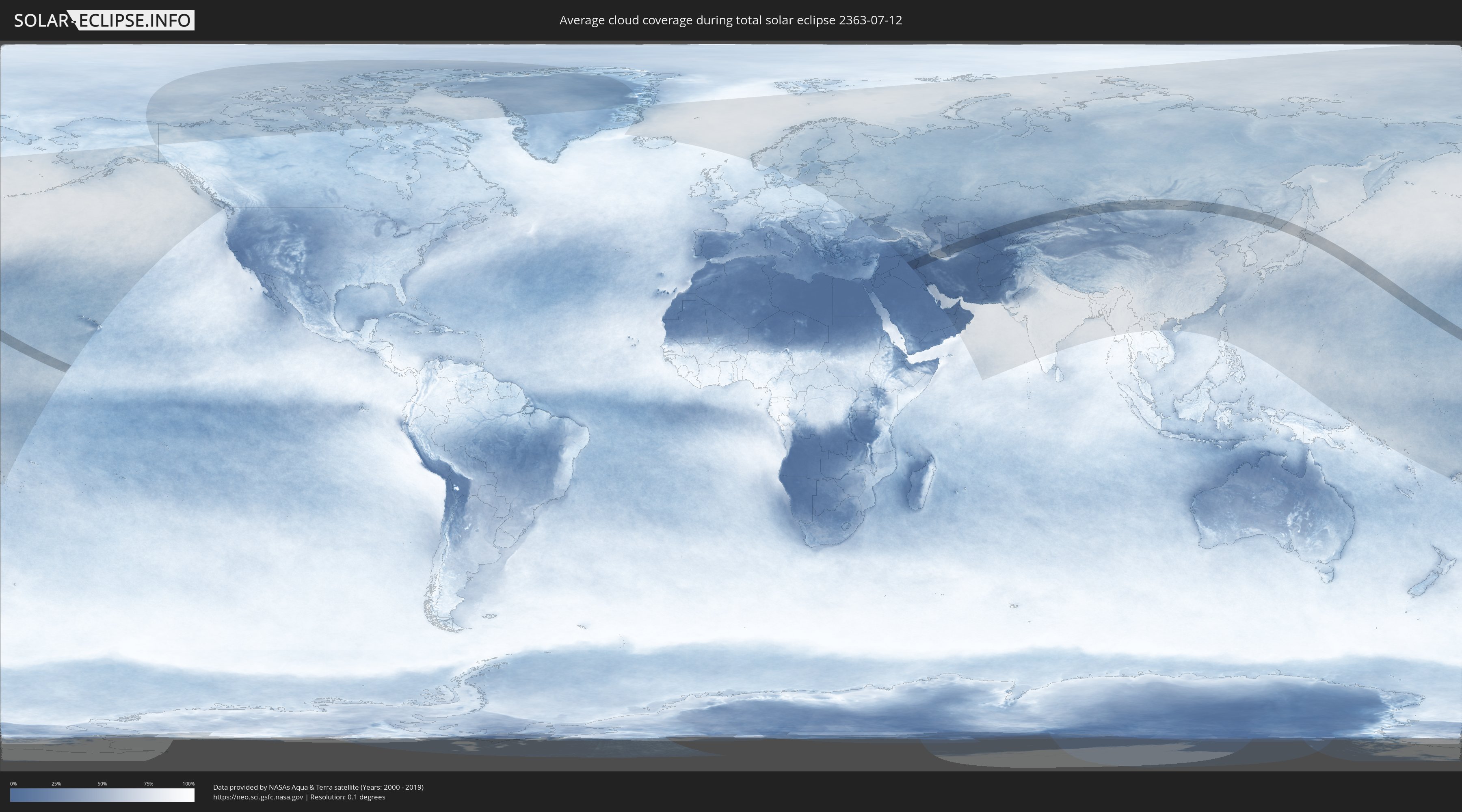
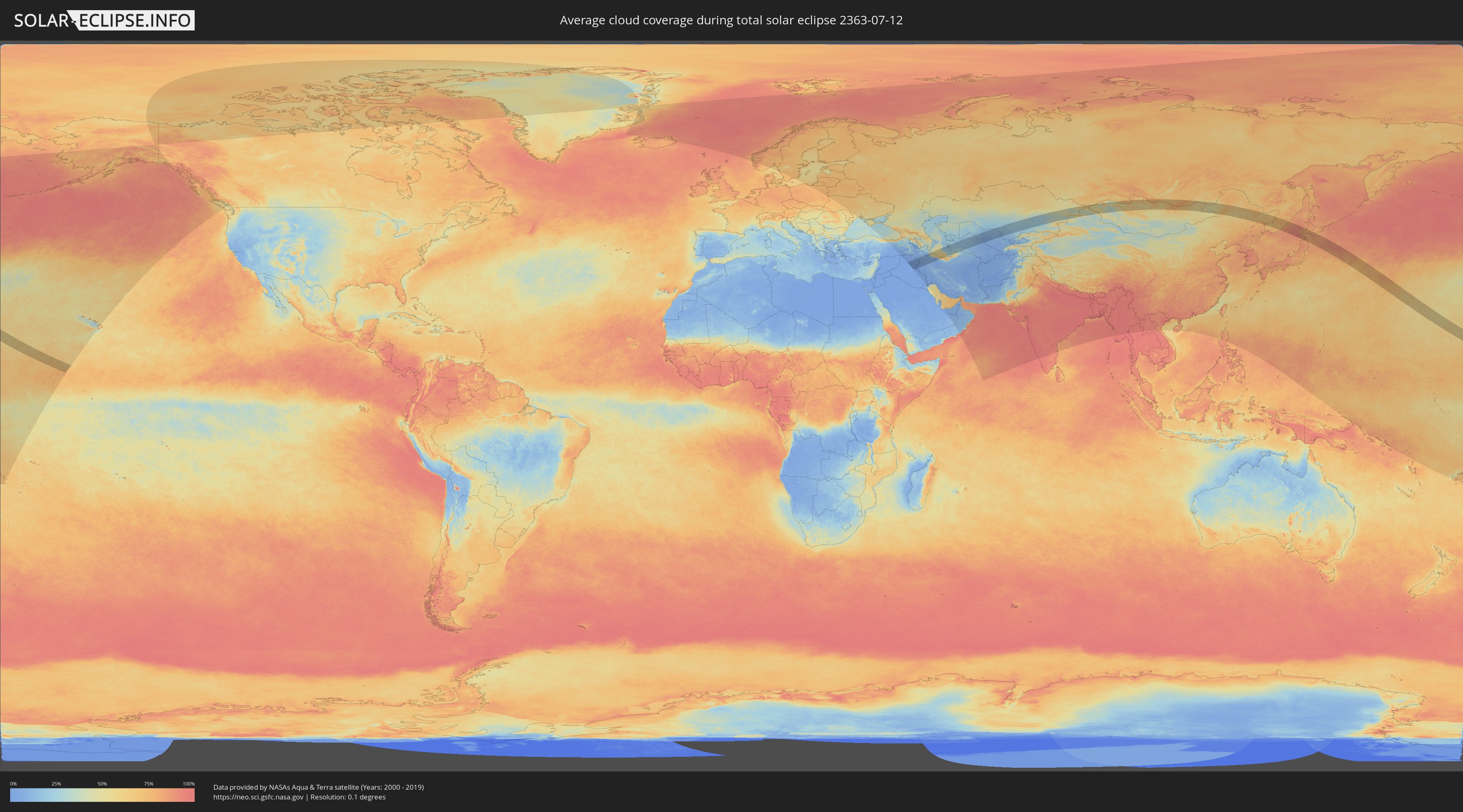
How will be the weather during the total solar eclipse on 07/12/2363?
Where is the best place to see the total solar eclipse of 07/12/2363?
The following maps show the average cloud coverage for the day of the total solar eclipse.
With the help of these maps, it is possible to find the place along the eclipse path, which has the best
chance of a cloudless sky.
Nevertheless, you should consider local circumstances and inform about the weather of your chosen
observation site.
The data is provided by NASAs satellites
AQUA and TERRA.
The cloud maps are averaged over a period of 19 years (2000 - 2019).
Detailed country maps
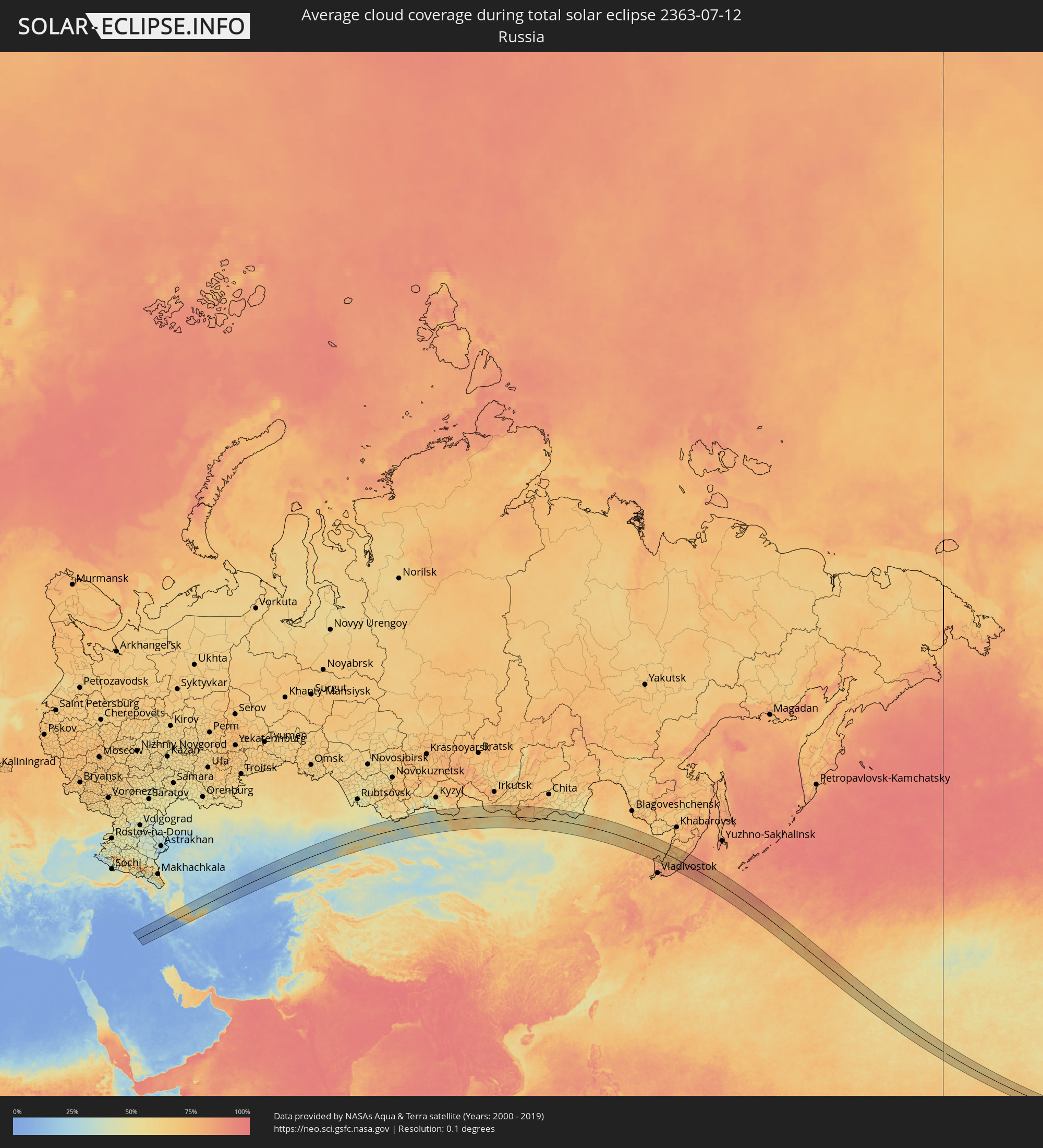 Russia
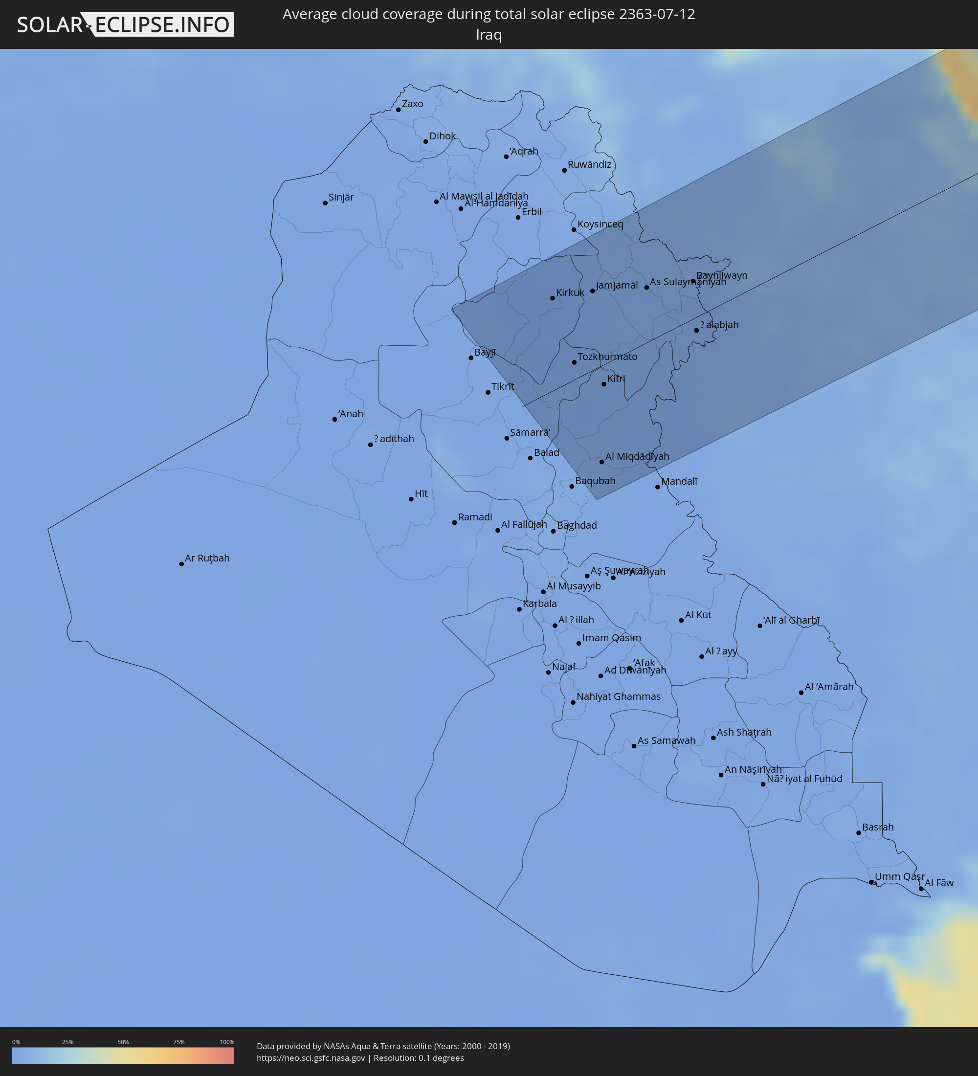 Iraq
Iraq
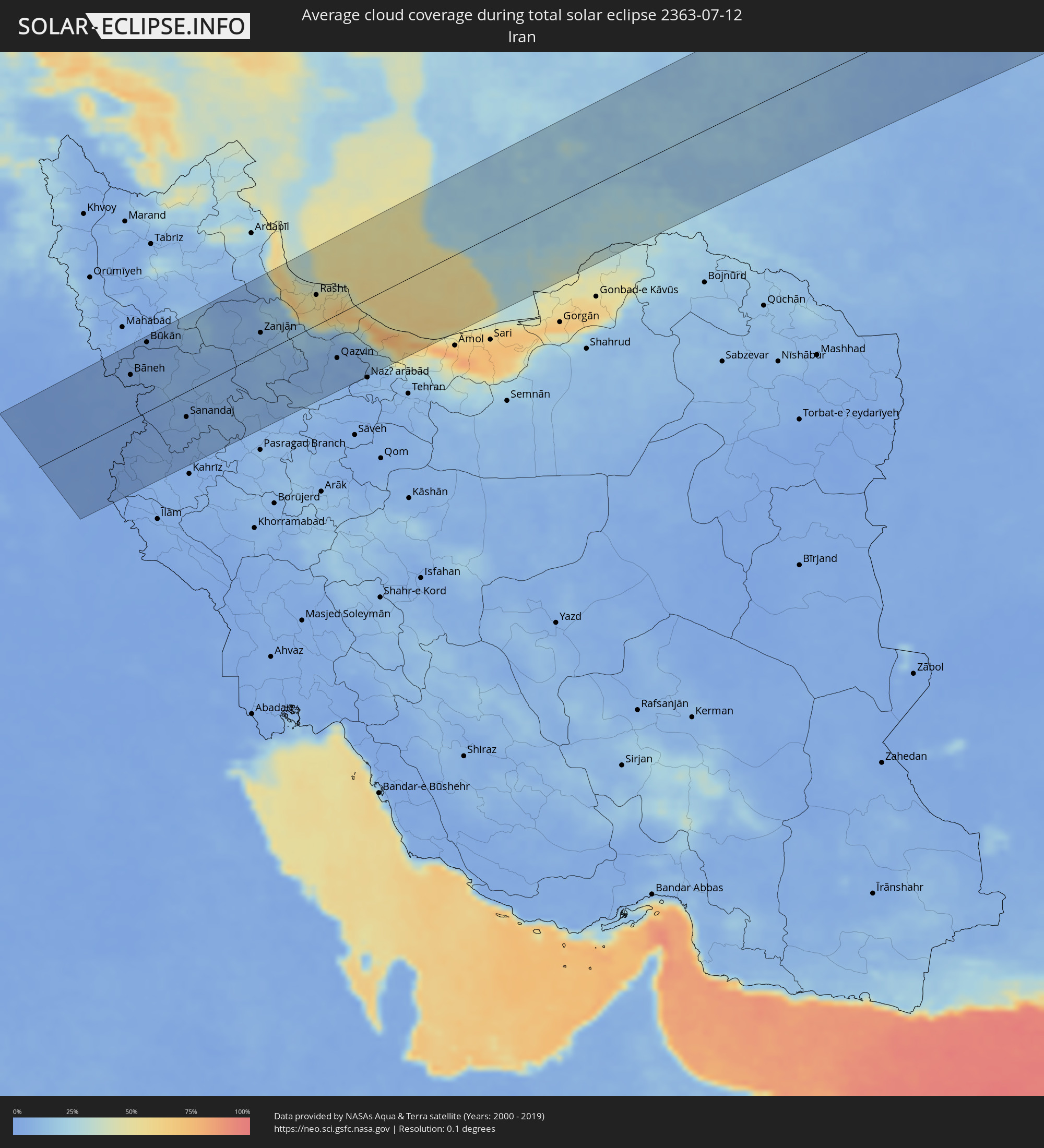 Iran
Iran
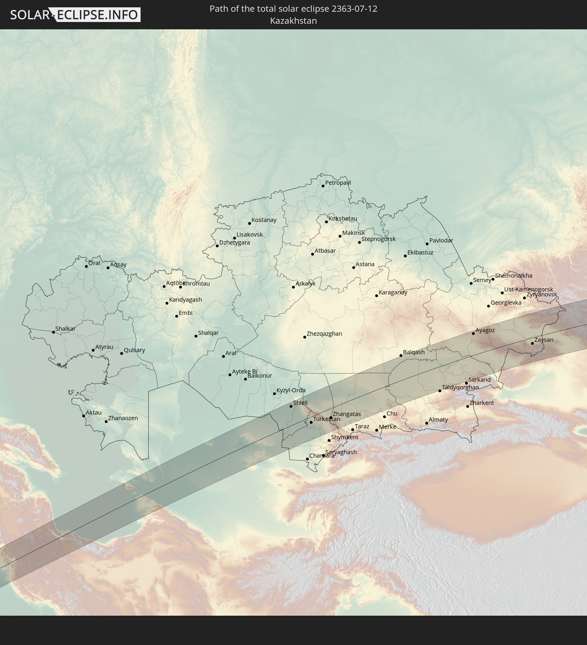
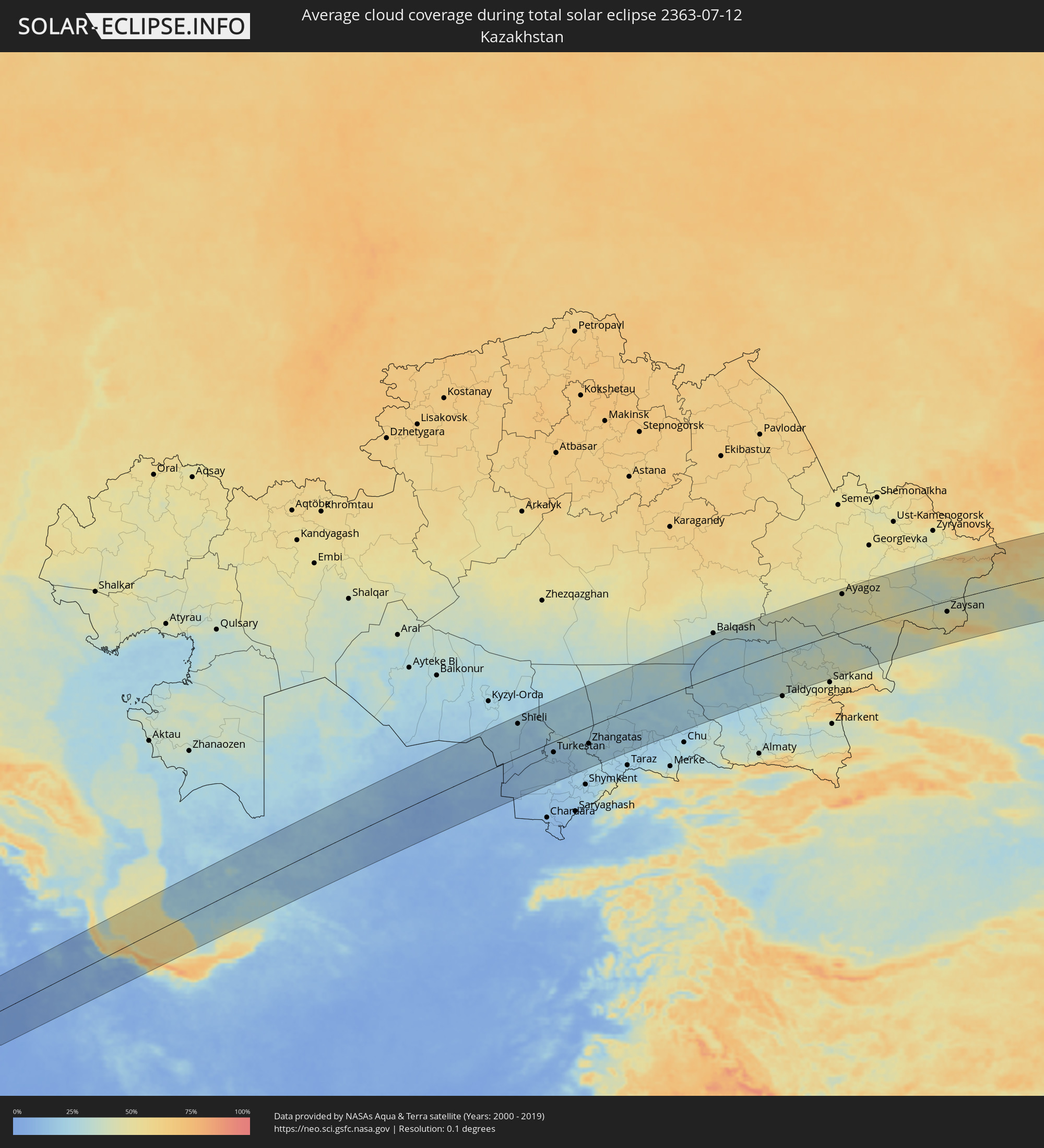 Kazakhstan
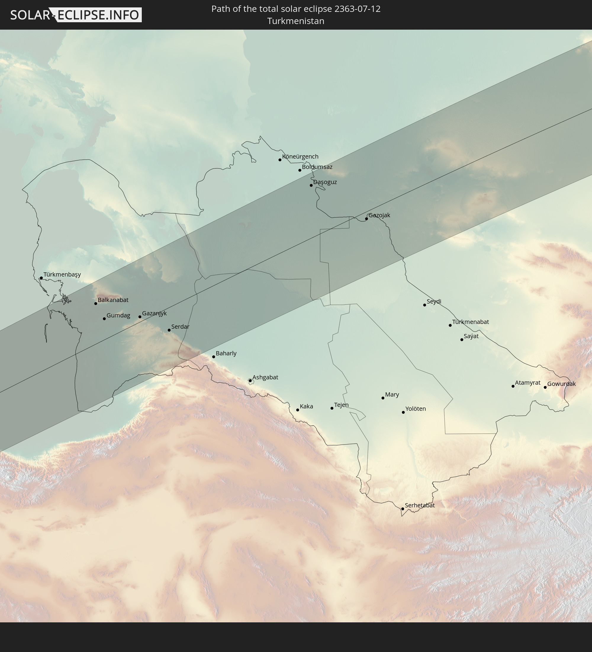
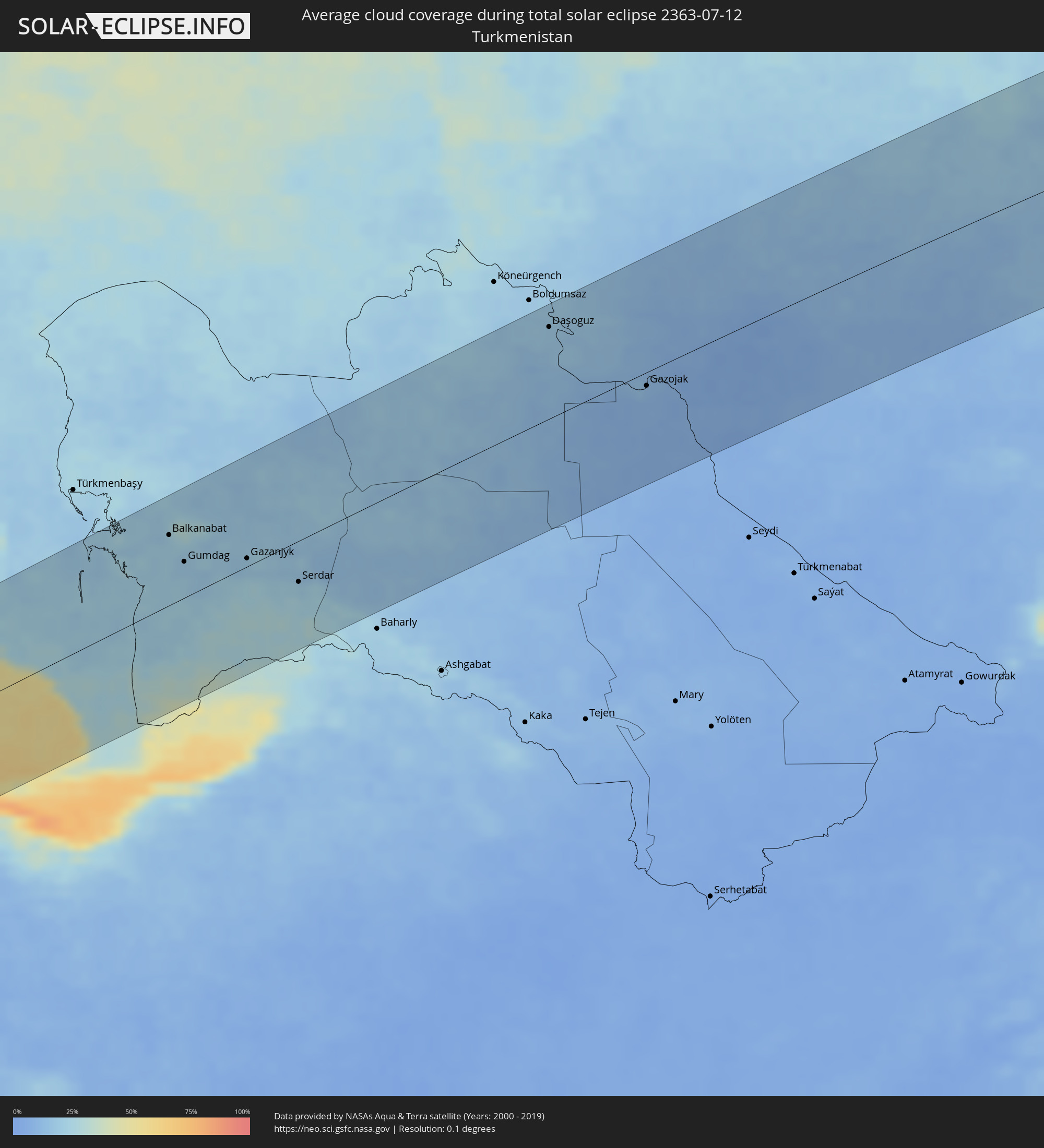 Turkmenistan
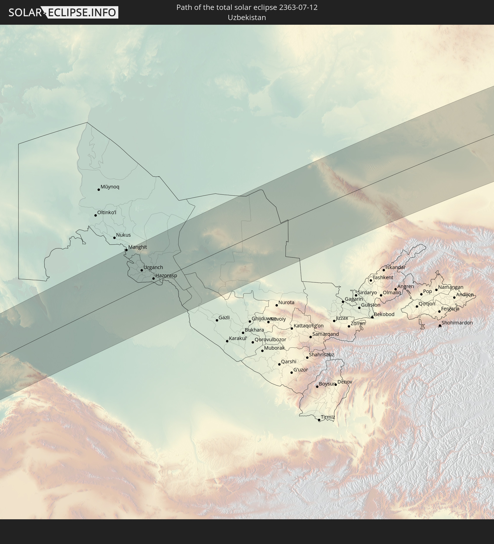
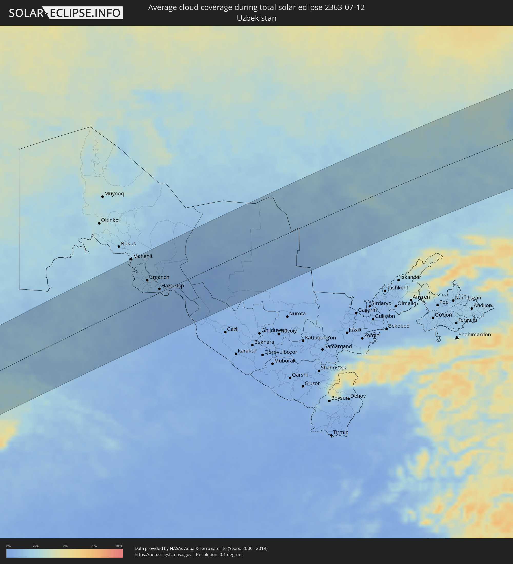 Uzbekistan
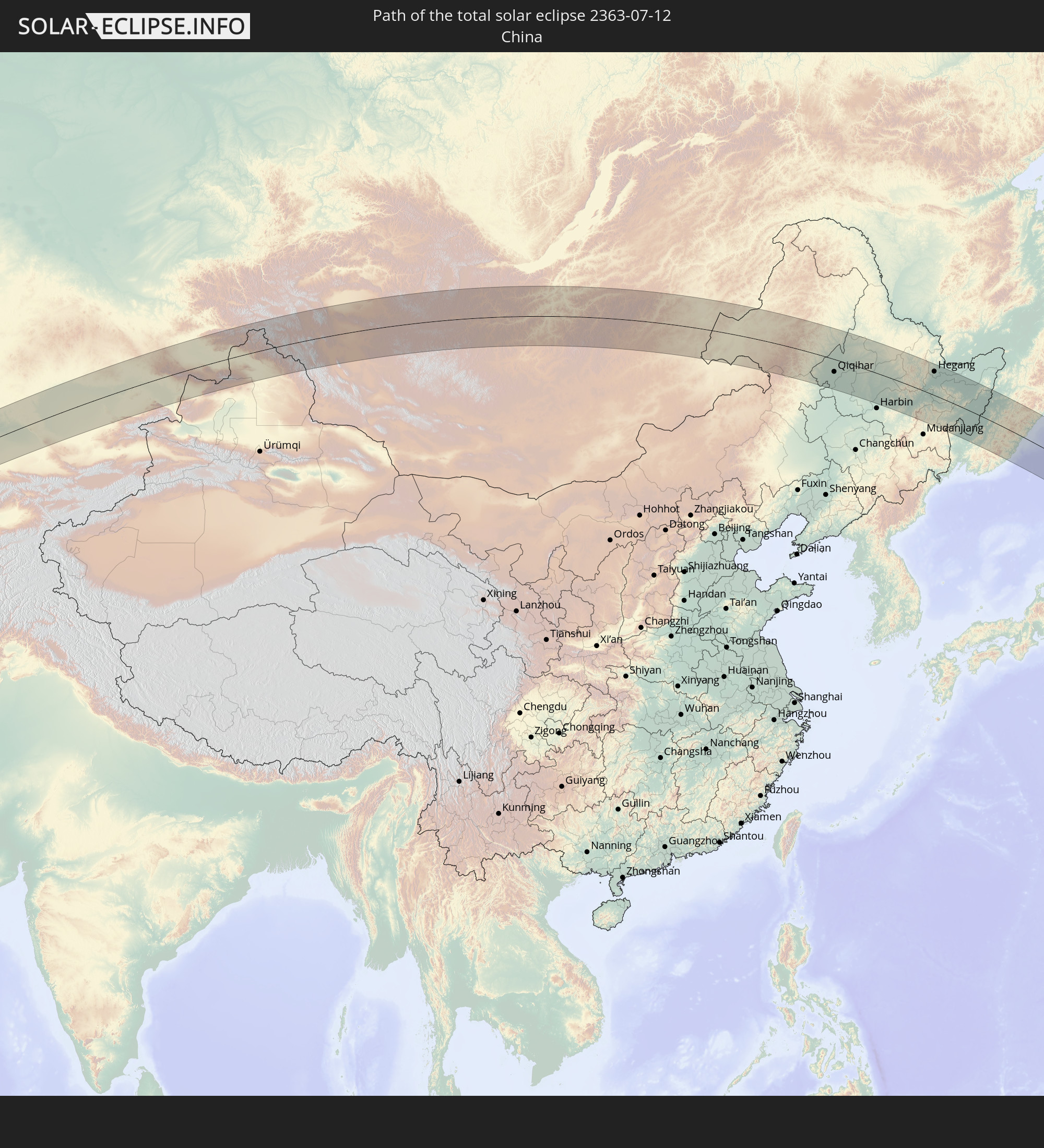
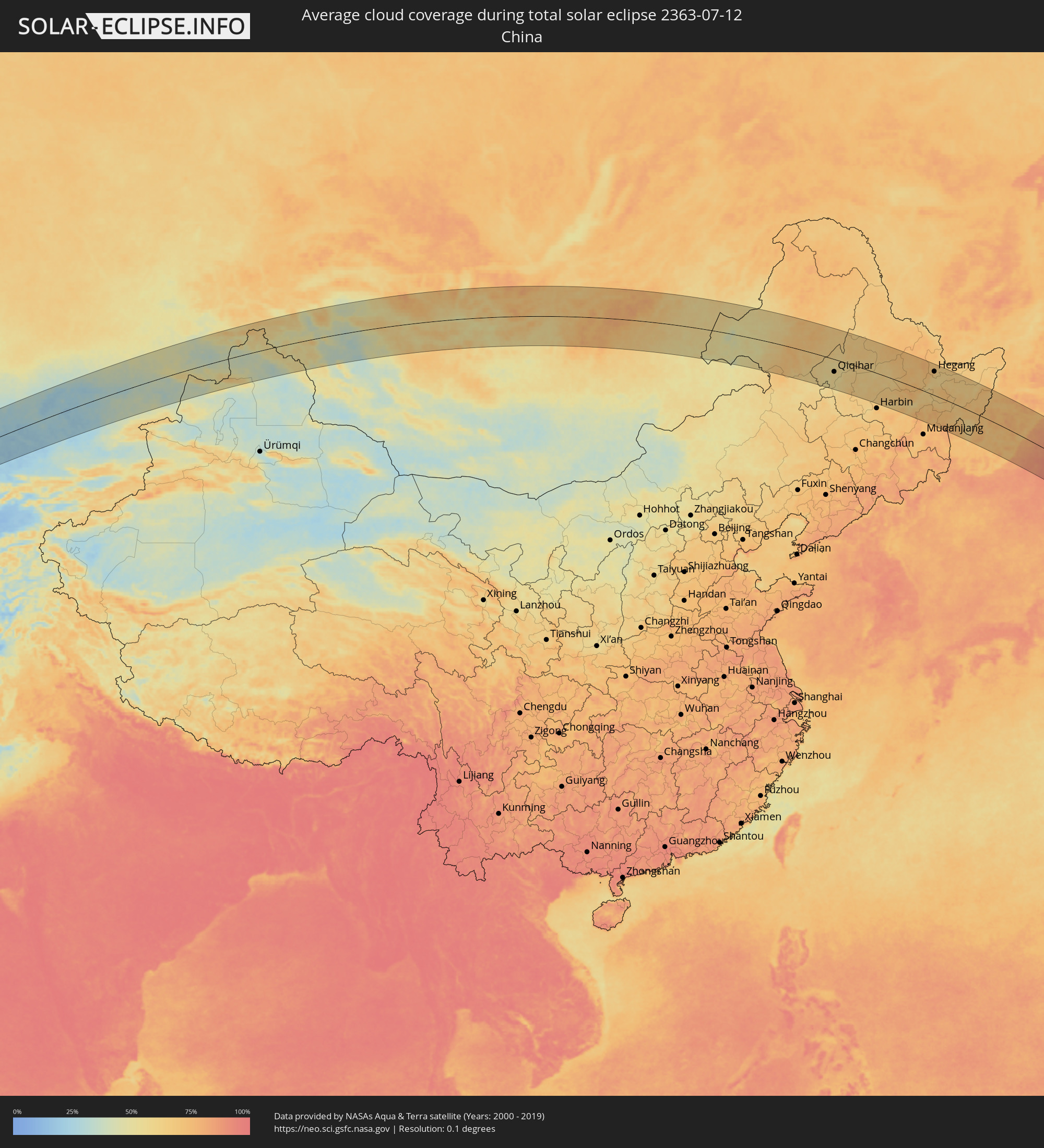 China
China
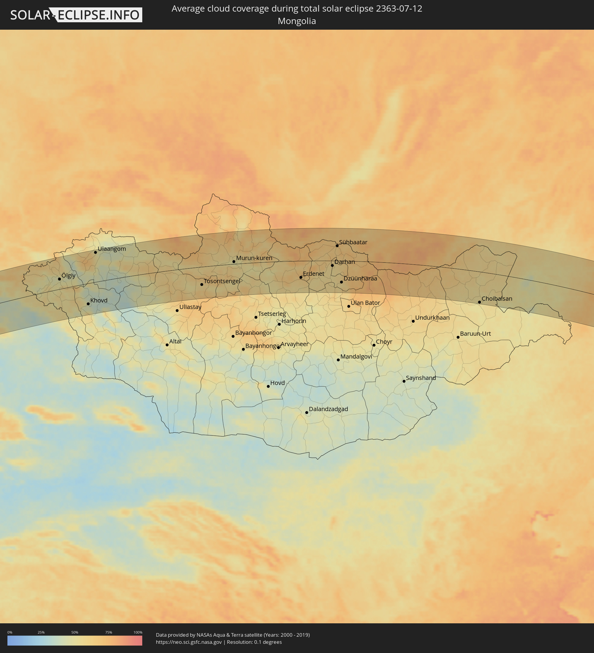 Mongolia
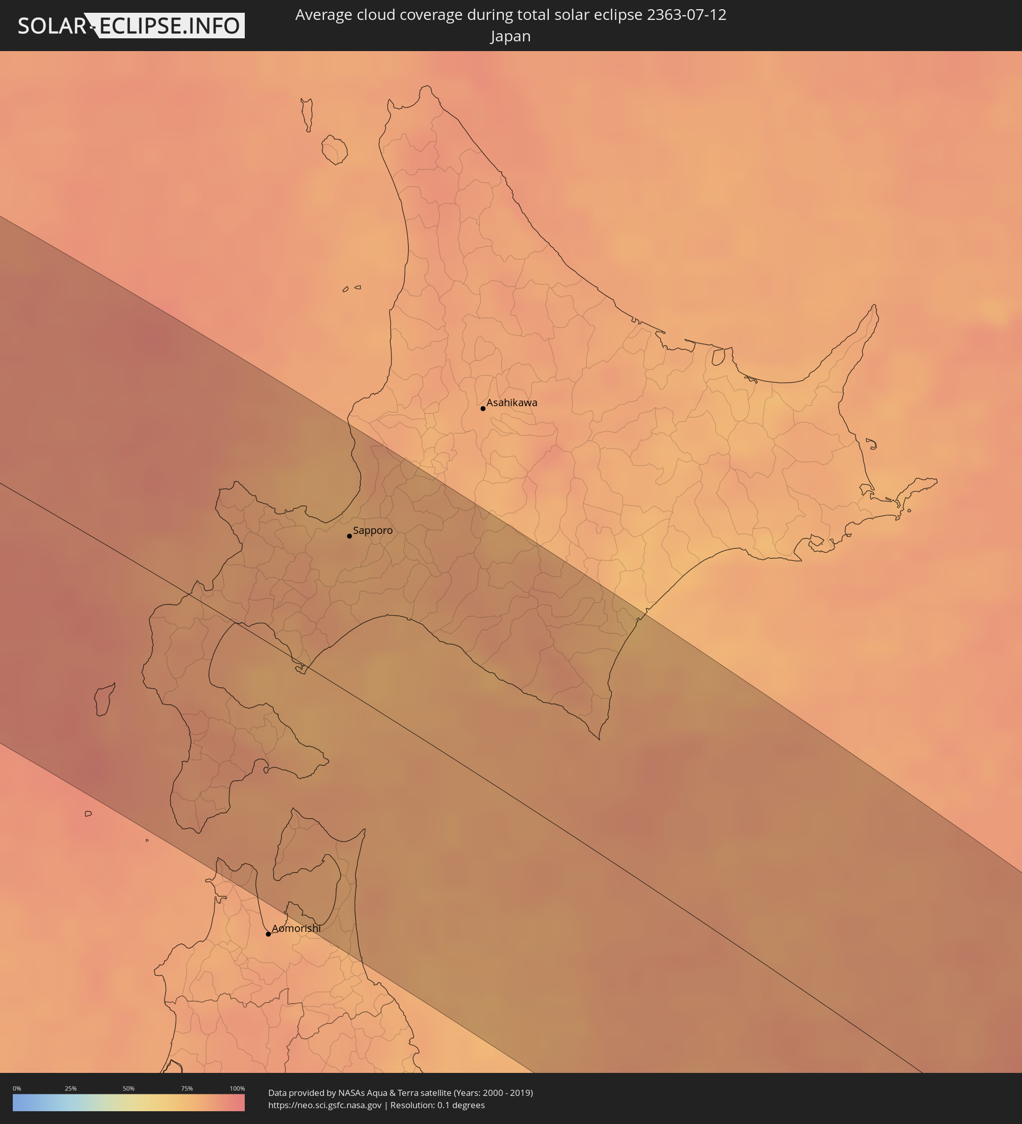 Japan
Japan
Cities inside the path of the eclipse
The following table shows all locations with a population of more than 5,000 inside the eclipse path. Cities which have more than 100,000 inhabitants are marked bold. A click at the locations opens a detailed map.
| City | Type | Eclipse duration | Local time of max. eclipse | Distance to central line | Ø Cloud coverage |
|
Kirkuk, At Taʼmīm
|
total | - | 05:06:22 UTC+03:00 | 82 km | 1% |
|
Tozkhurmato, Salah ad Din Governorate
|
total | - | 05:05:49 UTC+03:00 | 15 km | 1% |
|
Jamjamāl, As Sulaymānīyah
|
total | - | 05:06:17 UTC+03:00 | 70 km | 1% |
|
Al Miqdādīyah, Diyālá
|
total | - | 05:05:01 UTC+03:00 | 88 km | 2% |
|
Kifrī, Diyālá
|
total | - | 05:05:34 UTC+03:00 | 18 km | 1% |
|
As Sulaymānīyah, As Sulaymānīyah
|
total | - | 05:06:08 UTC+03:00 | 49 km | 2% |
|
Sarpol-e Z̄ahāb, Kermānshāh
|
total | - | 05:35:07 UTC+03:30 | 79 km | 2% |
|
Bāneh, Kordestān
|
total | - | 05:36:21 UTC+03:30 | 73 km | 4% |
|
Baynjiwayn, As Sulaymānīyah
|
total | - | 05:06:02 UTC+03:00 | 33 km | 2% |
|
Ḩalabjah, As Sulaymānīyah
|
total | - | 05:05:39 UTC+03:00 | 13 km | 2% |
|
Būkān, Āz̄ārbāyjān-e Gharbī
|
total | - | 05:36:42 UTC+03:30 | 111 km | 4% |
|
Saqqez, Kordestān
|
total | - | 05:36:28 UTC+03:30 | 82 km | 4% |
|
Kāmyārān, Kordestān
|
total | - | 05:35:04 UTC+03:30 | 90 km | 3% |
|
Sanandaj, Kordestān
|
total | - | 05:35:29 UTC+03:30 | 41 km | 4% |
|
Takāb, Āz̄ārbāyjān-e Gharbī
|
total | - | 05:36:22 UTC+03:30 | 62 km | 9% |
|
Sonqor, Kermānshāh
|
total | - | 05:34:53 UTC+03:30 | 118 km | 5% |
|
Bījār, Kordestān
|
total | - | 05:35:47 UTC+03:30 | 11 km | 7% |
|
Qorveh, Kordestān
|
total | - | 05:35:09 UTC+03:30 | 89 km | 8% |
|
Zanjān, Zanjan
|
total | - | 05:36:17 UTC+03:30 | 33 km | 9% |
|
Alvand, Zanjan
|
total | - | 05:35:49 UTC+03:30 | 30 km | 8% |
|
Khorramdarreh, Zanjan
|
total | - | 05:35:43 UTC+03:30 | 42 km | 9% |
|
Abhar, Zanjan
|
total | - | 05:35:40 UTC+03:30 | 49 km | 6% |
|
Bandar-e Anzalī, Gīlān
|
total | - | 05:36:47 UTC+03:30 | 72 km | 39% |
|
Rasht, Gīlān
|
total | - | 05:36:35 UTC+03:30 | 48 km | 55% |
|
Tākestān, Qazvīn
|
total | - | 05:35:30 UTC+03:30 | 76 km | 7% |
|
Āstāneh-ye Ashrafīyeh, Gīlān
|
total | - | 05:36:30 UTC+03:30 | 32 km | 55% |
|
Qazvin, Qazvīn
|
total | - | 05:35:36 UTC+03:30 | 69 km | 8% |
|
Langarūd, Gīlān
|
total | - | 05:36:24 UTC+03:30 | 17 km | 55% |
|
Rūdsar, Gīlān
|
total | - | 05:36:19 UTC+03:30 | 6 km | 61% |
|
Ābyek, Markazi
|
total | - | 05:35:20 UTC+03:30 | 111 km | 7% |
|
Chālūs, Māzandarān
|
total | - | 05:35:42 UTC+03:30 | 88 km | 64% |
|
Balkanabat, Balkan
|
total | - | 07:08:03 UTC+05:00 | 80 km | 22% |
|
Gumdag, Balkan
|
total | - | 07:07:44 UTC+05:00 | 41 km | 18% |
|
Gazanjyk, Balkan
|
total | - | 07:07:43 UTC+05:00 | 9 km | 19% |
|
Serdar, Balkan
|
total | - | 07:07:26 UTC+05:00 | 47 km | 20% |
|
Yylanly, Daşoguz
|
total | - | 07:10:26 UTC+05:00 | 113 km | 18% |
|
Tagta, Daşoguz
|
total | - | 07:10:16 UTC+05:00 | 85 km | 16% |
|
Daşoguz, Daşoguz
|
total | - | 07:10:28 UTC+05:00 | 102 km | 17% |
|
Manghit, Karakalpakstan
|
total | - | 07:10:46 UTC+05:00 | 127 km | 19% |
|
Showot, Xorazm
|
total | - | 07:10:18 UTC+05:00 | 72 km | 17% |
|
Qŭshkŭpir, Xorazm
|
total | - | 07:10:10 UTC+05:00 | 58 km | 15% |
|
Khiwa, Xorazm
|
total | - | 07:10:01 UTC+05:00 | 42 km | 14% |
|
Gurlan, Xorazm
|
total | - | 07:10:31 UTC+05:00 | 87 km | 15% |
|
Urganch, Xorazm
|
total | - | 07:10:13 UTC+05:00 | 49 km | 15% |
|
Beruniy, Karakalpakstan
|
total | - | 07:10:23 UTC+05:00 | 59 km | 15% |
|
Novyy Turtkul’, Karakalpakstan
|
total | - | 07:10:15 UTC+05:00 | 35 km | 13% |
|
Hazorasp, Xorazm
|
total | - | 07:10:01 UTC+05:00 | 10 km | 12% |
|
Gazojak, Lebap
|
total | - | 07:09:55 UTC+05:00 | 15 km | 10% |
|
Shīeli, Qyzylorda
|
total | - | 07:14:14 UTC+05:00 | 104 km | 23% |
|
Yanykurgan, Qyzylorda
|
total | - | 07:14:05 UTC+05:00 | 61 km | 18% |
|
Turkestan, Ongtüstik Qazaqstan
|
total | - | 07:13:41 UTC+05:00 | 34 km | 17% |
|
Kentau, Ongtüstik Qazaqstan
|
total | - | 07:14:01 UTC+05:00 | 19 km | 17% |
|
Kantagi, Ongtüstik Qazaqstan
|
total | - | 07:14:03 UTC+05:00 | 21 km | 18% |
|
Ashchysay, Ongtüstik Qazaqstan
|
total | - | 07:14:11 UTC+05:00 | 28 km | 25% |
|
Chulakkurgan, Ongtüstik Qazaqstan
|
total | - | 07:14:31 UTC+05:00 | 15 km | 21% |
|
Chayan, Ongtüstik Qazaqstan
|
total | - | 07:13:46 UTC+05:00 | 96 km | 20% |
|
Zhangatas, Zhambyl
|
total | - | 07:14:29 UTC+05:00 | 53 km | 20% |
|
Karatau, Zhambyl
|
total | - | 07:14:20 UTC+05:00 | 115 km | 23% |
|
Moyynkum, Zhambyl
|
total | - | 07:16:36 UTC+05:00 | 75 km | 25% |
|
Priozersk
|
total | - | 07:18:58 UTC+05:00 | 84 km | 27% |
|
Bakanas, Almaty Oblysy
|
total | - | 07:18:53 UTC+05:00 | 114 km | 26% |
|
Ush-Tyube, Almaty Oblysy
|
total | - | 07:20:23 UTC+05:00 | 112 km | 36% |
|
Lepsy, Almaty Oblysy
|
total | - | 07:22:05 UTC+05:00 | 32 km | 37% |
|
Ayagoz, East Kazakhstan
|
total | - | 07:25:01 UTC+05:00 | 115 km | 45% |
|
Urzhar, East Kazakhstan
|
total | - | 07:24:51 UTC+05:00 | 4 km | 37% |
|
Kurchum, East Kazakhstan
|
total | - | 07:27:58 UTC+05:00 | 109 km | 40% |
|
Aksuat
|
total | - | 07:28:10 UTC+05:00 | 125 km | 43% |
|
Tūghyl, East Kazakhstan
|
total | - | 07:27:28 UTC+05:00 | 8 km | 42% |
|
Zaysan, East Kazakhstan
|
total | - | 07:27:43 UTC+05:00 | 33 km | 45% |
|
Altay, Xinjiang Uyghur Autonomous Region
|
total | - | 10:30:54 UTC+08:00 | 51 km | 38% |
|
Ölgiy, Bayan-Ölgiy
|
total | - | 09:33:43 UTC+07:00 | 41 km | 47% |
|
Khovd, Hovd
|
total | - | 09:34:25 UTC+07:00 | 88 km | 42% |
|
Ulaangom, Uvs
|
total | - | 09:36:43 UTC+07:00 | 122 km | 52% |
|
Tosontsengel, Dzabkhan
|
total | - | 09:42:23 UTC+07:00 | 76 km | 56% |
|
Murun-kuren, Hövsgöl
|
total | - | 10:45:17 UTC+08:00 | 9 km | 50% |
|
Zakamensk, Respublika Buryatiya
|
total | - | 10:49:37 UTC+08:00 | 80 km | 68% |
|
Bulgan, Bulgan
|
total | - | 10:49:03 UTC+08:00 | 95 km | 59% |
|
Erdenet, Orhon
|
total | - | 10:49:54 UTC+08:00 | 71 km | 61% |
|
Petropavlovka, Respublika Buryatiya
|
total | - | 10:52:21 UTC+08:00 | 104 km | 68% |
|
Darhan, Darhan Uul
|
total | - | 10:52:36 UTC+08:00 | 21 km | 56% |
|
Sühbaatar, Selenge
|
total | - | 10:53:20 UTC+08:00 | 62 km | 64% |
|
Kyakhta, Respublika Buryatiya
|
total | - | 10:53:42 UTC+08:00 | 76 km | 69% |
|
Dzüünharaa, Selenge
|
total | - | 10:53:03 UTC+08:00 | 91 km | 57% |
|
Bichura, Respublika Buryatiya
|
total | - | 10:55:21 UTC+08:00 | 104 km | 65% |
|
Krasnyy Chikoy, Transbaikal Territory
|
total | - | 11:56:49 UTC+09:00 | 82 km | 67% |
|
Choibalsan, East Aimak
|
total | - | 11:04:54 UTC+08:00 | 131 km | 52% |
|
Zabaykal’sk, Transbaikal Territory
|
total | - | 12:09:10 UTC+09:00 | 76 km | 55% |
|
Krasnokamensk, Transbaikal Territory
|
total | - | 12:10:12 UTC+09:00 | 135 km | 55% |
|
Hailar, Inner Mongolia
|
total | - | 11:12:53 UTC+08:00 | 62 km | 54% |
|
Yakeshi, Inner Mongolia
|
total | - | 11:14:28 UTC+08:00 | 88 km | 57% |
|
Zhalantun, Inner Mongolia
|
total | - | 11:18:05 UTC+08:00 | 11 km | 65% |
|
Hulan Ergi, Heilongjiang
|
total | - | 11:19:55 UTC+08:00 | 79 km | 55% |
|
Qiqihar, Heilongjiang
|
total | - | 11:20:23 UTC+08:00 | 57 km | 58% |
|
Fendou, Heilongjiang
|
total | - | 11:22:16 UTC+08:00 | 111 km | 68% |
|
Honggang, Heilongjiang
|
total | - | 11:22:26 UTC+08:00 | 136 km | 69% |
|
Longfeng, Heilongjiang
|
total | - | 11:22:44 UTC+08:00 | 117 km | 65% |
|
Anda, Heilongjiang
|
total | - | 11:23:10 UTC+08:00 | 126 km | 65% |
|
Bei’an, Heilongjiang
|
total | - | 11:24:10 UTC+08:00 | 102 km | 65% |
|
Hulan, Heilongjiang
|
total | - | 11:25:37 UTC+08:00 | 138 km | 69% |
|
Hailun, Heilongjiang
|
total | - | 11:25:14 UTC+08:00 | 26 km | 62% |
|
Suihua, Heilongjiang
|
total | - | 11:25:51 UTC+08:00 | 59 km | 67% |
|
Tieli, Heilongjiang
|
total | - | 11:27:21 UTC+08:00 | 4 km | 65% |
|
Yichun, Heilongjiang
|
total | - | 11:28:09 UTC+08:00 | 104 km | 69% |
|
Lianhe, Heilongjiang
|
total | - | 11:29:14 UTC+08:00 | 54 km | 69% |
|
Hegang, Heilongjiang
|
total | - | 11:30:43 UTC+08:00 | 106 km | 70% |
|
Jiamusi, Heilongjiang
|
total | - | 11:31:12 UTC+08:00 | 49 km | 65% |
|
Taihe, Heilongjiang
|
total | - | 11:32:58 UTC+08:00 | 41 km | 73% |
|
Jixi, Heilongjiang
|
total | - | 11:33:33 UTC+08:00 | 85 km | 73% |
|
Shuangyashan, Heilongjiang
|
total | - | 11:32:42 UTC+08:00 | 58 km | 69% |
|
Baoshan, Heilongjiang
|
total | - | 11:33:12 UTC+08:00 | 58 km | 67% |
|
Kamen’-Rybolov, Primorskiy
|
total | - | 13:35:55 UTC+10:00 | 107 km | 72% |
|
Khorol’, Primorskiy
|
total | - | 13:36:17 UTC+10:00 | 138 km | 72% |
|
Chernigovka, Primorskiy
|
total | - | 13:37:12 UTC+10:00 | 130 km | 72% |
|
Spasskoye, Primorskiy
|
total | - | 13:37:19 UTC+10:00 | 95 km | 72% |
|
Spassk-Dal’niy, Primorskiy
|
total | - | 13:37:23 UTC+10:00 | 96 km | 72% |
|
Arsen’yev, Primorskiy
|
total | - | 13:38:36 UTC+10:00 | 125 km | 69% |
|
Lesozavodsk, Primorskiy
|
total | - | 13:37:29 UTC+10:00 | 13 km | 71% |
|
Kirovskiy, Primorskiy
|
total | - | 13:38:00 UTC+10:00 | 23 km | 68% |
|
Gornyye Klyuchi, Primorskiy
|
total | - | 13:37:51 UTC+10:00 | 8 km | 69% |
|
Dal’nerechensk, Primorskiy
|
total | - | 13:37:32 UTC+10:00 | 69 km | 72% |
|
Chuguyevka, Primorskiy
|
total | - | 13:39:35 UTC+10:00 | 103 km | 67% |
|
Luchegorsk, Primorskiy
|
total | - | 13:37:42 UTC+10:00 | 139 km | 71% |
|
Kavalerovo, Primorskiy
|
total | - | 13:41:26 UTC+10:00 | 51 km | 69% |
|
Dal'negorsk, Primorskiy
|
total | - | 13:41:57 UTC+10:00 | 3 km | 69% |
|
Plastun, Primorskiy
|
total | - | 13:42:52 UTC+10:00 | 43 km | 76% |
|
Iwanai, Hokkaido
|
total | - | 12:51:47 UTC+09:00 | 38 km | 82% |
|
Kamiiso, Hokkaido
|
total | - | 12:53:35 UTC+09:00 | 66 km | 82% |
|
Nanae, Hokkaido
|
total | - | 12:53:33 UTC+09:00 | 58 km | 84% |
|
Hakodate, Hokkaido
|
total | - | 12:53:47 UTC+09:00 | 66 km | 82% |
|
Yoichi, Hokkaido
|
total | - | 12:51:53 UTC+09:00 | 71 km | 82% |
|
Date, Hokkaido
|
total | - | 12:53:02 UTC+09:00 | 5 km | 78% |
|
Muroran, Hokkaido
|
total | - | 12:53:26 UTC+09:00 | 4 km | 79% |
|
Otaru, Hokkaido
|
total | - | 12:52:15 UTC+09:00 | 79 km | 80% |
|
Mutsu, Aomori
|
total | - | 12:55:13 UTC+09:00 | 91 km | 79% |
|
Shiraoi, Hokkaido
|
total | - | 12:53:40 UTC+09:00 | 34 km | 81% |
|
Sapporo, Hokkaido
|
total | - | 12:52:57 UTC+09:00 | 83 km | 80% |
|
Ishikari, Hokkaido
|
total | - | 12:52:43 UTC+09:00 | 99 km | 79% |
|
Misawa, Aomori
|
total | - | 12:56:22 UTC+09:00 | 140 km | 80% |
|
Tōbetsu, Hokkaido
|
total | - | 12:53:00 UTC+09:00 | 104 km | 78% |
|
Ebetsu, Hokkaido
|
total | - | 12:53:12 UTC+09:00 | 95 km | 80% |
|
Kitahiroshima, Hokkaido
|
total | - | 12:53:24 UTC+09:00 | 83 km | 80% |
|
Tomakomai, Hokkaido
|
total | - | 12:53:56 UTC+09:00 | 53 km | 80% |
|
Chitose, Hokkaido
|
total | - | 12:53:45 UTC+09:00 | 72 km | 78% |
|
Iwamizawa, Hokkaido
|
total | - | 12:53:23 UTC+09:00 | 113 km | 79% |
|
Bibai, Hokkaido
|
total | - | 12:53:22 UTC+09:00 | 129 km | 81% |
|
Shizunai-furukawachō, Hokkaido
|
total | - | 12:55:31 UTC+09:00 | 58 km | 81% |