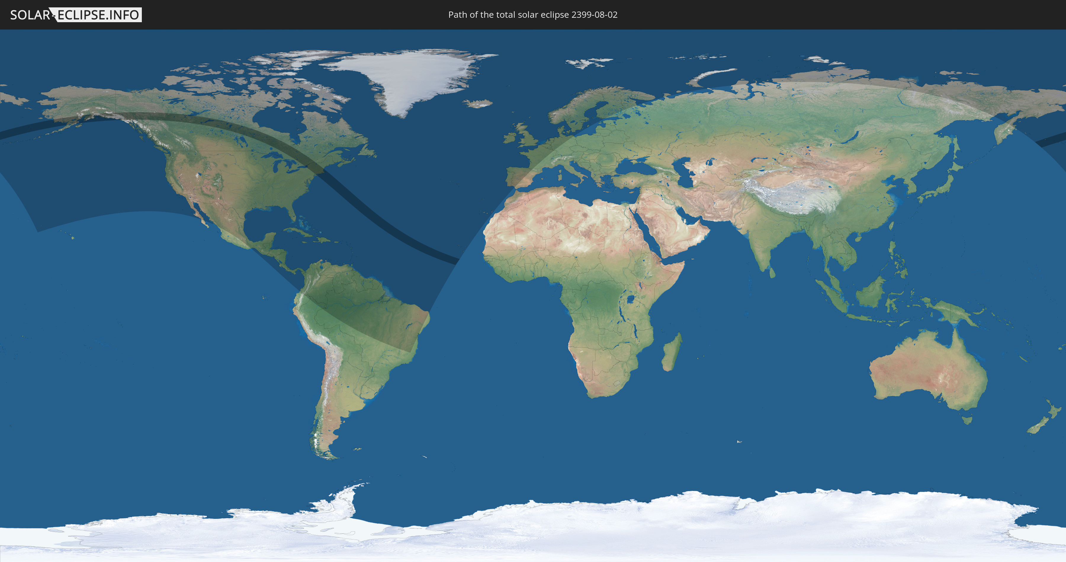
Total solar eclipse of 08/02/2399
| Day of week: | Monday |
| Maximum duration of eclipse: | 05m14s |
| Maximum width of eclipse path: | 291 km |
| Saros cycle: | 142 |
| Coverage: | 100% |
| Magnitude: | 1.0754 |
| Gamma: | 0.5482 |
Wo kann man die Sonnenfinsternis vom 08/02/2399 sehen?
Die Sonnenfinsternis am 08/02/2399 kann man in 70 Ländern als partielle Sonnenfinsternis beobachten.
Der Finsternispfad verläuft durch 2 Länder. Nur in diesen Ländern ist sie als total Sonnenfinsternis zu sehen.
In den folgenden Ländern ist die Sonnenfinsternis total zu sehen
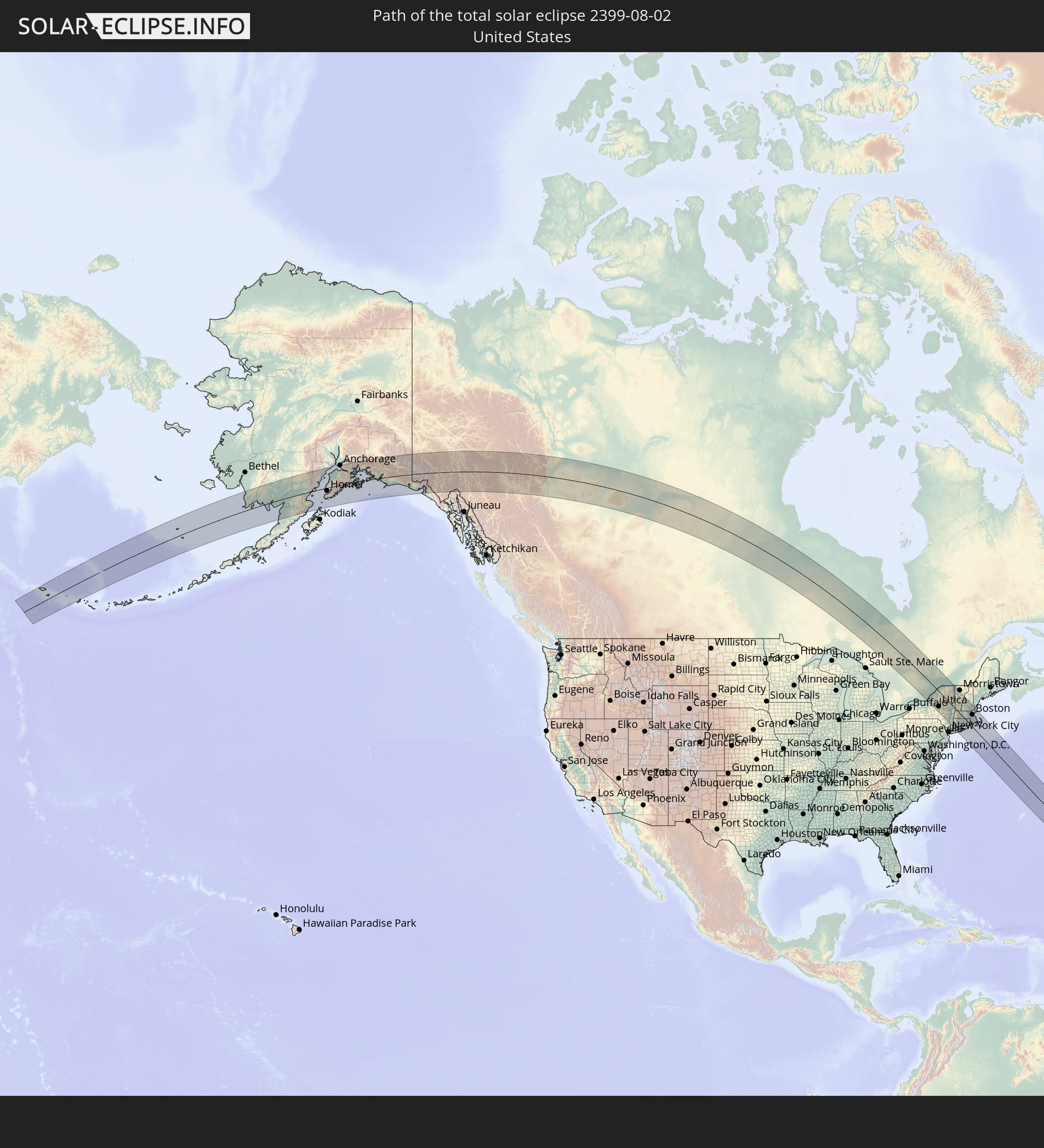 United States
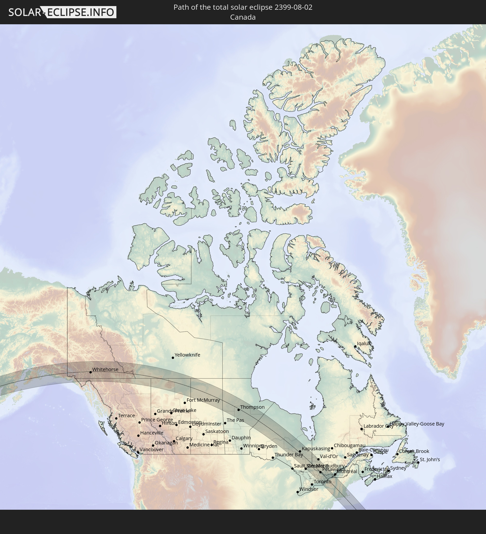 Canada
In den folgenden Ländern ist die Sonnenfinsternis partiell zu sehen
 Russia
 United States
 United States Minor Outlying Islands
 Canada
 Mexico
 Greenland
 Guatemala
 Ecuador
 El Salvador
 Honduras
 Belize
 Nicaragua
 Costa Rica
 Cuba
Cuba
 Panama
 Colombia
 Cayman Islands
 Peru
Peru
 The Bahamas
 Jamaica
 Haiti
Haiti
 Brazil
 Venezuela
 Turks and Caicos Islands
 Dominican Republic
 Aruba
Aruba
 Puerto Rico
 United States Virgin Islands
 Bermuda
 British Virgin Islands
 Anguilla
 Collectivity of Saint Martin
 Saint Barthélemy
 Saint Kitts and Nevis
 Antigua and Barbuda
 Montserrat
 Trinidad and Tobago
 Guadeloupe
 Grenada
 Dominica
 Saint Vincent and the Grenadines
 Guyana
 Martinique
 Saint Lucia
 Barbados
 Suriname
 Saint Pierre and Miquelon
 French Guiana
 Portugal
 Cabo Verde
 Iceland
 Spain
Spain
 Republic of Ireland
 Svalbard and Jan Mayen
 United Kingdom
 Faroe Islands
 France
 Isle of Man
 Guernsey
 Jersey
 Belgium
 Netherlands
 Norway
 Luxembourg
 Germany
 Denmark
 Sweden
 Åland Islands
 Finland
 Estonia
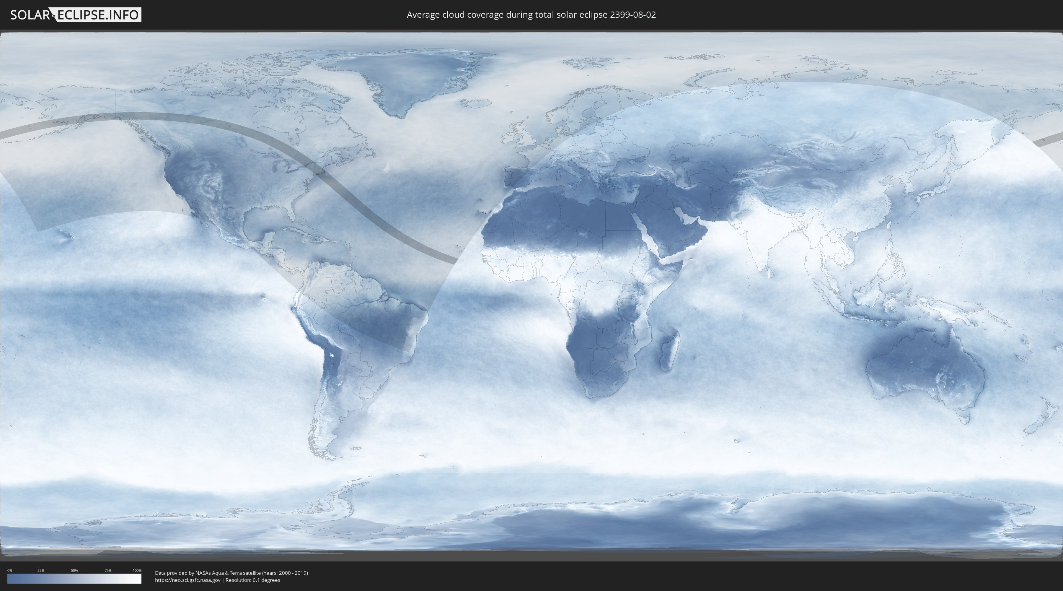
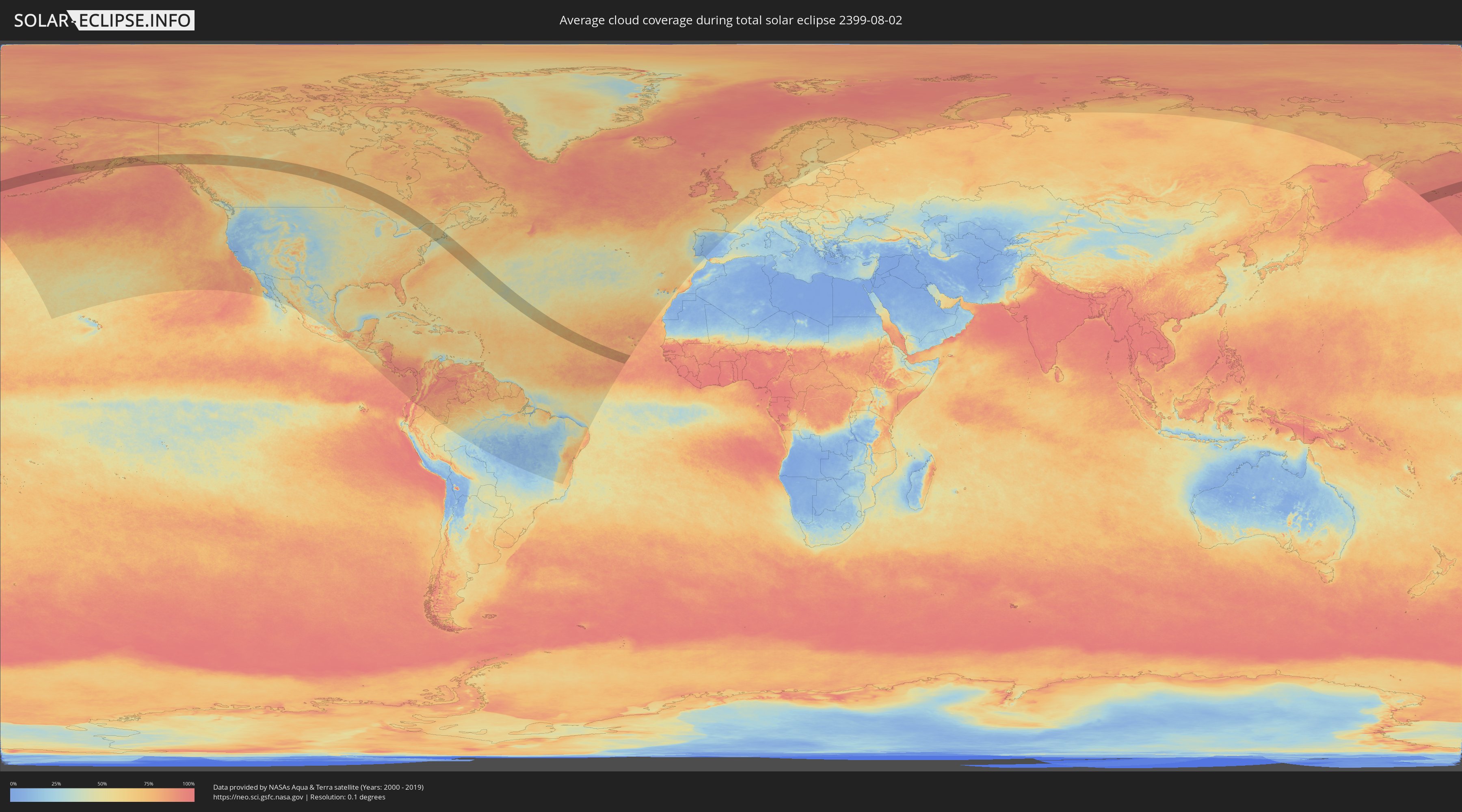
How will be the weather during the total solar eclipse on 08/02/2399?
Where is the best place to see the total solar eclipse of 08/02/2399?
The following maps show the average cloud coverage for the day of the total solar eclipse.
With the help of these maps, it is possible to find the place along the eclipse path, which has the best
chance of a cloudless sky.
Nevertheless, you should consider local circumstances and inform about the weather of your chosen
observation site.
The data is provided by NASAs satellites
AQUA and TERRA.
The cloud maps are averaged over a period of 19 years (2000 - 2019).
Detailed country maps
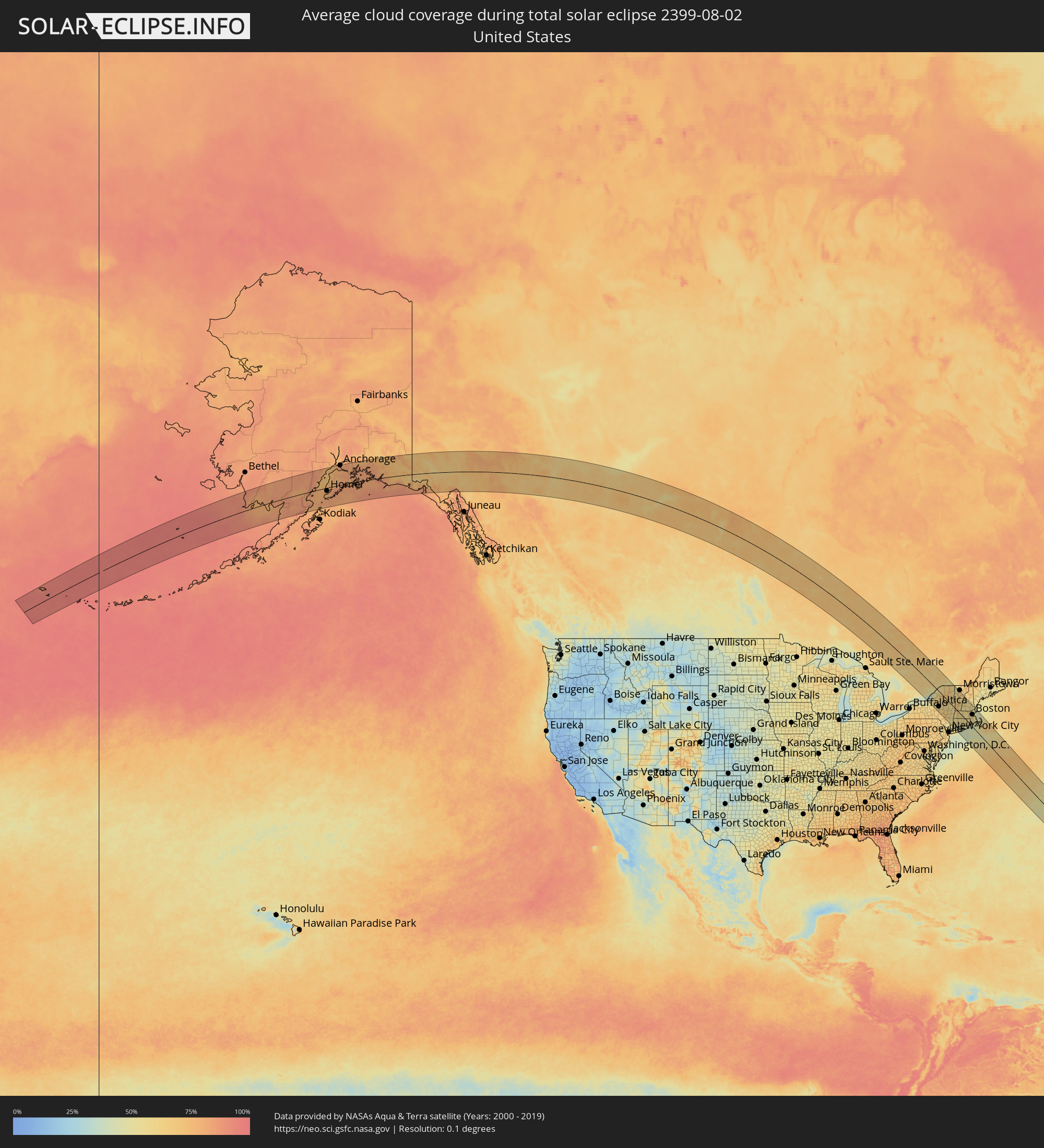 United States
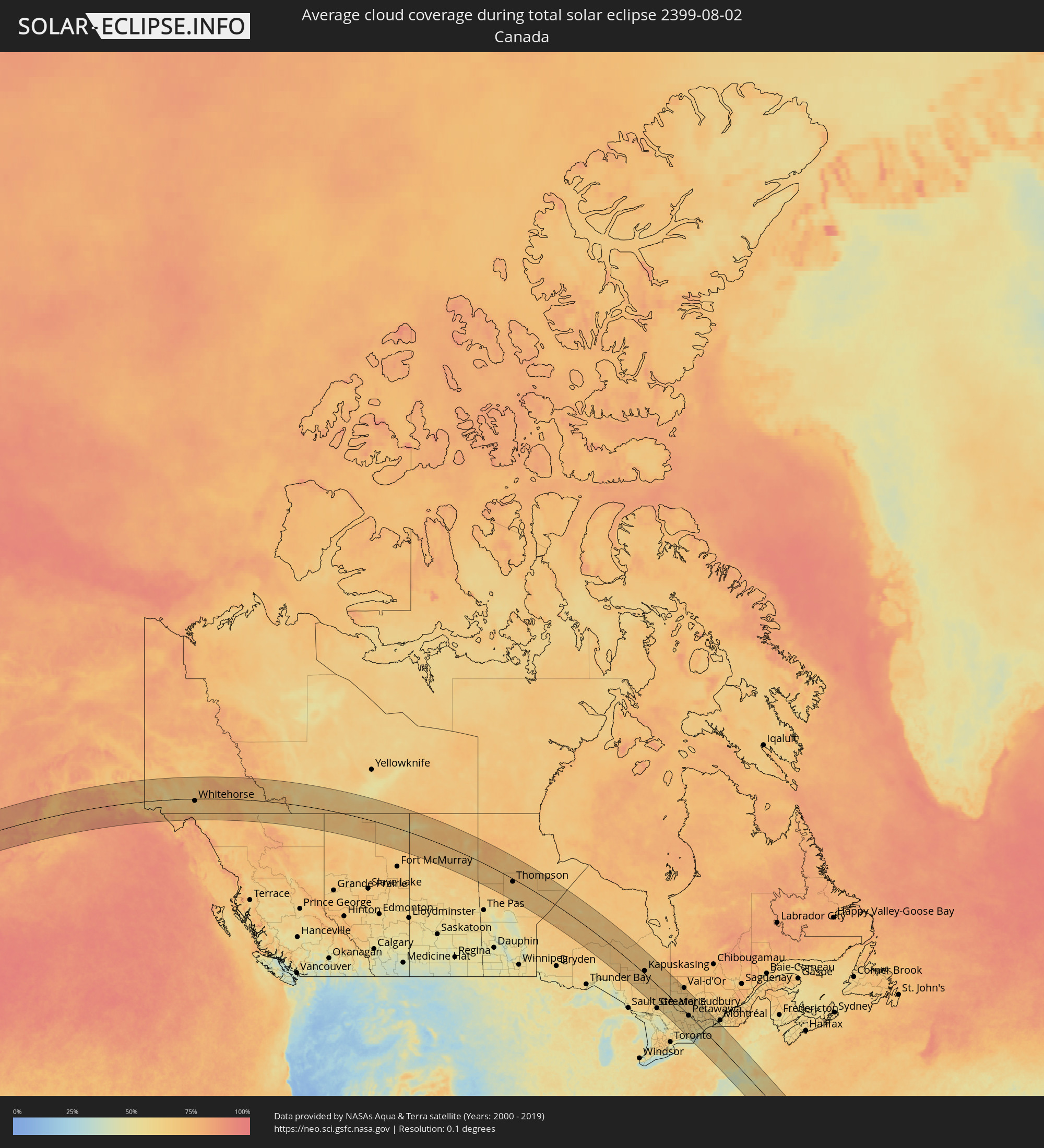 Canada
Cities inside the path of the eclipse
The following table shows all locations with a population of more than 5,000 inside the eclipse path. Cities which have more than 100,000 inhabitants are marked bold. A click at the locations opens a detailed map.
| City | Type | Eclipse duration | Local time of max. eclipse | Distance to central line | Ø Cloud coverage |
|
Anchorage, Alaska
|
total | - | 08:24:57 UTC-09:00 | 131 km | 78% |
|
Whitehorse, Yukon
|
total | - | 09:32:10 UTC-08:00 | 14 km | 67% |
|
Thompson, Manitoba
|
total | - | 12:07:27 UTC-06:00 | 18 km | 70% |
|
Kapuskasing, Ontario
|
total | - | 13:33:04 UTC-05:00 | 19 km | 66% |
|
Timmins, Ontario
|
total | - | 13:35:47 UTC-05:00 | 6 km | 68% |
|
Kirkland Lake, Ontario
|
total | - | 13:37:51 UTC-05:00 | 33 km | 68% |
|
Temiskaming Shores, Ontario
|
total | - | 13:39:14 UTC-05:00 | 3 km | 61% |
|
North Bay, Ontario
|
total | - | 13:41:22 UTC-05:00 | 85 km | 50% |
|
La Sarre, Quebec
|
total | - | 13:37:53 UTC-05:00 | 129 km | 66% |
|
Rouyn-Noranda, Quebec
|
total | - | 13:38:57 UTC-05:00 | 92 km | 63% |
|
Val-d'Or, Quebec
|
total | - | 13:40:37 UTC-05:00 | 145 km | 69% |
|
Belleville, Ontario
|
total | - | 13:47:27 UTC-05:00 | 144 km | 51% |
|
Petawawa, Ontario
|
total | - | 13:44:43 UTC-05:00 | 2 km | 60% |
|
Pembroke, Ontario
|
total | - | 13:45:03 UTC-05:00 | 1 km | 58% |
|
Greater Napanee, Ontario
|
total | - | 13:47:50 UTC-05:00 | 113 km | 55% |
|
Renfrew, Ontario
|
total | - | 13:46:08 UTC-05:00 | 2 km | 62% |
|
Kingston, Ontario
|
total | - | 13:48:27 UTC-05:00 | 88 km | 38% |
|
Arnprior, Ontario
|
total | - | 13:46:36 UTC-05:00 | 13 km | 61% |
|
Perth, Ontario
|
total | - | 13:47:36 UTC-05:00 | 23 km | 53% |
|
Gananoque, Ontario
|
total | - | 13:48:39 UTC-05:00 | 63 km | 41% |
|
Carleton Place, Ontario
|
total | - | 13:47:20 UTC-05:00 | 1 km | 59% |
|
Smiths Falls, Ontario
|
total | - | 13:47:52 UTC-05:00 | 10 km | 55% |
|
Watertown, New York
|
total | - | 13:49:34 UTC-05:00 | 76 km | 54% |
|
Bells Corners, Ontario
|
total | - | 13:47:24 UTC-05:00 | 33 km | 61% |
|
le Plateau, Quebec
|
total | - | 13:47:16 UTC-05:00 | 45 km | 60% |
|
Fort Drum, New York
|
total | - | 13:49:36 UTC-05:00 | 61 km | 55% |
|
Gatineau, Quebec
|
total | - | 13:47:17 UTC-05:00 | 53 km | 62% |
|
Ottawa, Ontario
|
total | - | 13:47:24 UTC-05:00 | 48 km | 63% |
|
Brockville, Ontario
|
total | - | 13:48:47 UTC-05:00 | 15 km | 51% |
|
Val-des-Monts, Quebec
|
total | - | 13:47:02 UTC-05:00 | 68 km | 61% |
|
Oneida, New York
|
total | - | 13:51:23 UTC-05:00 | 130 km | 60% |
|
Mont-Laurier, Quebec
|
total | - | 13:45:45 UTC-05:00 | 147 km | 65% |
|
Ogdensburg, New York
|
total | - | 13:48:51 UTC-05:00 | 4 km | 51% |
|
Rome, New York
|
total | - | 13:51:25 UTC-05:00 | 110 km | 54% |
|
Clarence-Rockland, Ontario
|
total | - | 13:47:39 UTC-05:00 | 81 km | 59% |
|
Utica, New York
|
total | - | 13:51:52 UTC-05:00 | 105 km | 60% |
|
Oneonta, New York
|
total | - | 13:53:12 UTC-05:00 | 146 km | 62% |
|
Potsdam, New York
|
total | - | 13:49:29 UTC-05:00 | 31 km | 56% |
|
Massena, New York
|
total | - | 13:49:09 UTC-05:00 | 56 km | 57% |
|
Cornwall, Ontario
|
total | - | 13:49:11 UTC-05:00 | 72 km | 53% |
|
Hawkesbury, Ontario
|
total | - | 13:48:20 UTC-05:00 | 123 km | 60% |
|
Brownsburg-Chatham, Quebec
|
total | - | 13:48:26 UTC-05:00 | 141 km | 62% |
|
Gloversville, New York
|
total | - | 13:53:00 UTC-05:00 | 57 km | 60% |
|
Lachute, Quebec
|
total | - | 13:48:35 UTC-05:00 | 143 km | 61% |
|
Saint-Zotique, Quebec
|
total | - | 13:49:21 UTC-05:00 | 117 km | 50% |
|
Les Coteaux, Quebec
|
total | - | 13:49:18 UTC-05:00 | 121 km | 50% |
|
Amsterdam, New York
|
total | - | 13:53:23 UTC-05:00 | 57 km | 59% |
|
Hudson, Quebec
|
total | - | 13:49:07 UTC-05:00 | 138 km | 53% |
|
Saint-Lazare, Quebec
|
total | - | 13:49:13 UTC-05:00 | 135 km | 52% |
|
Salaberry-de-Valleyfield, Quebec
|
total | - | 13:49:29 UTC-05:00 | 124 km | 48% |
|
Manorville, New York
|
total | - | 13:54:58 UTC-05:00 | 110 km | 59% |
|
Vaudreuil-Dorion, Quebec
|
total | - | 13:49:20 UTC-05:00 | 141 km | 50% |
|
Kingston, New York
|
total | - | 13:55:23 UTC-05:00 | 124 km | 52% |
|
Pincourt, Quebec
|
total | - | 13:49:25 UTC-05:00 | 143 km | 50% |
|
L'Île-Perrot, Quebec
|
total | - | 13:49:28 UTC-05:00 | 144 km | 48% |
|
Sainte-Anne-de-Bellevue, Quebec
|
total | - | 13:49:26 UTC-05:00 | 146 km | 48% |
|
Schenectady, New York
|
total | - | 13:53:54 UTC-05:00 | 52 km | 59% |
|
Notre-Dame-de-l'Île-Perrot, Quebec
|
total | - | 13:49:30 UTC-05:00 | 144 km | 48% |
|
Poughkeepsie, New York
|
total | - | 13:55:53 UTC-05:00 | 137 km | 50% |
|
Beauharnois, Quebec
|
total | - | 13:49:40 UTC-05:00 | 143 km | 50% |
|
Saratoga Springs, New York
|
total | - | 13:53:36 UTC-05:00 | 22 km | 58% |
|
Albany, New York
|
total | - | 13:54:23 UTC-05:00 | 54 km | 59% |
|
Glens Falls, New York
|
total | - | 13:53:22 UTC-05:00 | 3 km | 53% |
|
Danbury, Connecticut
|
total | - | 13:56:58 UTC-05:00 | 133 km | 54% |
|
Plattsburgh, New York
|
total | - | 13:51:11 UTC-05:00 | 121 km | 59% |
|
Wilton, Connecticut
|
total | - | 13:57:21 UTC-05:00 | 147 km | 55% |
|
Pittsfield, Massachusetts
|
total | - | 13:55:20 UTC-05:00 | 39 km | 60% |
|
Southbury, Connecticut
|
total | - | 13:57:05 UTC-05:00 | 111 km | 55% |
|
Burlington, Vermont
|
total | - | 13:51:50 UTC-05:00 | 118 km | 51% |
|
Bridgeport, Connecticut
|
total | - | 13:57:40 UTC-05:00 | 135 km | 50% |
|
Bennington, Vermont
|
total | - | 13:54:38 UTC-05:00 | 3 km | 67% |
|
Torrington, Connecticut
|
total | - | 13:56:38 UTC-05:00 | 81 km | 59% |
|
North Adams, Massachusetts
|
total | - | 13:55:03 UTC-05:00 | 12 km | 62% |
|
Waterbury, Connecticut
|
total | - | 13:57:08 UTC-05:00 | 96 km | 59% |
|
Coram, New York
|
total | - | 13:58:26 UTC-05:00 | 146 km | 57% |
|
Rutland, Vermont
|
total | - | 13:53:36 UTC-05:00 | 66 km | 62% |
|
Bristol, Connecticut
|
total | - | 13:57:03 UTC-05:00 | 81 km | 58% |
|
New Haven, Connecticut
|
total | - | 13:57:44 UTC-05:00 | 108 km | 47% |
|
Mastic, New York
|
total | - | 13:58:44 UTC-05:00 | 141 km | 55% |
|
Meriden, Connecticut
|
total | - | 13:57:27 UTC-05:00 | 83 km | 55% |
|
Southwick, Massachusetts
|
total | - | 13:56:35 UTC-05:00 | 41 km | 55% |
|
Hartford, Connecticut
|
total | - | 13:57:12 UTC-05:00 | 58 km | 60% |
|
Guilford, Connecticut
|
total | - | 13:58:03 UTC-05:00 | 94 km | 48% |
|
Northampton, Massachusetts
|
total | - | 13:56:15 UTC-05:00 | 12 km | 53% |
|
Windsor Locks, Connecticut
|
total | - | 13:56:58 UTC-05:00 | 42 km | 57% |
|
Greenfield, Massachusetts
|
total | - | 13:55:50 UTC-05:00 | 10 km | 54% |
|
Springfield, Massachusetts
|
total | - | 13:56:42 UTC-05:00 | 26 km | 58% |
|
Hampton Bays, New York
|
total | - | 13:58:59 UTC-05:00 | 116 km | 50% |
|
Barre, Vermont
|
total | - | 13:53:07 UTC-05:00 | 138 km | 62% |
|
East Haddam, Connecticut
|
total | - | 13:58:00 UTC-05:00 | 68 km | 51% |
|
Old Saybrook, Connecticut
|
total | - | 13:58:23 UTC-05:00 | 75 km | 48% |
|
Tolland, Connecticut
|
total | - | 13:57:21 UTC-05:00 | 31 km | 57% |
|
Hebron, Connecticut
|
total | - | 13:57:45 UTC-05:00 | 47 km | 55% |
|
Claremont, New Hampshire
|
total | - | 13:54:43 UTC-05:00 | 85 km | 57% |
|
Palmer, Massachusetts
|
total | - | 13:56:53 UTC-05:00 | 6 km | 59% |
|
Keene, New Hampshire
|
total | - | 13:55:34 UTC-05:00 | 56 km | 57% |
|
Lebanon, New Hampshire
|
total | - | 13:54:22 UTC-05:00 | 111 km | 57% |
|
Mansfield City, Connecticut
|
total | - | 13:57:42 UTC-05:00 | 31 km | 54% |
|
New London, Connecticut
|
total | - | 13:58:35 UTC-05:00 | 54 km | 51% |
|
Norwich, Connecticut
|
total | - | 13:58:18 UTC-05:00 | 39 km | 52% |
|
Southbridge, Massachusetts
|
total | - | 13:57:22 UTC-05:00 | 5 km | 58% |
|
Gardner, Massachusetts
|
total | - | 13:56:31 UTC-05:00 | 45 km | 59% |
|
Plainfield, Connecticut
|
total | - | 13:58:13 UTC-05:00 | 18 km | 57% |
|
Killingly Center, Connecticut
|
total | - | 13:57:59 UTC-05:00 | 3 km | 57% |
|
Westerly, Rhode Island
|
total | - | 13:58:51 UTC-05:00 | 35 km | 50% |
|
Worcester, Massachusetts
|
total | - | 13:57:18 UTC-05:00 | 33 km | 58% |
|
Leominster, Massachusetts
|
total | - | 13:56:52 UTC-05:00 | 56 km | 59% |
|
Weare, New Hampshire
|
total | - | 13:55:54 UTC-05:00 | 100 km | 53% |
|
Coventry, Rhode Island
|
total | - | 13:58:26 UTC-05:00 | 2 km | 57% |
|
Milford, New Hampshire
|
total | - | 13:56:27 UTC-05:00 | 86 km | 62% |
|
Hudson, Massachusetts
|
total | - | 13:57:19 UTC-05:00 | 57 km | 57% |
|
Concord, New Hampshire
|
total | - | 13:55:54 UTC-05:00 | 121 km | 55% |
|
Milford, Massachusetts
|
total | - | 13:57:50 UTC-05:00 | 41 km | 60% |
|
Woonsocket, Rhode Island
|
total | - | 13:58:05 UTC-05:00 | 31 km | 58% |
|
Laconia, New Hampshire
|
total | - | 13:55:25 UTC-05:00 | 149 km | 56% |
|
Nashua, New Hampshire
|
total | - | 13:56:46 UTC-05:00 | 91 km | 61% |
|
North Kingstown, Rhode Island
|
total | - | 13:58:56 UTC-05:00 | 1 km | 53% |
|
Manchester, New Hampshire
|
total | - | 13:56:22 UTC-05:00 | 110 km | 57% |
|
Acton, Massachusetts
|
total | - | 13:57:18 UTC-05:00 | 72 km | 59% |
|
Framingham, Massachusetts
|
total | - | 13:57:41 UTC-05:00 | 58 km | 58% |
|
Providence, Rhode Island
|
total | - | 13:58:30 UTC-05:00 | 24 km | 57% |
|
Norfolk, Massachusetts
|
total | - | 13:58:05 UTC-05:00 | 51 km | 59% |
|
Lowell, Massachusetts
|
total | - | 13:57:10 UTC-05:00 | 91 km | 61% |
|
Derry Village, New Hampshire
|
total | - | 13:56:43 UTC-05:00 | 110 km | 58% |
|
Newport East, Rhode Island
|
total | - | 13:59:12 UTC-05:00 | 8 km | 47% |
|
Attleboro, Massachusetts
|
total | - | 13:58:26 UTC-05:00 | 41 km | 56% |
|
Needham, Massachusetts
|
total | - | 13:57:53 UTC-05:00 | 69 km | 60% |
|
Fall River, Massachusetts
|
total | - | 13:59:01 UTC-05:00 | 30 km | 46% |
|
Woburn, Massachusetts
|
total | - | 13:57:37 UTC-05:00 | 89 km | 62% |
|
Taunton, Massachusetts
|
total | - | 13:58:44 UTC-05:00 | 49 km | 56% |
|
Haverhill, Massachusetts
|
total | - | 13:57:10 UTC-05:00 | 116 km | 54% |
|
Boston, Massachusetts
|
total | - | 13:57:56 UTC-05:00 | 85 km | 62% |
|
Brockton, Massachusetts
|
total | - | 13:58:29 UTC-05:00 | 67 km | 56% |
|
Middleton, Massachusetts
|
total | - | 13:57:34 UTC-05:00 | 106 km | 56% |
|
Lynn, Massachusetts
|
total | - | 13:57:52 UTC-05:00 | 100 km | 55% |
|
Weymouth, Massachusetts
|
total | - | 13:58:19 UTC-05:00 | 82 km | 58% |
|
New Bedford, Massachusetts
|
total | - | 13:59:22 UTC-05:00 | 39 km | 51% |
|
Amesbury, Massachusetts
|
total | - | 13:57:11 UTC-05:00 | 131 km | 50% |
|
Hanover, Massachusetts
|
total | - | 13:58:39 UTC-05:00 | 82 km | 52% |
|
Kingston, Massachusetts
|
total | - | 13:58:57 UTC-05:00 | 79 km | 50% |
|
Gloucester, Massachusetts
|
total | - | 13:57:55 UTC-05:00 | 129 km | 47% |
|
Mashpee, Massachusetts
|
total | - | 13:59:50 UTC-05:00 | 67 km | 50% |
|
Barnstable, Massachusetts
|
total | - | 13:59:56 UTC-05:00 | 82 km | 52% |
|
Harwich, Massachusetts
|
total | - | 14:00:12 UTC-05:00 | 95 km | 54% |