Total solar eclipse of 04/10/2415
| Day of week: | Friday |
| Maximum duration of eclipse: | 03m15s |
| Maximum width of eclipse path: | 178 km |
| Saros cycle: | 155 |
| Coverage: | 100% |
| Magnitude: | 1.0436 |
| Gamma: | 0.5866 |
Wo kann man die Sonnenfinsternis vom 04/10/2415 sehen?
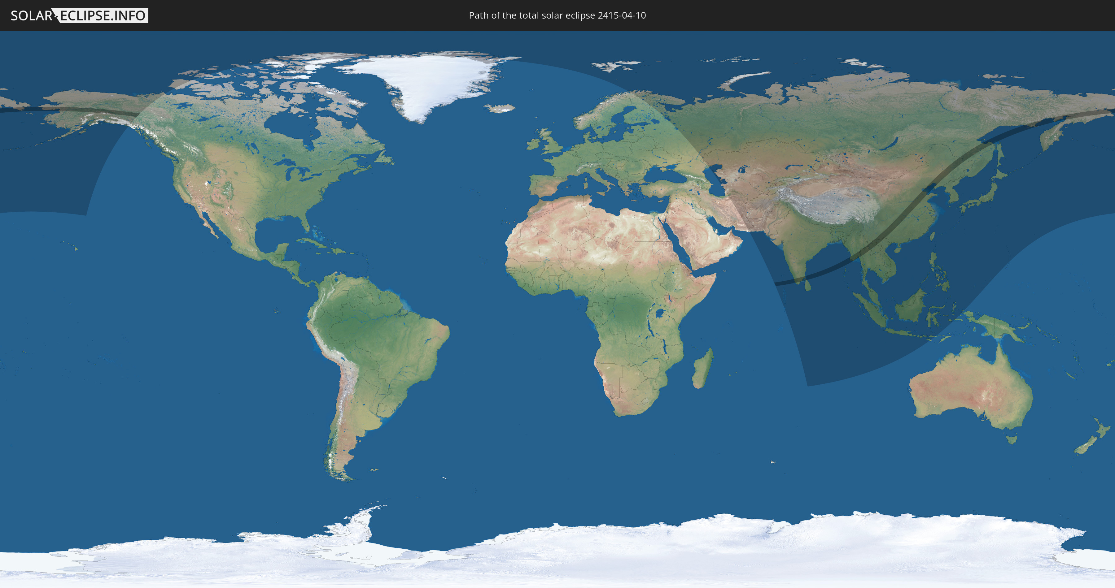
Die Sonnenfinsternis am 04/10/2415 kann man in 44 Ländern als partielle Sonnenfinsternis beobachten.
Der Finsternispfad verläuft durch 10 Länder. Nur in diesen Ländern ist sie als total Sonnenfinsternis zu sehen.
In den folgenden Ländern ist die Sonnenfinsternis total zu sehen
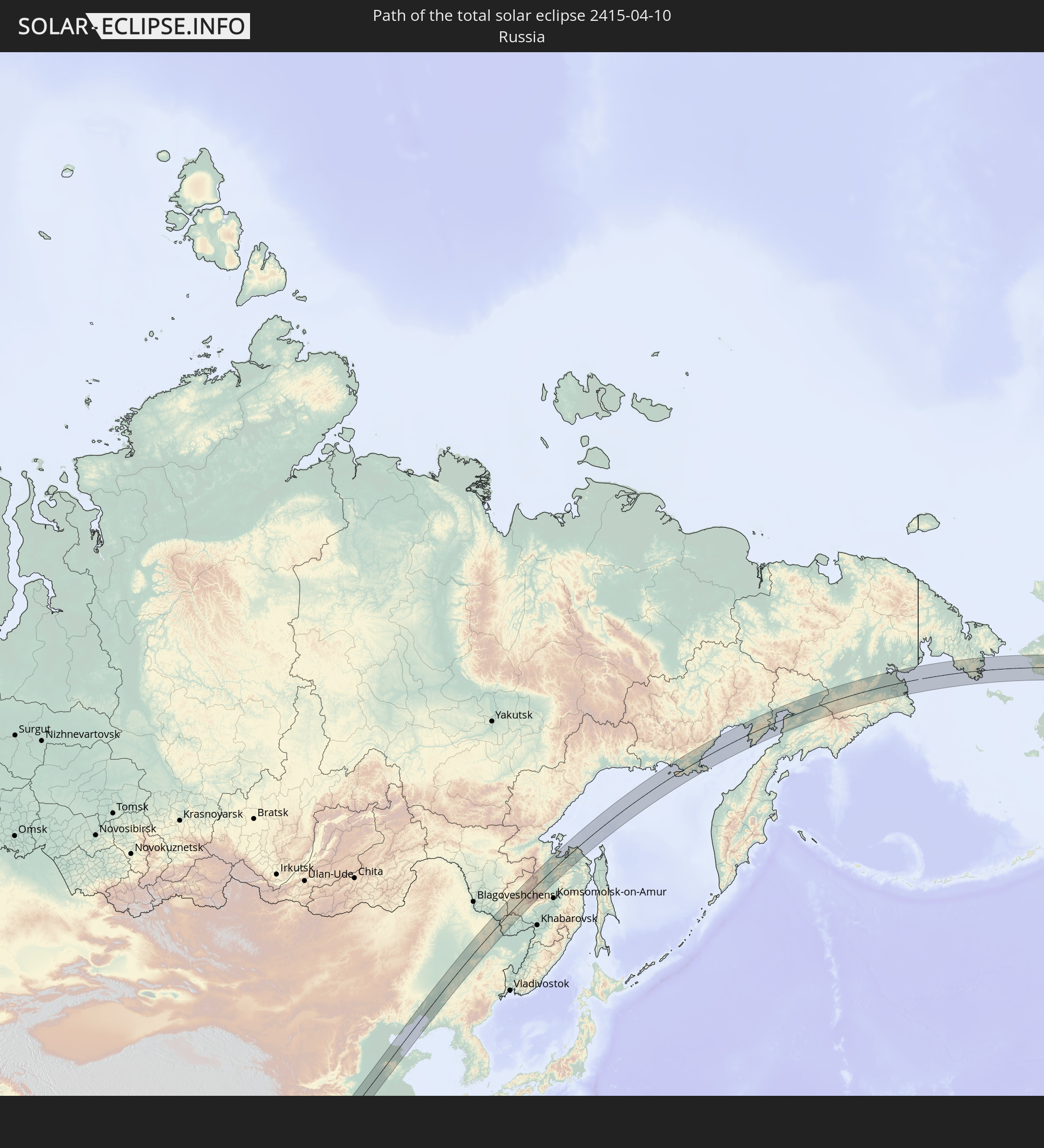 Russia
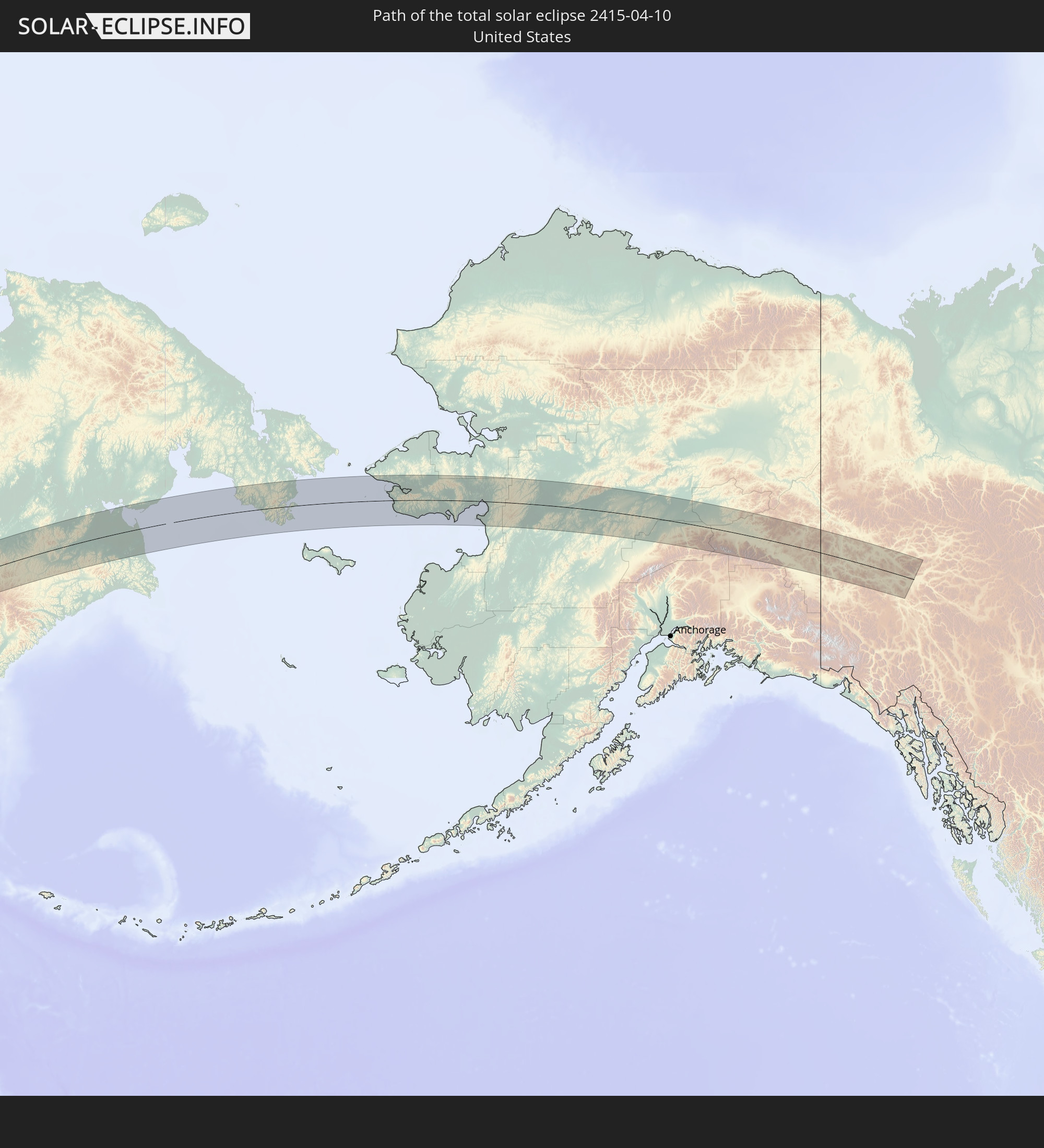 United States
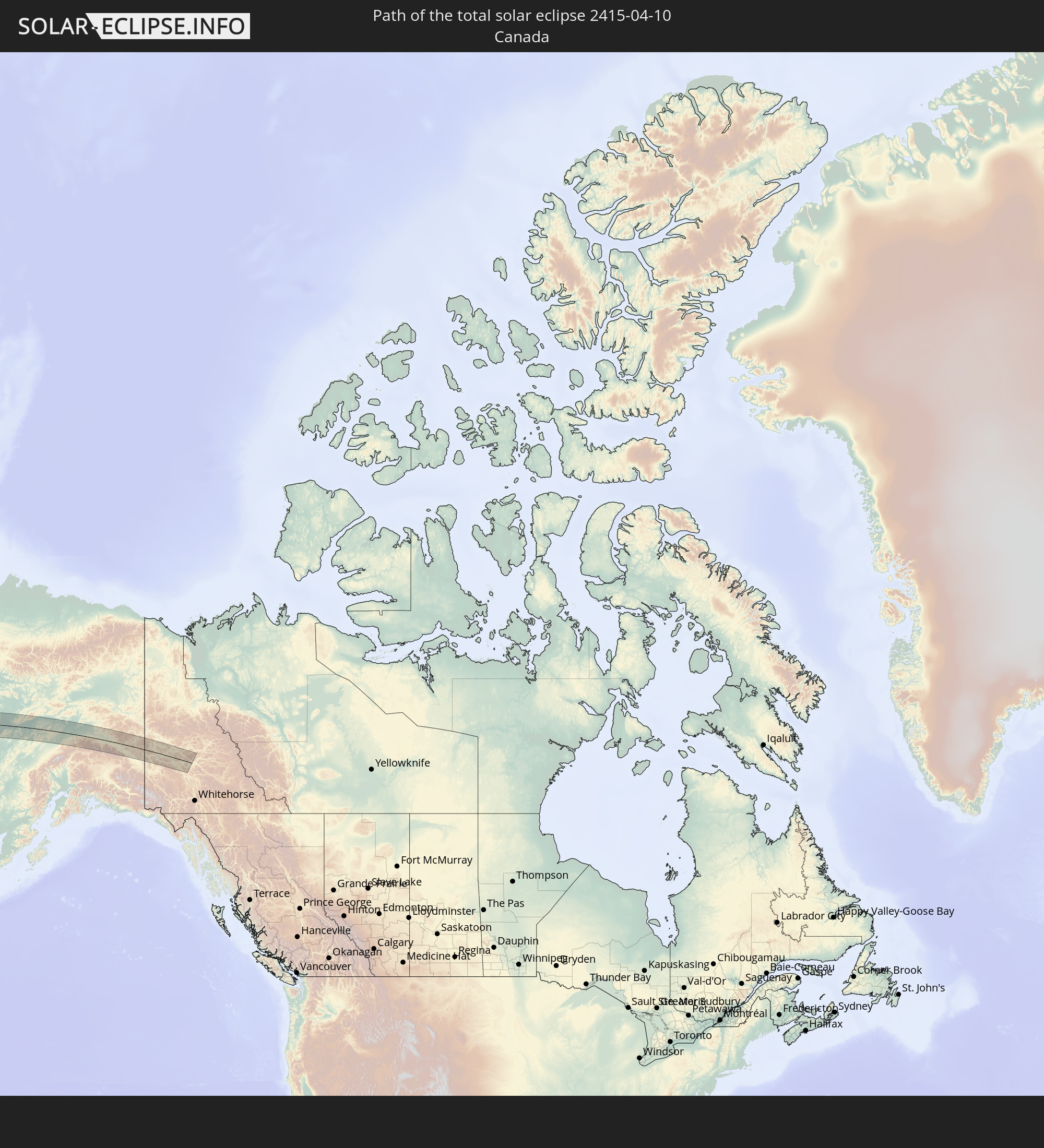 Canada
 India
India
 China
China
 Sri Lanka
 Myanmar
 Thailand
 Laos
Laos
 Vietnam
In den folgenden Ländern ist die Sonnenfinsternis partiell zu sehen
 Russia
 United States
 Canada
 Greenland
 Svalbard and Jan Mayen
 Norway
 Finland
 Iran
Iran
 Kazakhstan
 Turkmenistan
 Uzbekistan
 Afghanistan
 Pakistan
 Tajikistan
 India
India
 Kyrgyzstan
 Maldives
 China
China
 Sri Lanka
 Nepal
Nepal
 Mongolia
 Bangladesh
 Bhutan
 Myanmar
 Indonesia
 Cocos Islands
 Thailand
 Malaysia
 Laos
Laos
 Vietnam
 Cambodia
 Singapore
 Christmas Island
 Macau
Macau
 Hong Kong
 Brunei
 Taiwan
 Philippines
 Japan
Japan
 North Korea
 South Korea
 Palau
Palau
 Federated States of Micronesia
 Northern Mariana Islands
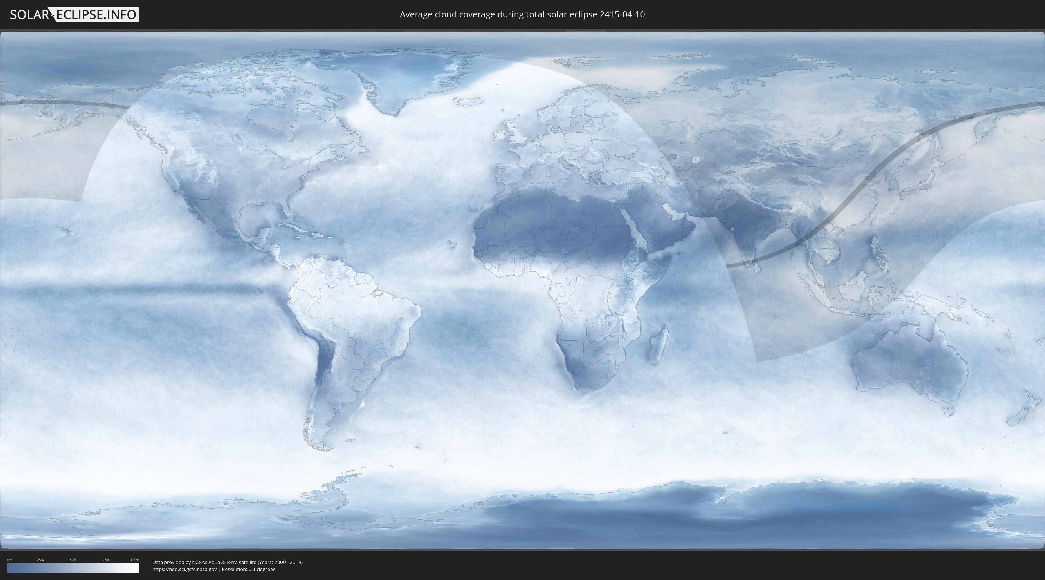
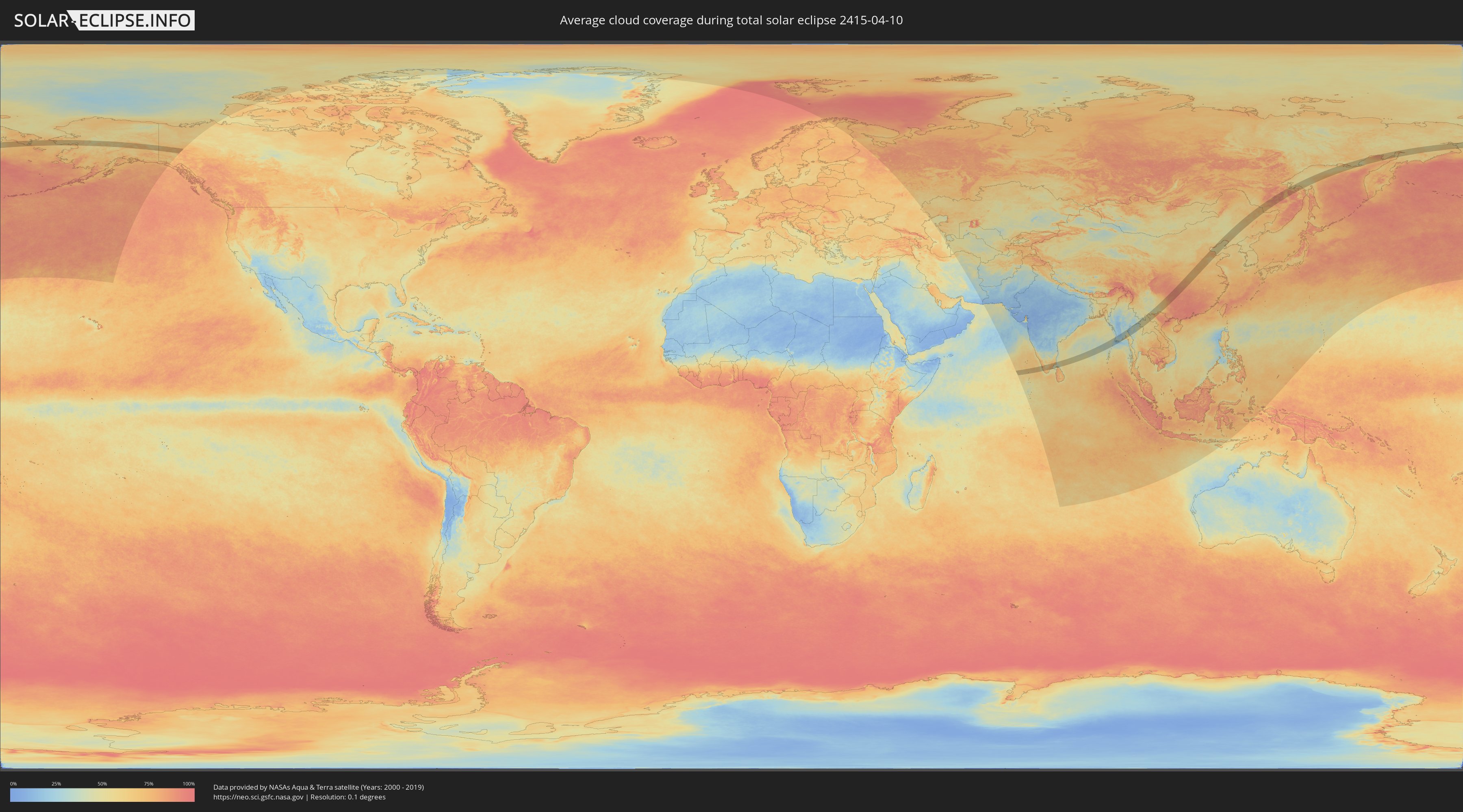
How will be the weather during the total solar eclipse on 04/10/2415?
Where is the best place to see the total solar eclipse of 04/10/2415?
The following maps show the average cloud coverage for the day of the total solar eclipse.
With the help of these maps, it is possible to find the place along the eclipse path, which has the best
chance of a cloudless sky.
Nevertheless, you should consider local circumstances and inform about the weather of your chosen
observation site.
The data is provided by NASAs satellites
AQUA and TERRA.
The cloud maps are averaged over a period of 19 years (2000 - 2019).
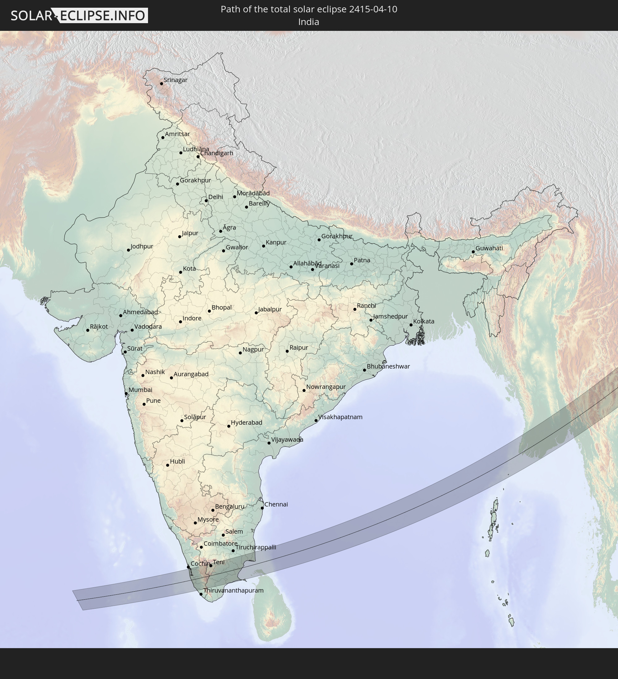
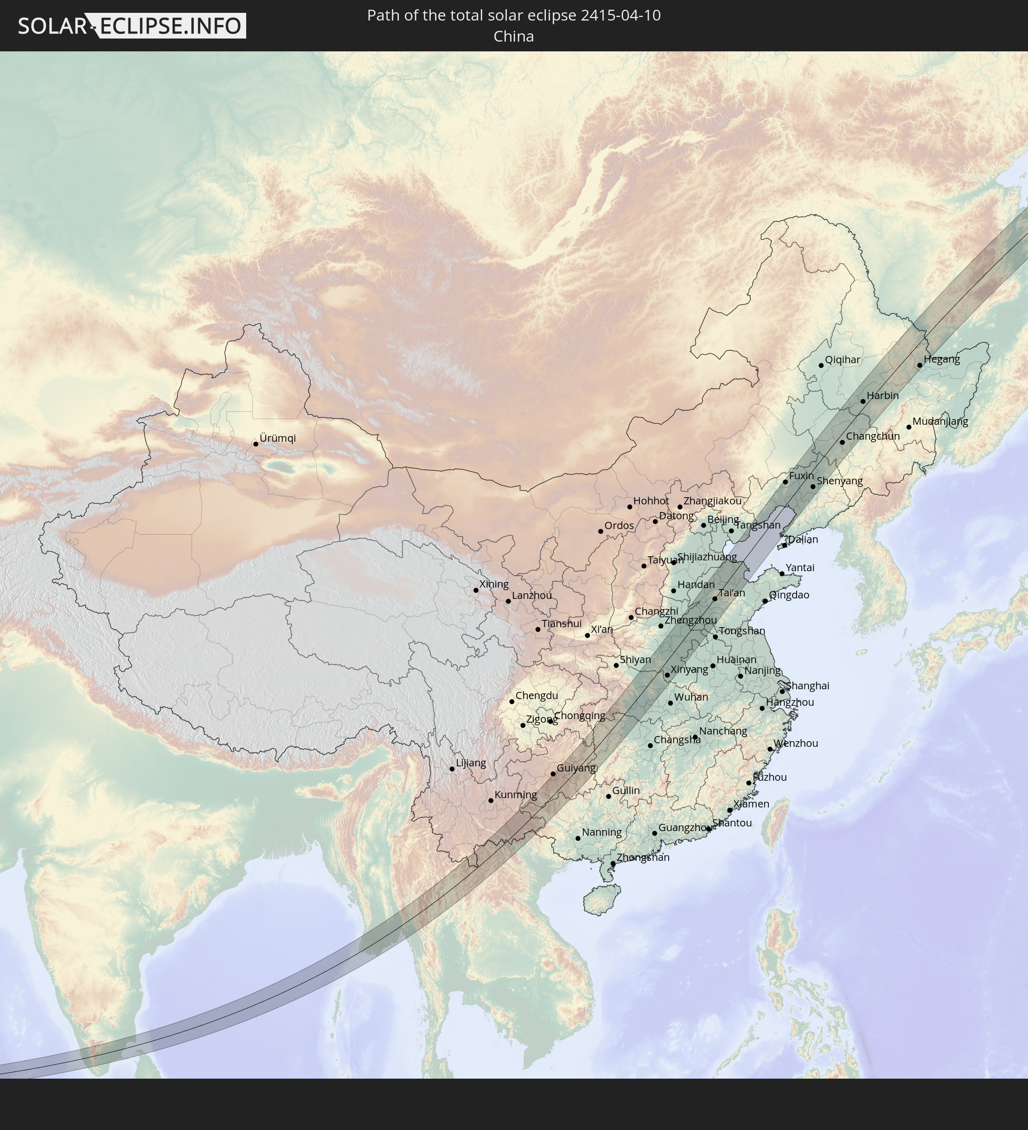
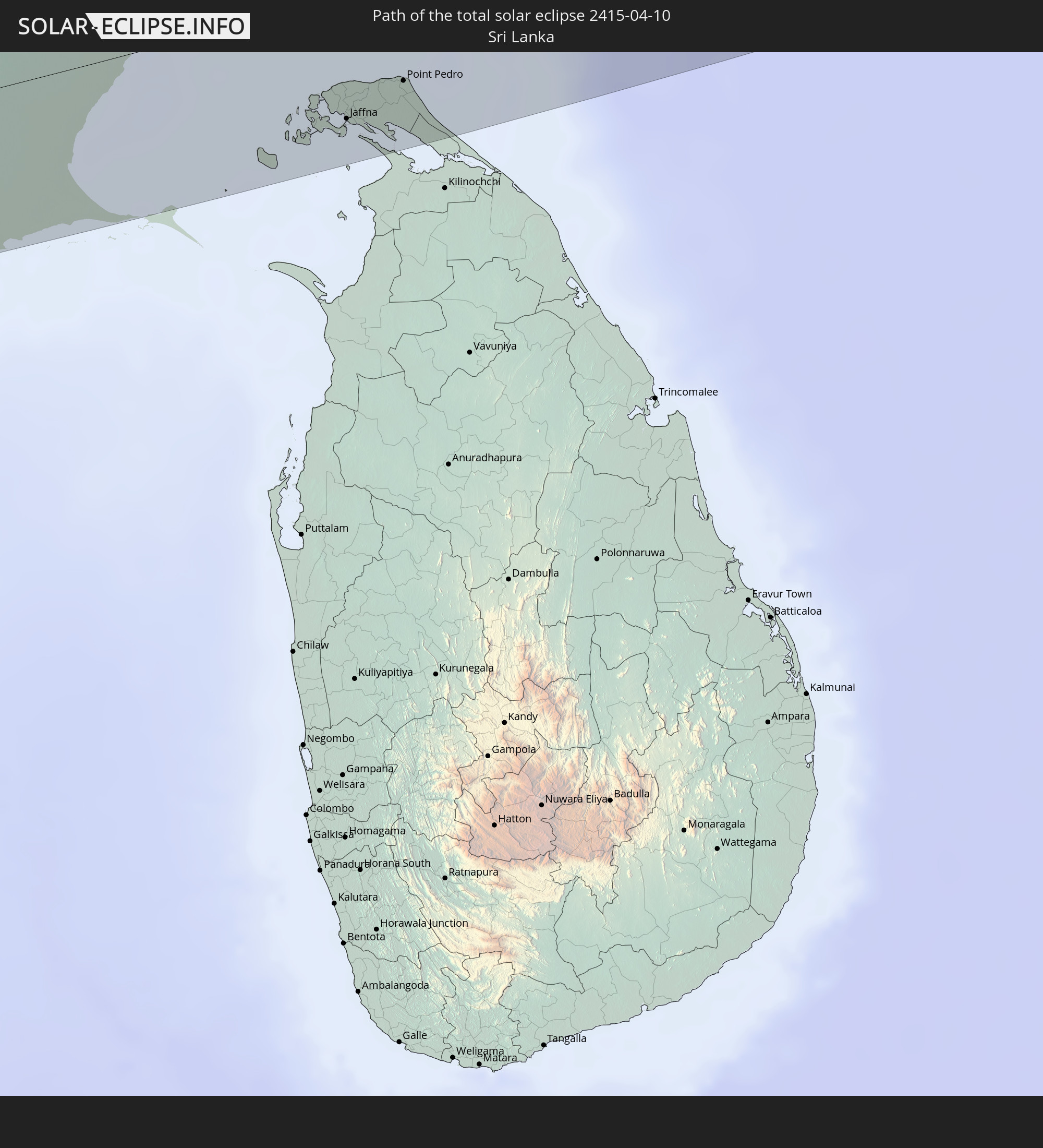
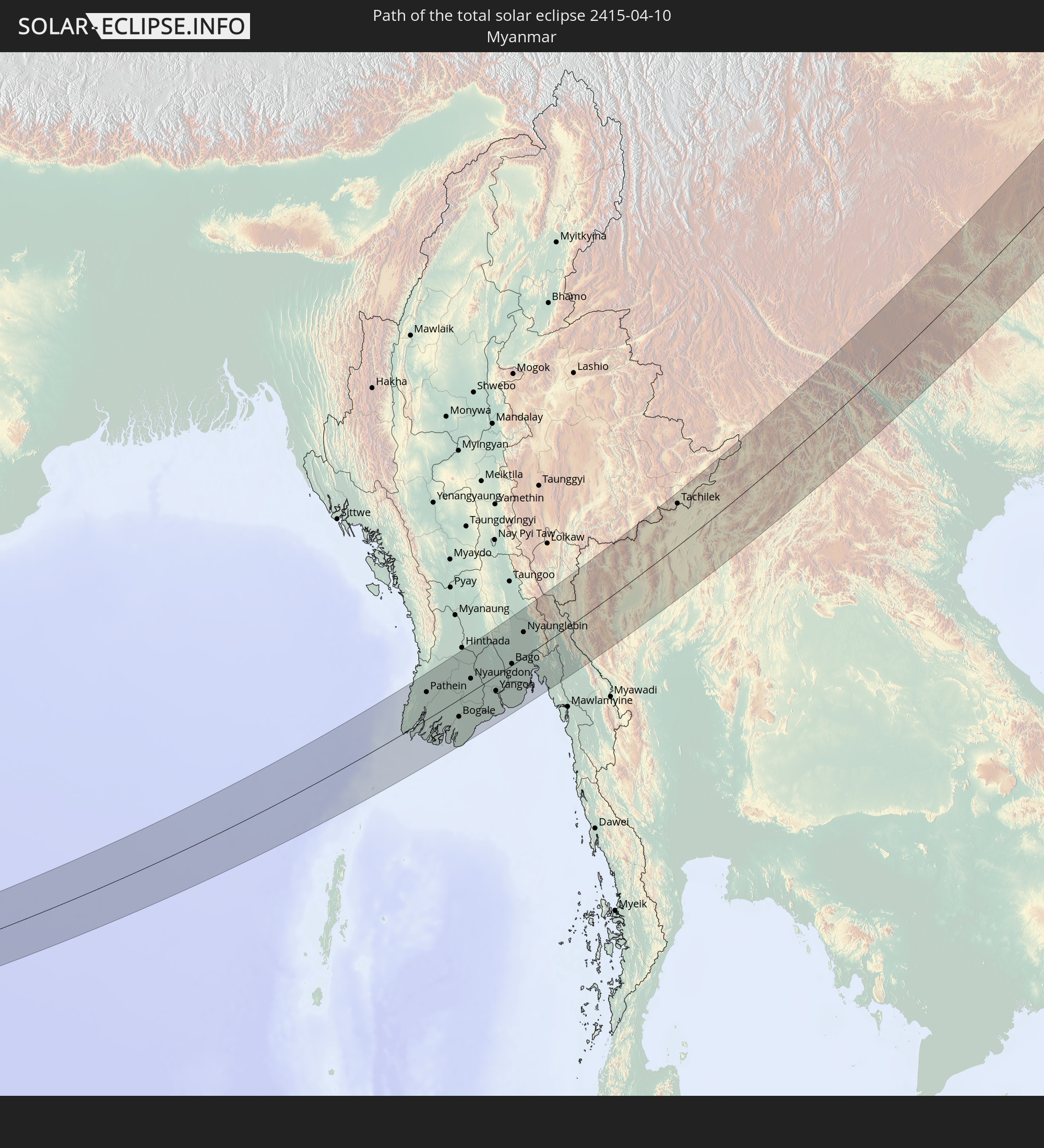
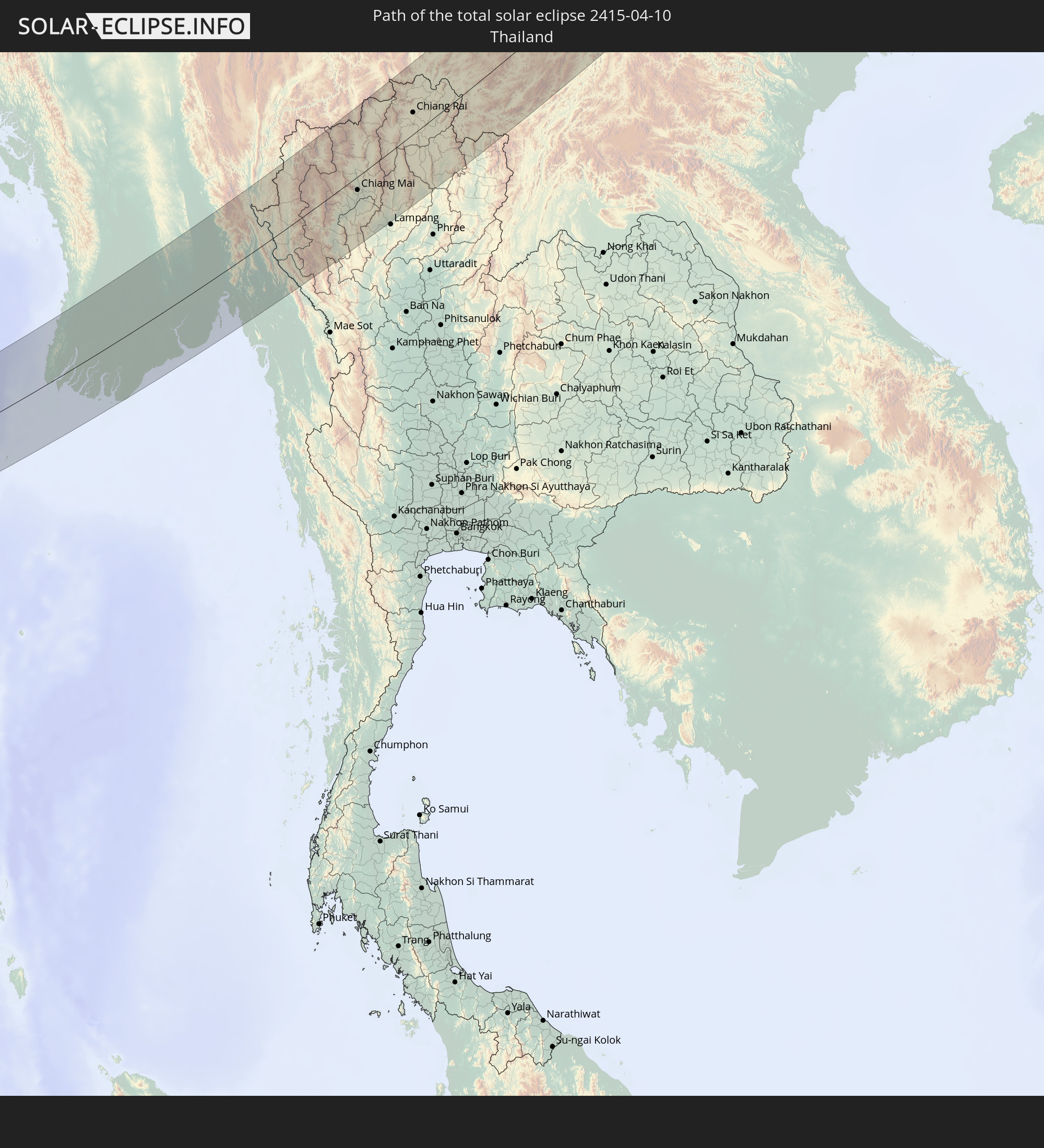
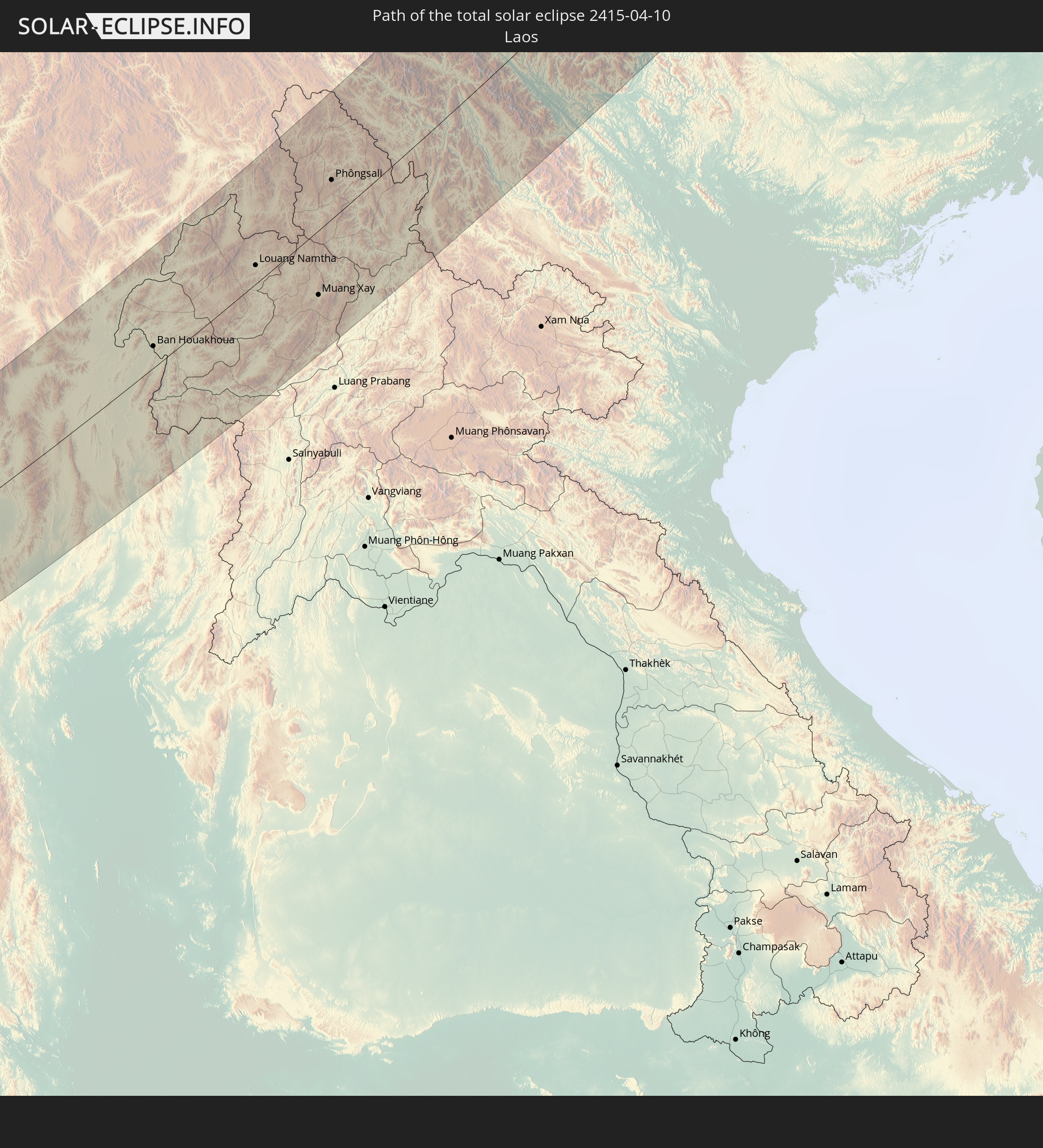
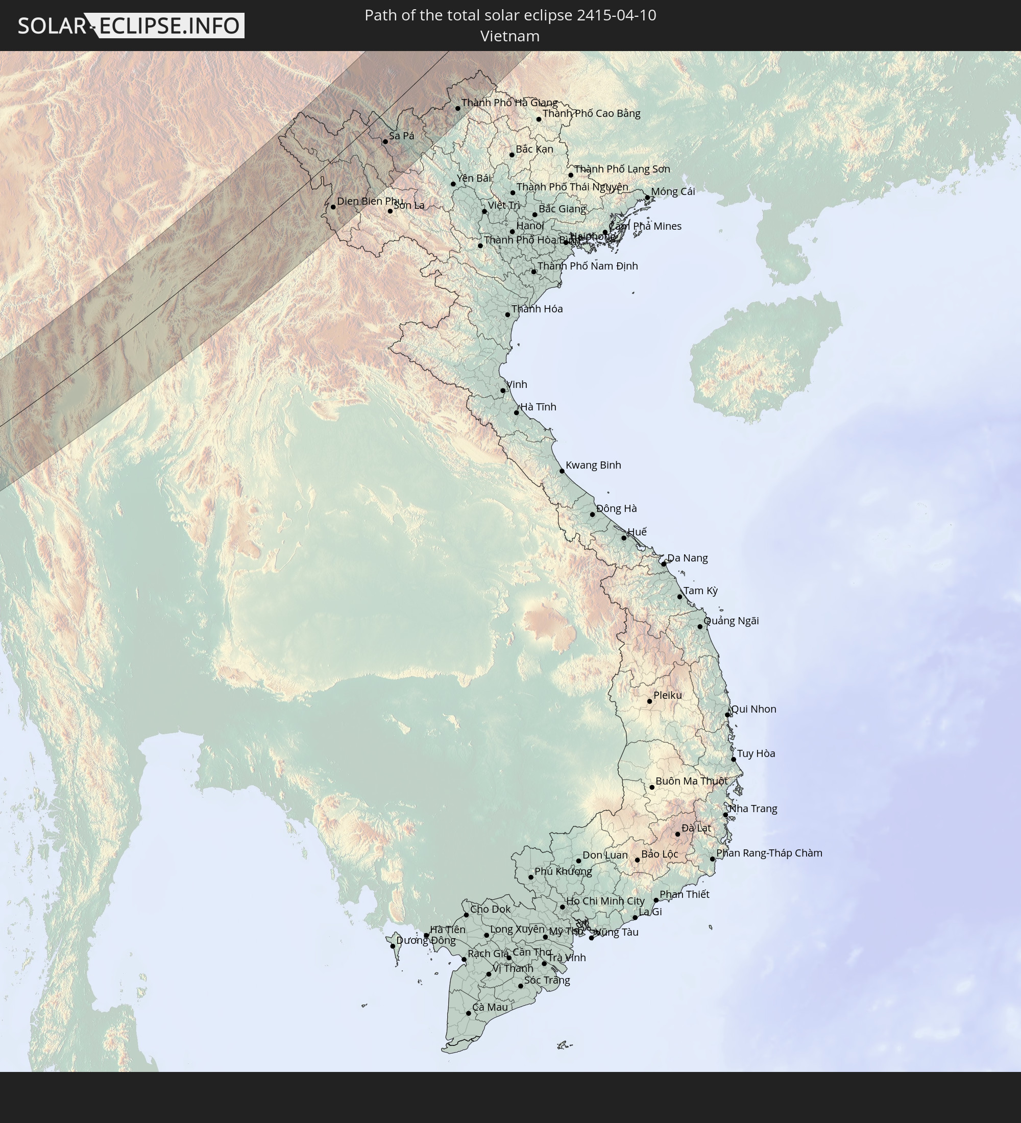
Detailed country maps
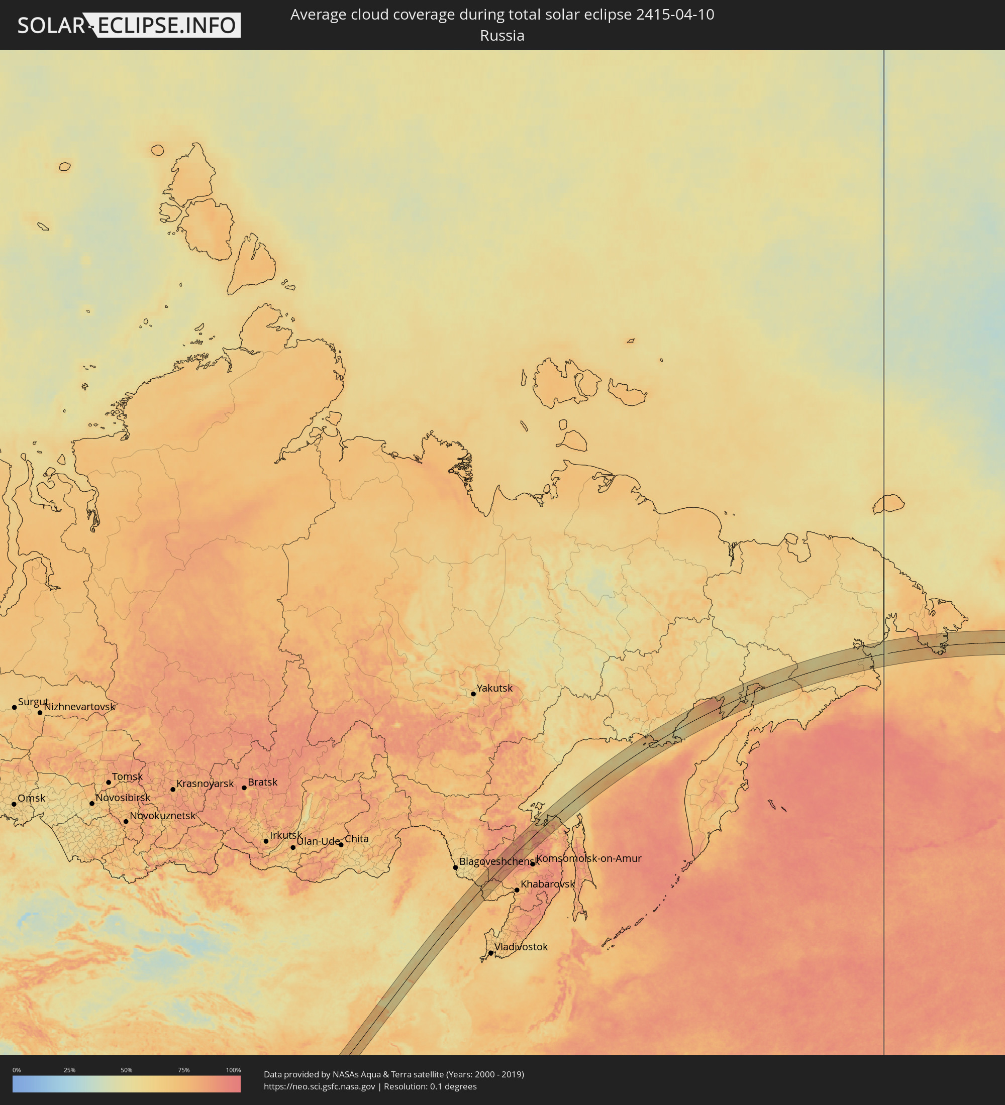 Russia
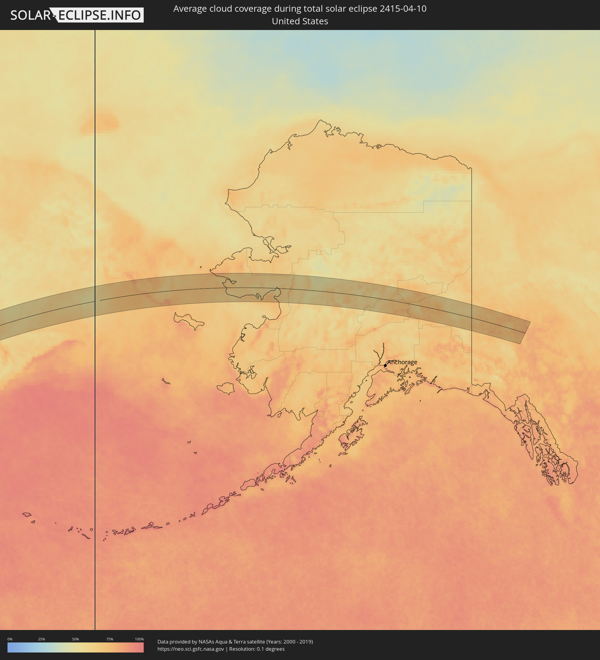 United States
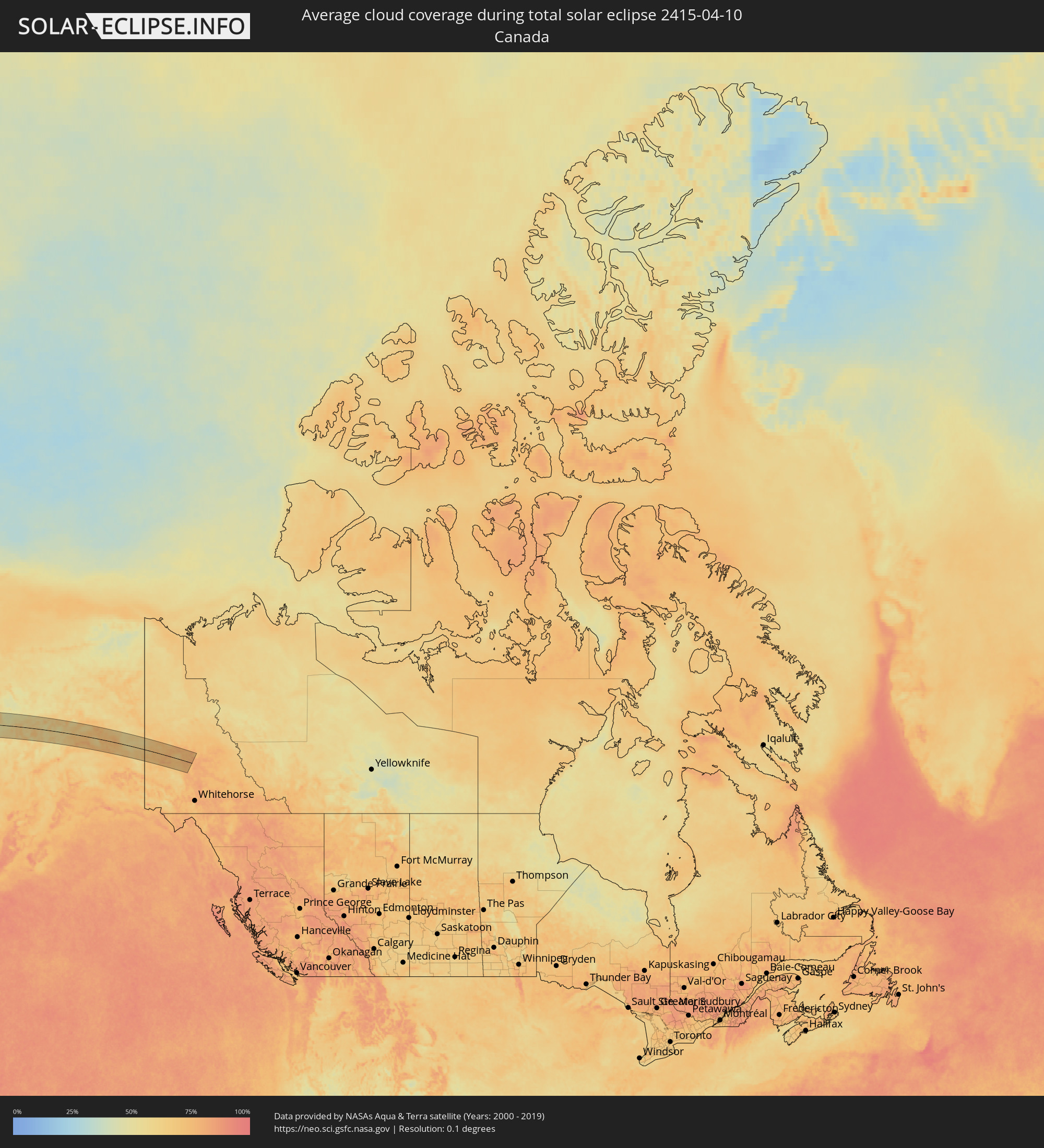 Canada
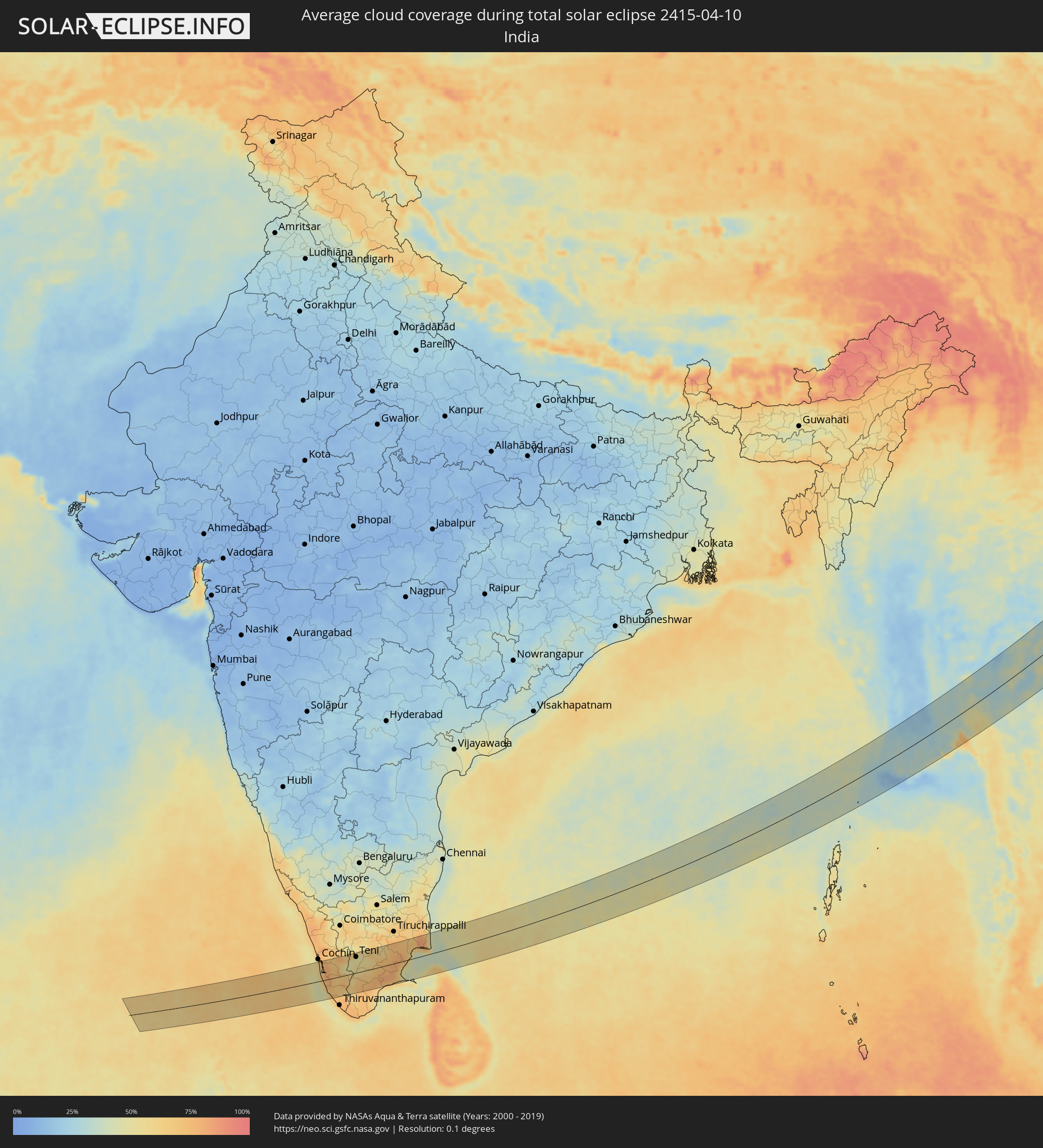 India
India
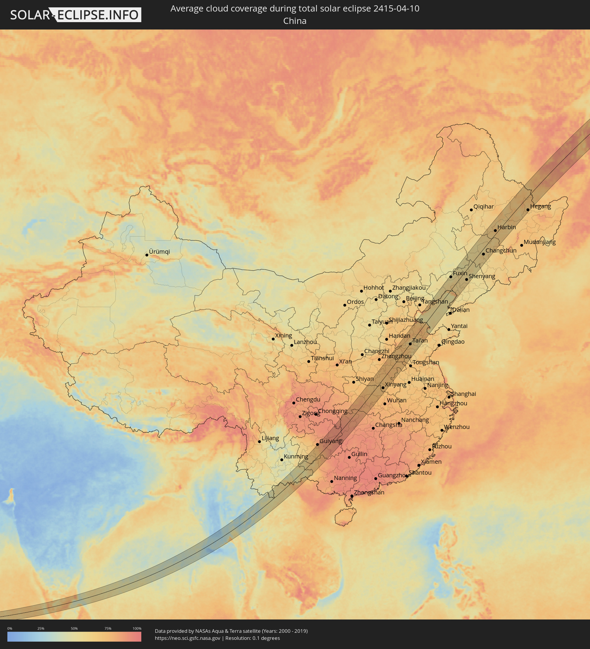 China
China
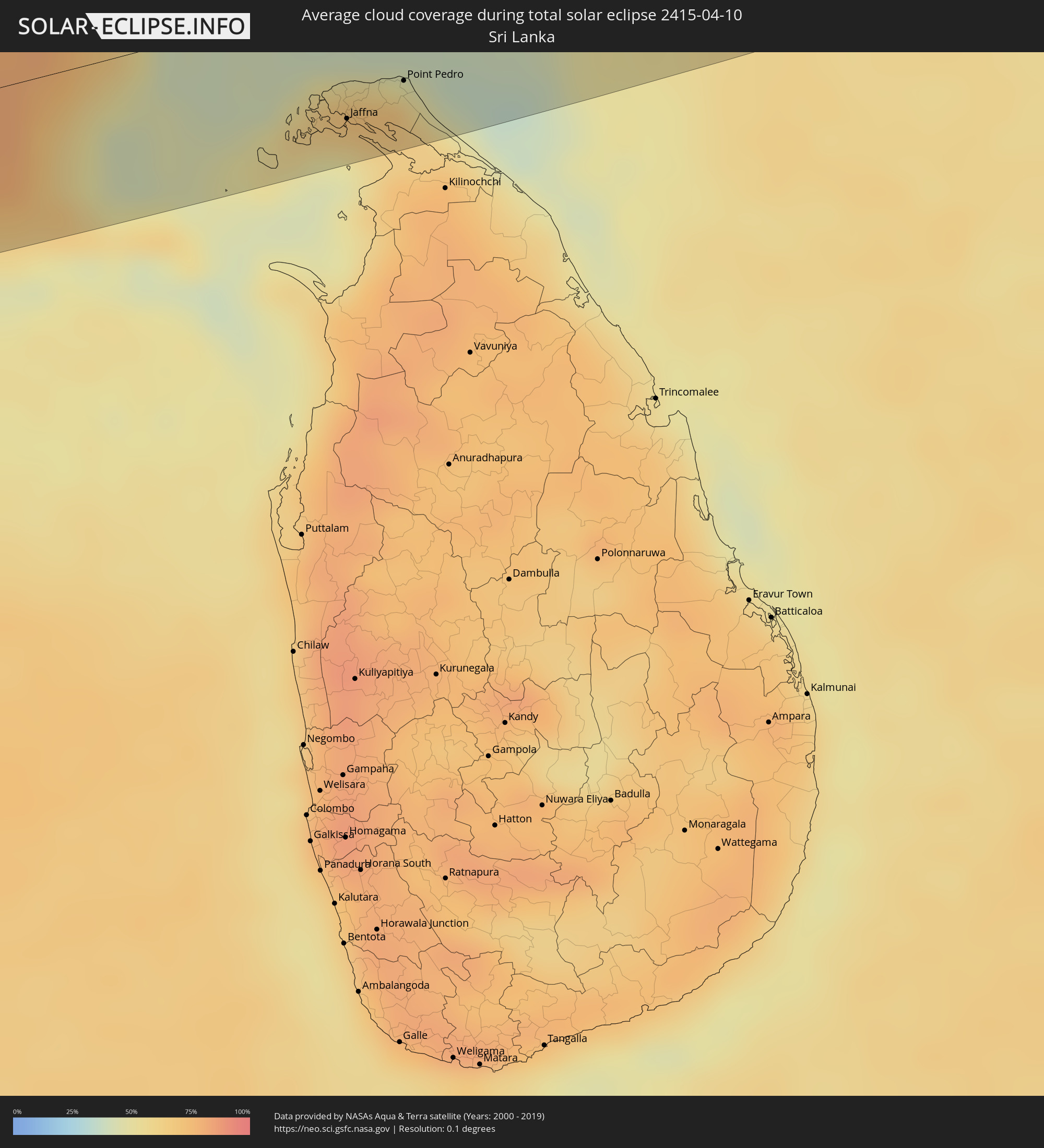 Sri Lanka
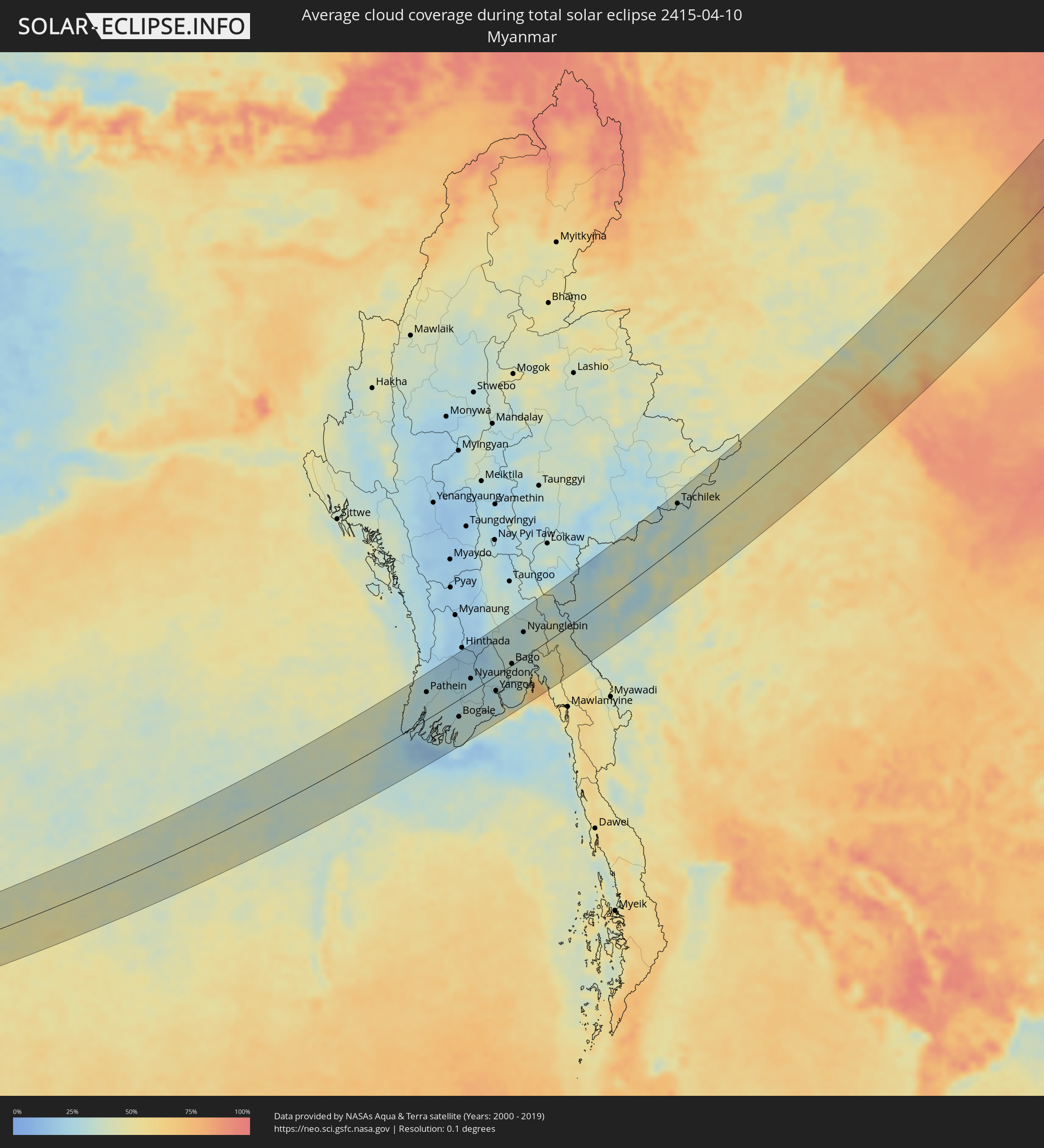 Myanmar
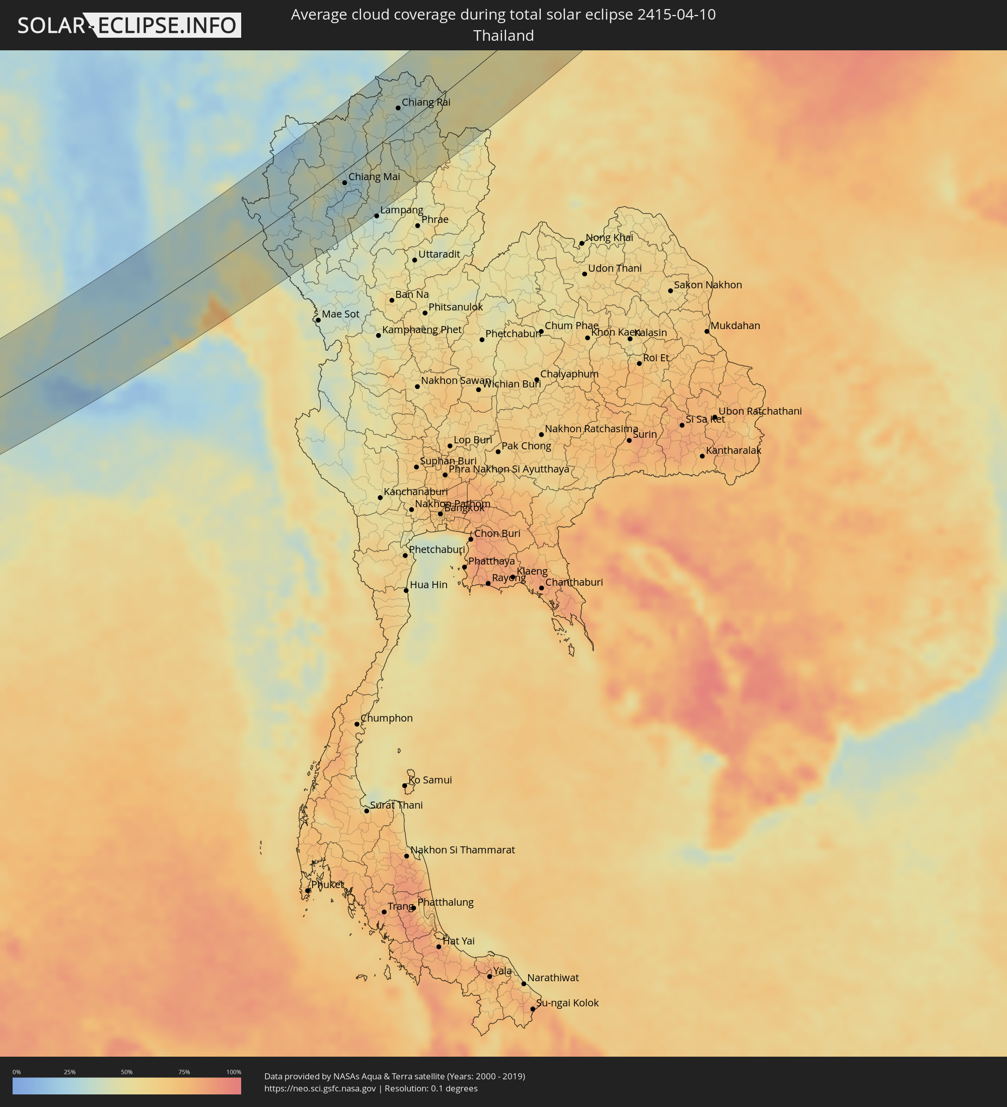 Thailand
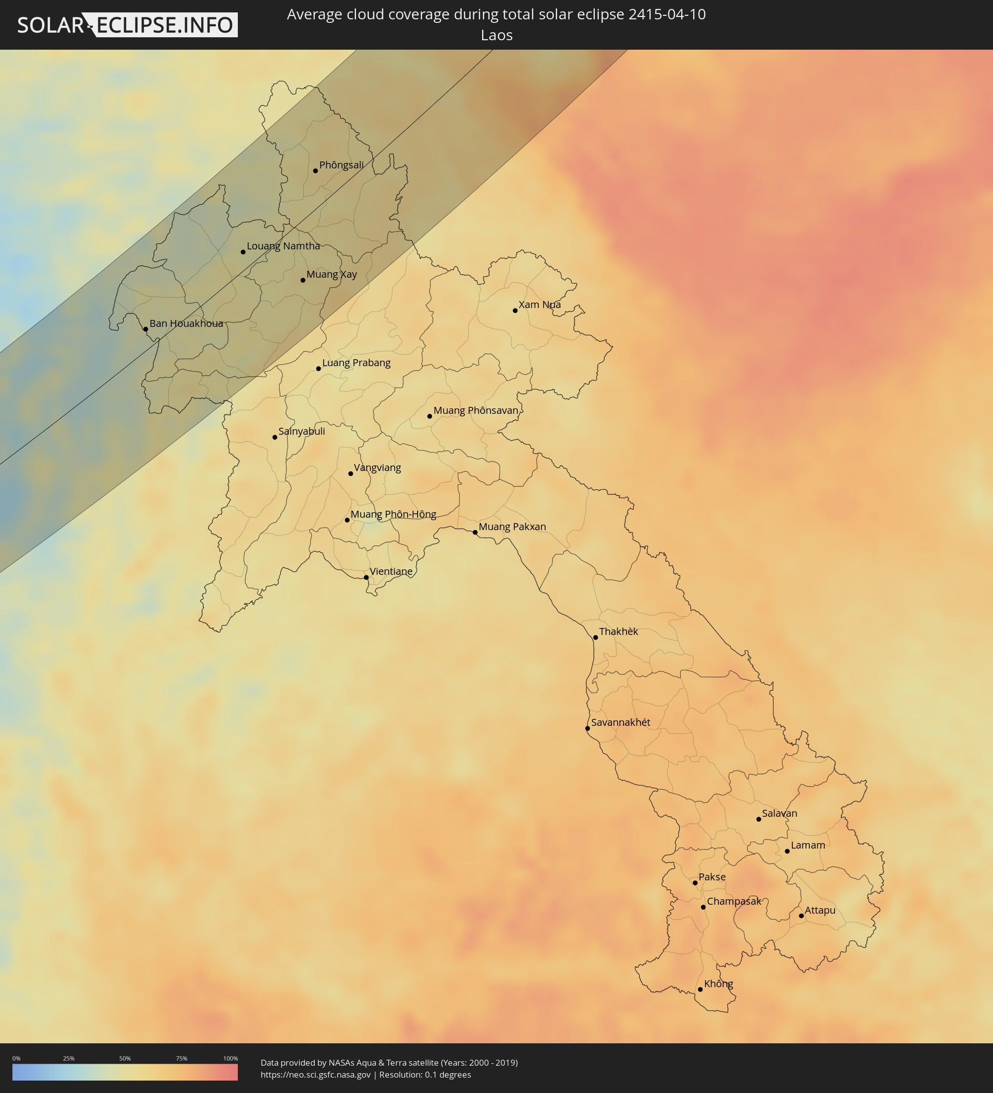 Laos
Laos
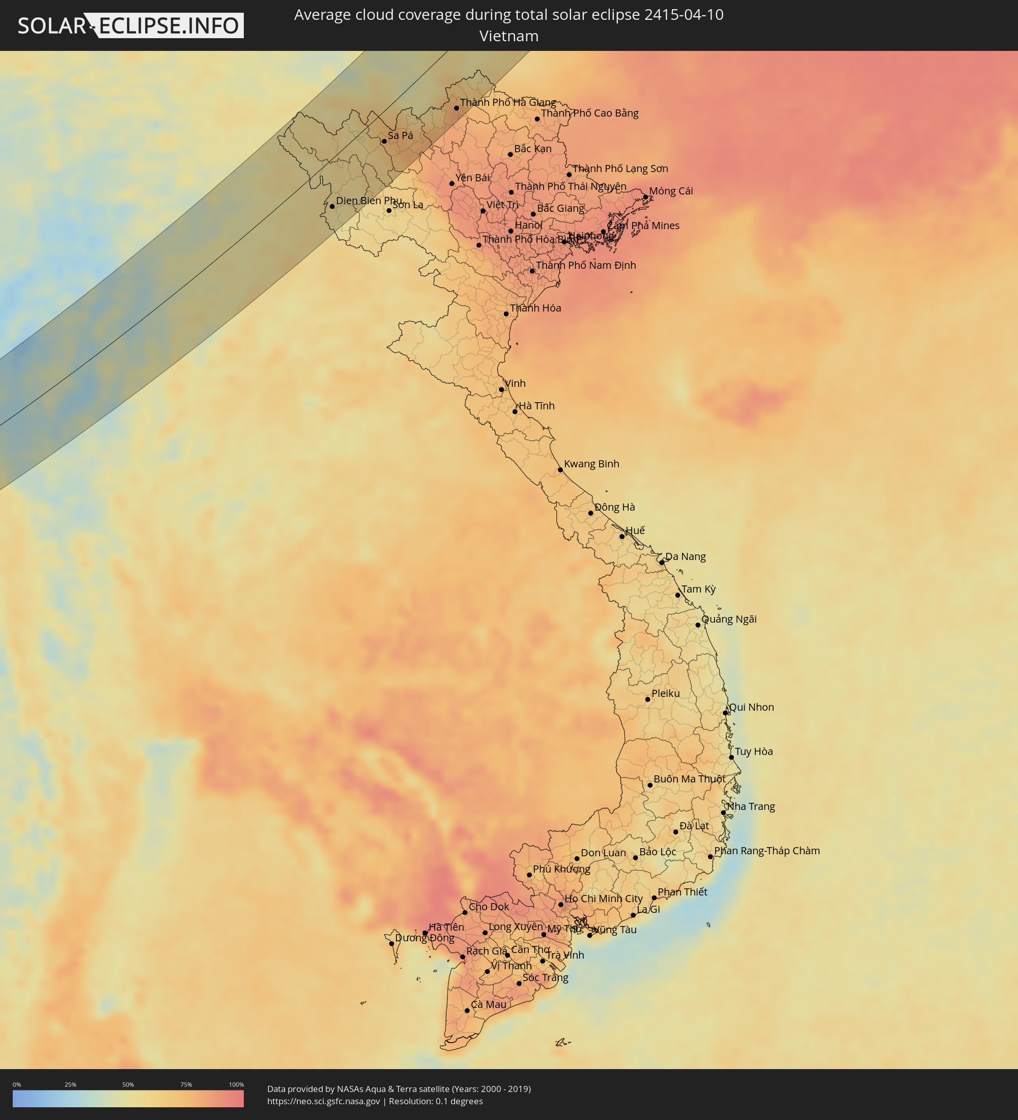 Vietnam
Cities inside the path of the eclipse
The following table shows all locations with a population of more than 5,000 inside the eclipse path. Cities which have more than 100,000 inhabitants are marked bold. A click at the locations opens a detailed map.
| City | Type | Eclipse duration | Local time of max. eclipse | Distance to central line | Ø Cloud coverage |
|
Alleppey, Kerala
|
total | - | 06:47:27 UTC+05:30 | 26 km | 57% |
|
Cherthala, Kerala
|
total | - | 06:47:41 UTC+05:30 | 47 km | 60% |
|
Kāyankulam, Kerala
|
total | - | 06:47:04 UTC+05:30 | 13 km | 66% |
|
Kottayam, Kerala
|
total | - | 06:47:34 UTC+05:30 | 32 km | 77% |
|
Tiruvalla, Kerala
|
total | - | 06:47:20 UTC+05:30 | 8 km | 78% |
|
Kollam, Kerala
|
total | - | 06:46:44 UTC+05:30 | 46 km | 62% |
|
Varkala, Kerala
|
total | - | 06:46:33 UTC+05:30 | 66 km | 57% |
|
Punalūr, Kerala
|
total | - | 06:46:54 UTC+05:30 | 40 km | 67% |
|
Cumbum, Tamil Nadu
|
total | - | 06:47:47 UTC+05:30 | 29 km | 54% |
|
Kadayanallur, Tamil Nadu
|
total | - | 06:46:59 UTC+05:30 | 44 km | 60% |
|
Teni, Tamil Nadu
|
total | - | 06:48:08 UTC+05:30 | 54 km | 52% |
|
Rajapalaiyam, Tamil Nadu
|
total | - | 06:47:27 UTC+05:30 | 8 km | 67% |
|
Sivakasi, Tamil Nadu
|
total | - | 06:47:27 UTC+05:30 | 15 km | 70% |
|
Kovilpatti, Tamil Nadu
|
total | - | 06:47:07 UTC+05:30 | 47 km | 76% |
|
Virudunagar, Tamil Nadu
|
total | - | 06:47:37 UTC+05:30 | 4 km | 69% |
|
Aruppukkottai, Tamil Nadu
|
total | - | 06:47:32 UTC+05:30 | 16 km | 75% |
|
Madurai, Tamil Nadu
|
total | - | 06:48:03 UTC+05:30 | 27 km | 64% |
|
Sivaganga, Tamil Nadu
|
total | - | 06:47:59 UTC+05:30 | 10 km | 74% |
|
Paramagudi, Tamil Nadu
|
total | - | 06:47:37 UTC+05:30 | 25 km | 79% |
|
Kāraikkudi, Tamil Nadu
|
total | - | 06:48:17 UTC+05:30 | 26 km | 79% |
|
Pudukkottai, Tamil Nadu
|
total | - | 06:48:41 UTC+05:30 | 58 km | 72% |
|
Ramanathapuram, Tamil Nadu
|
total | - | 06:47:25 UTC+05:30 | 51 km | 68% |
|
Pattukkottai, Tamil Nadu
|
total | - | 06:48:47 UTC+05:30 | 49 km | 64% |
|
Mannargudi, Tamil Nadu
|
total | - | 06:49:06 UTC+05:30 | 71 km | 83% |
|
Nāgappattinam, Tamil Nadu
|
total | - | 06:49:16 UTC+05:30 | 71 km | 59% |
|
Jaffna, Northern Province
|
total | - | 06:47:54 UTC+05:30 | 52 km | 64% |
|
Valvedditturai, Northern Province
|
total | - | 06:48:06 UTC+05:30 | 40 km | 67% |
|
Point Pedro, Northern Province
|
total | - | 06:48:07 UTC+05:30 | 42 km | 67% |
|
Pathein, Ayeyarwady
|
total | - | 08:03:35 UTC+06:30 | 51 km | 29% |
|
Wakema, Ayeyarwady
|
total | - | 08:03:34 UTC+06:30 | 9 km | 29% |
|
Mawlamyinegyunn, Ayeyarwady
|
total | - | 08:03:14 UTC+06:30 | 17 km | 29% |
|
Bogale, Ayeyarwady
|
total | - | 08:03:11 UTC+06:30 | 32 km | 33% |
|
Nyaungdon, Ayeyarwady
|
total | - | 08:04:36 UTC+06:30 | 24 km | 26% |
|
Maubin, Ayeyarwady
|
total | - | 08:04:04 UTC+06:30 | 6 km | 31% |
|
Pyapon, Ayeyarwady
|
total | - | 08:03:20 UTC+06:30 | 49 km | 32% |
|
Kyaiklat, Ayeyarwady
|
total | - | 08:03:38 UTC+06:30 | 37 km | 31% |
|
Letpandan, Bago
|
total | - | 08:05:56 UTC+06:30 | 87 km | 19% |
|
Tharyarwady, Bago
|
total | - | 08:05:43 UTC+06:30 | 73 km | 18% |
|
Twante, Yangon
|
total | - | 08:04:13 UTC+06:30 | 24 km | 29% |
|
Kanbe, Yangon
|
total | - | 08:04:15 UTC+06:30 | 28 km | 30% |
|
Yangon, Yangon
|
total | - | 08:04:31 UTC+06:30 | 28 km | 33% |
|
Syriam, Yangon
|
total | - | 08:04:31 UTC+06:30 | 36 km | 33% |
|
Thanatpin, Bago
|
total | - | 08:05:19 UTC+06:30 | 2 km | 32% |
|
Bago, Bago
|
total | - | 08:05:38 UTC+06:30 | 3 km | 35% |
|
Thongwa, Yangon
|
total | - | 08:04:41 UTC+06:30 | 53 km | 36% |
|
Kayan, Yangon
|
total | - | 08:04:58 UTC+06:30 | 42 km | 39% |
|
Thanatpin, Bago
|
total | - | 08:05:38 UTC+06:30 | 7 km | 34% |
|
Nyaunglebin, Bago
|
total | - | 08:06:52 UTC+06:30 | 45 km | 30% |
|
Kyaikto, Mon
|
total | - | 08:05:57 UTC+06:30 | 31 km | 39% |
|
Pa Pae, Mae Hong Son
|
total | - | 08:38:20 UTC+07:00 | 7 km | 27% |
|
Chom Thong, Chiang Mai
|
total | - | 08:39:04 UTC+07:00 | 31 km | 30% |
|
San Pa Tong, Chiang Mai
|
total | - | 08:39:36 UTC+07:00 | 26 km | 26% |
|
Hang Dong, Chiang Mai
|
total | - | 08:39:44 UTC+07:00 | 22 km | 26% |
|
Pa Sang, Lamphun
|
total | - | 08:39:27 UTC+07:00 | 38 km | 28% |
|
Chiang Mai, Chiang Mai
|
total | - | 08:39:58 UTC+07:00 | 17 km | 28% |
|
Lamphun, Lamphun
|
total | - | 08:39:36 UTC+07:00 | 38 km | 28% |
|
San Kamphaeng, Chiang Mai
|
total | - | 08:39:59 UTC+07:00 | 30 km | 25% |
|
Mae Tha, Lamphun
|
total | - | 08:39:30 UTC+07:00 | 56 km | 33% |
|
Fang, Chiang Mai
|
total | - | 08:42:09 UTC+07:00 | 68 km | 31% |
|
Mae Chai, Phayao
|
total | - | 08:41:36 UTC+07:00 | 21 km | 39% |
|
Chiang Rai, Chiang Rai
|
total | - | 08:42:38 UTC+07:00 | 27 km | 33% |
|
Mae Chan, Chiang Rai
|
total | - | 08:43:04 UTC+07:00 | 47 km | 33% |
|
Mae Sai, Chiang Rai
|
total | - | 08:43:37 UTC+07:00 | 70 km | 35% |
|
Phayao, Phayao
|
total | - | 08:41:22 UTC+07:00 | 39 km | 40% |
|
Tachilek, Shan
|
total | - | 08:43:39 UTC+07:00 | 71 km | 35% |
|
Pa Daet, Chiang Rai
|
total | - | 08:42:01 UTC+07:00 | 18 km | 38% |
|
Dok Kham Tai, Phayao
|
total | - | 08:41:24 UTC+07:00 | 49 km | 41% |
|
Chiang Saen, Chiang Rai
|
total | - | 08:43:30 UTC+07:00 | 43 km | 32% |
|
Pong, Phayao
|
total | - | 08:41:36 UTC+07:00 | 68 km | 46% |
|
Chiang Kham, Phayao
|
total | - | 08:42:18 UTC+07:00 | 37 km | 41% |
|
Chiang Khong, Chiang Rai
|
total | - | 08:43:44 UTC+07:00 | 21 km | 40% |
|
Ban Houayxay, Bokeo Province
|
total | - | 08:43:46 UTC+07:00 | 22 km | 40% |
|
Ban Houakhoua, Bokeo Province
|
total | - | 08:43:45 UTC+07:00 | 16 km | 41% |
|
Louang Namtha, Loungnamtha
|
total | - | 08:45:49 UTC+07:00 | 14 km | 48% |
|
Muang Xay, Oudômxai
|
total | - | 08:45:51 UTC+07:00 | 47 km | 52% |
|
Phôngsali, Phôngsali
|
total | - | 08:47:48 UTC+07:00 | 28 km | 54% |
|
Dien Bien Phu, Tỉnh Ðiện Biên
|
total | - | 08:48:03 UTC+07:00 | 59 km | 53% |
|
Lai Châu, Lai Châu
|
total | - | 08:50:22 UTC+07:00 | 6 km | 56% |
|
Sa Pá, Lào Cai
|
total | - | 08:50:37 UTC+07:00 | 37 km | 67% |
|
Lào Cai, Lào Cai
|
total | - | 08:51:00 UTC+07:00 | 34 km | 77% |
|
Wenshan City, Yunnan
|
total | - | 09:52:57 UTC+08:00 | 17 km | 43% |
|
Thành Phố Hà Giang, Hà Giang
|
total | - | 08:52:37 UTC+07:00 | 78 km | 81% |
|
Guiyang, Guizhou
|
total | - | 10:01:41 UTC+08:00 | 90 km | 79% |
|
Yichang, Hubei
|
total | - | 10:14:57 UTC+08:00 | 50 km | 80% |
|
Xiangyang, Hubei
|
total | - | 10:18:35 UTC+08:00 | 78 km | 74% |
|
Shashi, Hubei
|
total | - | 10:15:16 UTC+08:00 | 50 km | 79% |
|
Zhumadian, Henan
|
total | - | 10:22:43 UTC+08:00 | 2 km | 75% |
|
Luohe, Henan
|
total | - | 10:23:53 UTC+08:00 | 41 km | 75% |
|
Xinyang, Henan
|
total | - | 10:21:05 UTC+08:00 | 59 km | 70% |
|
Jining, Shandong
|
total | - | 10:30:38 UTC+08:00 | 20 km | 72% |
|
Jinan, Shandong
|
total | - | 10:33:34 UTC+08:00 | 35 km | 68% |
|
Tai’an, Shandong
|
total | - | 10:32:49 UTC+08:00 | 6 km | 65% |
|
Zibo, Shandong
|
total | - | 10:35:10 UTC+08:00 | 32 km | 65% |
|
Qinhuangdao, Hebei
|
total | - | 10:42:53 UTC+08:00 | 72 km | 66% |
|
Jinzhou, Liaoning
|
total | - | 10:46:57 UTC+08:00 | 46 km | 58% |
|
Fuxin, Liaoning
|
total | - | 10:49:09 UTC+08:00 | 73 km | 52% |
|
Panshan, Liaoning
|
total | - | 10:48:16 UTC+08:00 | 9 km | 62% |
|
Yingkou, Liaoning
|
total | - | 10:47:37 UTC+08:00 | 57 km | 72% |
|
Anshan, Liaoning
|
total | - | 10:49:25 UTC+08:00 | 76 km | 61% |
|
Liaoyang, Liaoning
|
total | - | 10:49:54 UTC+08:00 | 78 km | 60% |
|
Shenyang, Liaoning
|
total | - | 10:51:07 UTC+08:00 | 59 km | 62% |
|
Fushun, Liaoning
|
total | - | 10:51:52 UTC+08:00 | 86 km | 57% |
|
Siping, Jilin
|
total | - | 10:54:35 UTC+08:00 | 24 km | 57% |
|
Changchun, Jilin
|
total | - | 10:56:57 UTC+08:00 | 33 km | 64% |
|
Harbin, Heilongjiang
|
total | - | 11:01:28 UTC+08:00 | 18 km | 71% |
|
Hegang, Heilongjiang
|
total | - | 11:08:21 UTC+08:00 | 76 km | 70% |
|
Novyy Urgal, Khabarovsk Krai
|
total | - | 13:15:31 UTC+10:00 | 83 km | 73% |
|
Chegdomyn, Khabarovsk Krai
|
total | - | 13:16:04 UTC+10:00 | 67 km | 77% |
|
Berëzovyy, Khabarovsk Krai
|
total | - | 13:19:46 UTC+10:00 | 22 km | 85% |
|
Magadan, Magadan
|
total | - | 14:39:36 UTC+11:00 | 75 km | 65% |
|
Ola, Magadan
|
total | - | 14:40:02 UTC+11:00 | 62 km | 75% |
|
Anadyr, Chukotskiy Avtonomnyy Okrug
|
total | - | 15:55:46 UTC+12:00 | 73 km | 61% |