Annular solar eclipse of 05/31/2421
| Day of week: | Monday |
| Maximum duration of eclipse: | 02m32s |
| Maximum width of eclipse path: | 95 km |
| Saros cycle: | 144 |
| Coverage: | 97.5% |
| Magnitude: | 0.975 |
| Gamma: | 0.3451 |
Wo kann man die Sonnenfinsternis vom 05/31/2421 sehen?
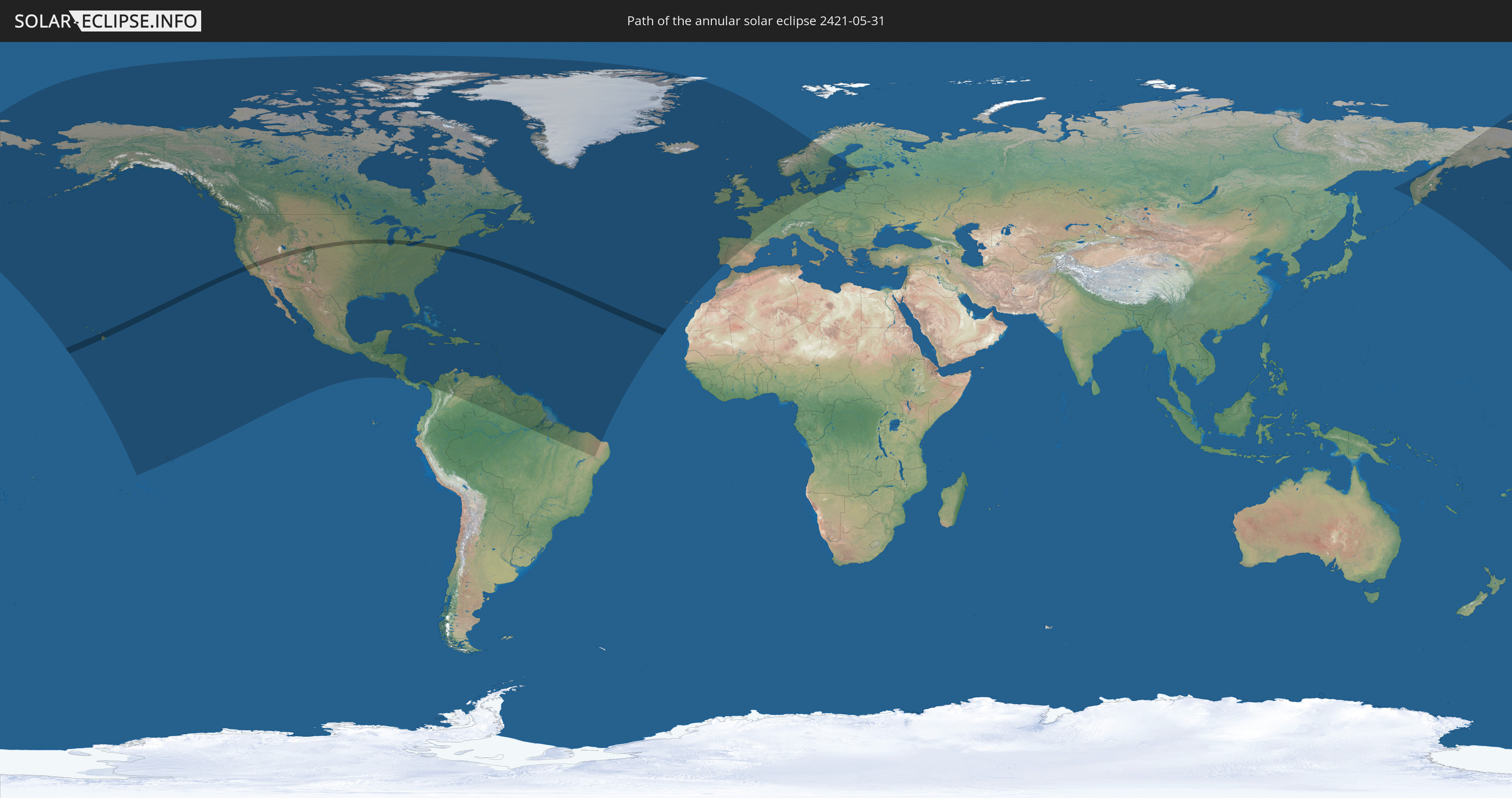
Die Sonnenfinsternis am 05/31/2421 kann man in 71 Ländern als partielle Sonnenfinsternis beobachten.
Der Finsternispfad verläuft durch 2 Länder. Nur in diesen Ländern ist sie als annular Sonnenfinsternis zu sehen.
In den folgenden Ländern ist die Sonnenfinsternis annular zu sehen
 United States
 Canada
In den folgenden Ländern ist die Sonnenfinsternis partiell zu sehen
 Russia
 United States
 United States Minor Outlying Islands
 French Polynesia
 Canada
 Mexico
 Greenland
 Guatemala
 El Salvador
 Honduras
 Belize
 Nicaragua
 Costa Rica
 Cuba
Cuba
 Panama
 Colombia
 Cayman Islands
 The Bahamas
 Jamaica
 Haiti
Haiti
 Brazil
 Venezuela
 Turks and Caicos Islands
 Dominican Republic
 Aruba
Aruba
 Puerto Rico
 United States Virgin Islands
 Bermuda
 British Virgin Islands
 Anguilla
 Collectivity of Saint Martin
 Saint Barthélemy
 Saint Kitts and Nevis
 Antigua and Barbuda
 Montserrat
 Trinidad and Tobago
 Guadeloupe
 Grenada
 Dominica
 Saint Vincent and the Grenadines
 Guyana
 Martinique
 Saint Lucia
 Barbados
 Suriname
 Saint Pierre and Miquelon
 French Guiana
 Portugal
 Cabo Verde
 Iceland
 Spain
Spain
 Republic of Ireland
 Svalbard and Jan Mayen
 United Kingdom
 Faroe Islands
 France
 Isle of Man
 Guernsey
 Jersey
 Belgium
 Netherlands
 Norway
 Luxembourg
 Germany
 Denmark
 Sweden
 Poland
 Åland Islands
 Finland
 Latvia
 Estonia
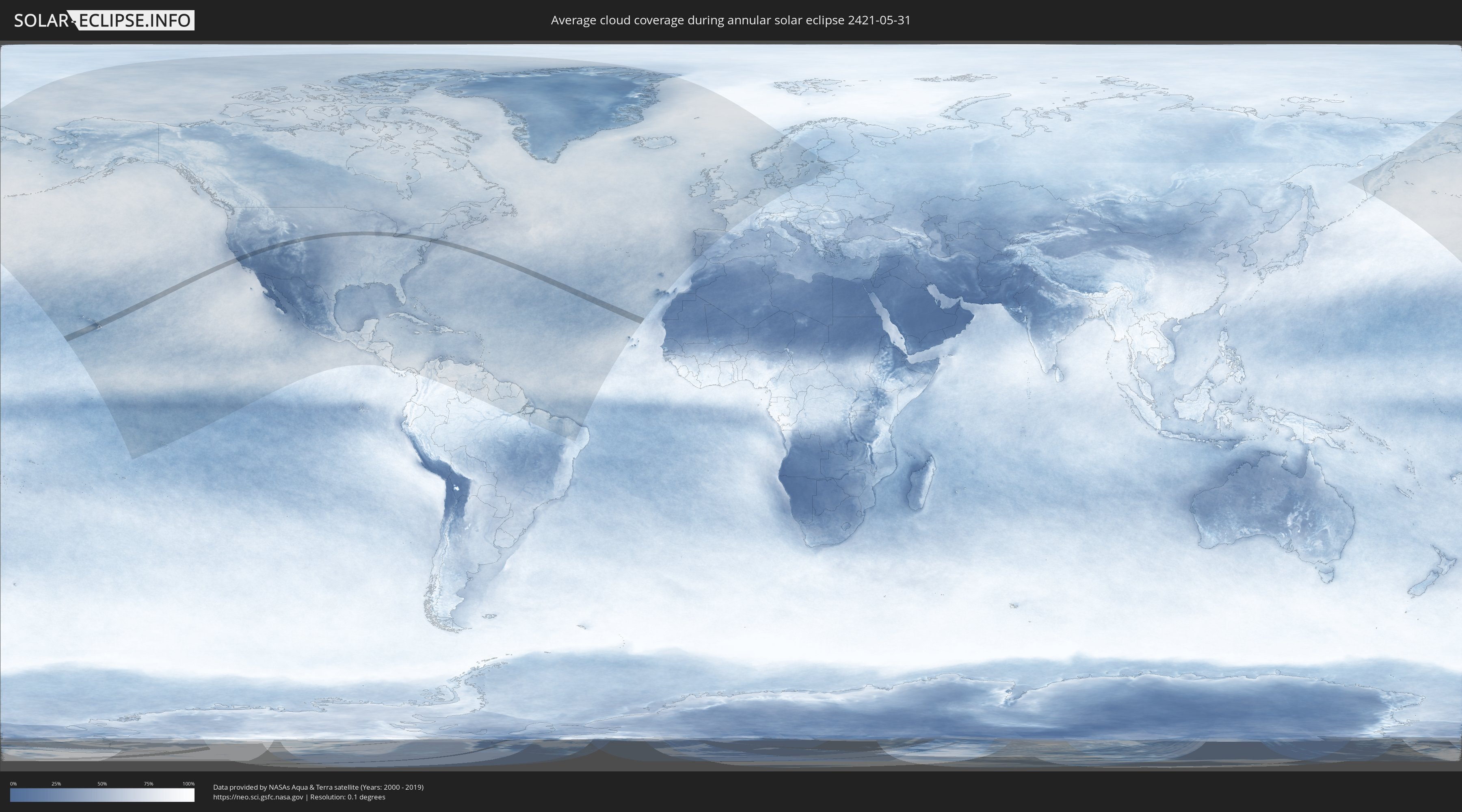
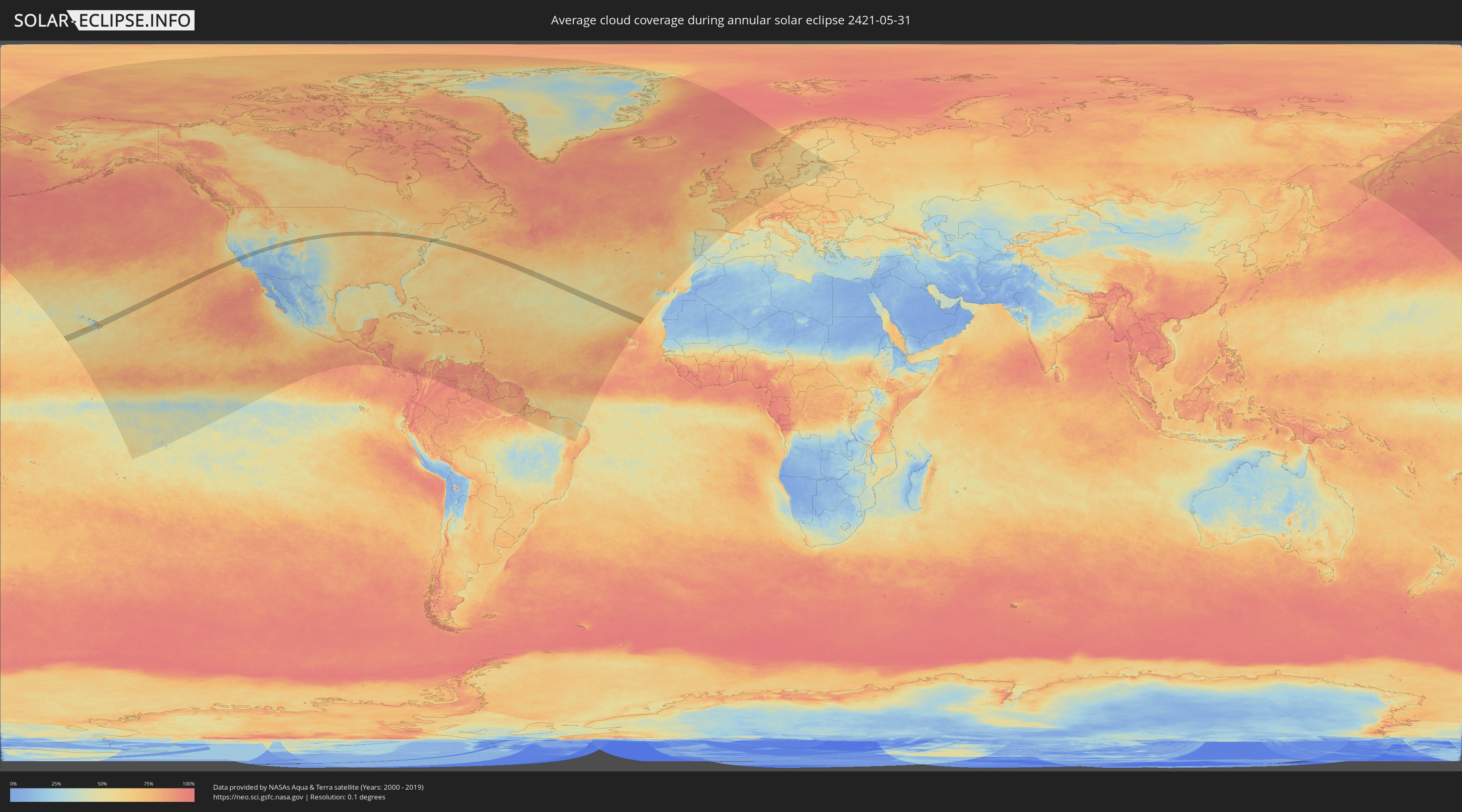
How will be the weather during the annular solar eclipse on 05/31/2421?
Where is the best place to see the annular solar eclipse of 05/31/2421?
The following maps show the average cloud coverage for the day of the annular solar eclipse.
With the help of these maps, it is possible to find the place along the eclipse path, which has the best
chance of a cloudless sky.
Nevertheless, you should consider local circumstances and inform about the weather of your chosen
observation site.
The data is provided by NASAs satellites
AQUA and TERRA.
The cloud maps are averaged over a period of 19 years (2000 - 2019).
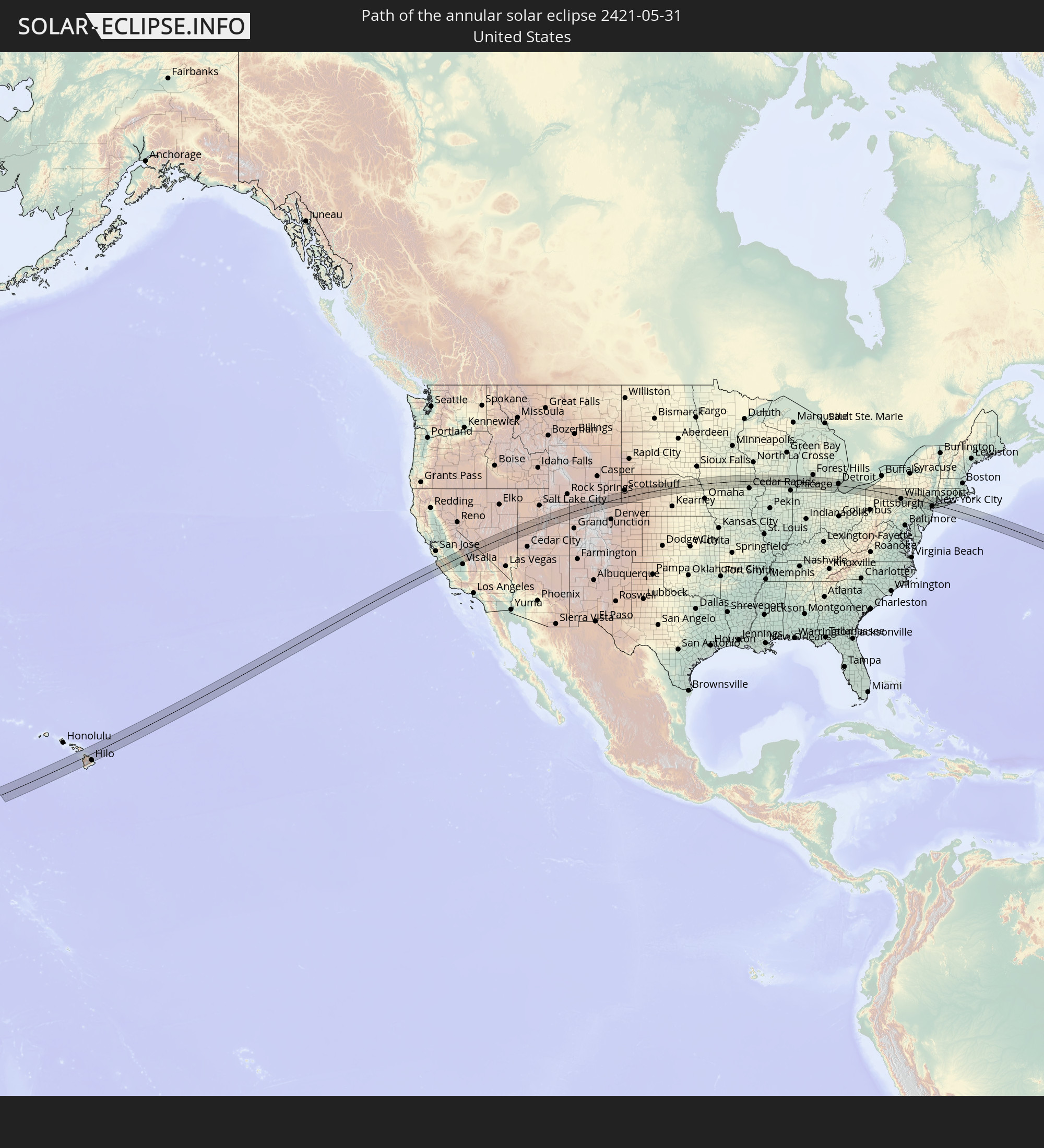
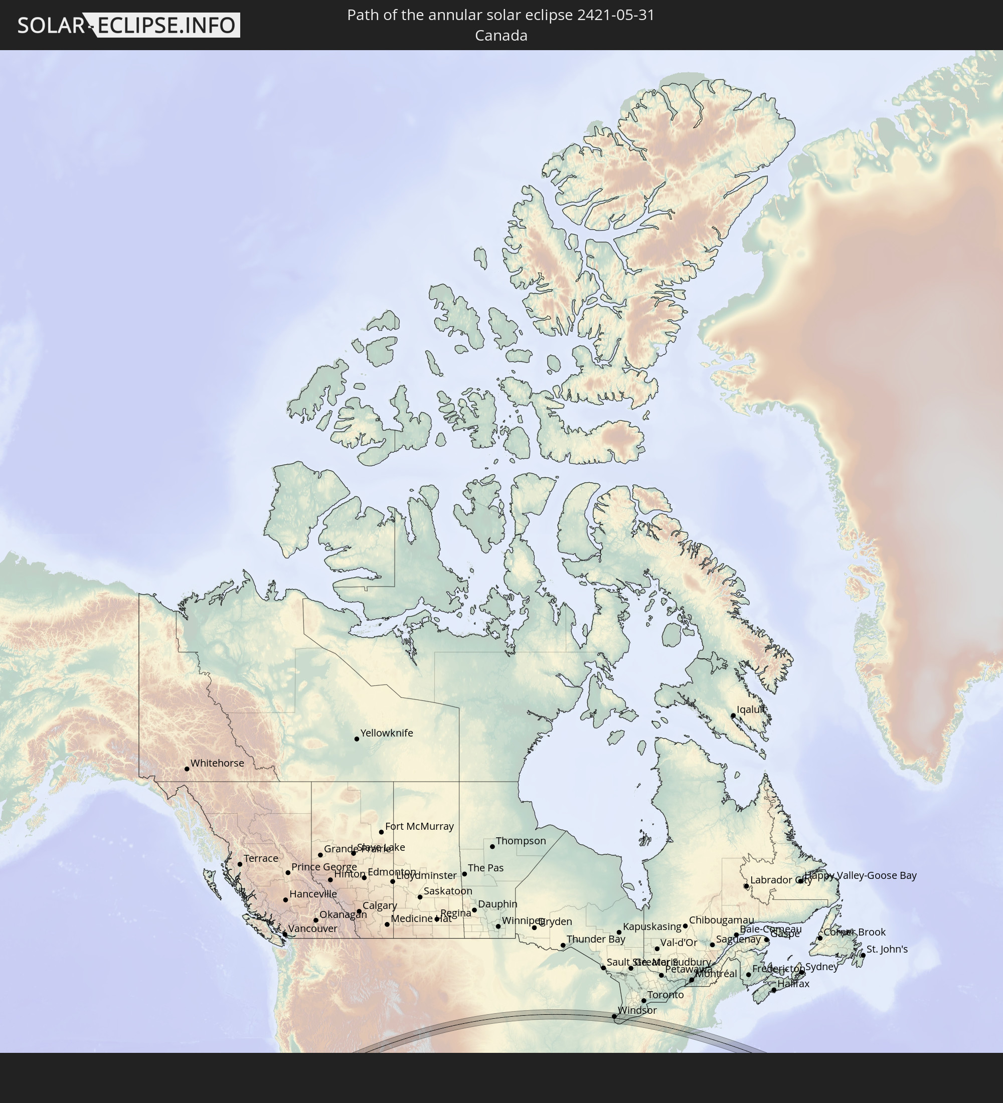
Detailed country maps
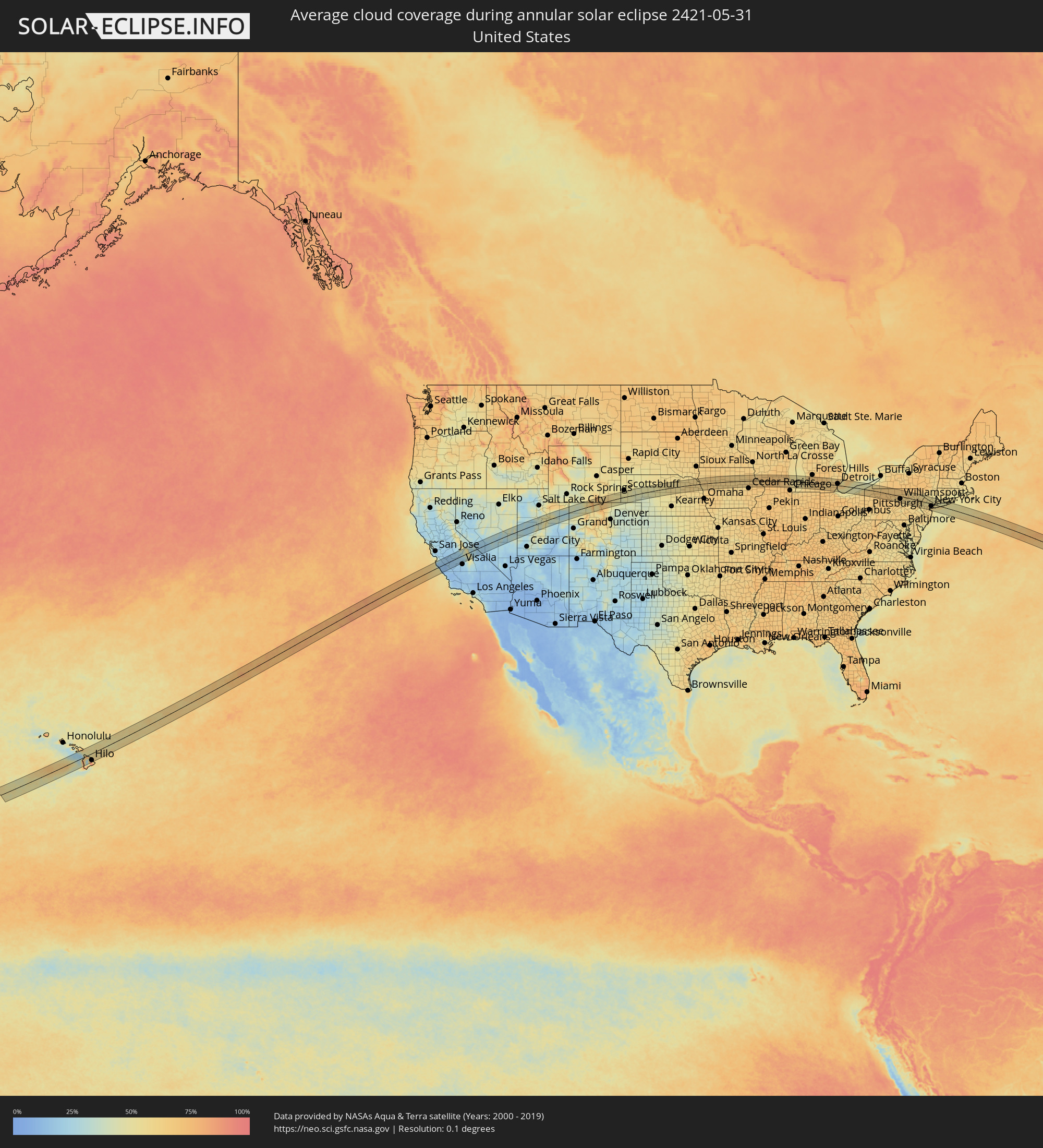 United States
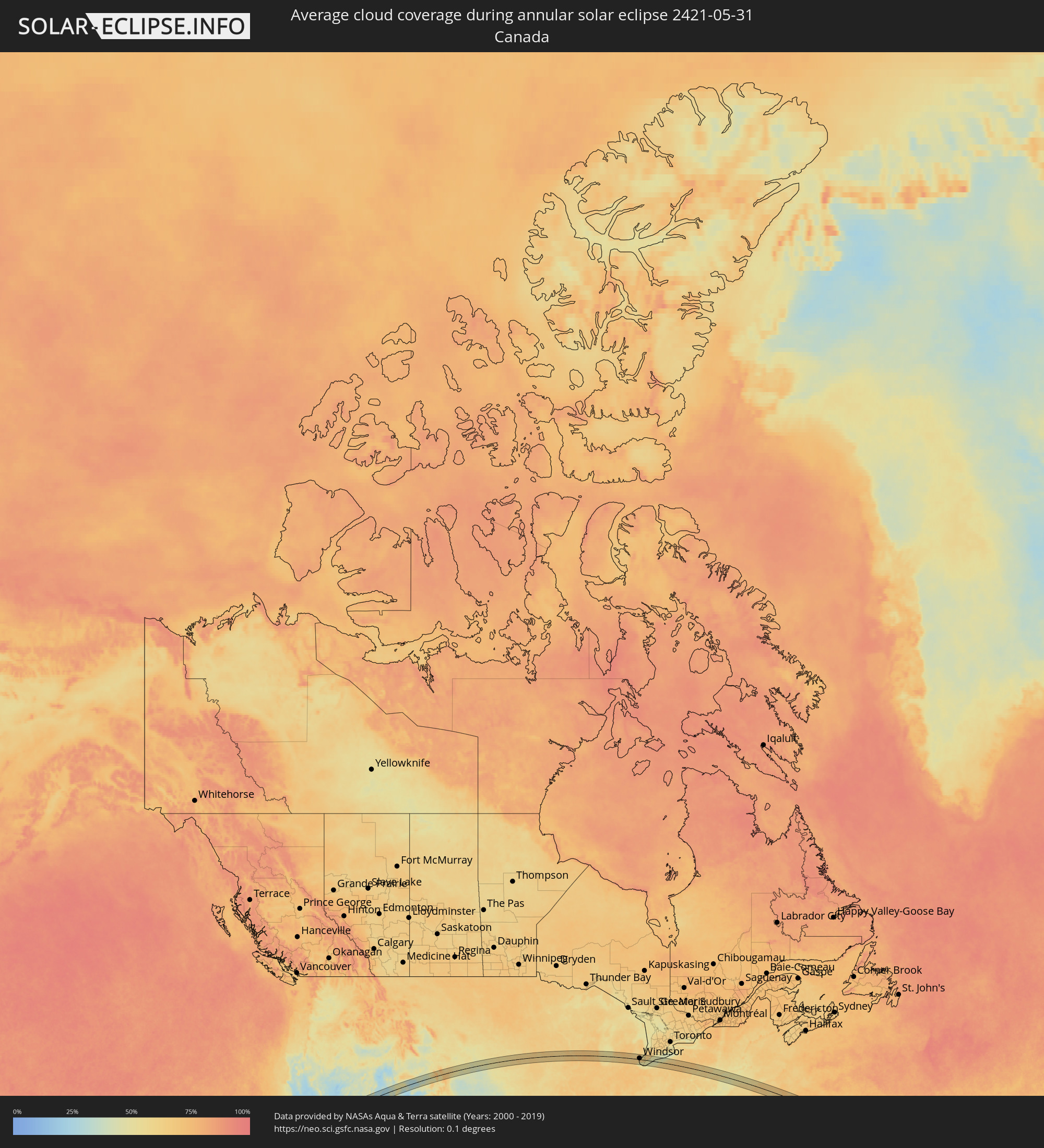 Canada
Cities inside the path of the eclipse
The following table shows all locations with a population of more than 5,000 inside the eclipse path. Cities which have more than 100,000 inhabitants are marked bold. A click at the locations opens a detailed map.
| City | Type | Eclipse duration | Local time of max. eclipse | Distance to central line | Ø Cloud coverage |
|
Kailua-Kona, Hawaii
|
annular | - | 06:27:47 UTC-10:00 | 30 km | 68% |
|
Hilo, Hawaii
|
annular | - | 06:27:47 UTC-10:00 | 62 km | 81% |
|
Soledad, California
|
annular | - | 09:13:18 UTC-08:00 | 21 km | 15% |
|
King City, California
|
annular | - | 09:13:16 UTC-08:00 | 8 km | 12% |
|
Coalinga, California
|
annular | - | 09:14:19 UTC-08:00 | 46 km | 16% |
|
Chowchilla, California
|
annular | - | 09:16:02 UTC-08:00 | 49 km | 19% |
|
Madera, California
|
annular | - | 09:16:05 UTC-08:00 | 25 km | 19% |
|
Kerman, California
|
annular | - | 09:15:43 UTC-08:00 | 1 km | 18% |
|
Lemoore, California
|
annular | - | 09:15:29 UTC-08:00 | 52 km | 19% |
|
Fresno, California
|
annular | - | 09:16:12 UTC-08:00 | 7 km | 19% |
|
Sanger, California
|
annular | - | 09:16:29 UTC-08:00 | 20 km | 20% |
|
Reedley, California
|
annular | - | 09:16:29 UTC-08:00 | 35 km | 21% |
|
Steamboat Springs, Colorado
|
annular | - | 10:45:46 UTC-07:00 | 27 km | 56% |
|
Laramie, Wyoming
|
annular | - | 10:49:18 UTC-07:00 | 33 km | 57% |
|
Cheyenne, Wyoming
|
annular | - | 10:50:48 UTC-07:00 | 2 km | 56% |
|
Norfolk, Nebraska
|
annular | - | 12:08:15 UTC-06:00 | 21 km | 60% |
|
Sioux City, Iowa
|
annular | - | 12:10:48 UTC-06:00 | 21 km | 60% |
|
Fort Dodge, Iowa
|
annular | - | 12:15:59 UTC-06:00 | 5 km | 63% |
|
Boone, Iowa
|
annular | - | 12:16:35 UTC-06:00 | 45 km | 61% |
|
Waterloo, Iowa
|
annular | - | 12:20:14 UTC-06:00 | 3 km | 62% |
|
Dubuque, Iowa
|
annular | - | 12:24:08 UTC-06:00 | 6 km | 64% |
|
Freeport, Illinois
|
annular | - | 12:26:35 UTC-06:00 | 28 km | 71% |
|
Fitchburg, Wisconsin
|
annular | - | 12:26:49 UTC-06:00 | 46 km | 69% |
|
Stoughton, Wisconsin
|
annular | - | 12:27:24 UTC-06:00 | 41 km | 68% |
|
Rockford, Illinois
|
annular | - | 12:27:48 UTC-06:00 | 30 km | 70% |
|
Beloit, Wisconsin
|
annular | - | 12:27:54 UTC-06:00 | 4 km | 69% |
|
Janesville, Wisconsin
|
annular | - | 12:27:54 UTC-06:00 | 16 km | 69% |
|
Belvidere, Illinois
|
annular | - | 12:28:23 UTC-06:00 | 31 km | 67% |
|
Whitewater, Wisconsin
|
annular | - | 12:28:31 UTC-06:00 | 33 km | 67% |
|
Crystal Lake, Illinois
|
annular | - | 12:29:37 UTC-06:00 | 32 km | 66% |
|
Salem, Wisconsin
|
annular | - | 12:30:00 UTC-06:00 | 4 km | 65% |
|
Franklin, Wisconsin
|
annular | - | 12:30:04 UTC-06:00 | 41 km | 69% |
|
Lindenhurst, Illinois
|
annular | - | 12:30:14 UTC-06:00 | 12 km | 65% |
|
Mundelein, Illinois
|
annular | - | 12:30:20 UTC-06:00 | 29 km | 66% |
|
Arlington Heights, Illinois
|
annular | - | 12:30:26 UTC-06:00 | 48 km | 70% |
|
Waukegan, Illinois
|
annular | - | 12:30:40 UTC-06:00 | 17 km | 63% |
|
Kenosha, Wisconsin
|
annular | - | 12:30:39 UTC-06:00 | 8 km | 62% |
|
Highland Park, Illinois
|
annular | - | 12:30:49 UTC-06:00 | 37 km | 66% |
|
Racine, Wisconsin
|
annular | - | 12:30:42 UTC-06:00 | 24 km | 64% |
|
Holland, Michigan
|
annular | - | 13:34:26 UTC-05:00 | 38 km | 59% |
|
Cutlerville, Michigan
|
annular | - | 13:35:24 UTC-05:00 | 47 km | 68% |
|
Kalamazoo, Michigan
|
annular | - | 13:35:49 UTC-05:00 | 13 km | 62% |
|
Battle Creek, Michigan
|
annular | - | 13:36:44 UTC-05:00 | 8 km | 63% |
|
Lansing, Michigan
|
annular | - | 13:37:54 UTC-05:00 | 43 km | 67% |
|
Jackson, Michigan
|
annular | - | 13:38:30 UTC-05:00 | 9 km | 63% |
|
Adrian, Michigan
|
annular | - | 13:39:30 UTC-05:00 | 45 km | 67% |
|
Ann Arbor, Michigan
|
annular | - | 13:39:56 UTC-05:00 | 0 km | 63% |
|
Novi, Michigan
|
annular | - | 13:40:24 UTC-05:00 | 25 km | 64% |
|
Waterford, Michigan
|
annular | - | 13:40:24 UTC-05:00 | 49 km | 58% |
|
Monroe, Michigan
|
annular | - | 13:40:55 UTC-05:00 | 37 km | 60% |
|
Livonia, Michigan
|
annular | - | 13:40:44 UTC-05:00 | 14 km | 65% |
|
Taylor, Michigan
|
annular | - | 13:41:00 UTC-05:00 | 0 km | 65% |
|
Southfield, Michigan
|
annular | - | 13:40:57 UTC-05:00 | 26 km | 65% |
|
Troy, Michigan
|
annular | - | 13:41:02 UTC-05:00 | 42 km | 68% |
|
Amherstburg, Ontario
|
annular | - | 13:41:33 UTC-05:00 | 11 km | 57% |
|
Detroit, Michigan
|
annular | - | 13:41:26 UTC-05:00 | 12 km | 63% |
|
Warren, Michigan
|
annular | - | 13:41:22 UTC-05:00 | 29 km | 65% |
|
Windsor, Ontario
|
annular | - | 13:41:31 UTC-05:00 | 9 km | 63% |
|
Clinton, Michigan
|
annular | - | 13:41:32 UTC-05:00 | 42 km | 64% |
|
Mentor, Ohio
|
annular | - | 13:45:35 UTC-05:00 | 41 km | 55% |
|
Ashtabula, Ohio
|
annular | - | 13:46:36 UTC-05:00 | 13 km | 54% |
|
Conneaut, Ohio
|
annular | - | 13:47:02 UTC-05:00 | 0 km | 58% |
|
Meadville, Pennsylvania
|
annular | - | 13:48:08 UTC-05:00 | 28 km | 64% |
|
Erie, Pennsylvania
|
annular | - | 13:47:53 UTC-05:00 | 26 km | 56% |
|
Jamestown, New York
|
annular | - | 13:49:40 UTC-05:00 | 35 km | 62% |
|
Saint Marys, Pennsylvania
|
annular | - | 13:51:39 UTC-05:00 | 28 km | 68% |
|
Olean, New York
|
annular | - | 13:51:19 UTC-05:00 | 45 km | 65% |
|
Williamsport, Pennsylvania
|
annular | - | 13:54:59 UTC-05:00 | 21 km | 60% |
|
Bloomsburg, Pennsylvania
|
annular | - | 13:56:19 UTC-05:00 | 37 km | 58% |
|
Hazleton, Pennsylvania
|
annular | - | 13:57:19 UTC-05:00 | 32 km | 60% |
|
Wilkes-Barre, Pennsylvania
|
annular | - | 13:57:12 UTC-05:00 | 1 km | 59% |
|
Scranton, Pennsylvania
|
annular | - | 13:57:27 UTC-05:00 | 22 km | 59% |
|
Easton, Pennsylvania
|
annular | - | 13:59:05 UTC-05:00 | 47 km | 58% |
|
Hopatcong Hills, New Jersey
|
annular | - | 13:59:51 UTC-05:00 | 8 km | 57% |
|
Bridgewater, New Jersey
|
annular | - | 14:00:17 UTC-05:00 | 44 km | 60% |
|
Parsippany, New Jersey
|
annular | - | 14:00:25 UTC-05:00 | 12 km | 56% |
|
Middletown, New York
|
annular | - | 13:59:46 UTC-05:00 | 52 km | 54% |
|
Edison, New Jersey
|
annular | - | 14:00:49 UTC-05:00 | 48 km | 62% |
|
West Milford, New Jersey
|
annular | - | 14:00:13 UTC-05:00 | 19 km | 53% |
|
Westfield, New Jersey
|
annular | - | 14:00:47 UTC-05:00 | 31 km | 61% |
|
East Orange, New Jersey
|
annular | - | 14:00:56 UTC-05:00 | 17 km | 58% |
|
Paterson, New Jersey
|
annular | - | 14:00:50 UTC-05:00 | 0 km | 59% |
|
Kiryas Joel, New York
|
annular | - | 14:00:21 UTC-05:00 | 46 km | 51% |
|
Ramsey, New Jersey
|
annular | - | 14:00:44 UTC-05:00 | 16 km | 55% |
|
Staten Island, New York
|
annular | - | 14:01:17 UTC-05:00 | 37 km | 59% |
|
New York City, New York
|
annular | - | 14:01:22 UTC-05:00 | 18 km | 61% |
|
New City, New York
|
annular | - | 14:00:54 UTC-05:00 | 29 km | 53% |
|
Peekskill, New York
|
annular | - | 14:00:52 UTC-05:00 | 46 km | 51% |
|
The Bronx, New York
|
annular | - | 14:01:29 UTC-05:00 | 1 km | 59% |
|
Greenburgh, New York
|
annular | - | 14:01:19 UTC-05:00 | 20 km | 54% |
|
Jamaica, New York
|
annular | - | 14:01:46 UTC-05:00 | 16 km | 57% |
|
Glen Cove, New York
|
annular | - | 14:01:54 UTC-05:00 | 6 km | 49% |
|
Hempstead, New York
|
annular | - | 14:02:06 UTC-05:00 | 10 km | 56% |
|
Stamford, Connecticut
|
annular | - | 14:01:51 UTC-05:00 | 29 km | 55% |
|
Wilton, Connecticut
|
annular | - | 14:01:52 UTC-05:00 | 46 km | 54% |
|
Huntington Station, New York
|
annular | - | 14:02:19 UTC-05:00 | 10 km | 48% |
|
Lindenhurst, New York
|
annular | - | 14:02:35 UTC-05:00 | 7 km | 58% |
|
Brentwood, New York
|
annular | - | 14:02:42 UTC-05:00 | 6 km | 56% |
|
Bridgeport, Connecticut
|
annular | - | 14:02:20 UTC-05:00 | 48 km | 55% |
|
Coram, New York
|
annular | - | 14:03:03 UTC-05:00 | 21 km | 50% |
|
Mastic, New York
|
annular | - | 14:03:25 UTC-05:00 | 17 km | 58% |
|
Hampton Bays, New York
|
annular | - | 14:03:56 UTC-05:00 | 32 km | 57% |