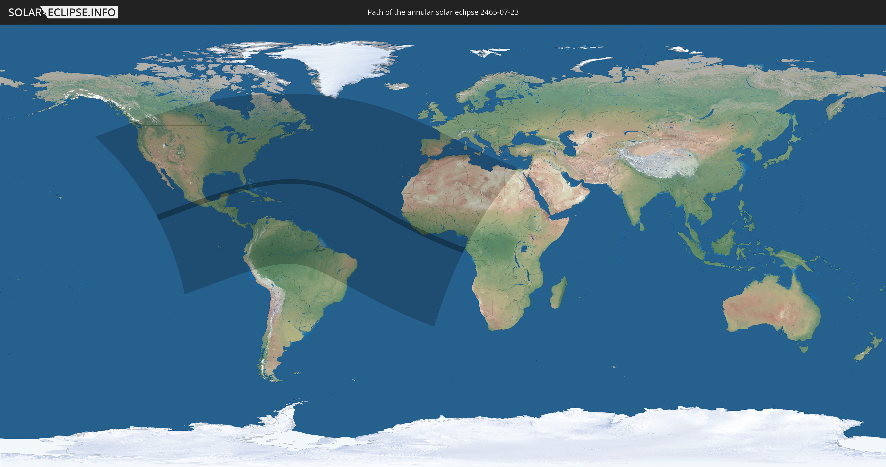
Annular solar eclipse of 07/23/2465
| Day of week: | Thursday |
| Maximum duration of eclipse: | 06m35s |
| Maximum width of eclipse path: | 191 km |
| Saros cycle: | 153 |
| Coverage: | 94.8% |
| Magnitude: | 0.9482 |
| Gamma: | 0.0904 |
Wo kann man die Sonnenfinsternis vom 07/23/2465 sehen?
Die Sonnenfinsternis am 07/23/2465 kann man in 81 Ländern als partielle Sonnenfinsternis beobachten.
Der Finsternispfad verläuft durch 10 Länder. Nur in diesen Ländern ist sie als annular Sonnenfinsternis zu sehen.
In den folgenden Ländern ist die Sonnenfinsternis annular zu sehen
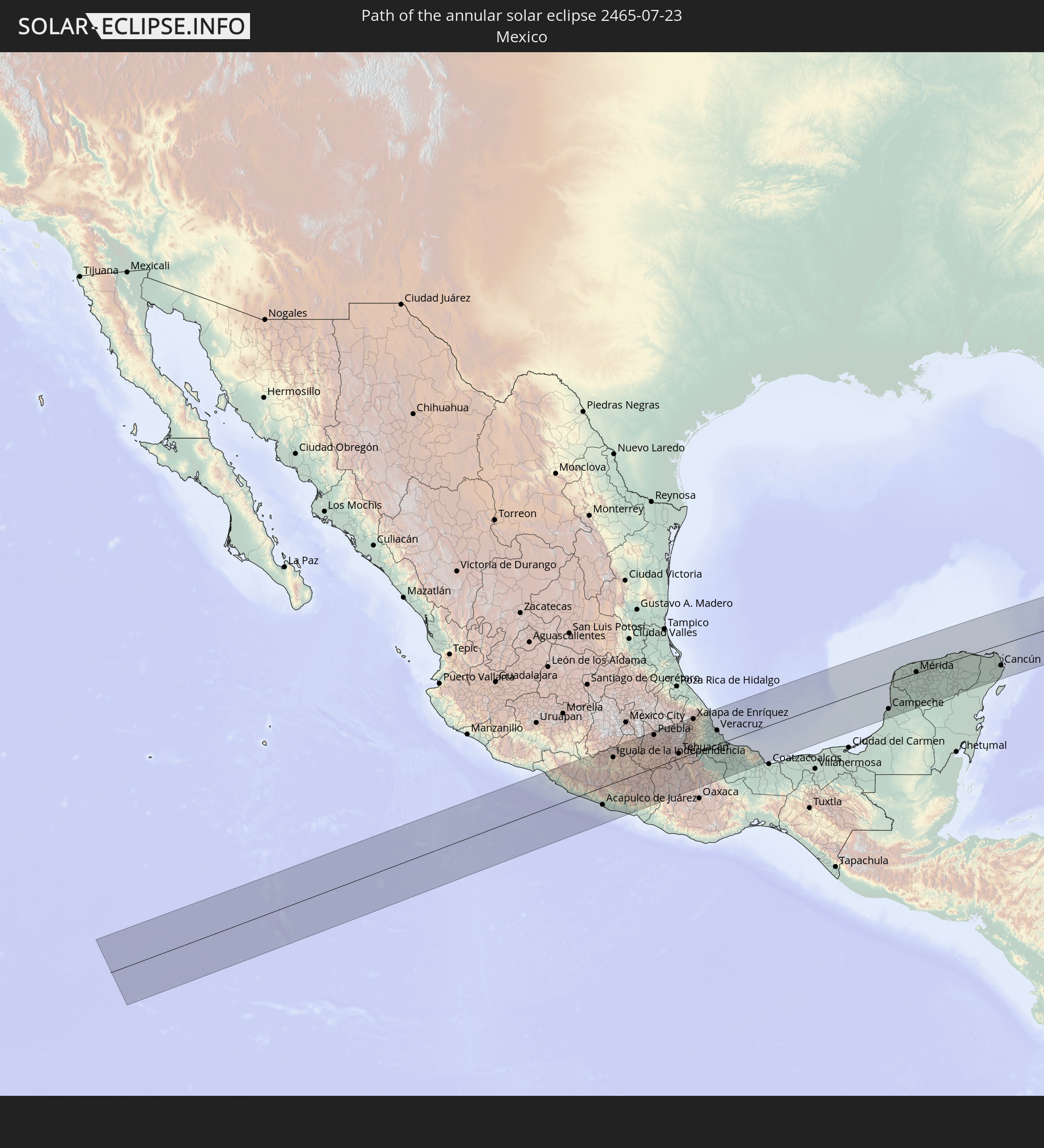 Mexico
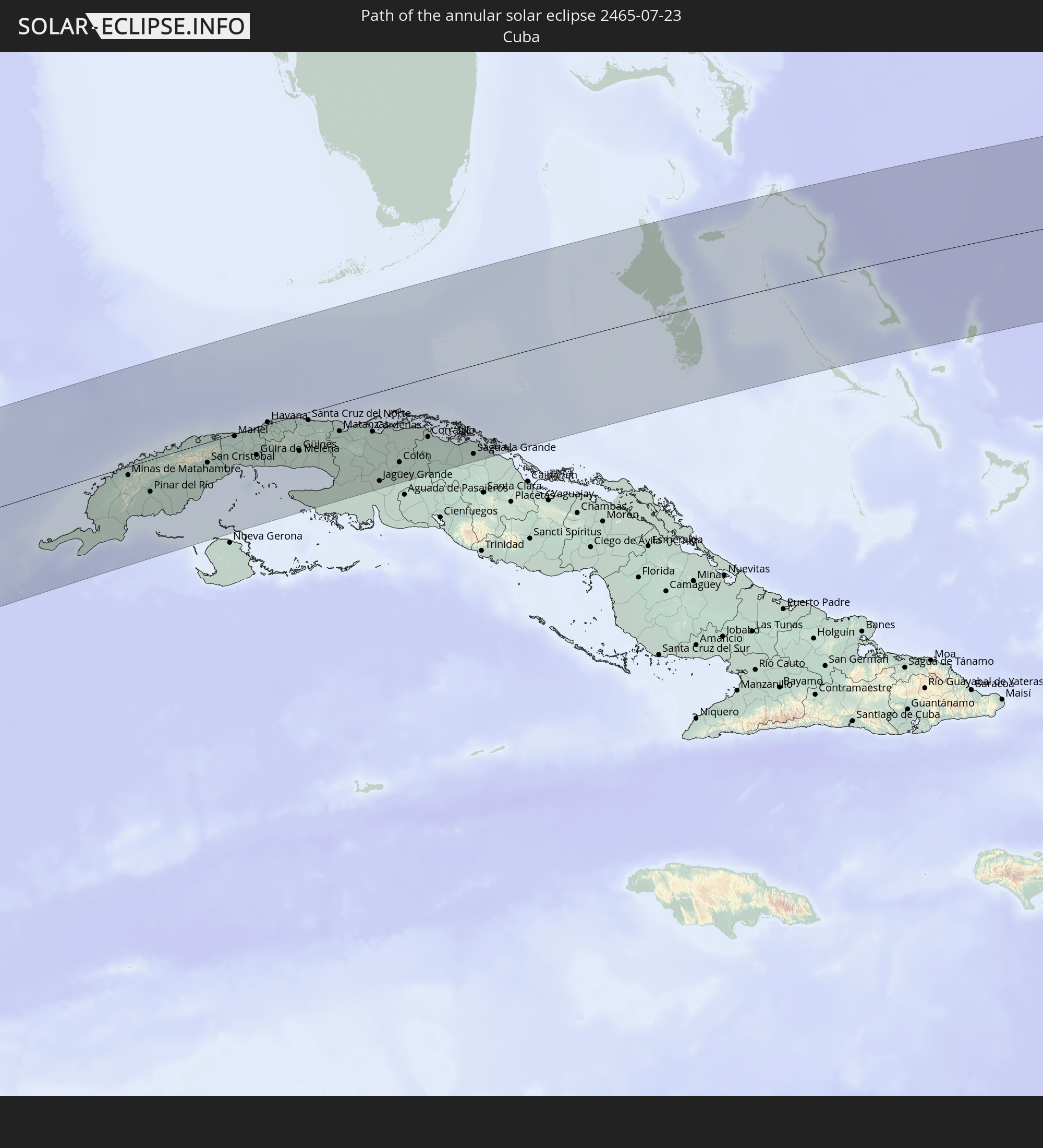 Cuba
Cuba
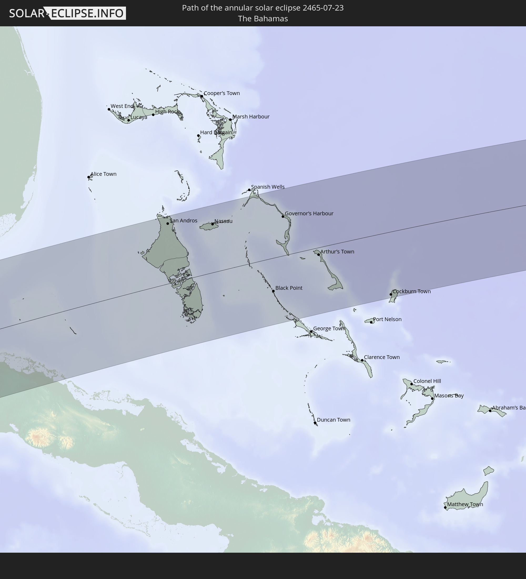 The Bahamas
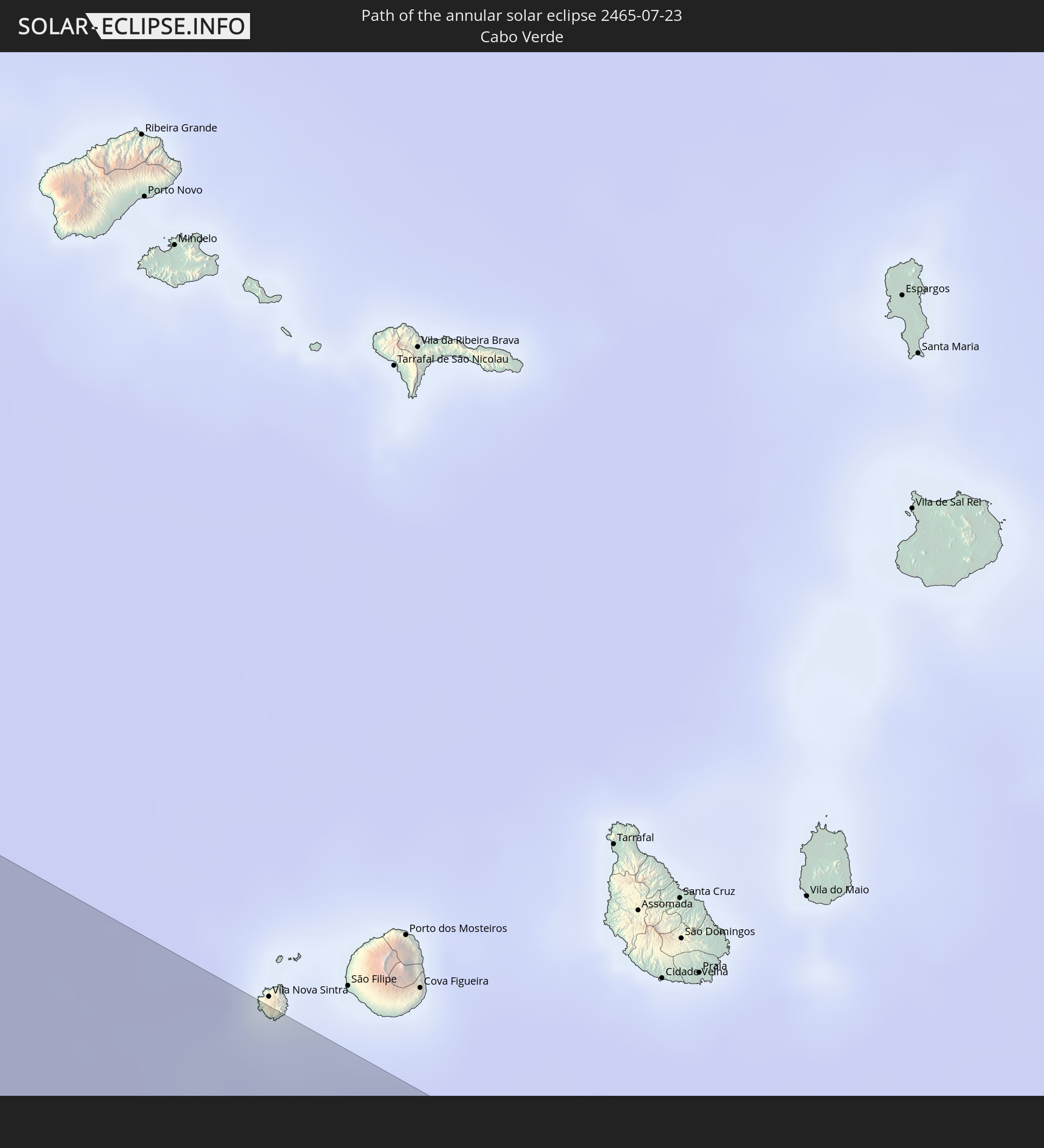 Cabo Verde
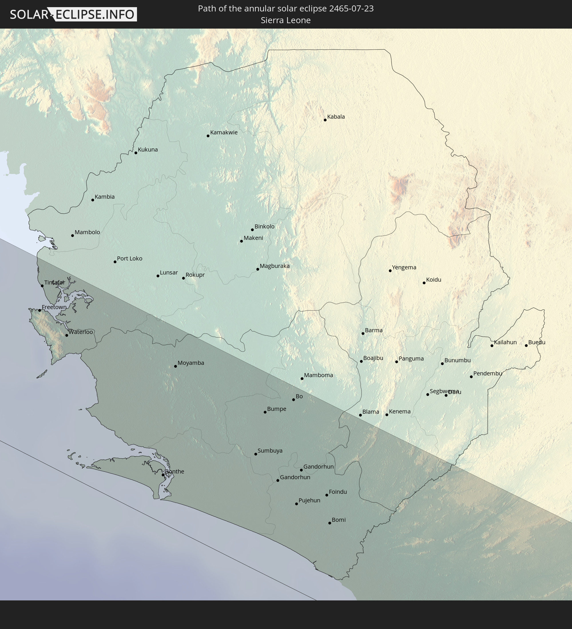 Sierra Leone
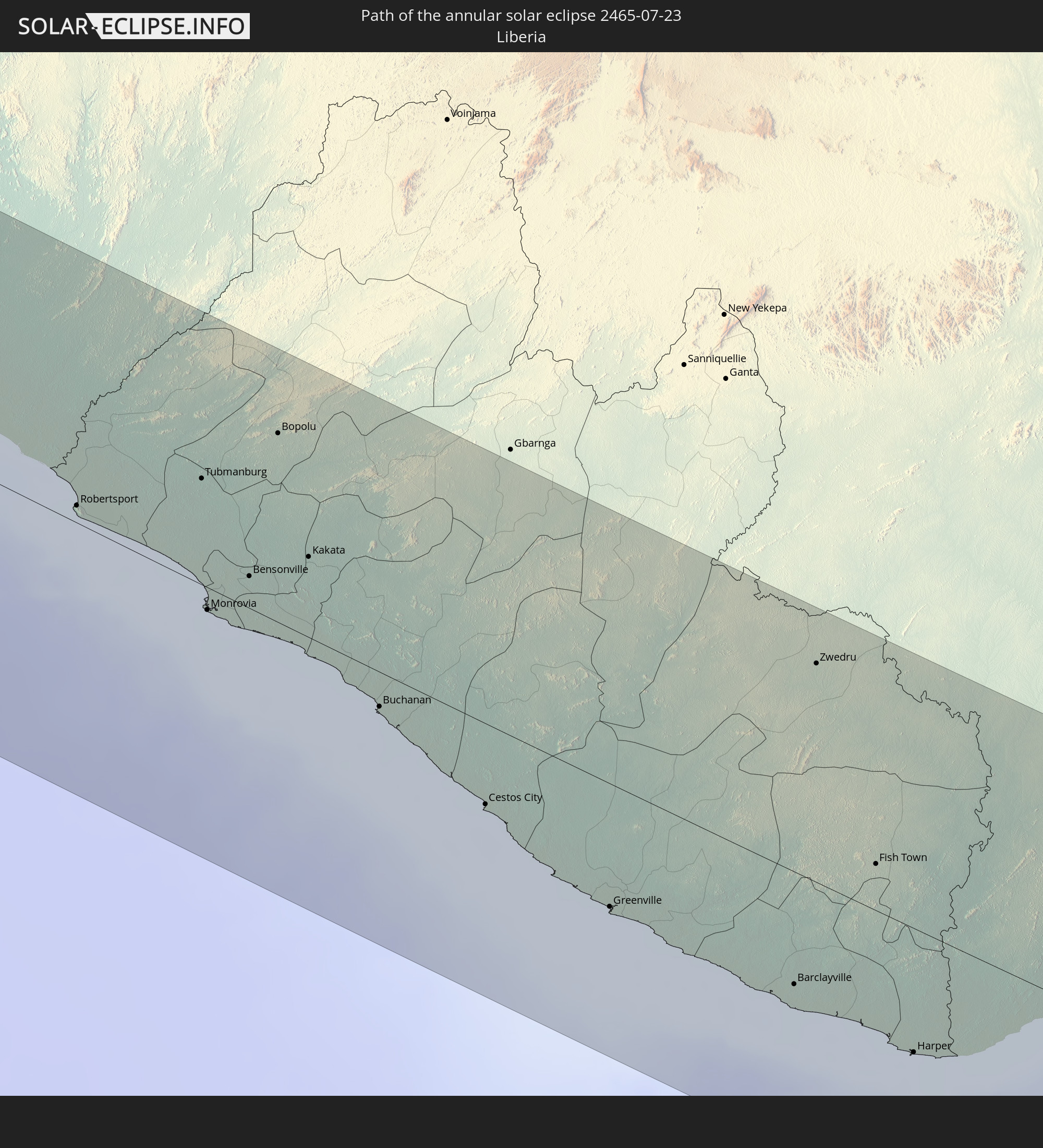 Liberia
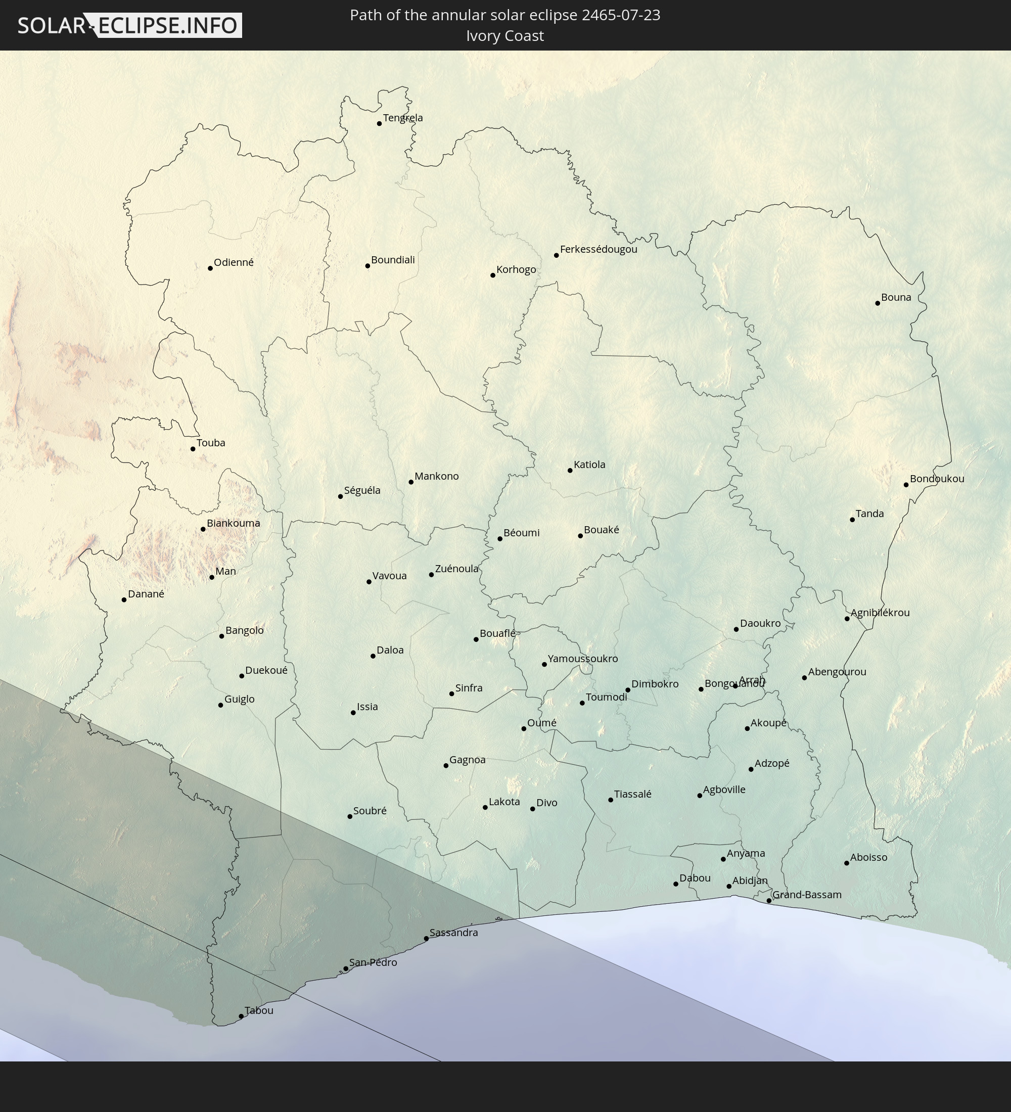 Ivory Coast
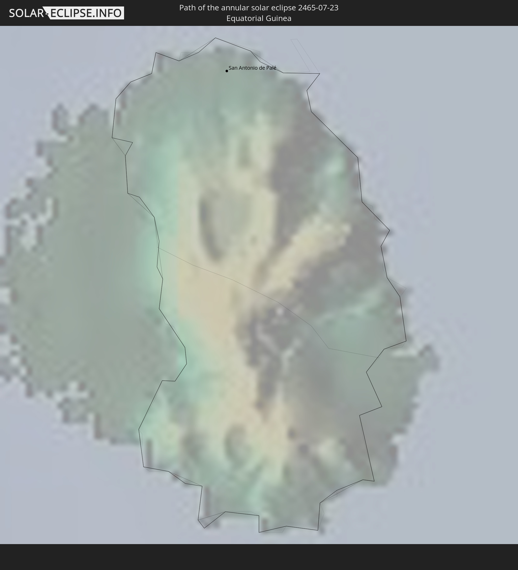 Equatorial Guinea
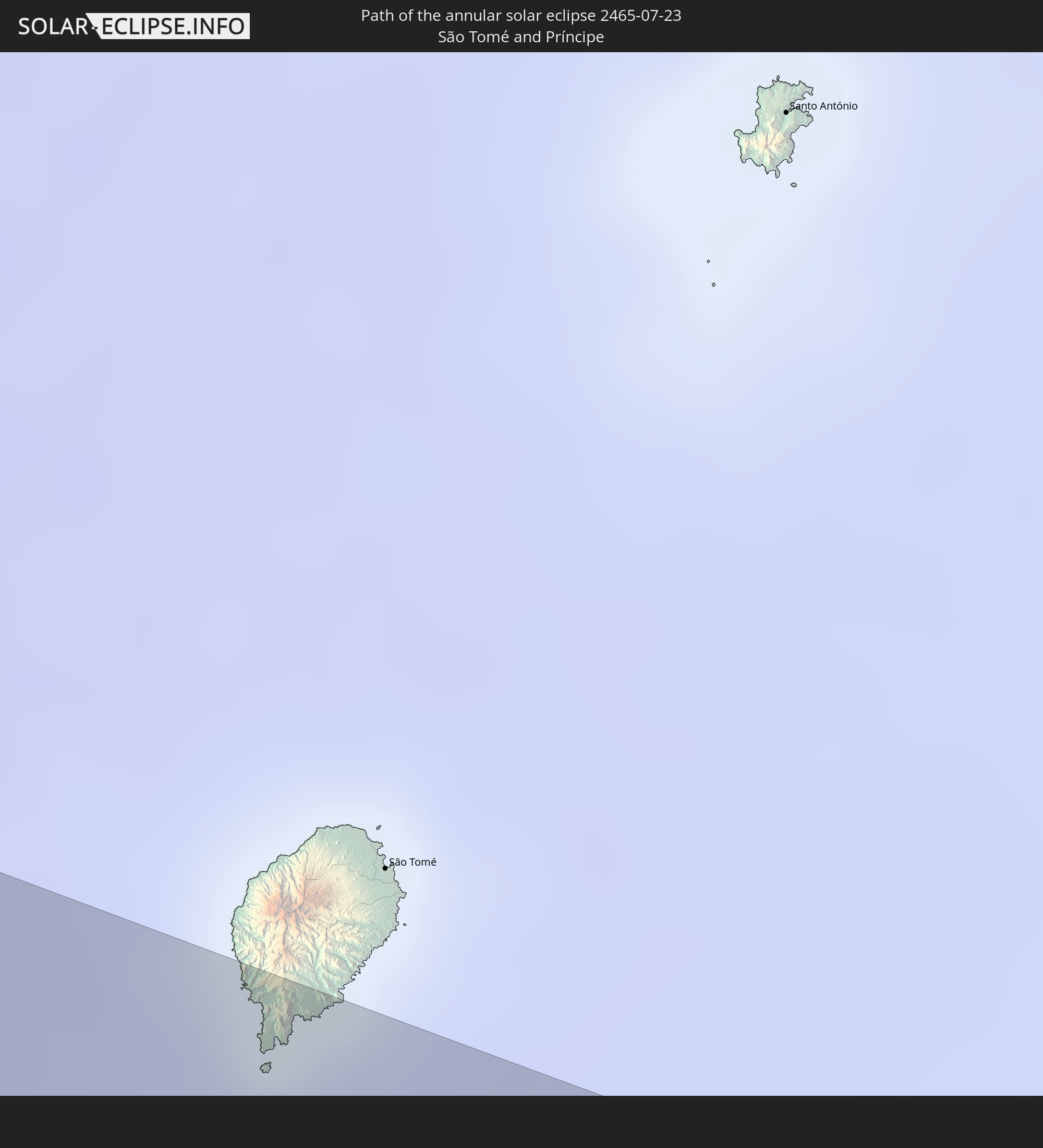 São Tomé and Príncipe
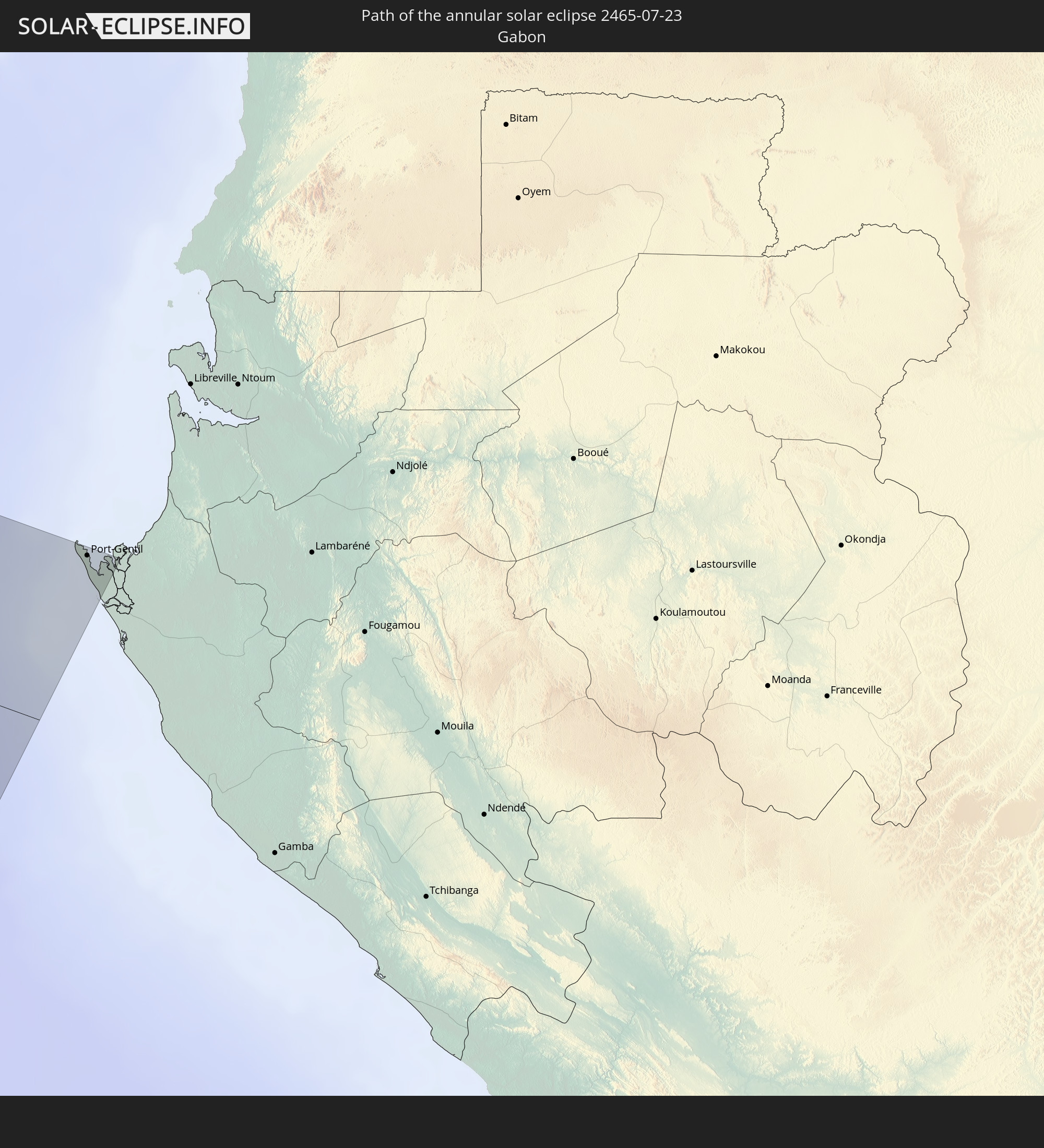 Gabon
Gabon
In den folgenden Ländern ist die Sonnenfinsternis partiell zu sehen
 United States
 United States Minor Outlying Islands
 Canada
 Mexico
 Greenland
 Guatemala
 Ecuador
 El Salvador
 Honduras
 Belize
 Nicaragua
 Costa Rica
 Cuba
Cuba
 Panama
 Colombia
 Cayman Islands
 Peru
Peru
 The Bahamas
 Jamaica
 Haiti
Haiti
 Brazil
 Venezuela
 Turks and Caicos Islands
 Dominican Republic
 Aruba
Aruba
 Puerto Rico
 United States Virgin Islands
 Bermuda
 British Virgin Islands
 Anguilla
 Collectivity of Saint Martin
 Saint Barthélemy
 Saint Kitts and Nevis
 Antigua and Barbuda
 Montserrat
 Trinidad and Tobago
 Guadeloupe
 Grenada
 Dominica
 Saint Vincent and the Grenadines
 Guyana
 Martinique
 Saint Lucia
 Barbados
 Suriname
 Saint Pierre and Miquelon
 French Guiana
 Portugal
 Cabo Verde
 Spain
Spain
 Senegal
 Mauritania
 The Gambia
 Guinea-Bissau
 Guinea
 Saint Helena, Ascension and Tristan da Cunha
 Sierra Leone
 Morocco
 Mali
Mali
 Liberia
 Algeria
 Ivory Coast
 Burkina Faso
 Gibraltar
 France
 Ghana
Ghana
 Togo
Togo
 Niger
Niger
 Benin
Benin
 Andorra
 Nigeria
 Equatorial Guinea
 São Tomé and Príncipe
 Italy
Italy
 Tunisia
 Cameroon
 Gabon
Gabon
 Libya
Libya
 Chad
Chad
 Malta
Malta
 Egypt
Egypt
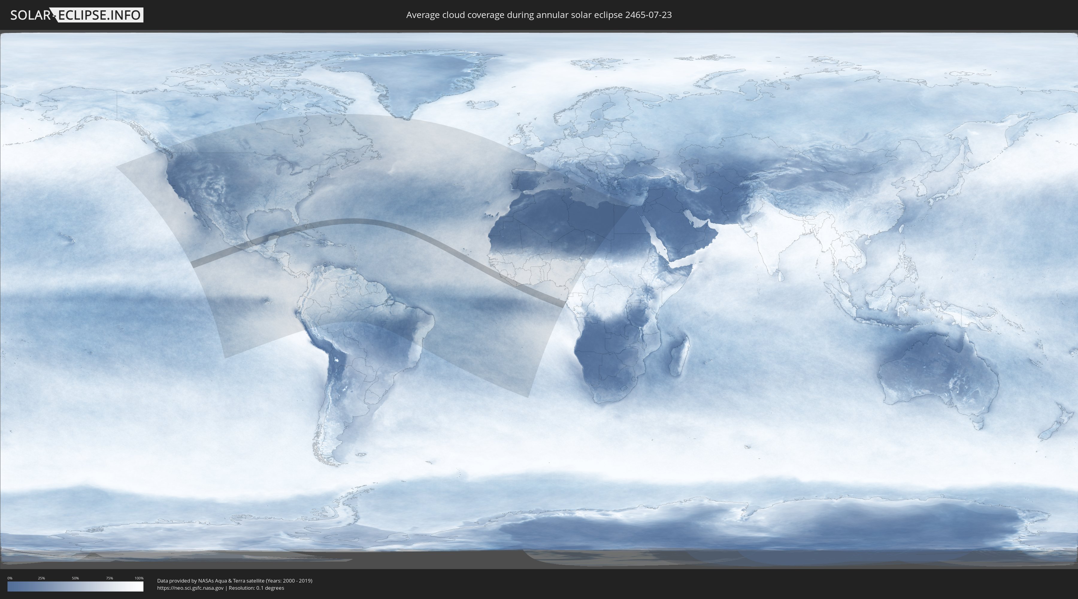
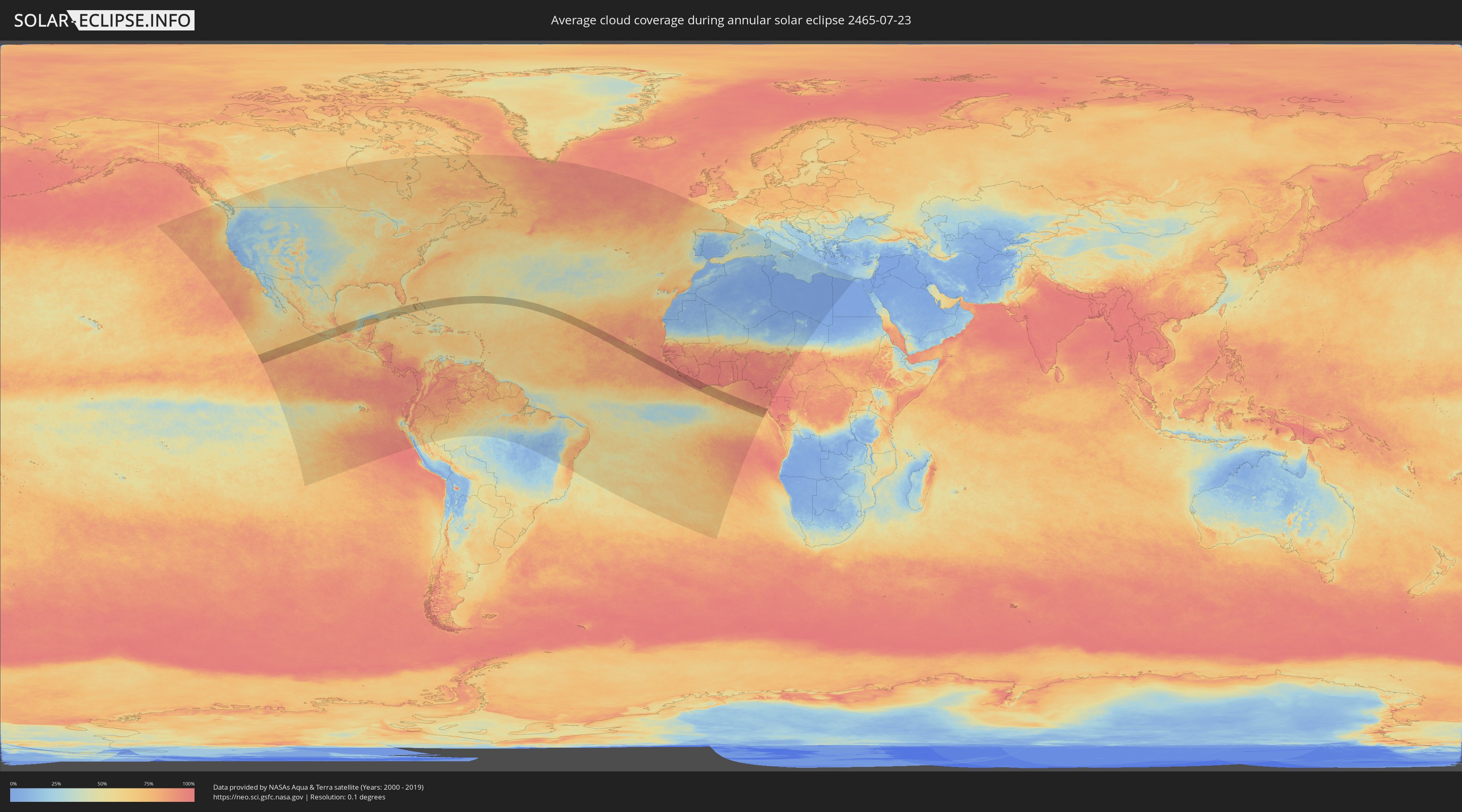
How will be the weather during the annular solar eclipse on 07/23/2465?
Where is the best place to see the annular solar eclipse of 07/23/2465?
The following maps show the average cloud coverage for the day of the annular solar eclipse.
With the help of these maps, it is possible to find the place along the eclipse path, which has the best
chance of a cloudless sky.
Nevertheless, you should consider local circumstances and inform about the weather of your chosen
observation site.
The data is provided by NASAs satellites
AQUA and TERRA.
The cloud maps are averaged over a period of 19 years (2000 - 2019).
Detailed country maps
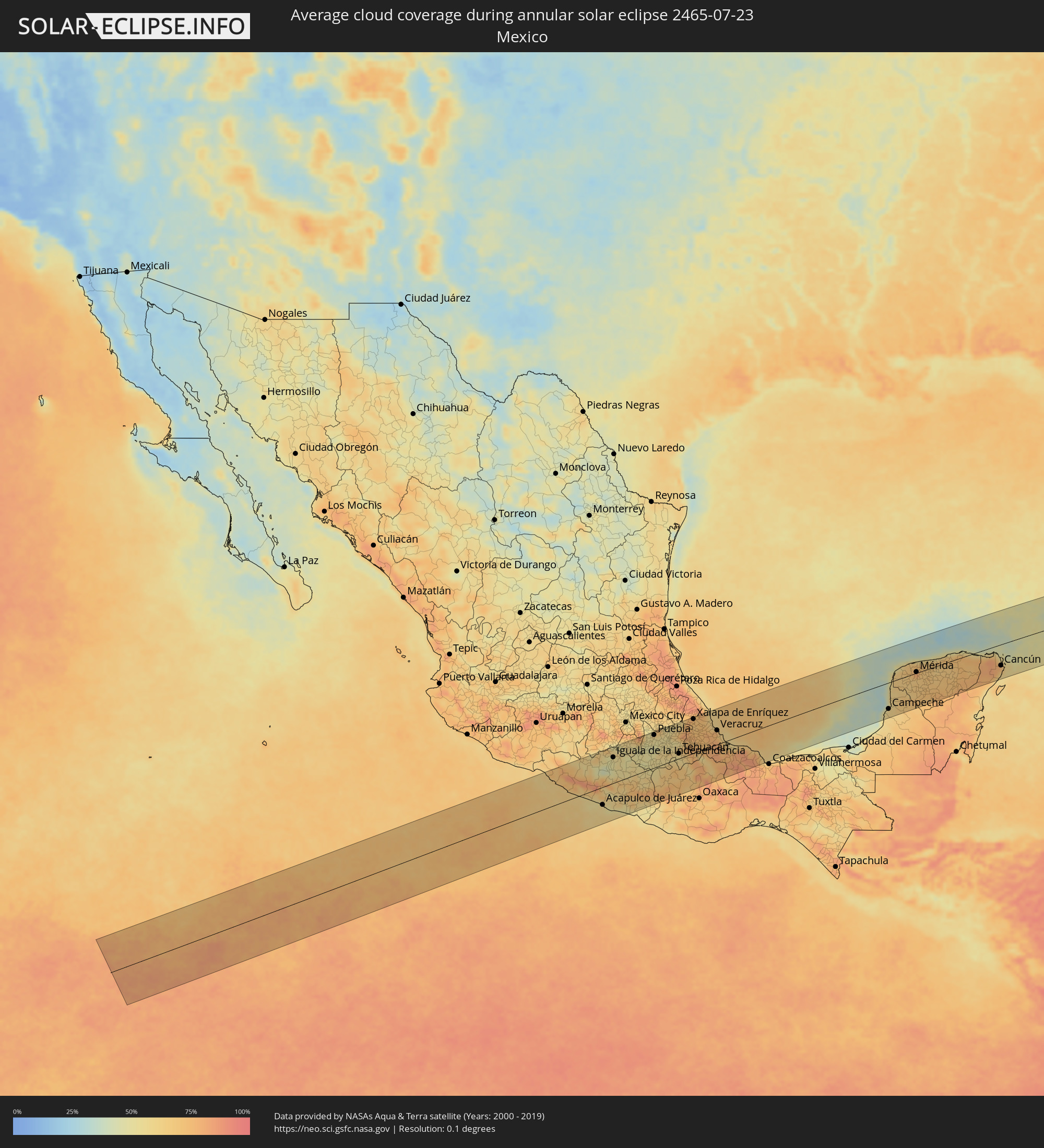 Mexico
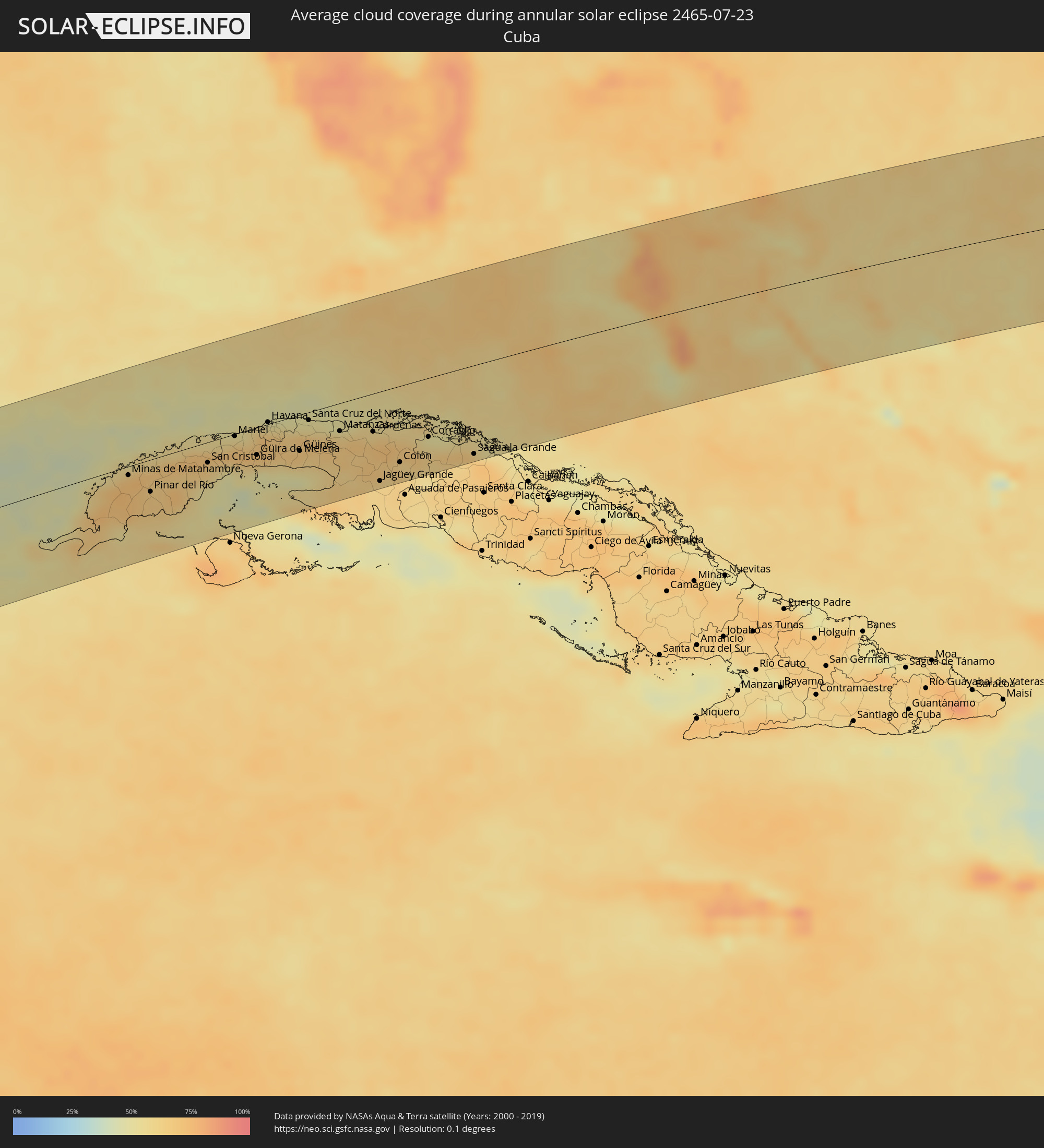 Cuba
Cuba
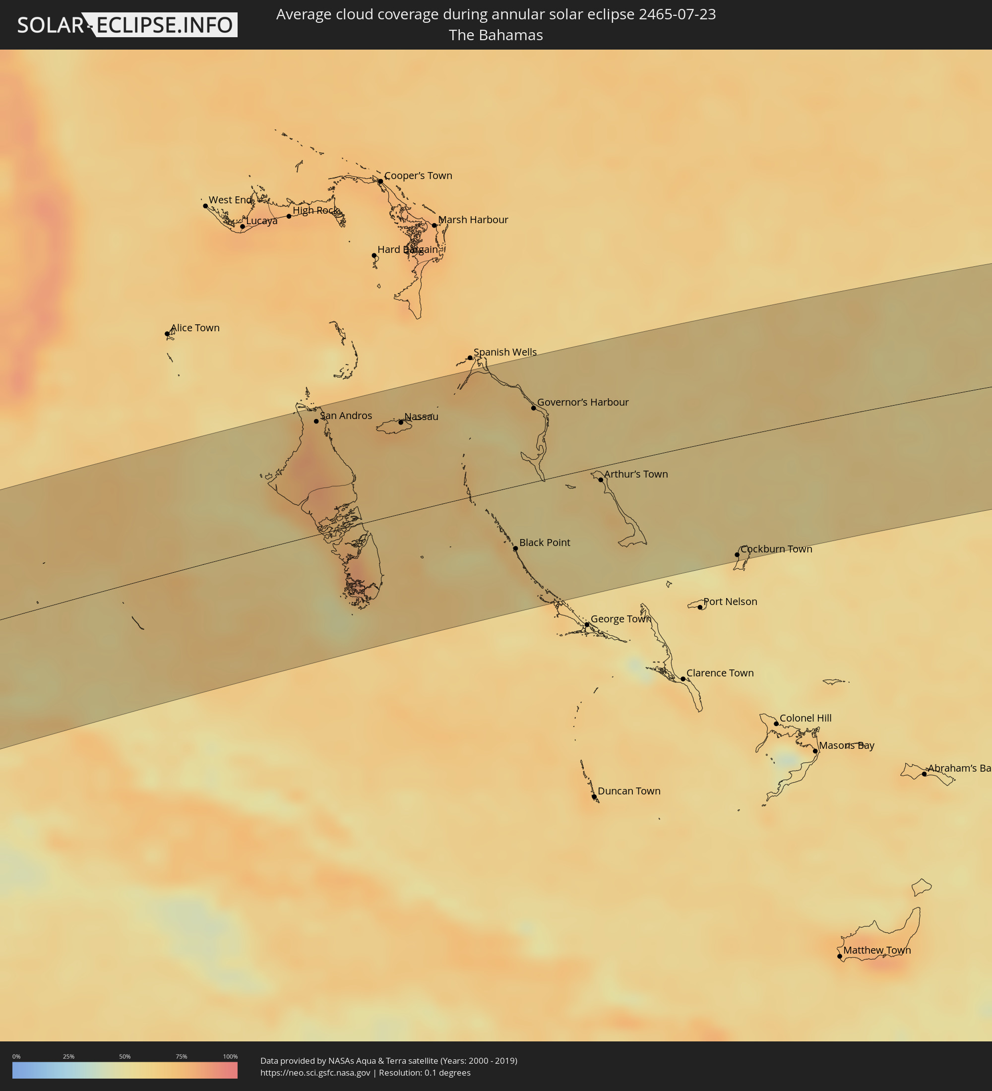 The Bahamas
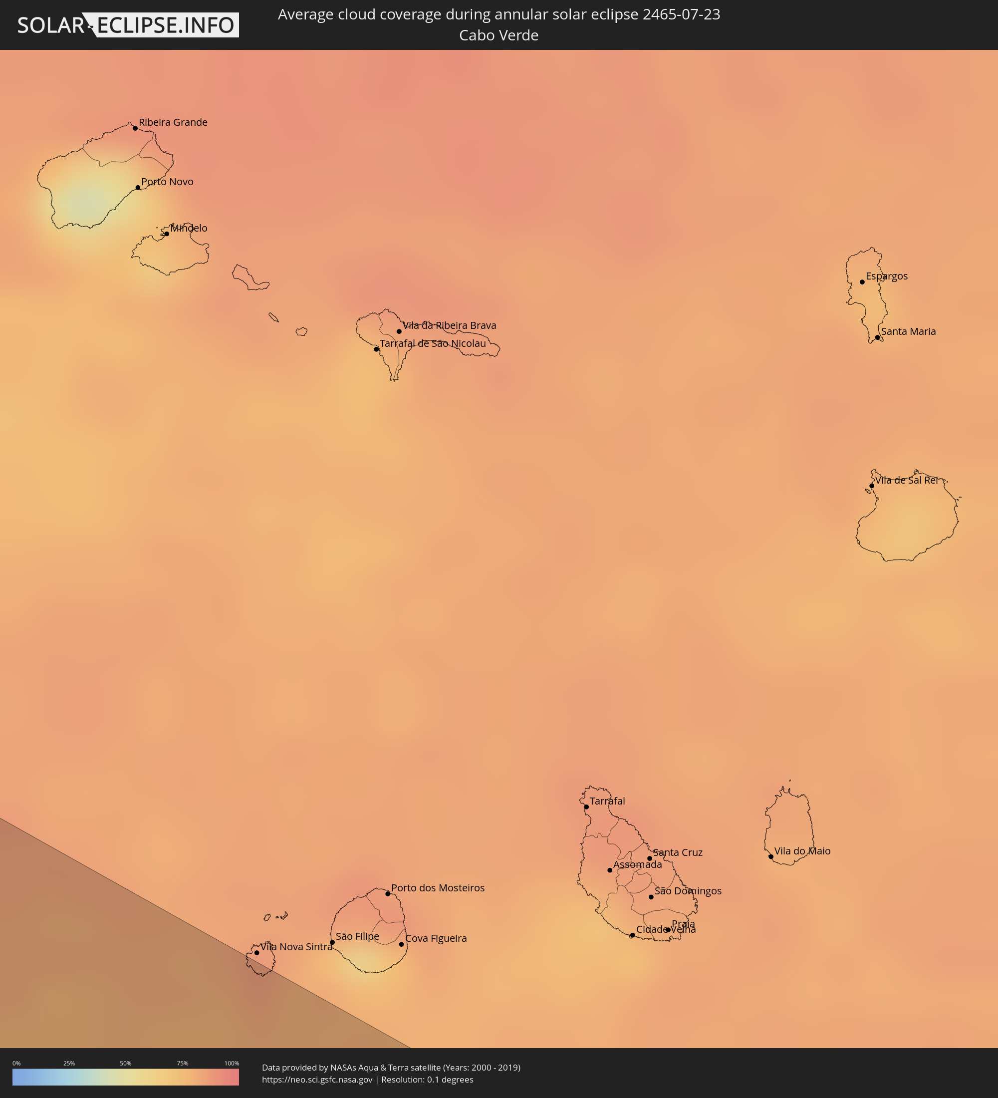 Cabo Verde
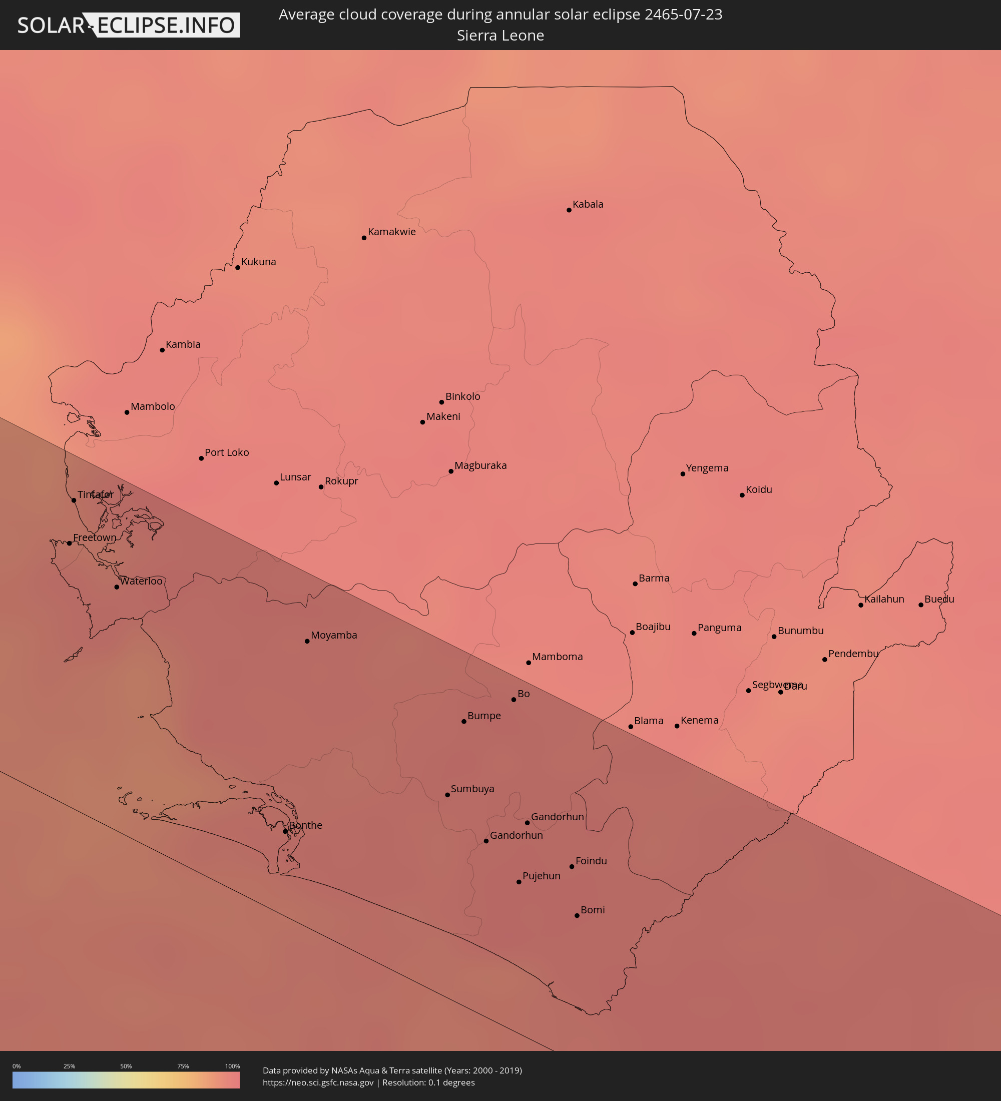 Sierra Leone
 Liberia
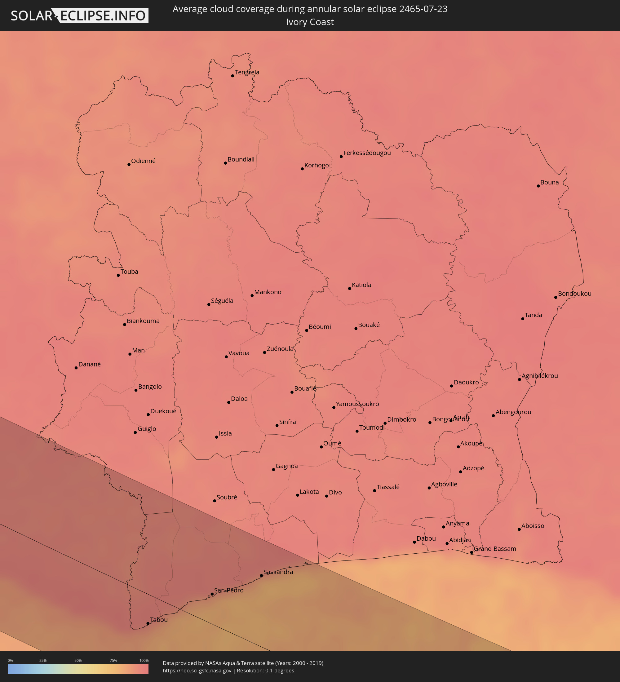 Ivory Coast
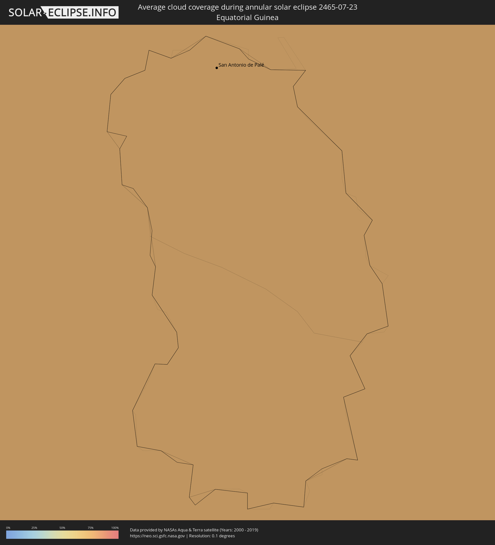 Equatorial Guinea
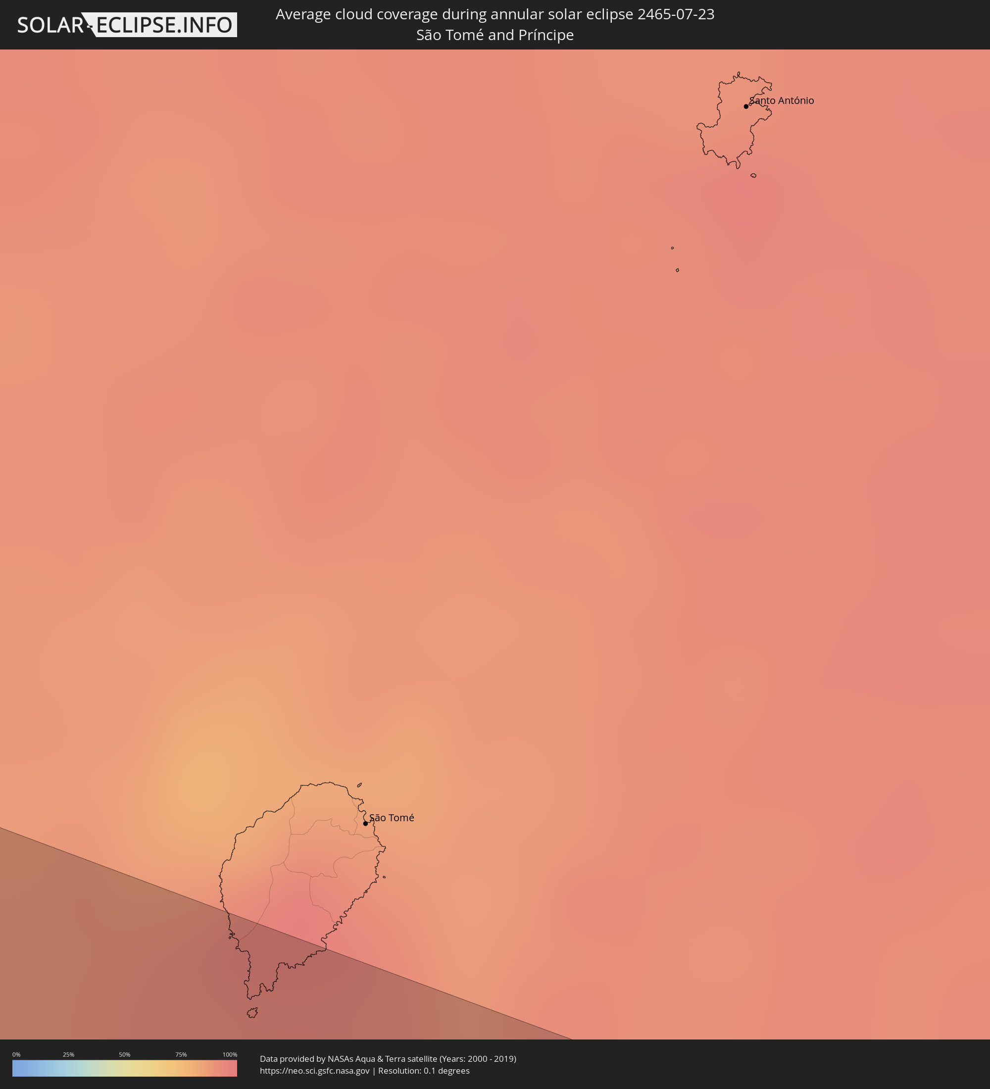 São Tomé and Príncipe
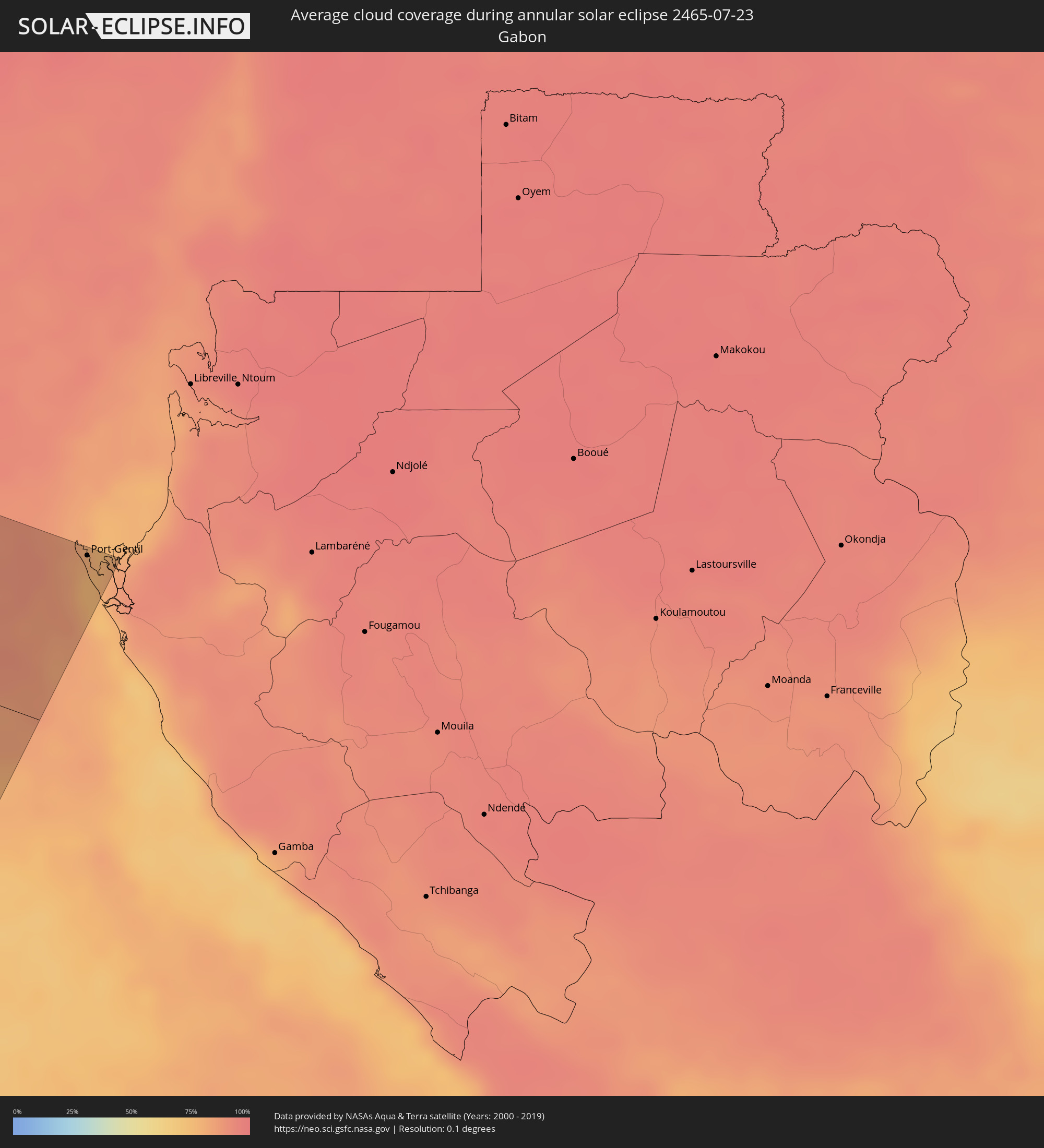 Gabon
Gabon
Cities inside the path of the eclipse
The following table shows all locations with a population of more than 5,000 inside the eclipse path. Cities which have more than 100,000 inhabitants are marked bold. A click at the locations opens a detailed map.
| City | Type | Eclipse duration | Local time of max. eclipse | Distance to central line | Ø Cloud coverage |
|
Ixtapa-Zihuatanejo, Guerrero
|
annular | - | 07:40:03 UTC-06:00 | 86 km | 61% |
|
Acapulco de Juárez, Guerrero
|
annular | - | 07:40:12 UTC-06:00 | 58 km | 57% |
|
Taxco de Alarcón, Guerrero
|
annular | - | 07:41:40 UTC-06:00 | 108 km | 61% |
|
Iguala de la Independencia, Guerrero
|
annular | - | 07:41:32 UTC-06:00 | 83 km | 55% |
|
Chilpancingo, Guerrero
|
annular | - | 07:40:55 UTC-06:00 | 1 km | 63% |
|
Cuautla Morelos, Morelos
|
annular | - | 07:42:13 UTC-06:00 | 109 km | 57% |
|
Tlapa de Comonfort, Guerrero
|
annular | - | 07:41:24 UTC-06:00 | 36 km | 62% |
|
Izúcar de Matamoros, Puebla
|
annular | - | 07:42:19 UTC-06:00 | 70 km | 49% |
|
Atlixco, Puebla
|
annular | - | 07:42:36 UTC-06:00 | 101 km | 53% |
|
Puebla, Puebla
|
annular | - | 07:42:50 UTC-06:00 | 106 km | 54% |
|
Amozoc de Mota, Puebla
|
annular | - | 07:42:56 UTC-06:00 | 101 km | 54% |
|
Ciudad de Huajuapan de León, Oaxaca
|
annular | - | 07:42:04 UTC-06:00 | 38 km | 66% |
|
Tehuacán, Puebla
|
annular | - | 07:42:50 UTC-06:00 | 16 km | 60% |
|
Orizaba, Veracruz
|
annular | - | 07:43:21 UTC-06:00 | 46 km | 70% |
|
Córdoba, Veracruz
|
annular | - | 07:43:29 UTC-06:00 | 43 km | 69% |
|
Xalapa de Enríquez, Veracruz
|
annular | - | 07:44:03 UTC-06:00 | 110 km | 72% |
|
Veracruz, Veracruz
|
annular | - | 07:44:15 UTC-06:00 | 45 km | 69% |
|
Tuxtepec, Oaxaca
|
annular | - | 07:43:21 UTC-06:00 | 69 km | 79% |
|
San Andres Tuxtla, Veracruz
|
annular | - | 07:44:18 UTC-06:00 | 65 km | 85% |
|
Campeche, Campeche
|
annular | - | 07:49:37 UTC-06:00 | 85 km | 60% |
|
Progreso de Castro, Yucatán
|
annular | - | 07:51:51 UTC-06:00 | 37 km | 62% |
|
Mérida, Yucatán
|
annular | - | 07:51:36 UTC-06:00 | 3 km | 79% |
|
Valladolid, Yucatán
|
annular | - | 07:52:56 UTC-06:00 | 75 km | 75% |
|
Tizimín, Yucatán
|
annular | - | 07:53:24 UTC-06:00 | 29 km | 72% |
|
Cancún, Quintana Roo
|
annular | - | 08:55:02 UTC-05:00 | 68 km | 68% |
|
Minas de Matahambre, Pinar del Río
|
annular | - | 09:00:21 UTC-05:00 | 10 km | 71% |
|
Viñales, Pinar del Río
|
annular | - | 09:00:44 UTC-05:00 | 13 km | 68% |
|
Pinar del Río, Pinar del Río
|
annular | - | 09:00:33 UTC-05:00 | 35 km | 66% |
|
Consolación del Sur, Pinar del Río
|
annular | - | 09:00:54 UTC-05:00 | 31 km | 67% |
|
Los Palacios, Pinar del Río
|
annular | - | 09:01:24 UTC-05:00 | 30 km | 65% |
|
San Cristobal, Artemisa
|
annular | - | 09:01:48 UTC-05:00 | 22 km | 66% |
|
Artemisa, Artemisa
|
annular | - | 09:02:22 UTC-05:00 | 21 km | 60% |
|
Mariel, Artemisa
|
annular | - | 09:02:32 UTC-05:00 | 2 km | 61% |
|
Guanajay, Artemisa
|
annular | - | 09:02:35 UTC-05:00 | 11 km | 71% |
|
Bauta, Artemisa
|
annular | - | 09:02:51 UTC-05:00 | 9 km | 66% |
|
Güira de Melena, Artemisa
|
annular | - | 09:02:45 UTC-05:00 | 30 km | 64% |
|
Havana, La Habana
|
annular | - | 09:03:15 UTC-05:00 | 2 km | 69% |
|
Arroyo Naranjo, La Habana
|
annular | - | 09:03:16 UTC-05:00 | 13 km | 68% |
|
San José de las Lajas, Mayabeque
|
annular | - | 09:03:28 UTC-05:00 | 23 km | 67% |
|
Güines, Mayabeque
|
annular | - | 09:03:33 UTC-05:00 | 40 km | 63% |
|
Madruga, Mayabeque
|
annular | - | 09:03:54 UTC-05:00 | 37 km | 65% |
|
Matanzas, Matanzas
|
annular | - | 09:04:29 UTC-05:00 | 31 km | 64% |
|
Unión de Reyes, Matanzas
|
annular | - | 09:04:19 UTC-05:00 | 58 km | 66% |
|
Cárdenas, Matanzas
|
annular | - | 09:05:06 UTC-05:00 | 42 km | 68% |
|
Jovellanos, Matanzas
|
annular | - | 09:04:54 UTC-05:00 | 67 km | 69% |
|
Jagüey Grande, Matanzas
|
annular | - | 09:04:45 UTC-05:00 | 99 km | 61% |
|
Perico, Matanzas
|
annular | - | 09:05:10 UTC-05:00 | 76 km | 66% |
|
Colón, Matanzas
|
annular | - | 09:05:19 UTC-05:00 | 84 km | 64% |
|
Corralillo, Villa Clara
|
annular | - | 09:06:07 UTC-05:00 | 65 km | 57% |
|
Sagua la Grande, Villa Clara
|
annular | - | 09:06:51 UTC-05:00 | 98 km | 64% |
|
San Andros, North Andros
|
annular | - | 09:12:39 UTC-05:00 | 93 km | 77% |
|
Nassau, New Providence
|
annular | - | 09:14:01 UTC-05:00 | 75 km | 72% |
|
Black Point, Black Point
|
annular | - | 14:15:07 UTC+00:00 | 52 km | 67% |
|
Governor’s Harbour, Central Eleuthera
|
annular | - | 14:16:21 UTC+00:00 | 60 km | 64% |
|
Arthur’s Town, Cat Island
|
annular | - | 09:17:04 UTC-05:00 | 11 km | 63% |
|
Cockburn Town, San Salvador
|
annular | - | 09:19:05 UTC-05:00 | 98 km | 63% |
|
Freetown, Western Area
|
annular | - | 17:17:40 UTC+00:00 | 78 km | 93% |
|
Freetown, Western Area
|
annular | - | 17:17:39 UTC+00:00 | 87 km | 95% |
|
Tintafor, Northern Province
|
annular | - | 17:17:30 UTC+00:00 | 101 km | 92% |
|
Hastings, Western Area
|
annular | - | 17:17:50 UTC+00:00 | 81 km | 96% |
|
Waterloo, Western Area
|
annular | - | 17:17:56 UTC+00:00 | 80 km | 95% |
|
Bonthe, Southern Province
|
annular | - | 17:19:15 UTC+00:00 | 28 km | 94% |
|
Moyamba, Southern Province
|
annular | - | 17:18:37 UTC+00:00 | 94 km | 95% |
|
Sumbuya, Southern Province
|
annular | - | 17:19:30 UTC+00:00 | 67 km | 94% |
|
Bumpe, Southern Province
|
annular | - | 17:19:16 UTC+00:00 | 94 km | 97% |
|
Gandorhun, Southern Province
|
annular | - | 17:19:45 UTC+00:00 | 58 km | 97% |
|
Bo, Southern Province
|
annular | - | 17:19:18 UTC+00:00 | 110 km | 96% |
|
Pujehun, Southern Province
|
annular | - | 17:19:58 UTC+00:00 | 50 km | 96% |
|
Baoma, Southern Province
|
annular | - | 17:19:18 UTC+00:00 | 114 km | 96% |
|
Gandorhun, Southern Province
|
annular | - | 17:19:47 UTC+00:00 | 71 km | 96% |
|
Foindu, Southern Province
|
annular | - | 17:20:02 UTC+00:00 | 64 km | 96% |
|
Bomi, Southern Province
|
annular | - | 17:20:13 UTC+00:00 | 49 km | 96% |
|
Robertsport, Grand Cape Mount
|
annular | - | 17:20:50 UTC+00:00 | 7 km | 91% |
|
Tubmanburg, Bomi
|
annular | - | 17:21:04 UTC+00:00 | 46 km | 97% |
|
Monrovia, Montserrado
|
annular | - | 17:21:40 UTC+00:00 | 10 km | 90% |
|
Bensonville, Montserrado
|
annular | - | 17:21:37 UTC+00:00 | 14 km | 97% |
|
Bopolu, Gbarpolu
|
annular | - | 17:21:04 UTC+00:00 | 82 km | 95% |
|
Kakata, Margibi
|
annular | - | 17:21:42 UTC+00:00 | 35 km | 97% |
|
Buchanan, Grand Bassa
|
annular | - | 17:22:31 UTC+00:00 | 15 km | 91% |
|
Cestos City, River Cess
|
annular | - | 17:23:11 UTC+00:00 | 35 km | 91% |
|
Greenville, Sinoe
|
annular | - | 17:23:54 UTC+00:00 | 54 km | 87% |
|
Barclayville, Grand Kru
|
annular | - | 17:24:36 UTC+00:00 | 49 km | 96% |
|
Zwedru, Grand Gedeh
|
annular | - | 17:23:21 UTC+00:00 | 96 km | 94% |
|
Fish Town, River Gee
|
annular | - | 17:24:18 UTC+00:00 | 20 km | 94% |
|
Harper, Maryland
|
annular | - | 17:25:07 UTC+00:00 | 54 km | 87% |
|
Tabou, Bas-Sassandra
|
annular | - | 17:25:14 UTC+00:00 | 33 km | 85% |
|
San-Pédro, Bas-Sassandra
|
annular | - | 17:25:15 UTC+00:00 | 33 km | 78% |
|
Sassandra, Bas-Sassandra
|
annular | - | 17:25:17 UTC+00:00 | 80 km | 80% |
|
San Antonio de Palé, Annobón Province
|
annular | - | 18:31:18 UTC+01:00 | 70 km | 75% |
|
Port-Gentil, Ogooué-Maritime
|
annular | - | 18:30:32 UTC+01:00 | 123 km | 77% |