Annular solar eclipse of 12/28/2475
| Day of week: | Saturday |
| Maximum duration of eclipse: | 02m27s |
| Maximum width of eclipse path: | 87 km |
| Saros cycle: | 149 |
| Coverage: | 97.6% |
| Magnitude: | 0.976 |
| Gamma: | -0.1977 |
Wo kann man die Sonnenfinsternis vom 12/28/2475 sehen?
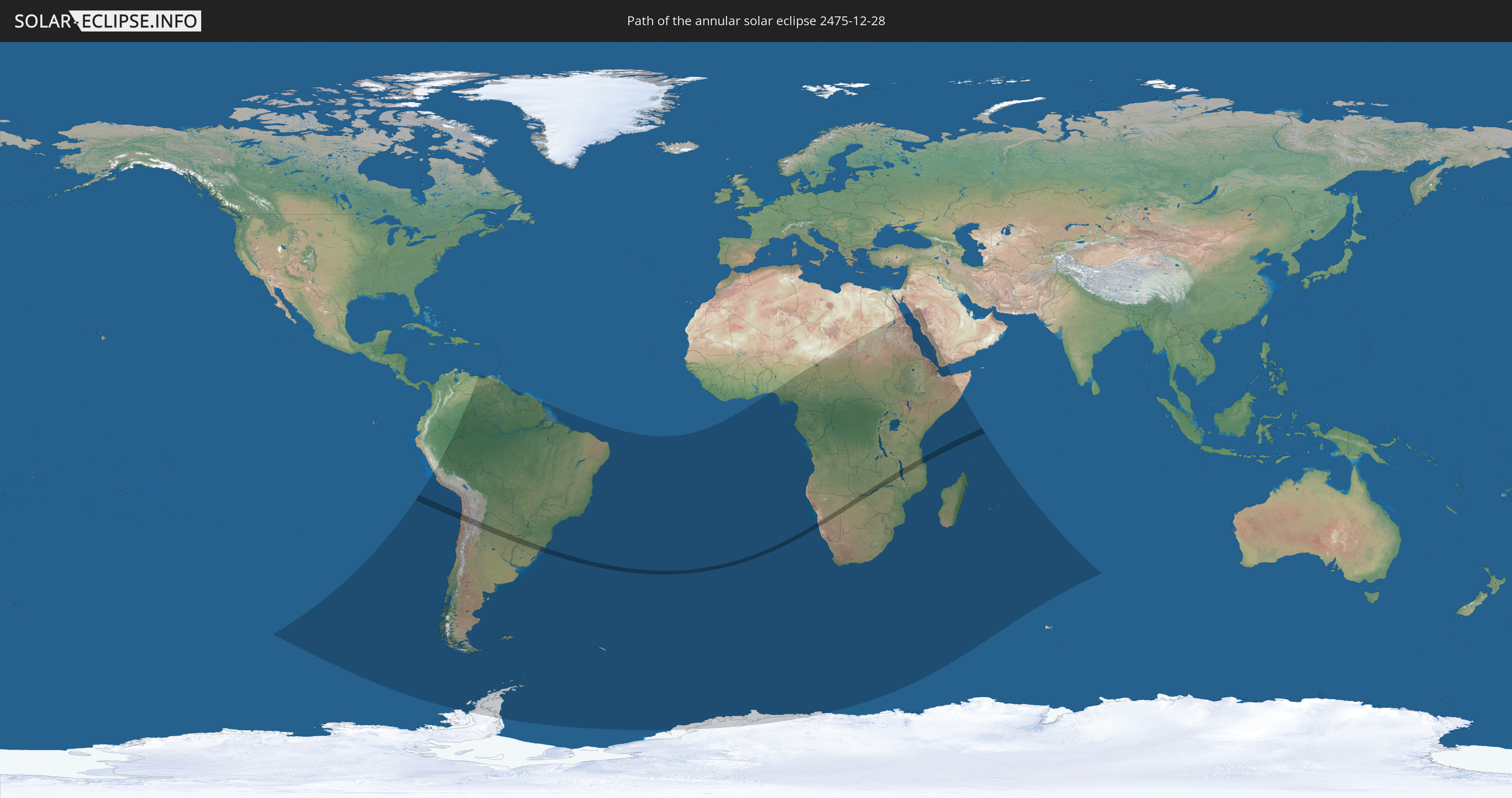
Die Sonnenfinsternis am 12/28/2475 kann man in 56 Ländern als partielle Sonnenfinsternis beobachten.
Der Finsternispfad verläuft durch 11 Länder. Nur in diesen Ländern ist sie als annular Sonnenfinsternis zu sehen.
In den folgenden Ländern ist die Sonnenfinsternis annular zu sehen
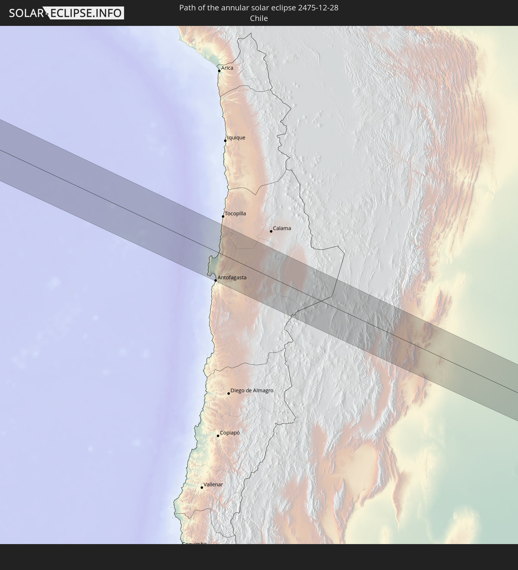 Chile
Chile
 Brazil
 Argentina
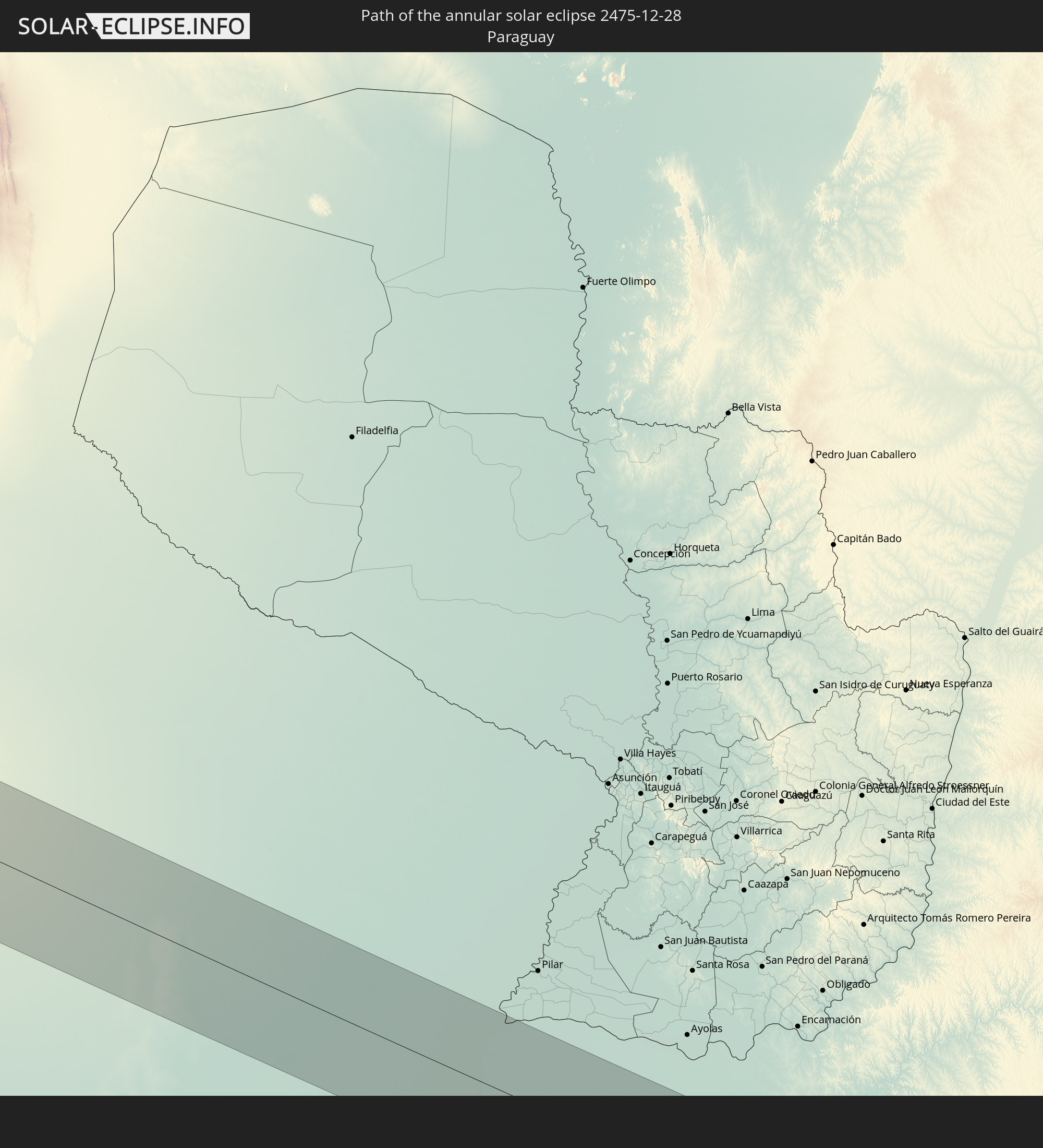 Paraguay
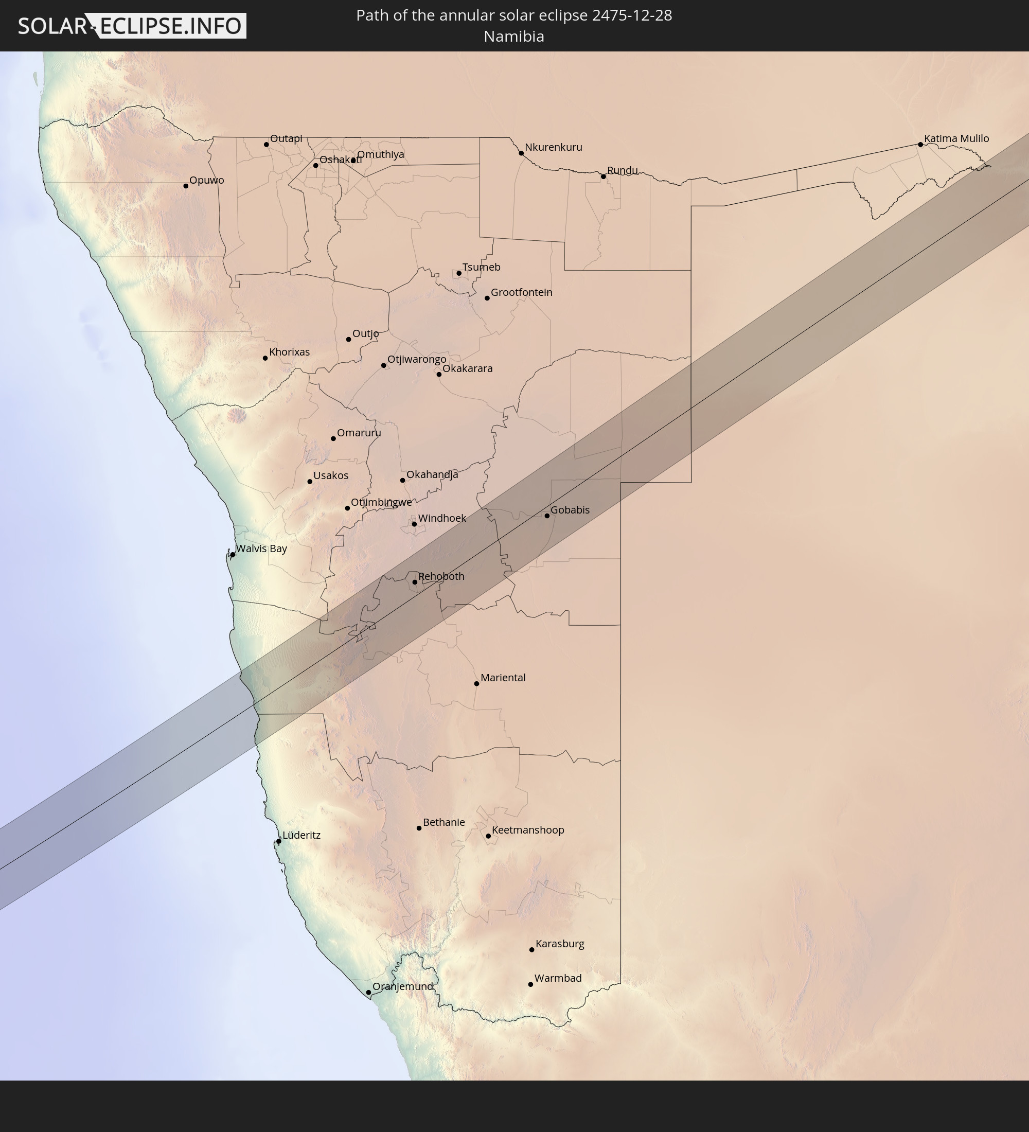 Namibia
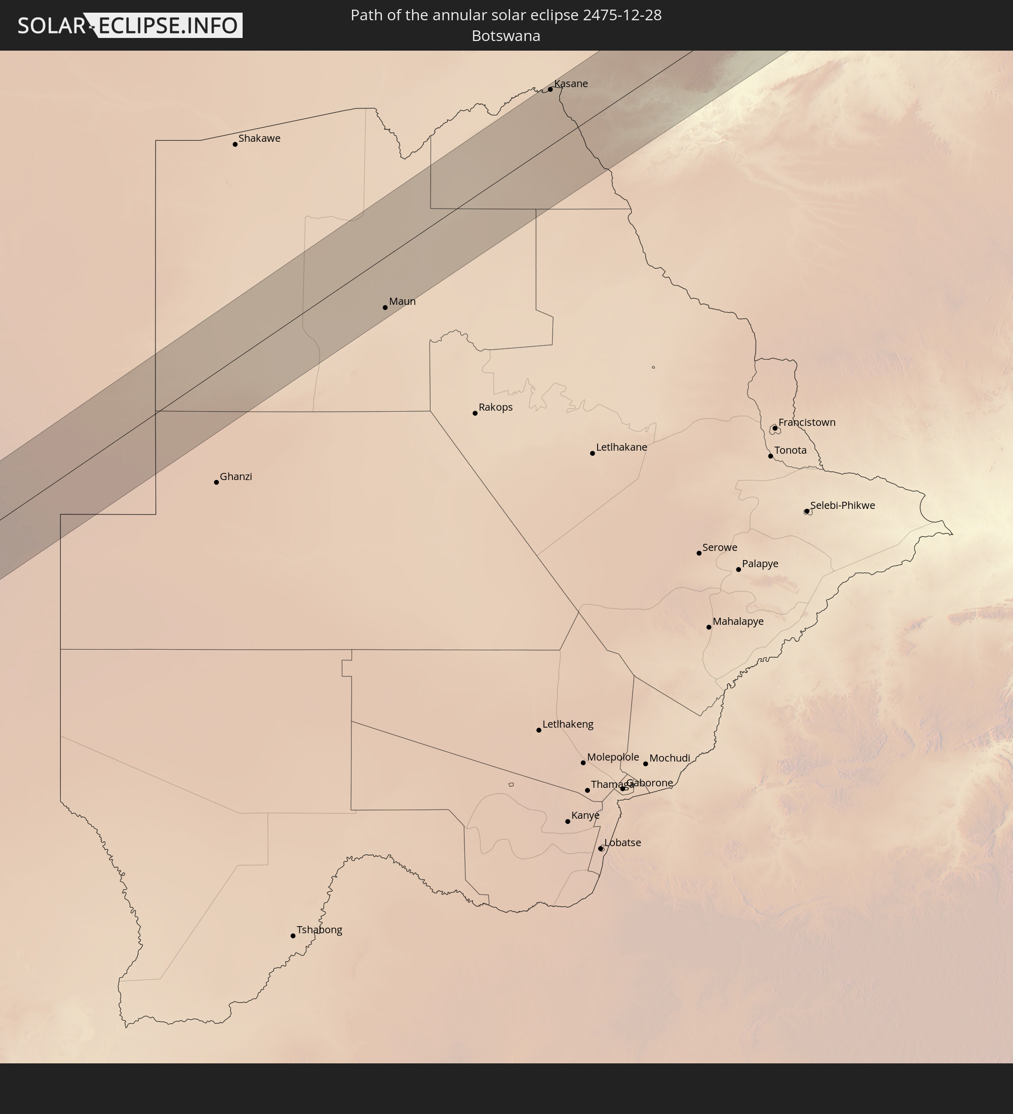 Botswana
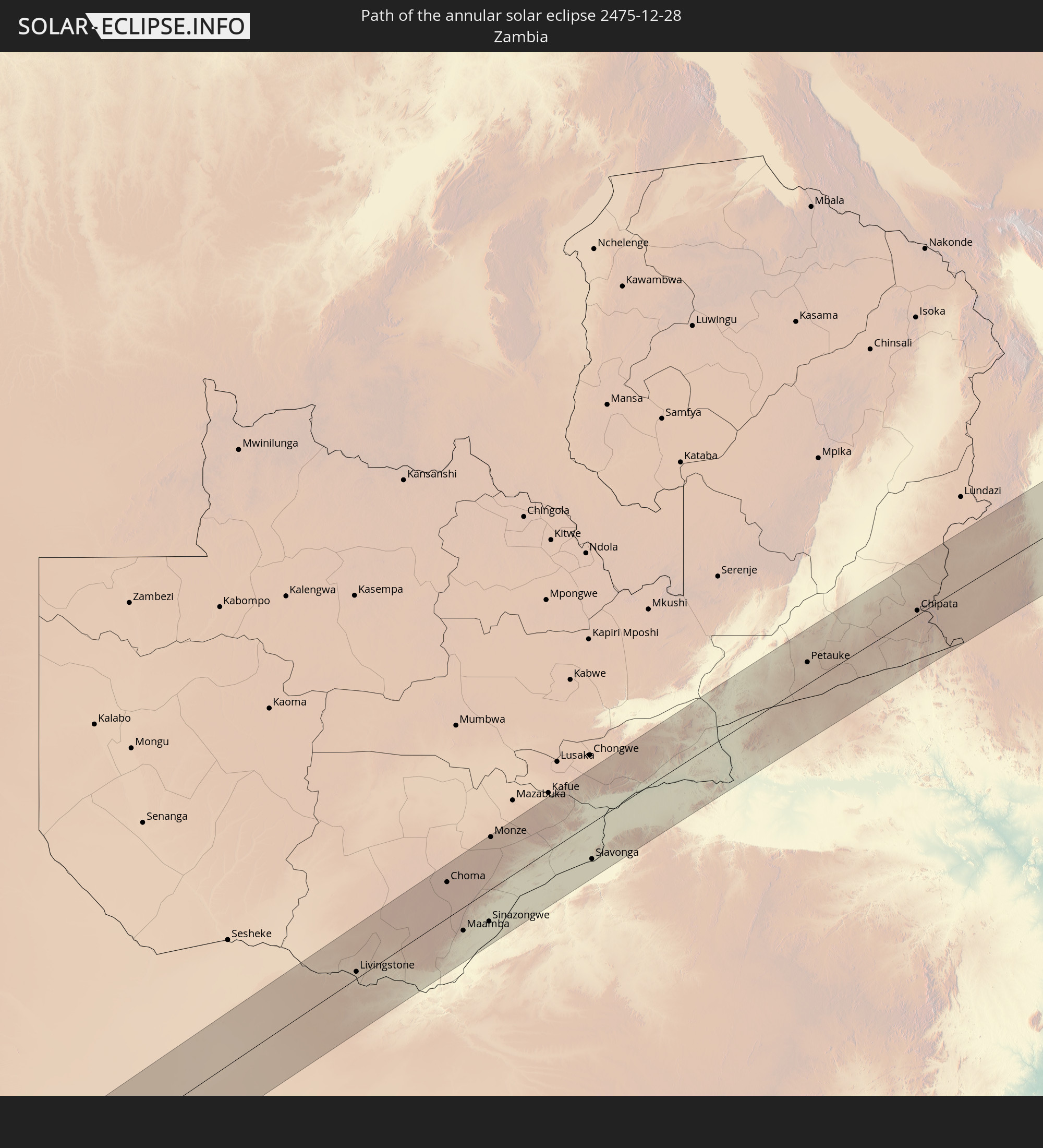 Zambia
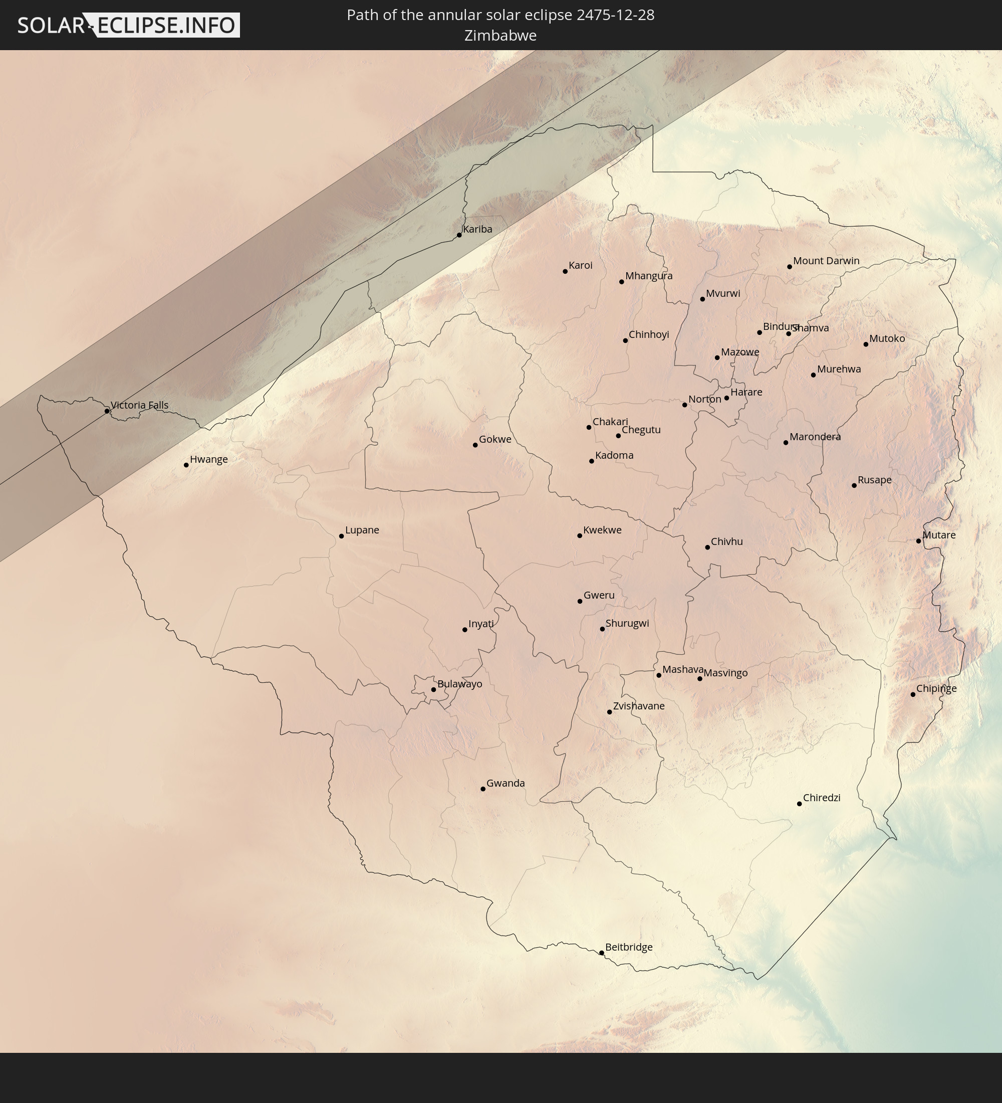 Zimbabwe
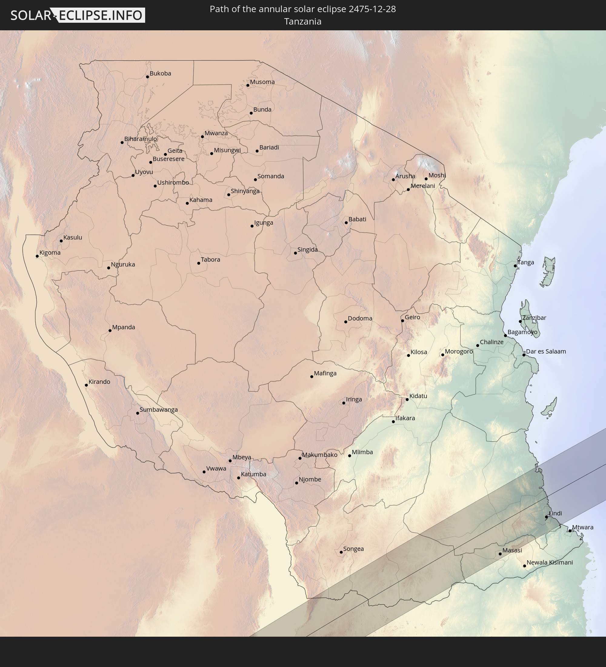 Tanzania
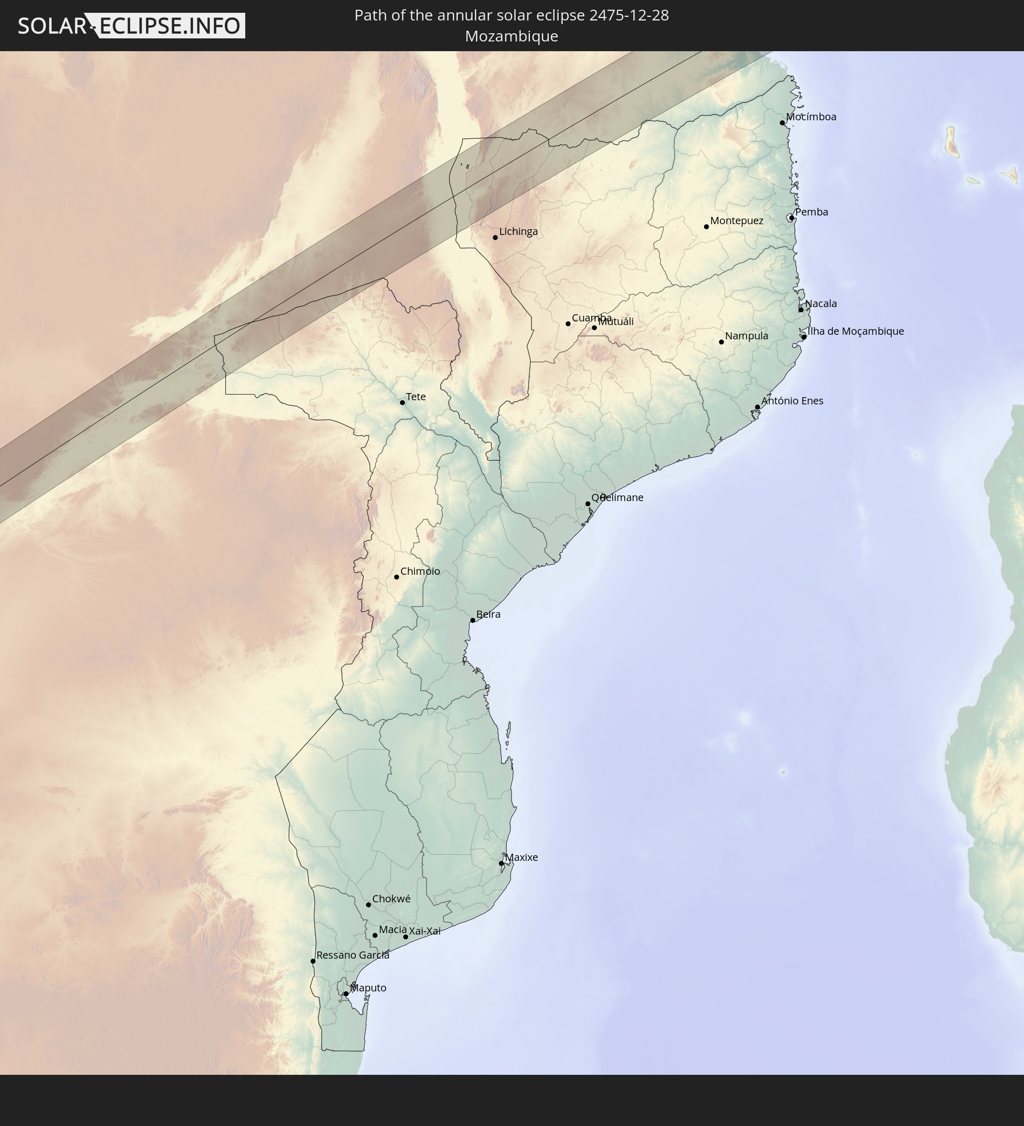 Mozambique
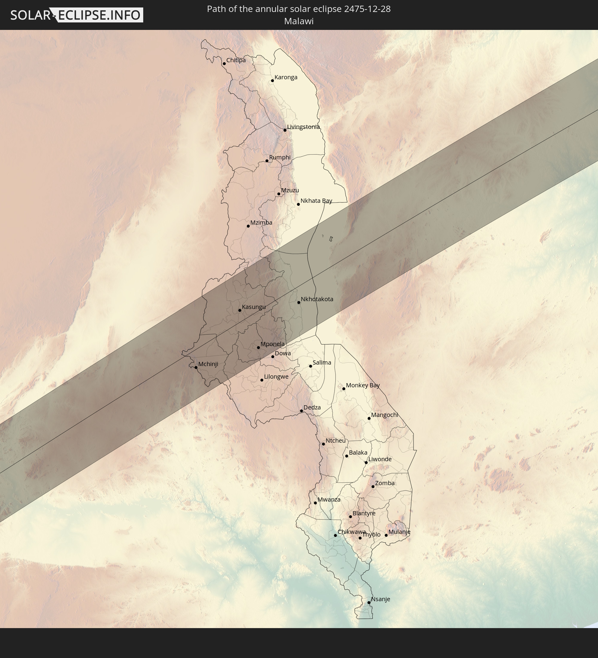 Malawi
In den folgenden Ländern ist die Sonnenfinsternis partiell zu sehen
 Antarctica
 Chile
Chile
 Colombia
 Peru
Peru
 Brazil
 Argentina
 Venezuela
 Bolivia
 Paraguay
 Falkland Islands
 Guyana
 Uruguay
 Suriname
 French Guiana
 South Georgia and the South Sandwich Islands
 Saint Helena, Ascension and Tristan da Cunha
 Nigeria
 Bouvet Island
 Equatorial Guinea
 São Tomé and Príncipe
 Cameroon
 Gabon
Gabon
 Republic of the Congo
 Angola
 Namibia
 Democratic Republic of the Congo
 Chad
Chad
 Central African Republic
 South Africa
 Botswana
 Sudan
Sudan
 Zambia
 Egypt
Egypt
 Zimbabwe
 Lesotho
 Rwanda
 Burundi
 Tanzania
 Uganda
 Mozambique
 Swaziland
 Malawi
 Ethiopia
 Kenya
Kenya
 Saudi Arabia
 Eritrea
 French Southern and Antarctic Lands
 Somalia
 Djibouti
 Yemen
Yemen
 Madagascar
 Comoros
 Mayotte
 Seychelles
 Réunion
 Mauritius
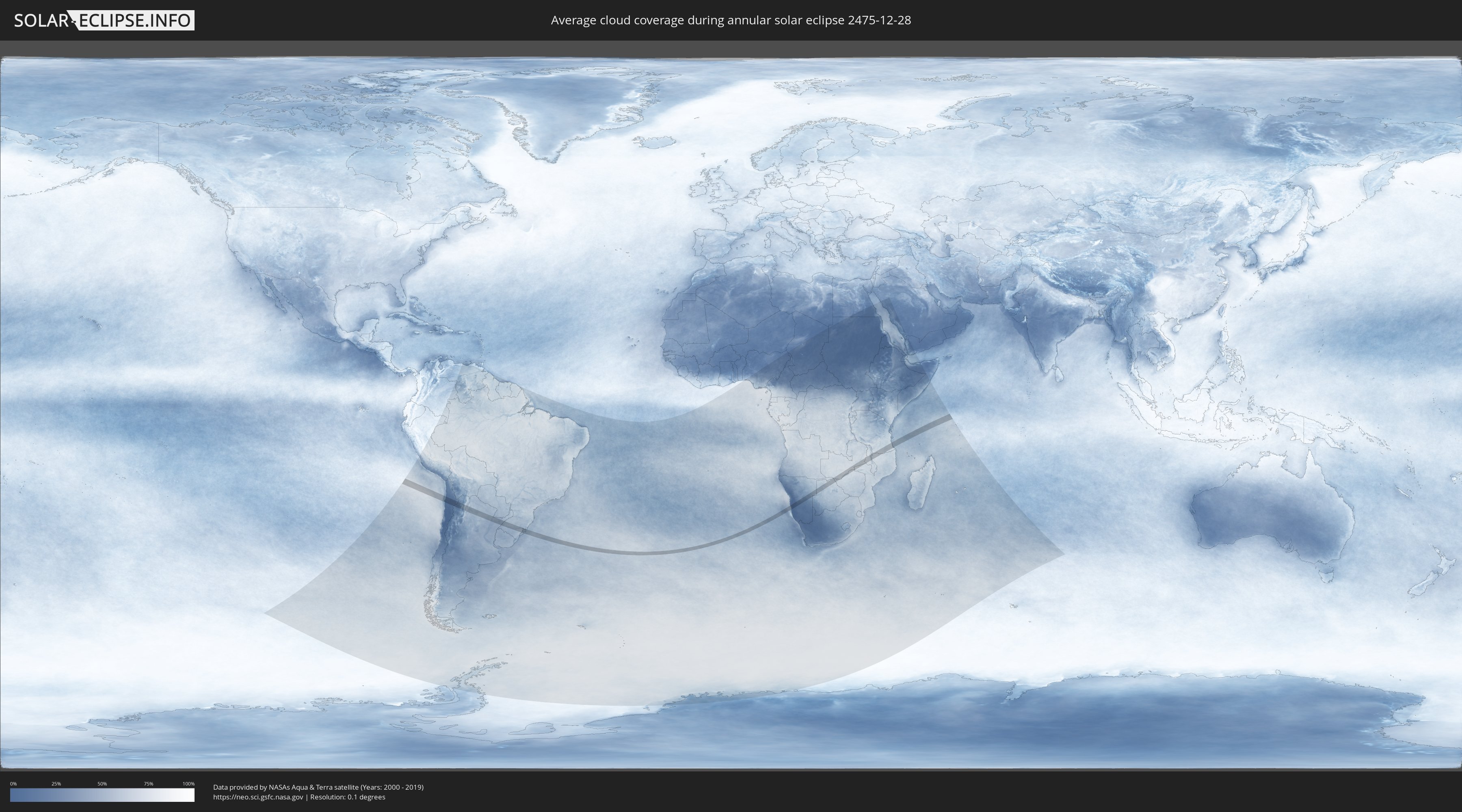
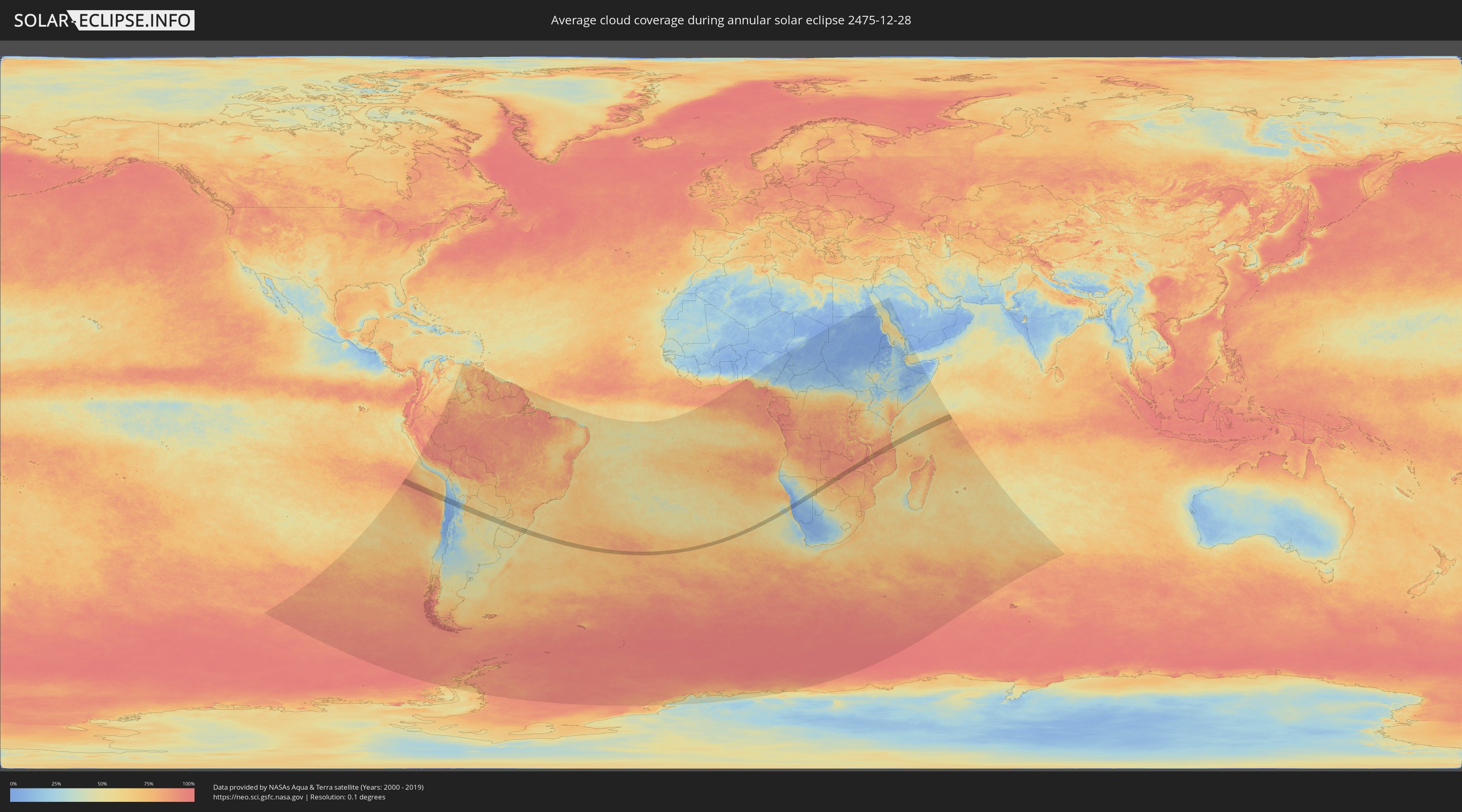
How will be the weather during the annular solar eclipse on 12/28/2475?
Where is the best place to see the annular solar eclipse of 12/28/2475?
The following maps show the average cloud coverage for the day of the annular solar eclipse.
With the help of these maps, it is possible to find the place along the eclipse path, which has the best
chance of a cloudless sky.
Nevertheless, you should consider local circumstances and inform about the weather of your chosen
observation site.
The data is provided by NASAs satellites
AQUA and TERRA.
The cloud maps are averaged over a period of 19 years (2000 - 2019).
Detailed country maps
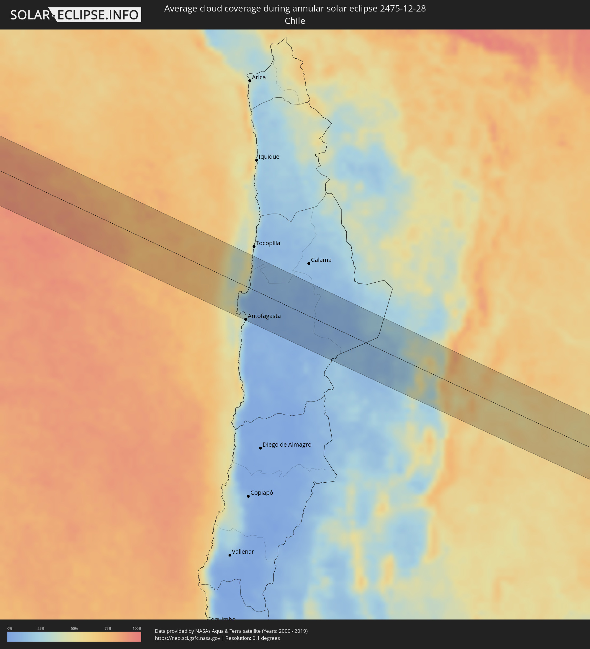 Chile
Chile
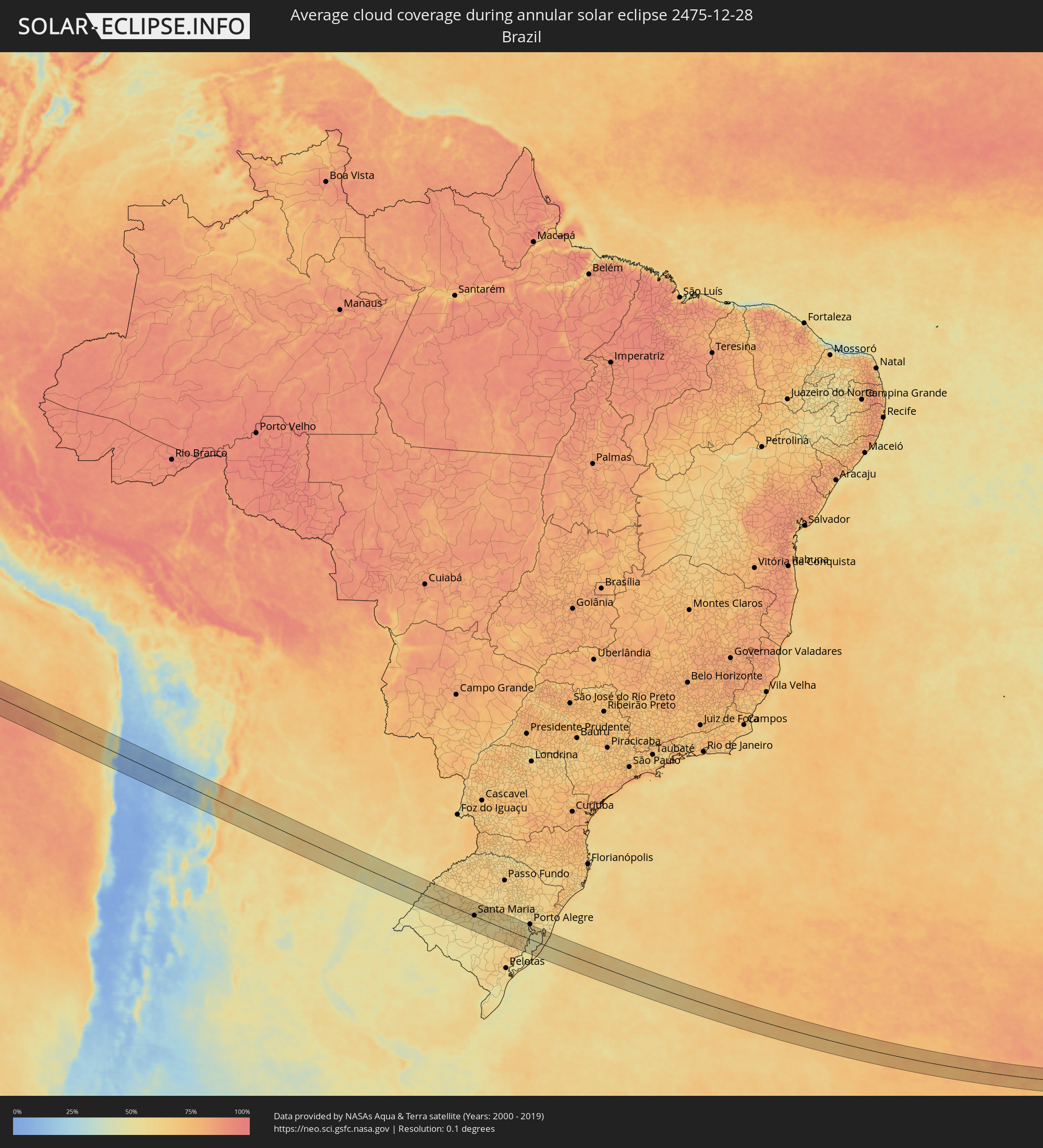 Brazil
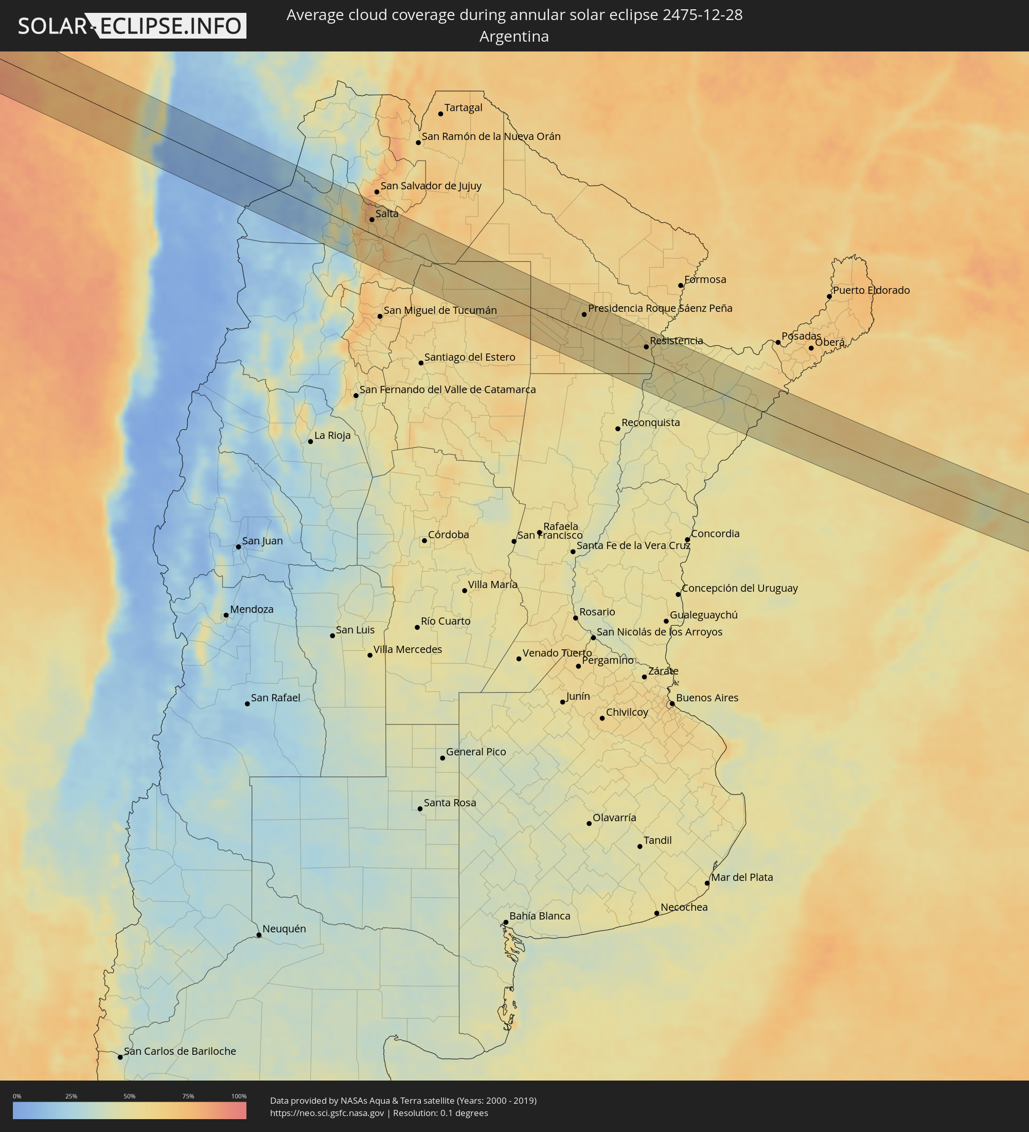 Argentina
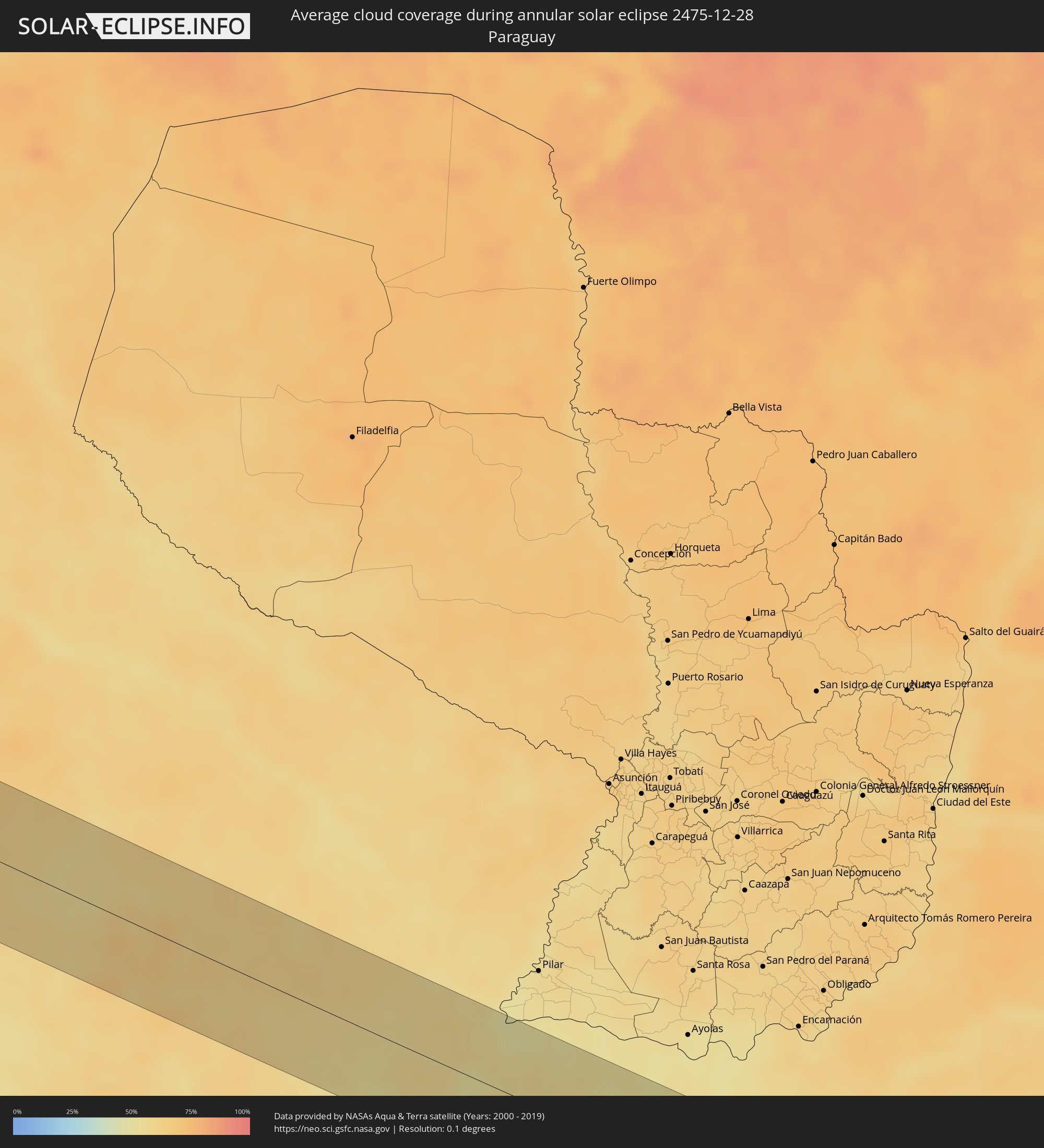 Paraguay
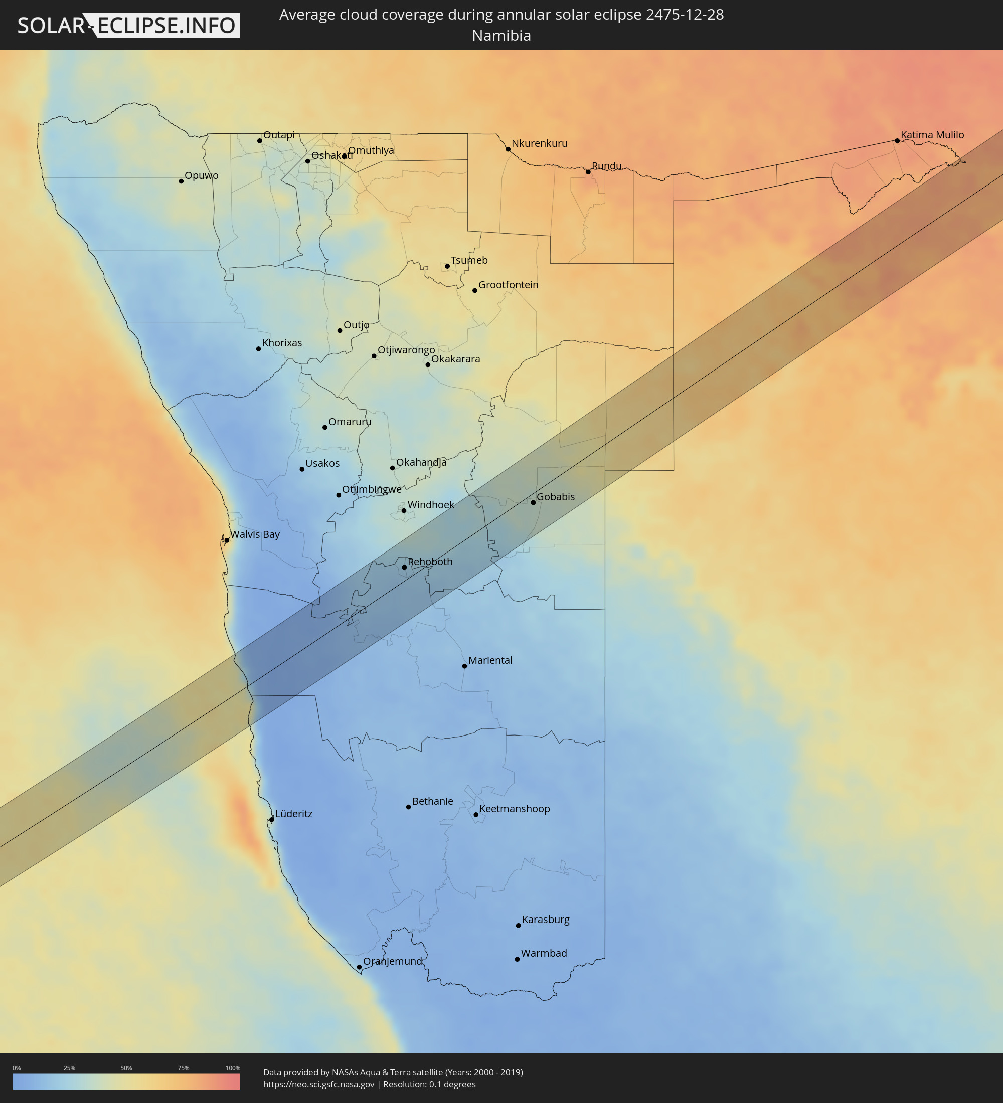 Namibia
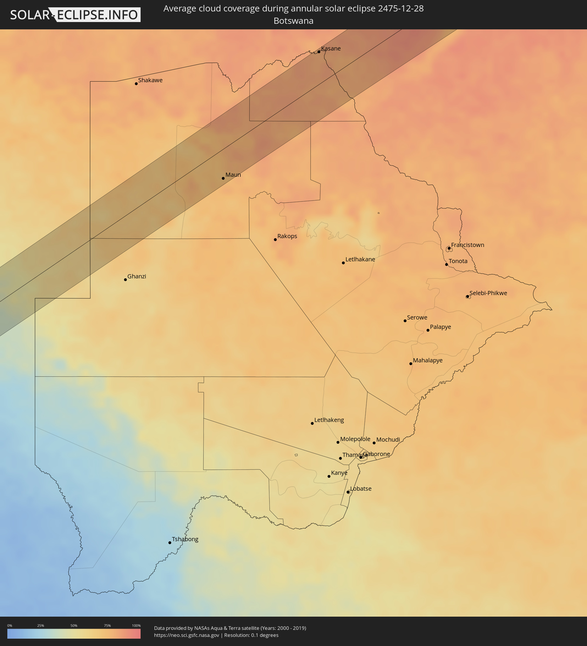 Botswana
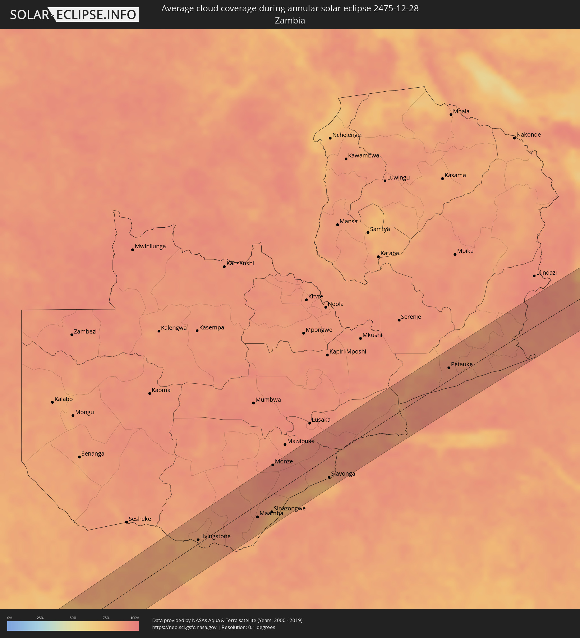 Zambia
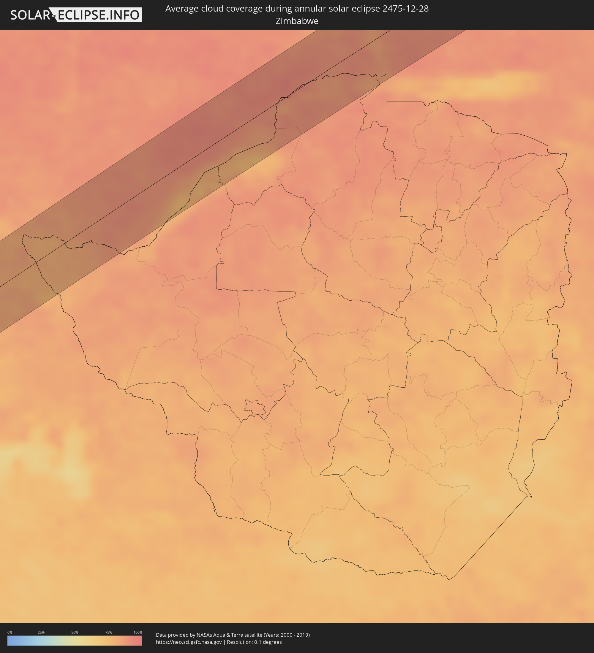 Zimbabwe
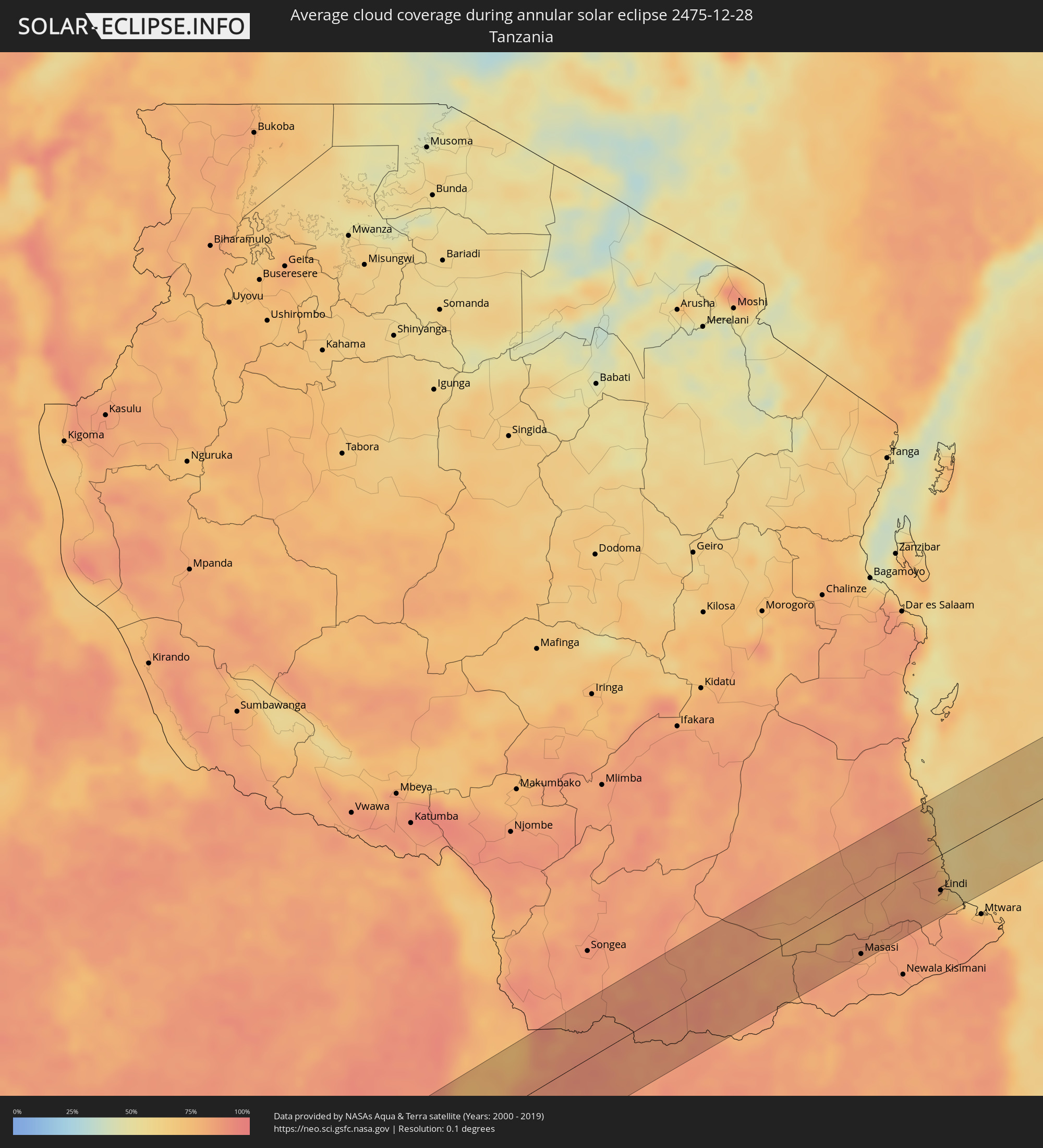 Tanzania
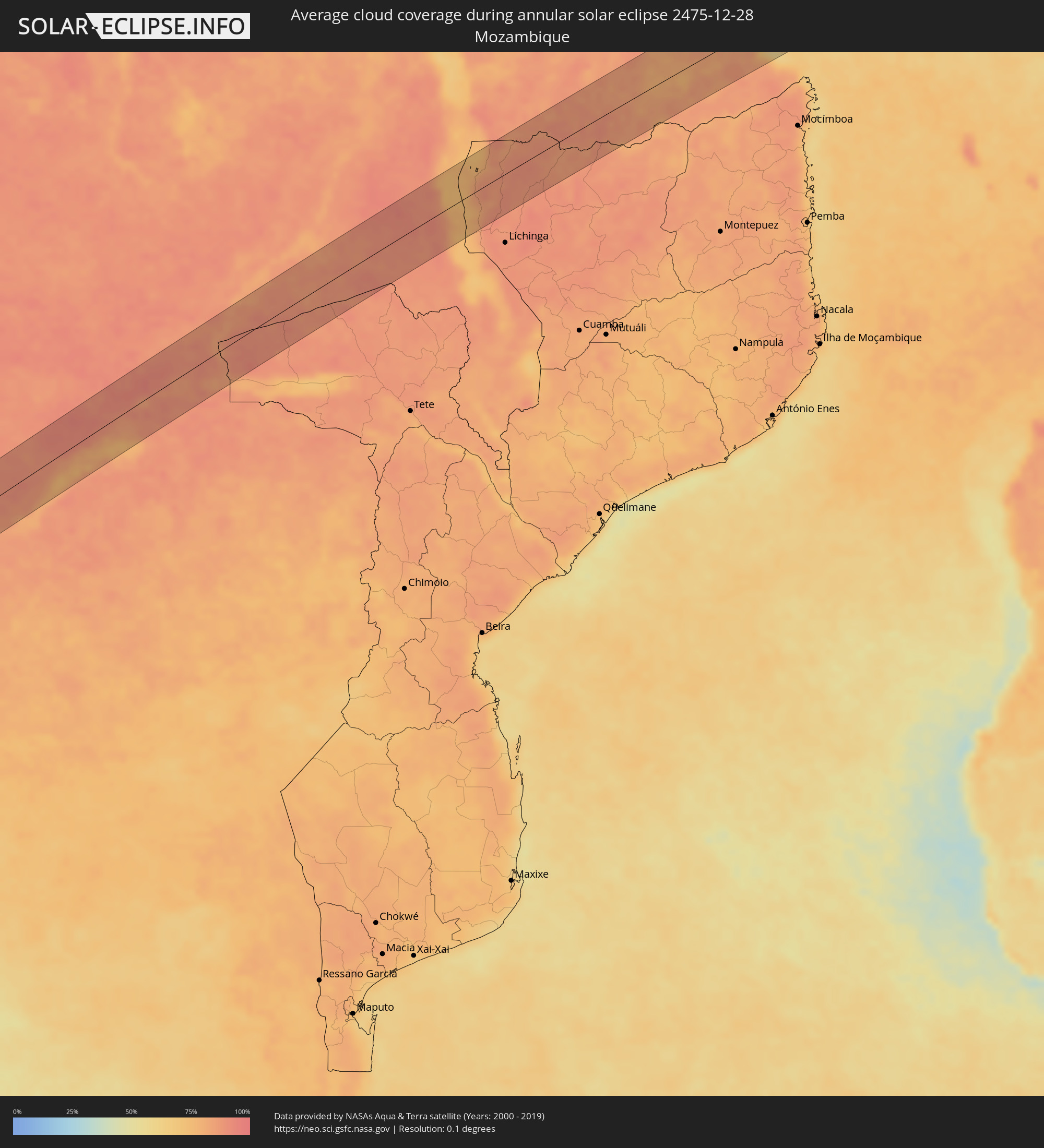 Mozambique
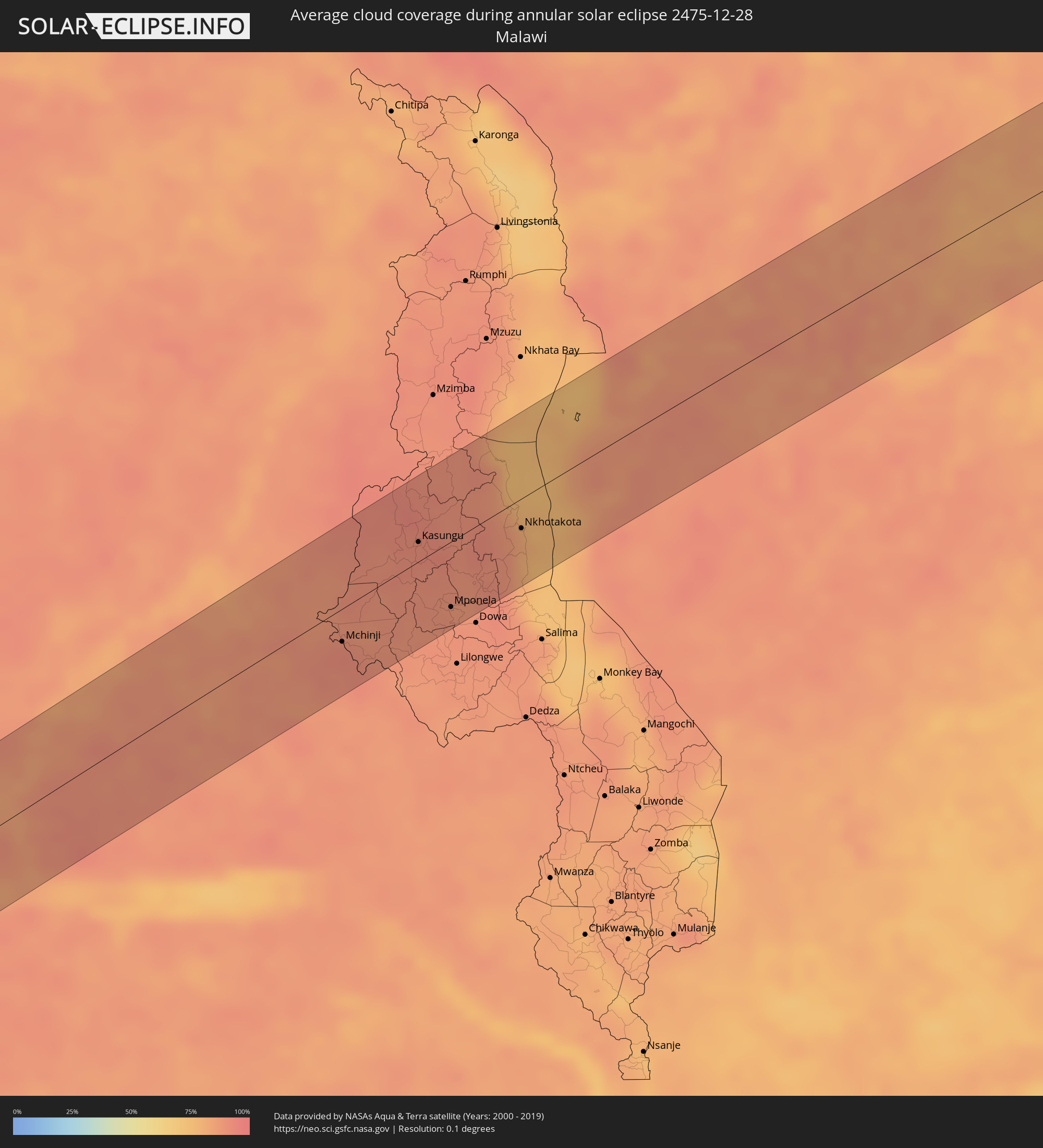 Malawi
Cities inside the path of the eclipse
The following table shows all locations with a population of more than 5,000 inside the eclipse path. Cities which have more than 100,000 inhabitants are marked bold. A click at the locations opens a detailed map.
| City | Type | Eclipse duration | Local time of max. eclipse | Distance to central line | Ø Cloud coverage |
|
Antofagasta, Antofagasta
|
annular | - | 07:53:04 UTC-03:00 | 72 km | 13% |
|
Chicoana, Salta Province
|
annular | - | 07:55:07 UTC-03:00 | 8 km | 58% |
|
El Carril, Salta Province
|
annular | - | 07:55:06 UTC-03:00 | 3 km | 58% |
|
Salta, Salta Province
|
annular | - | 07:54:51 UTC-03:00 | 29 km | 65% |
|
Joaquín V. González, Salta Province
|
annular | - | 07:55:28 UTC-03:00 | 52 km | 58% |
|
El Quebrachal, Salta Province
|
annular | - | 07:55:41 UTC-03:00 | 36 km | 53% |
|
Taco Pozo, Chaco Province
|
annular | - | 07:56:15 UTC-03:00 | 36 km | 60% |
|
Charata, Chaco Province
|
annular | - | 07:58:37 UTC-03:00 | 38 km | 59% |
|
Las Breñas, Chaco Province
|
annular | - | 07:58:32 UTC-03:00 | 21 km | 59% |
|
Corzuela, Chaco Province
|
annular | - | 07:58:27 UTC-03:00 | 3 km | 59% |
|
Campo Largo, Chaco Province
|
annular | - | 07:58:22 UTC-03:00 | 18 km | 59% |
|
Villa Ángela, Chaco Province
|
annular | - | 07:59:11 UTC-03:00 | 55 km | 60% |
|
San Bernardo, Chaco Province
|
annular | - | 07:58:54 UTC-03:00 | 26 km | 56% |
|
Presidencia Roque Sáenz Peña, Chaco Province
|
annular | - | 07:58:32 UTC-03:00 | 36 km | 61% |
|
Villa Berthet, Chaco Province
|
annular | - | 07:59:03 UTC-03:00 | 14 km | 56% |
|
Quitilipi, Chaco Province
|
annular | - | 07:58:43 UTC-03:00 | 37 km | 60% |
|
Machagai, Chaco Province
|
annular | - | 07:58:51 UTC-03:00 | 38 km | 59% |
|
Presidencia de la Plaza, Chaco Province
|
annular | - | 07:59:02 UTC-03:00 | 38 km | 57% |
|
Puerto Tirol, Chaco Province
|
annular | - | 07:59:47 UTC-03:00 | 32 km | 58% |
|
Resistencia, Chaco Province
|
annular | - | 07:59:56 UTC-03:00 | 27 km | 53% |
|
San Lorenzo, Corrientes Province
|
annular | - | 08:00:44 UTC-03:00 | 33 km | 48% |
|
Saladas, Corrientes Province
|
annular | - | 08:00:56 UTC-03:00 | 39 km | 49% |
|
San Luis del Palmar, Corrientes Province
|
annular | - | 08:00:12 UTC-03:00 | 39 km | 53% |
|
Mburucuyá, Corrientes Province
|
annular | - | 08:00:56 UTC-03:00 | 2 km | 50% |
|
La Cruz, Corrientes Province
|
annular | - | 08:03:05 UTC-03:00 | 54 km | 48% |
|
Itaqui, Rio Grande do Sul
|
annular | - | 08:03:05 UTC-03:00 | 46 km | 52% |
|
Santo Tomé, Corrientes Province
|
annular | - | 08:02:49 UTC-03:00 | 33 km | 52% |
|
São Borja, Rio Grande do Sul
|
annular | - | 08:02:57 UTC-03:00 | 23 km | 53% |
|
São Francisco de Assis, Rio Grande do Sul
|
annular | - | 08:04:30 UTC-03:00 | 34 km | 55% |
|
Santiago, Rio Grande do Sul
|
annular | - | 08:04:18 UTC-03:00 | 13 km | 62% |
|
Cacequi, Rio Grande do Sul
|
annular | - | 08:05:05 UTC-03:00 | 57 km | 53% |
|
São Pedro do Sul, Rio Grande do Sul
|
annular | - | 08:05:16 UTC-03:00 | 5 km | 57% |
|
Santa Maria, Rio Grande do Sul
|
annular | - | 08:05:38 UTC-03:00 | 2 km | 58% |
|
Júlio de Castilhos, Rio Grande do Sul
|
annular | - | 08:05:14 UTC-03:00 | 54 km | 62% |
|
São Sepé, Rio Grande do Sul
|
annular | - | 08:06:20 UTC-03:00 | 37 km | 56% |
|
Cachoeira do Sul, Rio Grande do Sul
|
annular | - | 08:06:44 UTC-03:00 | 0 km | 54% |
|
Candelária, Rio Grande do Sul
|
annular | - | 08:06:26 UTC-03:00 | 42 km | 58% |
|
Encruzilhada do Sul, Rio Grande do Sul
|
annular | - | 08:07:36 UTC-03:00 | 38 km | 60% |
|
Santa Cruz do Sul, Rio Grande do Sul
|
annular | - | 08:06:47 UTC-03:00 | 50 km | 61% |
|
Rio Pardo, Rio Grande do Sul
|
annular | - | 08:07:07 UTC-03:00 | 24 km | 53% |
|
Butiá, Rio Grande do Sul
|
annular | - | 08:07:37 UTC-03:00 | 26 km | 60% |
|
Camaquã, Rio Grande do Sul
|
annular | - | 08:08:33 UTC-03:00 | 44 km | 61% |
|
Arroio dos Ratos, Rio Grande do Sul
|
annular | - | 08:07:46 UTC-03:00 | 39 km | 59% |
|
São Jerônimo, Rio Grande do Sul
|
annular | - | 08:07:39 UTC-03:00 | 51 km | 57% |
|
Triunfo, Rio Grande do Sul
|
annular | - | 08:07:38 UTC-03:00 | 53 km | 51% |
|
Charqueadas, Rio Grande do Sul
|
annular | - | 08:07:44 UTC-03:00 | 55 km | 57% |
|
Tapes, Rio Grande do Sul
|
annular | - | 08:08:43 UTC-03:00 | 11 km | 52% |
|
Guaíba, Rio Grande do Sul
|
annular | - | 08:08:10 UTC-03:00 | 50 km | 53% |
|
Rehoboth, Hardap
|
annular | - | 15:47:40 UTC+02:00 | 16 km | 18% |
|
Gobabis, Omaheke
|
annular | - | 15:51:36 UTC+02:00 | 13 km | 35% |
|
Maun, North-West
|
annular | - | 16:00:35 UTC+02:00 | 47 km | 77% |
|
Kasane, North-West
|
annular | - | 16:05:28 UTC+02:00 | 51 km | 79% |
|
Livingstone, Southern
|
annular | - | 16:06:03 UTC+02:00 | 7 km | 82% |
|
Maamba, Southern
|
annular | - | 16:07:48 UTC+02:00 | 25 km | 85% |
|
Sinazongwe, Southern
|
annular | - | 16:08:12 UTC+02:00 | 34 km | 75% |
|
Monze, Southern
|
annular | - | 16:09:34 UTC+02:00 | 56 km | 92% |
|
Siavonga, Southern
|
annular | - | 16:10:08 UTC+02:00 | 39 km | 82% |
|
Petauke, Eastern
|
annular | - | 16:14:50 UTC+02:00 | 24 km | 88% |
|
Mchinji, Central Region
|
annular | - | 16:16:13 UTC+02:00 | 24 km | 92% |
|
Kasungu, Central Region
|
annular | - | 16:17:27 UTC+02:00 | 14 km | 91% |
|
Mponela, Central Region
|
annular | - | 16:16:58 UTC+02:00 | 48 km | 89% |
|
Ntchisi, Central Region
|
annular | - | 16:17:03 UTC+02:00 | 57 km | 89% |
|
Nkhotakota, Central Region
|
annular | - | 16:17:56 UTC+02:00 | 22 km | 81% |
|
Nangomba, Mtwara
|
annular | - | 17:21:40 UTC+03:00 | 61 km | 84% |
|
Nachingwea, Lindi
|
annular | - | 17:22:17 UTC+03:00 | 24 km | 84% |
|
Lukuledi, Mtwara
|
annular | - | 17:22:05 UTC+03:00 | 45 km | 84% |
|
Masasi, Mtwara
|
annular | - | 17:21:56 UTC+03:00 | 59 km | 81% |
|
Ruangwa, Lindi
|
annular | - | 17:22:38 UTC+03:00 | 4 km | 81% |
|
Mbekenyera, Lindi
|
annular | - | 17:22:43 UTC+03:00 | 0 km | 83% |
|
Nanganga, Mtwara
|
annular | - | 17:22:22 UTC+03:00 | 46 km | 86% |
|
Nyangao, Lindi
|
annular | - | 17:22:27 UTC+03:00 | 49 km | 87% |
|
Mtama, Lindi
|
annular | - | 17:22:30 UTC+03:00 | 50 km | 86% |
|
Mingoyo, Lindi
|
annular | - | 17:22:45 UTC+03:00 | 44 km | 81% |
|
Lindi, Lindi
|
annular | - | 17:22:53 UTC+03:00 | 39 km | 73% |