Total solar eclipse of 10/15/2479
| Day of week: | Sunday |
| Maximum duration of eclipse: | 04m18s |
| Maximum width of eclipse path: | 166 km |
| Saros cycle: | 151 |
| Coverage: | 100% |
| Magnitude: | 1.0484 |
| Gamma: | -0.2538 |
Wo kann man die Sonnenfinsternis vom 10/15/2479 sehen?
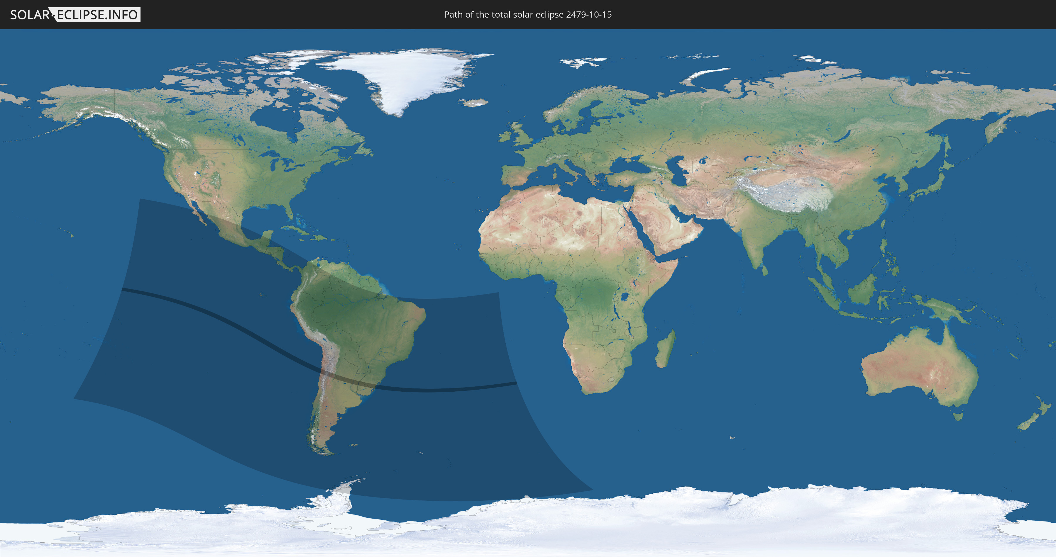
Die Sonnenfinsternis am 10/15/2479 kann man in 27 Ländern als partielle Sonnenfinsternis beobachten.
Der Finsternispfad verläuft durch 4 Länder. Nur in diesen Ländern ist sie als total Sonnenfinsternis zu sehen.
In den folgenden Ländern ist die Sonnenfinsternis total zu sehen
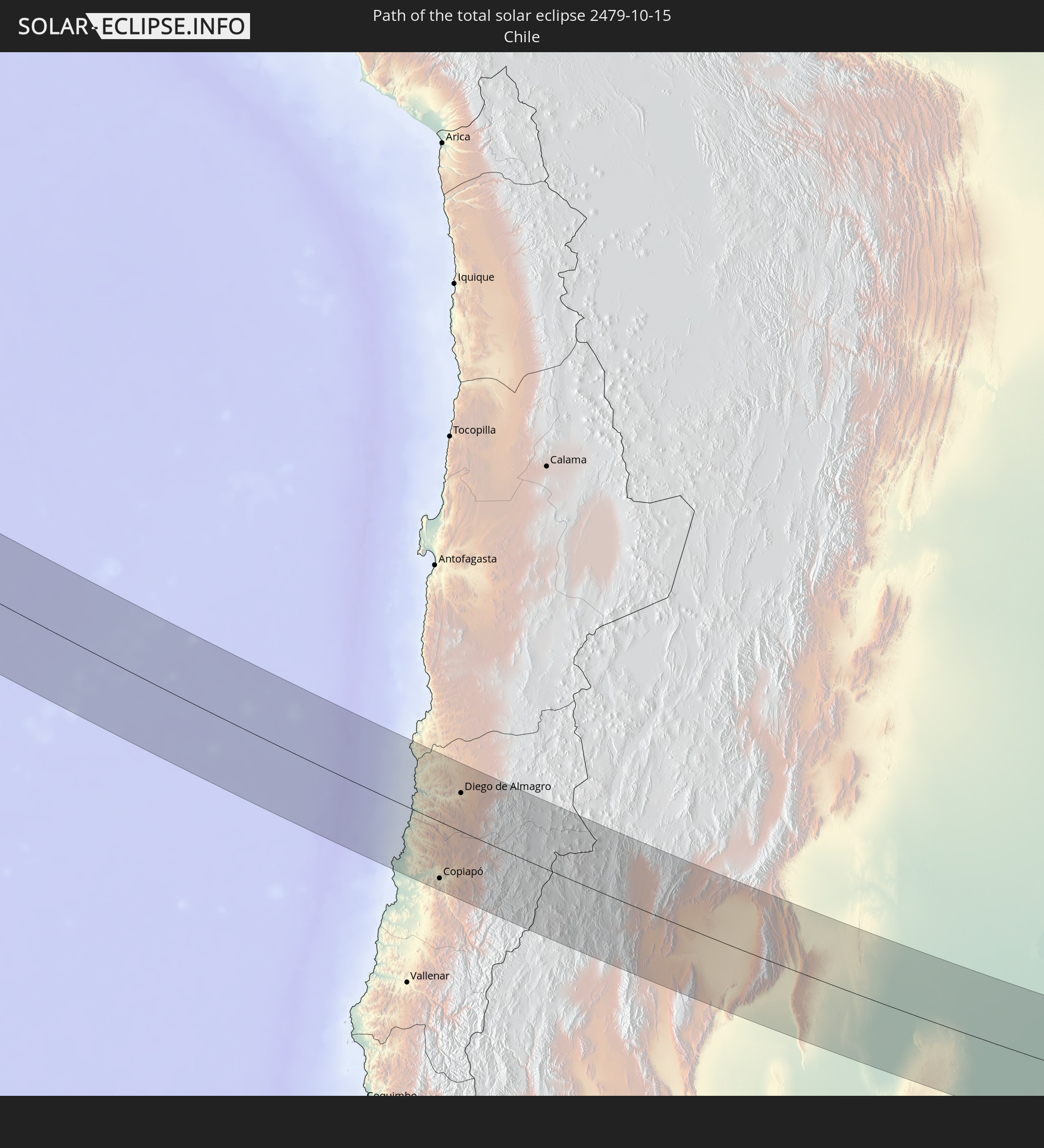 Chile
Chile
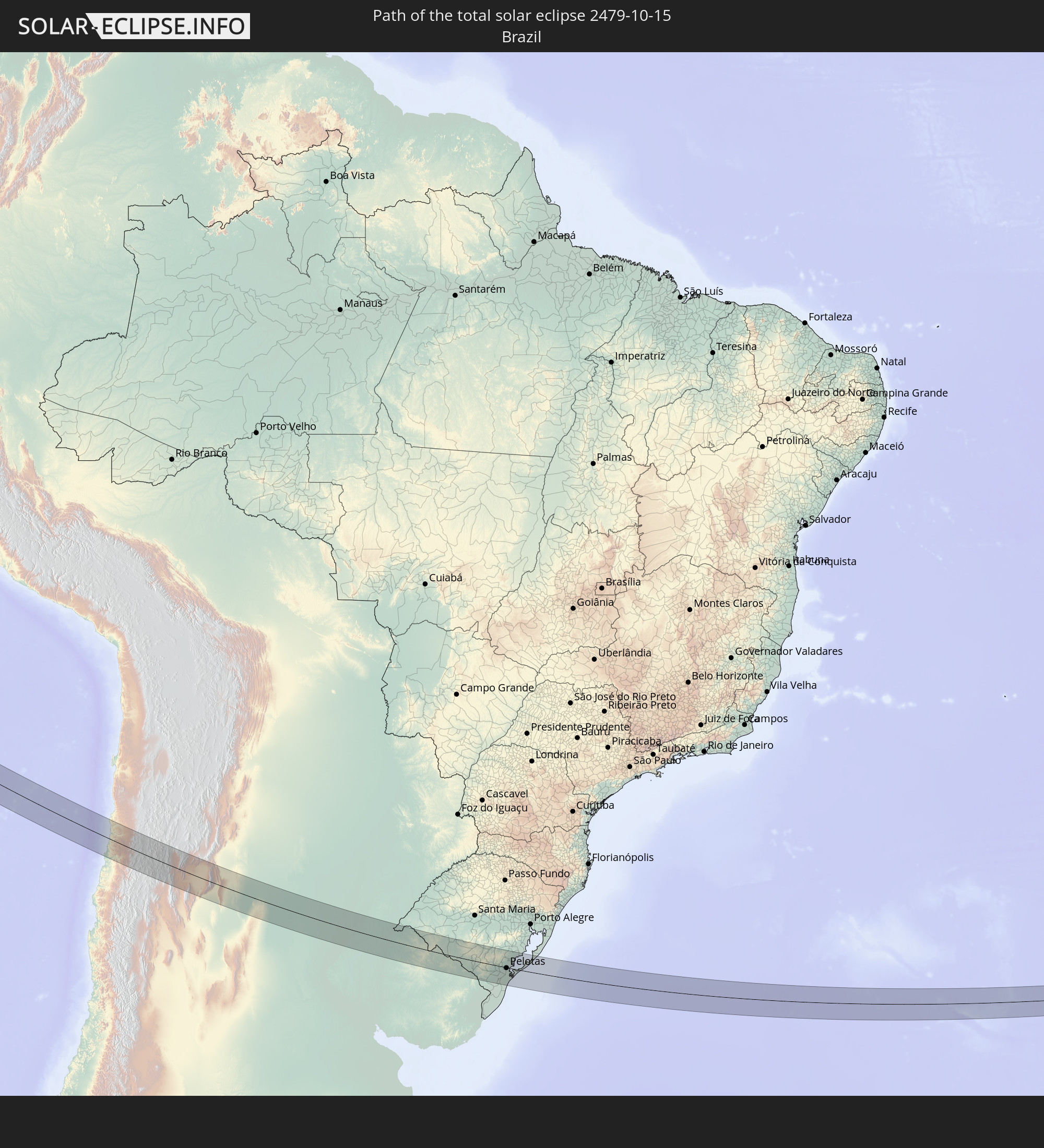 Brazil
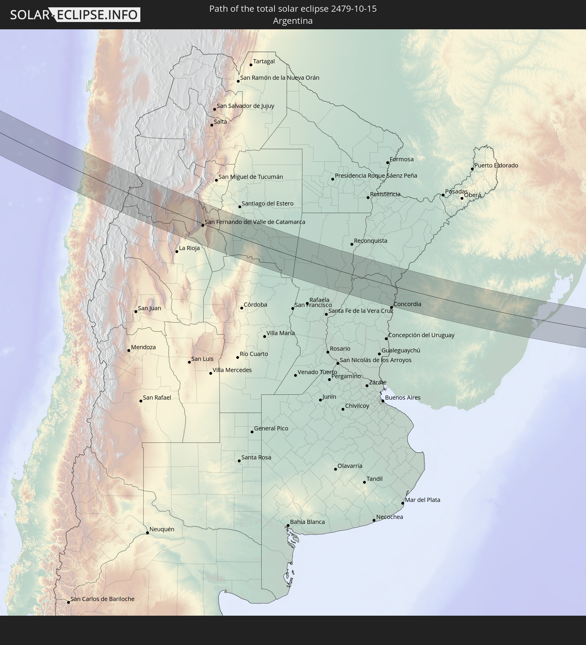 Argentina
 Uruguay
In den folgenden Ländern ist die Sonnenfinsternis partiell zu sehen
 Antarctica
 Kiribati
 French Polynesia
 Pitcairn Islands
 Mexico
 Chile
Chile
 Guatemala
 Ecuador
 El Salvador
 Honduras
 Belize
 Nicaragua
 Costa Rica
 Panama
 Colombia
 Peru
Peru
 Brazil
 Argentina
 Venezuela
 Bolivia
 Paraguay
 Falkland Islands
 Guyana
 Uruguay
 South Georgia and the South Sandwich Islands
 Saint Helena, Ascension and Tristan da Cunha
 Bouvet Island
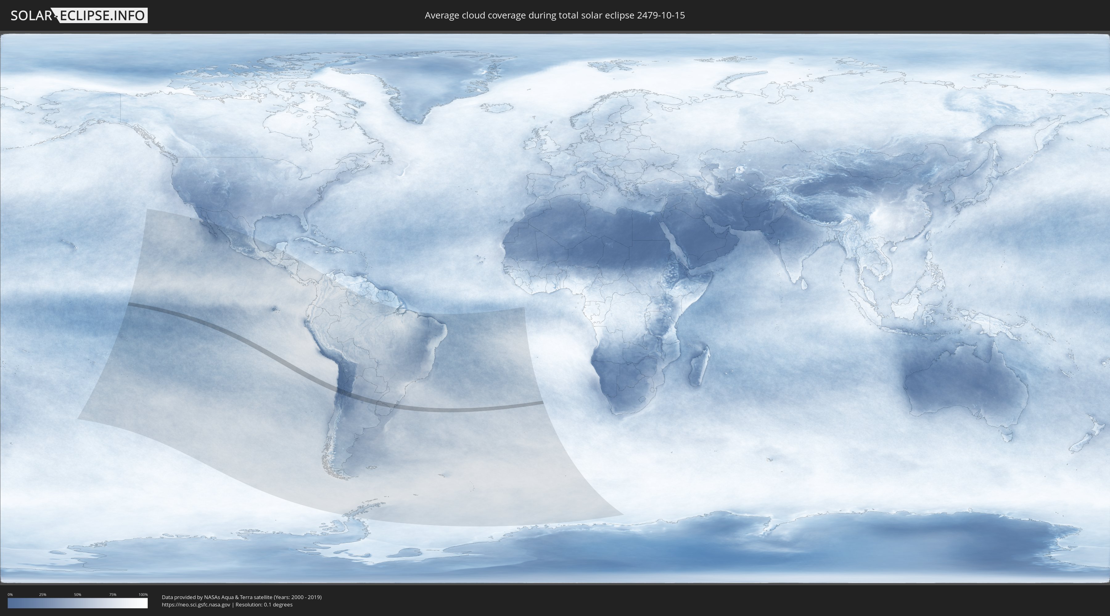
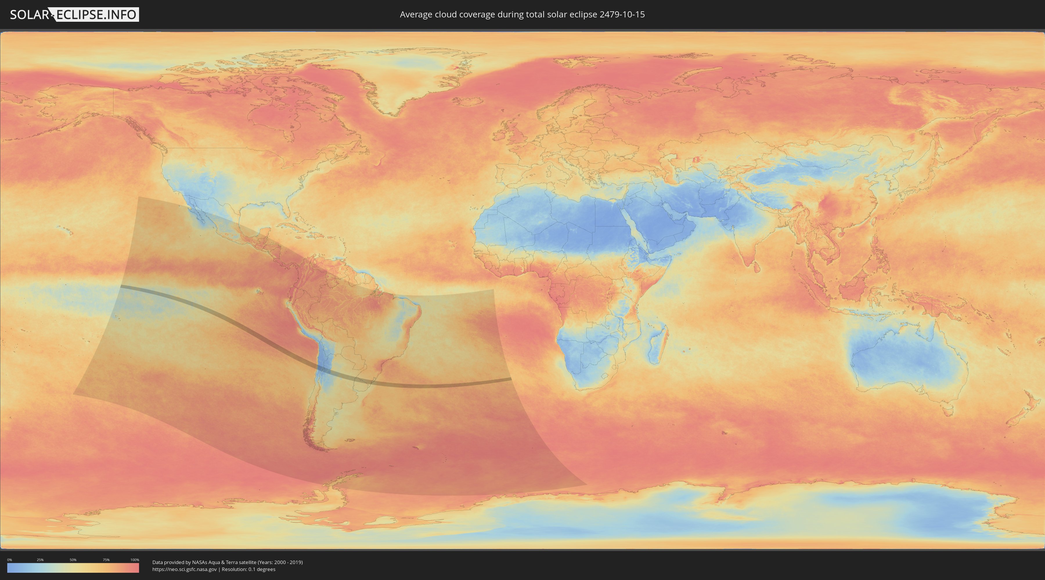
How will be the weather during the total solar eclipse on 10/15/2479?
Where is the best place to see the total solar eclipse of 10/15/2479?
The following maps show the average cloud coverage for the day of the total solar eclipse.
With the help of these maps, it is possible to find the place along the eclipse path, which has the best
chance of a cloudless sky.
Nevertheless, you should consider local circumstances and inform about the weather of your chosen
observation site.
The data is provided by NASAs satellites
AQUA and TERRA.
The cloud maps are averaged over a period of 19 years (2000 - 2019).
Detailed country maps
 Chile
Chile
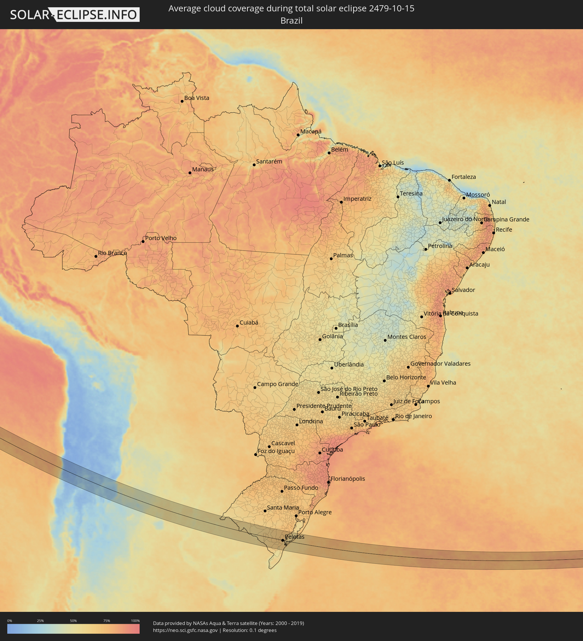 Brazil
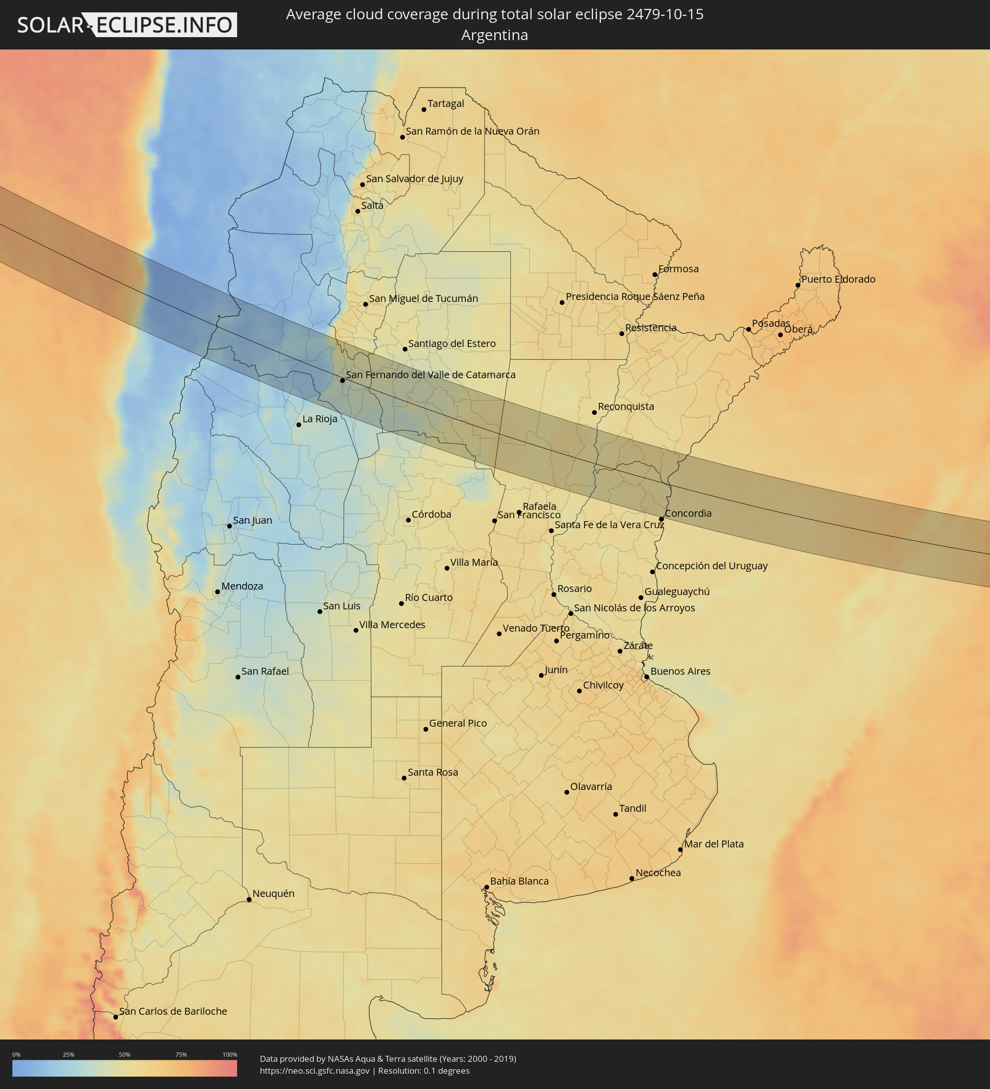 Argentina
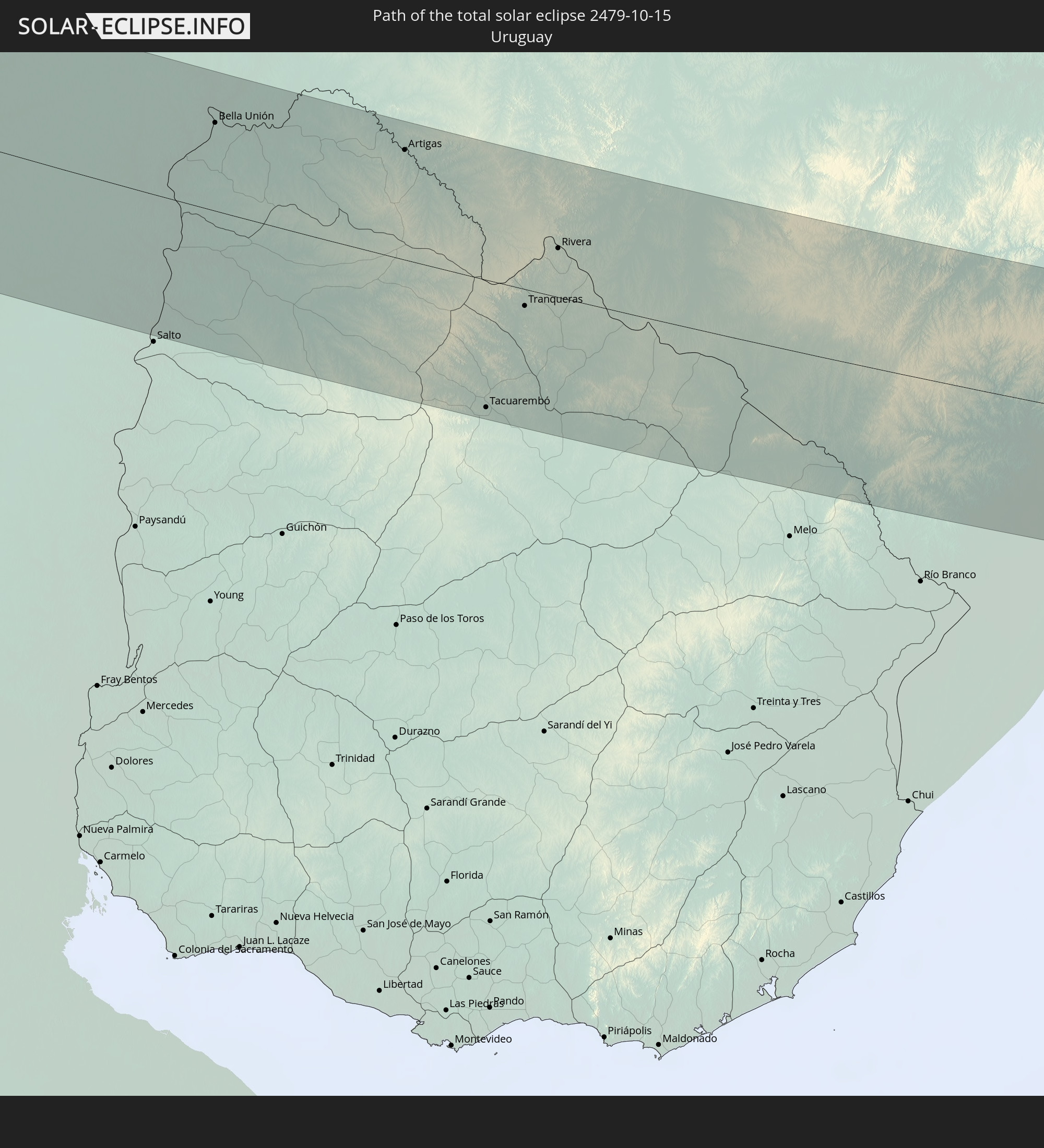
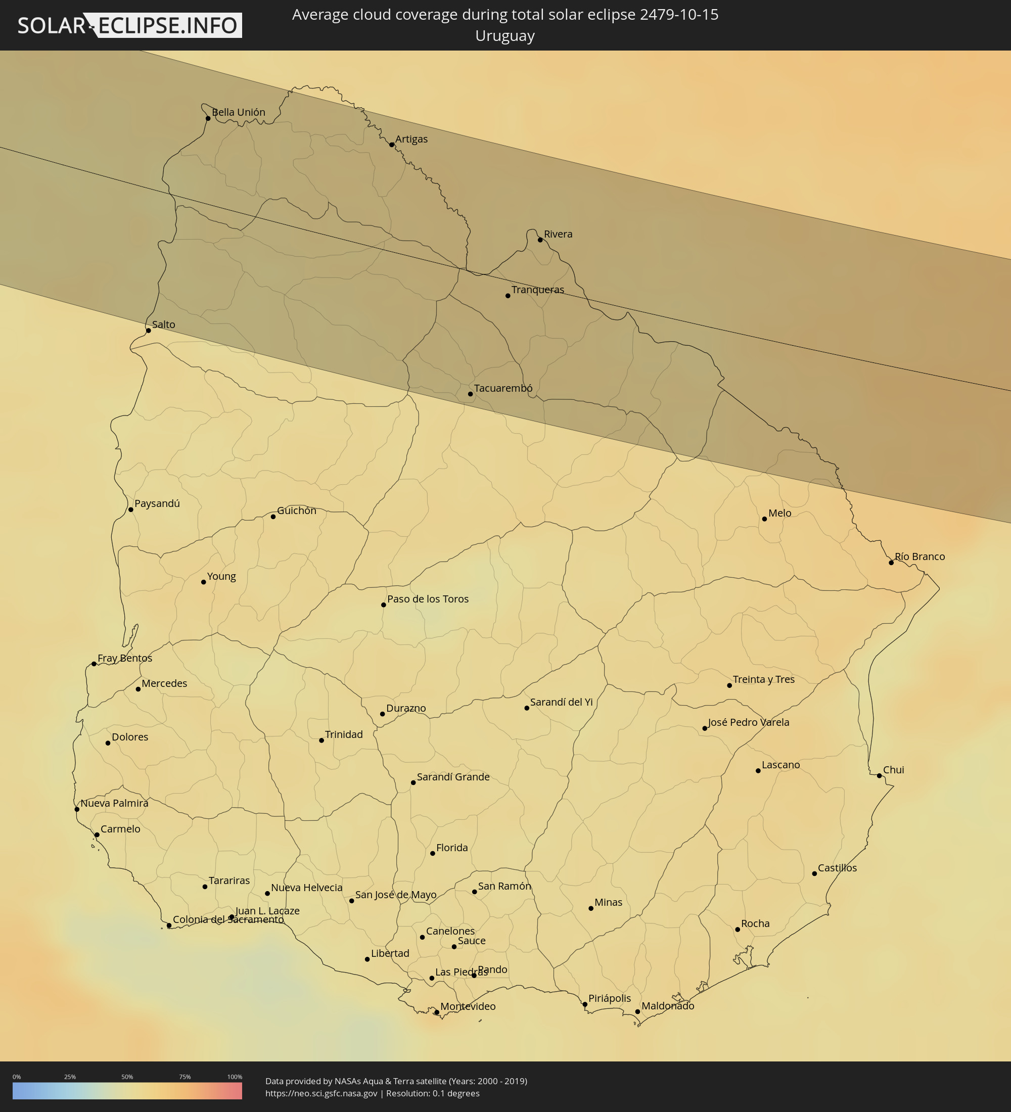 Uruguay
Cities inside the path of the eclipse
The following table shows all locations with a population of more than 5,000 inside the eclipse path. Cities which have more than 100,000 inhabitants are marked bold. A click at the locations opens a detailed map.
| City | Type | Eclipse duration | Local time of max. eclipse | Distance to central line | Ø Cloud coverage |
|
Copiapó, Atacama
|
total | - | 14:05:38 UTC-03:00 | 67 km | 12% |
|
Diego de Almagro, Atacama
|
total | - | 14:05:19 UTC-03:00 | 46 km | 4% |
|
Fiambalá, Catamarca Province
|
total | - | 14:12:15 UTC-03:00 | 7 km | 17% |
|
Tinogasta, Catamarca Province
|
total | - | 14:12:41 UTC-03:00 | 30 km | 25% |
|
Arauco, La Rioja Province
|
total | - | 14:14:51 UTC-03:00 | 55 km | 18% |
|
Andalgalá, Catamarca Province
|
total | - | 14:15:10 UTC-03:00 | 64 km | 25% |
|
Capayán, Catamarca Province
|
total | - | 14:16:39 UTC-03:00 | 47 km | 32% |
|
Huillapima, Catamarca Province
|
total | - | 14:16:47 UTC-03:00 | 41 km | 33% |
|
San Fernando del Valle de Catamarca, Catamarca Province
|
total | - | 14:17:02 UTC-03:00 | 7 km | 34% |
|
La Cocha, Tucumán Province
|
total | - | 14:17:01 UTC-03:00 | 72 km | 48% |
|
Los Altos, Catamarca Province
|
total | - | 14:17:22 UTC-03:00 | 46 km | 44% |
|
Icaño, Catamarca Province
|
total | - | 14:18:23 UTC-03:00 | 38 km | 36% |
|
Recreo, Catamarca Province
|
total | - | 14:19:13 UTC-03:00 | 67 km | 33% |
|
Villa Ojo de Agua, Santiago del Estero Province
|
total | - | 14:22:21 UTC-03:00 | 44 km | 45% |
|
Ceres, Santa Fe Province
|
total | - | 14:26:18 UTC-03:00 | 30 km | 54% |
|
Tostado, Santa Fe Province
|
total | - | 14:26:21 UTC-03:00 | 44 km | 53% |
|
San Cristóbal, Santa Fe Province
|
total | - | 14:28:00 UTC-03:00 | 55 km | 51% |
|
Calchaquí, Santa Fe Province
|
total | - | 14:29:47 UTC-03:00 | 18 km | 56% |
|
Vera, Santa Fe Province
|
total | - | 14:29:45 UTC-03:00 | 65 km | 55% |
|
San Javier, Santa Fe Province
|
total | - | 14:30:47 UTC-03:00 | 46 km | 48% |
|
La Paz, Entre Ríos Province
|
total | - | 14:31:26 UTC-03:00 | 56 km | 51% |
|
Esquina, Corrientes Province
|
total | - | 14:31:23 UTC-03:00 | 25 km | 51% |
|
Federal, Entre Ríos Province
|
total | - | 14:33:13 UTC-03:00 | 56 km | 52% |
|
San José de Feliciano, Entre Ríos Province
|
total | - | 14:33:06 UTC-03:00 | 6 km | 53% |
|
Chajarí, Entre Ríos Province
|
total | - | 14:34:45 UTC-03:00 | 13 km | 53% |
|
Mocoretá, Corrientes Province
|
total | - | 14:34:44 UTC-03:00 | 1 km | 52% |
|
Federación, Entre Ríos Province
|
total | - | 14:34:59 UTC-03:00 | 39 km | 52% |
|
Monte Caseros, Corrientes Province
|
total | - | 14:35:17 UTC-03:00 | 49 km | 54% |
|
Bella Unión, Artigas
|
total | - | 14:35:21 UTC-03:00 | 49 km | 54% |
|
Artigas, Artigas
|
total | - | 14:37:36 UTC-03:00 | 61 km | 57% |
|
Quaraí, Rio Grande do Sul
|
total | - | 14:37:38 UTC-03:00 | 63 km | 57% |
|
Tacuarembó, Tacuarembó
|
total | - | 14:38:48 UTC-03:00 | 70 km | 55% |
|
Tranqueras, Rivera
|
total | - | 14:39:08 UTC-03:00 | 9 km | 57% |
|
Rivera, Rivera
|
total | - | 14:39:27 UTC-03:00 | 27 km | 58% |
|
Santana do Livramento, Rio Grande do Sul
|
total | - | 14:39:29 UTC-03:00 | 29 km | 58% |
|
Dom Pedrito, Rio Grande do Sul
|
total | - | 14:41:06 UTC-03:00 | 38 km | 56% |
|
Bagé, Rio Grande do Sul
|
total | - | 14:42:11 UTC-03:00 | 11 km | 61% |
|
Herval, Rio Grande do Sul
|
total | - | 14:43:30 UTC-03:00 | 50 km | 65% |
|
Pinheiro Machado, Rio Grande do Sul
|
total | - | 14:43:30 UTC-03:00 | 1 km | 65% |
|
Arroio Grande, Rio Grande do Sul
|
total | - | 14:44:03 UTC-03:00 | 67 km | 65% |
|
Canguçu, Rio Grande do Sul
|
total | - | 14:44:44 UTC-03:00 | 32 km | 66% |
|
Pelotas, Rio Grande do Sul
|
total | - | 14:45:20 UTC-03:00 | 3 km | 63% |
|
Rio Grande, Rio Grande do Sul
|
total | - | 14:45:45 UTC-03:00 | 27 km | 62% |
|
São Lourenço do Sul, Rio Grande do Sul
|
total | - | 14:45:57 UTC-03:00 | 48 km | 66% |