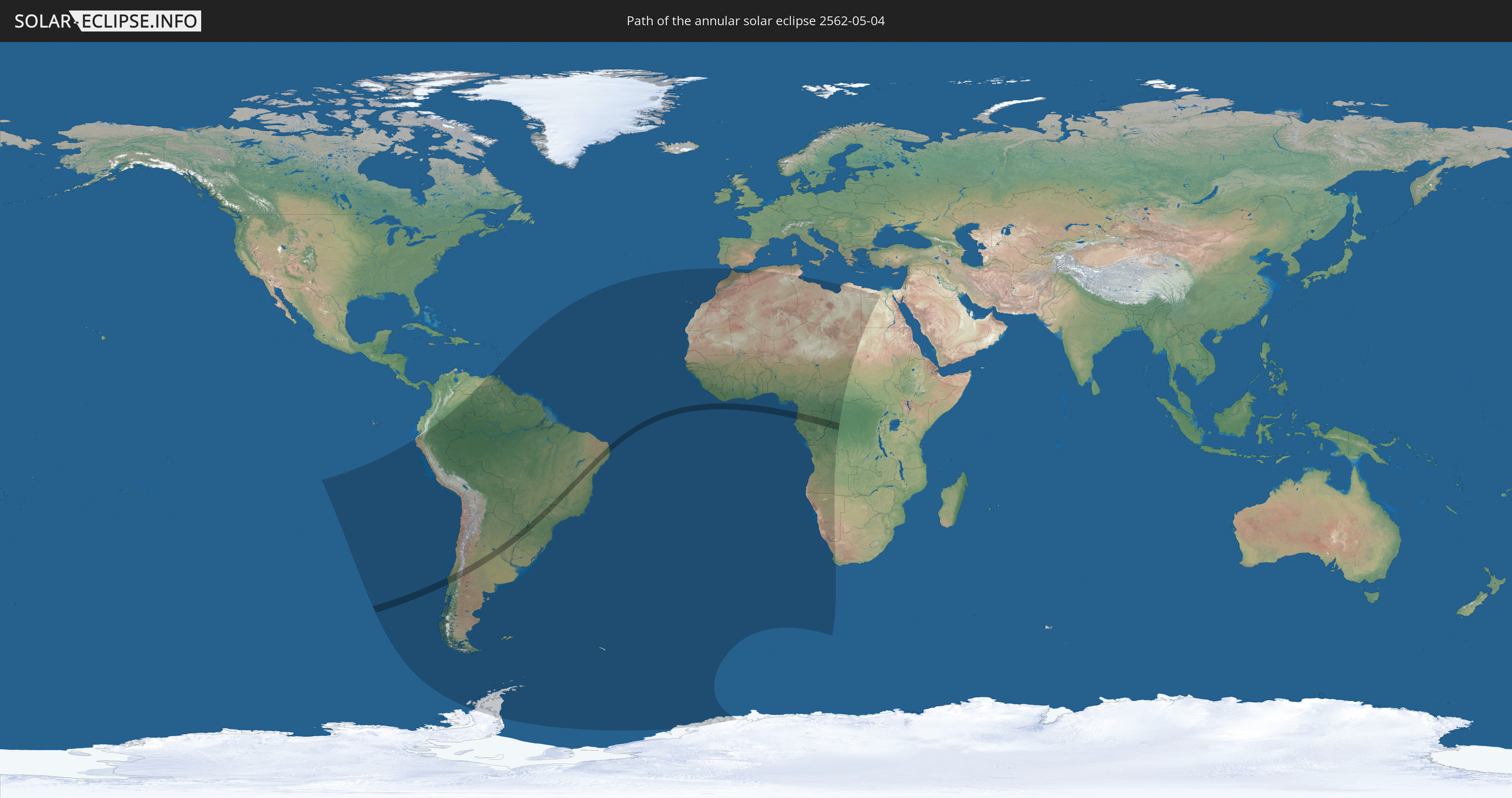
Annular solar eclipse of 05/04/2562
| Day of week: | Tuesday |
| Maximum duration of eclipse: | 03m35s |
| Maximum width of eclipse path: | 123 km |
| Saros cycle: | 147 |
| Coverage: | 96.9% |
| Magnitude: | 0.9686 |
| Gamma: | -0.4133 |
Wo kann man die Sonnenfinsternis vom 05/04/2562 sehen?
Die Sonnenfinsternis am 05/04/2562 kann man in 56 Ländern als partielle Sonnenfinsternis beobachten.
Der Finsternispfad verläuft durch 9 Länder. Nur in diesen Ländern ist sie als annular Sonnenfinsternis zu sehen.
In den folgenden Ländern ist die Sonnenfinsternis annular zu sehen
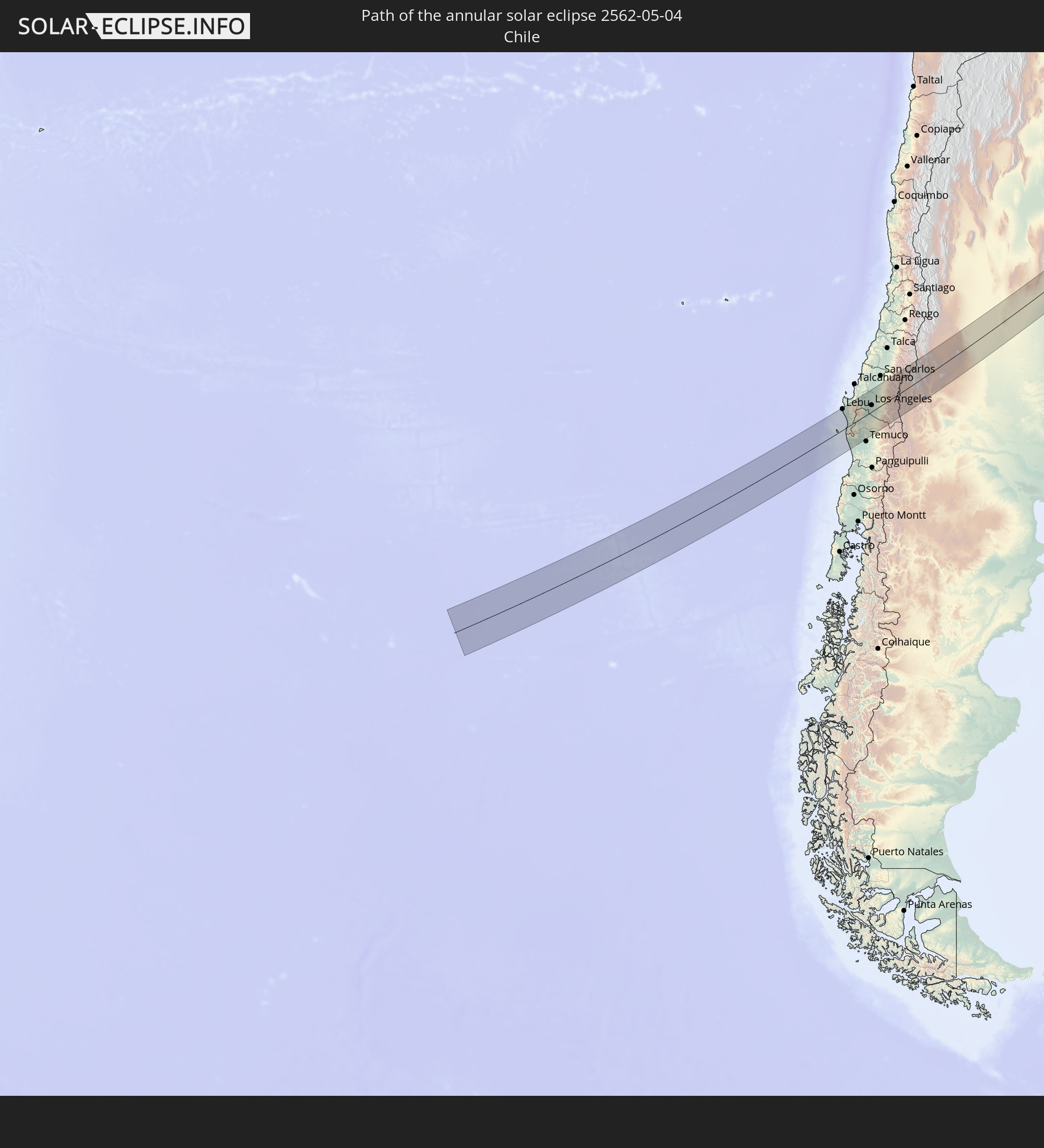 Chile
Chile
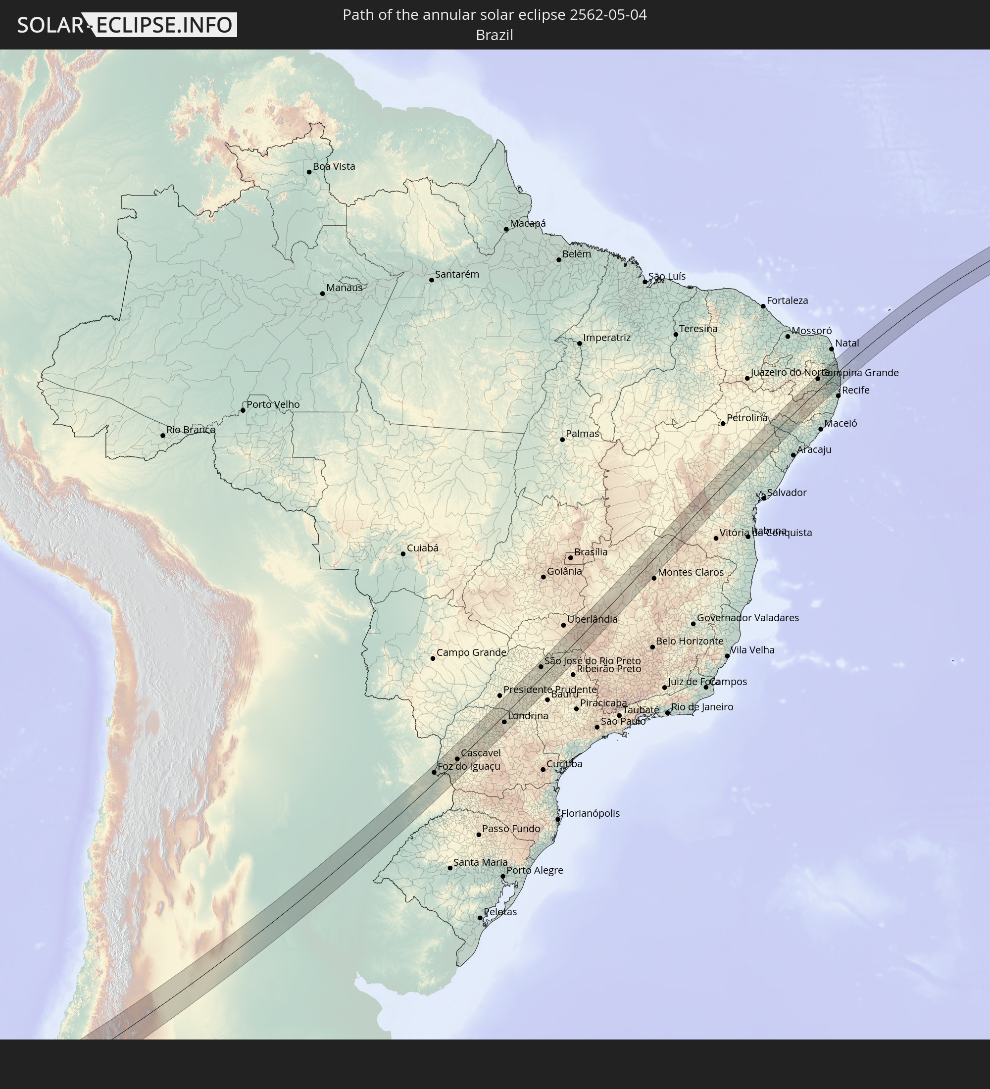 Brazil
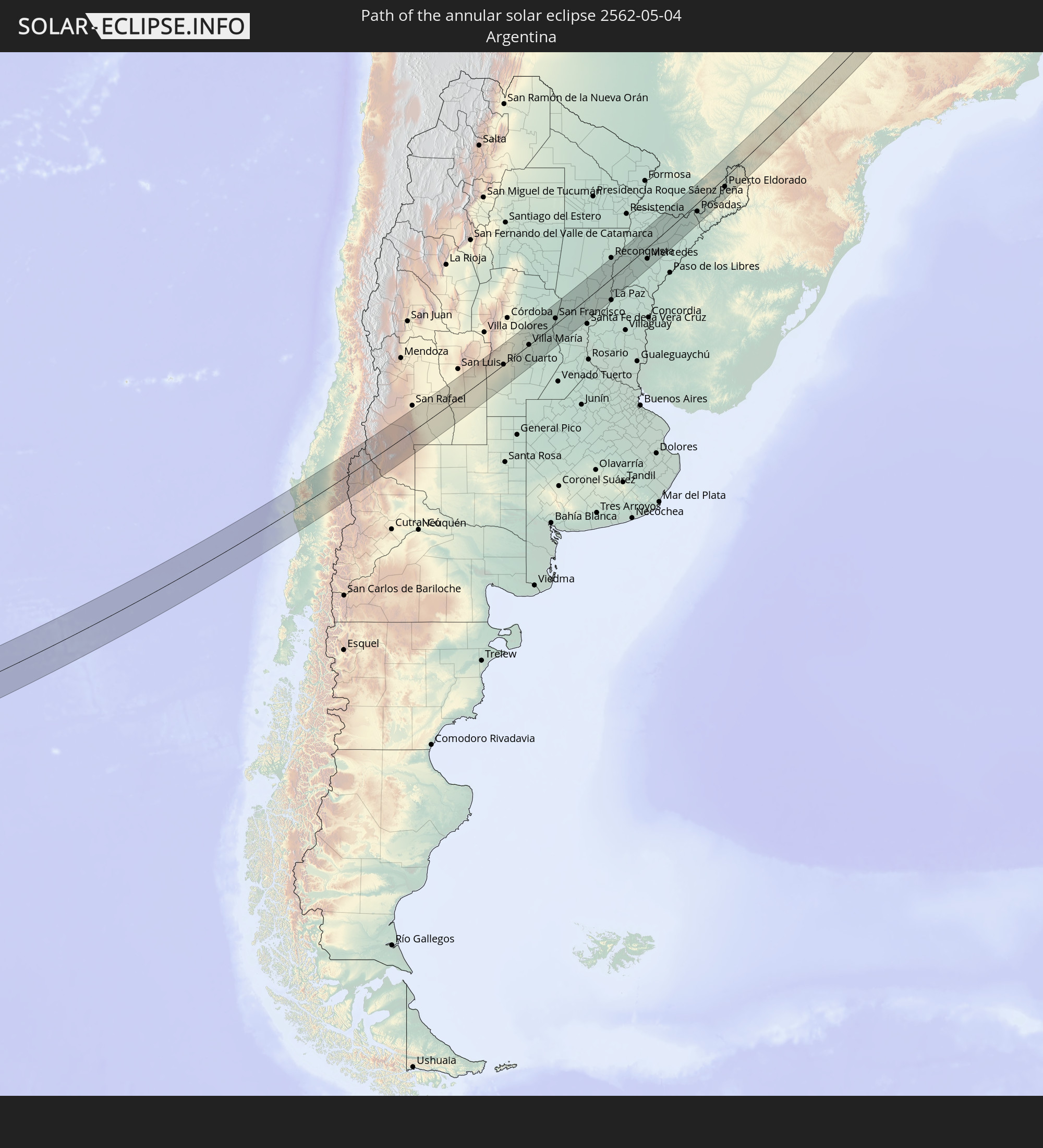 Argentina
 Paraguay
 Equatorial Guinea
 São Tomé and Príncipe
 Gabon
Gabon
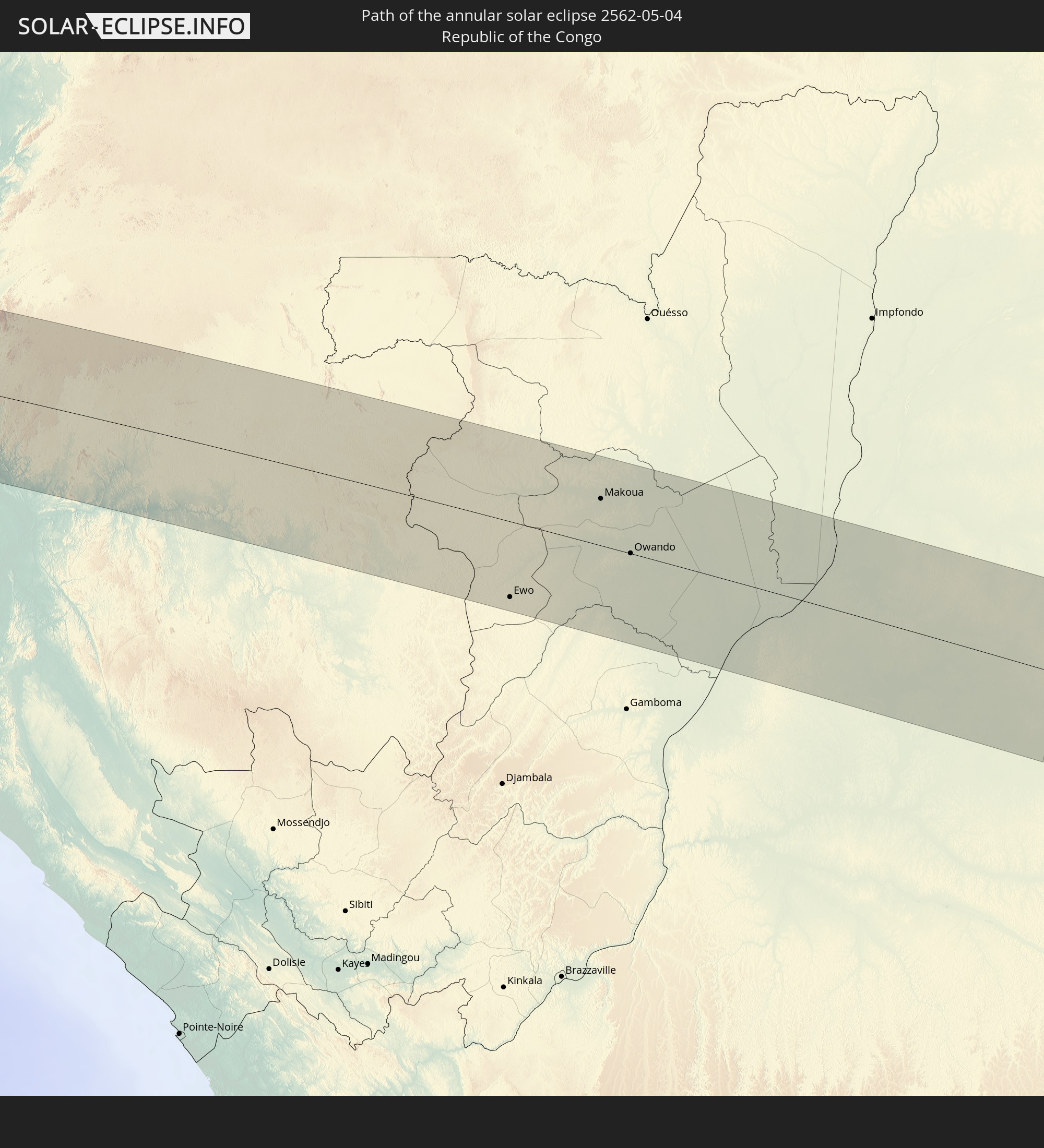 Republic of the Congo
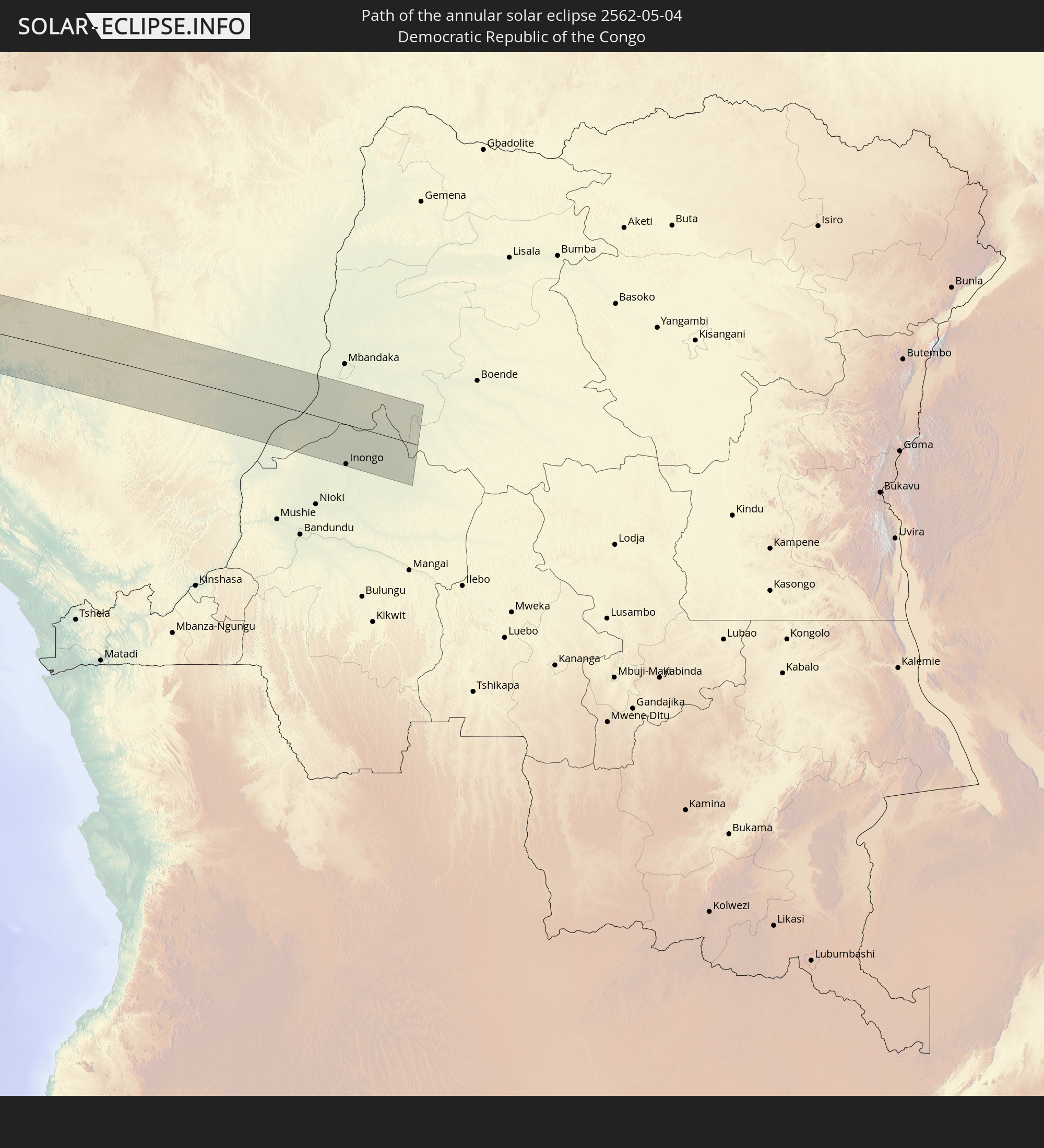 Democratic Republic of the Congo
In den folgenden Ländern ist die Sonnenfinsternis partiell zu sehen
 Antarctica
 Chile
Chile
 Ecuador
 Colombia
 Peru
Peru
 Brazil
 Argentina
 Venezuela
 Bolivia
 Paraguay
 Trinidad and Tobago
 Grenada
 Saint Vincent and the Grenadines
 Falkland Islands
 Guyana
 Barbados
 Uruguay
 Suriname
 French Guiana
 South Georgia and the South Sandwich Islands
 Portugal
 Cabo Verde
 Spain
Spain
 Senegal
 Mauritania
 The Gambia
 Guinea-Bissau
 Guinea
 Saint Helena, Ascension and Tristan da Cunha
 Sierra Leone
 Morocco
 Mali
Mali
 Liberia
 Algeria
 Ivory Coast
 Burkina Faso
 Ghana
Ghana
 Togo
Togo
 Niger
Niger
 Benin
Benin
 Nigeria
 Equatorial Guinea
 São Tomé and Príncipe
 Tunisia
 Cameroon
 Gabon
Gabon
 Libya
Libya
 Republic of the Congo
 Angola
 Namibia
 Democratic Republic of the Congo
 Chad
Chad
 Central African Republic
 South Africa
 Sudan
Sudan
 Egypt
Egypt
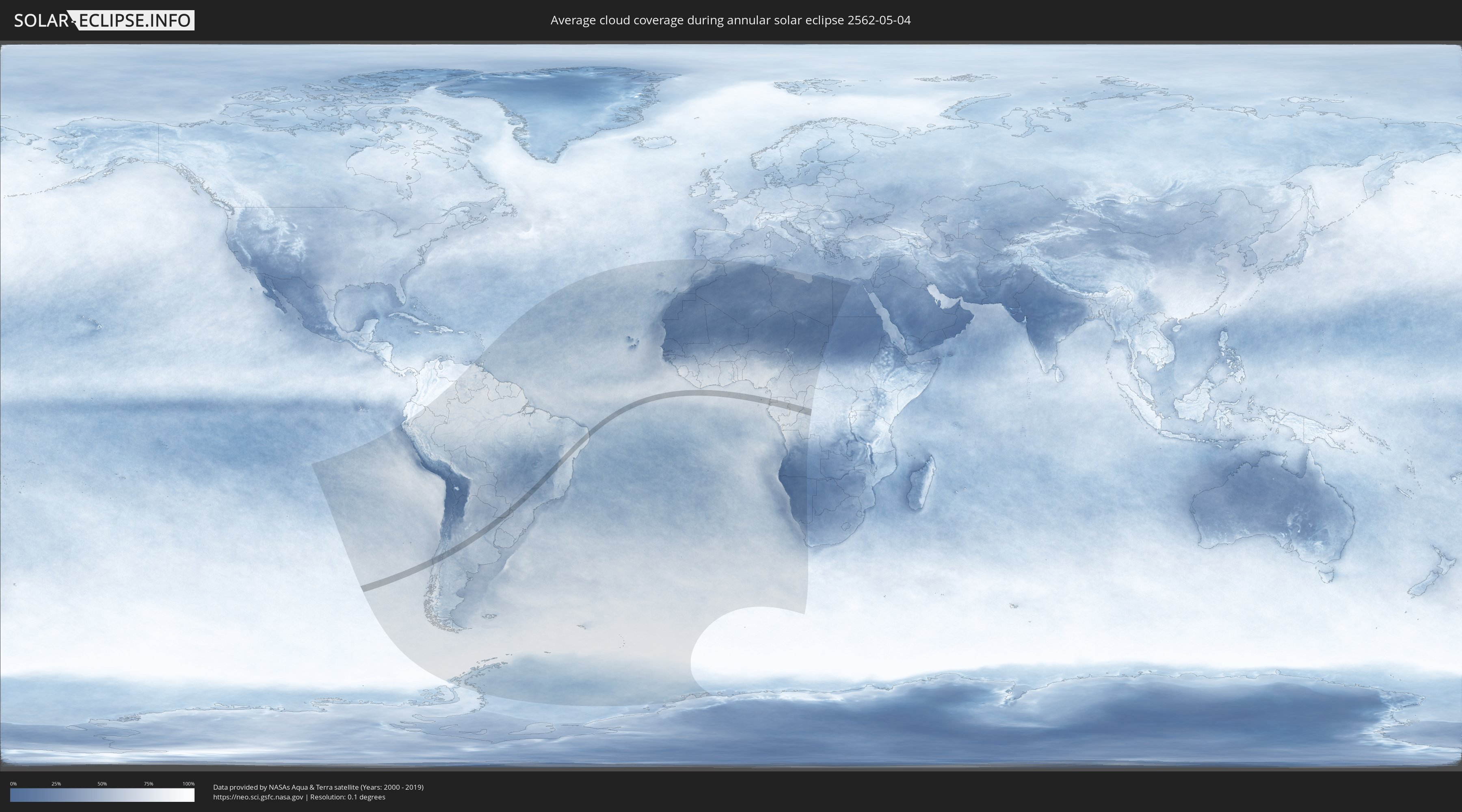
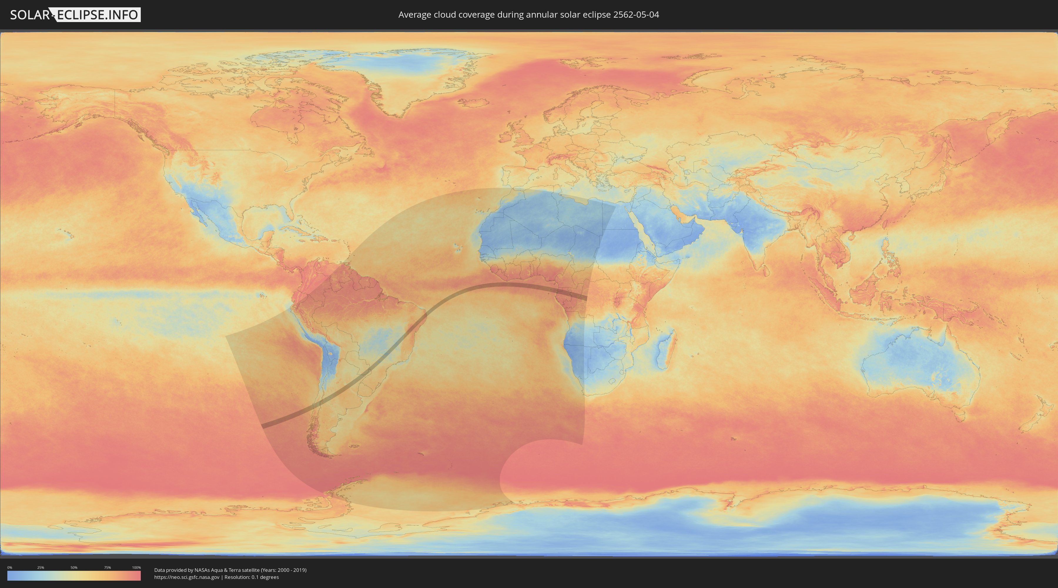
How will be the weather during the annular solar eclipse on 05/04/2562?
Where is the best place to see the annular solar eclipse of 05/04/2562?
The following maps show the average cloud coverage for the day of the annular solar eclipse.
With the help of these maps, it is possible to find the place along the eclipse path, which has the best
chance of a cloudless sky.
Nevertheless, you should consider local circumstances and inform about the weather of your chosen
observation site.
The data is provided by NASAs satellites
AQUA and TERRA.
The cloud maps are averaged over a period of 19 years (2000 - 2019).
Detailed country maps
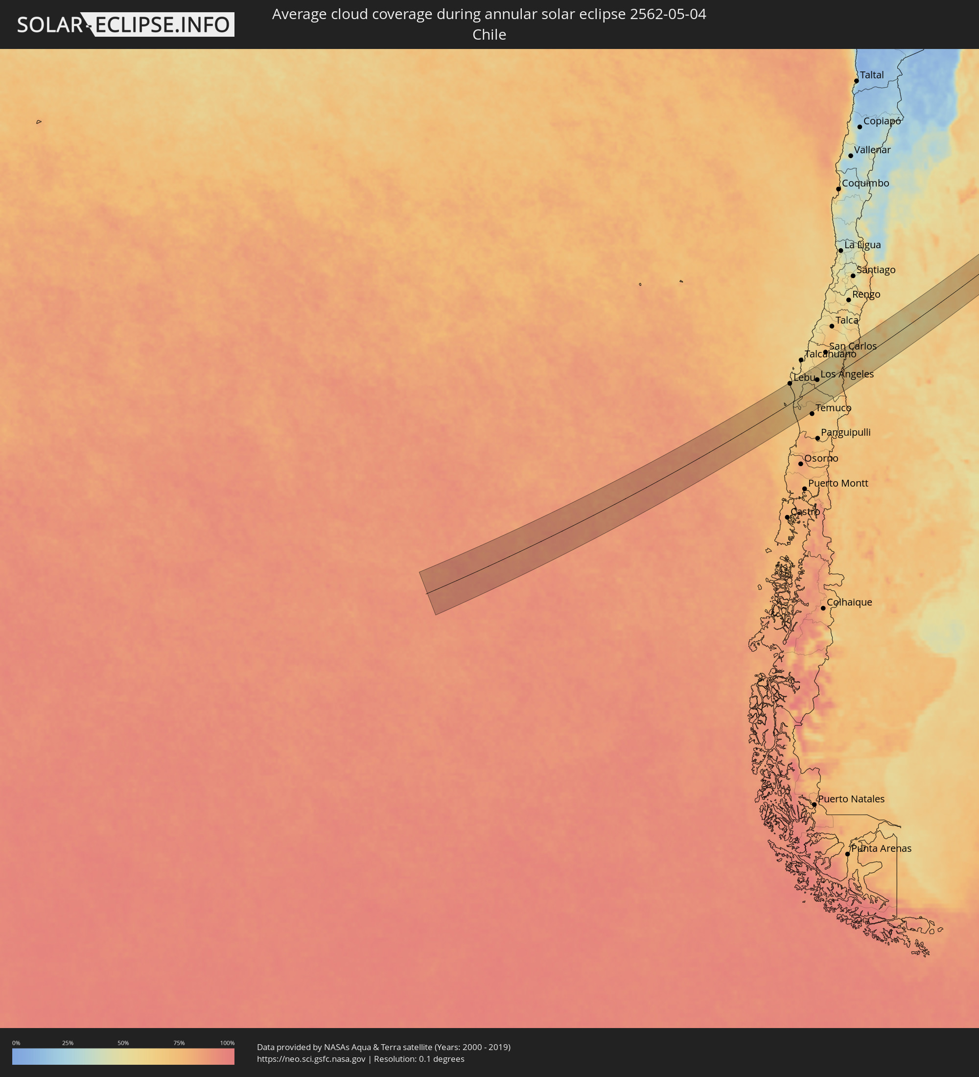 Chile
Chile
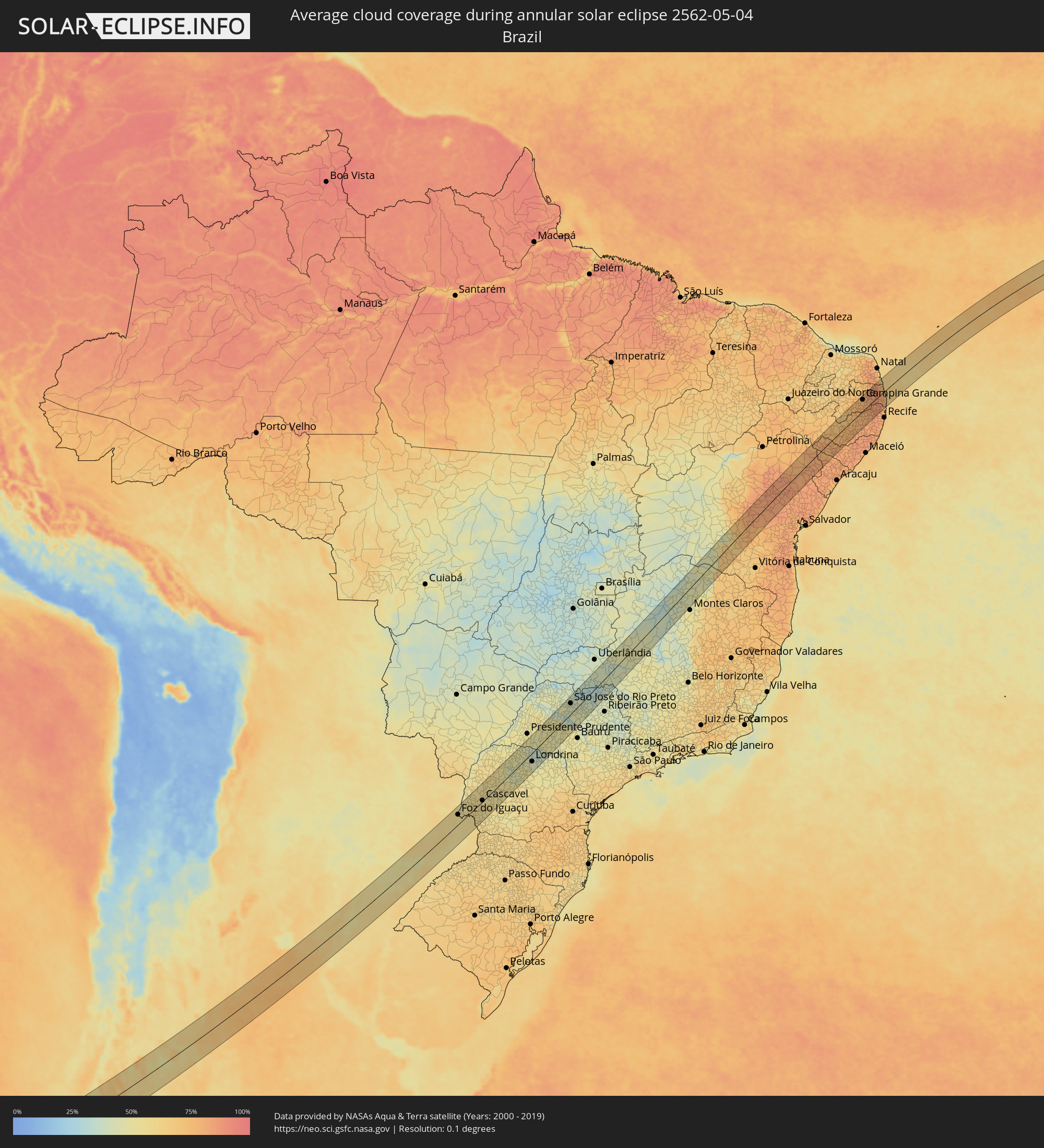 Brazil
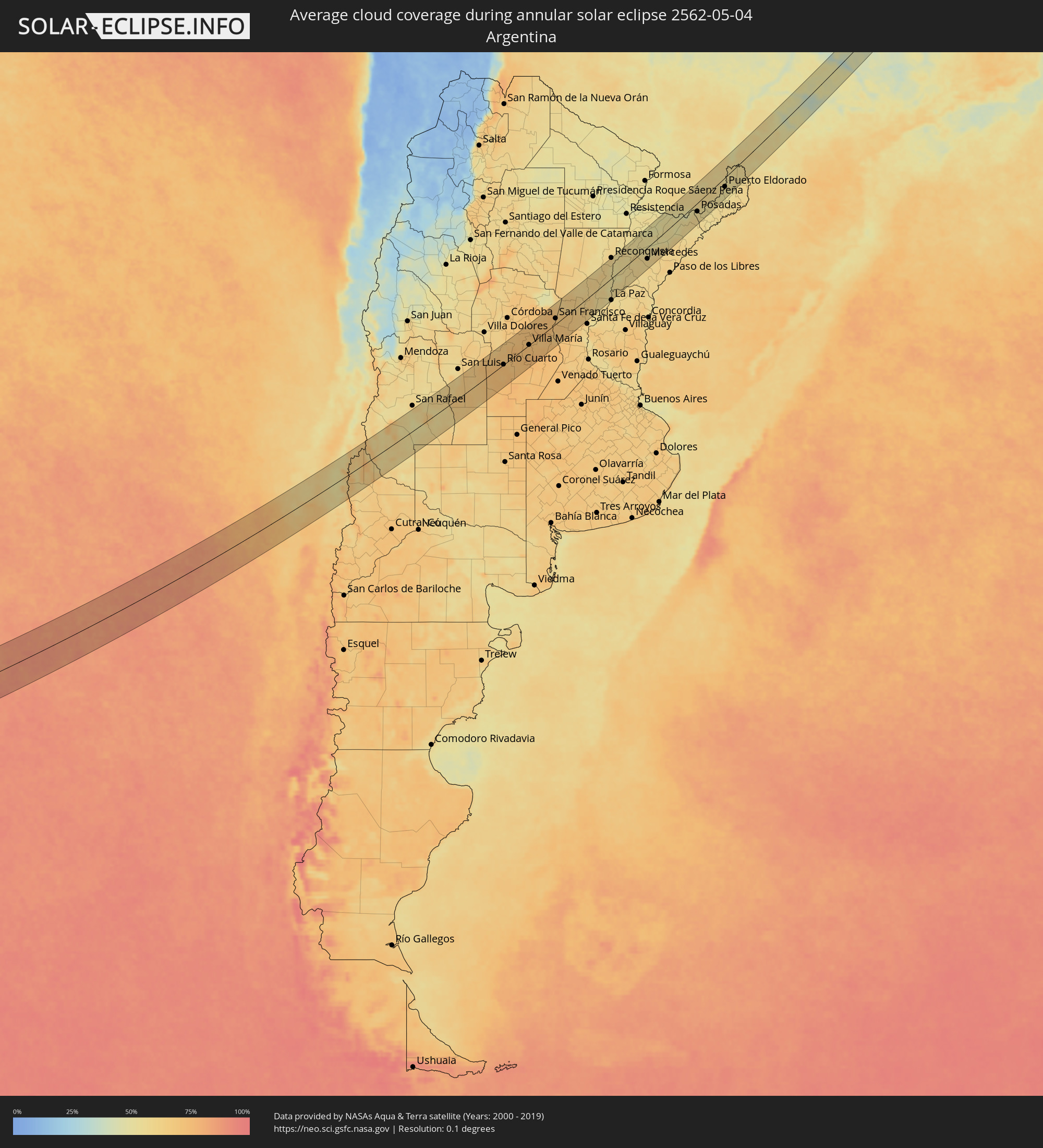 Argentina
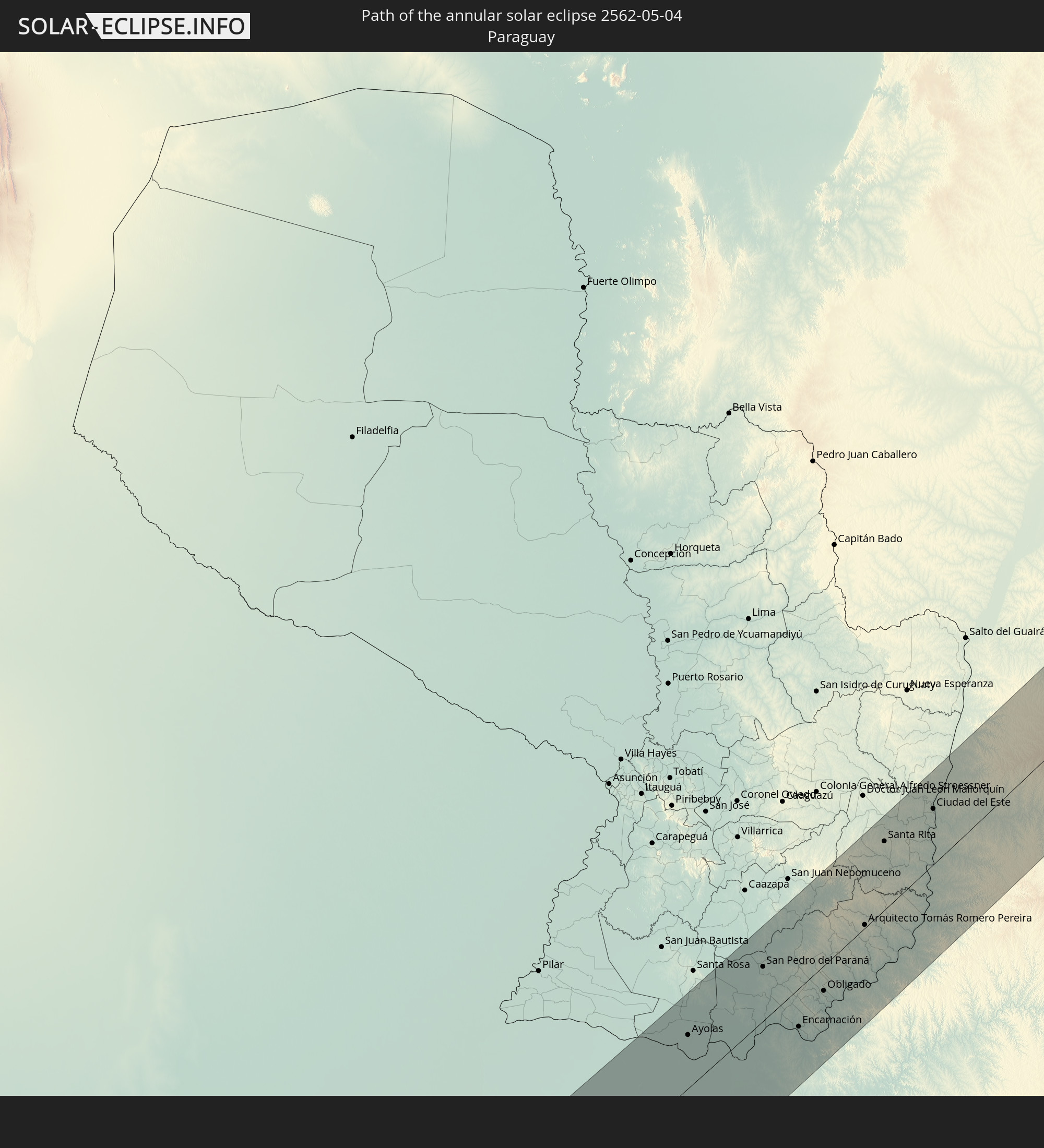
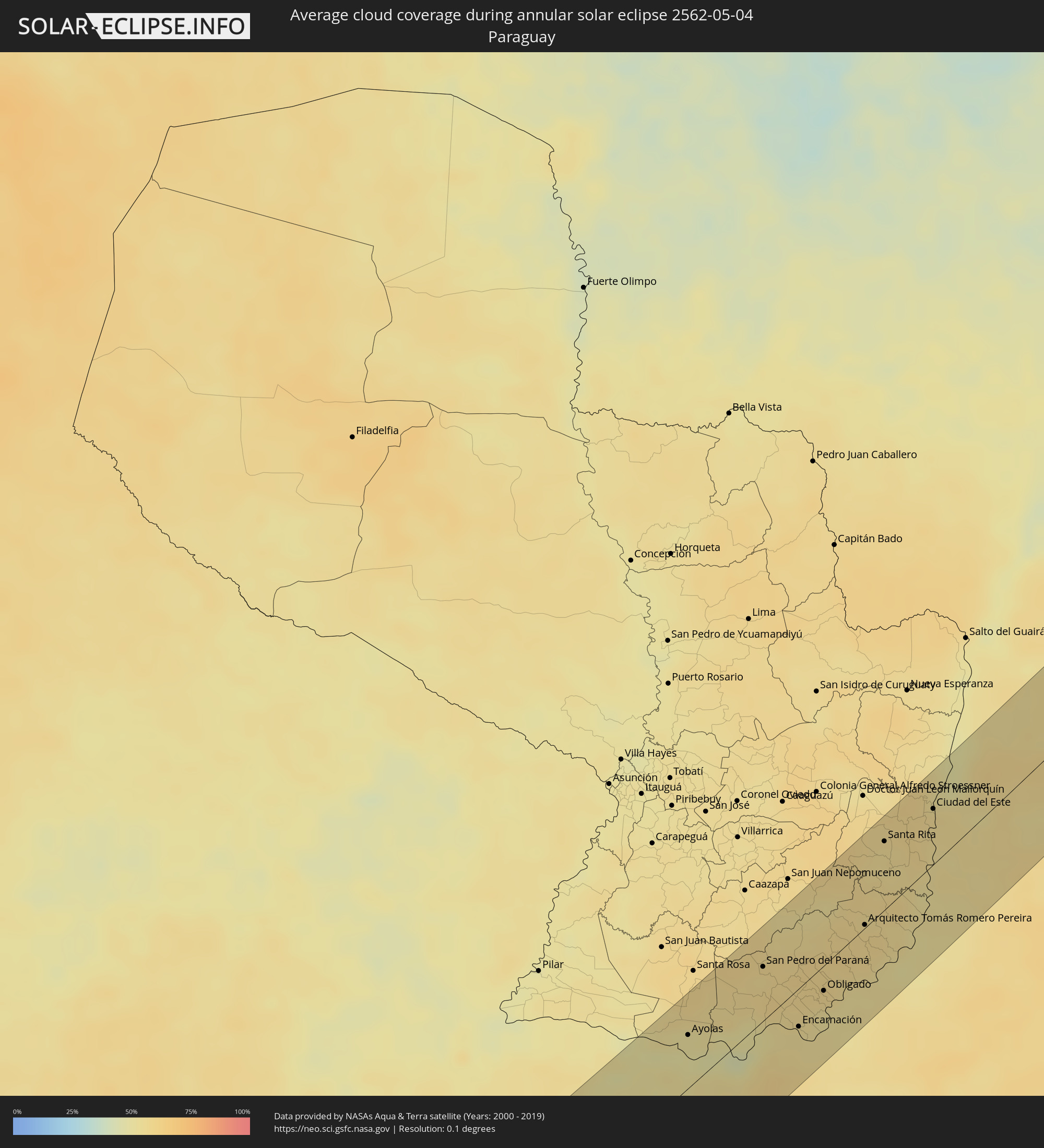 Paraguay
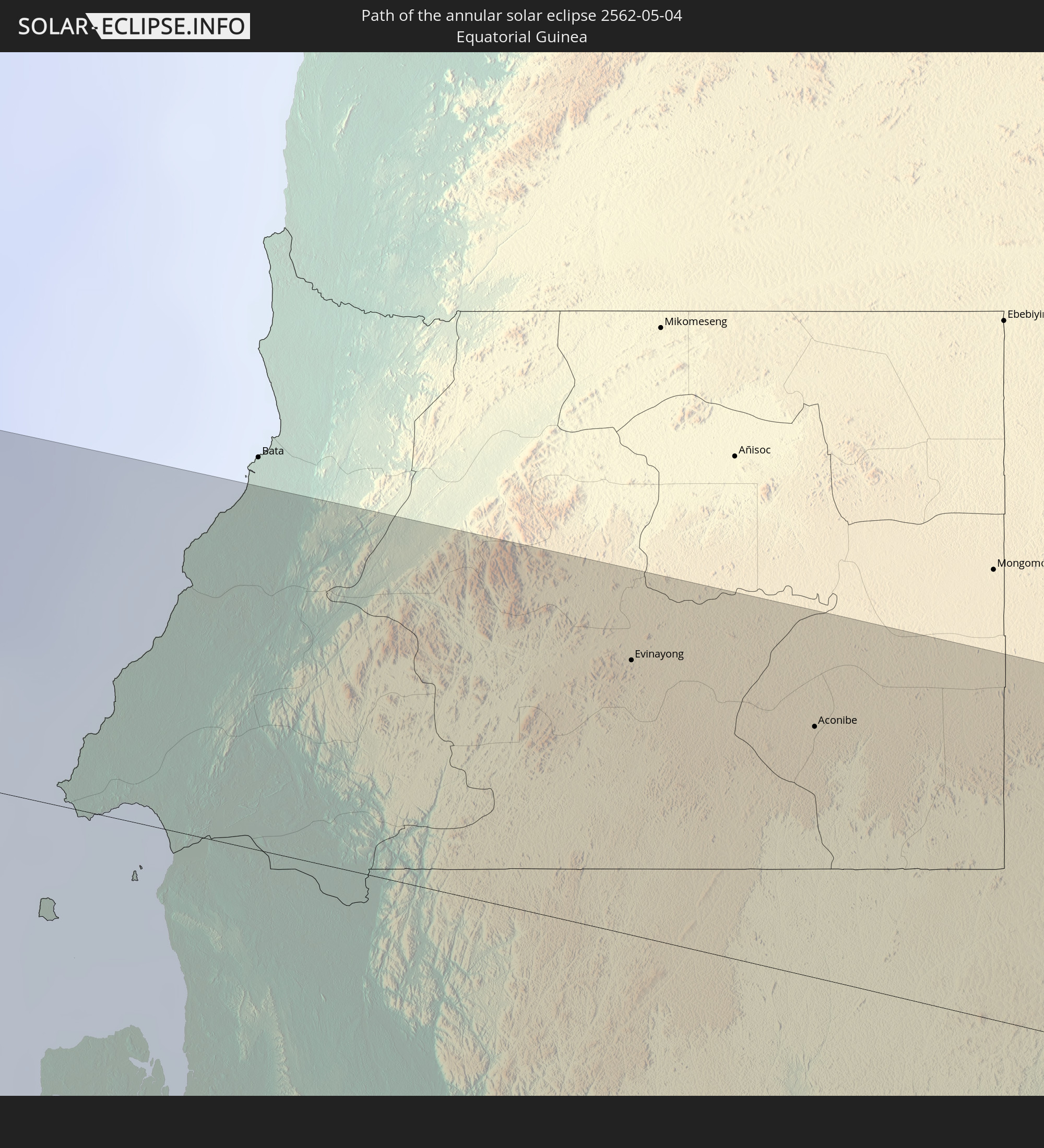
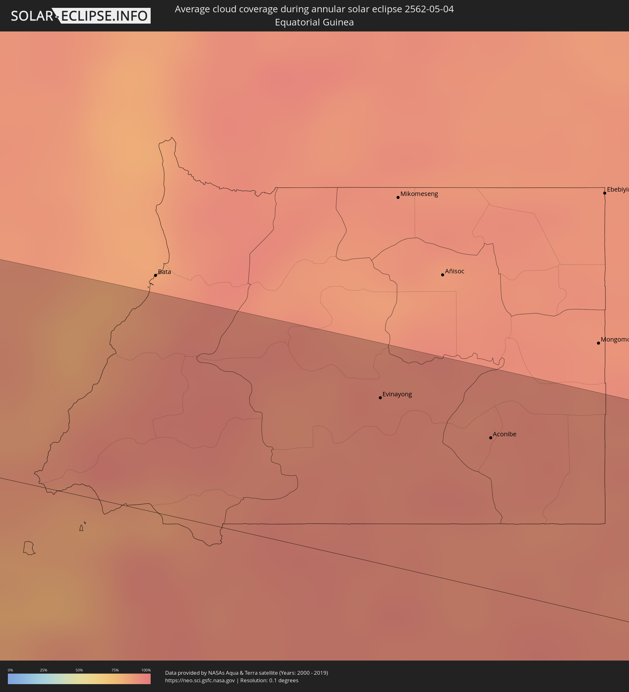 Equatorial Guinea
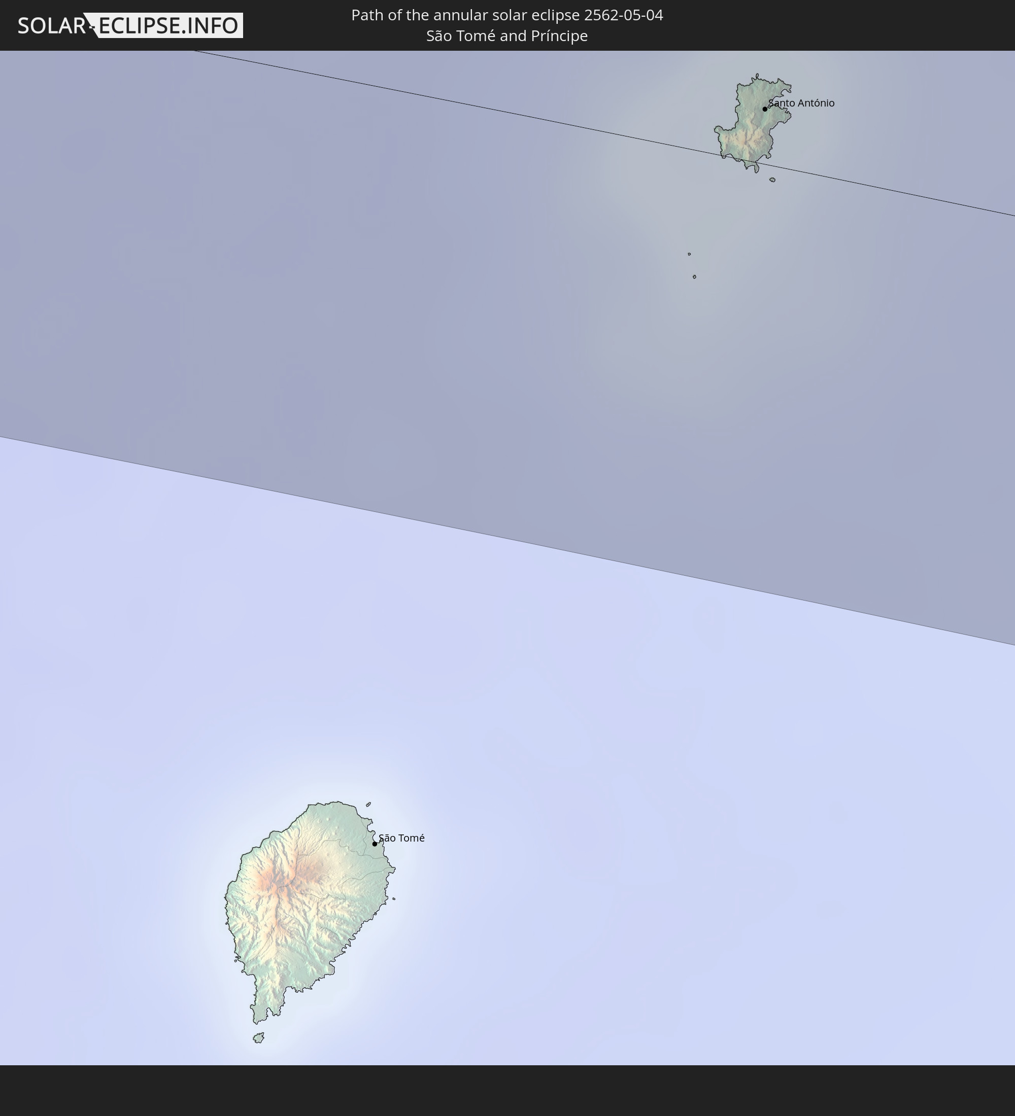
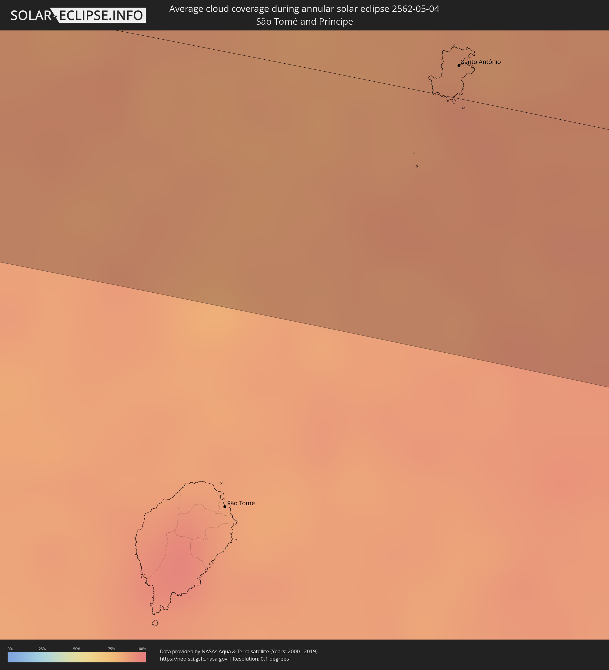 São Tomé and Príncipe
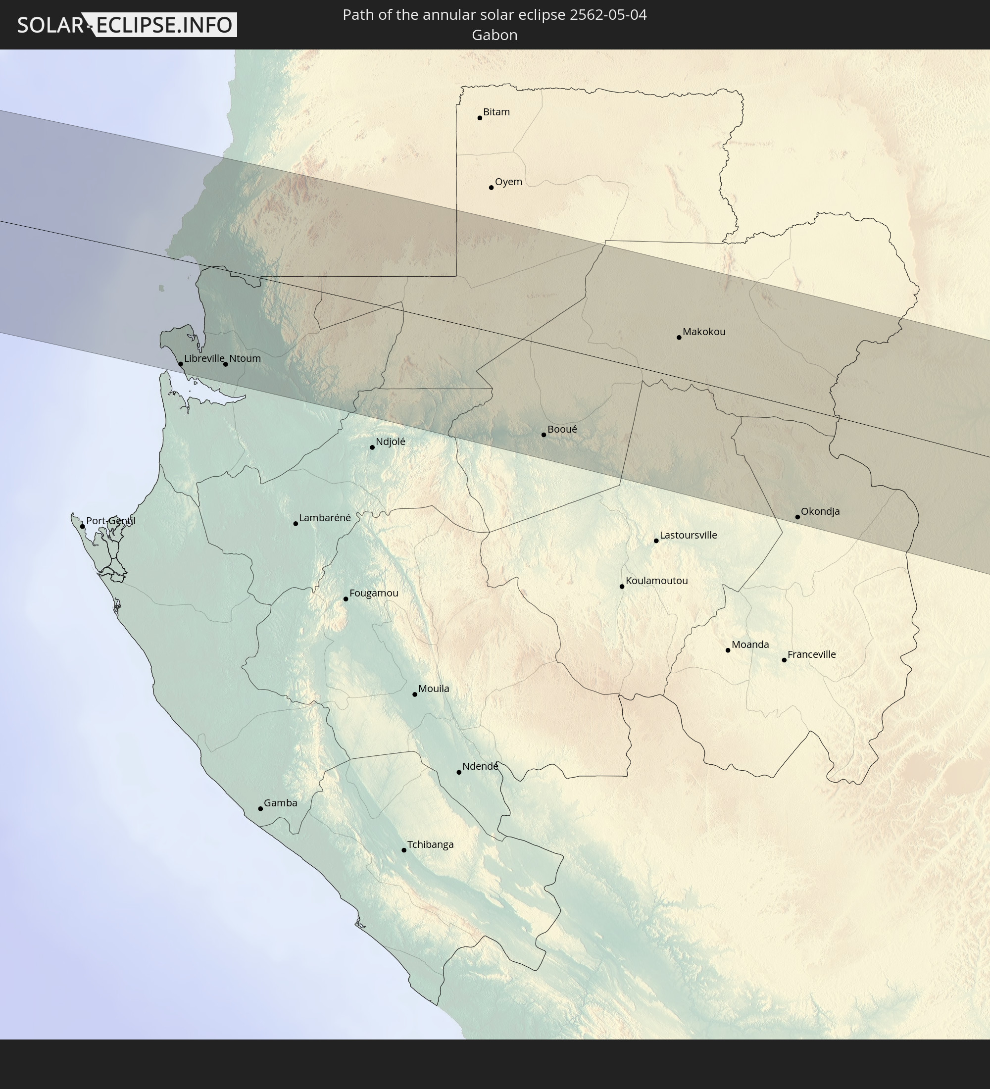
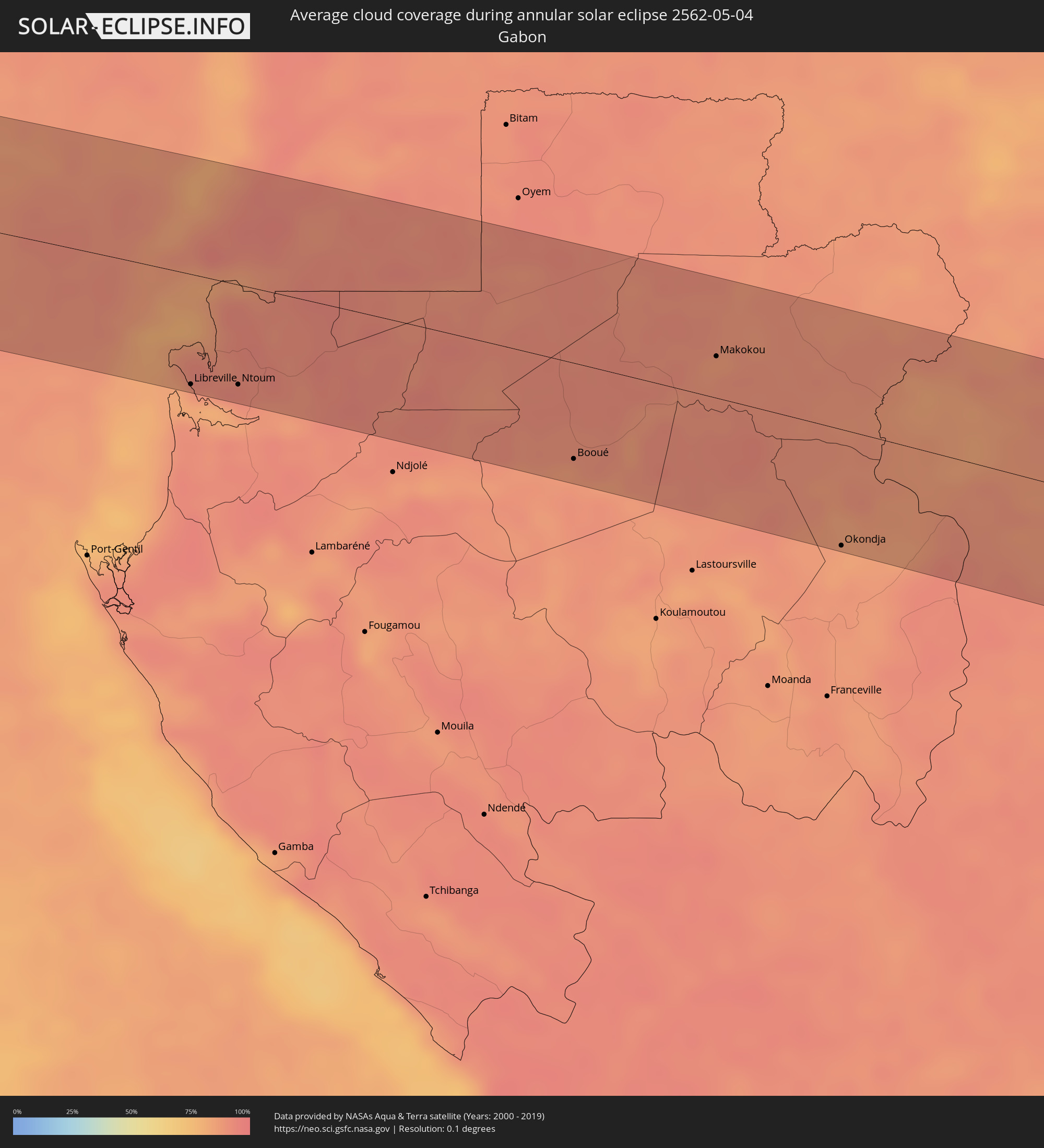 Gabon
Gabon
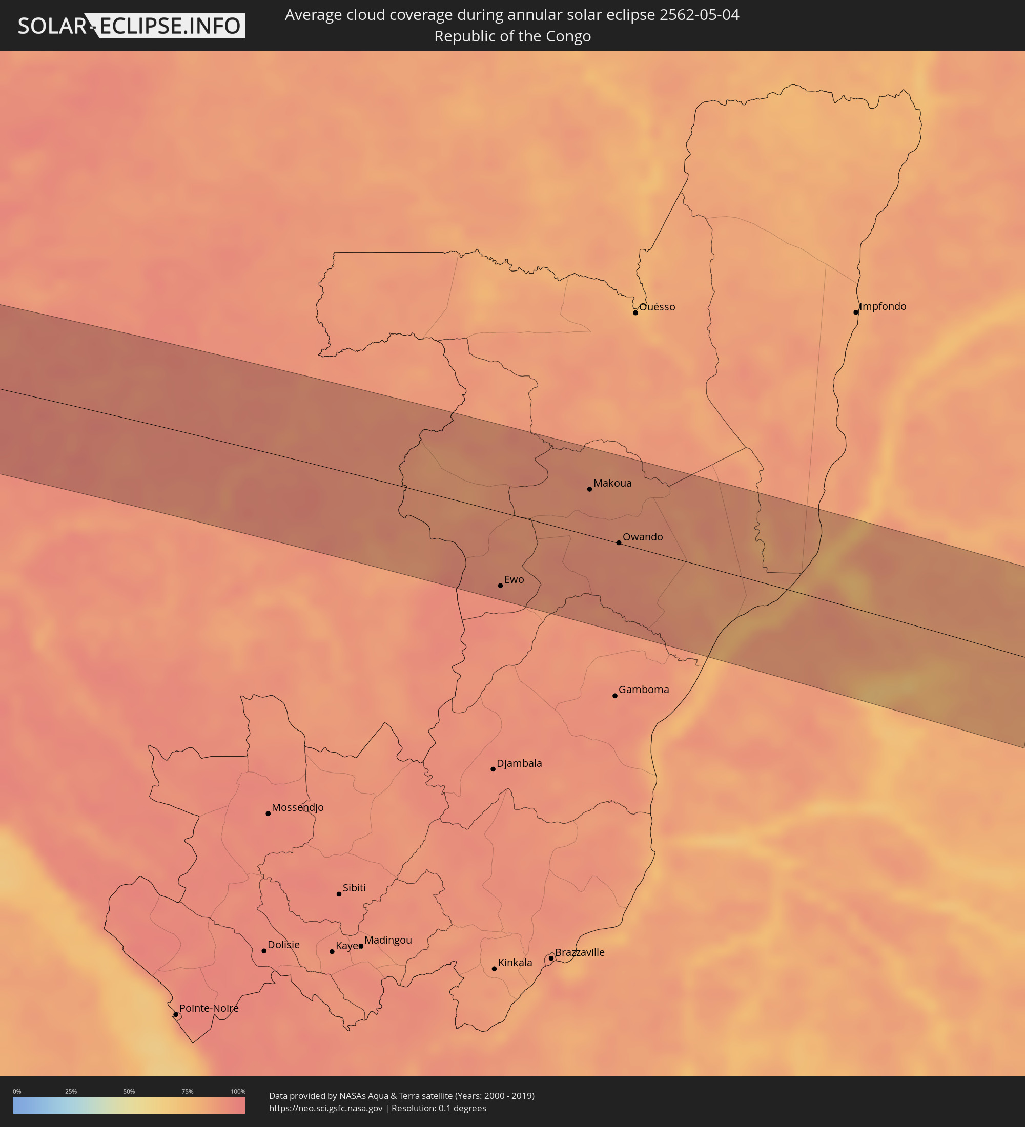 Republic of the Congo
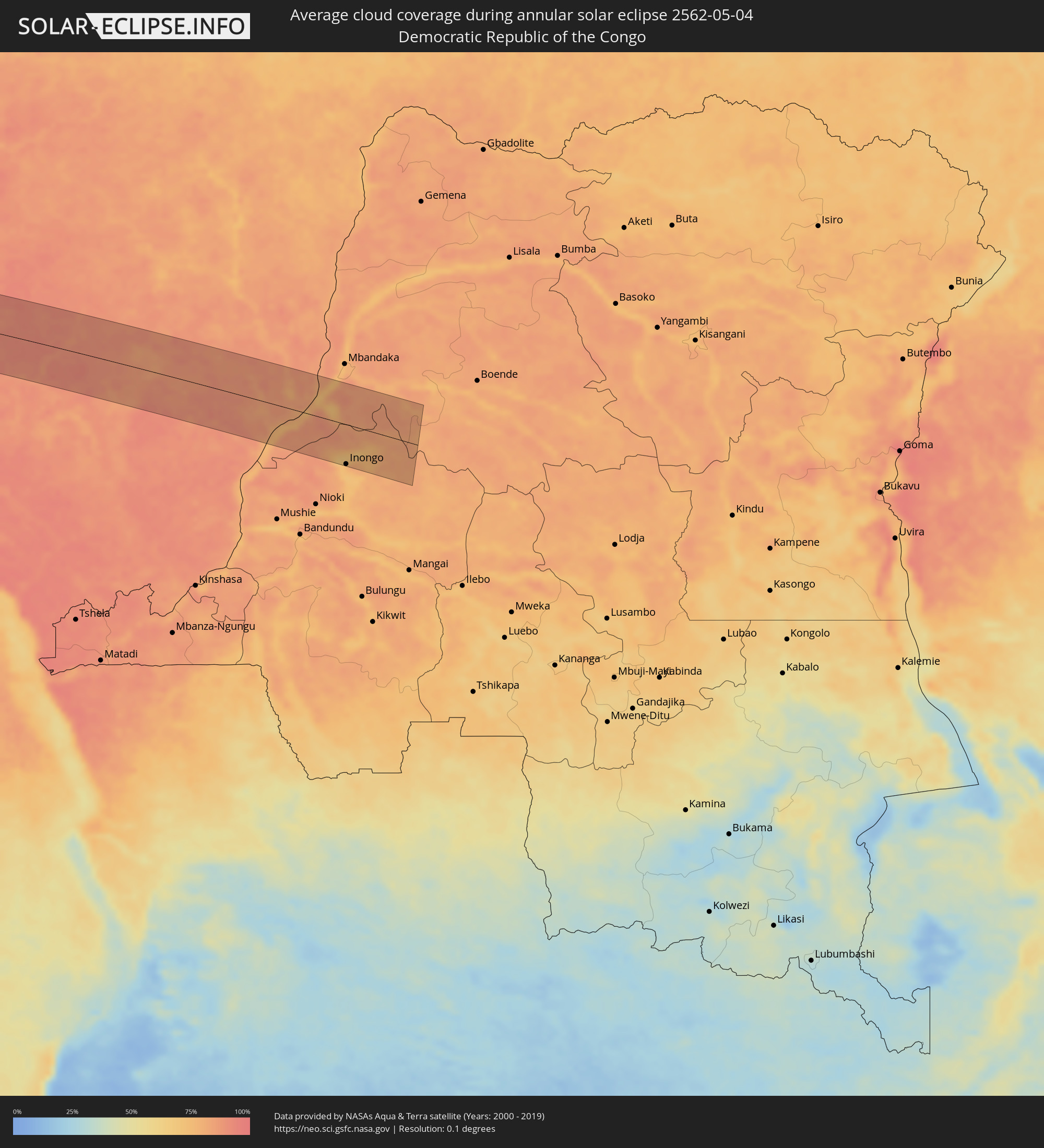 Democratic Republic of the Congo
Cities inside the path of the eclipse
The following table shows all locations with a population of more than 5,000 inside the eclipse path. Cities which have more than 100,000 inhabitants are marked bold. A click at the locations opens a detailed map.
| City | Type | Eclipse duration | Local time of max. eclipse | Distance to central line | Ø Cloud coverage |
|
Lebu, Biobío
|
annular | - | 10:12:52 UTC-03:00 | 69 km | 62% |
|
Cañete, Biobío
|
annular | - | 10:13:03 UTC-03:00 | 39 km | 61% |
|
Curanilahue, Biobío
|
annular | - | 10:13:04 UTC-03:00 | 67 km | 59% |
|
Carahue, Araucanía
|
annular | - | 10:13:18 UTC-03:00 | 57 km | 70% |
|
Nueva Imperial, Araucanía
|
annular | - | 10:13:27 UTC-03:00 | 70 km | 72% |
|
Angol, Araucanía
|
annular | - | 10:13:31 UTC-03:00 | 8 km | 64% |
|
La Laja, Biobío
|
annular | - | 10:13:29 UTC-03:00 | 56 km | 58% |
|
Nacimiento, Biobío
|
annular | - | 10:13:31 UTC-03:00 | 33 km | 60% |
|
Traiguén, Araucanía
|
annular | - | 10:13:35 UTC-03:00 | 37 km | 66% |
|
Yumbel, Biobío
|
annular | - | 10:13:35 UTC-03:00 | 66 km | 60% |
|
Lautaro, Araucanía
|
annular | - | 10:13:46 UTC-03:00 | 74 km | 68% |
|
Collipulli, Araucanía
|
annular | - | 10:13:43 UTC-03:00 | 20 km | 62% |
|
Cabrero, Biobío
|
annular | - | 10:13:41 UTC-03:00 | 64 km | 62% |
|
Los Ángeles, Biobío
|
annular | - | 10:13:44 UTC-03:00 | 21 km | 63% |
|
Victoria, Araucanía
|
annular | - | 10:13:48 UTC-03:00 | 51 km | 67% |
|
Mulchén, Biobío
|
annular | - | 10:13:50 UTC-03:00 | 8 km | 56% |
|
Coihueco, Biobío
|
annular | - | 10:14:05 UTC-03:00 | 75 km | 57% |
|
Villa Mercedes, San Luis Province
|
annular | - | 10:19:47 UTC-03:00 | 14 km | 67% |
|
Río Cuarto, Cordoba Province
|
annular | - | 10:21:02 UTC-03:00 | 0 km | 72% |
|
Villa María, Cordoba Province
|
annular | - | 10:22:25 UTC-03:00 | 1 km | 72% |
|
Las Varillas, Cordoba Province
|
annular | - | 10:23:11 UTC-03:00 | 17 km | 73% |
|
Bell Ville, Cordoba Province
|
annular | - | 10:22:55 UTC-03:00 | 50 km | 74% |
|
San Francisco, Cordoba Province
|
annular | - | 10:24:04 UTC-03:00 | 19 km | 70% |
|
San Jorge, Santa Fe Province
|
annular | - | 10:24:06 UTC-03:00 | 35 km | 71% |
|
Sunchales, Santa Fe Province
|
annular | - | 10:24:52 UTC-03:00 | 29 km | 64% |
|
Rafaela, Santa Fe Province
|
annular | - | 10:24:49 UTC-03:00 | 2 km | 67% |
|
Esperanza, Santa Fe Province
|
annular | - | 10:25:21 UTC-03:00 | 52 km | 65% |
|
San Justo, Santa Fe Province
|
annular | - | 10:26:04 UTC-03:00 | 16 km | 63% |
|
San Javier, Santa Fe Province
|
annular | - | 10:26:57 UTC-03:00 | 38 km | 55% |
|
Reconquista, Santa Fe Province
|
annular | - | 10:28:08 UTC-03:00 | 66 km | 59% |
|
Esquina, Corrientes Province
|
annular | - | 10:27:46 UTC-03:00 | 15 km | 53% |
|
Goya, Corrientes Province
|
annular | - | 10:28:37 UTC-03:00 | 43 km | 56% |
|
Mercedes, Corrientes Province
|
annular | - | 10:30:06 UTC-03:00 | 36 km | 58% |
|
Ayolas, Misiones
|
annular | - | 10:32:57 UTC-03:00 | 37 km | 49% |
|
San Pedro del Paraná, Itapúa
|
annular | - | 10:34:23 UTC-03:00 | 37 km | 55% |
|
Posadas, Misiones Province
|
annular | - | 10:34:22 UTC-03:00 | 27 km | 55% |
|
Encarnación, Itapúa
|
annular | - | 10:34:27 UTC-03:00 | 26 km | 54% |
|
Hohenau, Itapúa
|
annular | - | 10:34:49 UTC-03:00 | 14 km | 56% |
|
Obligado, Itapúa
|
annular | - | 10:35:01 UTC-03:00 | 17 km | 57% |
|
Arquitecto Tomás Romero Pereira, Itapúa
|
annular | - | 10:36:03 UTC-03:00 | 2 km | 58% |
|
Jardín América, Misiones Province
|
annular | - | 10:35:36 UTC-03:00 | 45 km | 52% |
|
Santa Rita, Alto Paraná
|
annular | - | 10:36:57 UTC-03:00 | 47 km | 55% |
|
Puerto Rico, Misiones Province
|
annular | - | 10:36:06 UTC-03:00 | 39 km | 52% |
|
Montecarlo, Misiones Province
|
annular | - | 10:36:41 UTC-03:00 | 38 km | 52% |
|
Puerto Eldorado, Misiones Province
|
annular | - | 10:36:55 UTC-03:00 | 29 km | 53% |
|
Puerto Esperanza, Misiones Province
|
annular | - | 10:37:19 UTC-03:00 | 1 km | 54% |
|
Presidente Franco, Alto Paraná
|
annular | - | 10:37:51 UTC-03:00 | 36 km | 56% |
|
Ciudad del Este, Alto Paraná
|
annular | - | 10:37:53 UTC-03:00 | 38 km | 56% |
|
Foz do Iguaçu, Paraná
|
annular | - | 10:37:53 UTC-03:00 | 33 km | 56% |
|
Puerto Iguazú, Misiones Province
|
annular | - | 10:37:51 UTC-03:00 | 28 km | 55% |
|
Toledo, Paraná
|
annular | - | 10:39:59 UTC-03:00 | 42 km | 56% |
|
Cascavel, Paraná
|
annular | - | 10:40:11 UTC-03:00 | 3 km | 58% |
|
Campo Mourão, Paraná
|
annular | - | 10:42:51 UTC-03:00 | 0 km | 49% |
|
Maringá, Paraná
|
annular | - | 10:44:16 UTC-03:00 | 18 km | 46% |
|
Apucarana, Paraná
|
annular | - | 10:44:55 UTC-03:00 | 26 km | 49% |
|
Arapongas, Paraná
|
annular | - | 10:45:07 UTC-03:00 | 18 km | 46% |
|
Londrina, Paraná
|
annular | - | 10:45:41 UTC-03:00 | 29 km | 44% |
|
Assis, São Paulo
|
annular | - | 10:47:45 UTC-03:00 | 32 km | 44% |
|
Marília, São Paulo
|
annular | - | 10:49:07 UTC-03:00 | 31 km | 50% |
|
São José do Rio Preto, São Paulo
|
annular | - | 10:51:57 UTC-03:00 | 36 km | 42% |
|
Catanduva, São Paulo
|
annular | - | 10:52:15 UTC-03:00 | 19 km | 44% |
|
Barretos, São Paulo
|
annular | - | 10:53:48 UTC-03:00 | 5 km | 38% |
|
Uberaba, Minas Gerais
|
annular | - | 10:56:09 UTC-03:00 | 10 km | 43% |
|
Patrocínio, Minas Gerais
|
annular | - | 10:59:09 UTC-03:00 | 0 km | 44% |
|
Araxá, Minas Gerais
|
annular | - | 10:58:17 UTC-03:00 | 54 km | 45% |
|
Patos de Minas, Minas Gerais
|
annular | - | 11:00:39 UTC-03:00 | 8 km | 46% |
|
Paulo Afonso, Bahia
|
annular | - | 11:36:33 UTC-03:00 | 46 km | 77% |
|
Garanhuns, Pernambuco
|
annular | - | 11:42:07 UTC-03:00 | 44 km | 79% |
|
Santa Cruz do Capibaribe, Pernambuco
|
annular | - | 11:44:52 UTC-03:00 | 8 km | 79% |
|
Caruaru, Pernambuco
|
annular | - | 11:44:47 UTC-03:00 | 36 km | 78% |
|
Campina Grande, Paraíba
|
annular | - | 11:47:16 UTC-03:00 | 43 km | 78% |
|
João Pessoa, Paraíba
|
annular | - | 11:50:16 UTC-03:00 | 23 km | 77% |
|
Santo António, Príncipe
|
annular | - | 16:33:18 UTC+00:00 | 11 km | 88% |
|
Libreville, Estuaire
|
annular | - | 17:33:54 UTC+01:00 | 78 km | 89% |
|
Ntoum, Estuaire
|
annular | - | 17:34:05 UTC+01:00 | 70 km | 93% |
|
Evinayong, Centro Sur
|
annular | - | 17:35:10 UTC+01:00 | 63 km | 92% |
|
Aconibe, Wele-Nzas
|
annular | - | 17:35:18 UTC+01:00 | 57 km | 91% |
|
Booué, Ogooué-Ivindo
|
annular | - | 17:35:00 UTC+01:00 | 67 km | 88% |
|
Makokou, Ogooué-Ivindo
|
annular | - | 17:35:51 UTC+01:00 | 29 km | 87% |
|
Okondja, Haut-Ogooué
|
annular | - | 17:35:28 UTC+01:00 | 81 km | 86% |
|
Ewo, Cuvette-Ouest
|
annular | - | 17:35:48 UTC+01:00 | 73 km | 92% |
|
Makoua, Cuvette
|
annular | - | 17:36:36 UTC+01:00 | 45 km | 90% |
|
Owando, Cuvette
|
annular | - | 17:36:24 UTC+01:00 | 0 km | 88% |
|
Lukolela, Équateur
|
annular | - | 17:36:27 UTC+01:00 | 24 km | 86% |
|
Inongo, Bandundu
|
annular | - | 17:36:12 UTC+01:00 | 84 km | 74% |