Total solar eclipse of 12/20/2587
| Day of week: | Thursday |
| Maximum duration of eclipse: | 03m22s |
| Maximum width of eclipse path: | 154 km |
| Saros cycle: | 151 |
| Coverage: | 100% |
| Magnitude: | 1.0428 |
| Gamma: | -0.3767 |
Wo kann man die Sonnenfinsternis vom 12/20/2587 sehen?
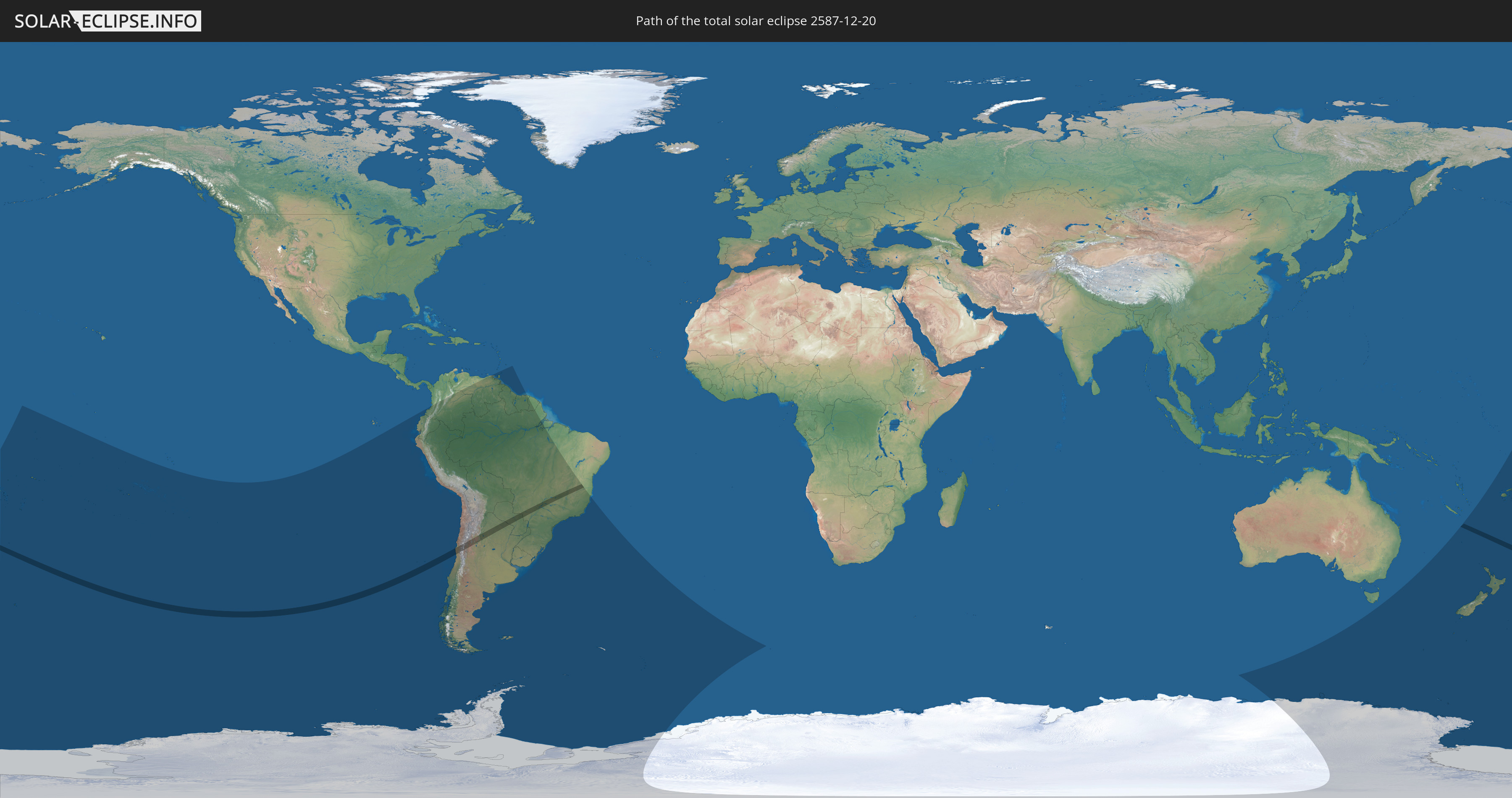
Die Sonnenfinsternis am 12/20/2587 kann man in 33 Ländern als partielle Sonnenfinsternis beobachten.
Der Finsternispfad verläuft durch 5 Länder. Nur in diesen Ländern ist sie als total Sonnenfinsternis zu sehen.
In den folgenden Ländern ist die Sonnenfinsternis total zu sehen
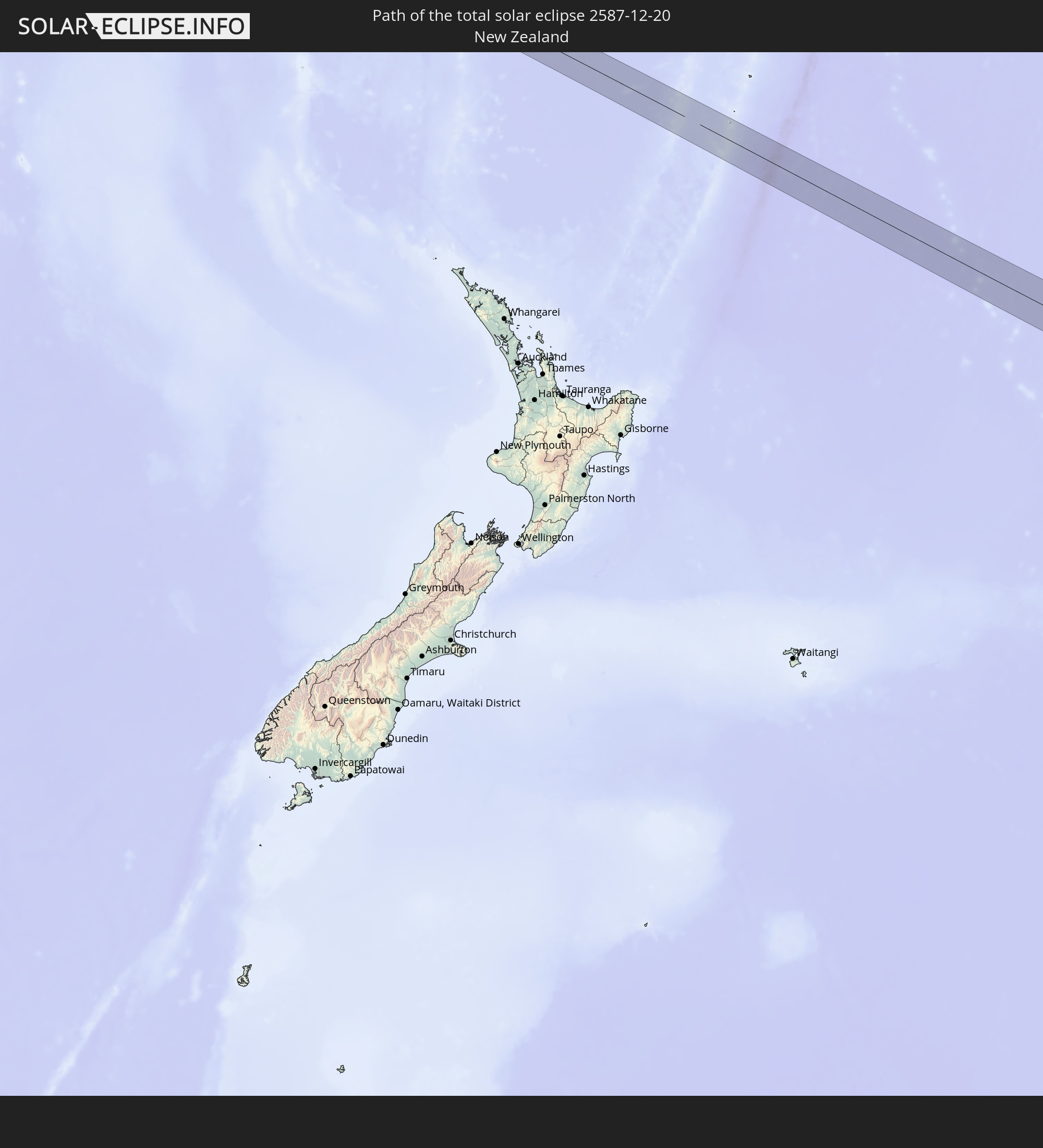 New Zealand
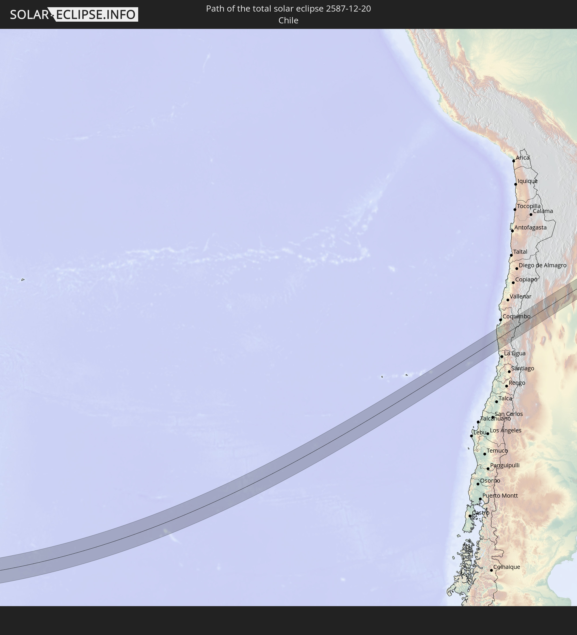 Chile
Chile
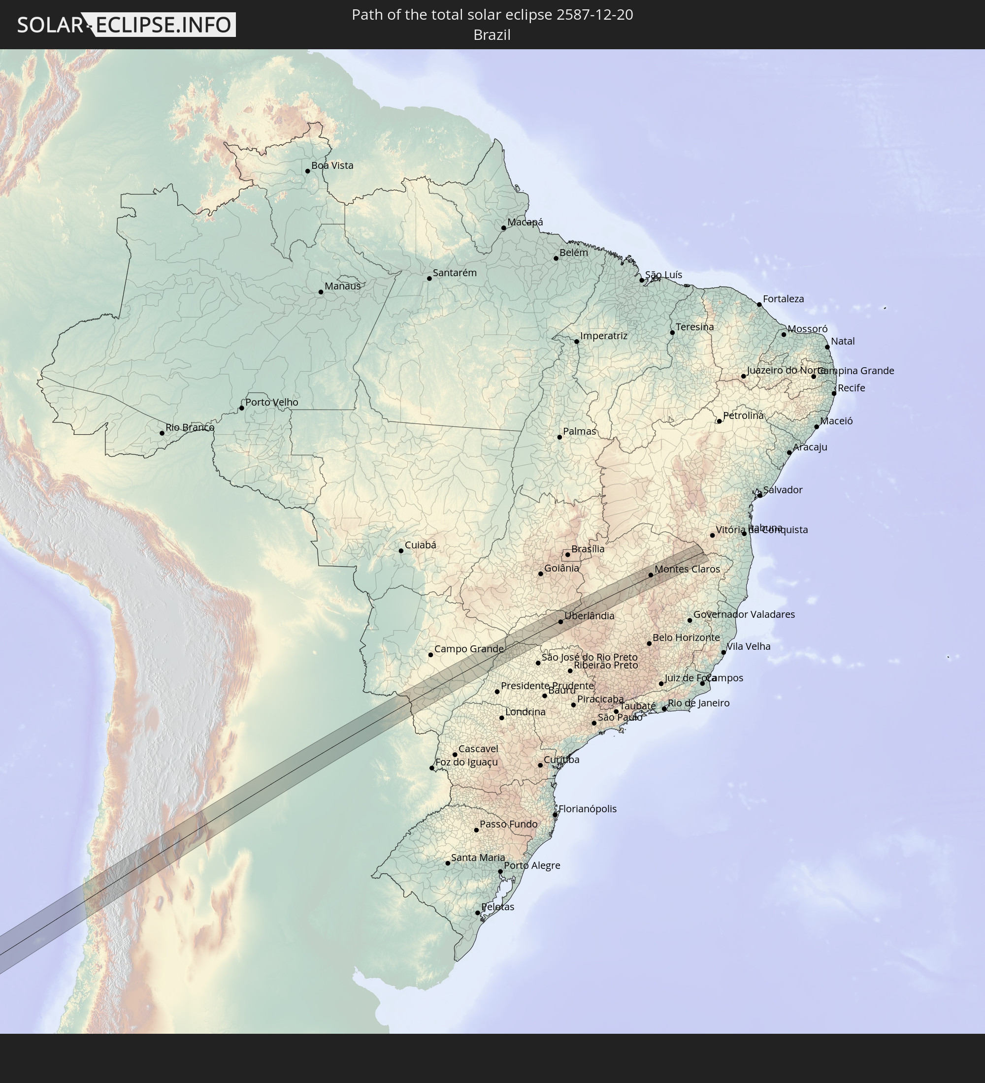 Brazil
 Argentina
 Paraguay
In den folgenden Ländern ist die Sonnenfinsternis partiell zu sehen
 Antarctica
 Fiji
Fiji
 New Zealand
 Wallis and Futuna
 Tonga
Tonga
 Kiribati
 Samoa
Samoa
 Tokelau
 American Samoa
 Niue
Niue
 Cook Islands
 French Polynesia
 Pitcairn Islands
 Chile
Chile
 Ecuador
 Colombia
 Peru
Peru
 Brazil
 Argentina
 Venezuela
 Bolivia
 Paraguay
 Trinidad and Tobago
 Falkland Islands
 Guyana
 Uruguay
 Suriname
 French Guiana
 South Georgia and the South Sandwich Islands
 Australia
 New Caledonia
 Norfolk Island
 Tuvalu
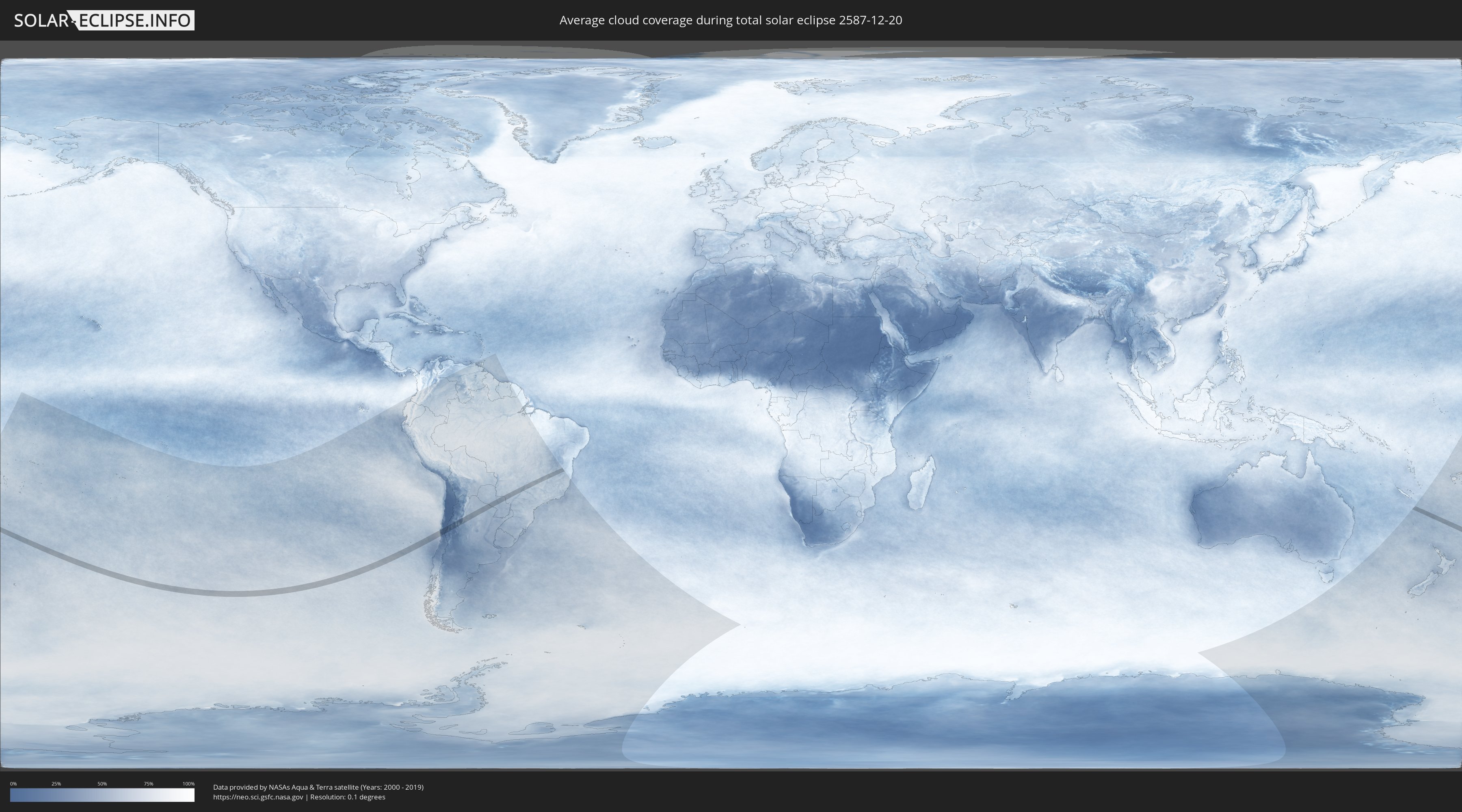
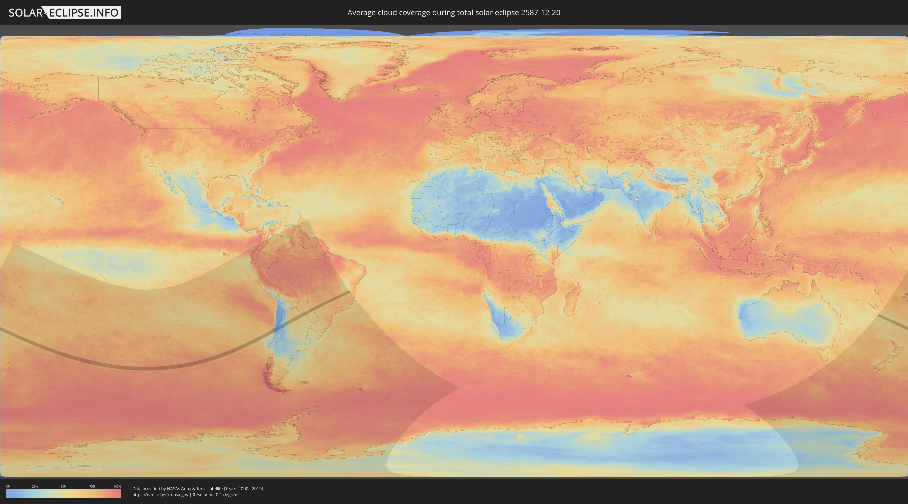
How will be the weather during the total solar eclipse on 12/20/2587?
Where is the best place to see the total solar eclipse of 12/20/2587?
The following maps show the average cloud coverage for the day of the total solar eclipse.
With the help of these maps, it is possible to find the place along the eclipse path, which has the best
chance of a cloudless sky.
Nevertheless, you should consider local circumstances and inform about the weather of your chosen
observation site.
The data is provided by NASAs satellites
AQUA and TERRA.
The cloud maps are averaged over a period of 19 years (2000 - 2019).
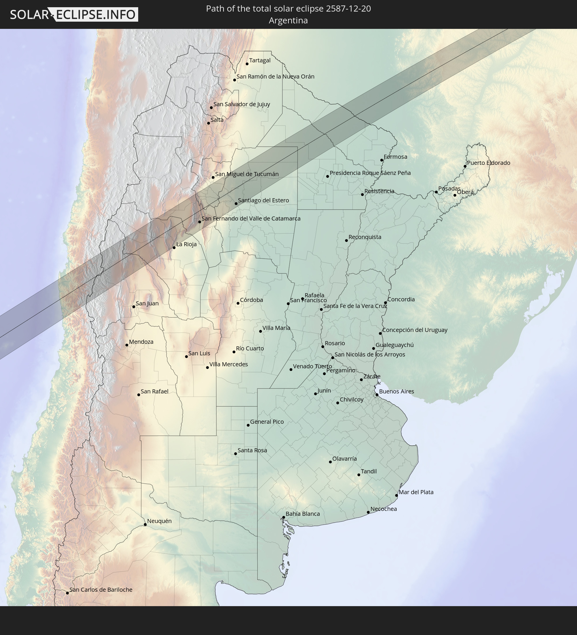
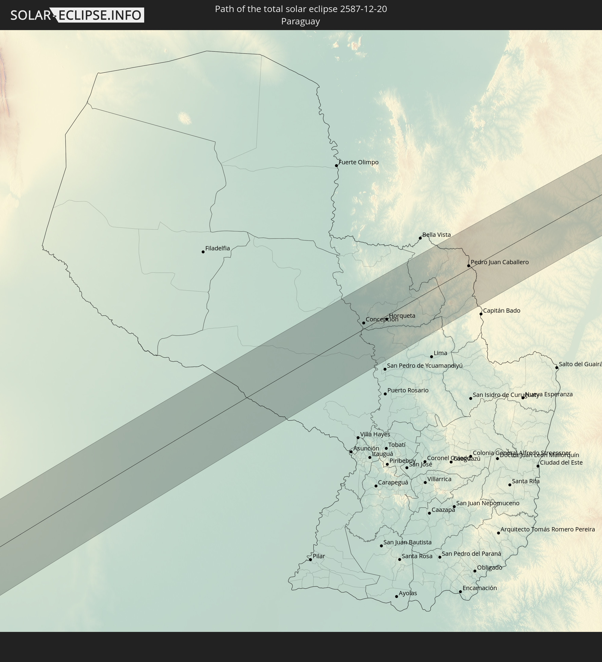
Detailed country maps
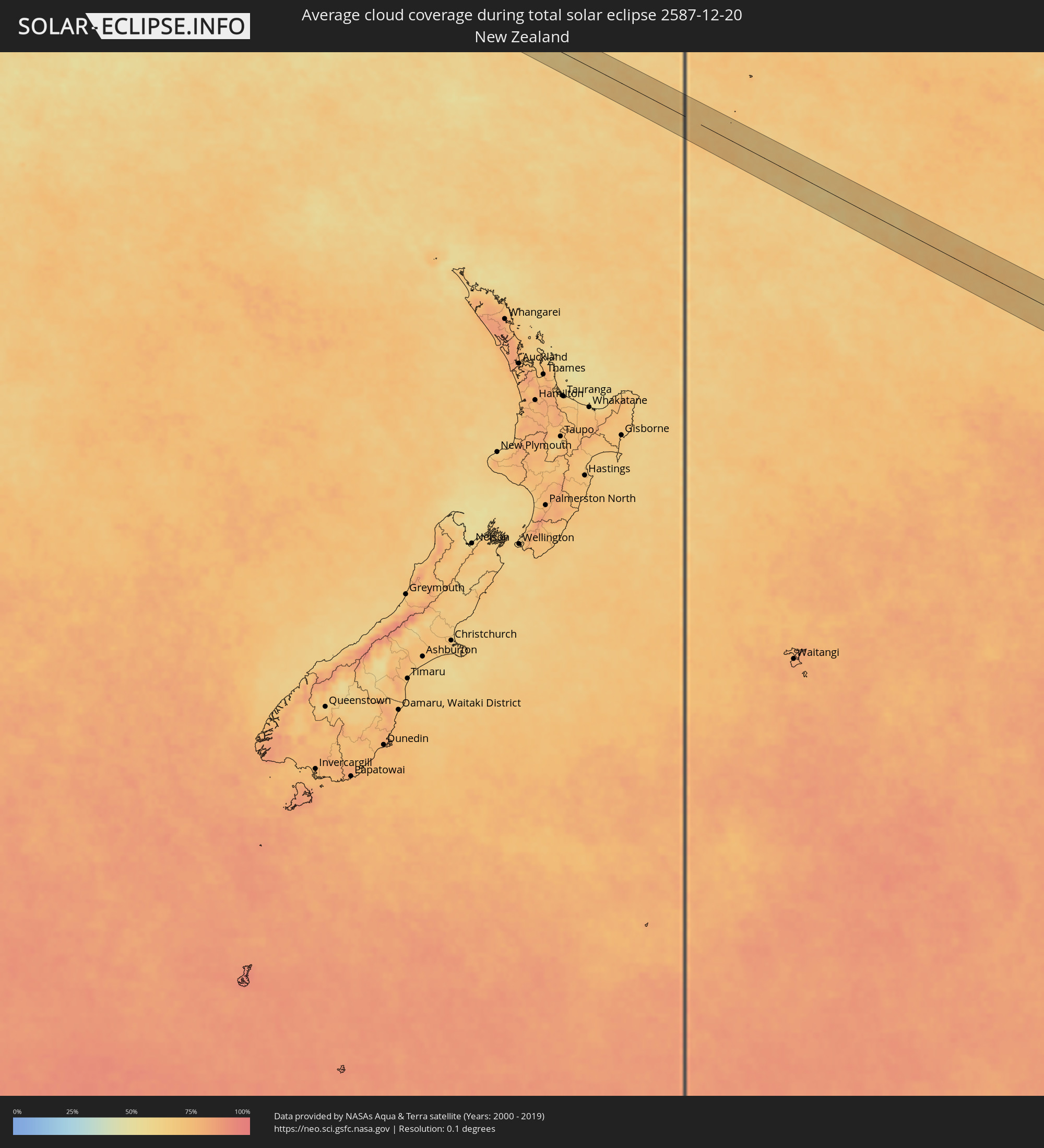 New Zealand
 Chile
Chile
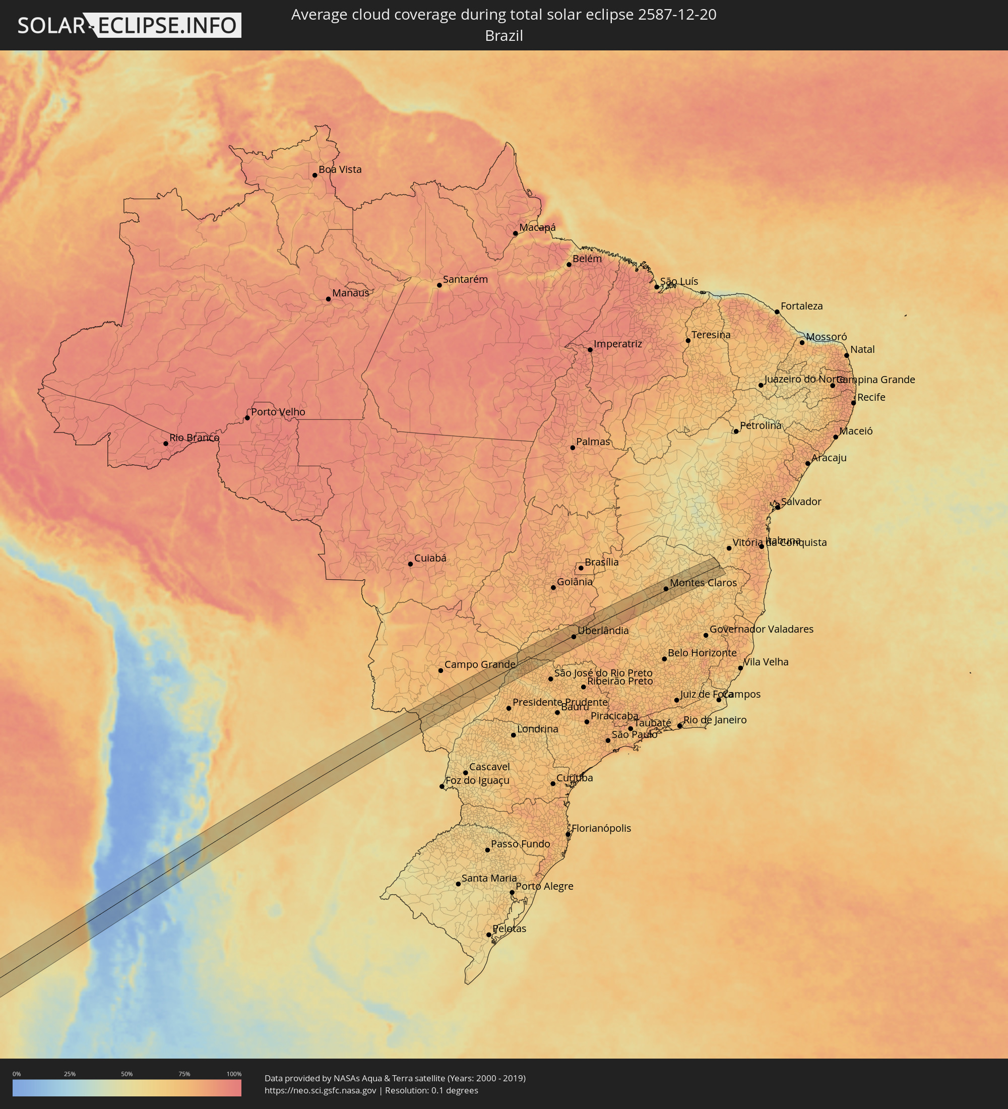 Brazil
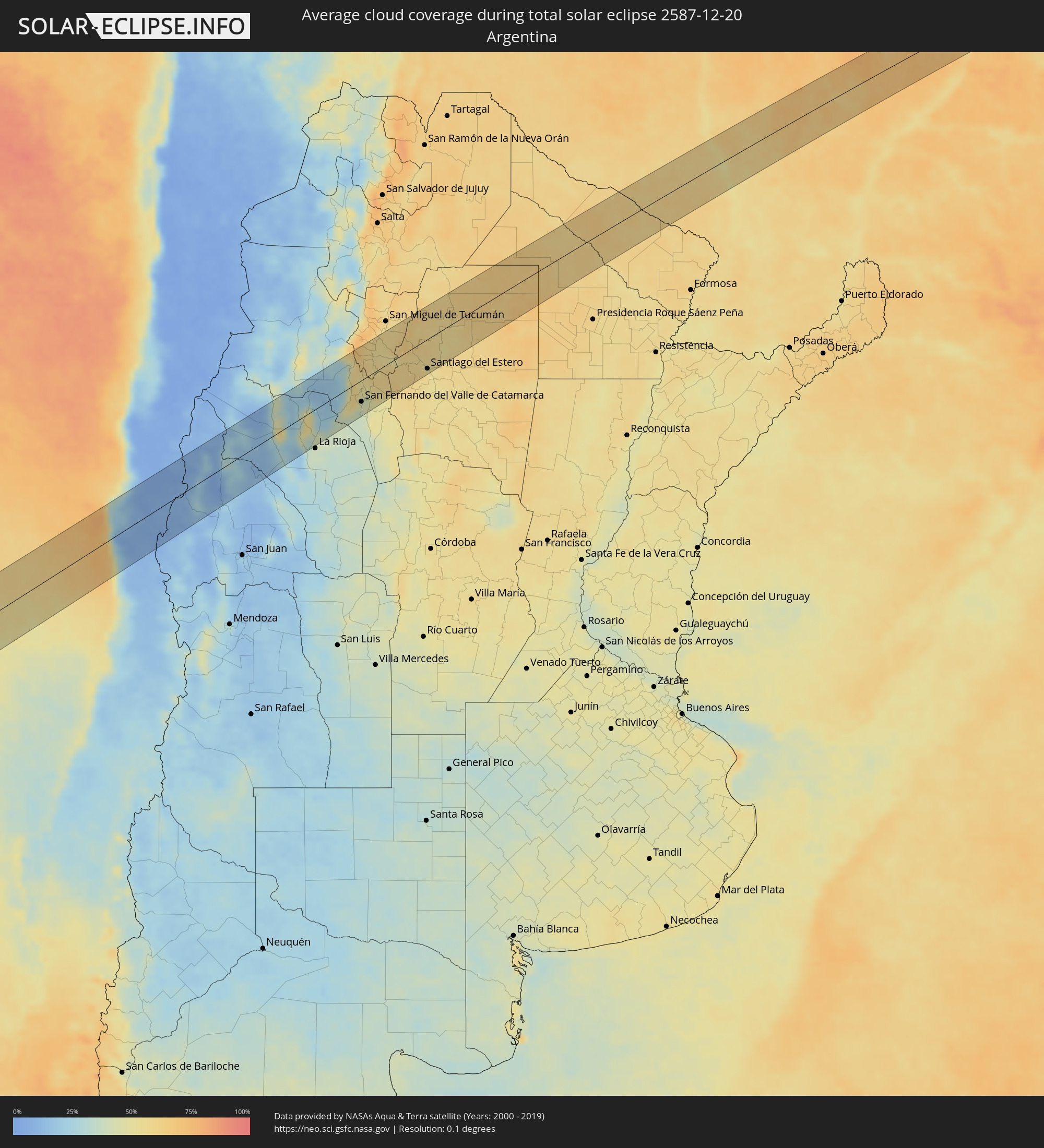 Argentina
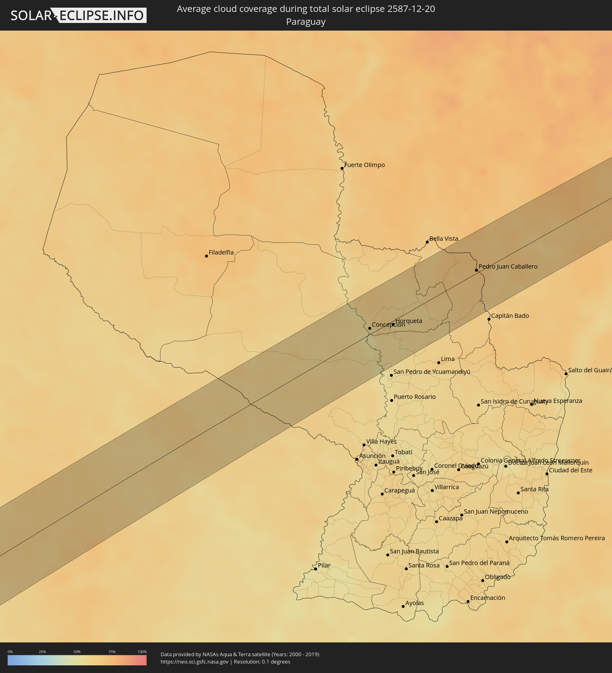 Paraguay
Cities inside the path of the eclipse
The following table shows all locations with a population of more than 5,000 inside the eclipse path. Cities which have more than 100,000 inhabitants are marked bold. A click at the locations opens a detailed map.
| City | Type | Eclipse duration | Local time of max. eclipse | Distance to central line | Ø Cloud coverage |
|
Ovalle, Coquimbo
|
total | - | 17:49:25 UTC-03:00 | 39 km | 15% |
|
Illapel, Coquimbo
|
total | - | 17:47:57 UTC-03:00 | 59 km | 14% |
|
Monte Patria, Coquimbo
|
total | - | 17:49:26 UTC-03:00 | 18 km | 9% |
|
Vicuña, Coquimbo
|
total | - | 17:50:32 UTC-03:00 | 67 km | 5% |
|
San José de Jáchal, San Juan Province
|
total | - | 17:51:26 UTC-03:00 | 54 km | 17% |
|
Chilecito, La Rioja Province
|
total | - | 17:53:36 UTC-03:00 | 17 km | 24% |
|
Arauco, La Rioja Province
|
total | - | 17:54:44 UTC-03:00 | 1 km | 21% |
|
Capayán, Catamarca Province
|
total | - | 17:54:51 UTC-03:00 | 55 km | 37% |
|
Huillapima, Catamarca Province
|
total | - | 17:54:56 UTC-03:00 | 55 km | 40% |
|
San Fernando del Valle de Catamarca, Catamarca Province
|
total | - | 17:55:21 UTC-03:00 | 41 km | 43% |
|
Aguilares, Tucumán Province
|
total | - | 17:56:49 UTC-03:00 | 48 km | 57% |
|
La Cocha, Tucumán Province
|
total | - | 17:56:23 UTC-03:00 | 13 km | 57% |
|
Los Altos, Catamarca Province
|
total | - | 17:56:03 UTC-03:00 | 16 km | 59% |
|
Monteros, Tucumán Province
|
total | - | 17:57:13 UTC-03:00 | 67 km | 55% |
|
Graneros, Tucumán Province
|
total | - | 17:56:36 UTC-03:00 | 18 km | 57% |
|
Simoca, Tucumán Province
|
total | - | 17:57:09 UTC-03:00 | 50 km | 54% |
|
Termas de Río Hondo, Santiago del Estero Province
|
total | - | 17:57:03 UTC-03:00 | 3 km | 55% |
|
Santiago del Estero, Santiago del Estero Province
|
total | - | 17:56:53 UTC-03:00 | 57 km | 55% |
|
Clodomira, Santiago del Estero Province
|
total | - | 17:57:14 UTC-03:00 | 43 km | 55% |
|
Campo Gallo, Santiago del Estero Province
|
total | - | 17:58:58 UTC-03:00 | 16 km | 63% |
|
Las Lomitas, Formosa Province
|
total | - | 18:01:56 UTC-03:00 | 45 km | 63% |
|
Ibarreta, Formosa Province
|
total | - | 18:01:29 UTC-03:00 | 41 km | 62% |
|
Comandante Fontana, Formosa Province
|
total | - | 18:01:23 UTC-03:00 | 62 km | 61% |
|
Concepción, Concepción
|
total | - | 18:04:03 UTC-03:00 | 8 km | 52% |
|
Horqueta, Concepción
|
total | - | 18:04:09 UTC-03:00 | 5 km | 60% |
|
Pedro Juan Caballero, Amambay
|
total | - | 18:05:10 UTC-03:00 | 4 km | 69% |
|
Ponta Porã, Mato Grosso do Sul
|
total | - | 17:05:11 UTC-04:00 | 5 km | 69% |
|
Caarapó, Mato Grosso do Sul
|
total | - | 17:05:08 UTC-04:00 | 51 km | 63% |
|
Dourados, Mato Grosso do Sul
|
total | - | 17:05:35 UTC-04:00 | 11 km | 68% |
|
Rio Brilhante, Mato Grosso do Sul
|
total | - | 17:06:02 UTC-04:00 | 16 km | 64% |
|
Três Lagoas, Mato Grosso do Sul
|
total | - | 17:07:04 UTC-04:00 | 26 km | 63% |
|
Castilho, São Paulo
|
total | - | 18:06:58 UTC-03:00 | 45 km | 68% |
|
Andradina, São Paulo
|
total | - | 18:06:56 UTC-03:00 | 53 km | 71% |
|
Ilha Solteira, São Paulo
|
total | - | 18:07:24 UTC-03:00 | 9 km | 59% |
|
Paranaíba, Mato Grosso do Sul
|
total | - | 17:08:08 UTC-04:00 | 57 km | 70% |
|
Pereira Barreto, São Paulo
|
total | - | 18:07:11 UTC-03:00 | 41 km | 61% |
|
Aparecida do Taboado, Mato Grosso do Sul
|
total | - | 17:07:44 UTC-04:00 | 12 km | 64% |
|
Santa Fé do Sul, São Paulo
|
total | - | 18:07:35 UTC-03:00 | 8 km | 68% |
|
Jales, São Paulo
|
total | - | 18:07:30 UTC-03:00 | 32 km | 74% |
|
Fernandópolis, São Paulo
|
total | - | 18:07:27 UTC-03:00 | 49 km | 73% |
|
Iturama, Minas Gerais
|
total | - | 18:08:00 UTC-03:00 | 4 km | 71% |
|
Cardoso, São Paulo
|
total | - | 18:07:37 UTC-03:00 | 45 km | 70% |
|
Riolândia, São Paulo
|
total | - | 18:07:42 UTC-03:00 | 46 km | 70% |
|
Campina Verde, Minas Gerais
|
total | - | 18:08:06 UTC-03:00 | 12 km | 72% |
|
Ituiutaba, Minas Gerais
|
total | - | 18:08:38 UTC-03:00 | 43 km | 74% |
|
Prata, Minas Gerais
|
total | - | 18:08:15 UTC-03:00 | 16 km | 77% |
|
Monte Alegre de Minas, Minas Gerais
|
total | - | 18:08:39 UTC-03:00 | 25 km | 81% |
|
Tupaciguara, Minas Gerais
|
total | - | 18:08:53 UTC-03:00 | 44 km | 77% |
|
Uberlândia, Minas Gerais
|
total | - | 18:08:31 UTC-03:00 | 9 km | 76% |
|
Araguari, Minas Gerais
|
total | - | 18:08:45 UTC-03:00 | 14 km | 76% |
|
Catalão, Goiás
|
total | - | 18:09:09 UTC-03:00 | 50 km | 78% |
|
Monte Carmelo, Minas Gerais
|
total | - | 18:08:34 UTC-03:00 | 27 km | 79% |
|
Coromandel, Minas Gerais
|
total | - | 18:08:44 UTC-03:00 | 16 km | 74% |
|
Vazante, Minas Gerais
|
total | - | 18:09:07 UTC-03:00 | 19 km | 72% |
|
Presidente Olegário, Minas Gerais
|
total | - | 18:08:38 UTC-03:00 | 47 km | 77% |
|
João Pinheiro, Minas Gerais
|
total | - | 18:09:11 UTC-03:00 | 9 km | 73% |
|
Buritizeiro, Minas Gerais
|
total | - | 18:09:15 UTC-03:00 | 9 km | 68% |
|
Pirapora, Minas Gerais
|
total | - | 18:09:15 UTC-03:00 | 9 km | 69% |
|
Várzea da Palma, Minas Gerais
|
total | - | 18:08:58 UTC-03:00 | 44 km | 68% |
|
Coração de Jesus, Minas Gerais
|
total | - | 18:09:39 UTC-03:00 | 31 km | 73% |
|
Montes Claros, Minas Gerais
|
total | - | 18:09:28 UTC-03:00 | 3 km | 70% |
|
Bocaiúva, Minas Gerais
|
total | - | 18:09:09 UTC-03:00 | 37 km | 67% |
|
Francisco Sá, Minas Gerais
|
total | - | 18:09:35 UTC-03:00 | 12 km | 68% |
|
Salinas, Minas Gerais
|
total | - | 18:09:28 UTC-03:00 | 12 km | 61% |
|
Taiobeiras, Minas Gerais
|
total | - | 18:09:44 UTC-03:00 | 22 km | 66% |
|
Águas Vermelhas, Minas Gerais
|
total | - | 18:09:32 UTC-03:00 | 6 km | 65% |
|
Pedra Azul, Minas Gerais
|
total | - | 18:09:16 UTC-03:00 | 39 km | 62% |