Total solar eclipse of 04/03/2592
| Day of week: | Tuesday |
| Maximum duration of eclipse: | 03m32s |
| Maximum width of eclipse path: | 137 km |
| Saros cycle: | 158 |
| Coverage: | 100% |
| Magnitude: | 1.0378 |
| Gamma: | -0.3902 |
Wo kann man die Sonnenfinsternis vom 04/03/2592 sehen?
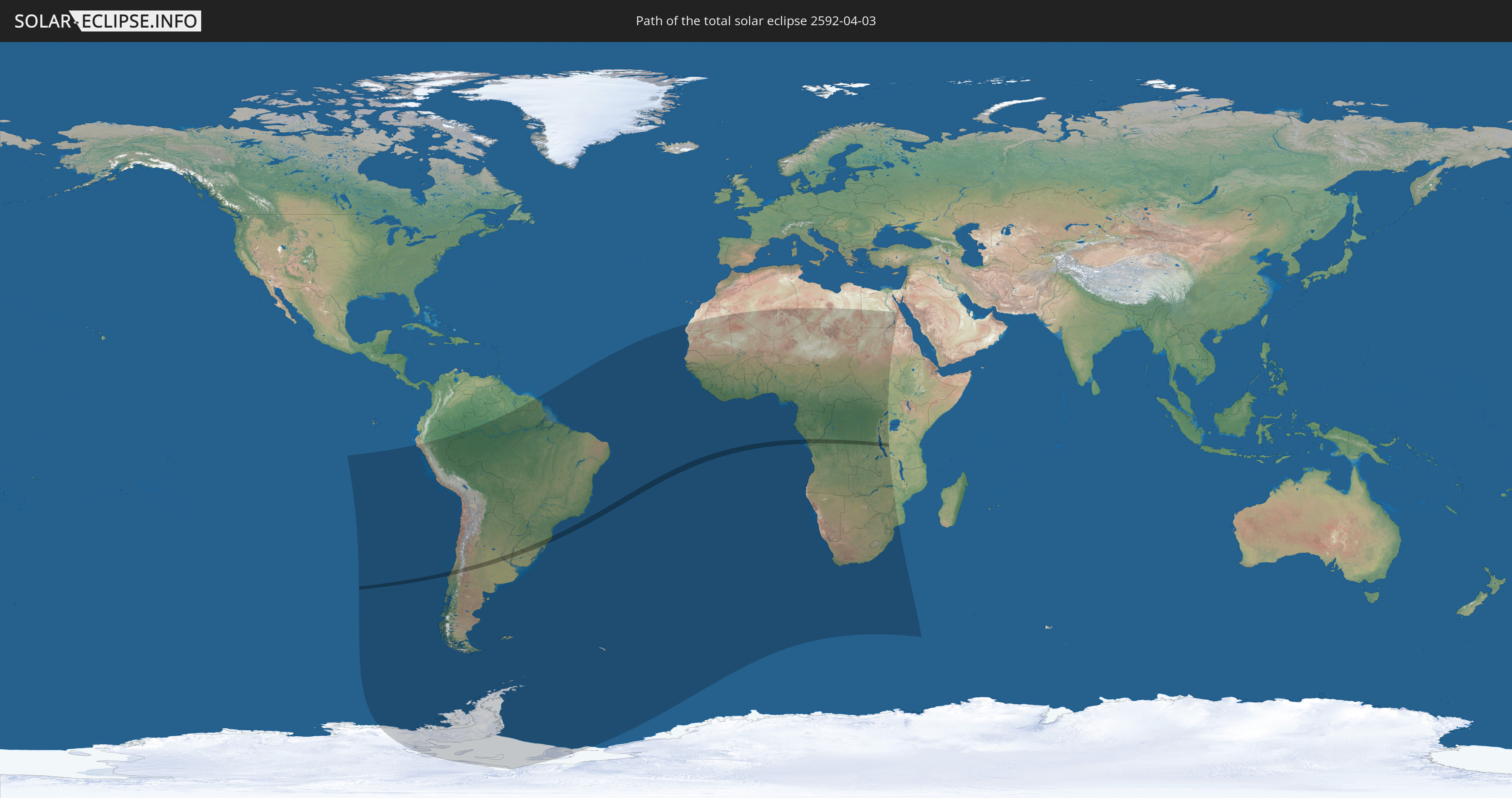
Die Sonnenfinsternis am 04/03/2592 kann man in 57 Ländern als partielle Sonnenfinsternis beobachten.
Der Finsternispfad verläuft durch 8 Länder. Nur in diesen Ländern ist sie als total Sonnenfinsternis zu sehen.
In den folgenden Ländern ist die Sonnenfinsternis total zu sehen
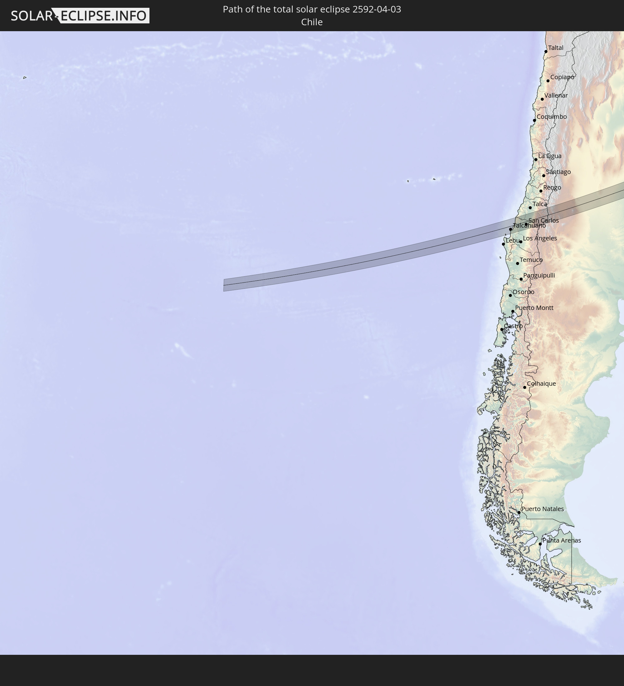 Chile
Chile
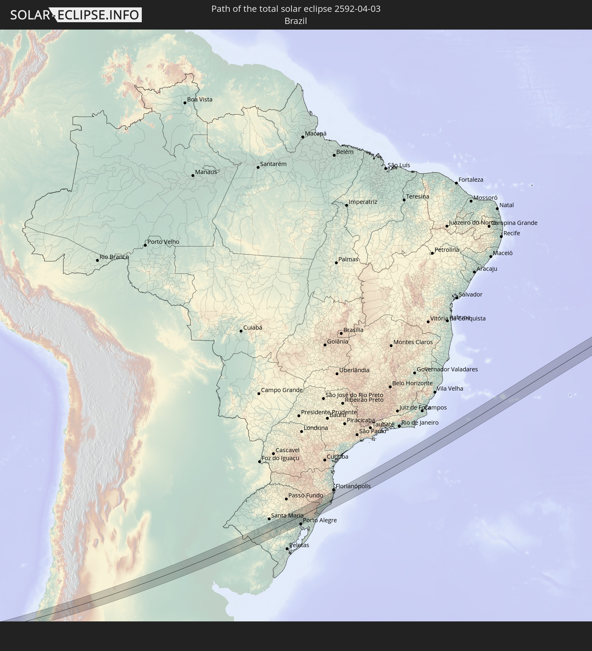 Brazil
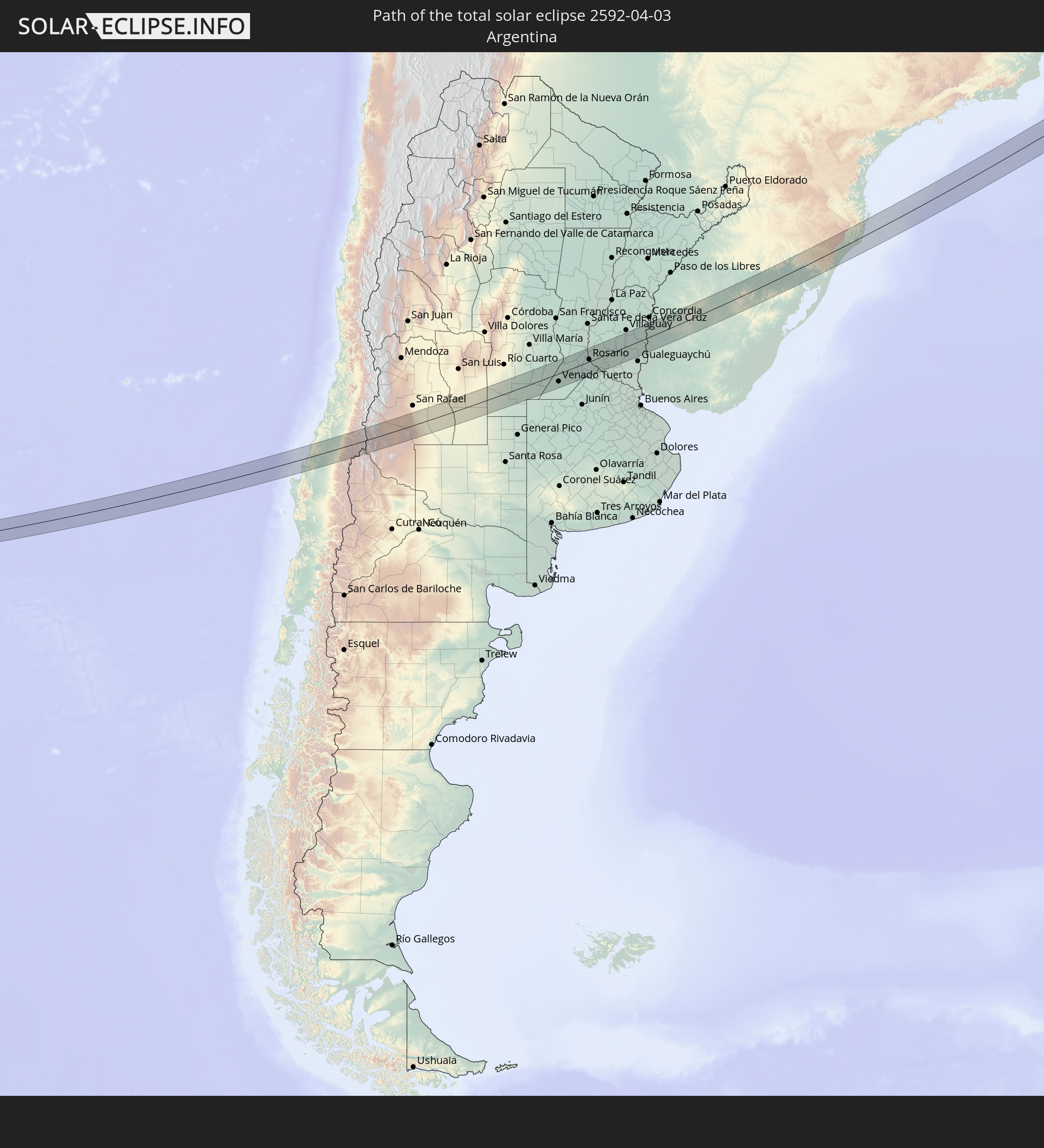 Argentina
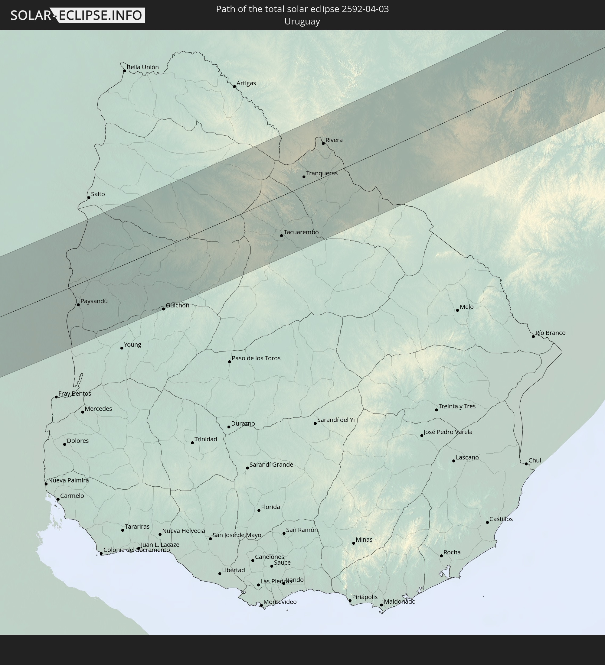 Uruguay
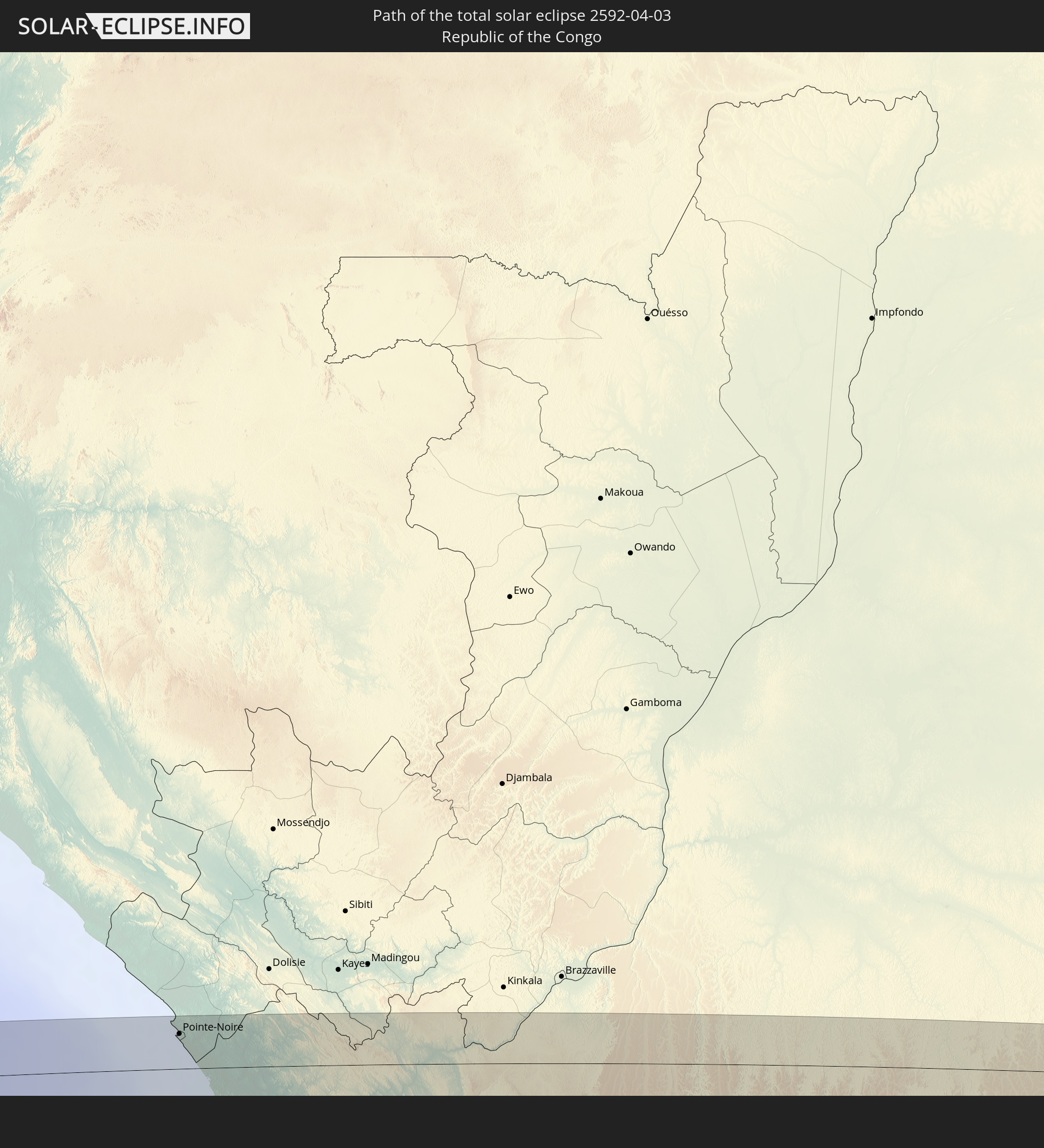 Republic of the Congo
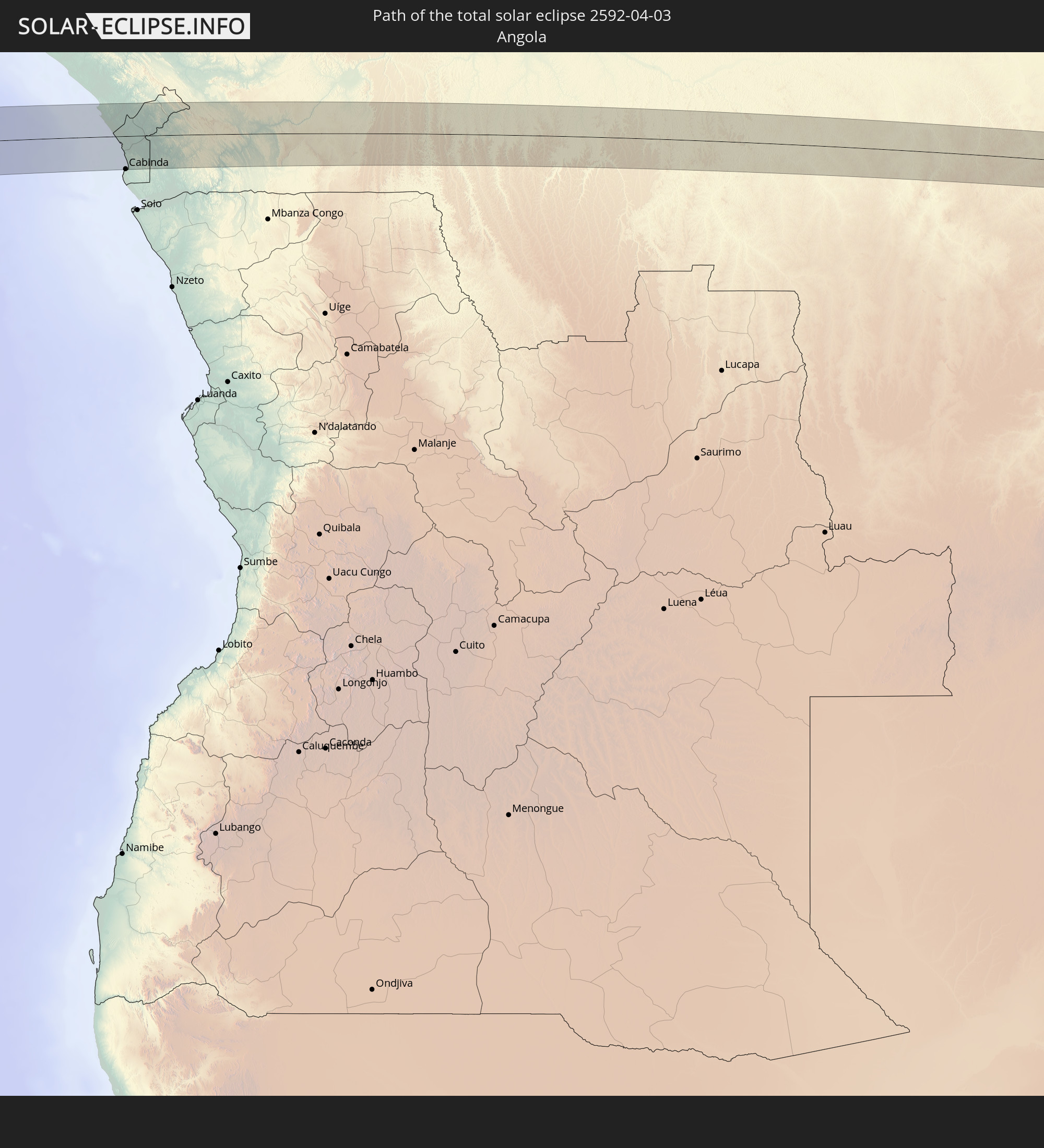 Angola
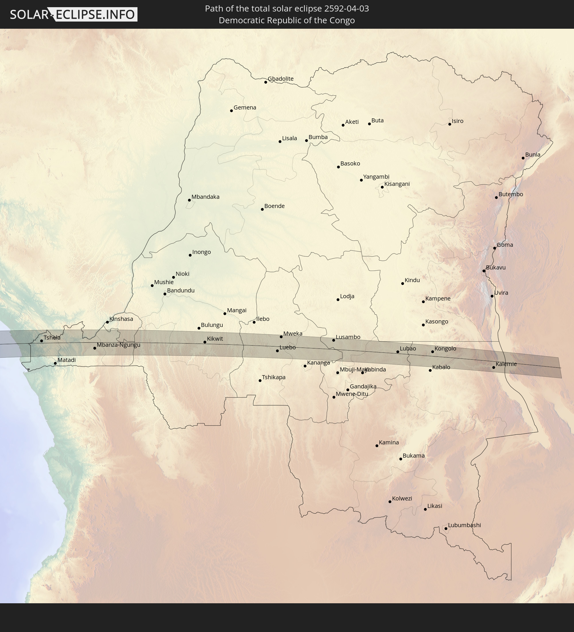 Democratic Republic of the Congo
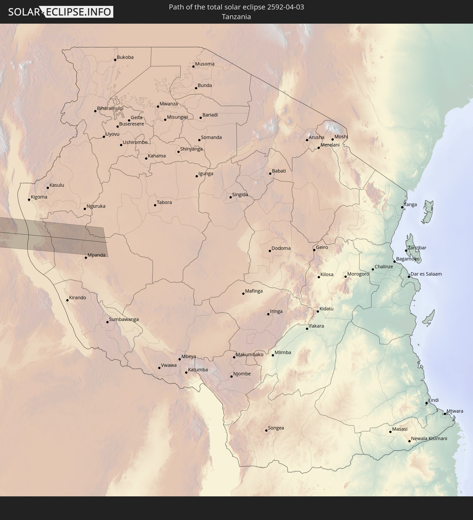 Tanzania
In den folgenden Ländern ist die Sonnenfinsternis partiell zu sehen
 Antarctica
 Chile
Chile
 Colombia
 Peru
Peru
 Brazil
 Argentina
 Bolivia
 Paraguay
 Falkland Islands
 Guyana
 Uruguay
 Suriname
 French Guiana
 South Georgia and the South Sandwich Islands
 Cabo Verde
 Senegal
 Mauritania
 The Gambia
 Guinea-Bissau
 Guinea
 Saint Helena, Ascension and Tristan da Cunha
 Sierra Leone
 Mali
Mali
 Liberia
 Algeria
 Ivory Coast
 Burkina Faso
 Ghana
Ghana
 Togo
Togo
 Niger
Niger
 Benin
Benin
 Nigeria
 Bouvet Island
 Equatorial Guinea
 São Tomé and Príncipe
 Cameroon
 Gabon
Gabon
 Libya
Libya
 Republic of the Congo
 Angola
 Namibia
 Democratic Republic of the Congo
 Chad
Chad
 Central African Republic
 South Africa
 Botswana
 Sudan
Sudan
 Zambia
 Egypt
Egypt
 Zimbabwe
 Lesotho
 Rwanda
 Burundi
 Tanzania
 Uganda
 Mozambique
 Swaziland
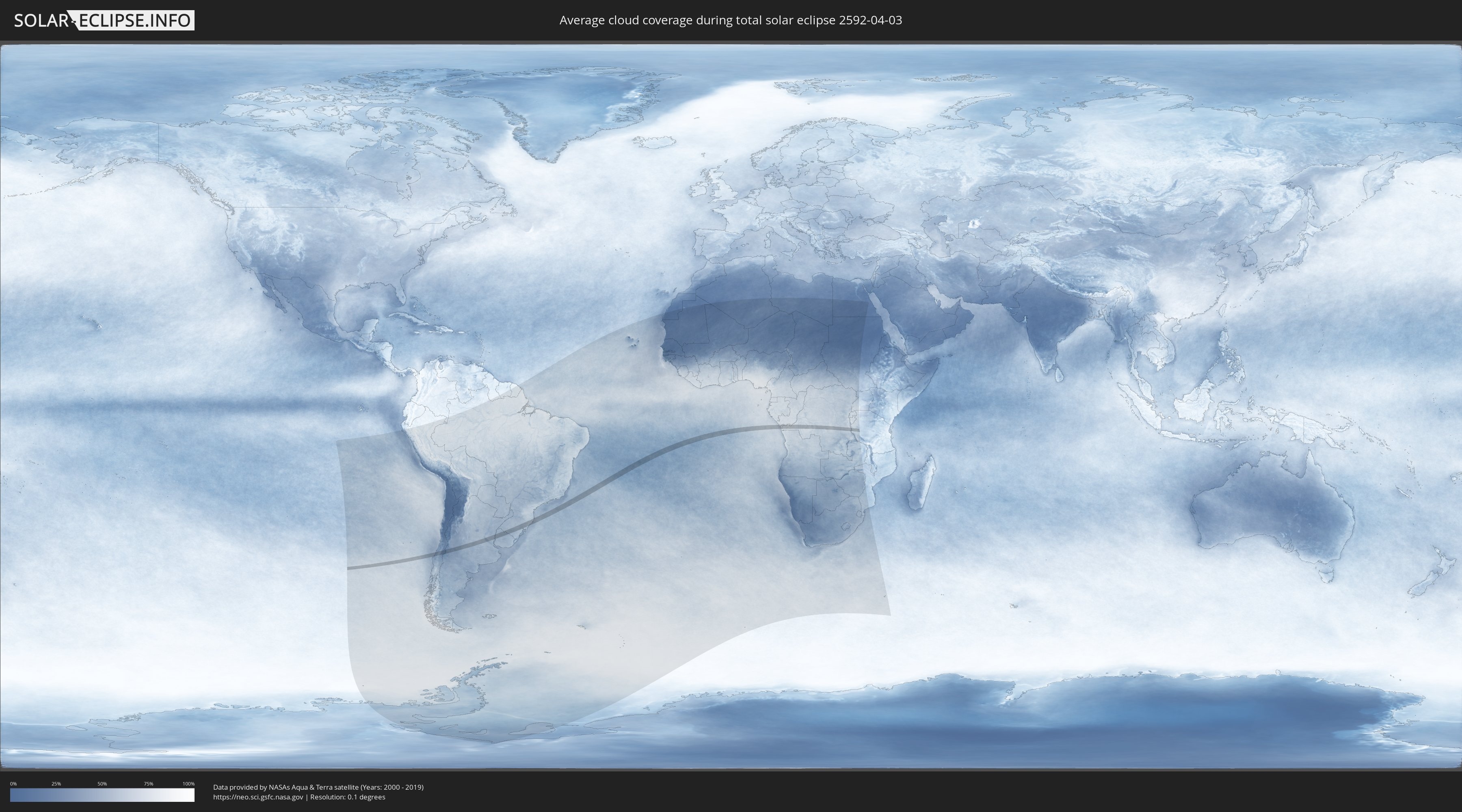
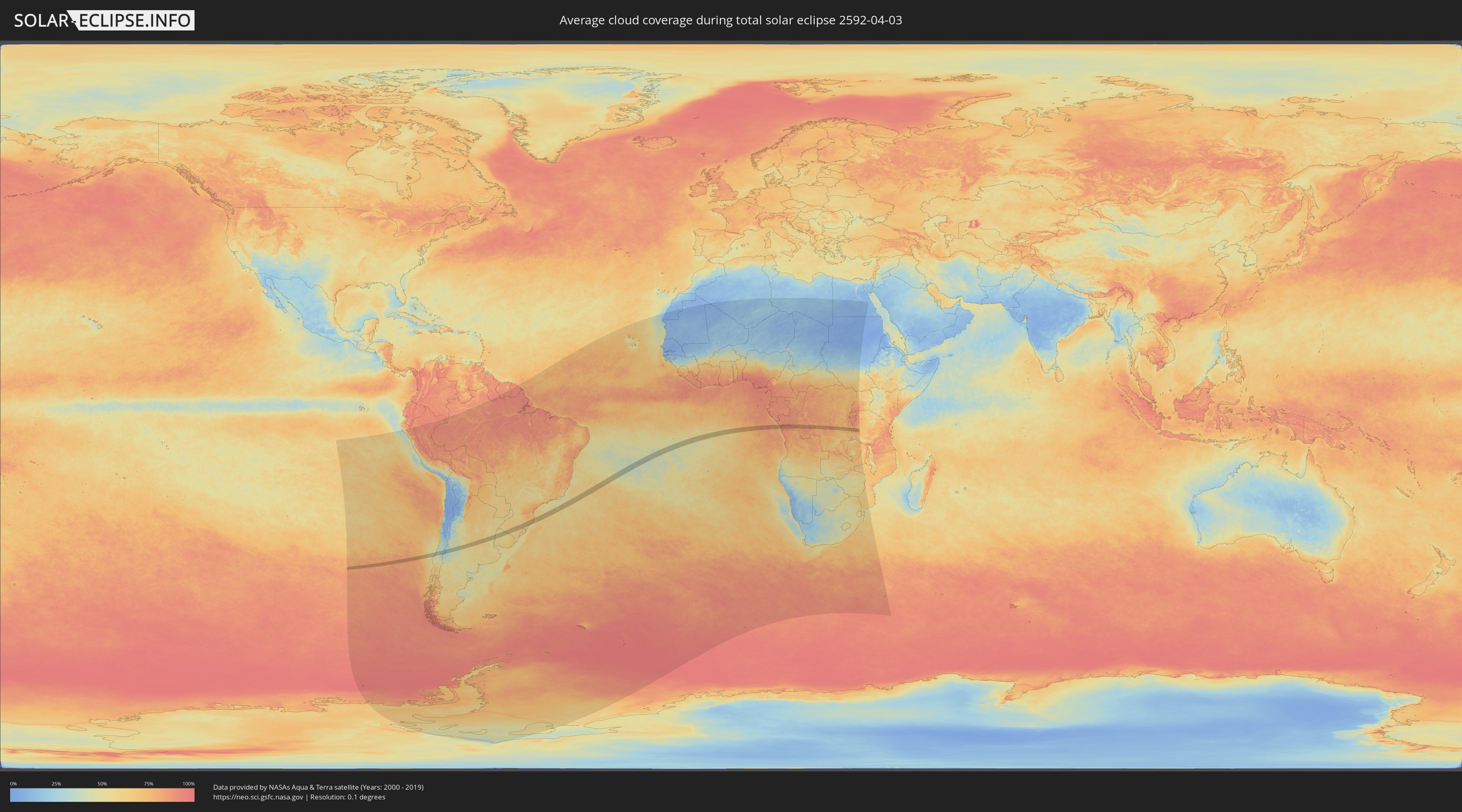
How will be the weather during the total solar eclipse on 04/03/2592?
Where is the best place to see the total solar eclipse of 04/03/2592?
The following maps show the average cloud coverage for the day of the total solar eclipse.
With the help of these maps, it is possible to find the place along the eclipse path, which has the best
chance of a cloudless sky.
Nevertheless, you should consider local circumstances and inform about the weather of your chosen
observation site.
The data is provided by NASAs satellites
AQUA and TERRA.
The cloud maps are averaged over a period of 19 years (2000 - 2019).
Detailed country maps
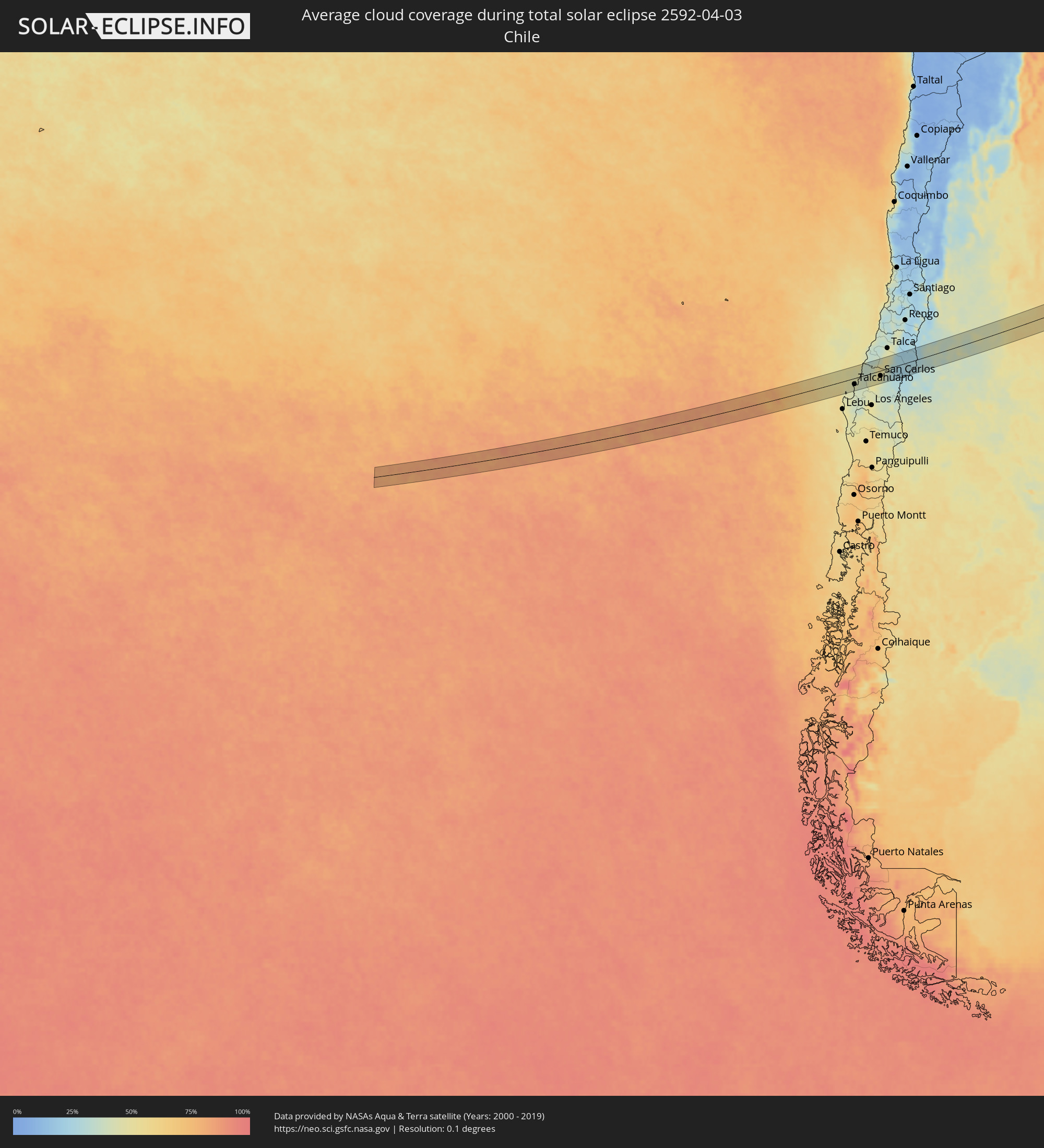 Chile
Chile
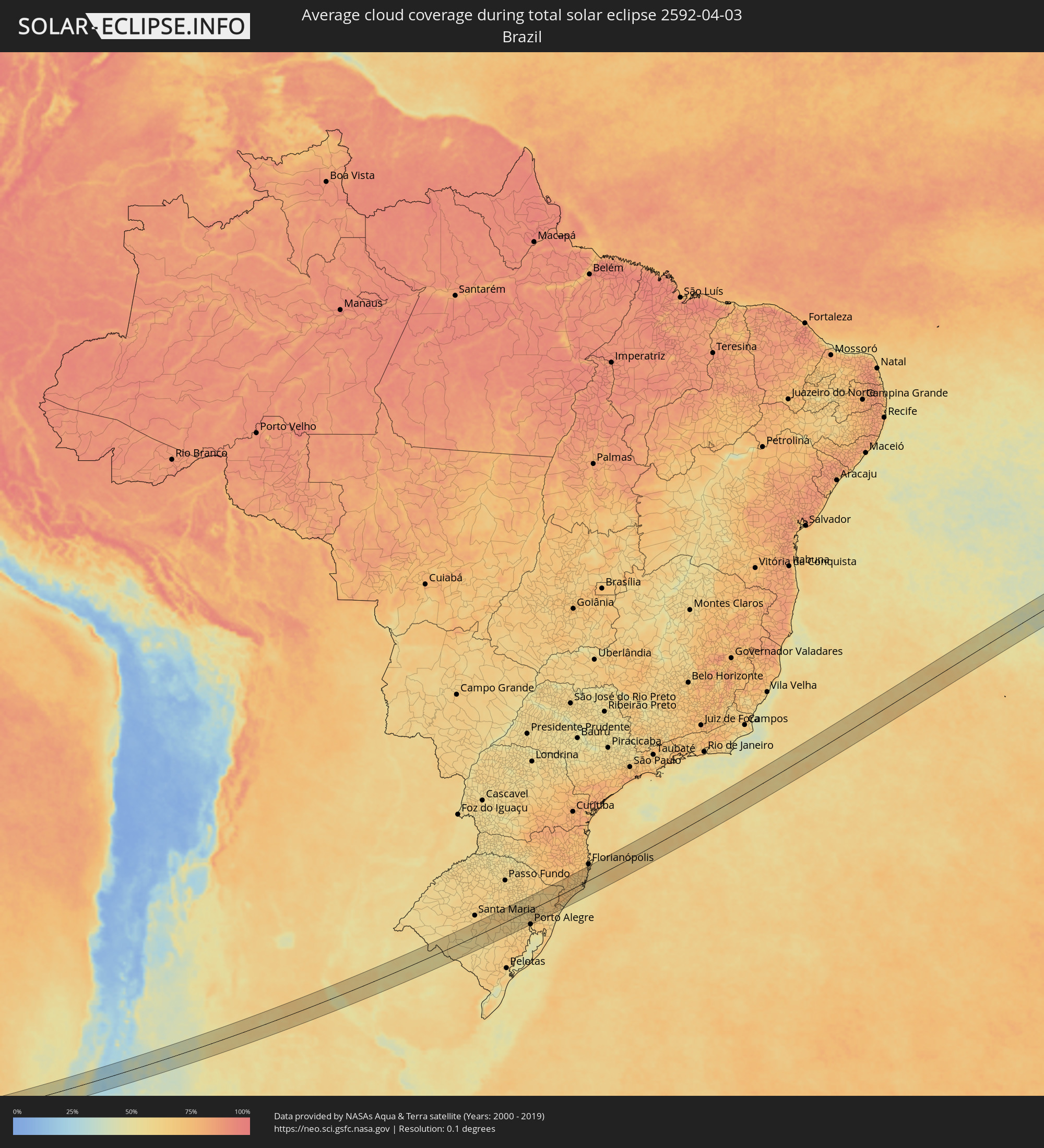 Brazil
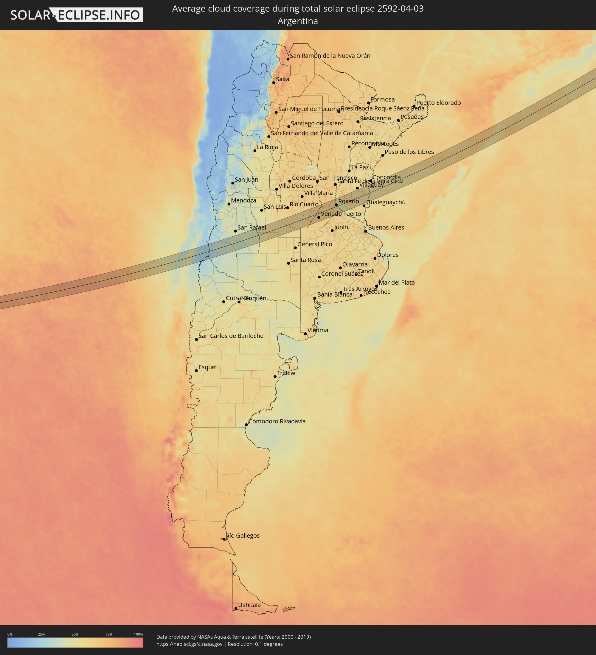 Argentina
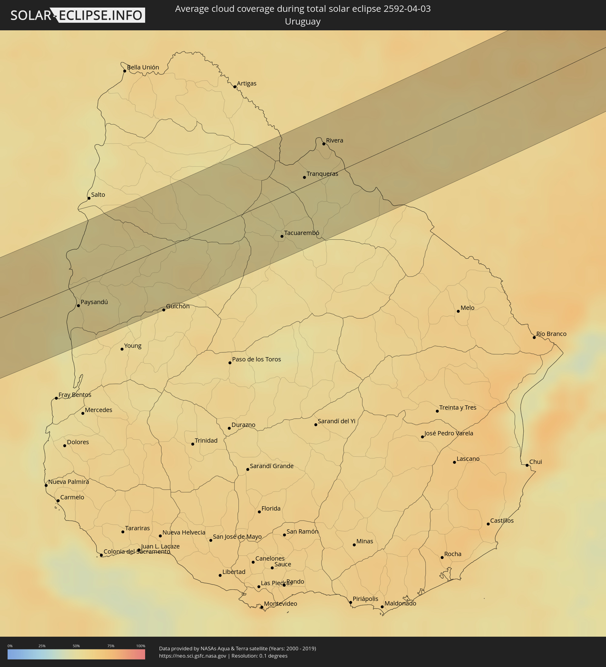 Uruguay
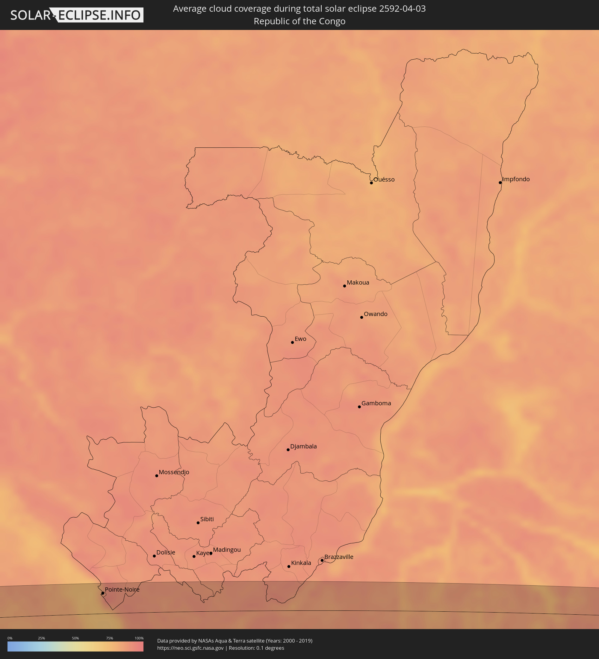 Republic of the Congo
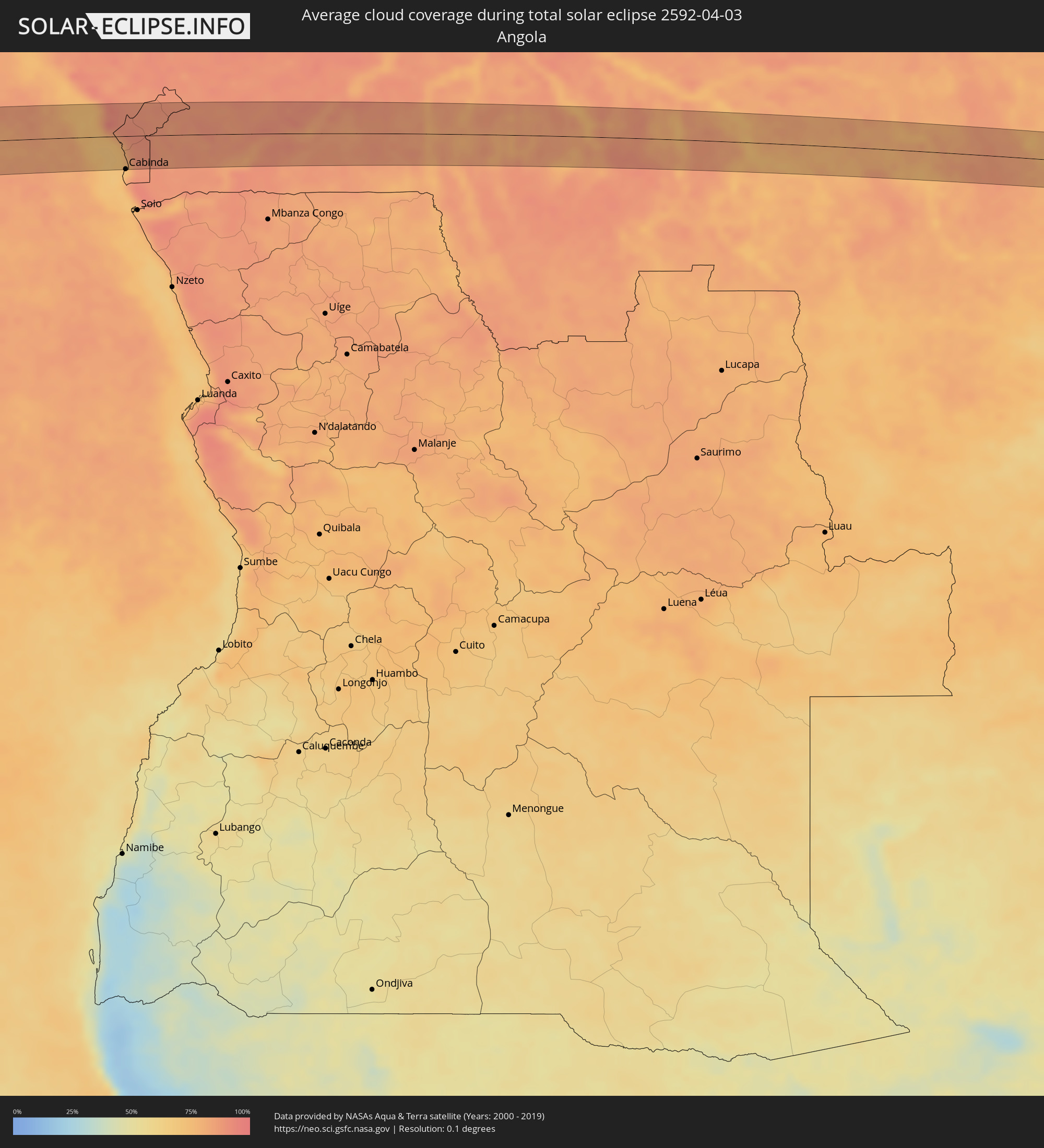 Angola
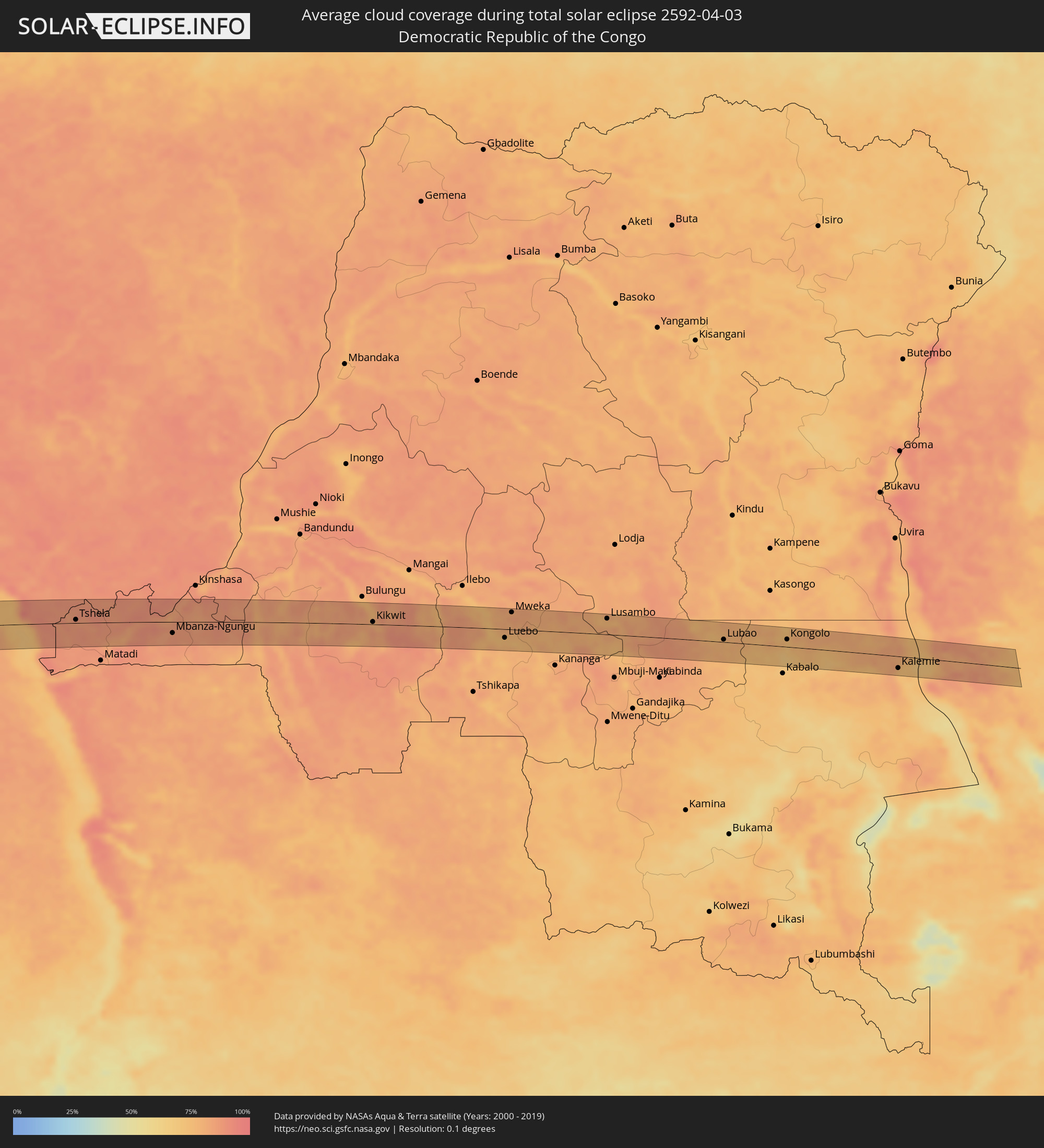 Democratic Republic of the Congo
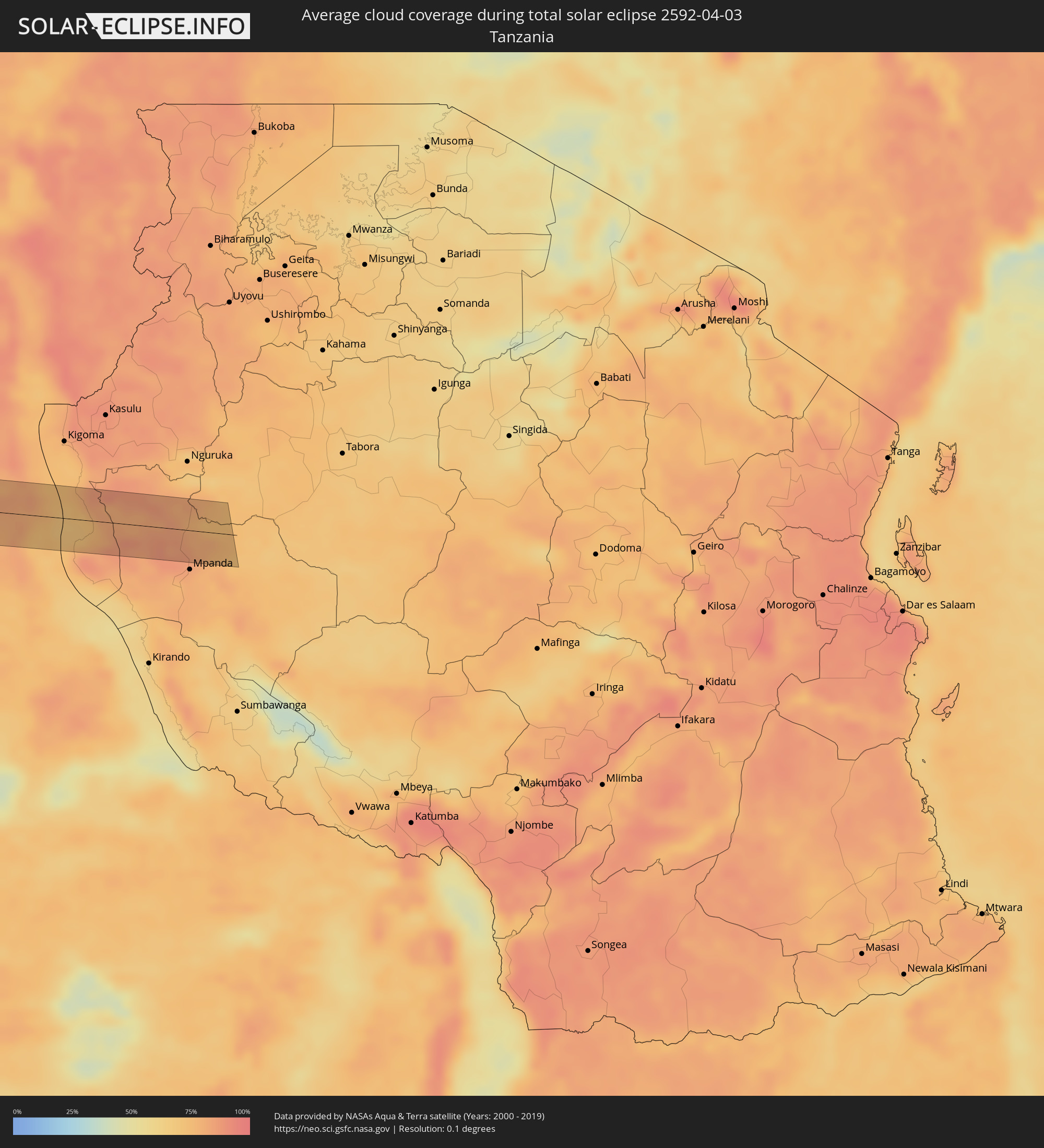 Tanzania
Cities inside the path of the eclipse
The following table shows all locations with a population of more than 5,000 inside the eclipse path. Cities which have more than 100,000 inhabitants are marked bold. A click at the locations opens a detailed map.
| City | Type | Eclipse duration | Local time of max. eclipse | Distance to central line | Ø Cloud coverage |
|
Talcahuano, Biobío
|
total | - | 09:46:17 UTC-03:00 | 23 km | 45% |
|
Concepción, Biobío
|
total | - | 09:46:22 UTC-03:00 | 36 km | 40% |
|
Chiguayante, Biobío
|
total | - | 09:46:26 UTC-03:00 | 47 km | 39% |
|
Penco, Biobío
|
total | - | 09:46:22 UTC-03:00 | 28 km | 43% |
|
Tomé, Biobío
|
total | - | 09:46:21 UTC-03:00 | 15 km | 43% |
|
Cauquenes, Maule
|
total | - | 09:46:32 UTC-03:00 | 38 km | 40% |
|
Bulnes, Biobío
|
total | - | 09:46:52 UTC-03:00 | 45 km | 50% |
|
Chillán, Biobío
|
total | - | 09:46:57 UTC-03:00 | 36 km | 48% |
|
San Carlos, Biobío
|
total | - | 09:46:59 UTC-03:00 | 20 km | 51% |
|
Coihueco, Biobío
|
total | - | 09:47:09 UTC-03:00 | 45 km | 38% |
|
Parral, Maule
|
total | - | 09:46:58 UTC-03:00 | 7 km | 48% |
|
Longaví, Maule
|
total | - | 09:47:00 UTC-03:00 | 22 km | 45% |
|
Linares, Maule
|
total | - | 09:47:02 UTC-03:00 | 33 km | 47% |
|
Vicuña Mackenna, Cordoba Province
|
total | - | 09:52:52 UTC-03:00 | 30 km | 60% |
|
Adelia María, Cordoba Province
|
total | - | 09:53:12 UTC-03:00 | 49 km | 60% |
|
Laboulaye, Cordoba Province
|
total | - | 09:53:57 UTC-03:00 | 23 km | 60% |
|
La Carlota, Cordoba Province
|
total | - | 09:53:56 UTC-03:00 | 48 km | 59% |
|
Canals, Cordoba Province
|
total | - | 09:54:24 UTC-03:00 | 19 km | 61% |
|
Monte Maíz, Cordoba Province
|
total | - | 09:54:40 UTC-03:00 | 47 km | 64% |
|
Arias, Cordoba Province
|
total | - | 09:54:56 UTC-03:00 | 5 km | 63% |
|
Corral de Bustos, Cordoba Province
|
total | - | 09:55:08 UTC-03:00 | 25 km | 64% |
|
Venado Tuerto, Santa Fe Province
|
total | - | 09:55:26 UTC-03:00 | 30 km | 63% |
|
Cruz Alta, Cordoba Province
|
total | - | 09:55:32 UTC-03:00 | 41 km | 63% |
|
Firmat, Santa Fe Province
|
total | - | 09:55:57 UTC-03:00 | 16 km | 62% |
|
Cañada de Gómez, Santa Fe Province
|
total | - | 09:56:00 UTC-03:00 | 47 km | 62% |
|
Casilda, Santa Fe Province
|
total | - | 09:56:17 UTC-03:00 | 16 km | 61% |
|
Carcarañá, Santa Fe Province
|
total | - | 09:56:17 UTC-03:00 | 35 km | 61% |
|
Roldán, Santa Fe Province
|
total | - | 09:56:34 UTC-03:00 | 22 km | 62% |
|
Funes, Santa Fe Province
|
total | - | 09:56:41 UTC-03:00 | 17 km | 61% |
|
Pérez, Santa Fe Province
|
total | - | 09:56:44 UTC-03:00 | 7 km | 60% |
|
Fray Luis A. Beltrán, Santa Fe Province
|
total | - | 09:56:46 UTC-03:00 | 27 km | 59% |
|
Capitán Bermúdez, Santa Fe Province
|
total | - | 09:56:47 UTC-03:00 | 23 km | 59% |
|
Granadero Baigorria, Santa Fe Province
|
total | - | 09:56:47 UTC-03:00 | 20 km | 63% |
|
Rosario, Santa Fe Province
|
total | - | 09:56:53 UTC-03:00 | 8 km | 56% |
|
Arroyo Seco, Santa Fe Province
|
total | - | 09:57:03 UTC-03:00 | 18 km | 61% |
|
Villa Constitución, Santa Fe Province
|
total | - | 09:57:16 UTC-03:00 | 32 km | 57% |
|
San Nicolás de los Arroyos, Buenos Aires
|
total | - | 09:57:24 UTC-03:00 | 47 km | 58% |
|
Victoria, Entre Ríos Province
|
total | - | 09:57:27 UTC-03:00 | 25 km | 50% |
|
Rosario del Tala, Entre Ríos Province
|
total | - | 09:58:41 UTC-03:00 | 22 km | 57% |
|
Urdinarrain, Entre Ríos Province
|
total | - | 09:59:00 UTC-03:00 | 27 km | 58% |
|
Villa Elisa, Entre Ríos Province
|
total | - | 09:59:38 UTC-03:00 | 9 km | 55% |
|
Concepción del Uruguay, Entre Ríos Province
|
total | - | 09:59:50 UTC-03:00 | 30 km | 49% |
|
Paysandú, Paysandú
|
total | - | 10:00:03 UTC-03:00 | 19 km | 53% |
|
Tacuarembó, Tacuarembó
|
total | - | 10:02:53 UTC-03:00 | 36 km | 54% |
|
Tranqueras, Rivera
|
total | - | 10:03:16 UTC-03:00 | 8 km | 51% |
|
Rivera, Rivera
|
total | - | 10:03:35 UTC-03:00 | 30 km | 56% |
|
Santana do Livramento, Rio Grande do Sul
|
total | - | 10:03:37 UTC-03:00 | 31 km | 56% |
|
Dom Pedrito, Rio Grande do Sul
|
total | - | 10:04:50 UTC-03:00 | 12 km | 58% |
|
São Gabriel, Rio Grande do Sul
|
total | - | 10:05:28 UTC-03:00 | 39 km | 58% |
|
Cachoeira do Sul, Rio Grande do Sul
|
total | - | 10:07:42 UTC-03:00 | 11 km | 62% |
|
Candelária, Rio Grande do Sul
|
total | - | 10:07:58 UTC-03:00 | 43 km | 67% |
|
Santa Cruz do Sul, Rio Grande do Sul
|
total | - | 10:08:31 UTC-03:00 | 23 km | 65% |
|
Rio Pardo, Rio Grande do Sul
|
total | - | 10:08:31 UTC-03:00 | 6 km | 60% |
|
Venâncio Aires, Rio Grande do Sul
|
total | - | 10:08:55 UTC-03:00 | 25 km | 63% |
|
Lajeado, Rio Grande do Sul
|
total | - | 10:09:20 UTC-03:00 | 29 km | 58% |
|
Taquari, Rio Grande do Sul
|
total | - | 10:09:23 UTC-03:00 | 8 km | 58% |
|
Teutônia, Rio Grande do Sul
|
total | - | 10:09:35 UTC-03:00 | 24 km | 61% |
|
Charqueadas, Rio Grande do Sul
|
total | - | 10:09:43 UTC-03:00 | 34 km | 60% |
|
Bento Gonçalves, Rio Grande do Sul
|
total | - | 10:10:08 UTC-03:00 | 40 km | 62% |
|
Montenegro, Rio Grande do Sul
|
total | - | 10:10:04 UTC-03:00 | 14 km | 59% |
|
Farroupilha, Rio Grande do Sul
|
total | - | 10:10:24 UTC-03:00 | 27 km | 64% |
|
Canoas, Rio Grande do Sul
|
total | - | 10:10:26 UTC-03:00 | 49 km | 64% |
|
Caxias do Sul, Rio Grande do Sul
|
total | - | 10:10:41 UTC-03:00 | 25 km | 63% |
|
Novo Hamburgo, Rio Grande do Sul
|
total | - | 10:10:36 UTC-03:00 | 28 km | 64% |
|
Parobé, Rio Grande do Sul
|
total | - | 10:11:06 UTC-03:00 | 35 km | 64% |
|
Canela, Rio Grande do Sul
|
total | - | 10:11:13 UTC-03:00 | 9 km | 59% |
|
Torres, Rio Grande do Sul
|
total | - | 10:13:02 UTC-03:00 | 54 km | 54% |
|
Araranguá, Santa Catarina
|
total | - | 10:13:35 UTC-03:00 | 25 km | 66% |
|
Criciúma, Santa Catarina
|
total | - | 10:13:54 UTC-03:00 | 5 km | 68% |
|
São José, Santa Catarina
|
total | - | 10:14:27 UTC-03:00 | 32 km | 66% |
|
Tubarão, Santa Catarina
|
total | - | 10:14:37 UTC-03:00 | 0 km | 67% |
|
Laguna, Santa Catarina
|
total | - | 10:15:00 UTC-03:00 | 12 km | 57% |
|
Imbituba, Santa Catarina
|
total | - | 10:15:18 UTC-03:00 | 7 km | 59% |
|
Freguesia do Ribeirao da Ilha, Santa Catarina
|
total | - | 10:15:44 UTC-03:00 | 54 km | 64% |
|
Ribeirão da Ilha, Santa Catarina
|
total | - | 10:15:48 UTC-03:00 | 54 km | 60% |
|
Loango, Kouilou
|
total | - | 16:46:13 UTC+01:00 | 49 km | 80% |
|
Loandjili, Pointe-Noire
|
total | - | 16:46:10 UTC+01:00 | 37 km | 86% |
|
Pointe-Noire, Pointe-Noire
|
total | - | 16:46:09 UTC+01:00 | 35 km | 86% |
|
Cabinda, Cabinda
|
total | - | 16:45:48 UTC+01:00 | 52 km | 84% |
|
Tshela, Bas-Congo
|
total | - | 16:46:53 UTC+01:00 | 7 km | 87% |
|
Mbanza-Ngungu, Bas-Congo
|
total | - | 16:48:09 UTC+01:00 | 24 km | 87% |
|
Kikwit, Bandundu
|
total | - | 16:50:50 UTC+01:00 | 5 km | 83% |
|
Luebo, Kasaï-Occidental
|
total | - | 17:51:53 UTC+02:00 | 19 km | 77% |
|
Mweka, Kasaï-Occidental
|
total | - | 17:52:18 UTC+02:00 | 37 km | 82% |
|
Demba, Kasaï-Occidental
|
total | - | 17:52:08 UTC+02:00 | 30 km | 79% |
|
Lusambo, Kasaï-Oriental
|
total | - | 17:52:57 UTC+02:00 | 35 km | 80% |
|
Lubao, Kasaï-Oriental
|
total | - | 17:53:23 UTC+02:00 | 5 km | 78% |
|
Kongolo, Katanga
|
total | - | 17:53:41 UTC+02:00 | 16 km | 71% |
|
Kalemie, Katanga
|
total | - | 17:53:43 UTC+02:00 | 26 km | 73% |