Total solar eclipse of 05/16/2618
| Day of week: | Saturday |
| Maximum duration of eclipse: | 03m24s |
| Maximum width of eclipse path: | 447 km |
| Saros cycle: | 167 |
| Coverage: | 100% |
| Magnitude: | 1.0612 |
| Gamma: | 0.8919 |
Wo kann man die Sonnenfinsternis vom 05/16/2618 sehen?
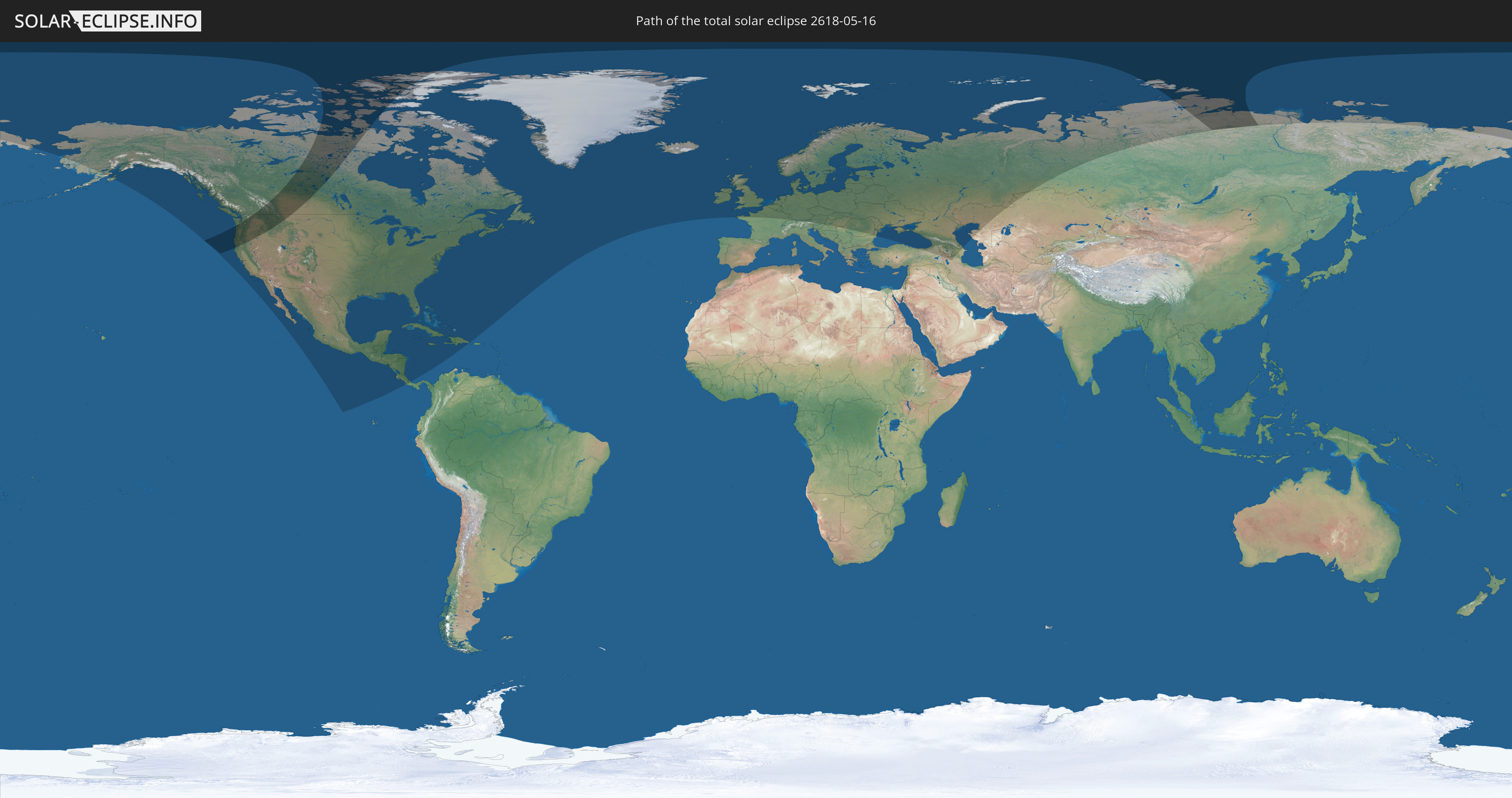
Die Sonnenfinsternis am 05/16/2618 kann man in 62 Ländern als partielle Sonnenfinsternis beobachten.
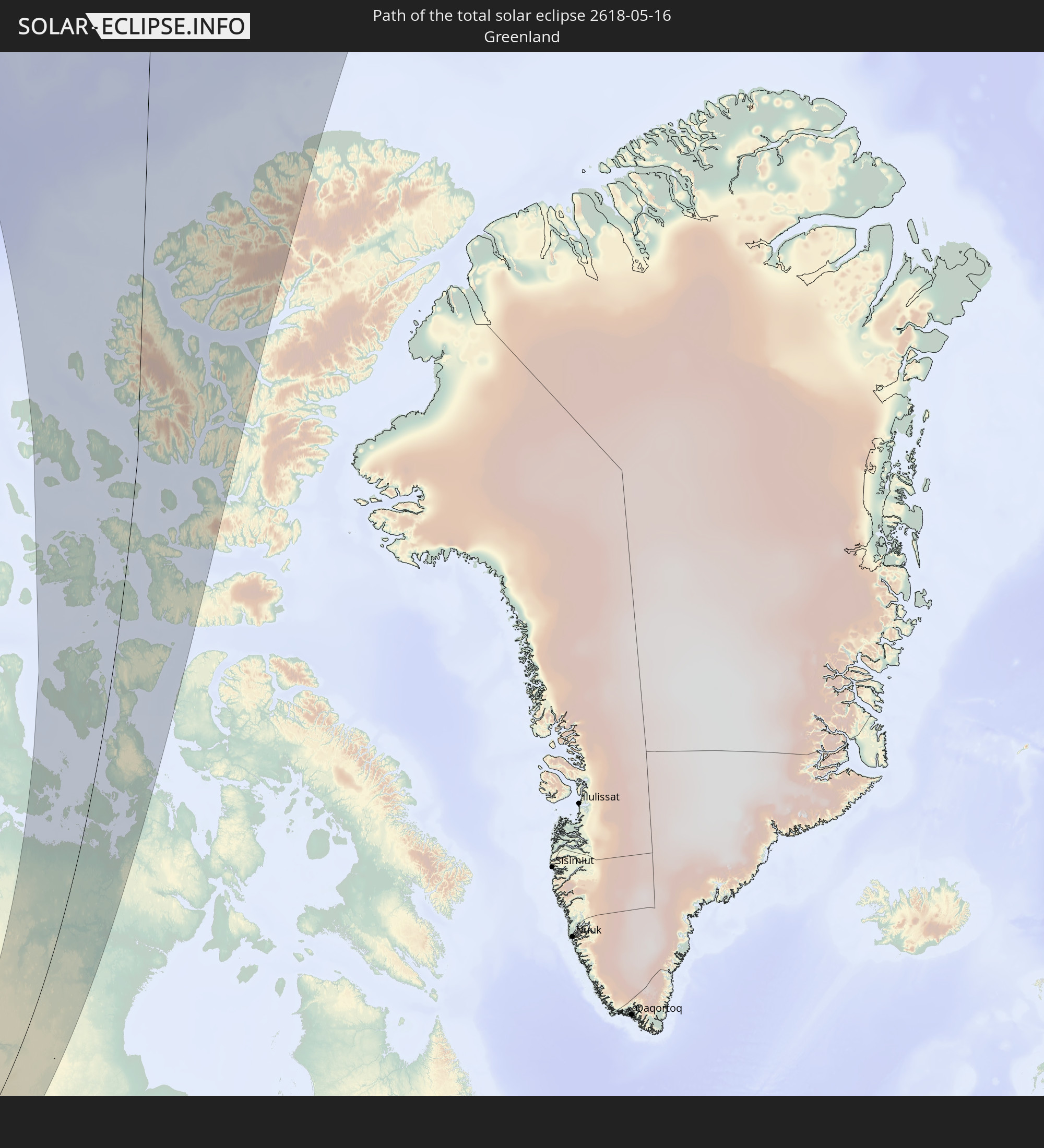
Der Finsternispfad verläuft durch 4 Länder. Nur in diesen Ländern ist sie als total Sonnenfinsternis zu sehen.
In den folgenden Ländern ist die Sonnenfinsternis total zu sehen
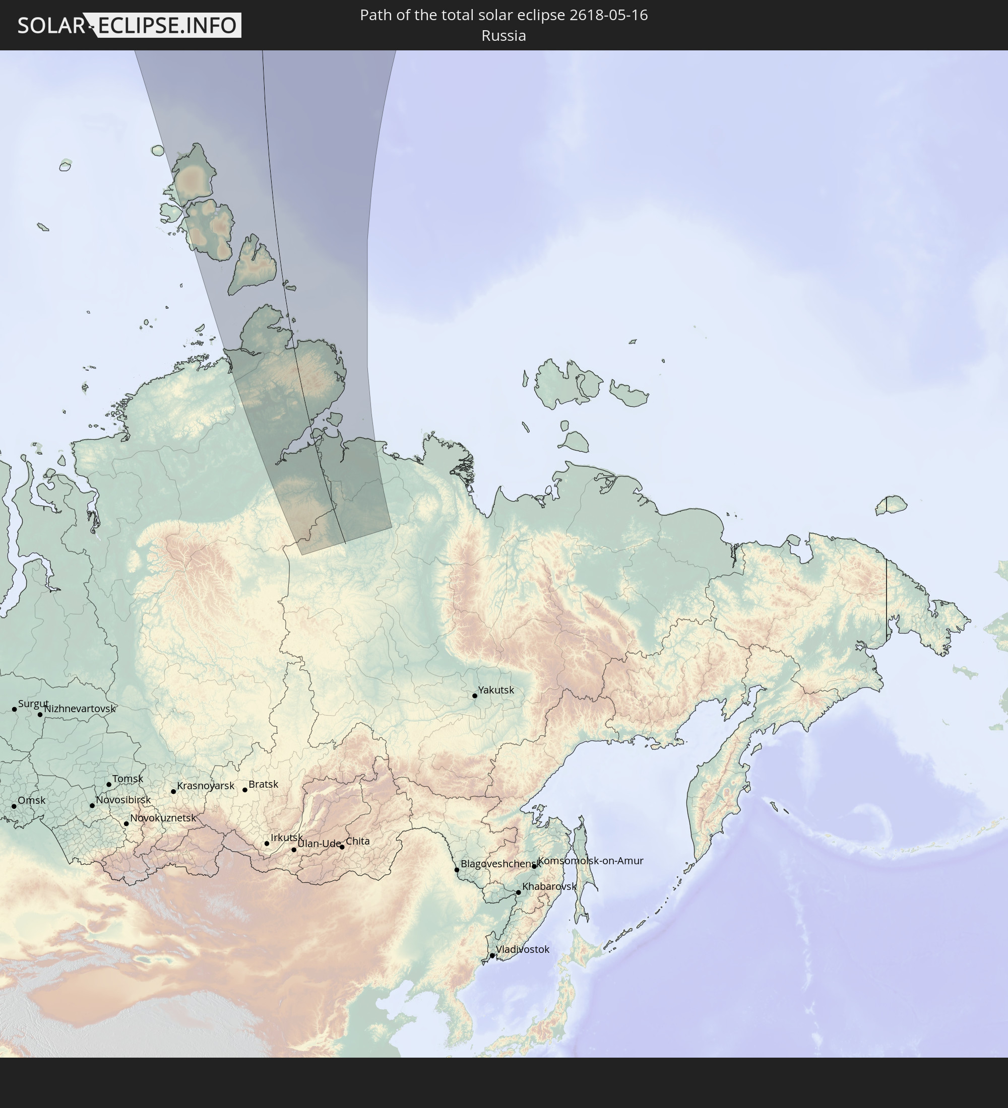 Russia
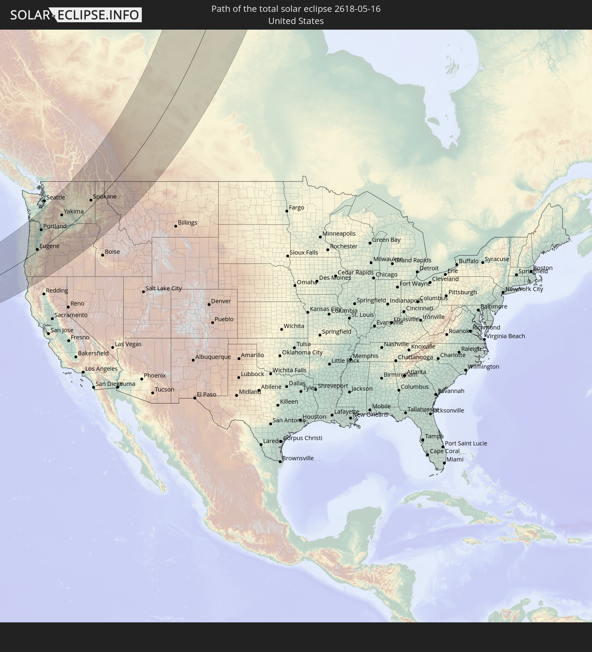 United States
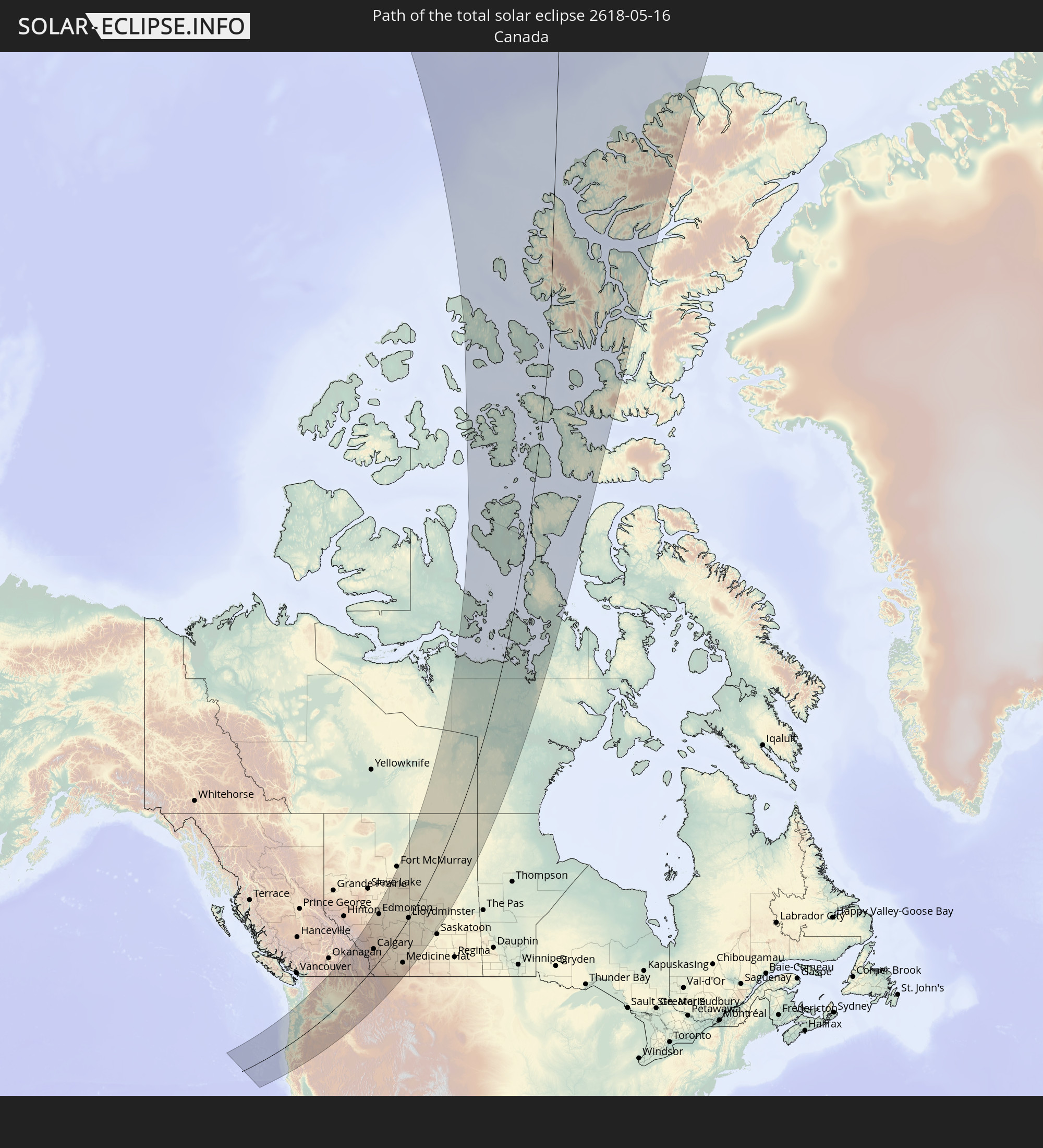 Canada
 Greenland
In den folgenden Ländern ist die Sonnenfinsternis partiell zu sehen
 Russia
 United States
 United States Minor Outlying Islands
 Canada
 Mexico
 Greenland
 Guatemala
 El Salvador
 Honduras
 Belize
 Nicaragua
 Costa Rica
 Cuba
Cuba
 Panama
 Colombia
 Cayman Islands
 The Bahamas
 Jamaica
 Haiti
Haiti
 Turks and Caicos Islands
 Dominican Republic
 Bermuda
 Saint Pierre and Miquelon
 Iceland
 Republic of Ireland
 Svalbard and Jan Mayen
 United Kingdom
 Faroe Islands
 France
 Isle of Man
 Guernsey
 Jersey
 Belgium
 Netherlands
 Norway
 Luxembourg
 Germany
 Switzerland
 Denmark
 Austria
 Sweden
 Czechia
 Slovenia
 Poland
 Hungary
 Slovakia
 Serbia
 Åland Islands
 Romania
 Finland
 Lithuania
 Latvia
 Estonia
 Ukraine
 Belarus
 Turkey
 Moldova
 Georgia
 Armenia
 Iran
Iran
 Azerbaijan
 Kazakhstan
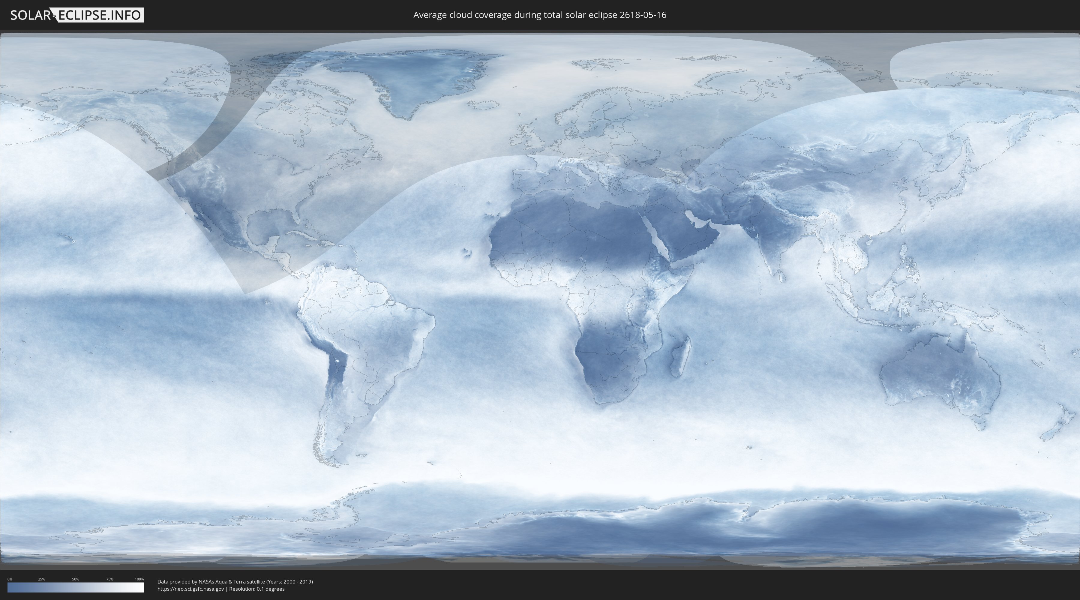
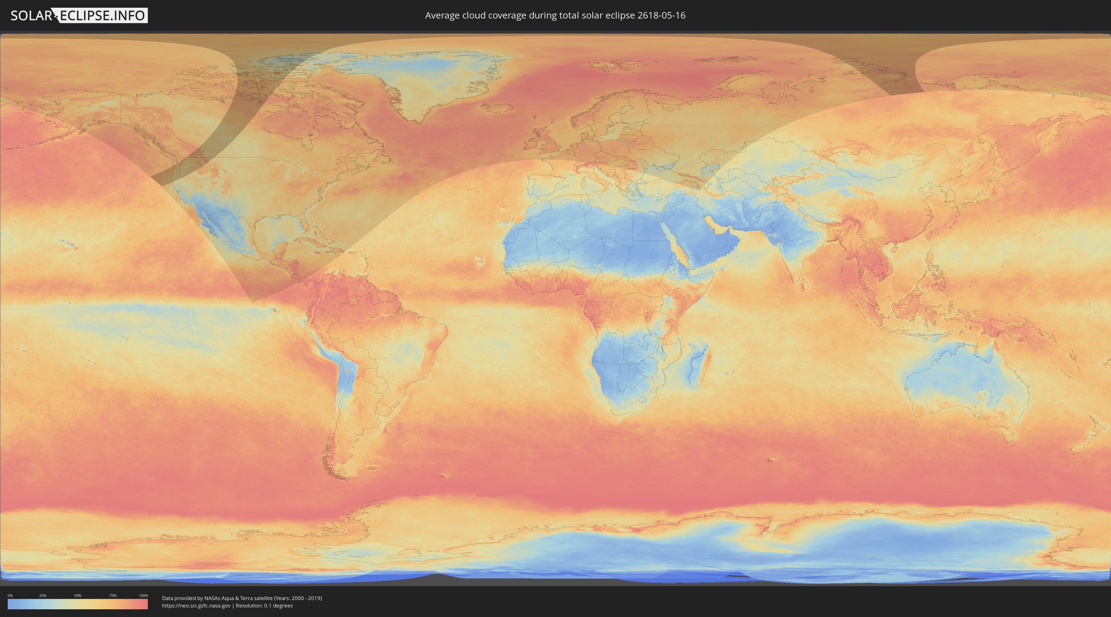
How will be the weather during the total solar eclipse on 05/16/2618?
Where is the best place to see the total solar eclipse of 05/16/2618?
The following maps show the average cloud coverage for the day of the total solar eclipse.
With the help of these maps, it is possible to find the place along the eclipse path, which has the best
chance of a cloudless sky.
Nevertheless, you should consider local circumstances and inform about the weather of your chosen
observation site.
The data is provided by NASAs satellites
AQUA and TERRA.
The cloud maps are averaged over a period of 19 years (2000 - 2019).
Detailed country maps
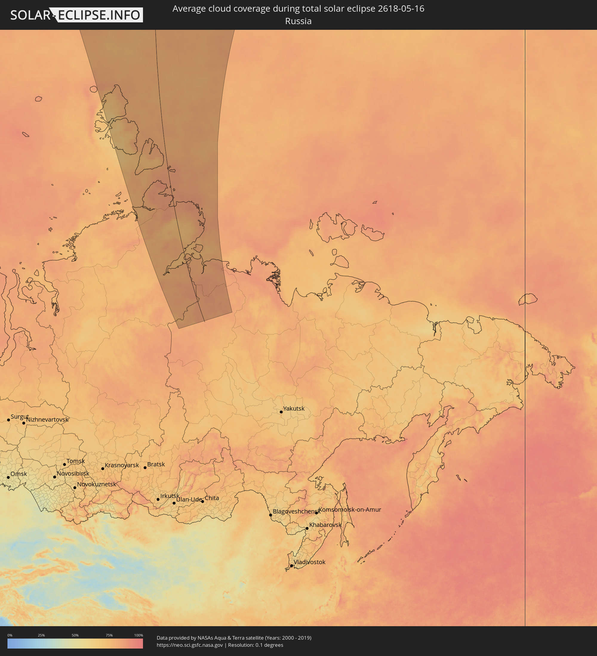 Russia
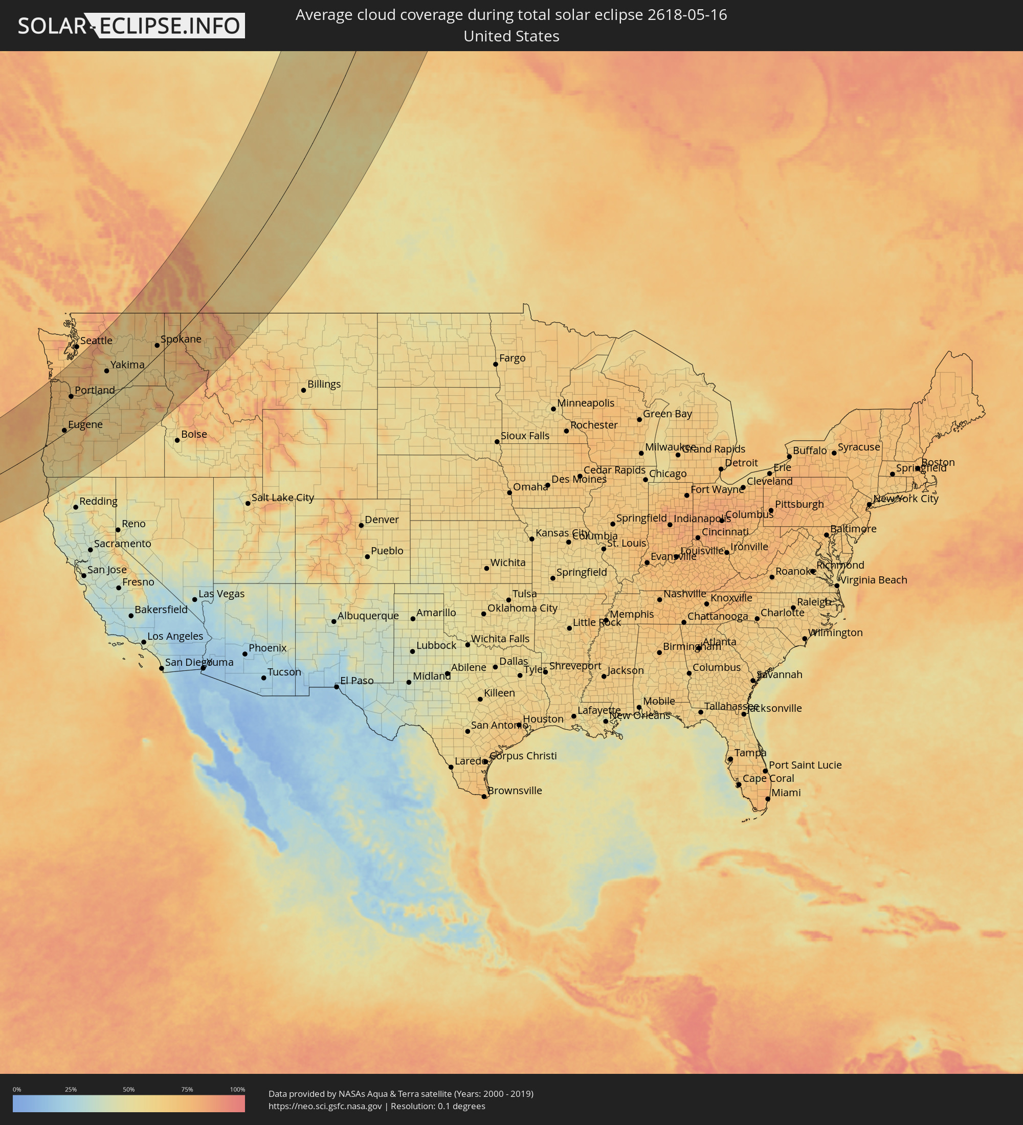 United States
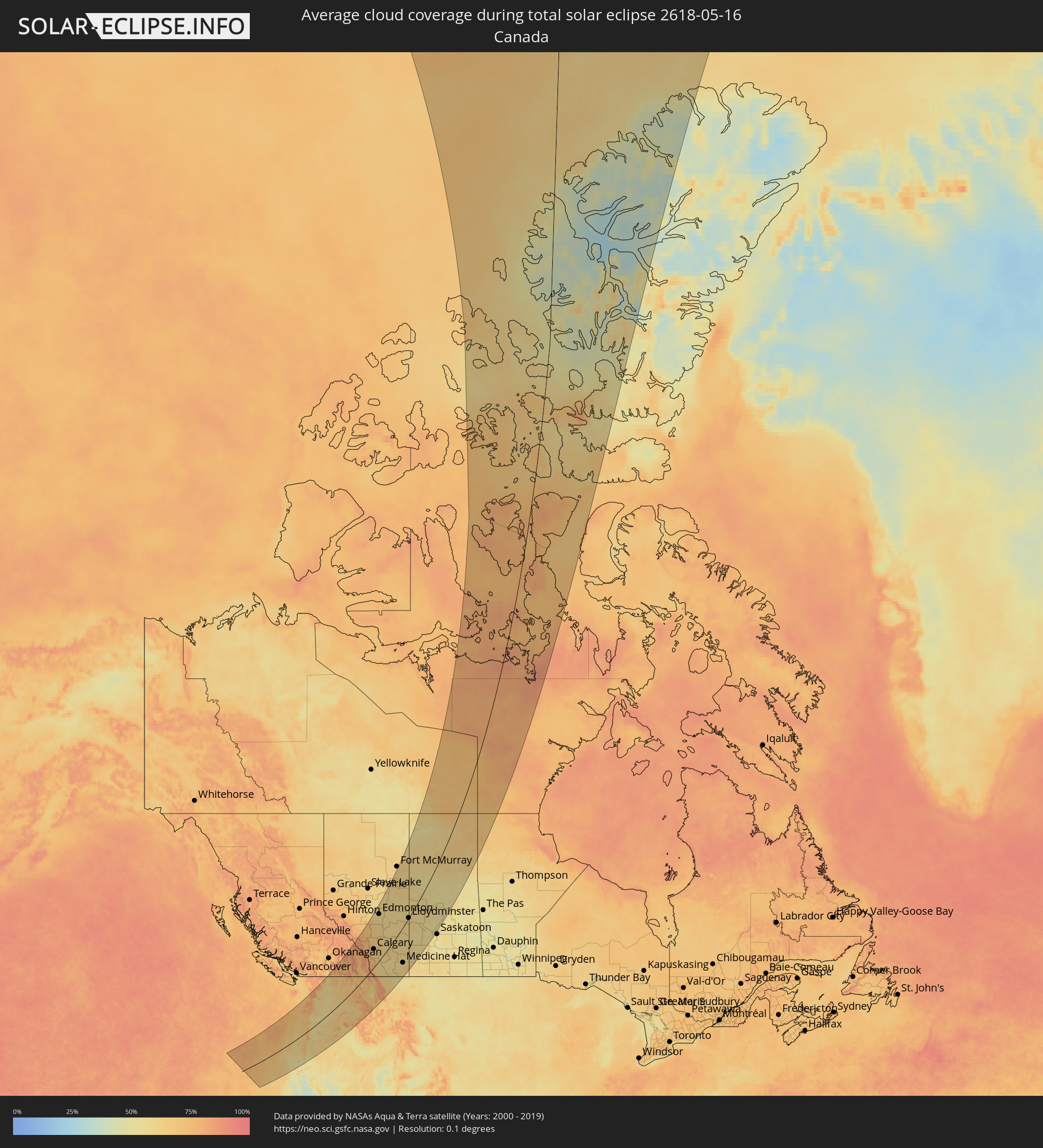 Canada
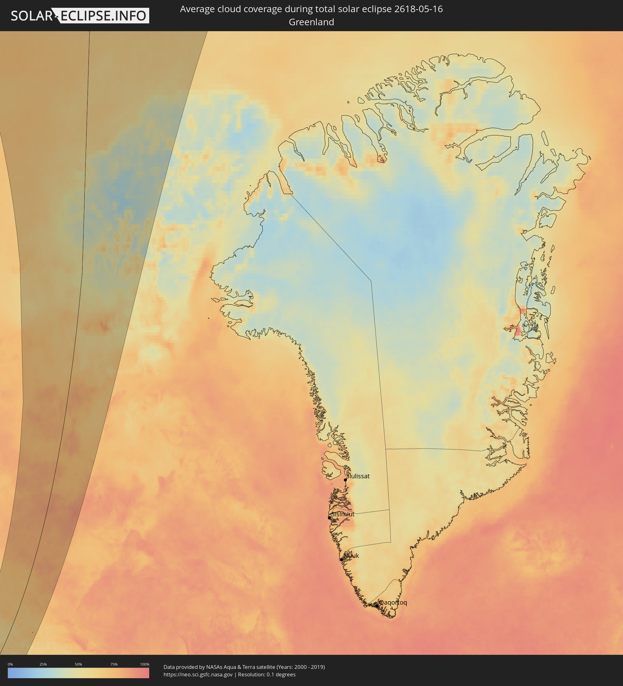 Greenland
Cities inside the path of the eclipse
The following table shows all locations with a population of more than 5,000 inside the eclipse path. Cities which have more than 100,000 inhabitants are marked bold. A click at the locations opens a detailed map.
| City | Type | Eclipse duration | Local time of max. eclipse | Distance to central line | Ø Cloud coverage |
|
North Bend, Oregon
|
total | - | 05:25:48 UTC-08:00 | 1 km | 62% |
|
Coos Bay, Oregon
|
total | - | 05:25:44 UTC-08:00 | 3 km | 62% |
|
Crescent City, California
|
total | - | 05:23:29 UTC-08:00 | 155 km | 63% |
|
Florence, Oregon
|
total | - | 05:26:34 UTC-08:00 | 49 km | 65% |
|
Newport, Oregon
|
total | - | 05:27:29 UTC-08:00 | 107 km | 66% |
|
Lincoln City, Oregon
|
total | - | 05:27:56 UTC-08:00 | 134 km | 70% |
|
Astoria, Oregon
|
total | - | 05:29:40 UTC-08:00 | 235 km | 71% |
|
Green, Oregon
|
total | - | 05:25:08 UTC-08:00 | 60 km | 58% |
|
Roseburg, Oregon
|
total | - | 05:25:12 UTC-08:00 | 56 km | 60% |
|
Grants Pass, Oregon
|
total | - | 05:24:06 UTC-08:00 | 129 km | 54% |
|
Dallas, Oregon
|
total | - | 05:27:38 UTC-08:00 | 98 km | 66% |
|
Sutherlin, Oregon
|
total | - | 05:25:26 UTC-08:00 | 41 km | 59% |
|
Corvallis, Oregon
|
total | - | 05:27:06 UTC-08:00 | 64 km | 63% |
|
Monmouth, Oregon
|
total | - | 05:27:30 UTC-08:00 | 88 km | 64% |
|
McMinnville, Oregon
|
total | - | 05:28:01 UTC-08:00 | 119 km | 66% |
|
Independence, Oregon
|
total | - | 05:27:30 UTC-08:00 | 86 km | 65% |
|
Eugene, Oregon
|
total | - | 05:26:18 UTC-08:00 | 9 km | 63% |
|
Cornelius, Oregon
|
total | - | 05:28:25 UTC-08:00 | 139 km | 67% |
|
Cottage Grove, Oregon
|
total | - | 05:25:56 UTC-08:00 | 15 km | 61% |
|
Salem, Oregon
|
total | - | 05:27:34 UTC-08:00 | 87 km | 66% |
|
Hillsboro, Oregon
|
total | - | 05:28:24 UTC-08:00 | 136 km | 69% |
|
Newberg, Oregon
|
total | - | 05:28:04 UTC-08:00 | 116 km | 66% |
|
Chehalis, Washington
|
total | - | 05:30:05 UTC-08:00 | 234 km | 71% |
|
Centralia, Washington
|
total | - | 05:30:09 UTC-08:00 | 238 km | 71% |
|
Longview, Washington
|
total | - | 05:29:18 UTC-08:00 | 188 km | 68% |
|
Lebanon, Oregon
|
total | - | 05:26:56 UTC-08:00 | 45 km | 65% |
|
Rockcreek, Oregon
|
total | - | 05:28:24 UTC-08:00 | 133 km | 71% |
|
Medford, Oregon
|
total | - | 05:23:46 UTC-08:00 | 160 km | 55% |
|
White City, Oregon
|
total | - | 05:23:55 UTC-08:00 | 150 km | 53% |
|
Woodburn, Oregon
|
total | - | 05:27:48 UTC-08:00 | 96 km | 65% |
|
Oak Hills, Oregon
|
total | - | 05:28:23 UTC-08:00 | 131 km | 70% |
|
Saint Helens, Oregon
|
total | - | 05:28:51 UTC-08:00 | 158 km | 66% |
|
Eagle Point, Oregon
|
total | - | 05:23:57 UTC-08:00 | 149 km | 50% |
|
Cedar Hills, Oregon
|
total | - | 05:28:19 UTC-08:00 | 126 km | 70% |
|
Stayton, Oregon
|
total | - | 05:27:17 UTC-08:00 | 63 km | 65% |
|
Silverton, Oregon
|
total | - | 05:27:35 UTC-08:00 | 81 km | 65% |
|
West Haven-Sylvan, Oregon
|
total | - | 05:28:19 UTC-08:00 | 125 km | 70% |
|
Sweet Home, Oregon
|
total | - | 05:26:41 UTC-08:00 | 24 km | 63% |
|
Ashland, Oregon
|
total | - | 05:23:31 UTC-08:00 | 179 km | 56% |
|
Felida, Washington
|
total | - | 05:28:35 UTC-08:00 | 139 km | 66% |
|
Portland, Oregon
|
total | - | 05:28:18 UTC-08:00 | 121 km | 68% |
|
Salmon Creek, Washington
|
total | - | 05:28:34 UTC-08:00 | 137 km | 68% |
|
Minnehaha, Washington
|
total | - | 05:28:30 UTC-08:00 | 132 km | 68% |
|
Yreka, California
|
total | - | 05:22:50 UTC-08:00 | 226 km | 47% |
|
Mount Vista, Washington
|
total | - | 05:28:36 UTC-08:00 | 138 km | 68% |
|
Jennings Lodge, Oregon
|
total | - | 05:28:05 UTC-08:00 | 107 km | 67% |
|
Oregon City, Oregon
|
total | - | 05:28:02 UTC-08:00 | 103 km | 67% |
|
Walnut Grove, Washington
|
total | - | 05:28:29 UTC-08:00 | 130 km | 68% |
|
Gladstone, Oregon
|
total | - | 05:28:04 UTC-08:00 | 105 km | 67% |
|
Molalla, Oregon
|
total | - | 05:27:43 UTC-08:00 | 84 km | 67% |
|
Mill Plain, Washington
|
total | - | 05:28:25 UTC-08:00 | 123 km | 67% |
|
Damascus, Oregon
|
total | - | 05:28:05 UTC-08:00 | 102 km | 69% |
|
Fairview, Oregon
|
total | - | 05:28:15 UTC-08:00 | 111 km | 69% |
|
Gresham, Oregon
|
total | - | 05:28:11 UTC-08:00 | 107 km | 69% |
|
Summit, Washington
|
total | - | 05:30:38 UTC-08:00 | 247 km | 69% |
|
South Hill, Washington
|
total | - | 05:30:35 UTC-08:00 | 241 km | 69% |
|
Sandy, Oregon
|
total | - | 05:27:59 UTC-08:00 | 90 km | 70% |
|
Sumner, Washington
|
total | - | 05:30:40 UTC-08:00 | 244 km | 69% |
|
Prairie Ridge, Washington
|
total | - | 05:30:32 UTC-08:00 | 234 km | 69% |
|
Lake Morton-Berrydale, Washington
|
total | - | 05:30:49 UTC-08:00 | 248 km | 68% |
|
Enumclaw, Washington
|
total | - | 05:30:35 UTC-08:00 | 232 km | 72% |
|
Klamath Falls, Oregon
|
total | - | 05:23:13 UTC-08:00 | 219 km | 51% |
|
Hood River, Oregon
|
total | - | 05:28:12 UTC-08:00 | 81 km | 60% |
|
Bend, Oregon
|
total | - | 05:25:42 UTC-08:00 | 73 km | 57% |
|
The Dalles, Oregon
|
total | - | 05:27:56 UTC-08:00 | 55 km | 53% |
|
Redmond, Oregon
|
total | - | 05:25:58 UTC-08:00 | 61 km | 56% |
|
Prineville, Oregon
|
total | - | 05:25:54 UTC-08:00 | 75 km | 55% |
|
Ellensburg, Washington
|
total | - | 05:29:51 UTC-08:00 | 142 km | 59% |
|
Yakima, Washington
|
total | - | 05:29:15 UTC-08:00 | 107 km | 59% |
|
Wenatchee, Washington
|
total | - | 05:30:26 UTC-08:00 | 165 km | 61% |
|
Toppenish, Washington
|
total | - | 05:28:51 UTC-08:00 | 78 km | 58% |
|
East Wenatchee Bench, Washington
|
total | - | 05:30:26 UTC-08:00 | 163 km | 61% |
|
Sunnyside, Washington
|
total | - | 05:28:41 UTC-08:00 | 58 km | 56% |
|
Grandview, Washington
|
total | - | 05:28:32 UTC-08:00 | 47 km | 56% |
|
Ephrata, Washington
|
total | - | 05:30:04 UTC-08:00 | 117 km | 56% |
|
West Richland, Washington
|
total | - | 05:28:28 UTC-08:00 | 24 km | 57% |
|
Hermiston, Oregon
|
total | - | 05:27:45 UTC-08:00 | 19 km | 55% |
|
Moses Lake, Washington
|
total | - | 05:29:43 UTC-08:00 | 87 km | 53% |
|
Othello, Washington
|
total | - | 05:29:13 UTC-08:00 | 57 km | 57% |
|
Kennewick, Washington
|
total | - | 05:28:16 UTC-08:00 | 5 km | 54% |
|
Pendleton, Oregon
|
total | - | 05:27:21 UTC-08:00 | 58 km | 61% |
|
College Place, Washington
|
total | - | 05:27:49 UTC-08:00 | 47 km | 63% |
|
Walla Walla, Washington
|
total | - | 05:27:50 UTC-08:00 | 48 km | 62% |
|
La Grande, Oregon
|
total | - | 05:26:38 UTC-08:00 | 123 km | 64% |
|
Baker City, Oregon
|
total | - | 05:25:44 UTC-08:00 | 183 km | 59% |
|
Trail, British Columbia
|
total | - | 05:32:25 UTC-08:00 | 157 km | 66% |
|
Castlegar, British Columbia
|
total | - | 05:32:44 UTC-08:00 | 170 km | 70% |
|
Cheney, Washington
|
total | - | 05:29:51 UTC-08:00 | 26 km | 66% |
|
Spokane, Washington
|
total | - | 05:30:05 UTC-08:00 | 32 km | 67% |
|
Fairwood, Washington
|
total | - | 05:30:15 UTC-08:00 | 40 km | 67% |
|
Mead, Washington
|
total | - | 05:30:14 UTC-08:00 | 37 km | 67% |
|
Nelson, British Columbia
|
total | - | 05:32:58 UTC-08:00 | 164 km | 78% |
|
Dishman, Washington
|
total | - | 05:30:03 UTC-08:00 | 24 km | 68% |
|
Veradale, Washington
|
total | - | 05:30:01 UTC-08:00 | 20 km | 69% |
|
Pullman, Washington
|
total | - | 05:28:34 UTC-08:00 | 55 km | 63% |
|
Liberty Lake, Washington
|
total | - | 05:30:02 UTC-08:00 | 17 km | 69% |
|
Clarkston, Washington
|
total | - | 05:28:03 UTC-08:00 | 87 km | 61% |
|
Lewiston, Idaho
|
total | - | 05:28:03 UTC-08:00 | 89 km | 61% |
|
Coeur d'Alene, Idaho
|
total | - | 05:29:58 UTC-08:00 | 1 km | 67% |
|
Sandpoint, Idaho
|
total | - | 05:30:52 UTC-08:00 | 33 km | 61% |
|
Kimberley, British Columbia
|
total | - | 06:32:59 UTC-07:00 | 104 km | 69% |
|
Cranbrook, British Columbia
|
total | - | 06:32:40 UTC-07:00 | 80 km | 67% |
|
Banff, Alberta
|
total | - | 06:35:22 UTC-07:00 | 185 km | 81% |
|
Canmore, Alberta
|
total | - | 06:35:11 UTC-07:00 | 167 km | 83% |
|
Fernie, British Columbia
|
total | - | 06:32:33 UTC-07:00 | 42 km | 79% |
|
Rocky Mountain House, Alberta
|
total | - | 06:37:14 UTC-07:00 | 225 km | 68% |
|
Cochrane, Alberta
|
total | - | 06:35:13 UTC-07:00 | 124 km | 71% |
|
Kalispell, Montana
|
total | - | 06:30:18 UTC-07:00 | 96 km | 63% |
|
Evergreen, Montana
|
total | - | 06:30:21 UTC-07:00 | 95 km | 63% |
|
Olds, Alberta
|
total | - | 06:36:09 UTC-07:00 | 142 km | 65% |
|
Sylvan Lake, Alberta
|
total | - | 06:37:03 UTC-07:00 | 174 km | 65% |
|
Calgary, Alberta
|
total | - | 06:34:56 UTC-07:00 | 93 km | 69% |
|
Airdrie, Alberta
|
total | - | 06:35:21 UTC-07:00 | 107 km | 67% |
|
Stony Plain, Alberta
|
total | - | 06:39:05 UTC-07:00 | 242 km | 57% |
|
Missoula, Montana
|
total | - | 06:28:08 UTC-07:00 | 214 km | 63% |
|
Okotoks, Alberta
|
total | - | 06:34:23 UTC-07:00 | 66 km | 67% |
|
Spruce Grove, Alberta
|
total | - | 06:39:04 UTC-07:00 | 237 km | 58% |
|
High River, Alberta
|
total | - | 06:34:08 UTC-07:00 | 50 km | 67% |
|
Red Deer, Alberta
|
total | - | 06:36:56 UTC-07:00 | 155 km | 64% |
|
Devon, Alberta
|
total | - | 06:38:46 UTC-07:00 | 217 km | 59% |
|
Lacombe, Alberta
|
total | - | 06:37:15 UTC-07:00 | 164 km | 62% |
|
Morinville, Alberta
|
total | - | 06:39:29 UTC-07:00 | 237 km | 56% |
|
St. Albert, Alberta
|
total | - | 06:39:12 UTC-07:00 | 227 km | 59% |
|
Ponoka, Alberta
|
total | - | 06:37:35 UTC-07:00 | 168 km | 62% |
|
Leduc, Alberta
|
total | - | 06:38:35 UTC-07:00 | 201 km | 57% |
|
Edmonton, Alberta
|
total | - | 06:39:03 UTC-07:00 | 213 km | 58% |
|
Beaumont, Alberta
|
total | - | 06:38:42 UTC-07:00 | 198 km | 58% |
|
Strathmore, Alberta
|
total | - | 06:34:51 UTC-07:00 | 54 km | 61% |
|
Silver Berry, Alberta
|
total | - | 06:38:53 UTC-07:00 | 202 km | 58% |
|
Wild Rose, Alberta
|
total | - | 06:38:54 UTC-07:00 | 203 km | 58% |
|
Wetaskiwin, Alberta
|
total | - | 06:38:03 UTC-07:00 | 173 km | 60% |
|
Sherwood Park, Alberta
|
total | - | 06:38:59 UTC-07:00 | 202 km | 59% |
|
Fort Saskatchewan, Alberta
|
total | - | 06:39:18 UTC-07:00 | 208 km | 56% |
|
Camrose, Alberta
|
total | - | 06:38:05 UTC-07:00 | 146 km | 60% |
|
Lethbridge, Alberta
|
total | - | 06:32:32 UTC-07:00 | 70 km | 57% |
|
Stettler, Alberta
|
total | - | 06:36:53 UTC-07:00 | 97 km | 59% |
|
Coaldale, Alberta
|
total | - | 06:32:32 UTC-07:00 | 80 km | 56% |
|
Taber, Alberta
|
total | - | 06:32:35 UTC-07:00 | 101 km | 58% |
|
Vegreville, Alberta
|
total | - | 06:38:50 UTC-07:00 | 129 km | 58% |
|
Brooks, Alberta
|
total | - | 06:33:53 UTC-07:00 | 62 km | 58% |
|
Wainwright, Alberta
|
total | - | 06:37:36 UTC-07:00 | 22 km | 60% |
|
Bonnyville, Alberta
|
total | - | 06:40:03 UTC-07:00 | 97 km | 57% |
|
Medicine Hat, Alberta
|
total | - | 06:32:51 UTC-07:00 | 167 km | 59% |
|
Cold Lake, Alberta
|
total | - | 06:40:22 UTC-07:00 | 77 km | 56% |
|
Lloydminster, Saskatchewan
|
total | - | 06:38:19 UTC-07:00 | 1 km | 58% |
|
North Battleford, Saskatchewan
|
total | - | 07:37:22 UTC-06:00 | 126 km | 57% |