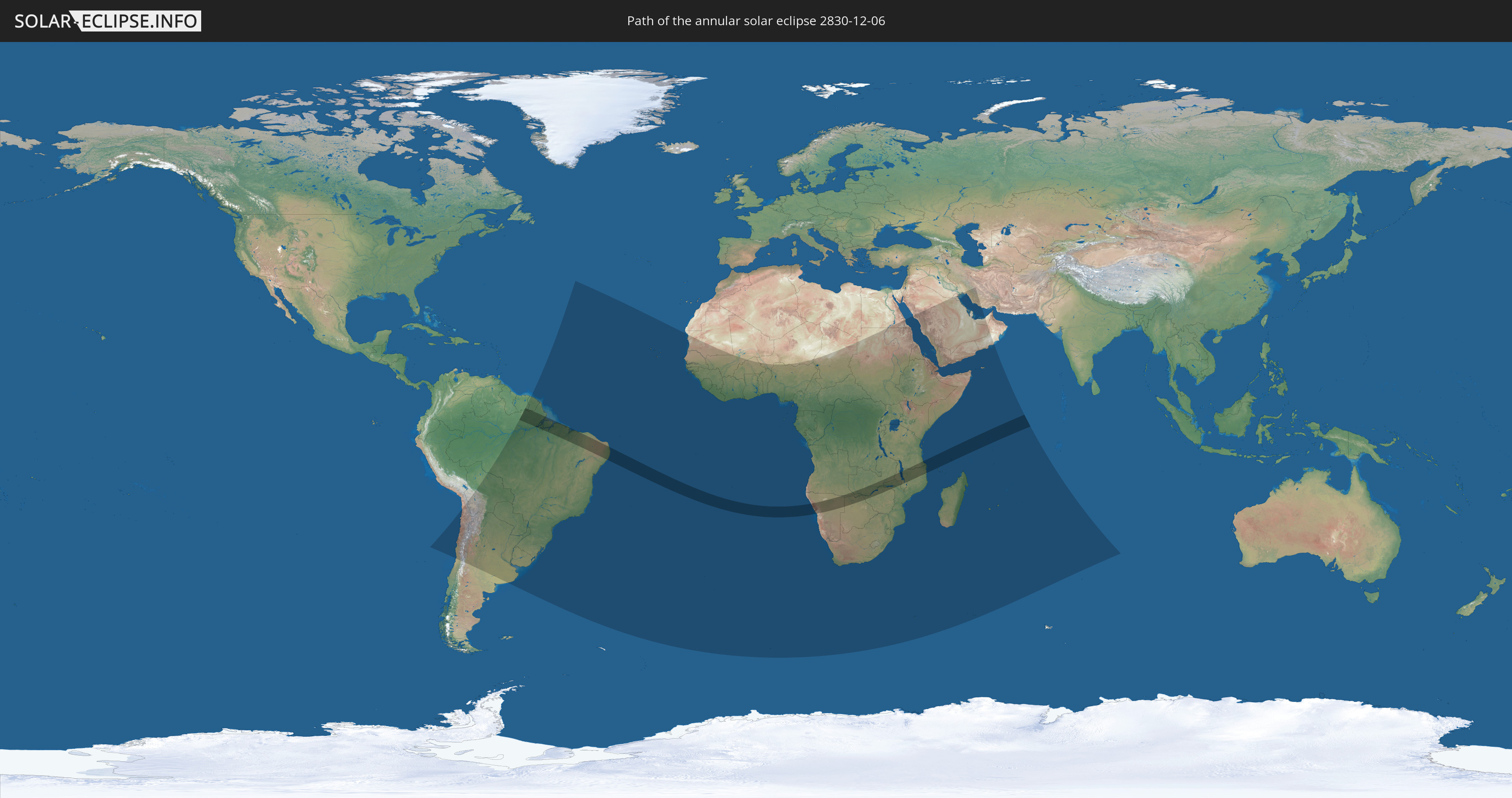
Annular solar eclipse of 12/06/2830
| Day of week: | Friday |
| Maximum duration of eclipse: | 09m57s |
| Maximum width of eclipse path: | 278 km |
| Saros cycle: | 165 |
| Coverage: | 92.6% |
| Magnitude: | 0.9261 |
| Gamma: | 0.0124 |
Wo kann man die Sonnenfinsternis vom 12/06/2830 sehen?
Die Sonnenfinsternis am 12/06/2830 kann man in 71 Ländern als partielle Sonnenfinsternis beobachten.
Der Finsternispfad verläuft durch 12 Länder. Nur in diesen Ländern ist sie als annular Sonnenfinsternis zu sehen.
In den folgenden Ländern ist die Sonnenfinsternis annular zu sehen
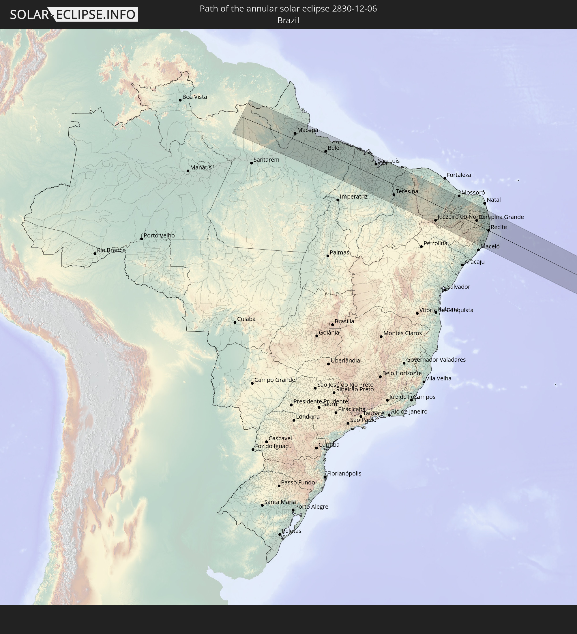 Brazil
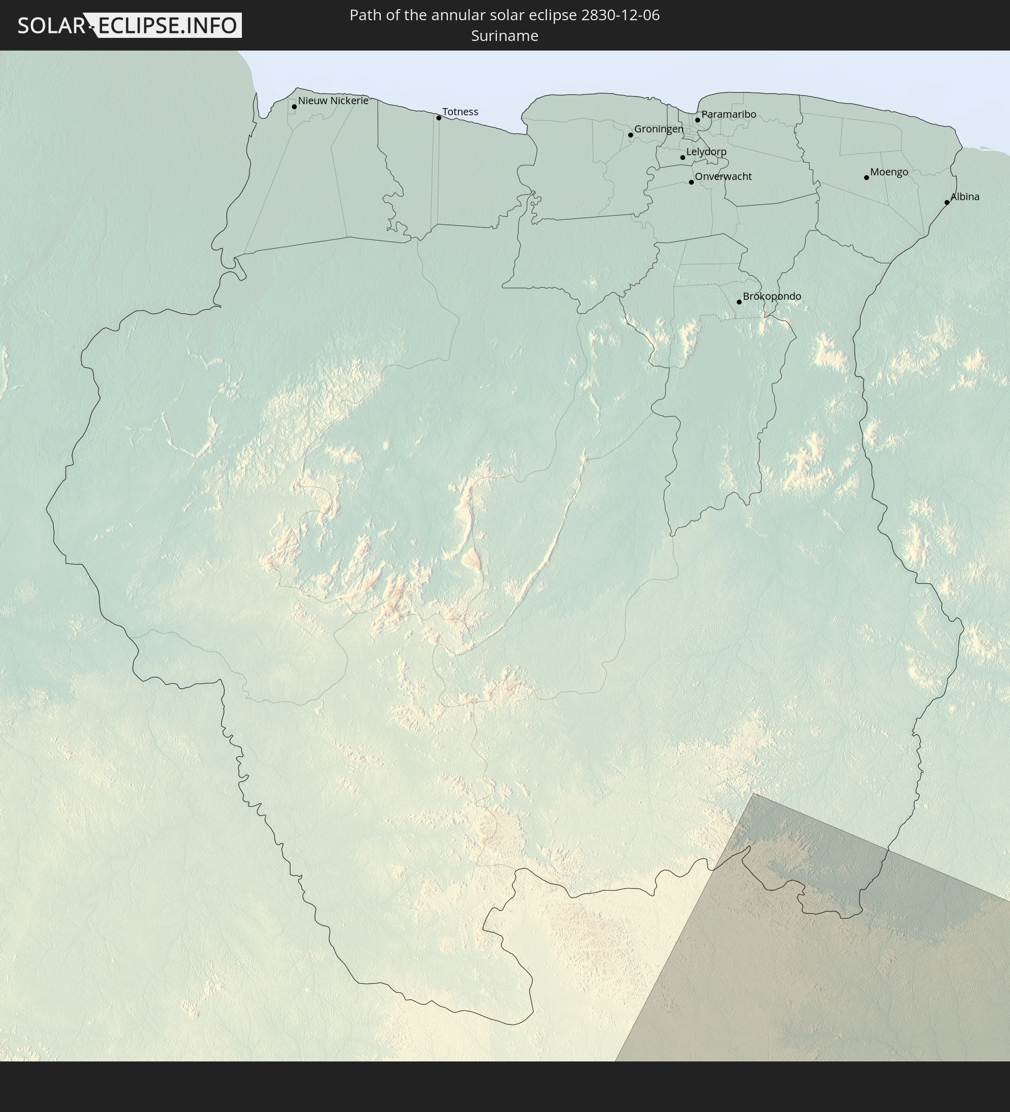 Suriname
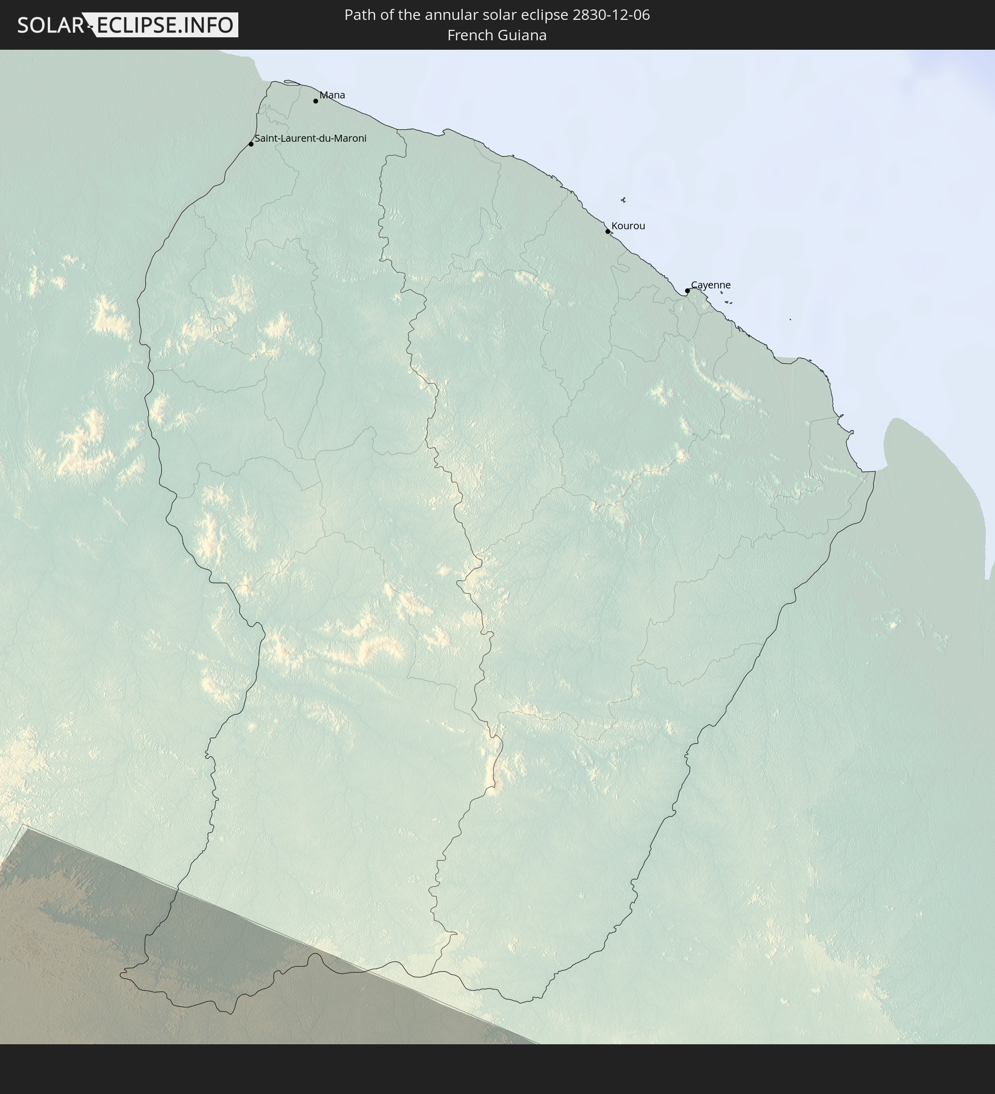 French Guiana
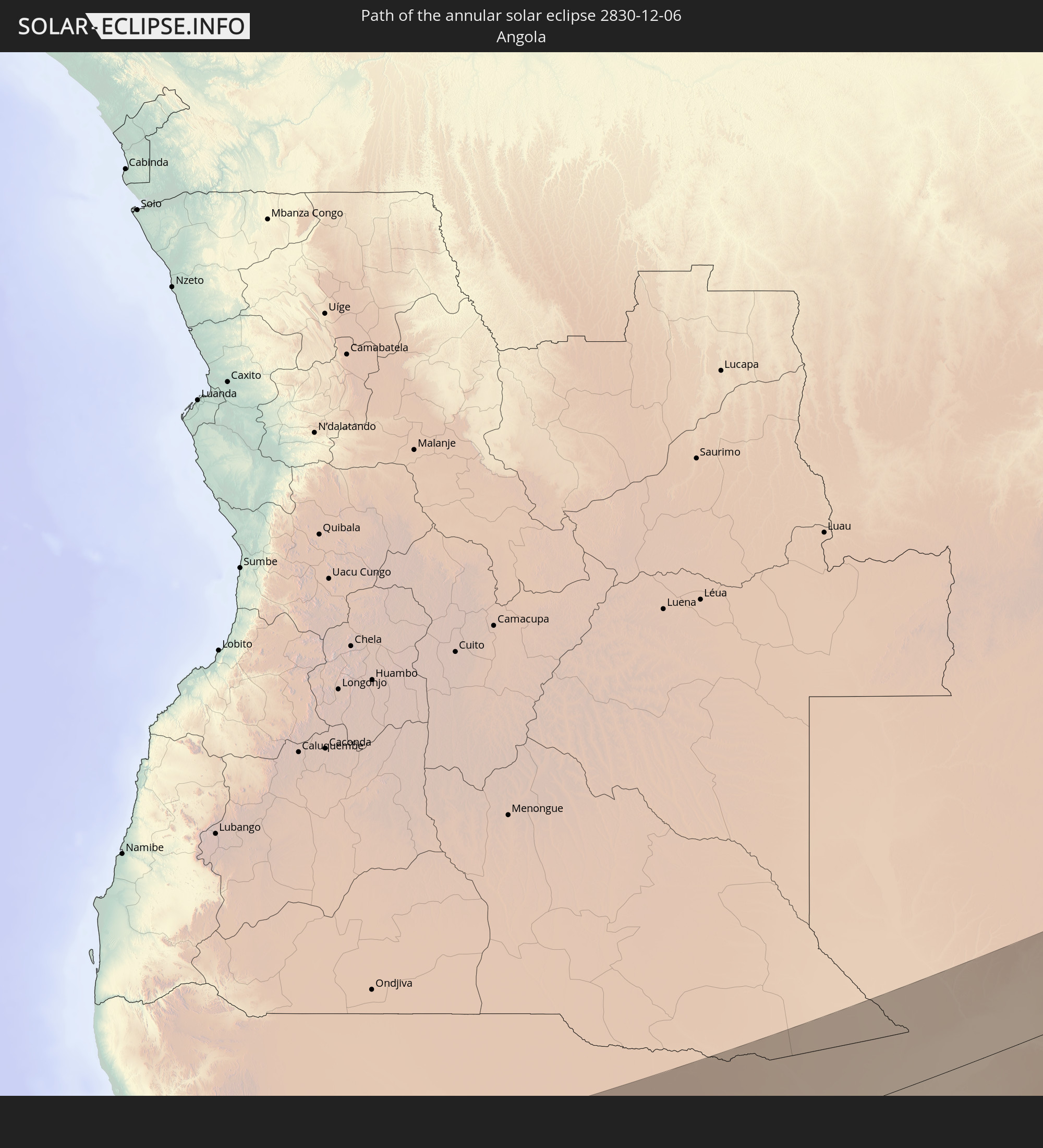 Angola
 Namibia
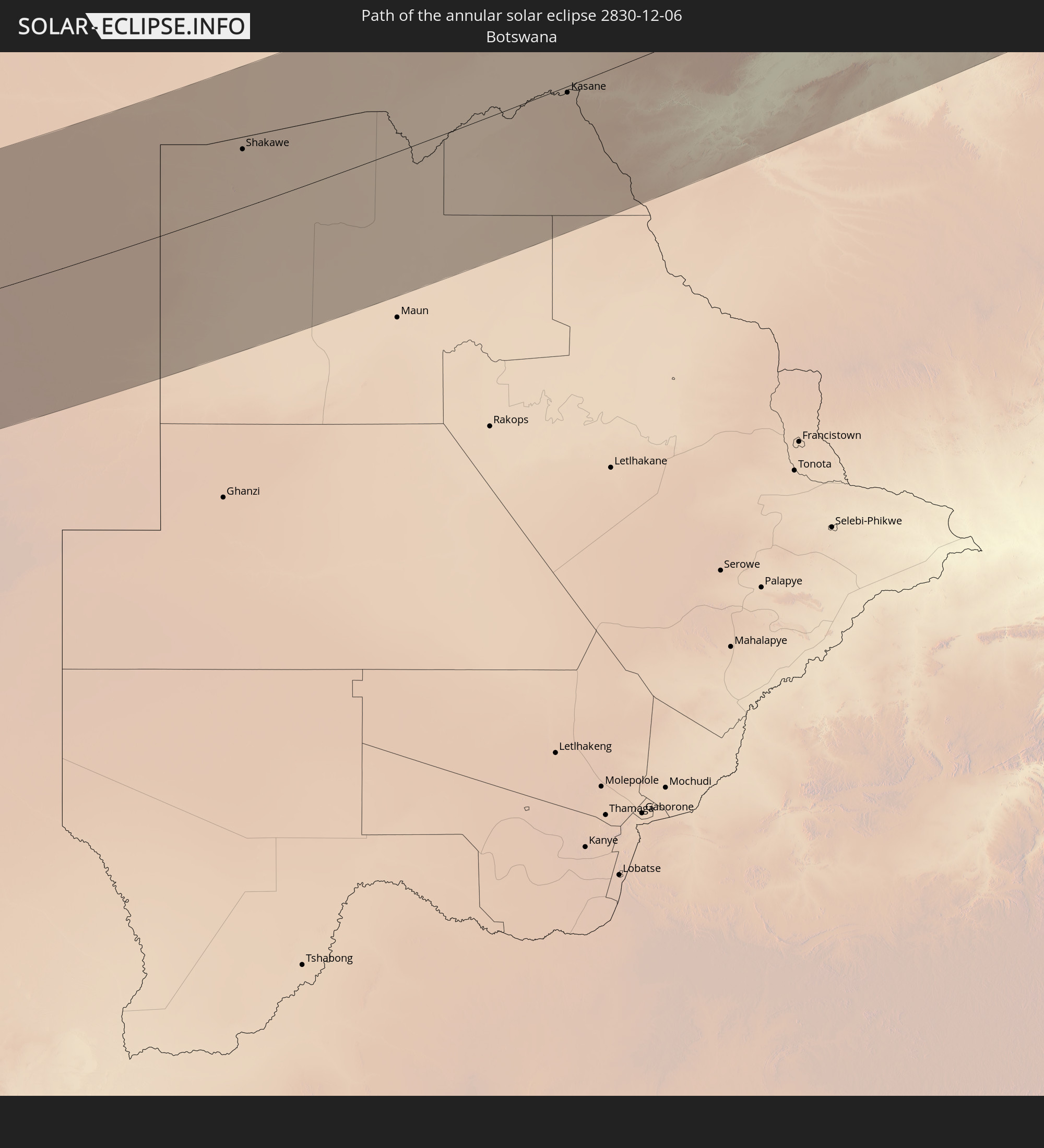 Botswana
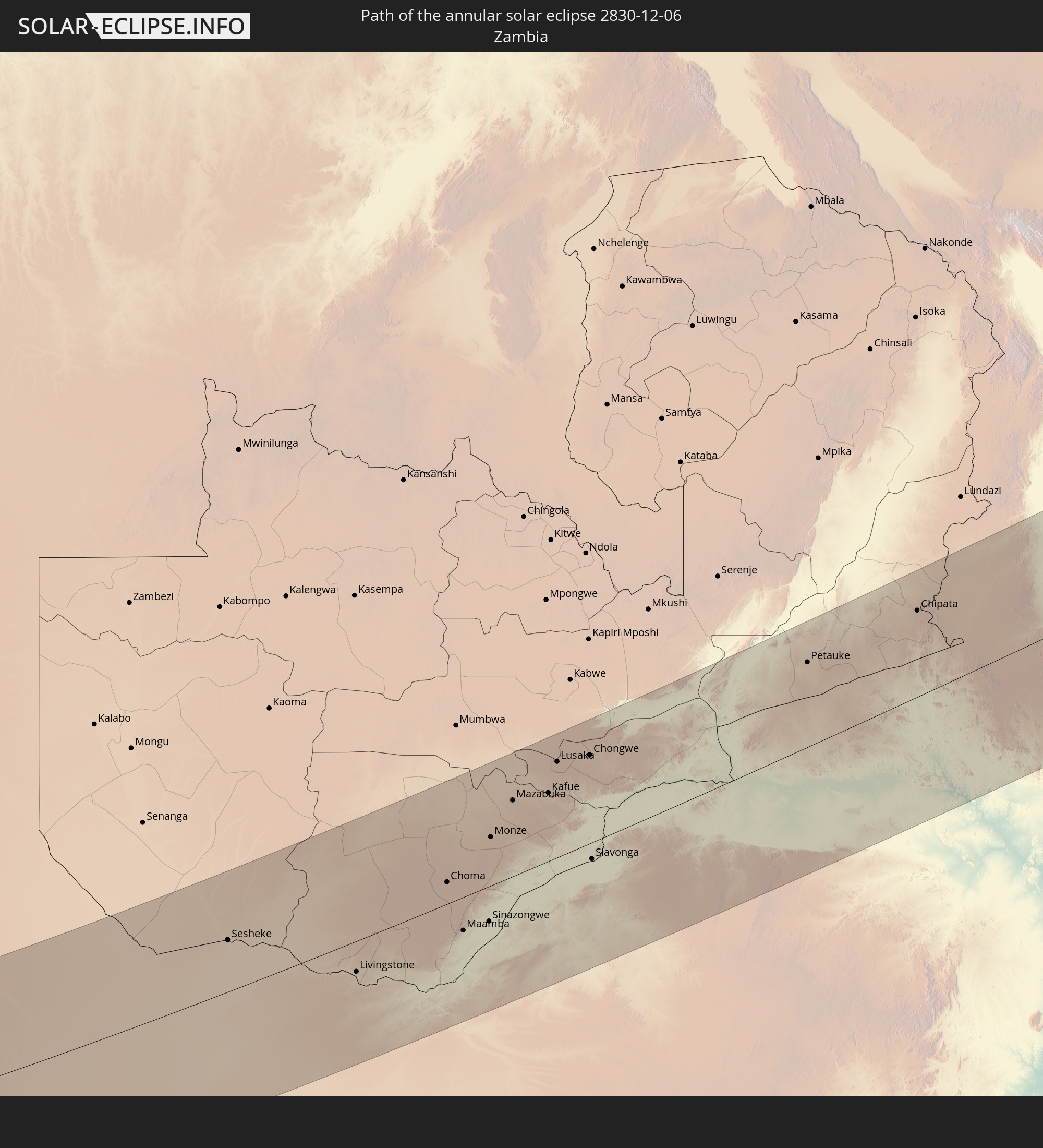 Zambia
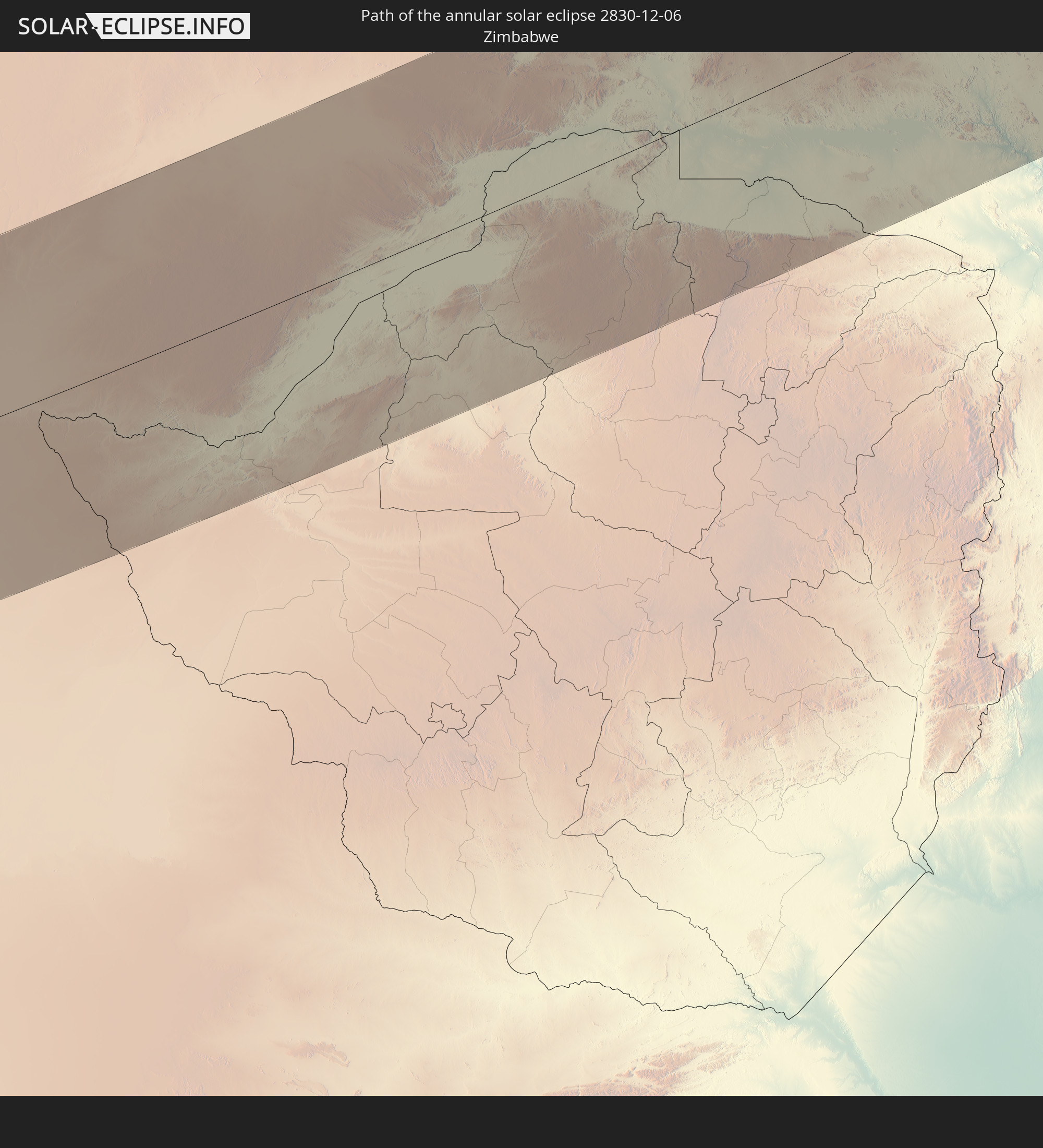 Zimbabwe
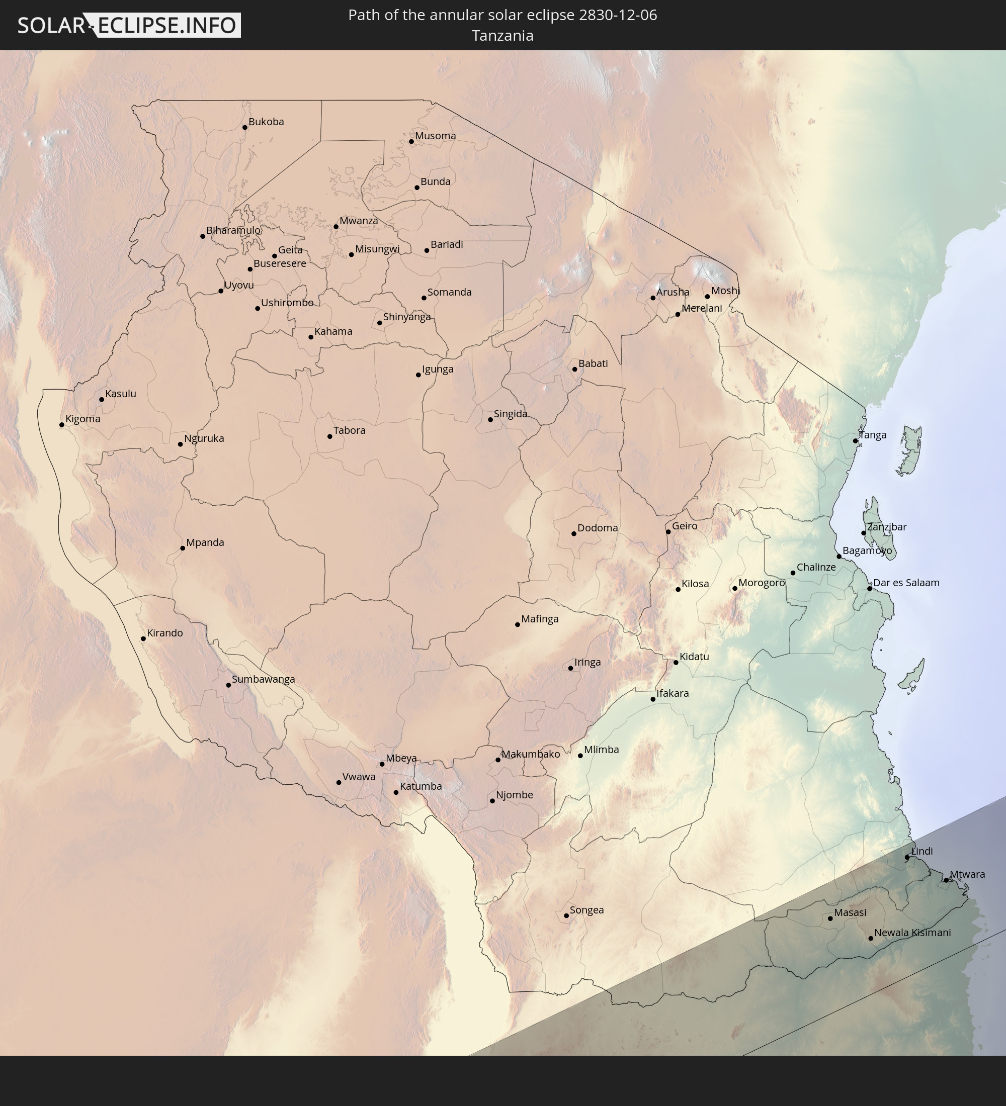 Tanzania
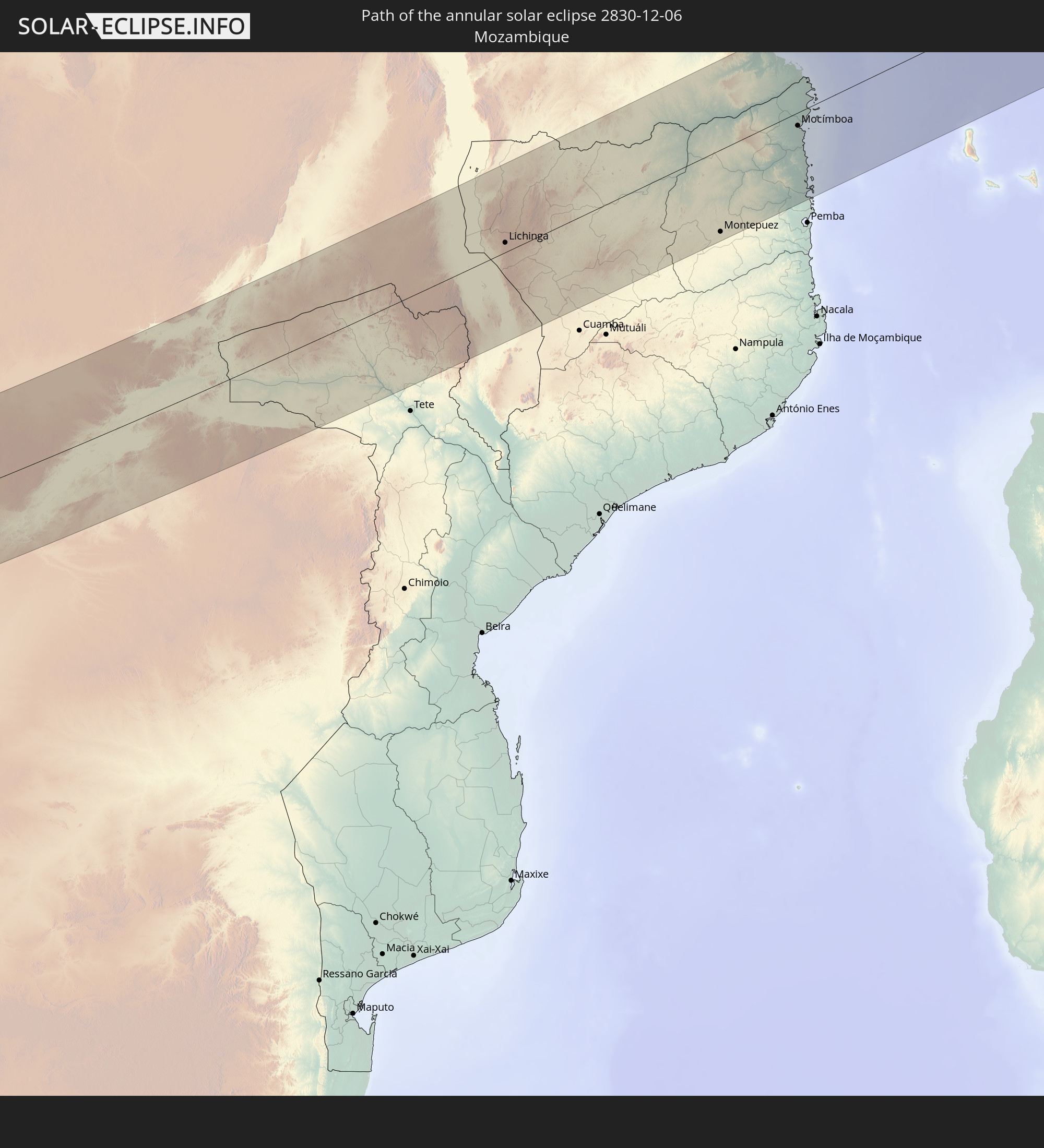 Mozambique
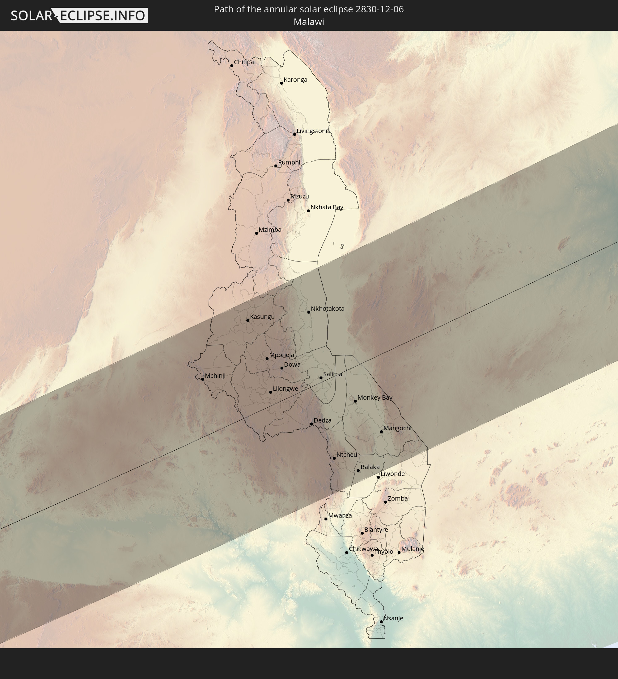 Malawi
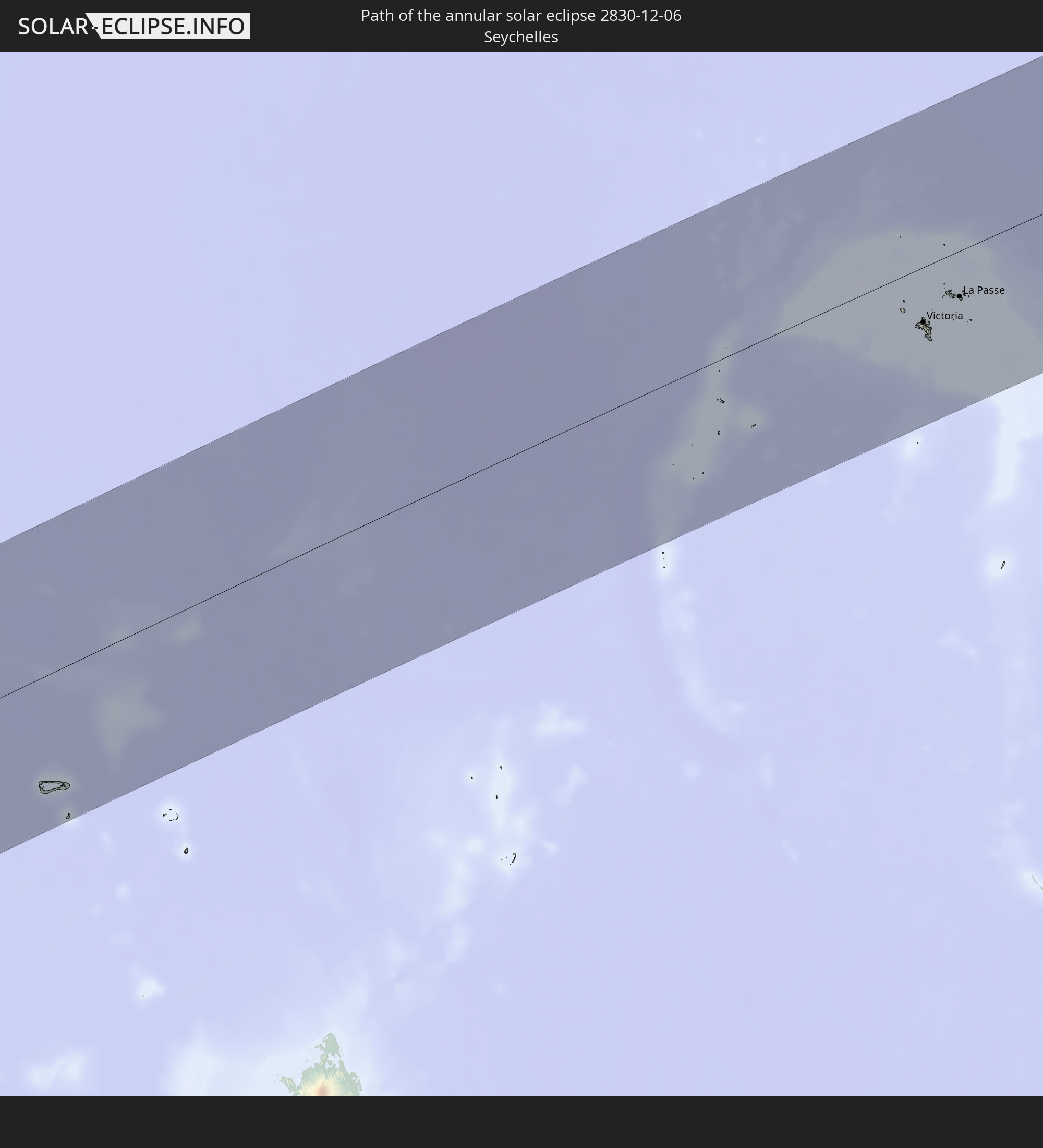 Seychelles
In den folgenden Ländern ist die Sonnenfinsternis partiell zu sehen
 Chile
Chile
 Brazil
 Argentina
 Bolivia
 Paraguay
 Uruguay
 Suriname
 French Guiana
 Cabo Verde
 Senegal
 Mauritania
 The Gambia
 Guinea-Bissau
 Guinea
 Saint Helena, Ascension and Tristan da Cunha
 Sierra Leone
 Mali
Mali
 Liberia
 Ivory Coast
 Burkina Faso
 Ghana
Ghana
 Togo
Togo
 Niger
Niger
 Benin
Benin
 Nigeria
 Bouvet Island
 Equatorial Guinea
 São Tomé and Príncipe
 Cameroon
 Gabon
Gabon
 Republic of the Congo
 Angola
 Namibia
 Democratic Republic of the Congo
 Chad
Chad
 Central African Republic
 South Africa
 Botswana
 Sudan
Sudan
 Zambia
 Egypt
Egypt
 Zimbabwe
 Lesotho
 Rwanda
 Burundi
 Tanzania
 Uganda
 Mozambique
 Swaziland
 Malawi
 Ethiopia
 Kenya
Kenya
 Saudi Arabia
 Eritrea
 Iraq
Iraq
 French Southern and Antarctic Lands
 Somalia
 Djibouti
 Yemen
Yemen
 Madagascar
 Comoros
 Iran
Iran
 Mayotte
 Seychelles
 Kuwait
 Bahrain
 Qatar
Qatar
 United Arab Emirates
 Oman
Oman
 Réunion
 Mauritius
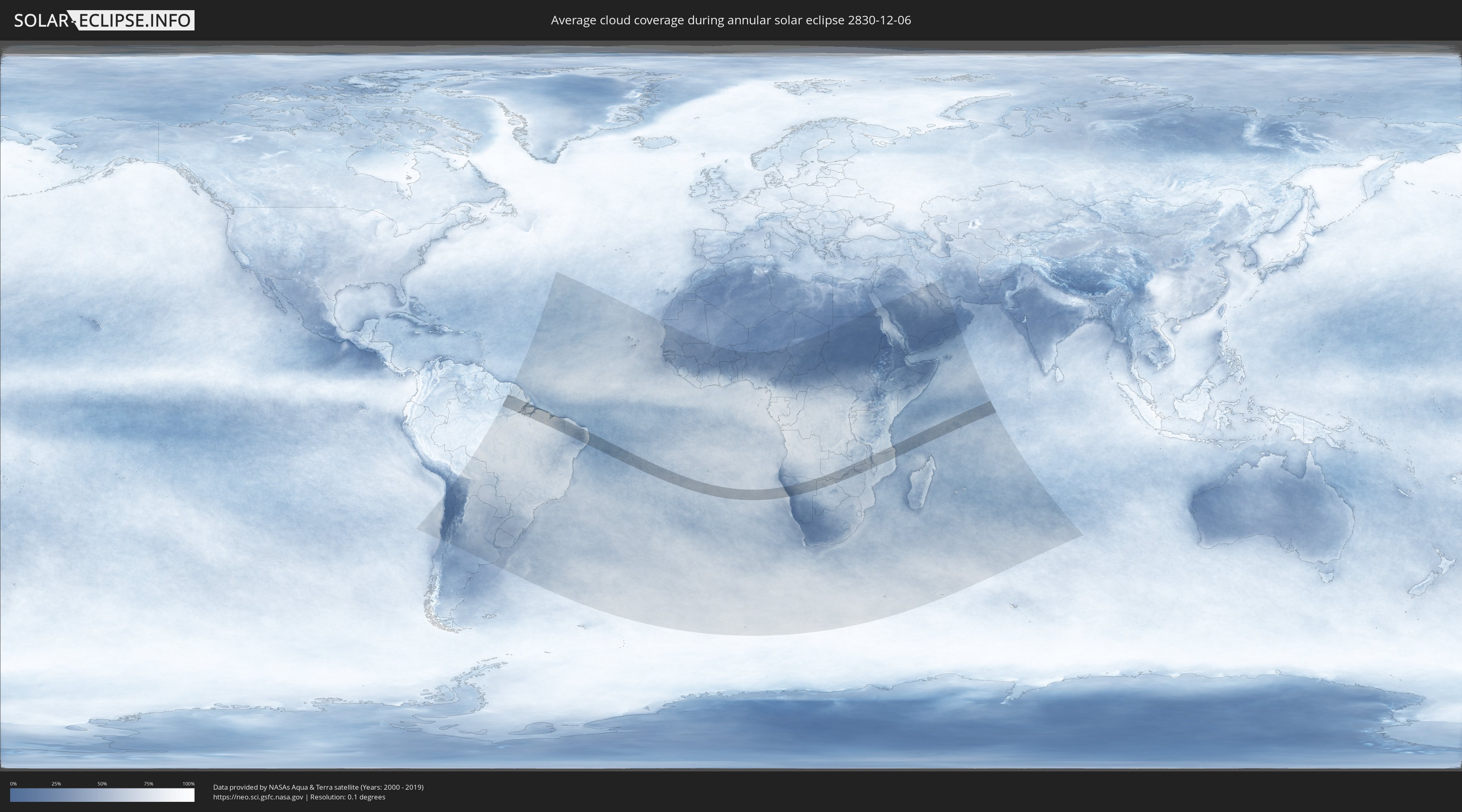
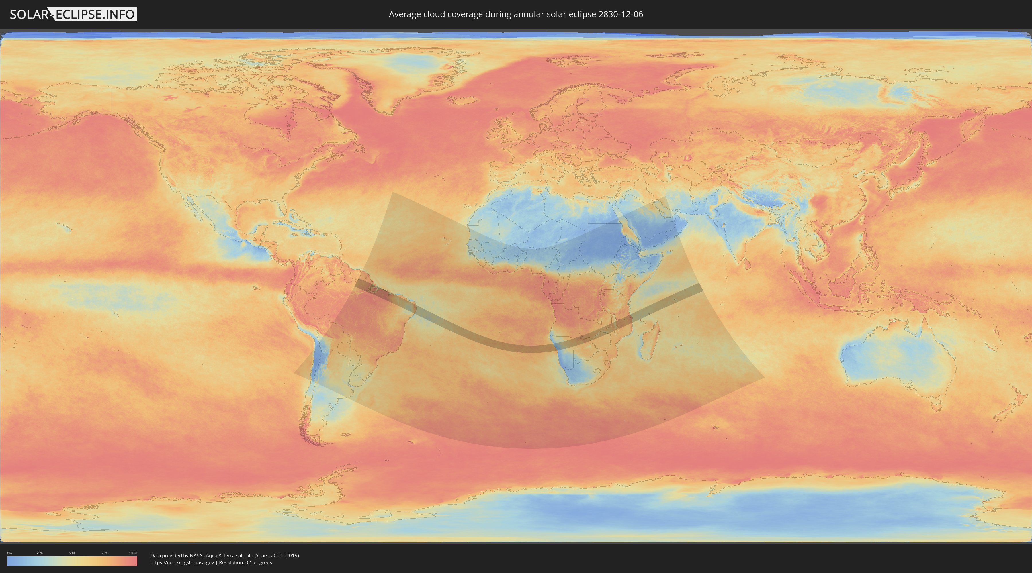
How will be the weather during the annular solar eclipse on 12/06/2830?
Where is the best place to see the annular solar eclipse of 12/06/2830?
The following maps show the average cloud coverage for the day of the annular solar eclipse.
With the help of these maps, it is possible to find the place along the eclipse path, which has the best
chance of a cloudless sky.
Nevertheless, you should consider local circumstances and inform about the weather of your chosen
observation site.
The data is provided by NASAs satellites
AQUA and TERRA.
The cloud maps are averaged over a period of 19 years (2000 - 2019).
Detailed country maps
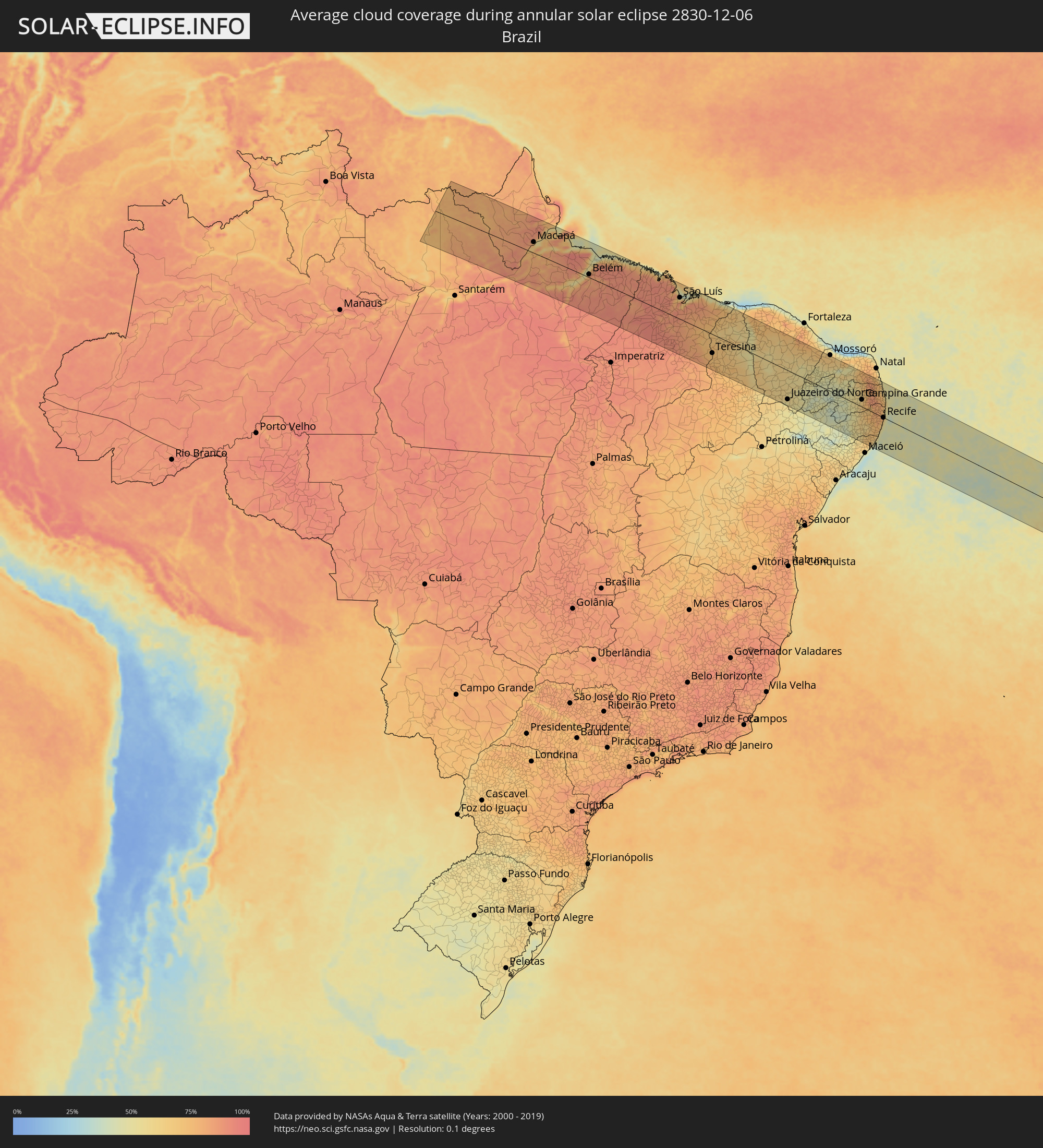 Brazil
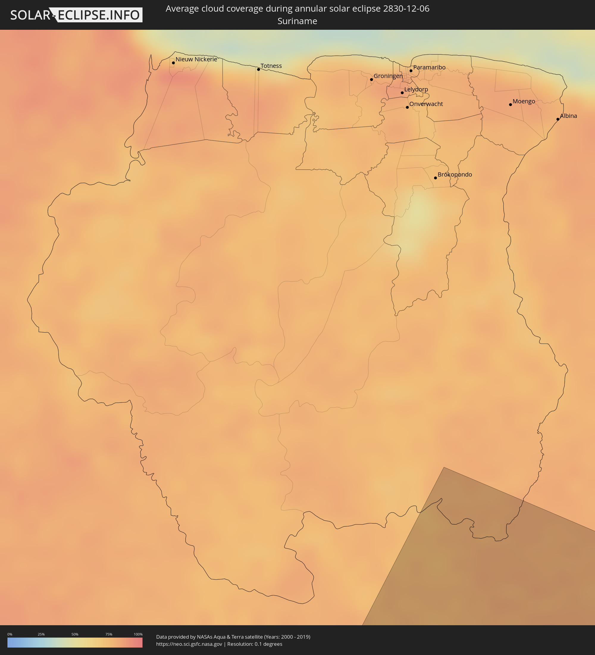 Suriname
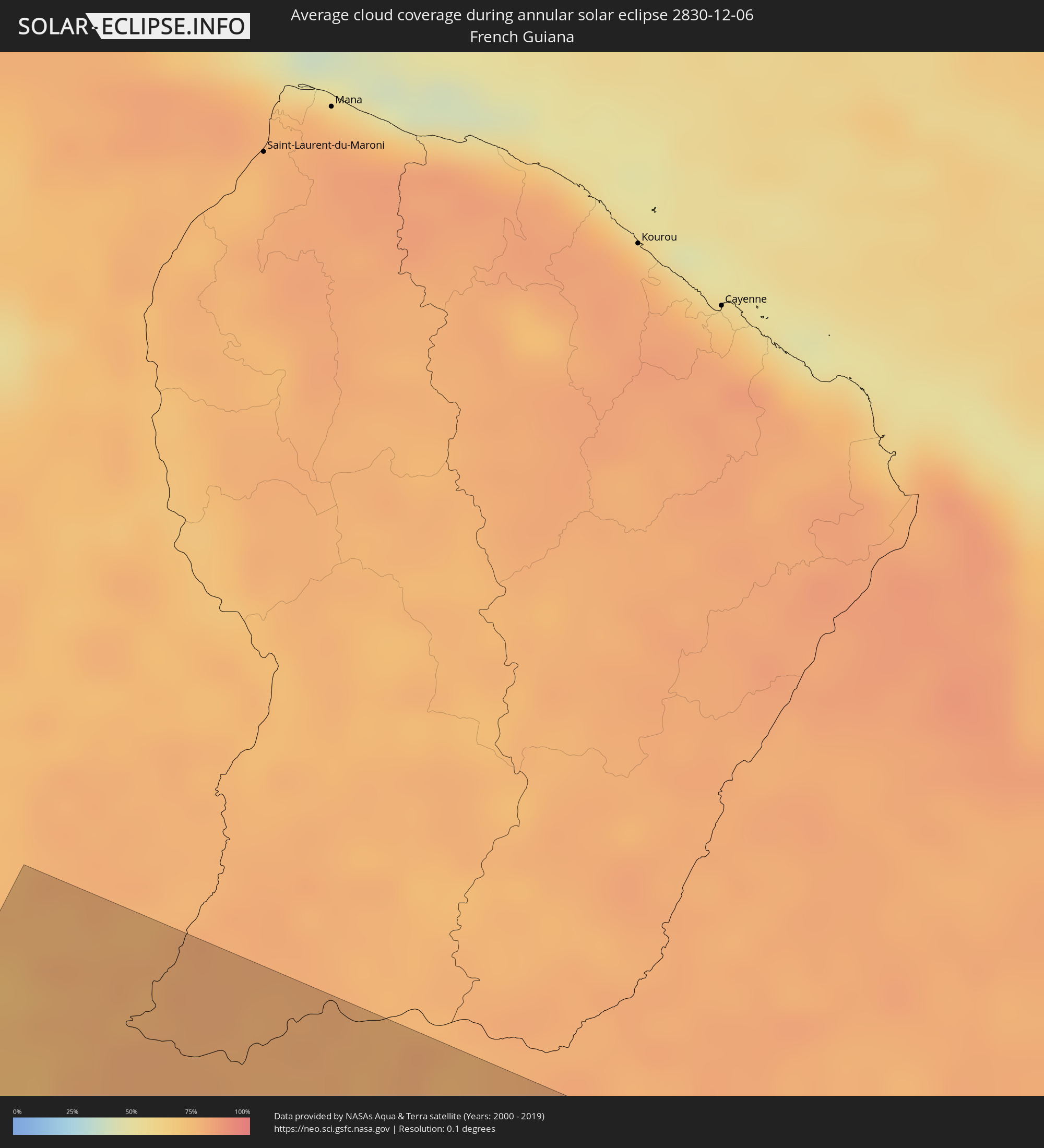 French Guiana
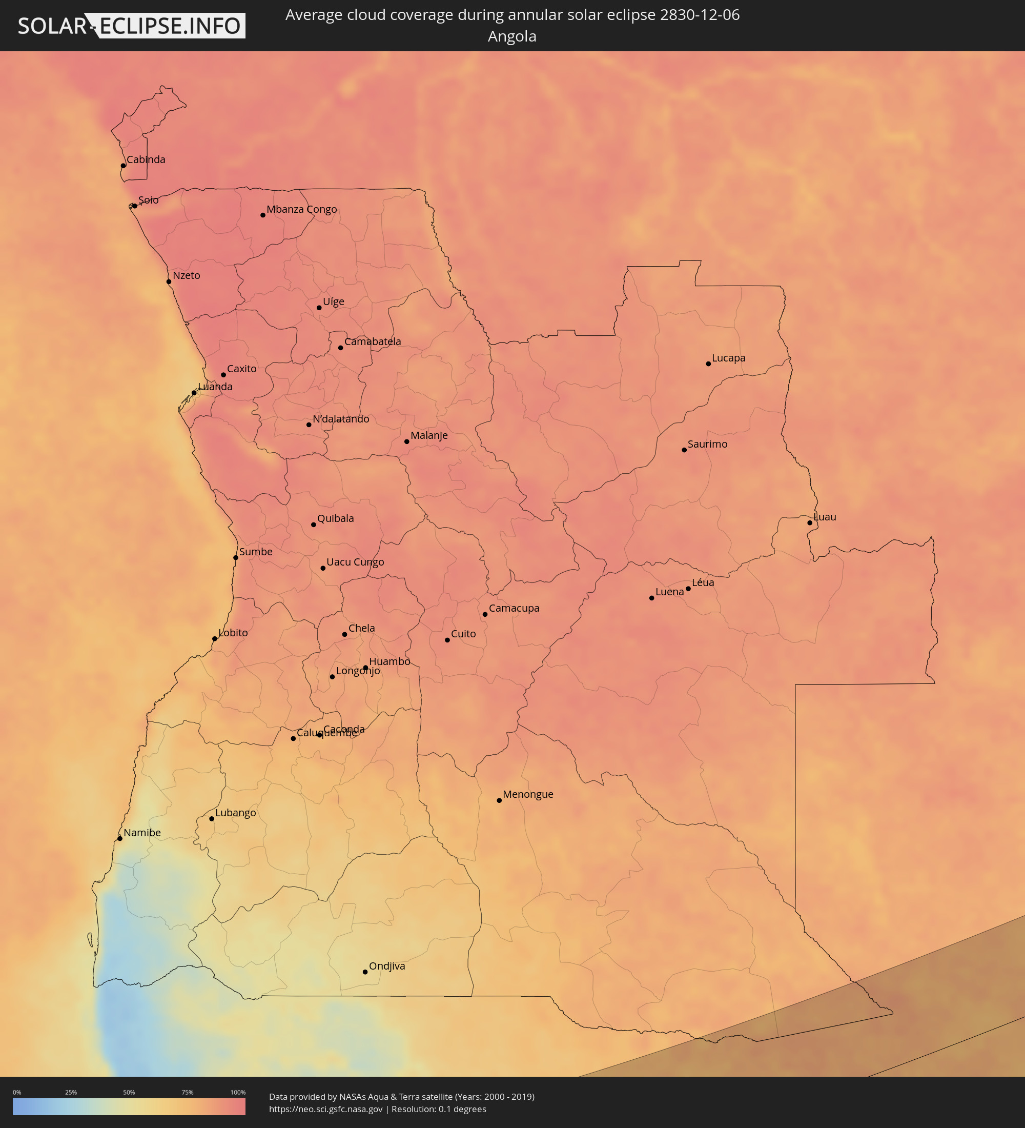 Angola
 Namibia
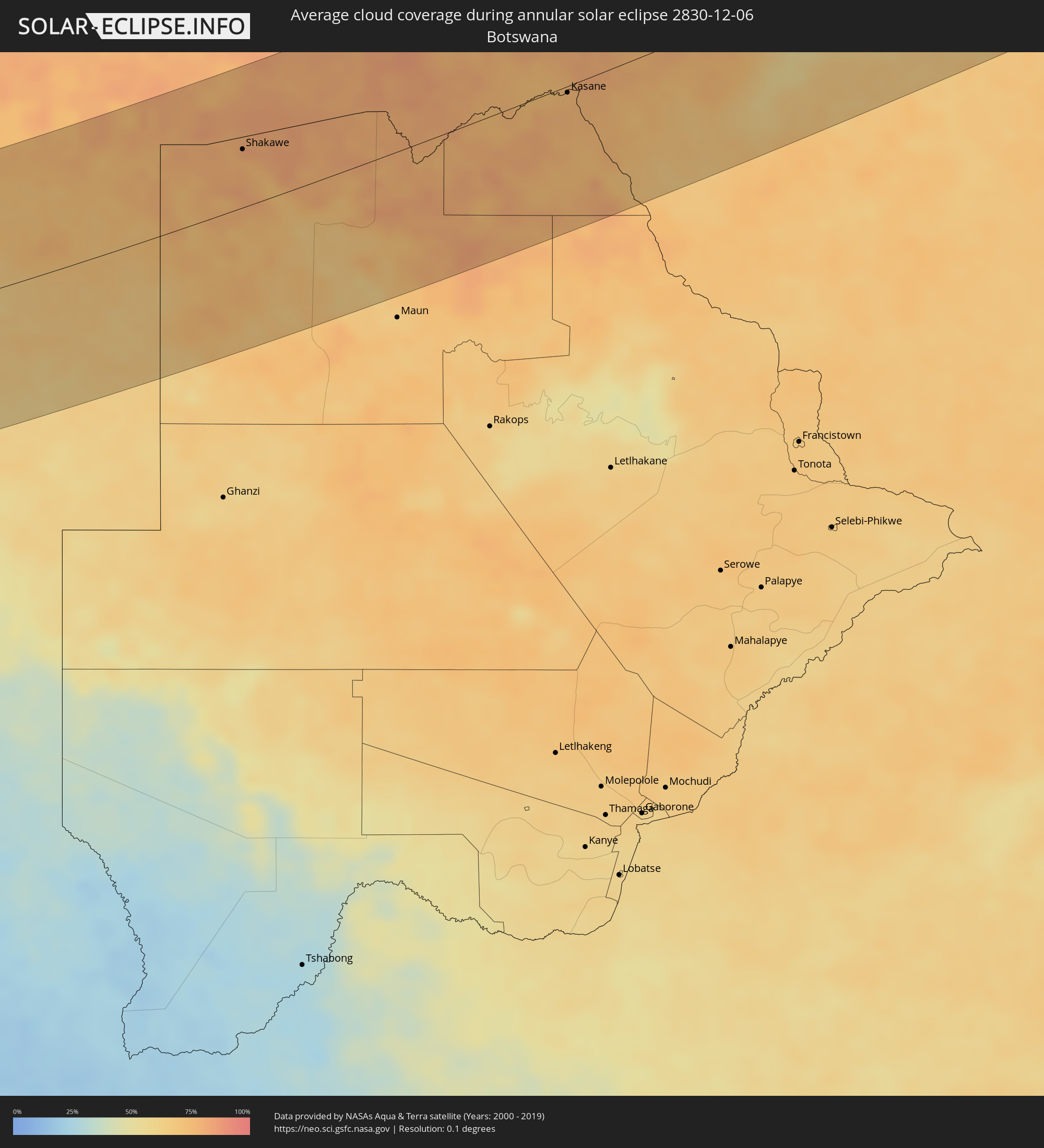 Botswana
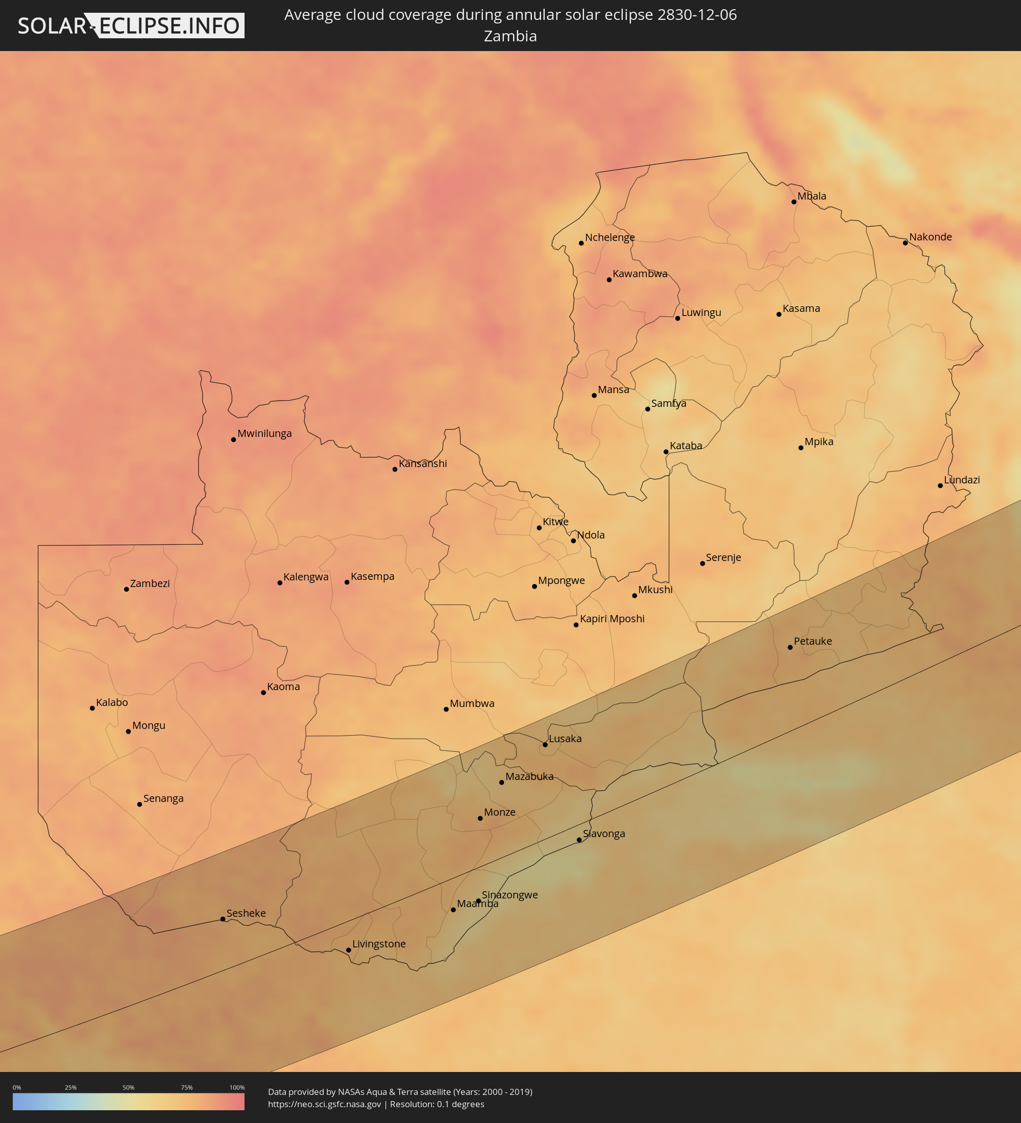 Zambia
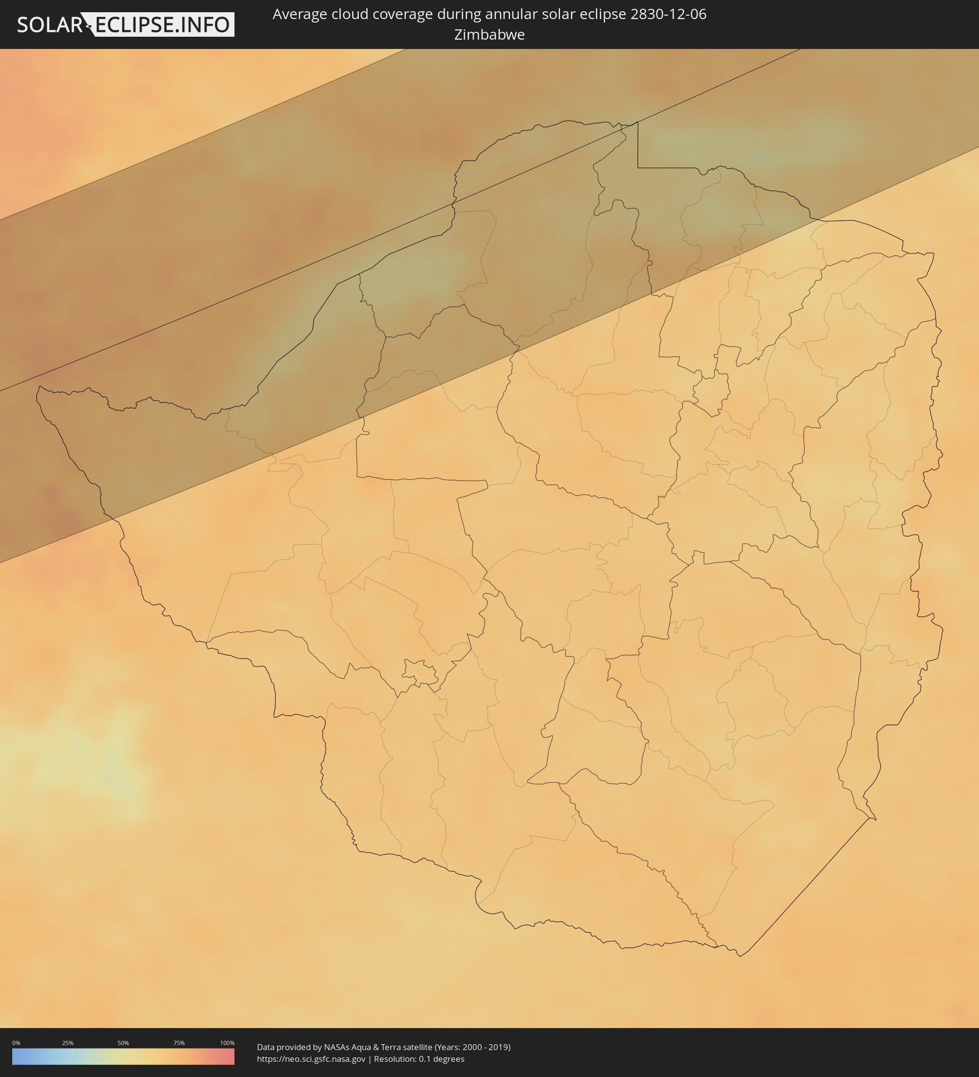 Zimbabwe
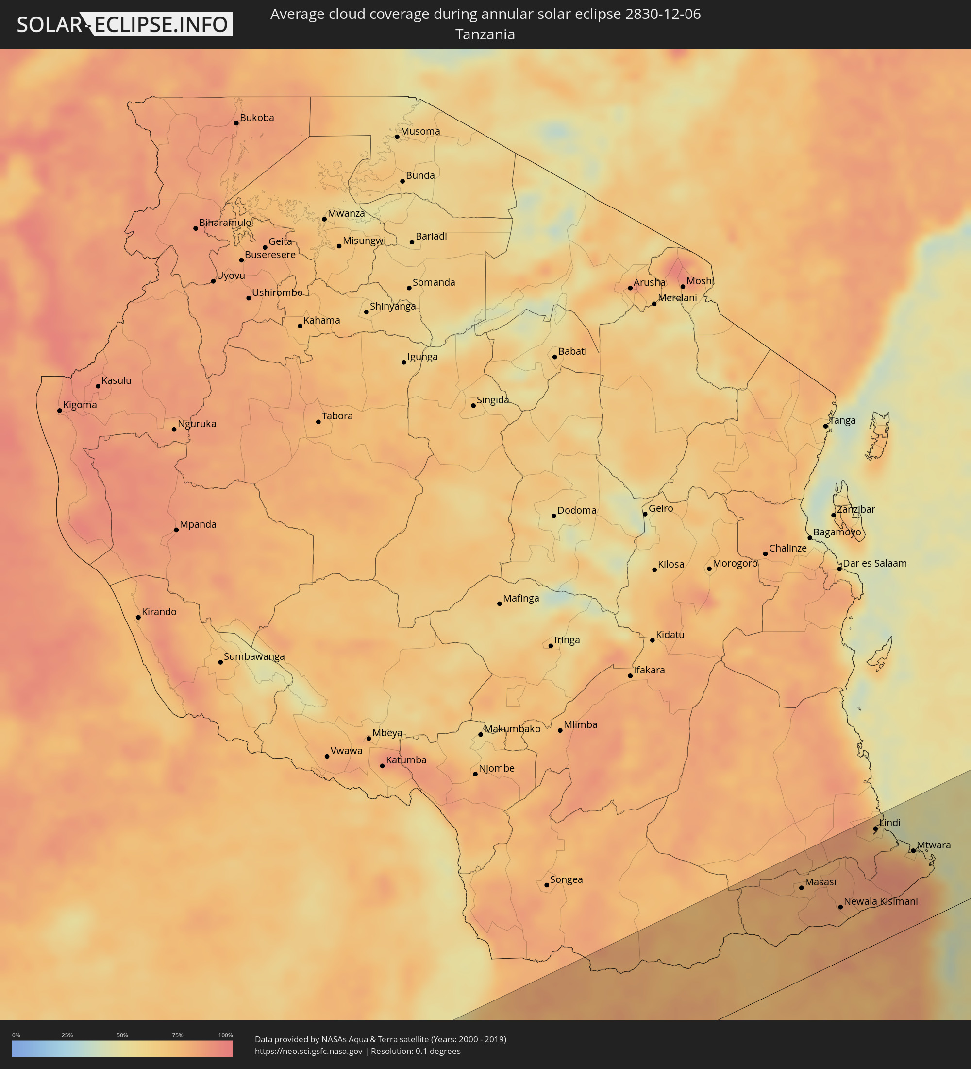 Tanzania
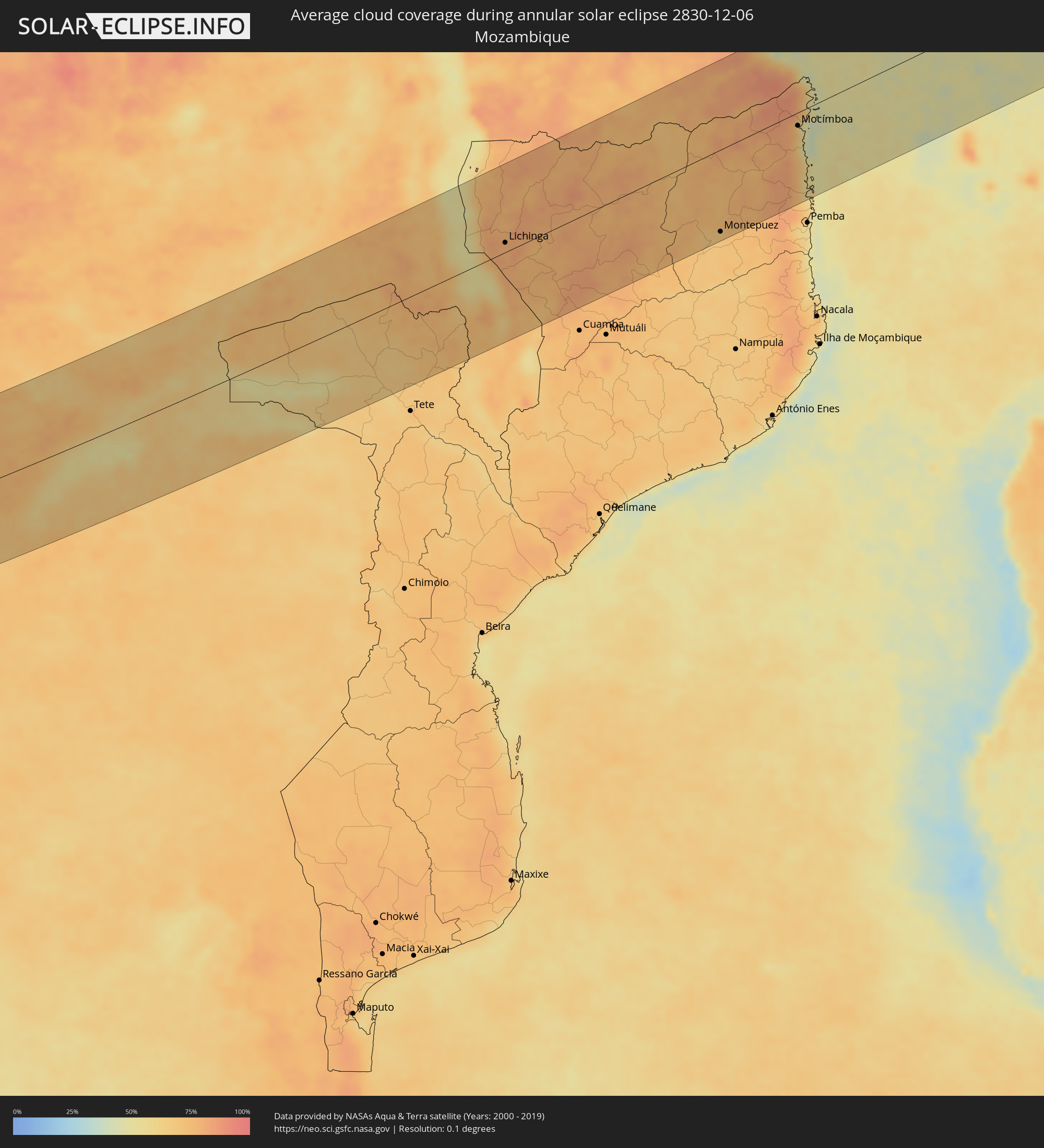 Mozambique
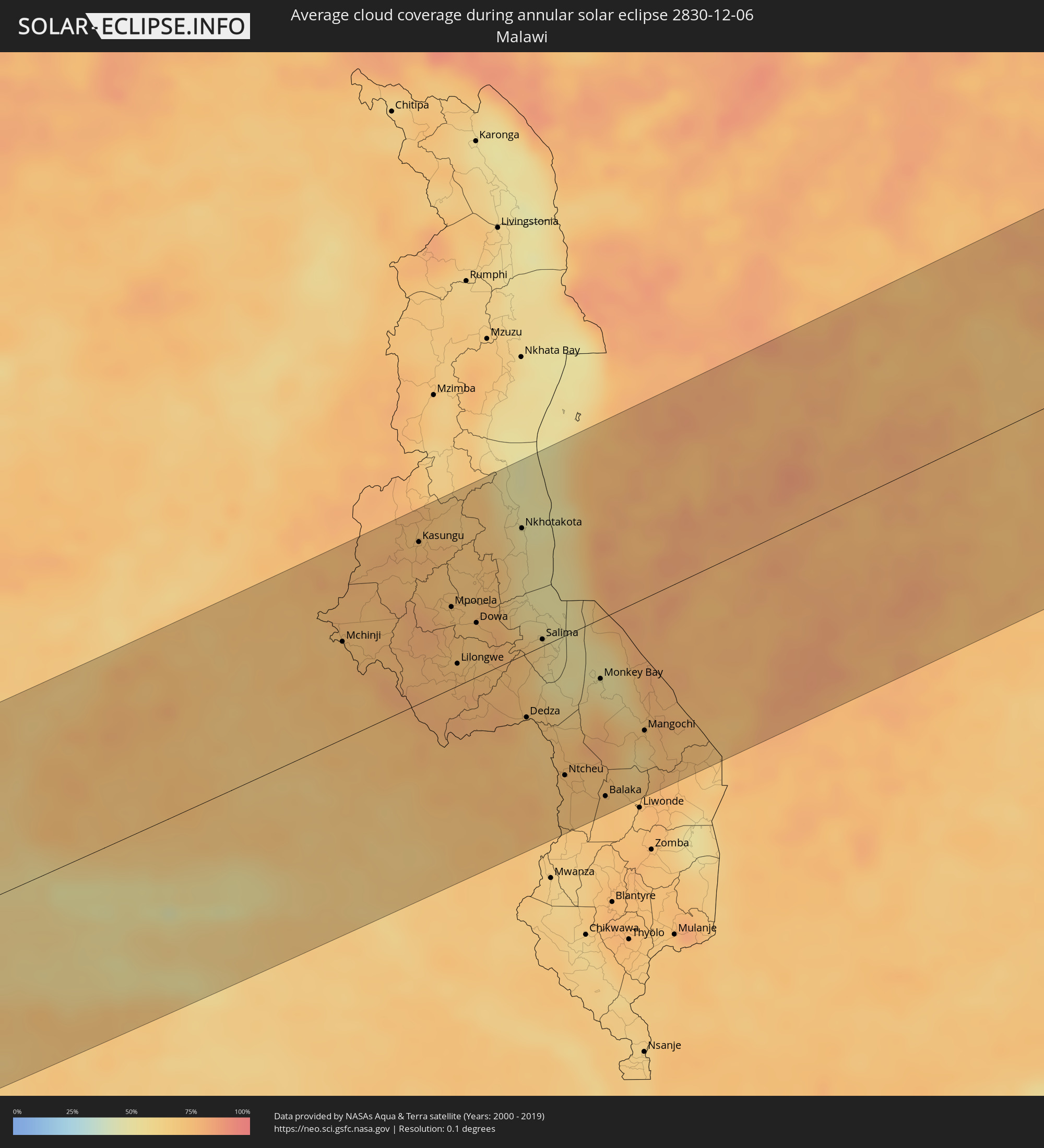 Malawi
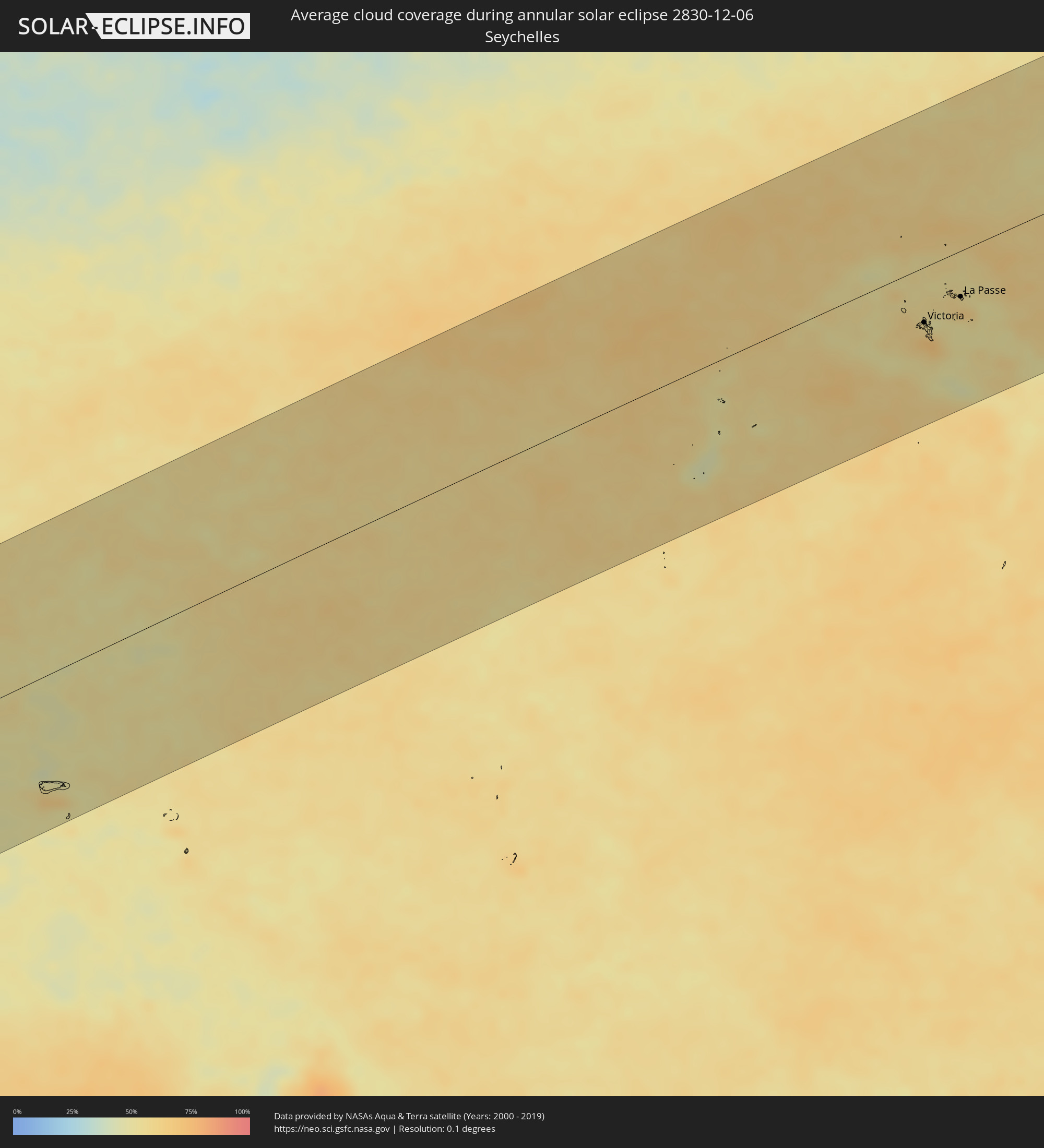 Seychelles
Cities inside the path of the eclipse
The following table shows all locations with a population of more than 5,000 inside the eclipse path. Cities which have more than 100,000 inhabitants are marked bold. A click at the locations opens a detailed map.
| City | Type | Eclipse duration | Local time of max. eclipse | Distance to central line | Ø Cloud coverage |
|
Santana, Amapá
|
annular | - | 09:35:01 UTC+00:00 | 36 km | 63% |
|
Macapá, Amapá
|
annular | - | 06:34:59 UTC-03:00 | 51 km | 68% |
|
Abaetetuba, Pará
|
annular | - | 06:35:55 UTC-03:00 | 30 km | 80% |
|
Belém, Pará
|
annular | - | 06:35:49 UTC-03:00 | 14 km | 77% |
|
Ananindeua, Pará
|
annular | - | 06:35:48 UTC-03:00 | 29 km | 83% |
|
Castanhal, Pará
|
annular | - | 06:35:49 UTC-03:00 | 57 km | 90% |
|
Paragominas, Pará
|
annular | - | 06:36:46 UTC-03:00 | 92 km | 92% |
|
Bacabal, Maranhão
|
annular | - | 06:38:09 UTC-03:00 | 101 km | 90% |
|
São Luís, Maranhão
|
annular | - | 06:37:13 UTC-03:00 | 99 km | 78% |
|
Codó, Maranhão
|
annular | - | 06:38:31 UTC-03:00 | 75 km | 82% |
|
Caxias, Maranhão
|
annular | - | 06:38:58 UTC-03:00 | 91 km | 81% |
|
Teresina, Piauí
|
annular | - | 06:39:19 UTC-03:00 | 88 km | 71% |
|
Juazeiro do Norte, Ceará
|
annular | - | 06:42:30 UTC-03:00 | 133 km | 55% |
|
Iguatu, Ceará
|
annular | - | 06:41:51 UTC-03:00 | 47 km | 59% |
|
Patos, Paraíba
|
annular | - | 06:43:35 UTC-03:00 | 15 km | 36% |
|
Santa Cruz do Capibaribe, Pernambuco
|
annular | - | 06:45:06 UTC-03:00 | 56 km | 53% |
|
Caruaru, Pernambuco
|
annular | - | 06:45:33 UTC-03:00 | 77 km | 61% |
|
Campina Grande, Paraíba
|
annular | - | 06:44:43 UTC-03:00 | 33 km | 65% |
|
Vitória de Santo Antão, Pernambuco
|
annular | - | 06:45:55 UTC-03:00 | 27 km | 76% |
|
Carpina, Pernambuco
|
annular | - | 06:45:43 UTC-03:00 | 2 km | 78% |
|
São Lourenço da Mata, Pernambuco
|
annular | - | 06:46:02 UTC-03:00 | 2 km | 79% |
|
Jaboatão, Pernambuco
|
annular | - | 06:46:12 UTC-03:00 | 19 km | 66% |
|
Igarassu, Pernambuco
|
annular | - | 06:45:58 UTC-03:00 | 20 km | 65% |
|
Recife, Pernambuco
|
annular | - | 06:46:11 UTC-03:00 | 0 km | 58% |
|
João Pessoa, Paraíba
|
annular | - | 06:45:23 UTC-03:00 | 94 km | 69% |
|
Khorixas, Kunene
|
annular | - | 14:12:34 UTC+02:00 | 48 km | 31% |
|
Omaruru, Erongo
|
annular | - | 14:14:46 UTC+02:00 | 90 km | 37% |
|
Outjo, Kunene
|
annular | - | 14:16:35 UTC+02:00 | 47 km | 46% |
|
Otjiwarongo, Otjozondjupa
|
annular | - | 14:17:50 UTC+02:00 | 4 km | 48% |
|
Okakarara, Otjozondjupa
|
annular | - | 14:20:08 UTC+02:00 | 38 km | 52% |
|
Tsumeb, Oshikoto
|
annular | - | 14:22:16 UTC+02:00 | 99 km | 61% |
|
Grootfontein, Otjozondjupa
|
annular | - | 14:23:10 UTC+02:00 | 52 km | 59% |
|
Shakawe, North-West
|
annular | - | 14:34:55 UTC+02:00 | 59 km | 79% |
|
Katima Mulilo, Zambezi
|
annular | - | 14:42:00 UTC+02:00 | 61 km | 77% |
|
Sesheke, Western
|
annular | - | 14:42:06 UTC+02:00 | 62 km | 77% |
|
Kasane, North-West
|
annular | - | 14:43:43 UTC+02:00 | 6 km | 76% |
|
Livingstone, Southern
|
annular | - | 14:45:18 UTC+02:00 | 37 km | 74% |
|
Maamba, Southern
|
annular | - | 14:48:40 UTC+02:00 | 40 km | 60% |
|
Sinazongwe, Southern
|
annular | - | 14:49:27 UTC+02:00 | 42 km | 57% |
|
Monze, Southern
|
annular | - | 14:50:37 UTC+02:00 | 58 km | 76% |
|
Mazabuka, Southern
|
annular | - | 14:51:40 UTC+02:00 | 90 km | 68% |
|
Nakambala, Southern
|
annular | - | 14:51:45 UTC+02:00 | 91 km | 66% |
|
Lusaka, Lusaka
|
annular | - | 14:53:16 UTC+02:00 | 114 km | 70% |
|
Siavonga, Southern
|
annular | - | 14:52:49 UTC+02:00 | 20 km | 57% |
|
Petauke, Eastern
|
annular | - | 15:00:16 UTC+02:00 | 101 km | 74% |
|
Mchinji, Central Region
|
annular | - | 15:03:21 UTC+02:00 | 75 km | 74% |
|
Kasungu, Central Region
|
annular | - | 15:05:08 UTC+02:00 | 125 km | 76% |
|
Mponela, Central Region
|
annular | - | 15:04:59 UTC+02:00 | 63 km | 75% |
|
Lilongwe, Central Region
|
annular | - | 15:04:36 UTC+02:00 | 17 km | 75% |
|
Ntchisi, Central Region
|
annular | - | 15:05:16 UTC+02:00 | 56 km | 72% |
|
Dowa, Central Region
|
annular | - | 15:05:10 UTC+02:00 | 42 km | 71% |
|
Nkhotakota, Central Region
|
annular | - | 15:06:28 UTC+02:00 | 99 km | 54% |
|
Dedza, Central Region
|
annular | - | 15:04:58 UTC+02:00 | 49 km | 72% |
|
Salima, Central Region
|
annular | - | 15:05:48 UTC+02:00 | 5 km | 58% |
|
Ntcheu, Central Region
|
annular | - | 15:04:56 UTC+02:00 | 108 km | 71% |
|
Monkey Bay, Southern Region
|
annular | - | 15:06:09 UTC+02:00 | 46 km | 59% |
|
Balaka, Southern Region
|
annular | - | 15:05:13 UTC+02:00 | 138 km | 73% |
|
Lichinga, Niassa
|
annular | - | 15:07:26 UTC+02:00 | 16 km | 77% |
|
Mangochi, Southern Region
|
annular | - | 15:06:13 UTC+02:00 | 102 km | 66% |
|
Masuguru, Mtwara
|
annular | - | 16:13:29 UTC+03:00 | 64 km | 72% |
|
Nangomba, Mtwara
|
annular | - | 16:14:02 UTC+03:00 | 107 km | 76% |
|
Nachingwea, Lindi
|
annular | - | 16:14:50 UTC+03:00 | 147 km | 77% |
|
Masasi, Mtwara
|
annular | - | 16:14:33 UTC+03:00 | 111 km | 77% |
|
Lukuledi, Mtwara
|
annular | - | 16:14:41 UTC+03:00 | 126 km | 77% |
|
Chiungutwa, Mtwara
|
annular | - | 16:14:36 UTC+03:00 | 85 km | 82% |
|
Montepuez, Cabo Delgado
|
annular | - | 15:12:24 UTC+02:00 | 140 km | 68% |
|
Namalenga, Mtwara
|
annular | - | 16:14:40 UTC+03:00 | 73 km | 82% |
|
Lulindi, Mtwara
|
annular | - | 16:14:50 UTC+03:00 | 85 km | 82% |
|
Nanganga, Mtwara
|
annular | - | 16:15:15 UTC+03:00 | 128 km | 81% |
|
Newala Kisimani, Mtwara
|
annular | - | 16:14:52 UTC+03:00 | 65 km | 76% |
|
Nyangao, Lindi
|
annular | - | 16:15:27 UTC+03:00 | 126 km | 80% |
|
Luchingu, Mtwara
|
annular | - | 16:14:58 UTC+03:00 | 67 km | 81% |
|
Kitangari, Mtwara
|
annular | - | 16:15:12 UTC+03:00 | 92 km | 84% |
|
Mtama, Lindi
|
annular | - | 16:15:34 UTC+03:00 | 126 km | 82% |
|
Mahuta, Mtwara
|
annular | - | 16:15:08 UTC+03:00 | 65 km | 78% |
|
Nanhyanga, Mtwara
|
annular | - | 16:15:18 UTC+03:00 | 67 km | 82% |
|
Namikupa, Mtwara
|
annular | - | 16:15:19 UTC+03:00 | 61 km | 82% |
|
Mingoyo, Lindi
|
annular | - | 16:16:01 UTC+03:00 | 134 km | 77% |
|
Tandahimba, Mtwara
|
annular | - | 16:15:26 UTC+03:00 | 68 km | 82% |
|
Lindi, Lindi
|
annular | - | 16:16:13 UTC+03:00 | 140 km | 66% |
|
Kitama, Mtwara
|
annular | - | 16:15:34 UTC+03:00 | 67 km | 85% |
|
Nanyamba, Mtwara
|
annular | - | 16:15:43 UTC+03:00 | 65 km | 87% |
|
Mtwara, Mtwara
|
annular | - | 16:16:28 UTC+03:00 | 91 km | 77% |
|
Madimba, Mtwara
|
annular | - | 16:16:30 UTC+03:00 | 70 km | 73% |
|
Mocímboa, Cabo Delgado
|
annular | - | 15:15:39 UTC+02:00 | 23 km | 57% |
|
Port Glaud, Port Glaud
|
annular | - | 17:29:32 UTC+04:00 | 62 km | 61% |
|
Bel Ombre, Bel Ombre
|
annular | - | 17:29:34 UTC+04:00 | 57 km | 68% |
|
Beau Vallon, Beau Vallon
|
annular | - | 17:29:34 UTC+04:00 | 58 km | 68% |
|
Victoria, English River
|
annular | - | 17:29:34 UTC+04:00 | 58 km | 68% |
|
Anse Boileau, Anse Boileau
|
annular | - | 17:29:31 UTC+04:00 | 70 km | 66% |
|
Takamaka, Takamaka
|
annular | - | 17:29:30 UTC+04:00 | 76 km | 56% |
|
Cascade, Cascade
|
annular | - | 17:29:33 UTC+04:00 | 66 km | 66% |
|
Anse Royale, Anse Royale
|
annular | - | 17:29:31 UTC+04:00 | 73 km | 66% |
|
La Passe, Inner Islands
|
annular | - | 17:29:48 UTC+04:00 | 48 km | 64% |