Totale Sonnenfinsternis vom 26.04.2609
| Wochentag: | Mittwoch |
| Maximale Dauer der Verfinsterung: | 05m23s |
| Maximale Breite des Finsternispfades: | 233 km |
| Saroszyklus: | 148 |
| Bedeckungsgrad: | 100% |
| Magnitude: | 1.0665 |
| Gamma: | 0.3627 |
Wo kann man die Sonnenfinsternis vom 26.04.2609 sehen?
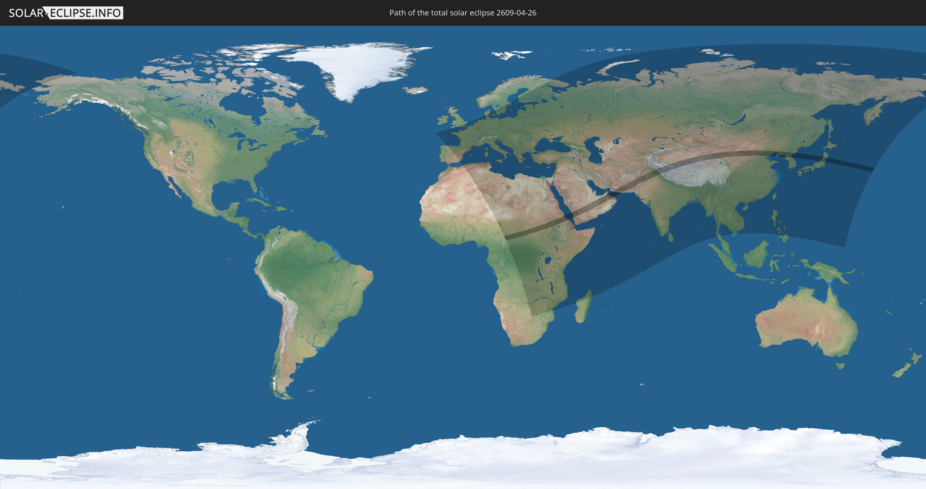
Die Sonnenfinsternis am 26.04.2609 kann man in 127 Ländern als partielle Sonnenfinsternis beobachten.
Der Finsternispfad verläuft durch 17 Länder. Nur in diesen Ländern ist sie als totale Sonnenfinsternis zu sehen.
In den folgenden Ländern ist die Sonnenfinsternis total zu sehen
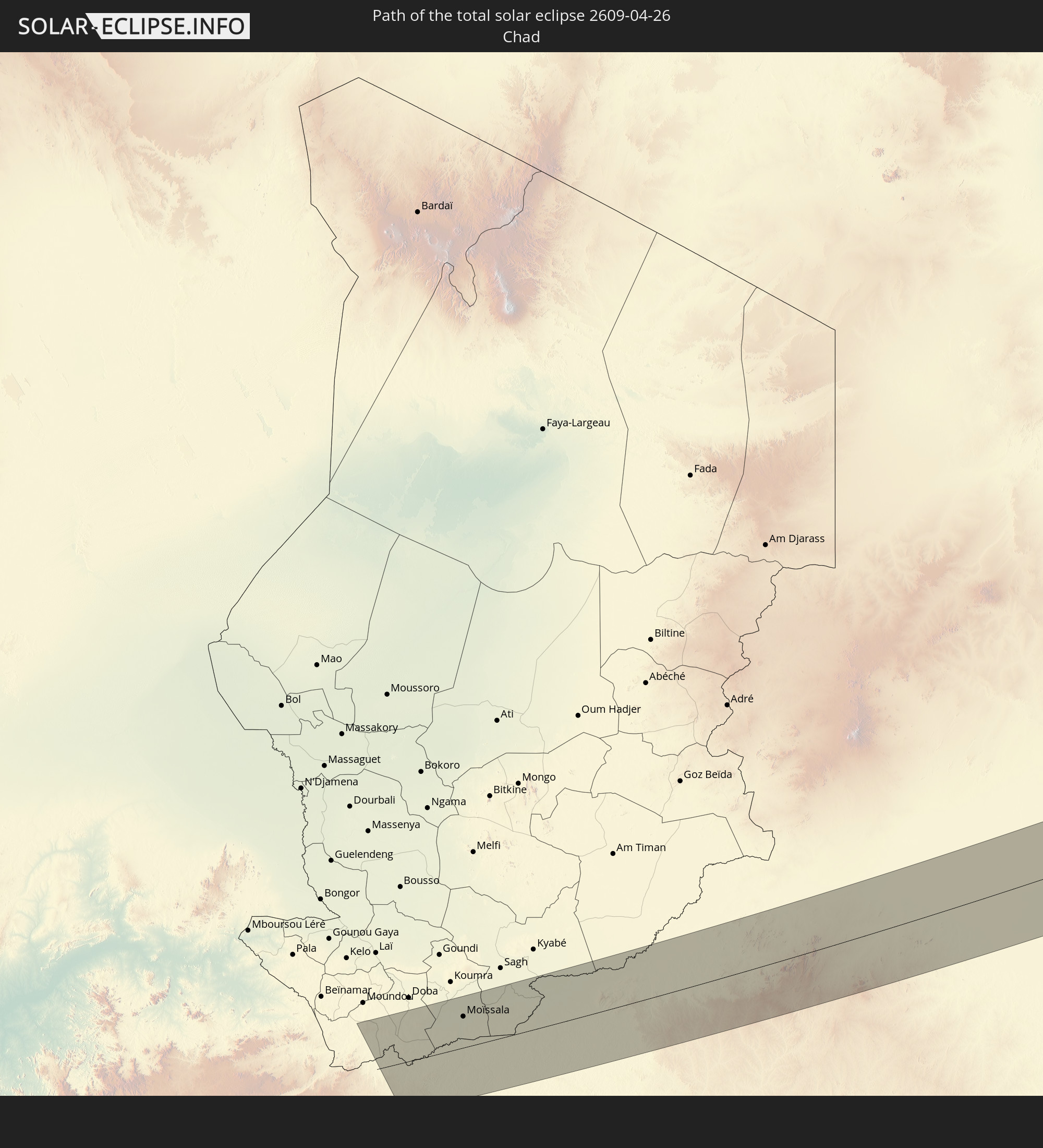 Tschad
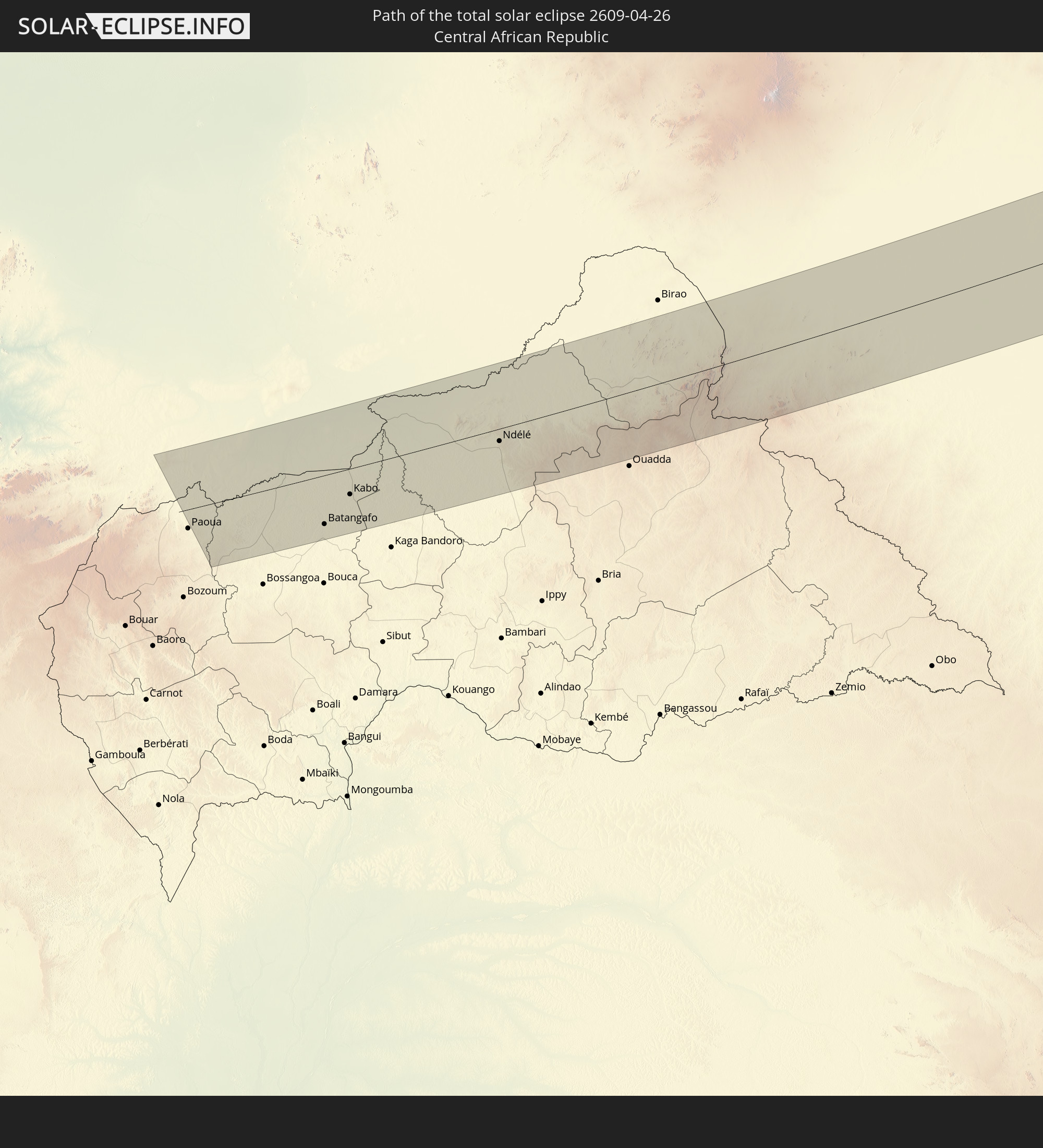 Zentralafrikanische Republik
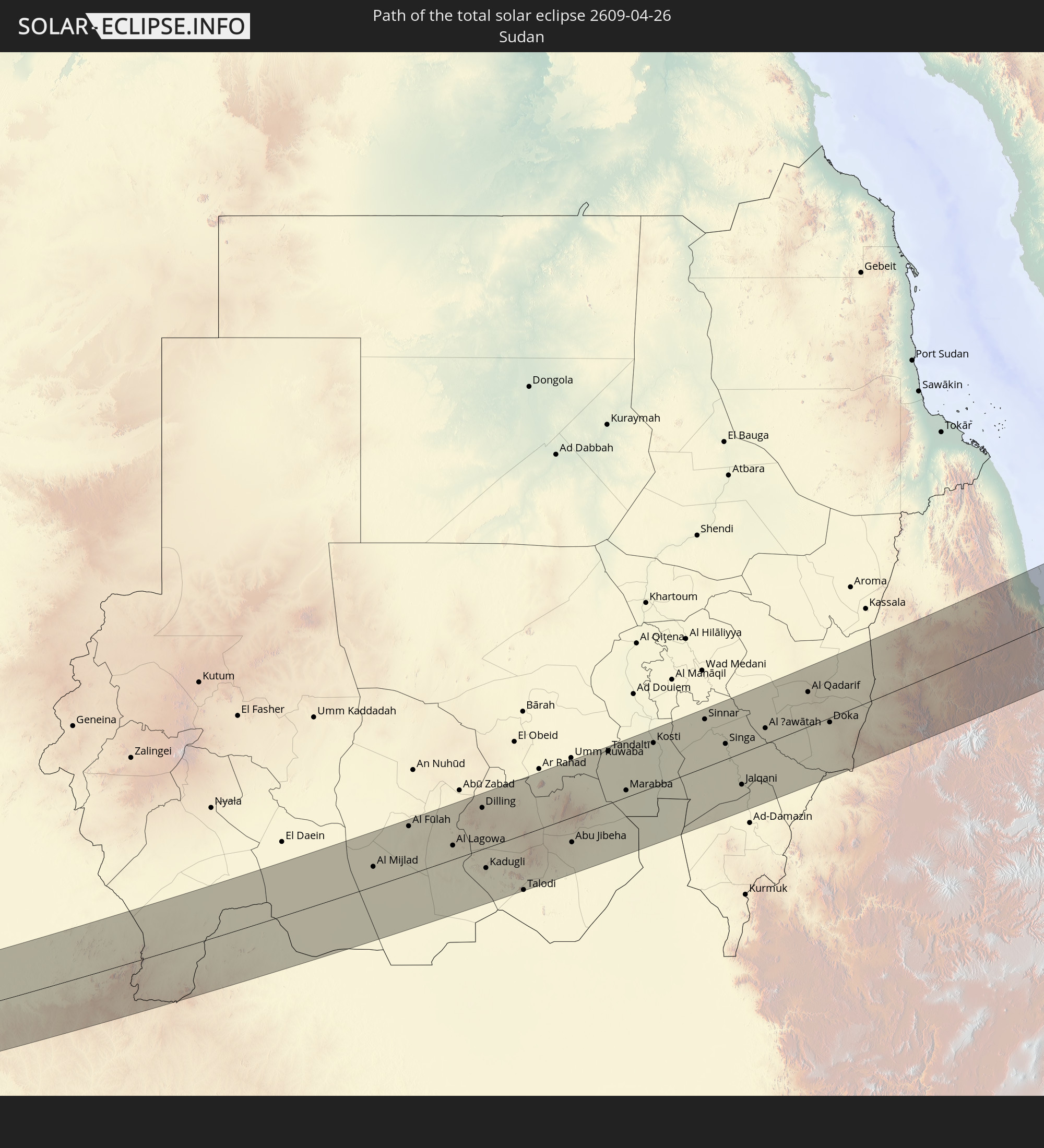 Sudan
Sudan
 Südsudan
 Äthiopien
 Saudi-Arabien
 Eritrea
 Jemen
Jemen
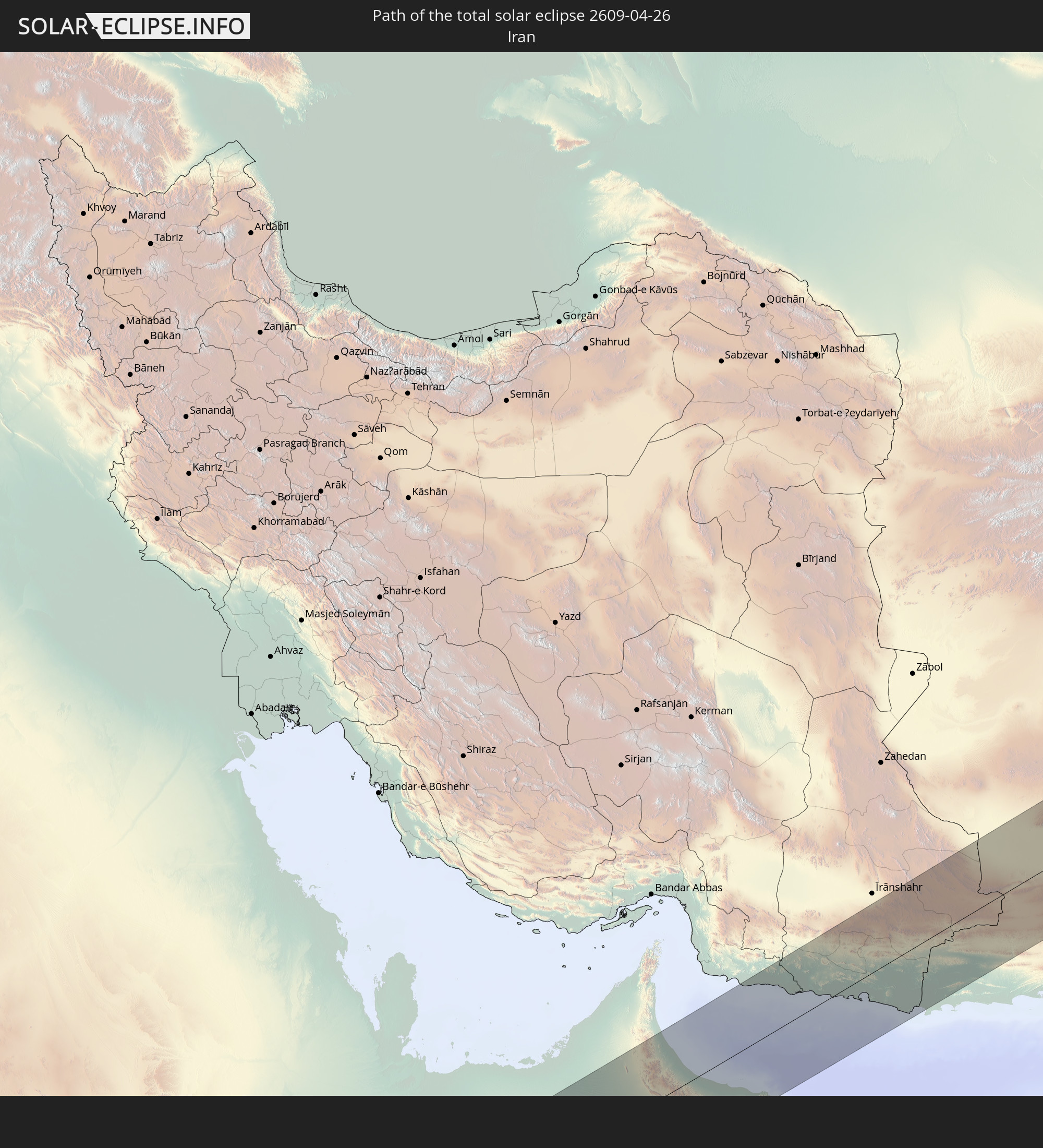 Iran
Iran
 Vereinigte Arabische Emirate
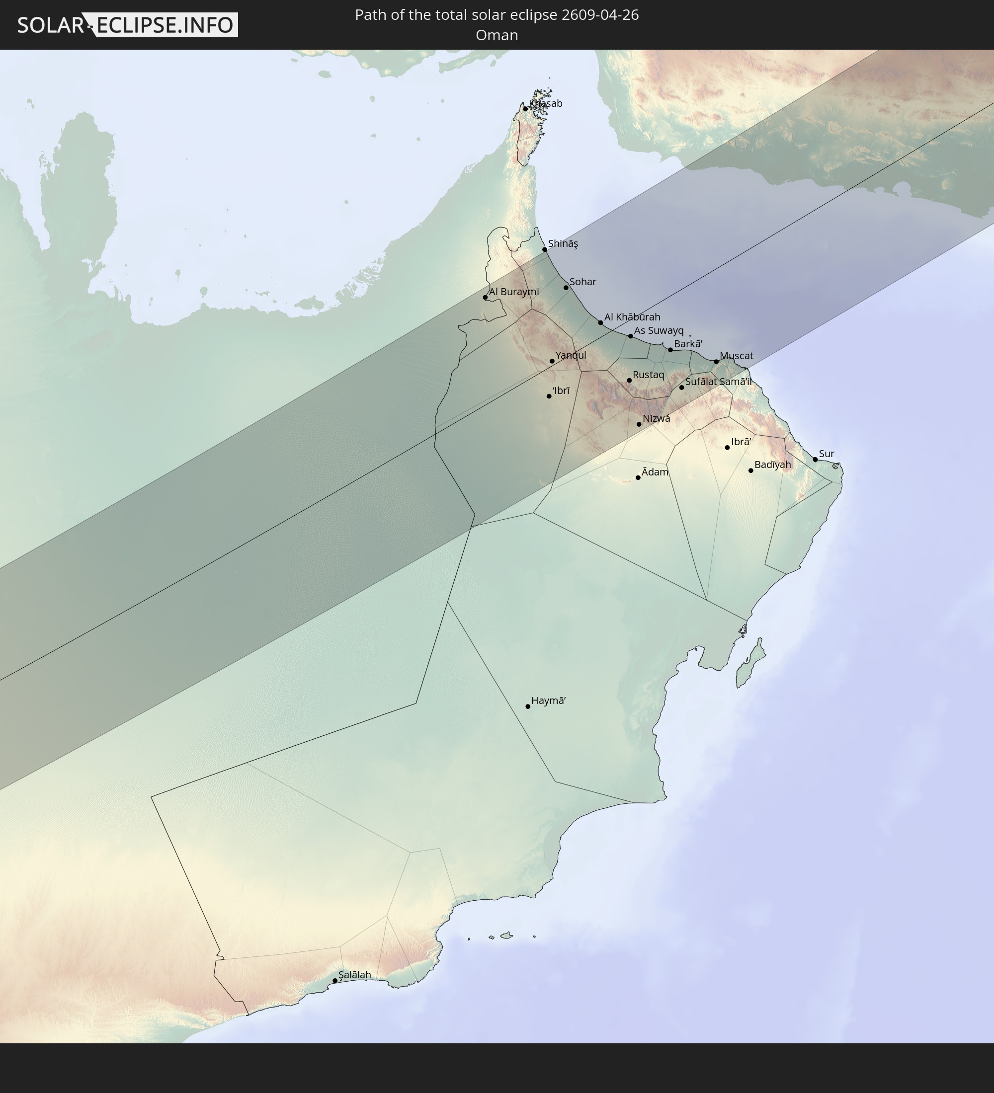 Oman
Oman
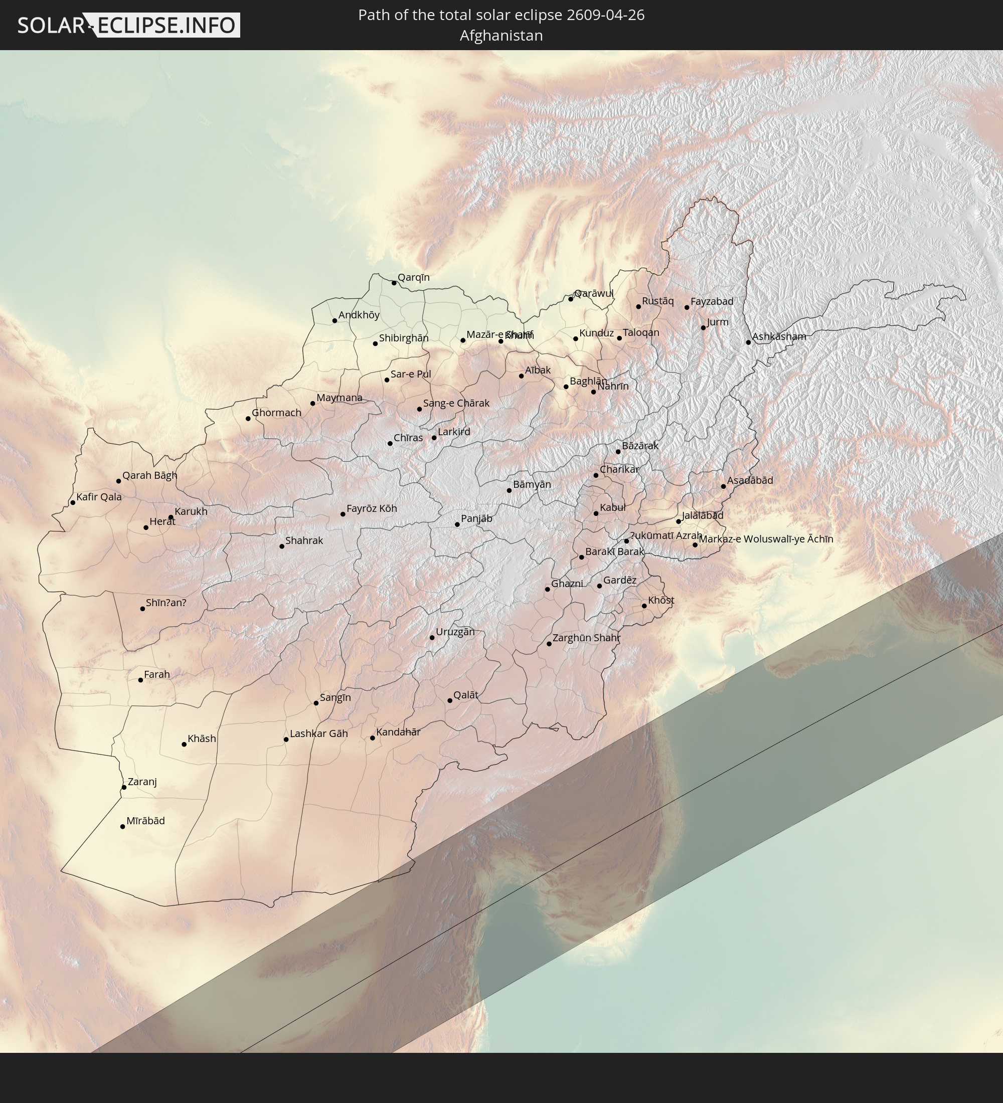 Afghanistan
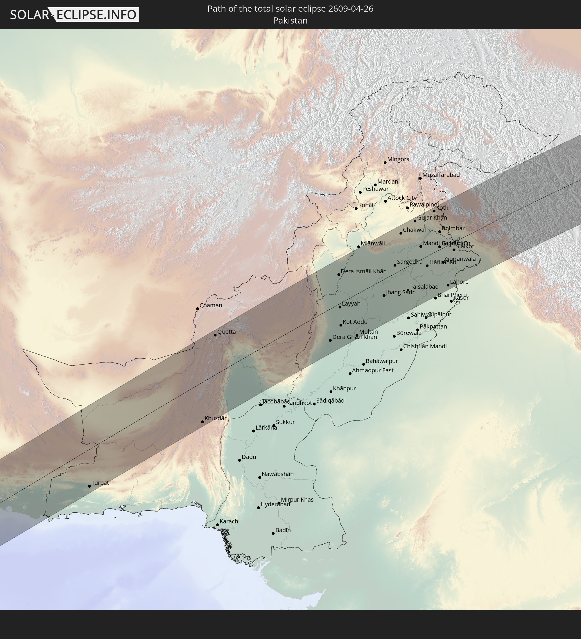 Pakistan
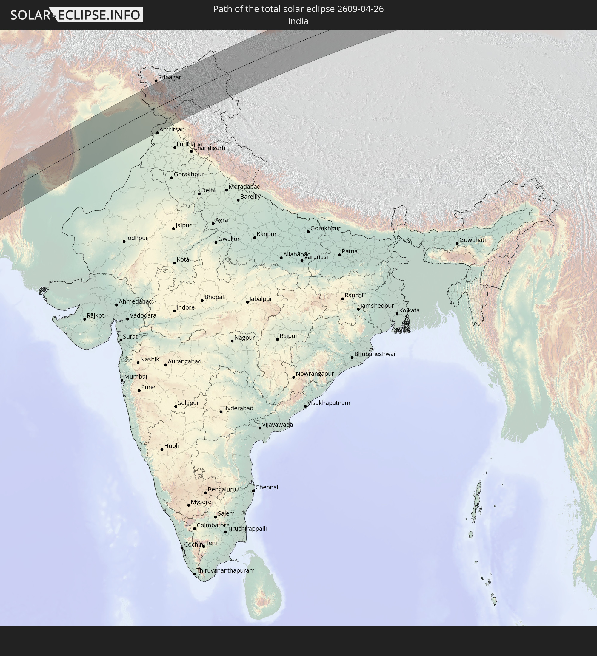 Indien
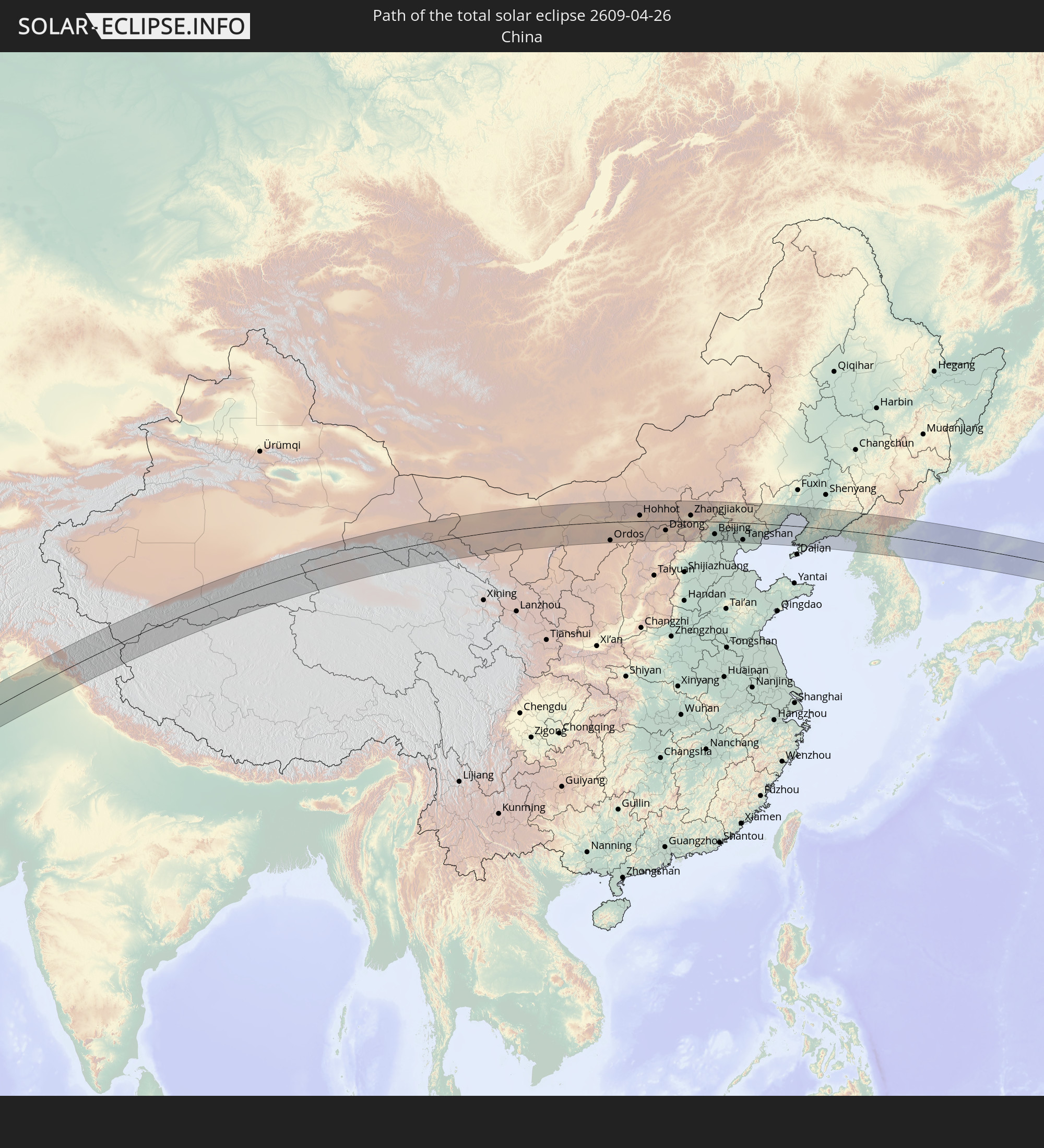 Volksrepublik China
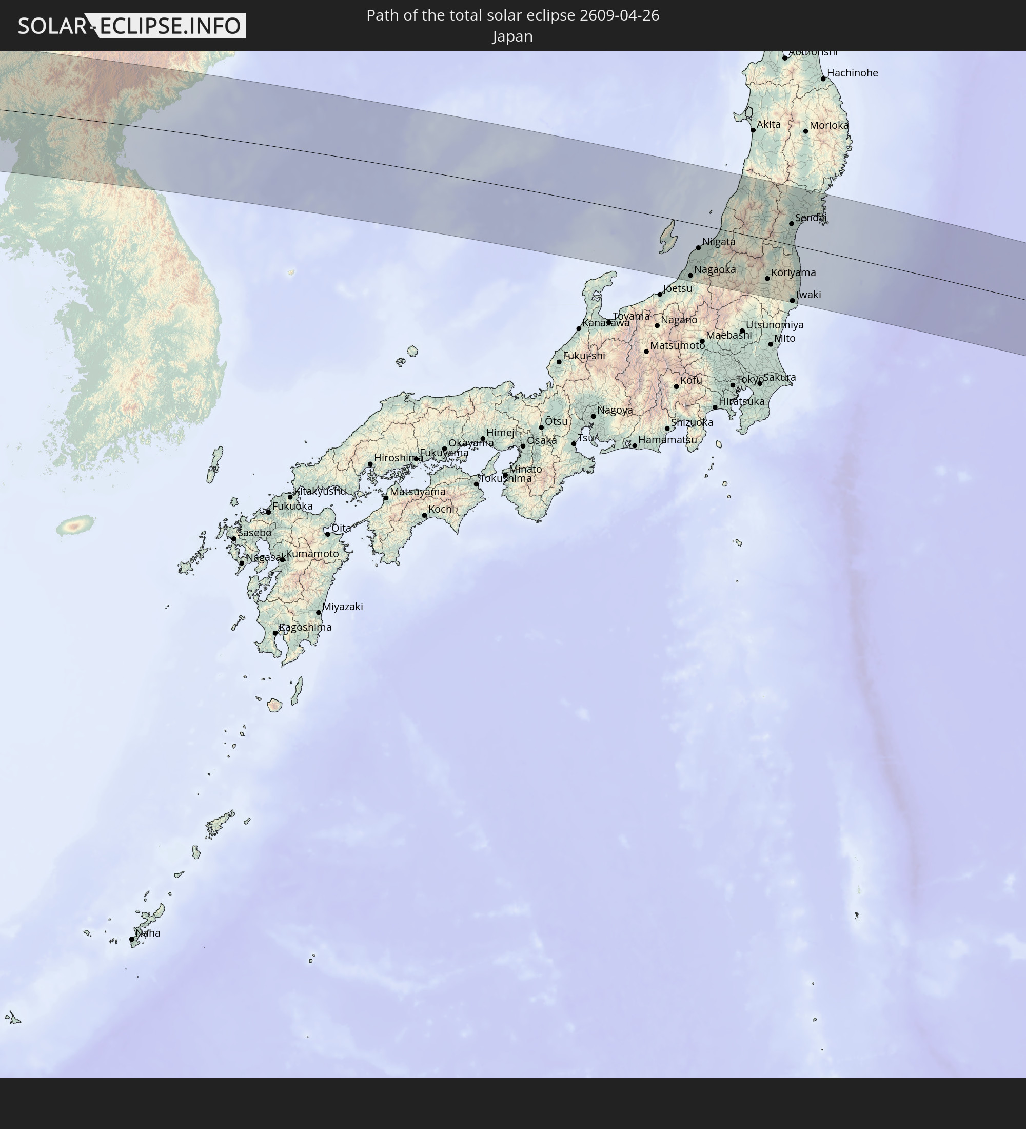 Japan
Japan
 Nordkorea
In den folgenden Ländern ist die Sonnenfinsternis partiell zu sehen
 Russland
 Vereinigte Staaten
 Spanien
 Algerien
 Vereinigtes Königreich
 Frankreich
 Guernsey
 Jersey
 Niger
Niger
 Andorra
 Belgien
 Nigeria
 Niederlande
 Luxemburg
 Deutschland
 Schweiz
 Italien
 Monaco
 Tunesien
 Dänemark
 Kamerun
 Libyen
 Liechtenstein
 Österreich
 Schweden
 Republik Kongo
 Angola
 Tschechien
 Demokratische Republik Kongo
 San Marino
 Vatikanstadt
 Slowenien
 Tschad
 Kroatien
 Polen
Polen
 Malta
Malta
 Zentralafrikanische Republik
 Bosnien und Herzegowina
 Ungarn
 Slowakei
 Montenegro
 Serbien
 Albanien
 Åland Islands
 Griechenland
 Botswana
 Rumänien
 Mazedonien
 Finnland
 Litauen
 Lettland
 Estland
 Sudan
Sudan
 Sambia
 Ukraine
 Bulgarien
 Weißrussland
 Ägypten
 Simbabwe
 Türkei
 Moldawien
 Ruanda
 Burundi
 Tansania
 Uganda
 Mosambik
 Republik Zypern
 Malawi
 Äthiopien
 Kenia
Kenia
 Staat Palästina
 Israel
 Saudi-Arabien
 Jordanien
 Libanon
 Syrien
 Eritrea
 Irak
Irak
 Georgien
 Französische Süd- und Antarktisgebiete
 Somalia
 Dschibuti
 Jemen
Jemen
 Madagaskar
 Komoren
 Armenien
 Iran
Iran
 Aserbaidschan
 Mayotte
 Seychellen
 Kasachstan
 Kuwait
 Bahrain
 Katar
Katar
 Vereinigte Arabische Emirate
 Oman
Oman
 Turkmenistan
 Usbekistan
 Mauritius
 Afghanistan
 Pakistan
 Tadschikistan
 Indien
 Kirgisistan
 Malediven
 Volksrepublik China
 Sri Lanka
 Nepal
Nepal
 Mongolei
 Bangladesch
 Bhutan
 Myanmar
 Thailand
 Laos
Laos
 Vietnam
 Kambodscha
 Macau
Macau
 Hongkong
 Taiwan
 Philippinen
 Japan
Japan
 Nordkorea
 Südkorea
 Palau
Palau
 Föderierte Staaten von Mikronesien
 Guam
Guam
 Nördliche Marianen
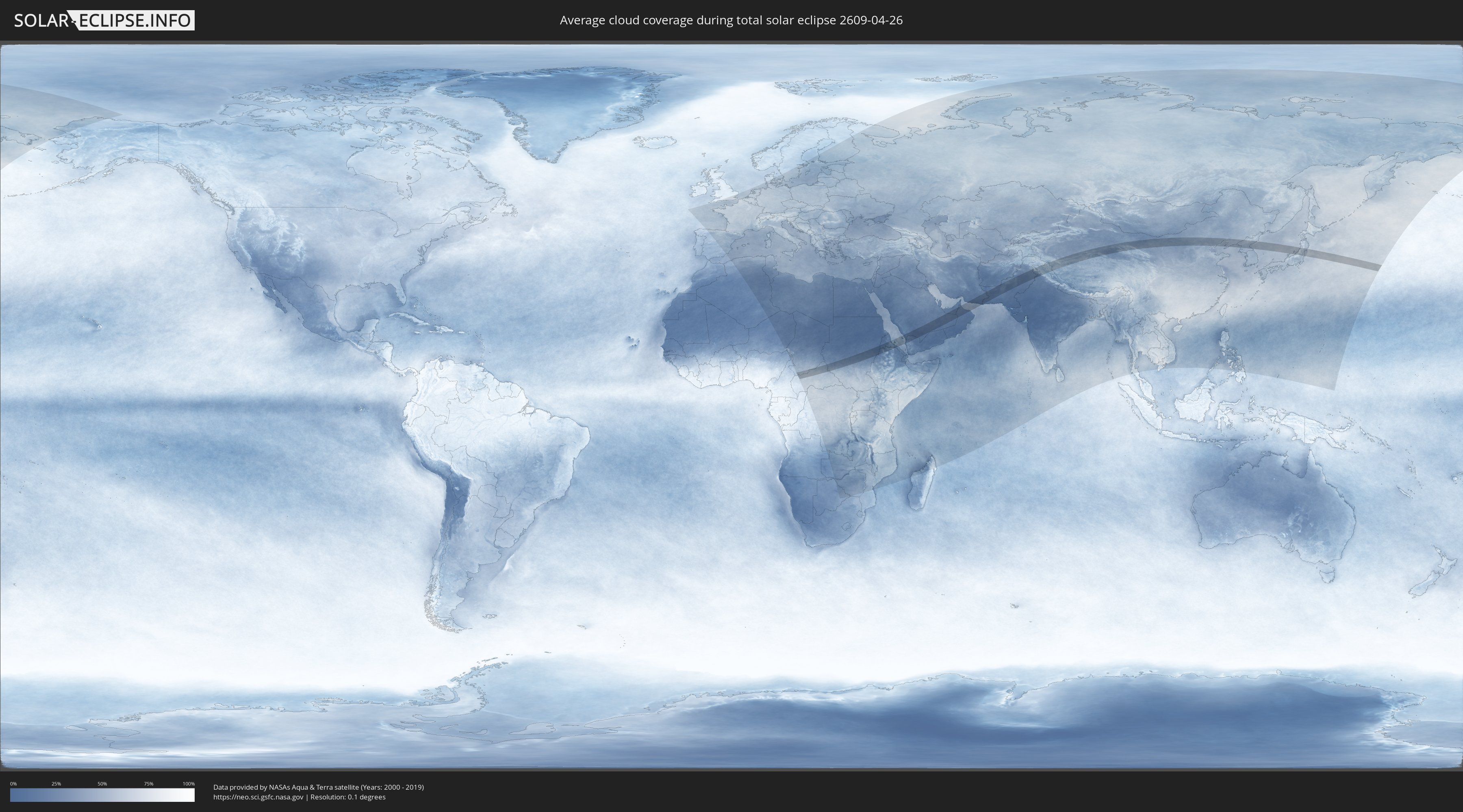
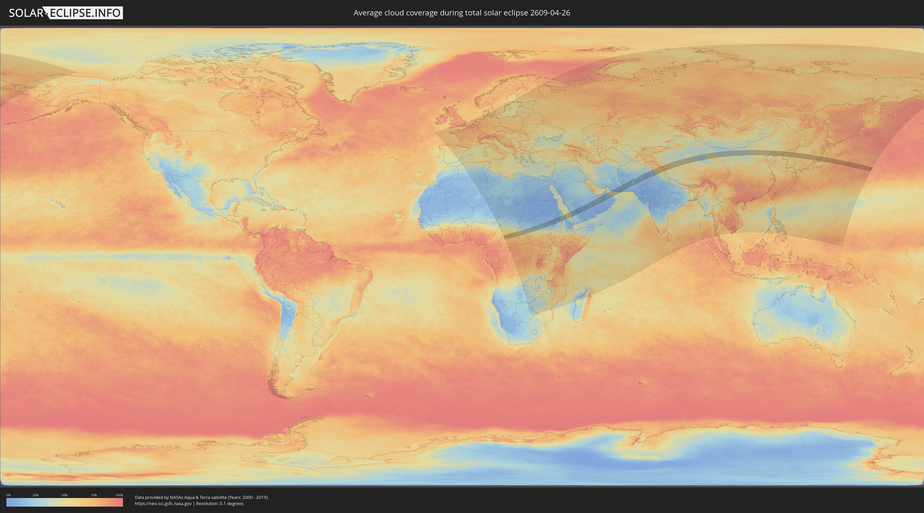
Wie wird das Wetter während der totalen Sonnenfinsternis am 26.04.2609?
Wo ist der beste Ort, um die totale Sonnenfinsternis vom 26.04.2609 zu beobachten?
Die folgenden Karten zeigen die durchschnittliche Bewölkung für den Tag, an dem die totale Sonnenfinsternis
stattfindet. Mit Hilfe der Karten lässt sich der Ort entlang des Finsternispfades eingrenzen,
der die besten Aussichen auf einen klaren wolkenfreien Himmel bietet.
Trotzdem muss man immer lokale Gegenenheiten beachten und sollte sich genau über das Wetter an seinem
gewählten Beobachtungsort informieren.
Die Daten stammen von den beiden NASA-Satelliten
AQUA und TERRA
und wurden über einen Zeitraum von 19 Jahren (2000 - 2019) gemittelt.
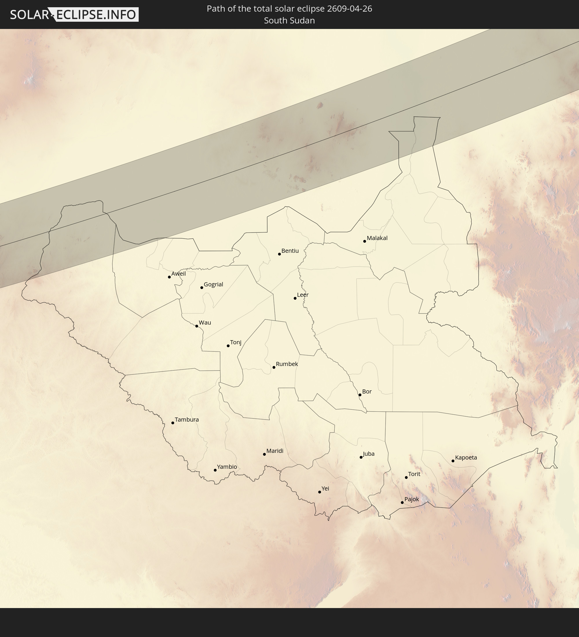
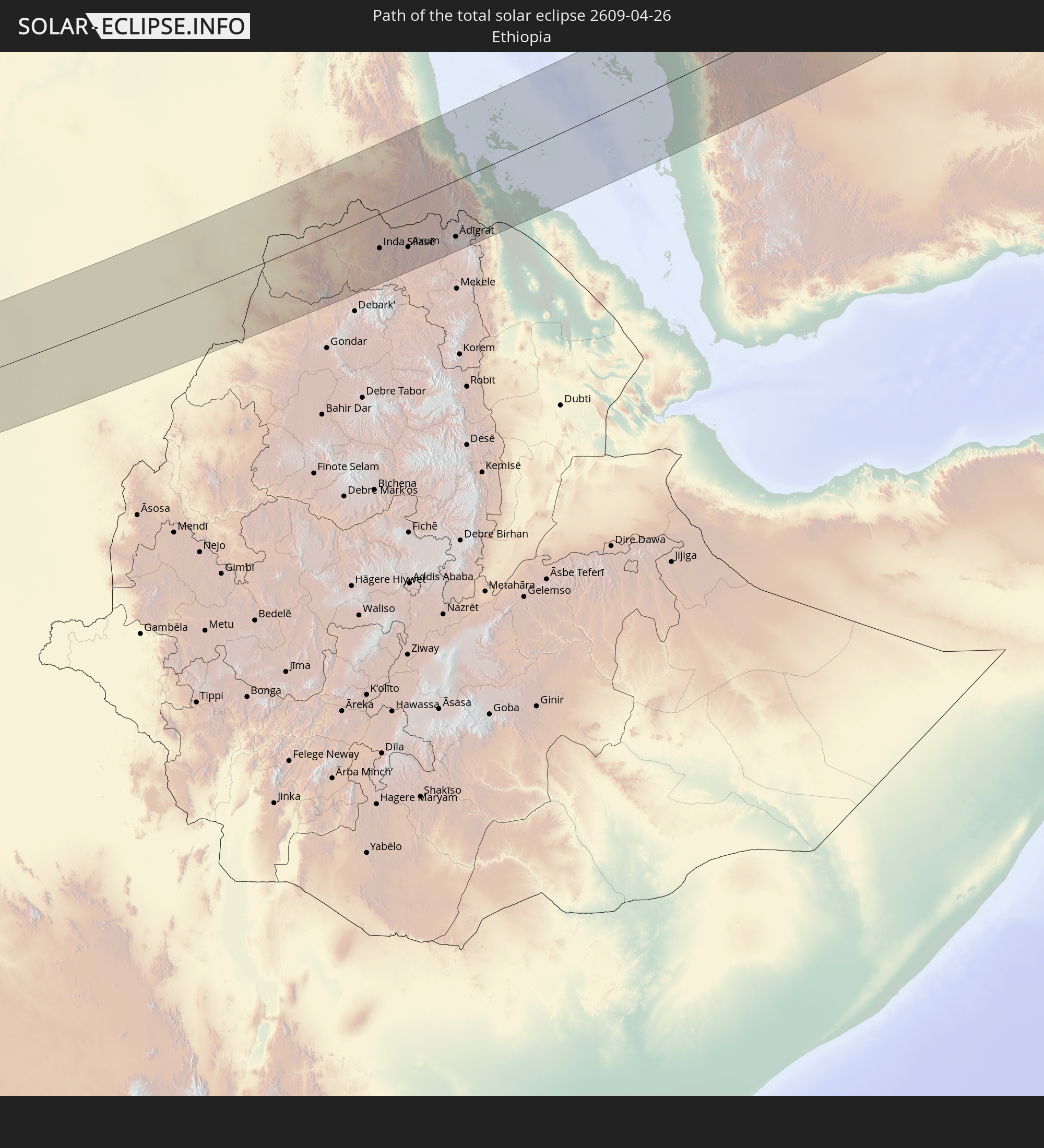
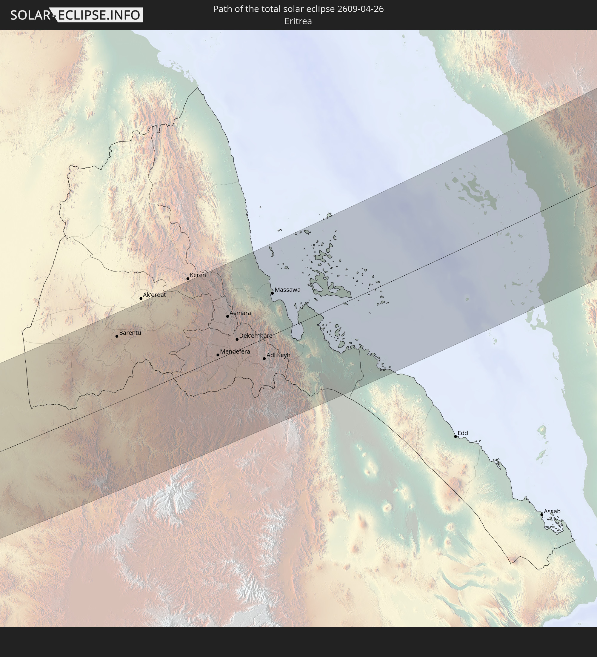
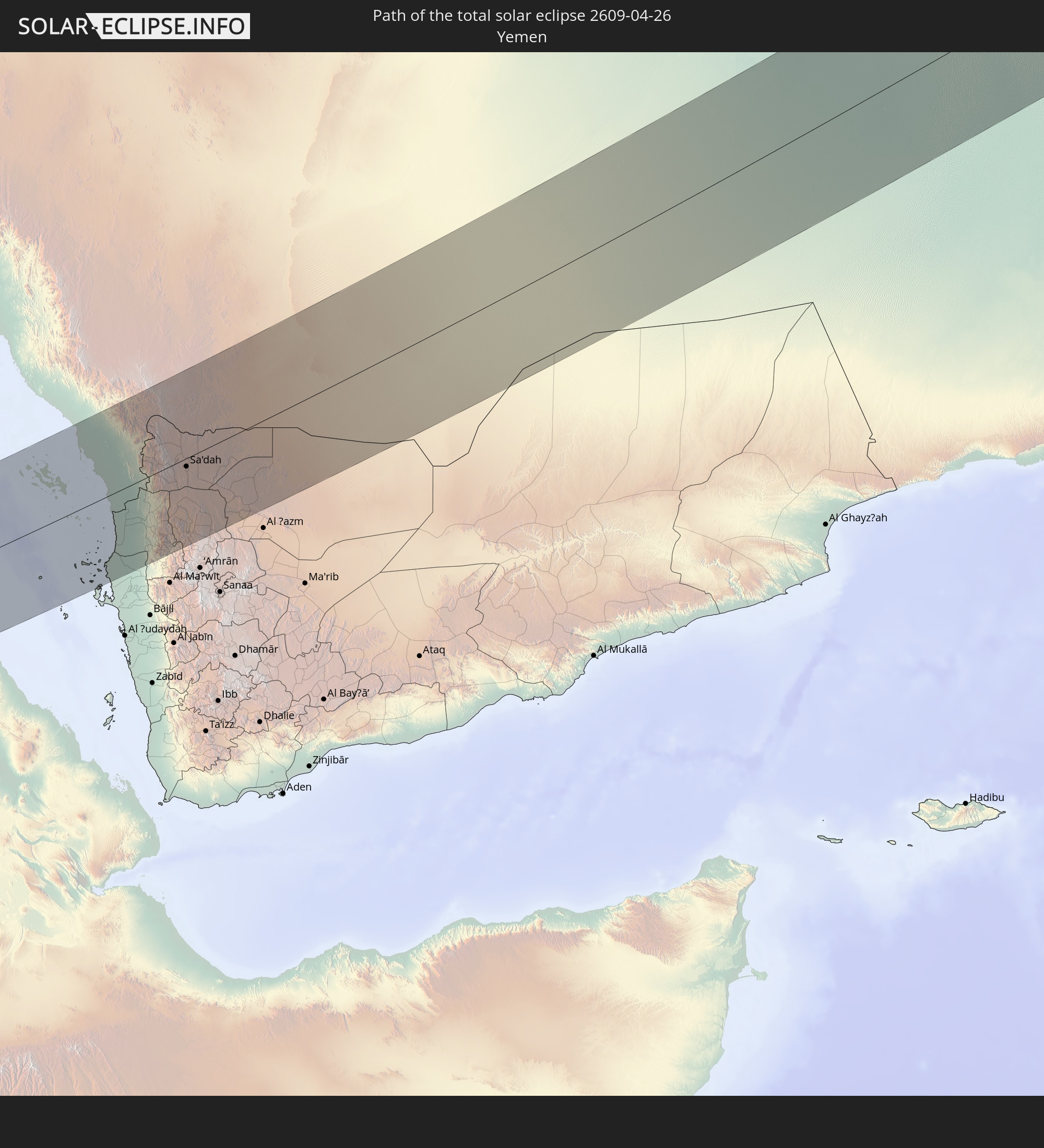
Detaillierte Länderkarten
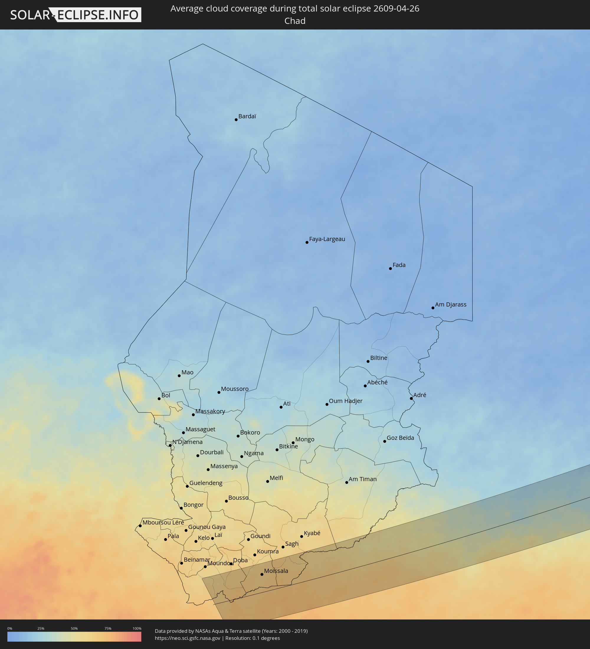 Tschad
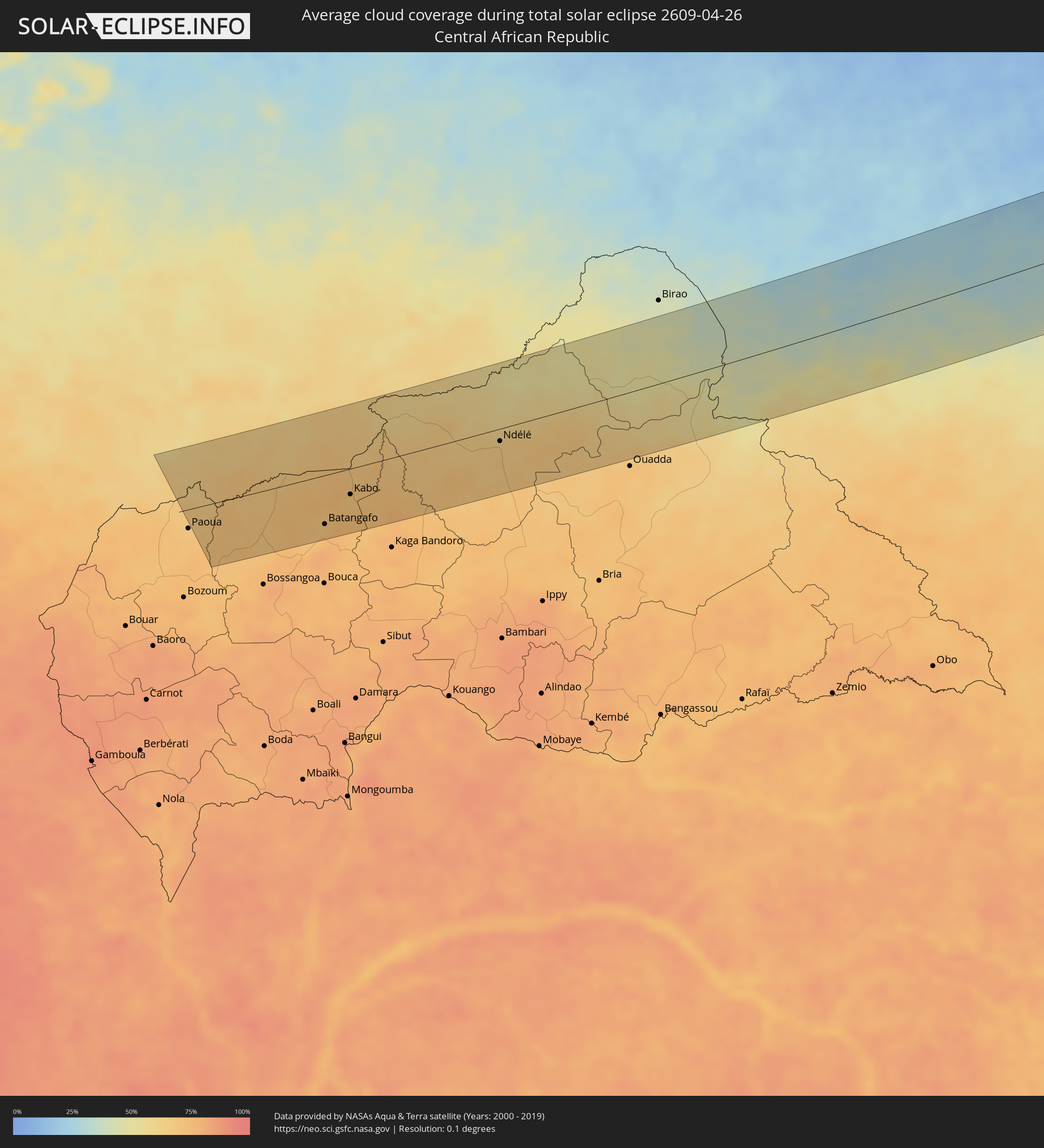 Zentralafrikanische Republik
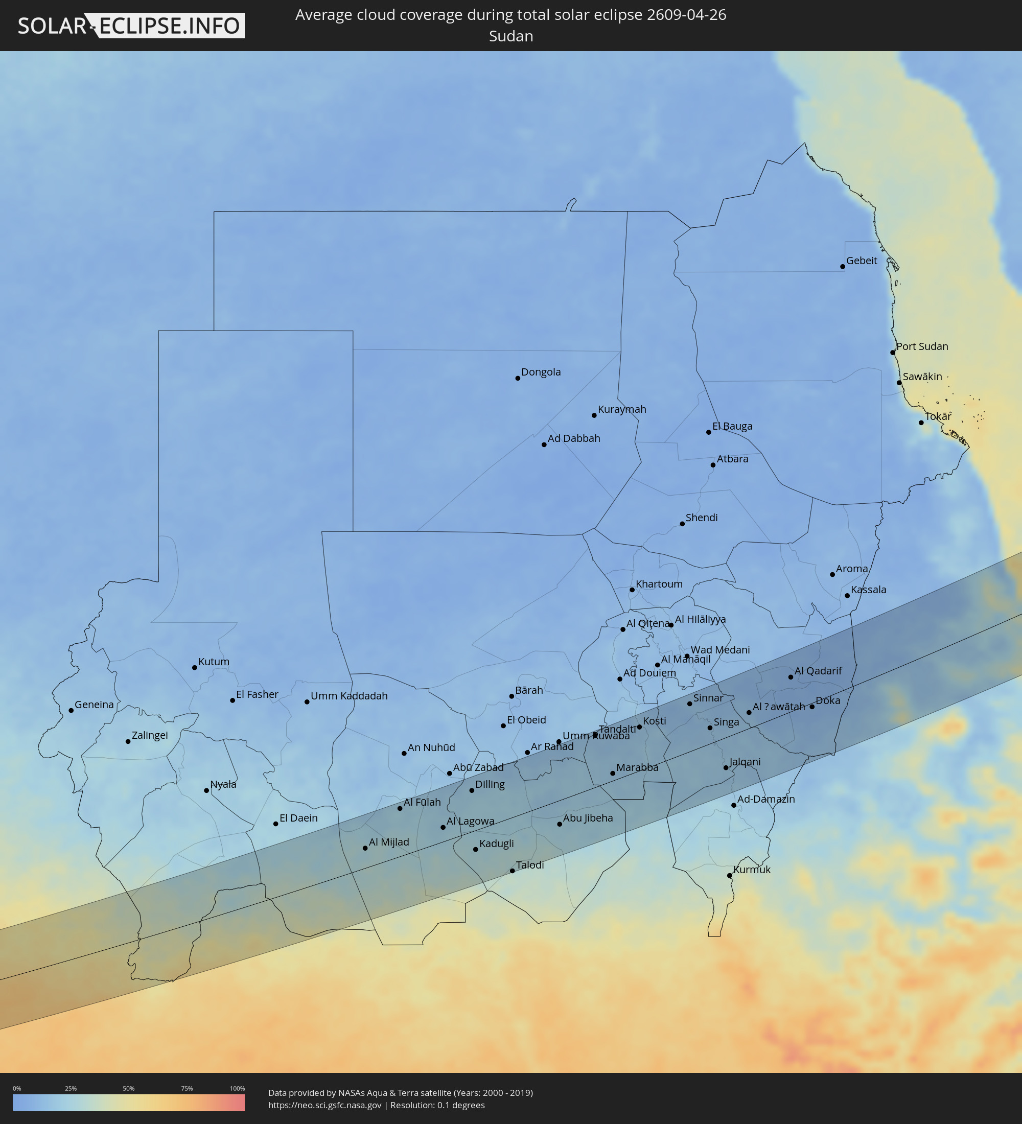 Sudan
Sudan
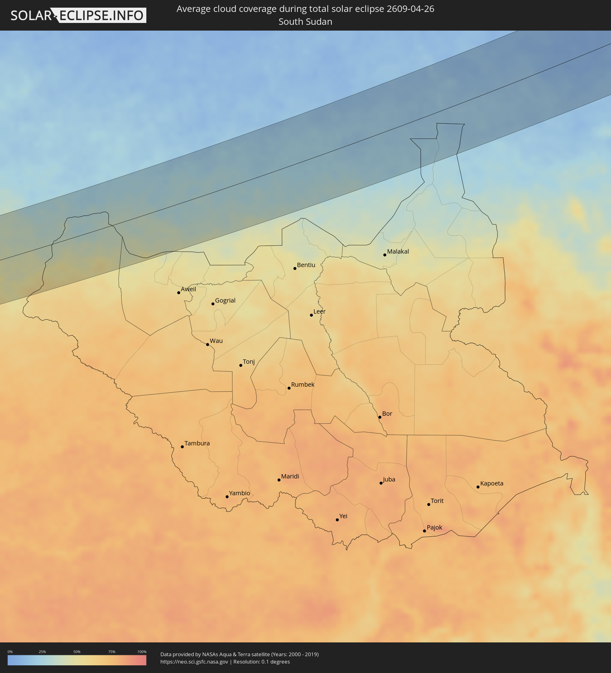 Südsudan
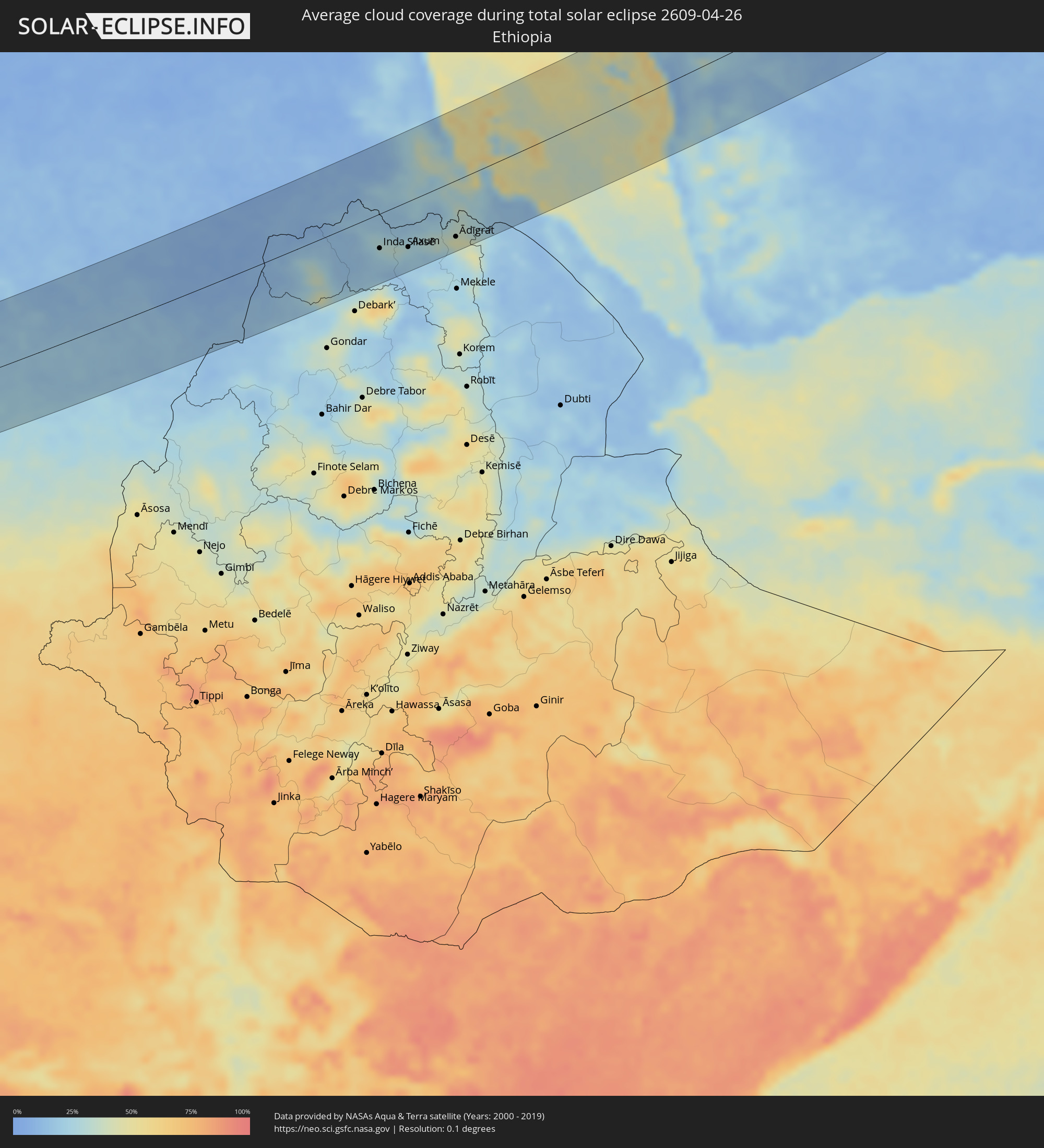 Äthiopien
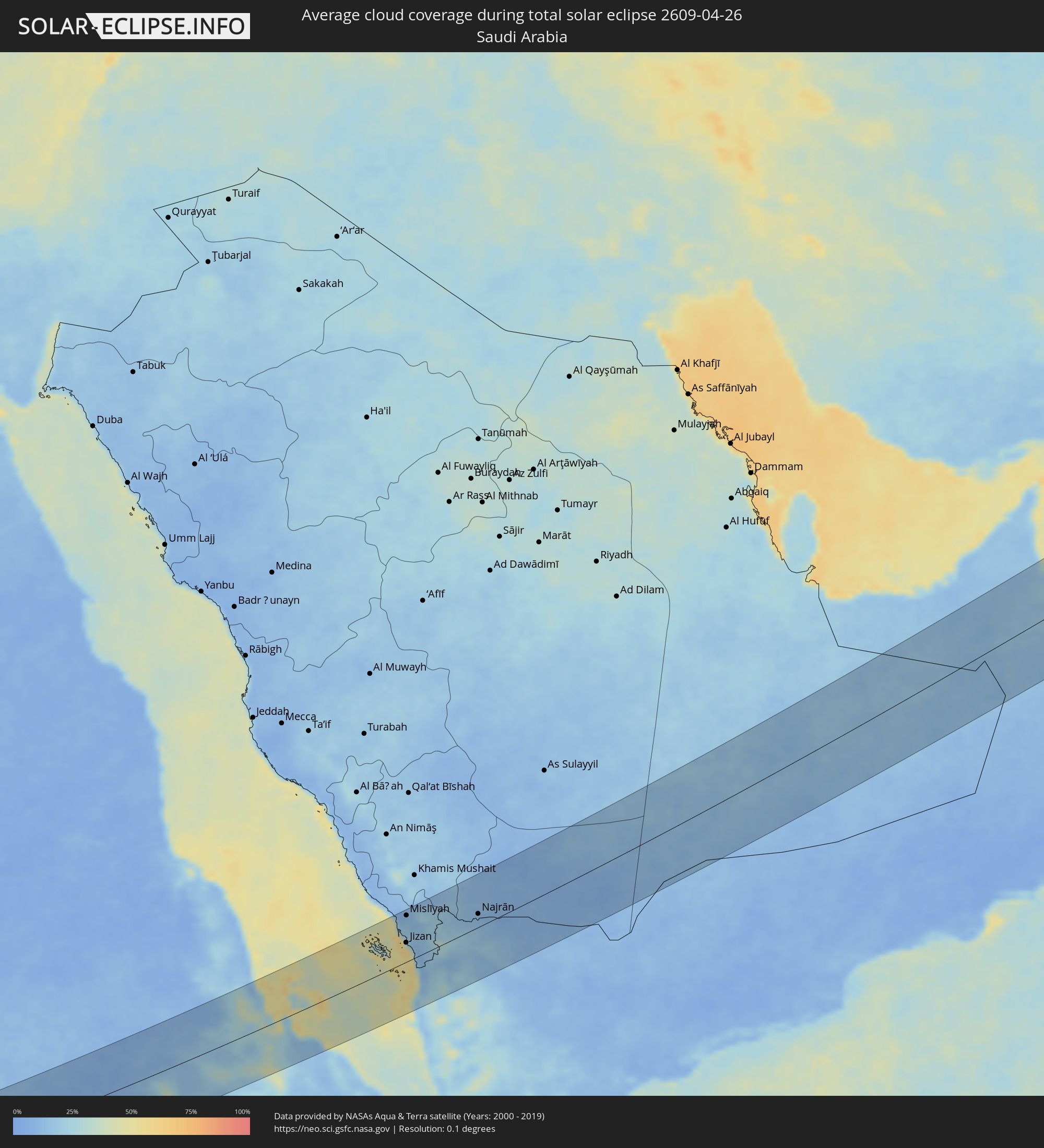 Saudi-Arabien
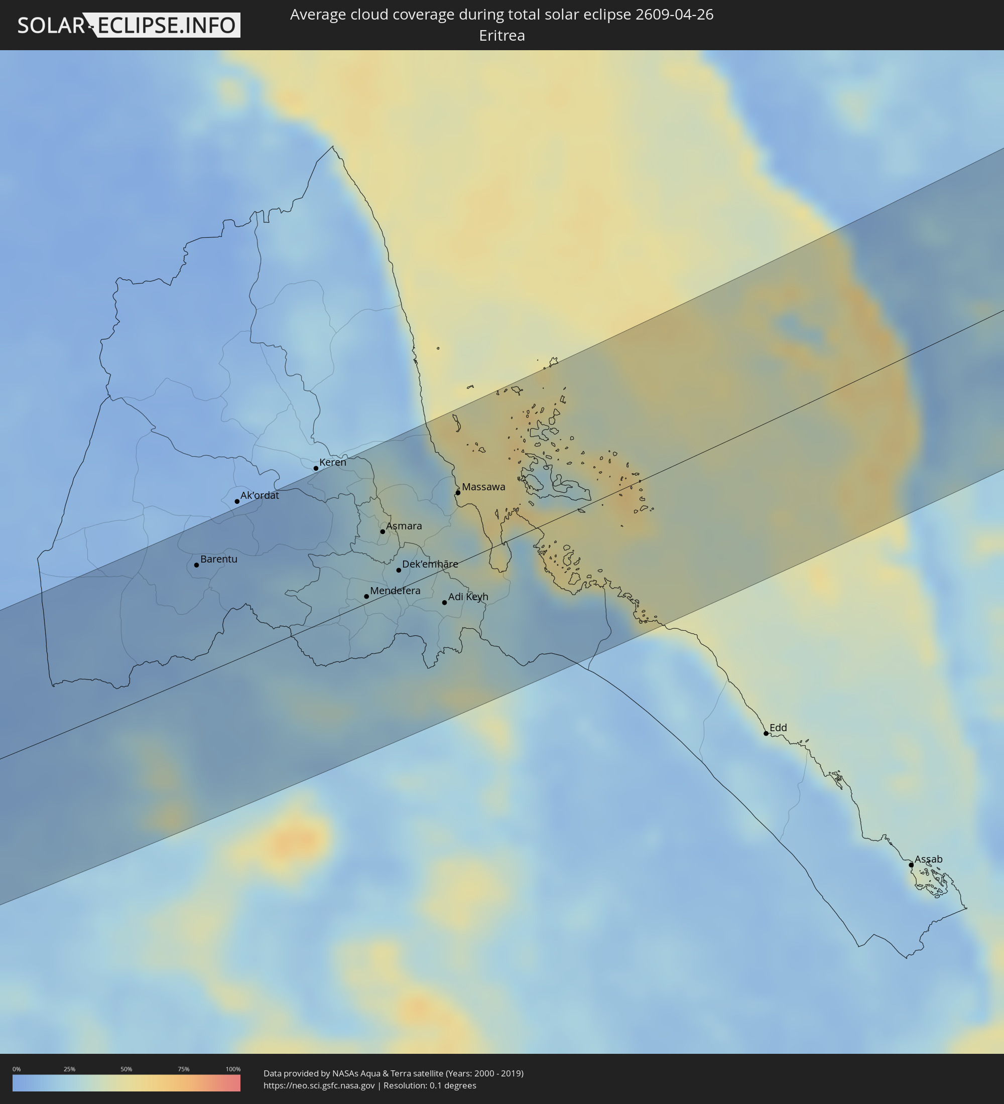 Eritrea
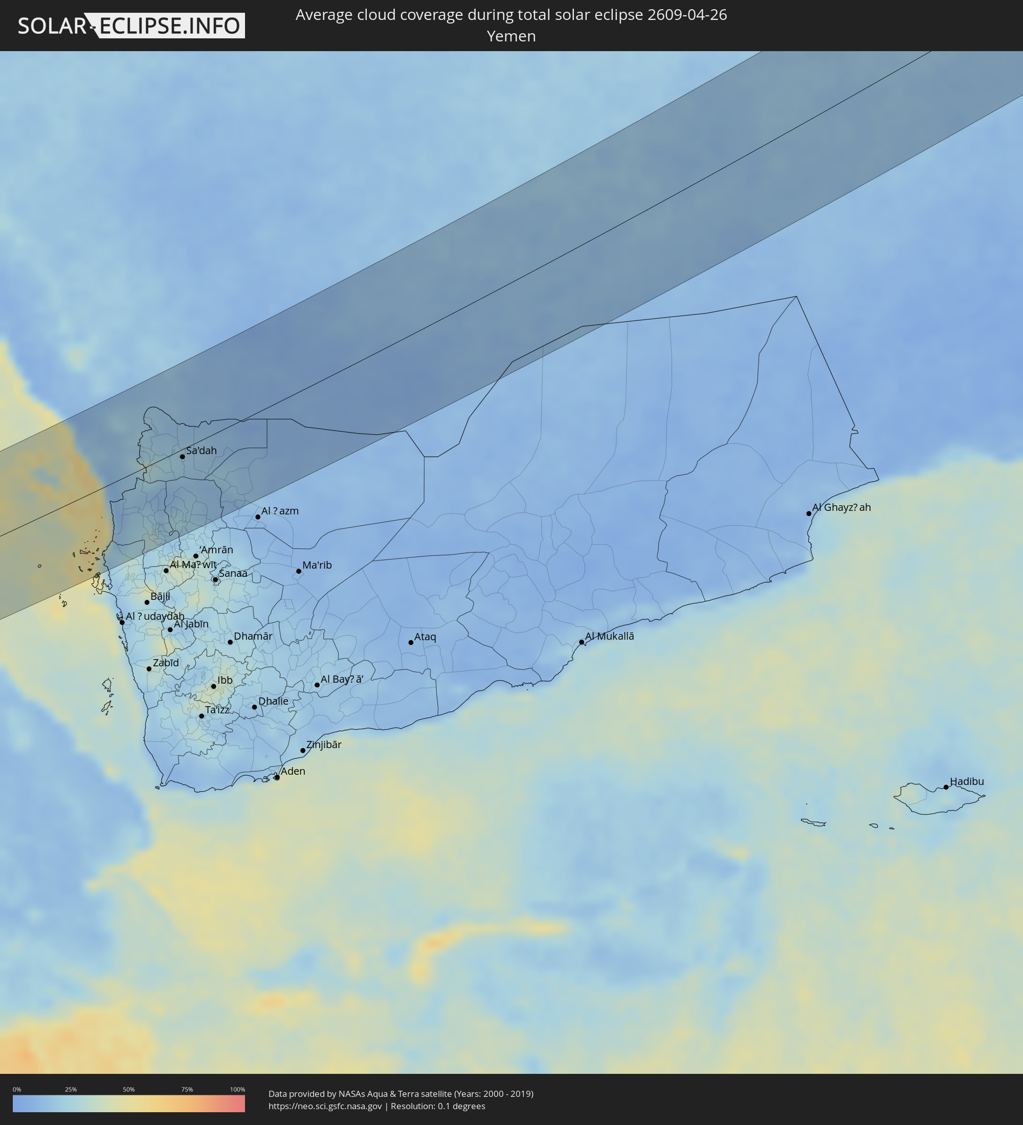 Jemen
Jemen
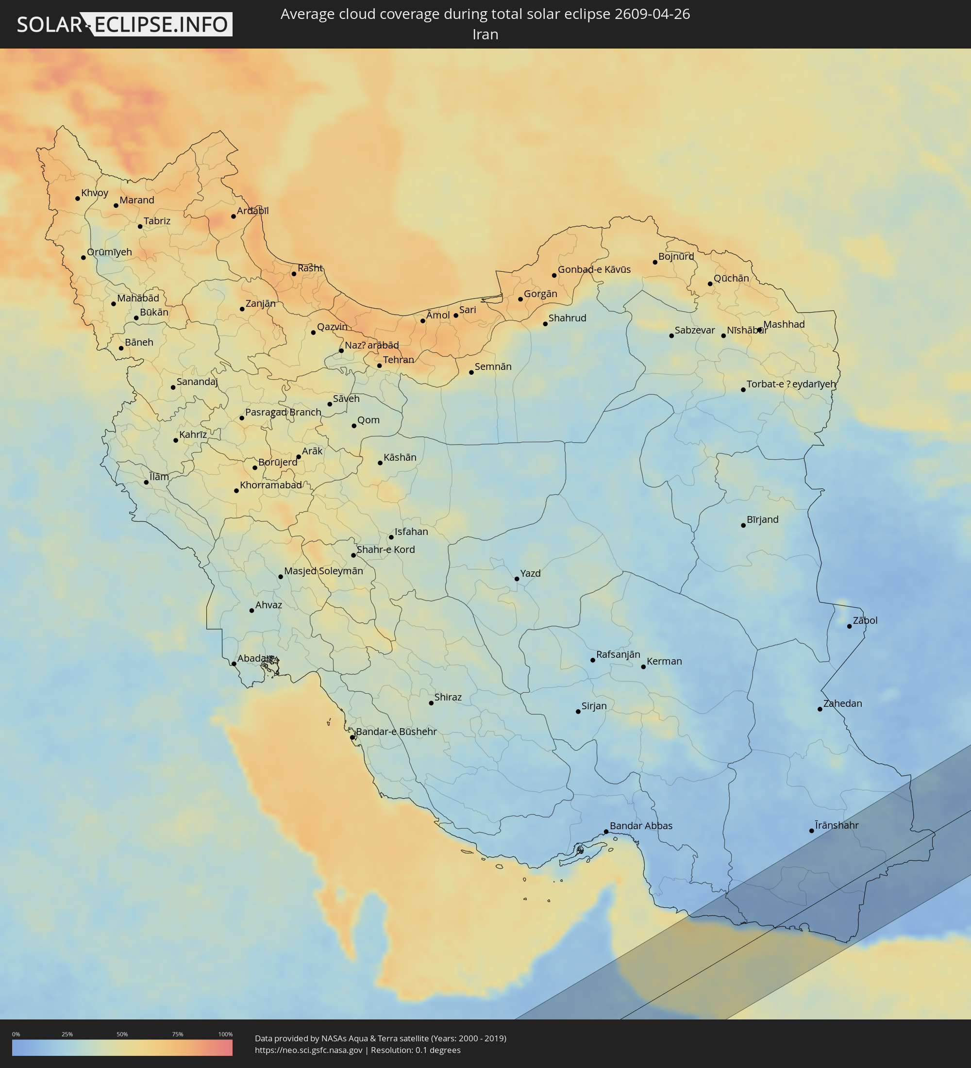 Iran
Iran
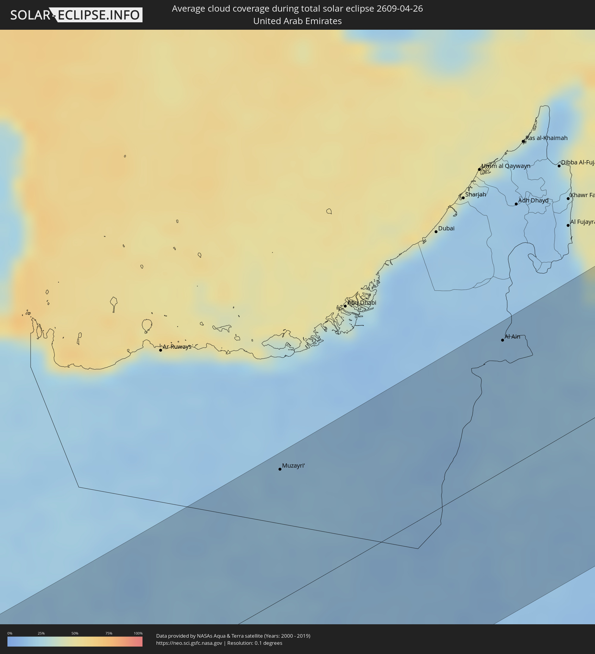 Vereinigte Arabische Emirate
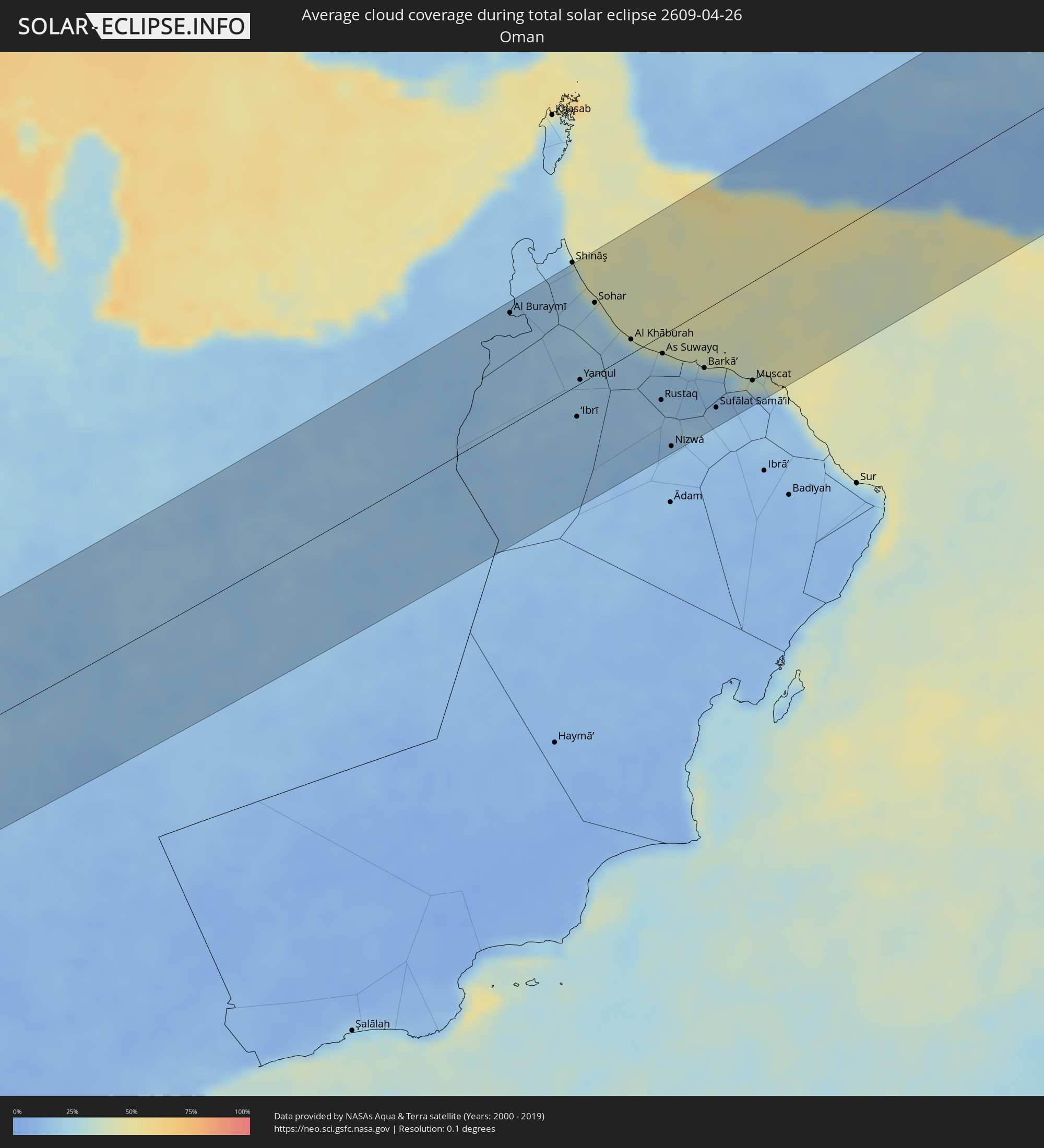 Oman
Oman
 Afghanistan
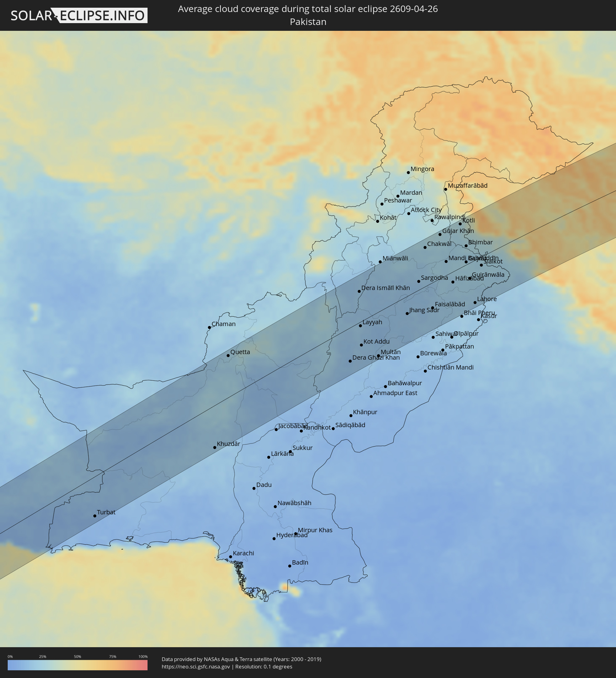 Pakistan
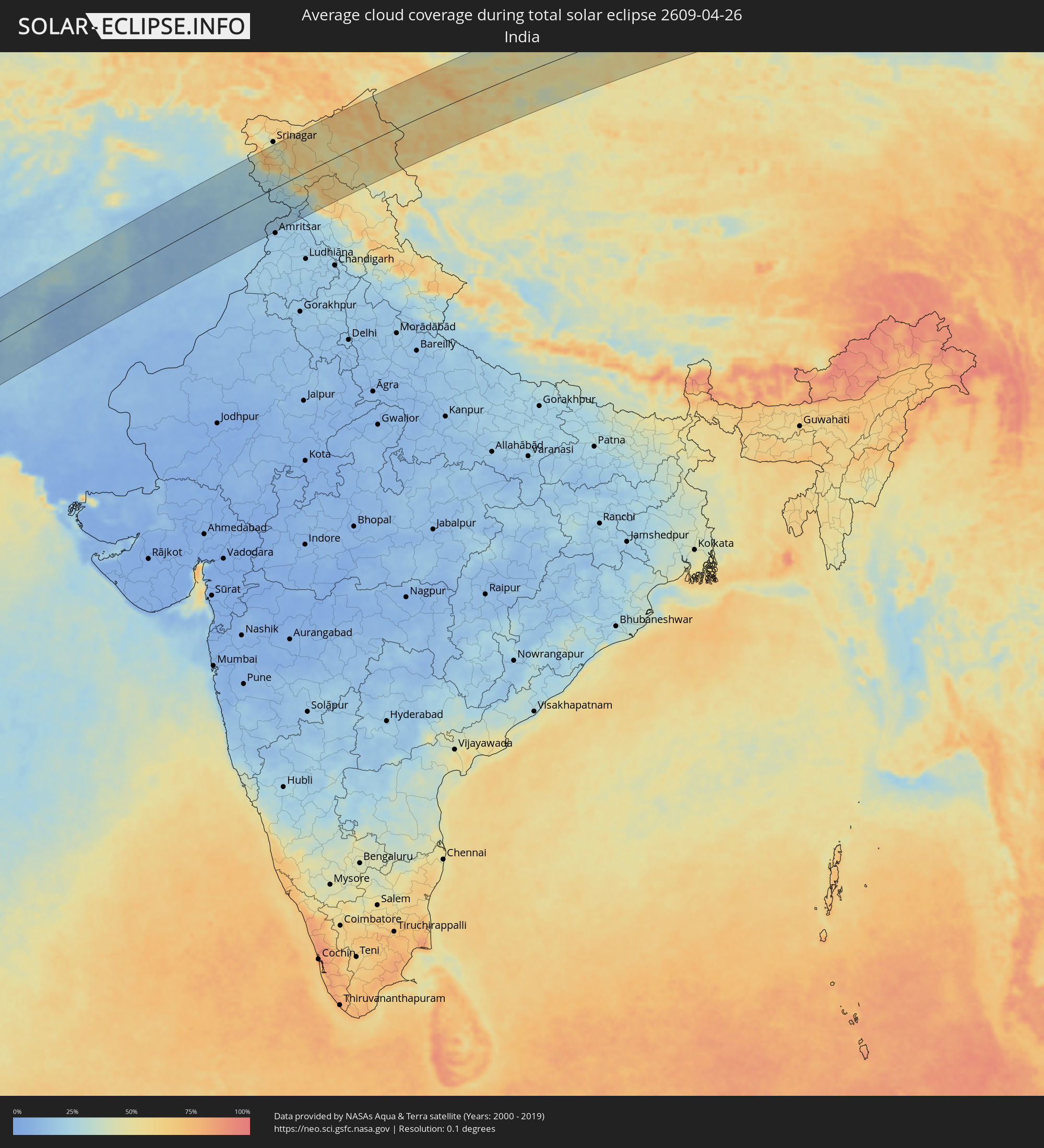 Indien
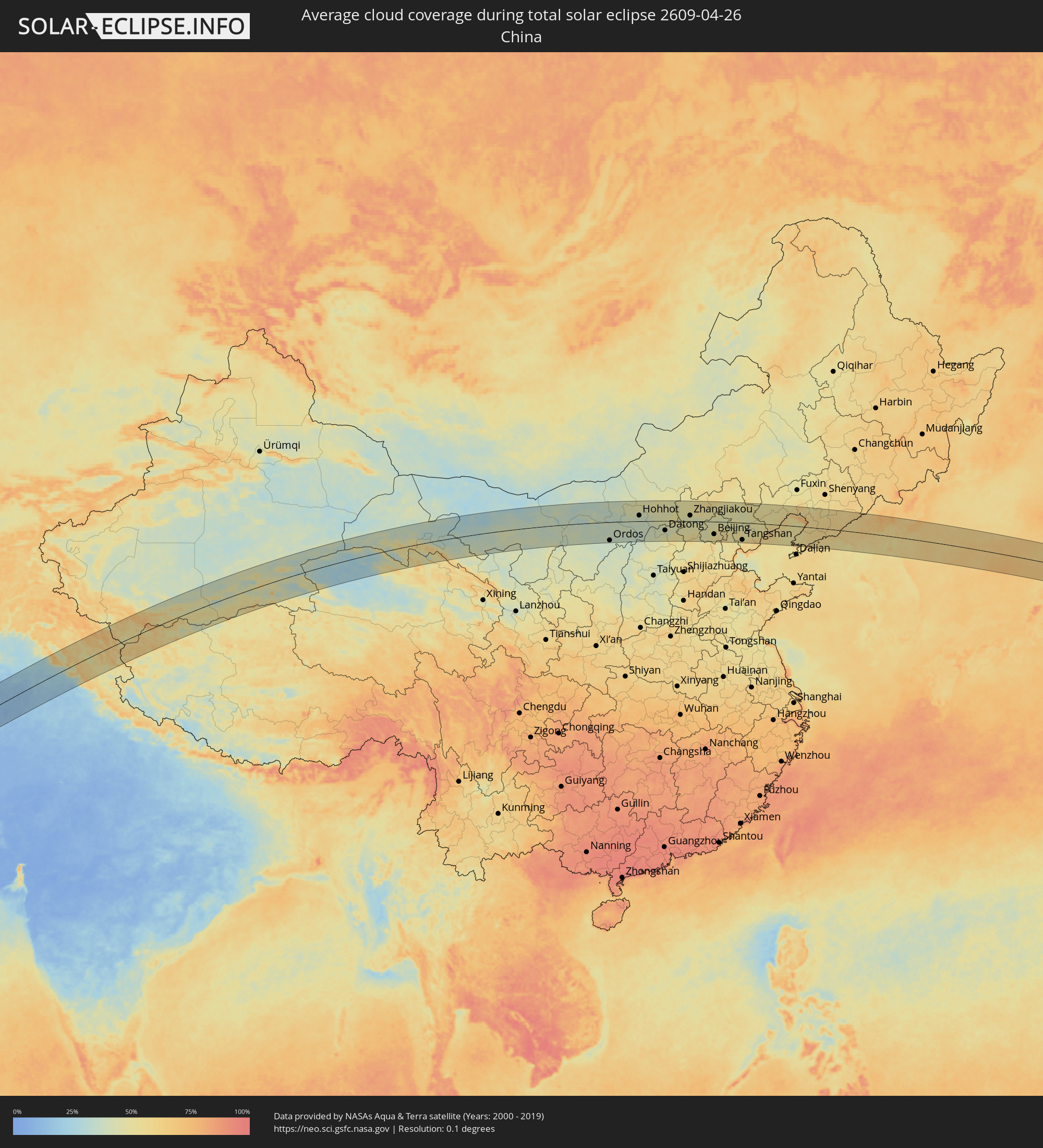 Volksrepublik China
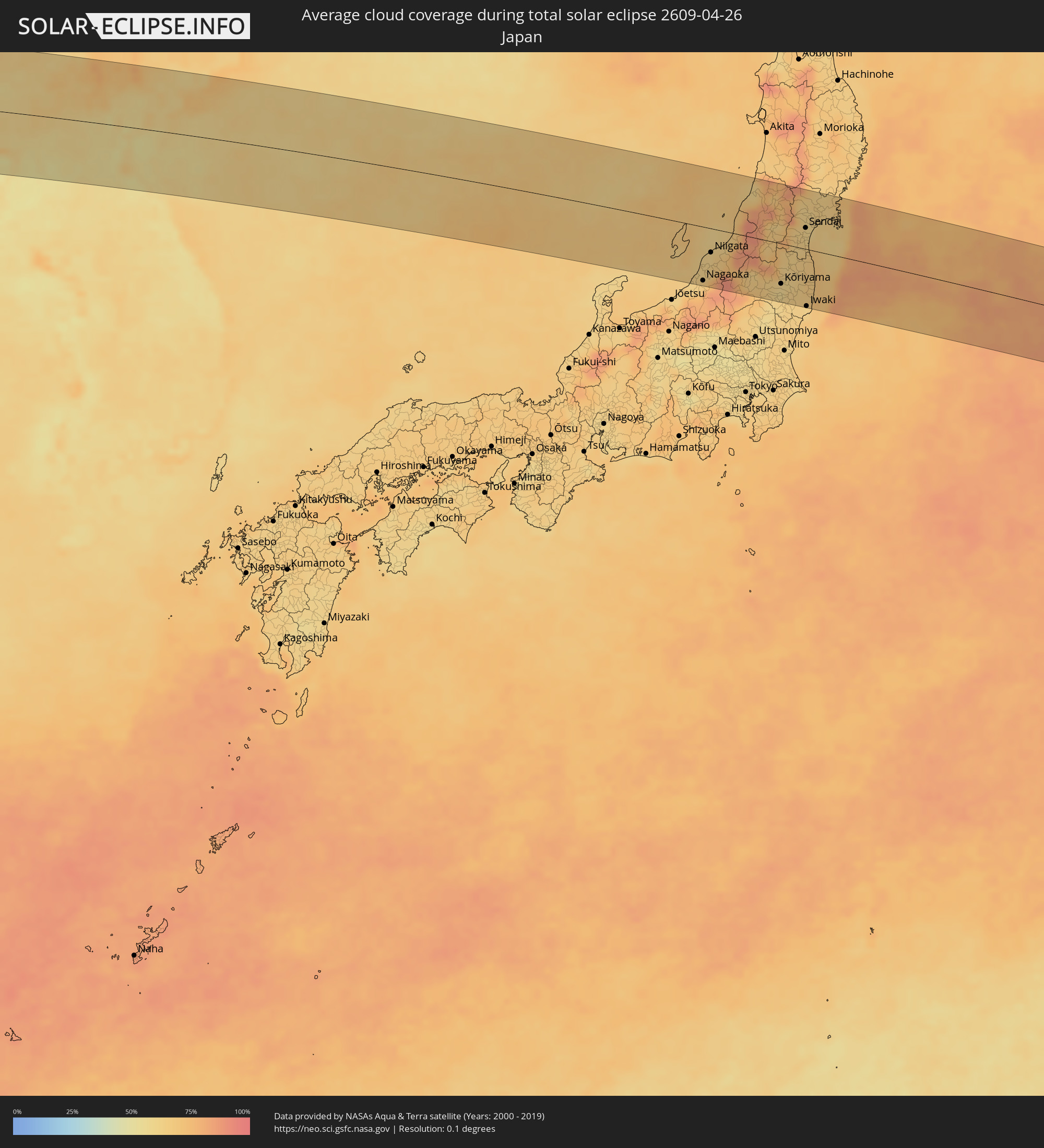 Japan
Japan
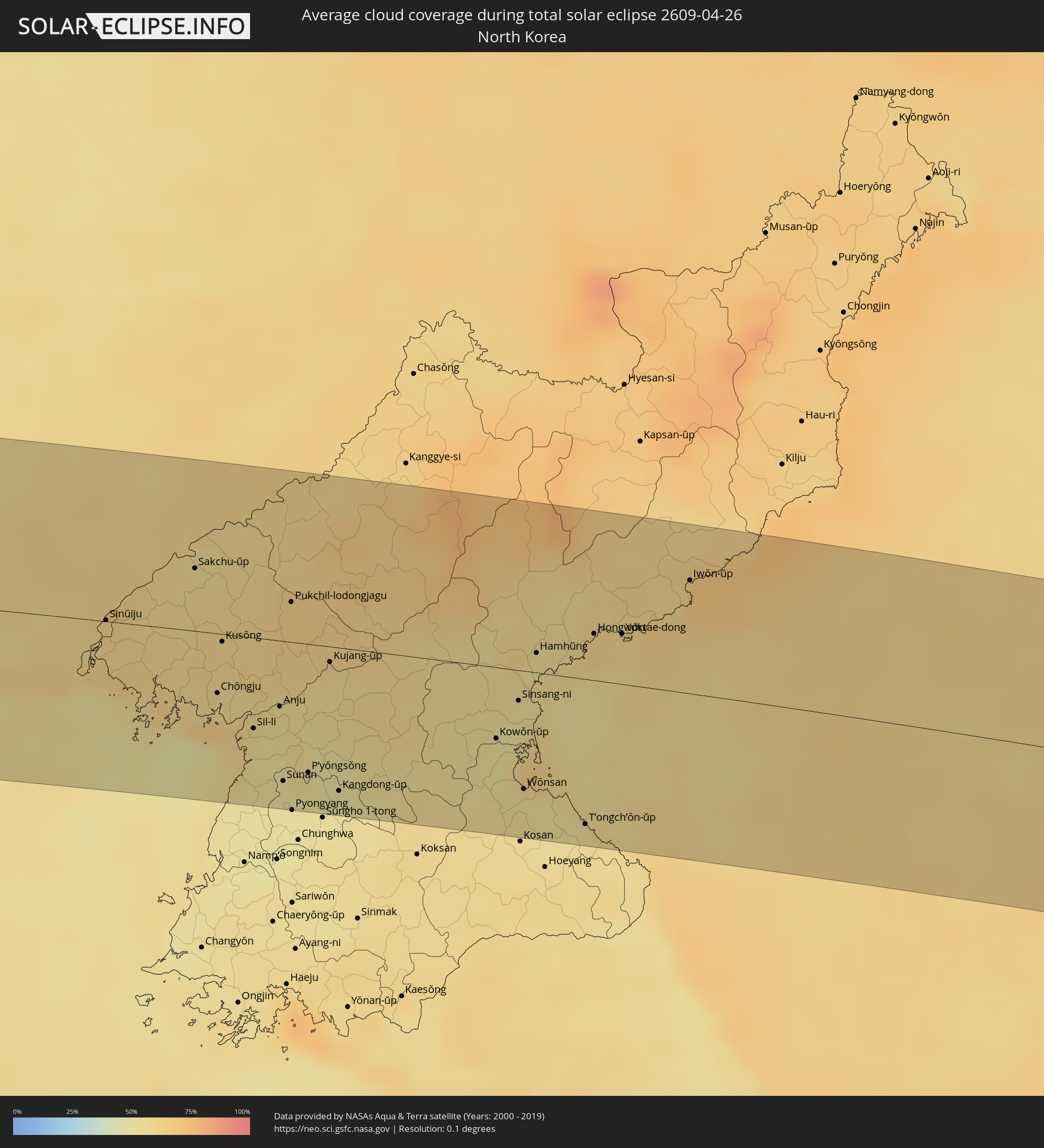 Nordkorea
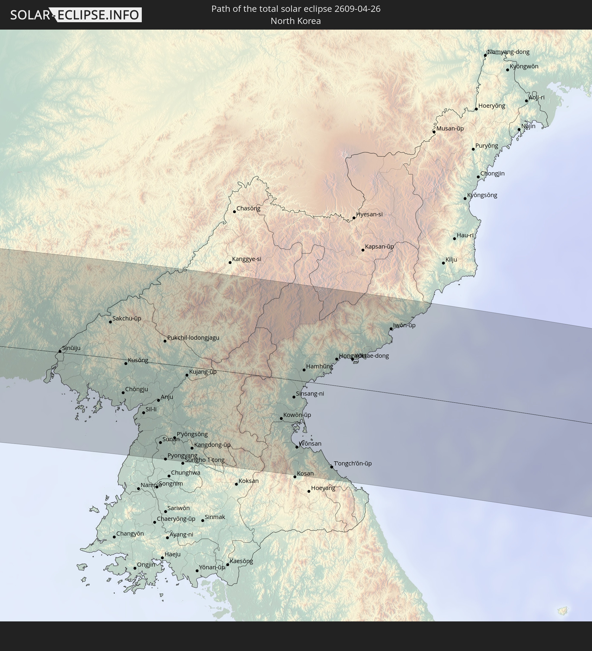
Orte im Finsternispfad
Die nachfolgene Tabelle zeigt Städte und Orte mit mehr als 5.000 Einwohnern, die sich im Finsternispfad befinden. Städte mit mehr als 100.000 Einwohnern sind dick gekennzeichnet. Mit einem Klick auf den Ort öffnet sich eine Detailkarte die die Lage des jeweiligen Ortes zusammen mit dem Verlauf der zentralen Finsternis präsentiert.
| Ort | Typ | Dauer der Verfinsterung | Ortszeit bei maximaler Verfinsterung | Entfernung zur Zentrallinie | Ø Bewölkung |
|
Béboto, Logone Oriental
|
total | - | 05:46:21 UTC+01:00 | 70 km | 63% |
|
Moïssala, Mandoul
|
total | - | 05:46:18 UTC+01:00 | 56 km | 64% |
|
Batangafo, Ouham
|
total | - | 05:45:25 UTC+01:00 | 70 km | 72% |
|
Kabo, Ouham
|
total | - | 05:45:41 UTC+01:00 | 37 km | 70% |
|
Ndélé, Bamingui-Bangoran
|
total | - | 05:46:04 UTC+01:00 | 18 km | 66% |
|
Al Mijlad, West Kordofan State
|
total | - | 06:48:43 UTC+02:00 | 36 km | 26% |
|
Dilling, Southern Kordofan
|
total | - | 06:50:06 UTC+02:00 | 75 km | 22% |
|
Kadugli, Southern Kordofan
|
total | - | 06:49:05 UTC+02:00 | 37 km | 28% |
|
Abu Jibeha, Southern Kordofan
|
total | - | 06:49:54 UTC+02:00 | 45 km | 25% |
|
Tandaltī, White Nile
|
total | - | 06:51:43 UTC+02:00 | 94 km | 15% |
|
Kosti, White Nile
|
total | - | 06:52:08 UTC+02:00 | 78 km | 16% |
|
Sinnar, Sinnār
|
total | - | 06:52:54 UTC+02:00 | 85 km | 14% |
|
Maiurno, Sinnār
|
total | - | 06:52:47 UTC+02:00 | 66 km | 16% |
|
As Sūkī, Sinnār
|
total | - | 06:52:45 UTC+02:00 | 47 km | 15% |
|
Singa, Sinnār
|
total | - | 06:52:35 UTC+02:00 | 27 km | 16% |
|
Ad Dindar, Sinnār
|
total | - | 06:52:44 UTC+02:00 | 23 km | 15% |
|
Al Ḩawātah, Al Qaḑārif
|
total | - | 06:53:09 UTC+02:00 | 27 km | 15% |
|
Al Qadarif, Al Qaḑārif
|
total | - | 06:54:10 UTC+02:00 | 61 km | 7% |
|
Doka, Al Qaḑārif
|
total | - | 06:53:45 UTC+02:00 | 8 km | 8% |
|
Barentu, Gash-Barka
|
total | - | 07:56:30 UTC+03:00 | 79 km | 11% |
|
Inda Silasē, Tigray
|
total | - | 07:55:41 UTC+03:00 | 53 km | 25% |
|
Axum, Tigray
|
total | - | 07:55:57 UTC+03:00 | 70 km | 25% |
|
Mendefera, Debub
|
total | - | 07:56:55 UTC+03:00 | 4 km | 23% |
|
Asmara, Maekel
|
total | - | 07:57:32 UTC+03:00 | 45 km | 30% |
|
Dek’emhāre, Debub
|
total | - | 07:57:17 UTC+03:00 | 13 km | 23% |
|
Adi Keyh, Debub
|
total | - | 07:57:12 UTC+03:00 | 24 km | 27% |
|
Ādīgrat, Tigray
|
total | - | 07:56:34 UTC+03:00 | 86 km | 44% |
|
Massawa, Northern Red Sea
|
total | - | 07:58:12 UTC+03:00 | 49 km | 41% |
|
Farasān, Jizan
|
total | - | 08:01:20 UTC+03:00 | 42 km | 38% |
|
Jizan, Jizan
|
total | - | 08:01:54 UTC+03:00 | 41 km | 33% |
|
Mislīyah, Jizan
|
total | - | 08:02:39 UTC+03:00 | 98 km | 12% |
|
Şabyā, Jizan
|
total | - | 08:02:18 UTC+03:00 | 63 km | 19% |
|
Mizhirah, Jizan
|
total | - | 08:01:57 UTC+03:00 | 26 km | 28% |
|
Abū ‘Arīsh, Jizan
|
total | - | 08:02:13 UTC+03:00 | 36 km | 14% |
|
Al Jarādīyah, Jizan
|
total | - | 08:01:46 UTC+03:00 | 7 km | 11% |
|
Şāmitah, Jizan
|
total | - | 08:01:49 UTC+03:00 | 7 km | 11% |
|
Sa'dah, Şa‘dah
|
total | - | 08:02:54 UTC+03:00 | 10 km | 19% |
|
Najrān, Najran
|
total | - | 08:03:56 UTC+03:00 | 28 km | 13% |
|
Muzayri‘, Abu Dhabi
|
total | - | 09:22:12 UTC+04:00 | 103 km | 15% |
|
Al Ain, Abu Dhabi
|
total | - | 09:26:27 UTC+04:00 | 102 km | 14% |
|
Al Buraymī, Al Buraimi
|
total | - | 09:26:35 UTC+04:00 | 106 km | 15% |
|
‘Ibrī, Az̧ Z̧āhirah
|
total | - | 09:25:59 UTC+04:00 | 30 km | 16% |
|
Al Liwā’, Al Batinah North Governorate
|
total | - | 09:28:06 UTC+04:00 | 93 km | 24% |
|
Sohar, Al Batinah North Governorate
|
total | - | 09:28:01 UTC+04:00 | 68 km | 24% |
|
Şaḩam, Al Batinah North Governorate
|
total | - | 09:27:59 UTC+04:00 | 42 km | 31% |
|
Al Khābūrah, Al Batinah North Governorate
|
total | - | 09:28:00 UTC+04:00 | 13 km | 23% |
|
Bahlā’, Muḩāfaz̧at ad Dākhilīyah
|
total | - | 09:26:42 UTC+04:00 | 94 km | 12% |
|
Rustaq, Al Batinah South Governorate
|
total | - | 09:27:32 UTC+04:00 | 61 km | 17% |
|
As Suwayq, Al Batinah North Governorate
|
total | - | 09:28:16 UTC+04:00 | 18 km | 15% |
|
Nizwá, Muḩāfaz̧at ad Dākhilīyah
|
total | - | 09:26:58 UTC+04:00 | 110 km | 13% |
|
Barkā’, Al Batinah South Governorate
|
total | - | 09:28:42 UTC+04:00 | 55 km | 15% |
|
Sufālat Samā’il, Muḩāfaz̧at ad Dākhilīyah
|
total | - | 09:28:17 UTC+04:00 | 99 km | 16% |
|
Seeb, Muḩāfaz̧at Masqaţ
|
total | - | 09:29:05 UTC+04:00 | 74 km | 25% |
|
Muscat, Muḩāfaz̧at Masqaţ
|
total | - | 09:29:16 UTC+04:00 | 93 km | 14% |
|
Chabahar, Sistan and Baluchestan
|
total | - | 09:05:24 UTC+03:30 | 45 km | 48% |
|
Qaşr-e Qand, Sistan and Baluchestan
|
total | - | 09:07:06 UTC+03:30 | 40 km | 12% |
|
Quetta, Balochistān
|
total | - | 10:53:59 UTC+05:00 | 103 km | 21% |
|
Dera Ghazi Khan, Punjab
|
total | - | 11:00:40 UTC+05:00 | 84 km | 13% |
|
Multān, Punjab
|
total | - | 11:02:33 UTC+05:00 | 110 km | 14% |
|
Jhang Sadr, Punjab
|
total | - | 11:05:46 UTC+05:00 | 44 km | 15% |
|
Sargodha, Punjab
|
total | - | 11:07:33 UTC+05:00 | 20 km | 15% |
|
Chiniot, Punjab
|
total | - | 11:07:41 UTC+05:00 | 29 km | 15% |
|
Faisalābād, Punjab
|
total | - | 11:07:29 UTC+05:00 | 64 km | 18% |
|
Kotli, Azad Kashmir
|
total | - | 11:11:54 UTC+05:00 | 107 km | 26% |
|
Sheikhupura, Punjab
|
total | - | 11:09:42 UTC+05:00 | 74 km | 19% |
|
Bhimbar, Azad Kashmir
|
total | - | 11:11:34 UTC+05:00 | 46 km | 26% |
|
Gujrāt, Punjab
|
total | - | 11:11:02 UTC+05:00 | 6 km | 25% |
|
Gujrānwāla, Punjab
|
total | - | 11:10:44 UTC+05:00 | 39 km | 21% |
|
Rajaori, Kashmir
|
total | - | 11:42:32 UTC+05:30 | 75 km | 30% |
|
Lahore, Punjab
|
total | - | 11:10:15 UTC+05:00 | 106 km | 16% |
|
Sialkot, Punjab
|
total | - | 11:11:51 UTC+05:00 | 21 km | 23% |
|
Jammu, Kashmir
|
total | - | 11:42:52 UTC+05:30 | 12 km | 24% |
|
Pulwama, Kashmir
|
total | - | 11:44:21 UTC+05:30 | 100 km | 45% |
|
Sāmba, Kashmir
|
total | - | 11:43:09 UTC+05:30 | 40 km | 23% |
|
Udhampur, Kashmir
|
total | - | 11:43:39 UTC+05:30 | 5 km | 26% |
|
Anantnag, Kashmir
|
total | - | 11:44:41 UTC+05:30 | 75 km | 44% |
|
Dhāriwāl, Punjab
|
total | - | 11:42:48 UTC+05:30 | 109 km | 20% |
|
Dīnānagar, Punjab
|
total | - | 11:43:21 UTC+05:30 | 97 km | 20% |
|
Kathua, Kashmir
|
total | - | 11:43:45 UTC+05:30 | 76 km | 22% |
|
Pathānkot, Punjab
|
total | - | 11:43:54 UTC+05:30 | 91 km | 19% |
|
Kishtwār, Kashmir
|
total | - | 11:45:26 UTC+05:30 | 7 km | 48% |
|
Chamba, Himachal Pradesh
|
total | - | 11:45:14 UTC+05:30 | 83 km | 37% |
|
Padam, Kashmir
|
total | - | 11:47:55 UTC+05:30 | 24 km | 48% |
|
Leh, Kashmir
|
total | - | 11:50:11 UTC+05:30 | 18 km | 54% |
|
Ordos, Inner Mongolia
|
total | - | 15:24:02 UTC+08:00 | 98 km | 35% |
|
Baotou, Inner Mongolia
|
total | - | 15:23:35 UTC+08:00 | 18 km | 34% |
|
Hohhot, Inner Mongolia
|
total | - | 15:26:02 UTC+08:00 | 31 km | 41% |
|
Datong, Shanxi
|
total | - | 15:28:37 UTC+08:00 | 51 km | 44% |
|
Zhangjiakou, Hebei
|
total | - | 15:30:11 UTC+08:00 | 30 km | 44% |
|
Beijing, Beijing
|
total | - | 15:32:37 UTC+08:00 | 68 km | 51% |
|
Chengde, Hebei
|
total | - | 15:33:42 UTC+08:00 | 53 km | 47% |
|
Tangshan, Hebei
|
total | - | 15:34:54 UTC+08:00 | 92 km | 52% |
|
Qinhuangdao, Hebei
|
total | - | 15:36:14 UTC+08:00 | 52 km | 62% |
|
Jinzhou, Liaoning
|
total | - | 15:36:56 UTC+08:00 | 87 km | 54% |
|
Panshan, Liaoning
|
total | - | 15:37:45 UTC+08:00 | 102 km | 57% |
|
Yingkou, Liaoning
|
total | - | 15:38:21 UTC+08:00 | 46 km | 73% |
|
Anshan, Liaoning
|
total | - | 15:38:41 UTC+08:00 | 102 km | 56% |
|
Dandong, Liaoning
|
total | - | 15:40:48 UTC+08:00 | 4 km | 60% |
|
Sinŭiju, P'yŏngan-bukto
|
total | - | 16:40:49 UTC+09:00 | 1 km | 60% |
|
Ŭiju, P'yŏngan-bukto
|
total | - | 16:40:51 UTC+09:00 | 13 km | 65% |
|
Chŏngju, P'yŏngan-bukto
|
total | - | 16:41:53 UTC+09:00 | 37 km | 58% |
|
Kusŏng, P'yŏngan-bukto
|
total | - | 16:41:40 UTC+09:00 | 5 km | 60% |
|
Anju, P'yŏngan-namdo
|
total | - | 16:42:20 UTC+09:00 | 41 km | 54% |
|
Sunan, Pyongyang
|
total | - | 16:42:42 UTC+09:00 | 87 km | 51% |
|
Pyongyang, Pyongyang
|
partiell | - | 16:42:54 UTC+09:00 | 104 km | 50% |
|
P’yŏngsŏng, P'yŏngan-namdo
|
total | - | 16:42:49 UTC+09:00 | 80 km | 53% |
|
Kangdong-ŭp, Pyongyang
|
total | - | 16:43:06 UTC+09:00 | 89 km | 51% |
|
Wŏnsan, Kangwŏn-do
|
total | - | 16:44:11 UTC+09:00 | 73 km | 55% |
|
Hamhŭng, Hamgyŏng-namdo
|
total | - | 16:43:36 UTC+09:00 | 12 km | 52% |
|
Hongwŏn, Hamgyŏng-namdo
|
total | - | 16:43:49 UTC+09:00 | 29 km | 62% |
|
Yuktae-dong, Hamgyŏng-namdo
|
total | - | 16:43:59 UTC+09:00 | 31 km | 59% |
|
Iwŏn-ŭp, Hamgyŏng-namdo
|
total | - | 16:44:05 UTC+09:00 | 70 km | 69% |
|
Nagaoka, Niigata
|
total | - | 16:52:26 UTC+09:00 | 91 km | 67% |
|
Sanjō, Niigata
|
total | - | 16:52:20 UTC+09:00 | 71 km | 66% |
|
Niigata, Niigata
|
total | - | 16:52:07 UTC+09:00 | 40 km | 62% |
|
Shibata, Niigata
|
total | - | 16:52:11 UTC+09:00 | 28 km | 63% |
|
Tsuruoka, Yamagata
|
total | - | 16:51:40 UTC+09:00 | 65 km | 71% |
|
Sakata, Yamagata
|
total | - | 16:51:30 UTC+09:00 | 87 km | 63% |
|
Yonezawa, Yamagata
|
total | - | 16:52:31 UTC+09:00 | 17 km | 69% |
|
Yamagata, Yamagata
|
total | - | 16:52:18 UTC+09:00 | 22 km | 78% |
|
Kōriyama, Fukushima
|
total | - | 16:53:04 UTC+09:00 | 68 km | 58% |
|
Fukushima, Fukushima
|
total | - | 16:52:47 UTC+09:00 | 28 km | 62% |
|
Sendai, Miyagi
|
total | - | 16:52:27 UTC+09:00 | 36 km | 61% |
|
Iwaki, Fukushima
|
total | - | 16:53:33 UTC+09:00 | 96 km | 62% |
|
Furukawa, Miyagi
|
total | - | 16:52:12 UTC+09:00 | 70 km | 62% |
|
Ishinomaki, Miyagi
|
total | - | 16:52:27 UTC+09:00 | 60 km | 65% |