Annular solar eclipse of 04/07/-0023
| Day of week: | Wednesday |
| Maximum duration of eclipse: | 05m23s |
| Maximum width of eclipse path: | 285 km |
| Saros cycle: | 77 |
| Coverage: | 94.3% |
| Magnitude: | 0.9425 |
| Gamma: | 0.6856 |
Wo kann man die Sonnenfinsternis vom 04/07/-0023 sehen?
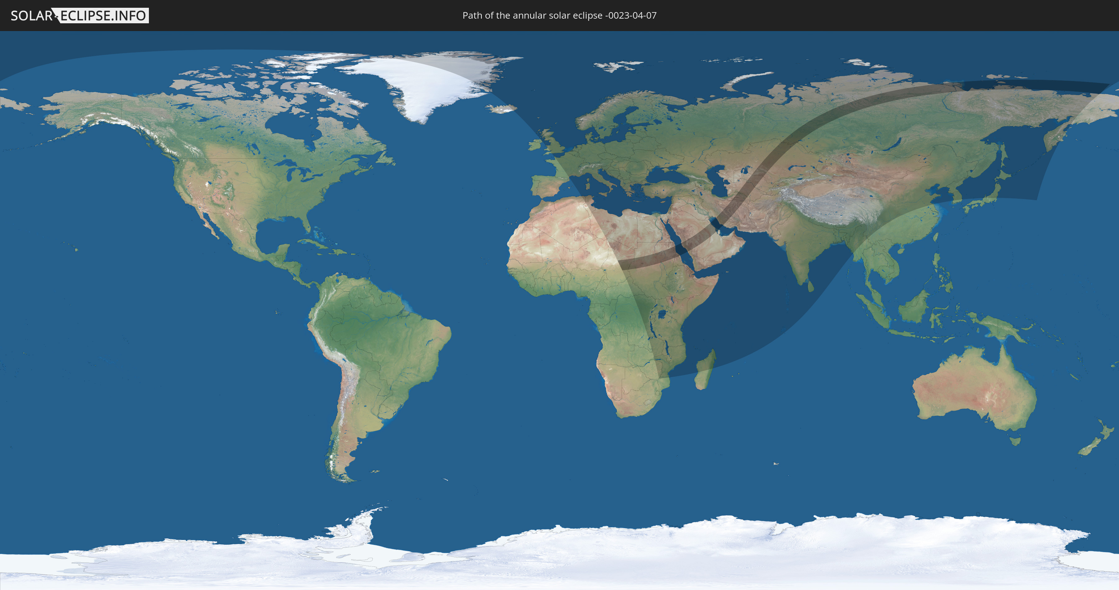
Die Sonnenfinsternis am 04/07/-0023 kann man in 112 Ländern als partielle Sonnenfinsternis beobachten.
Der Finsternispfad verläuft durch 10 Länder. Nur in diesen Ländern ist sie als annular Sonnenfinsternis zu sehen.
In den folgenden Ländern ist die Sonnenfinsternis annular zu sehen
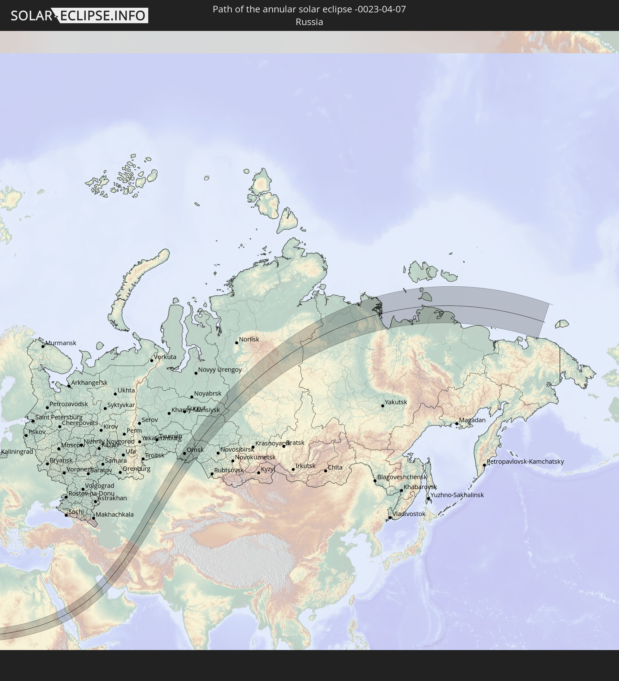 Russia
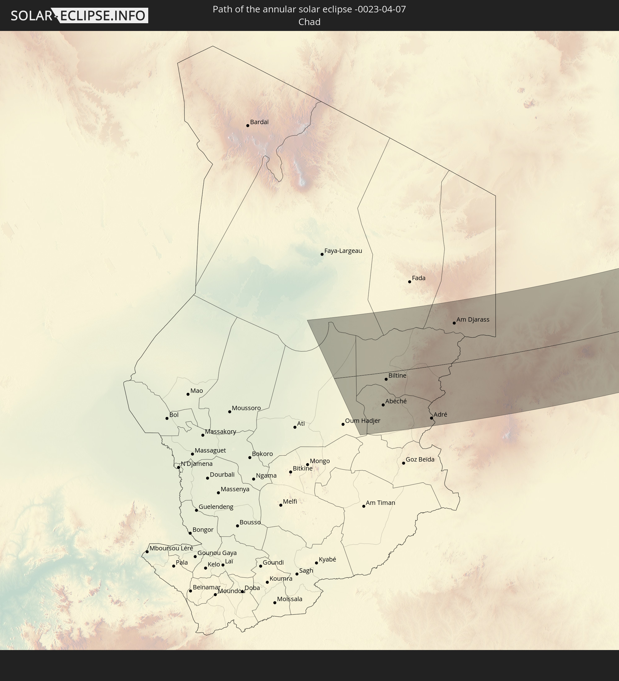 Chad
Chad
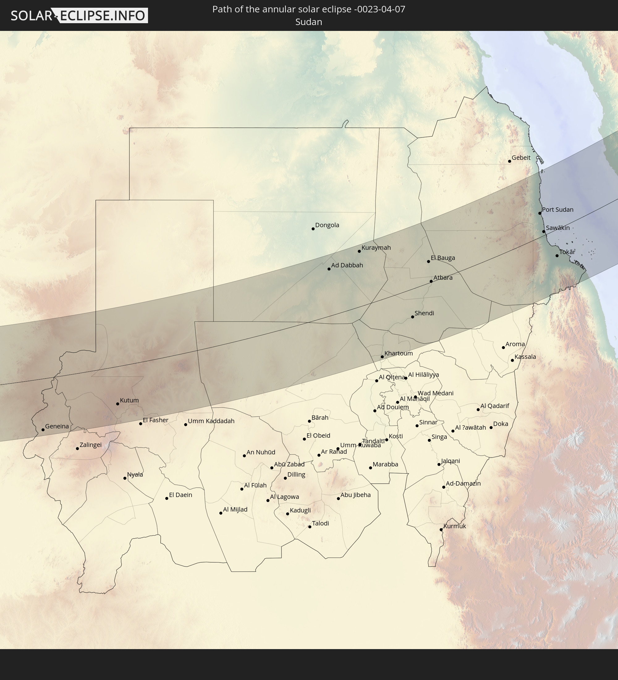 Sudan
Sudan
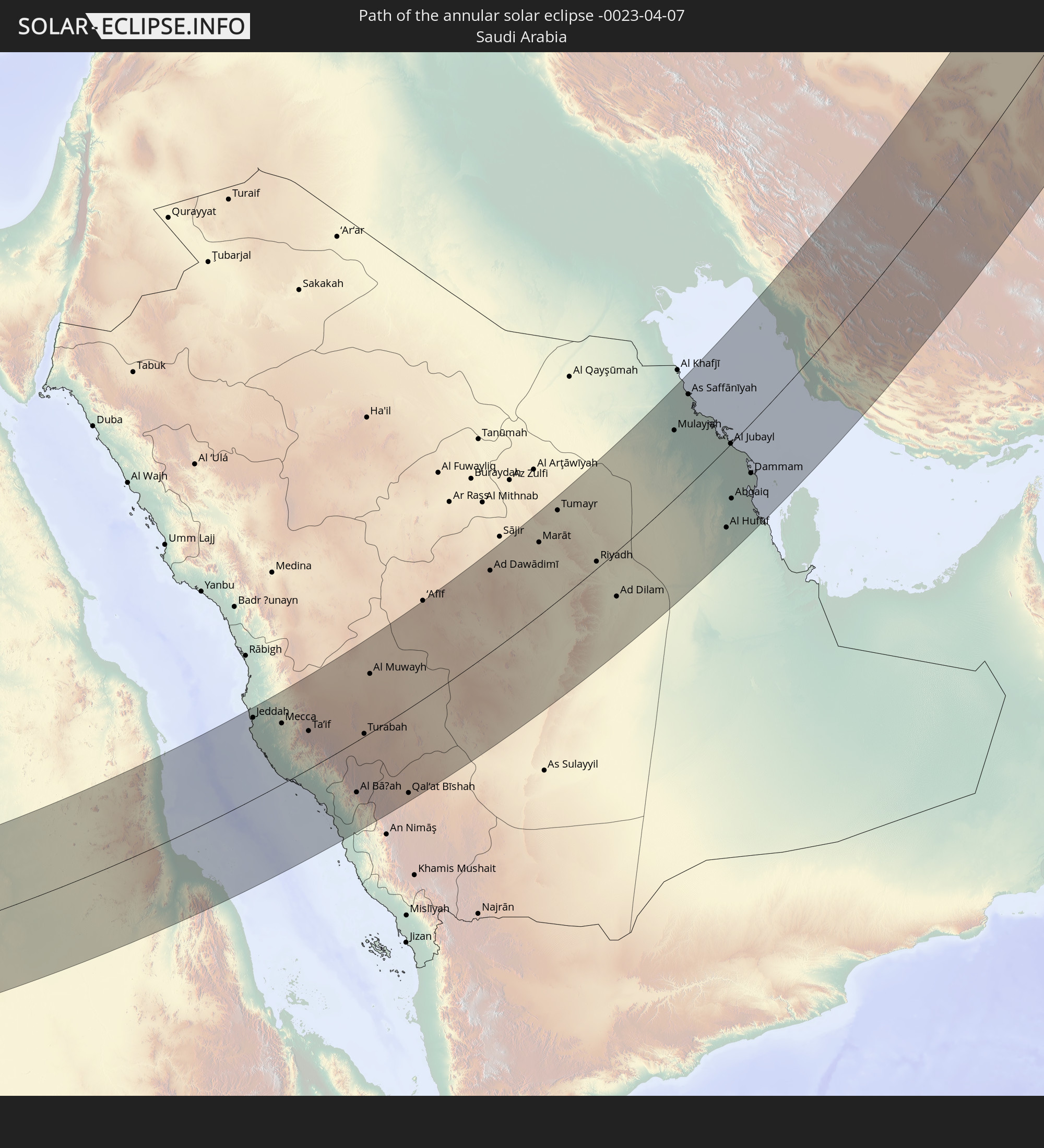 Saudi Arabia
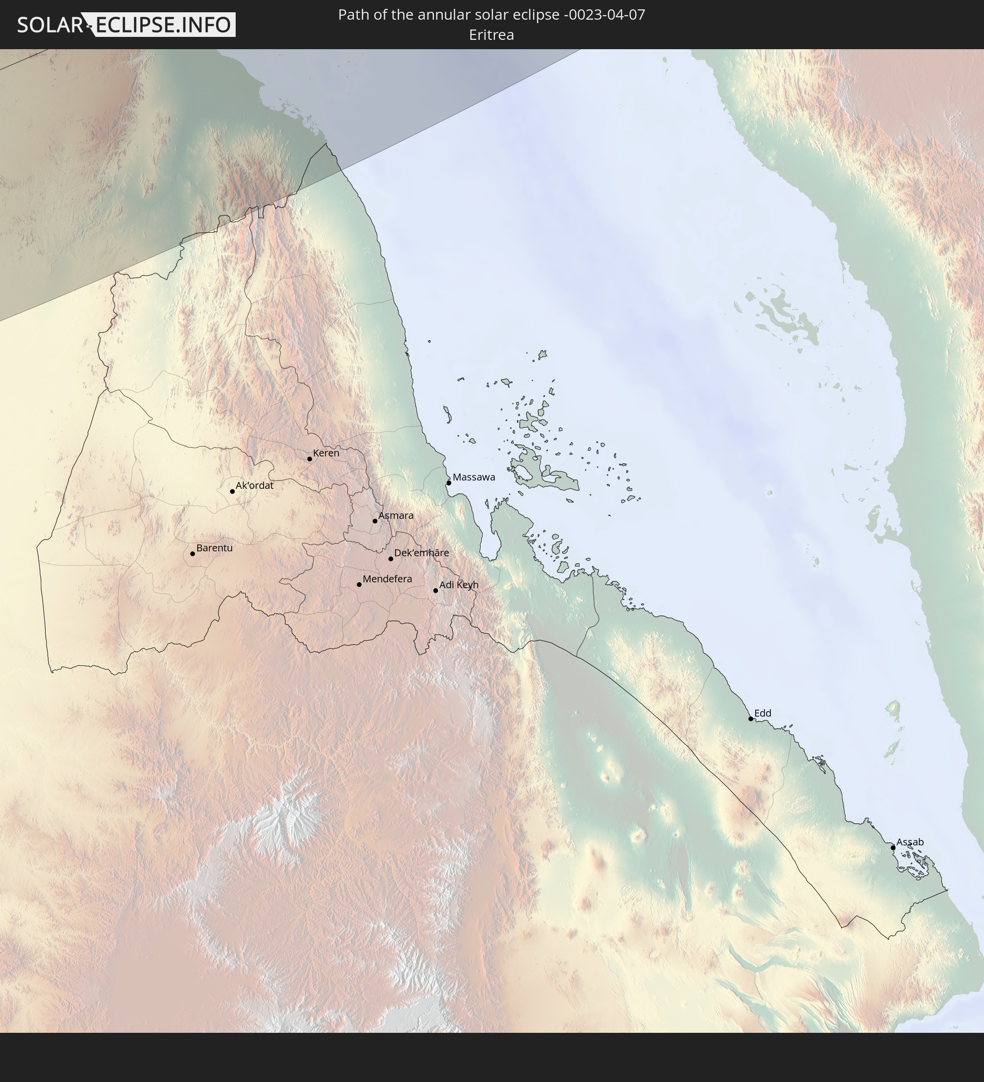 Eritrea
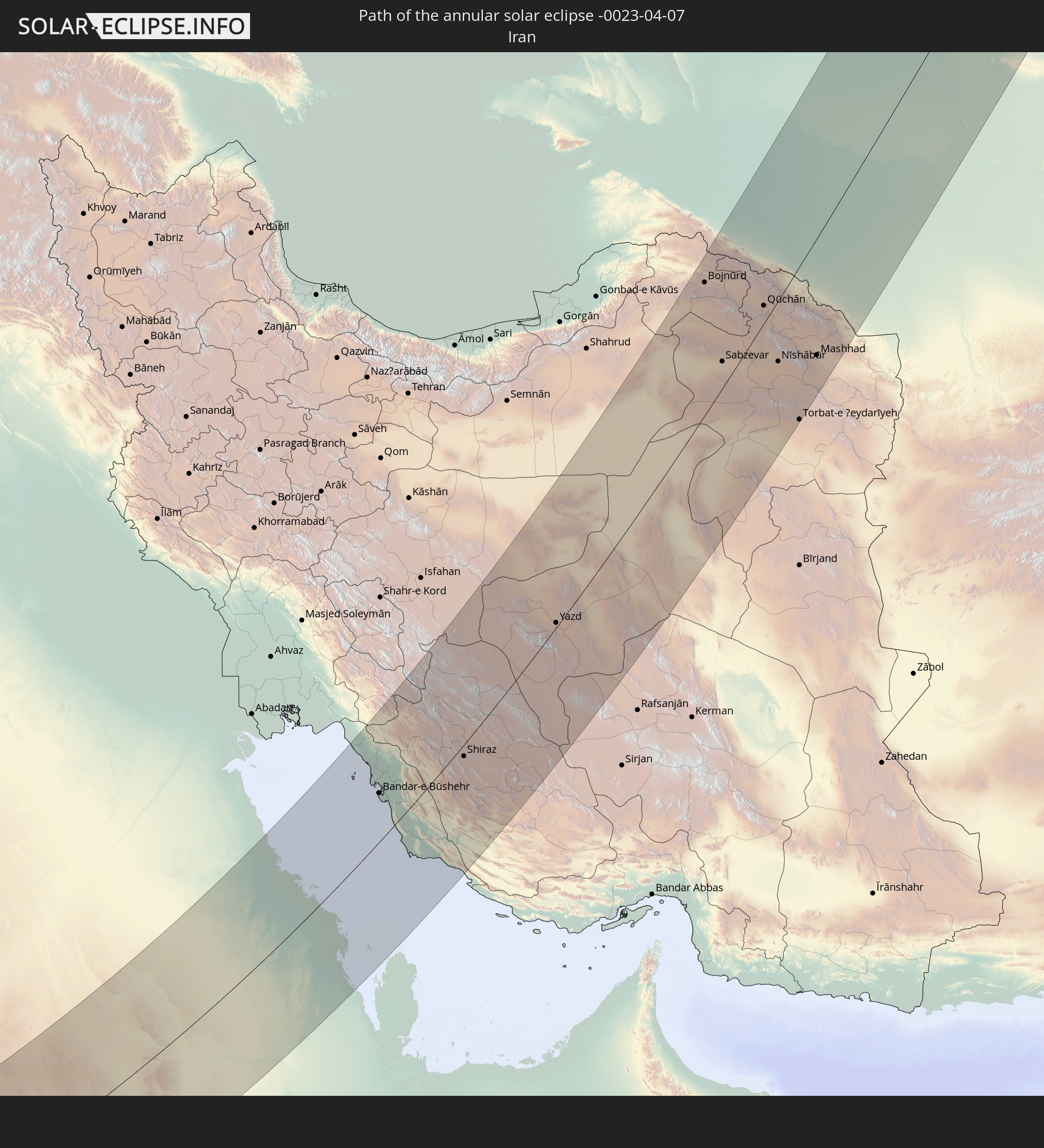 Iran
Iran
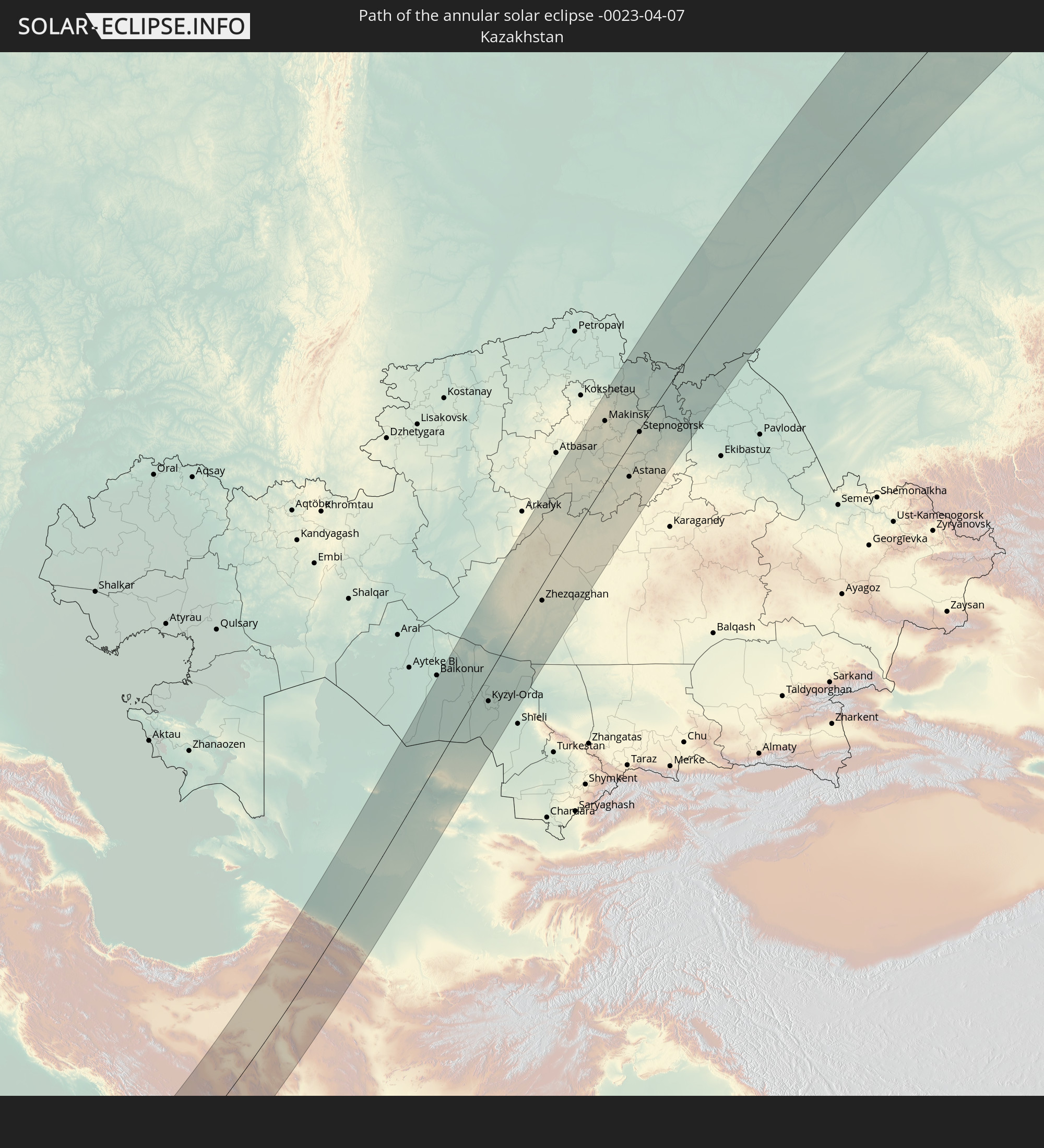 Kazakhstan
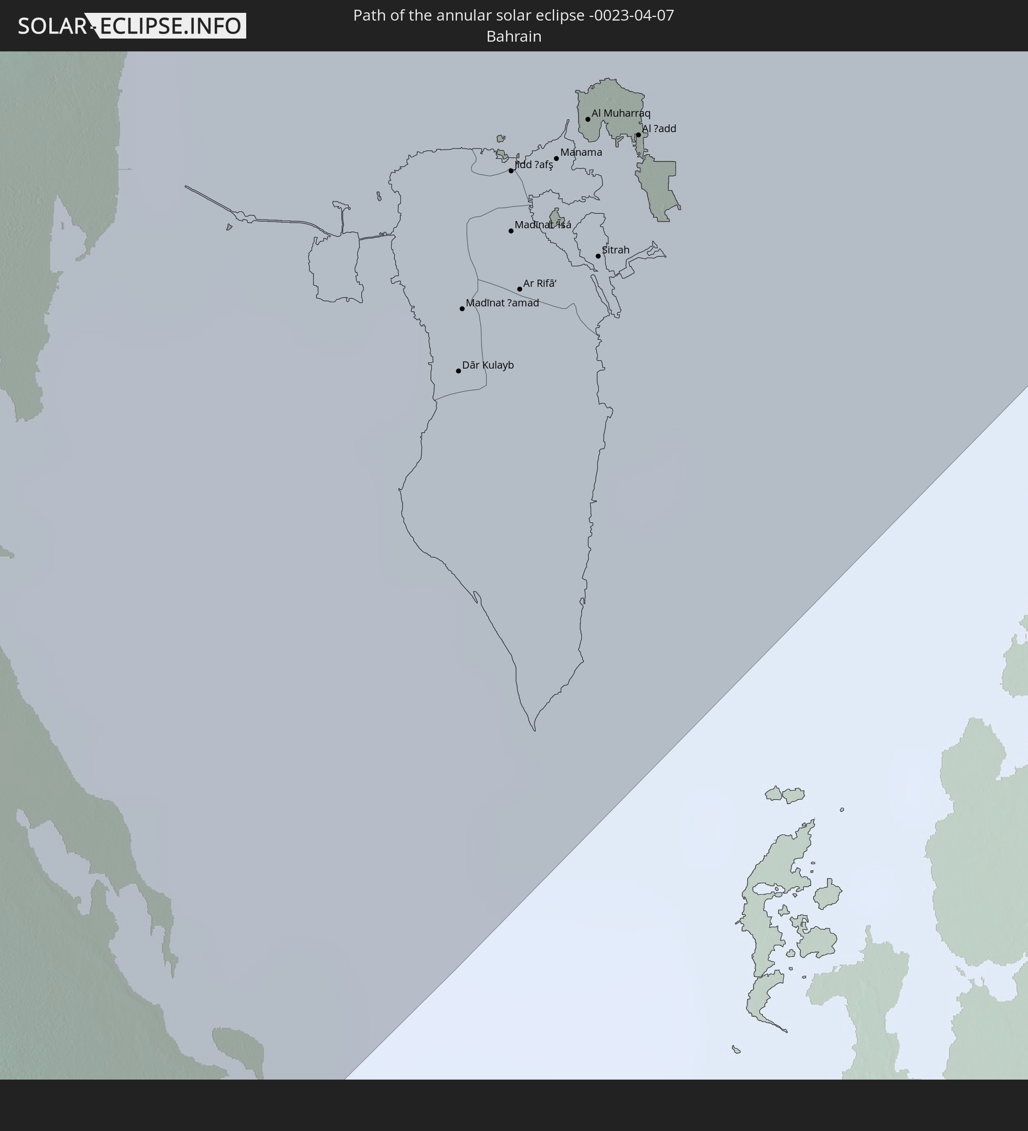 Bahrain
 Turkmenistan
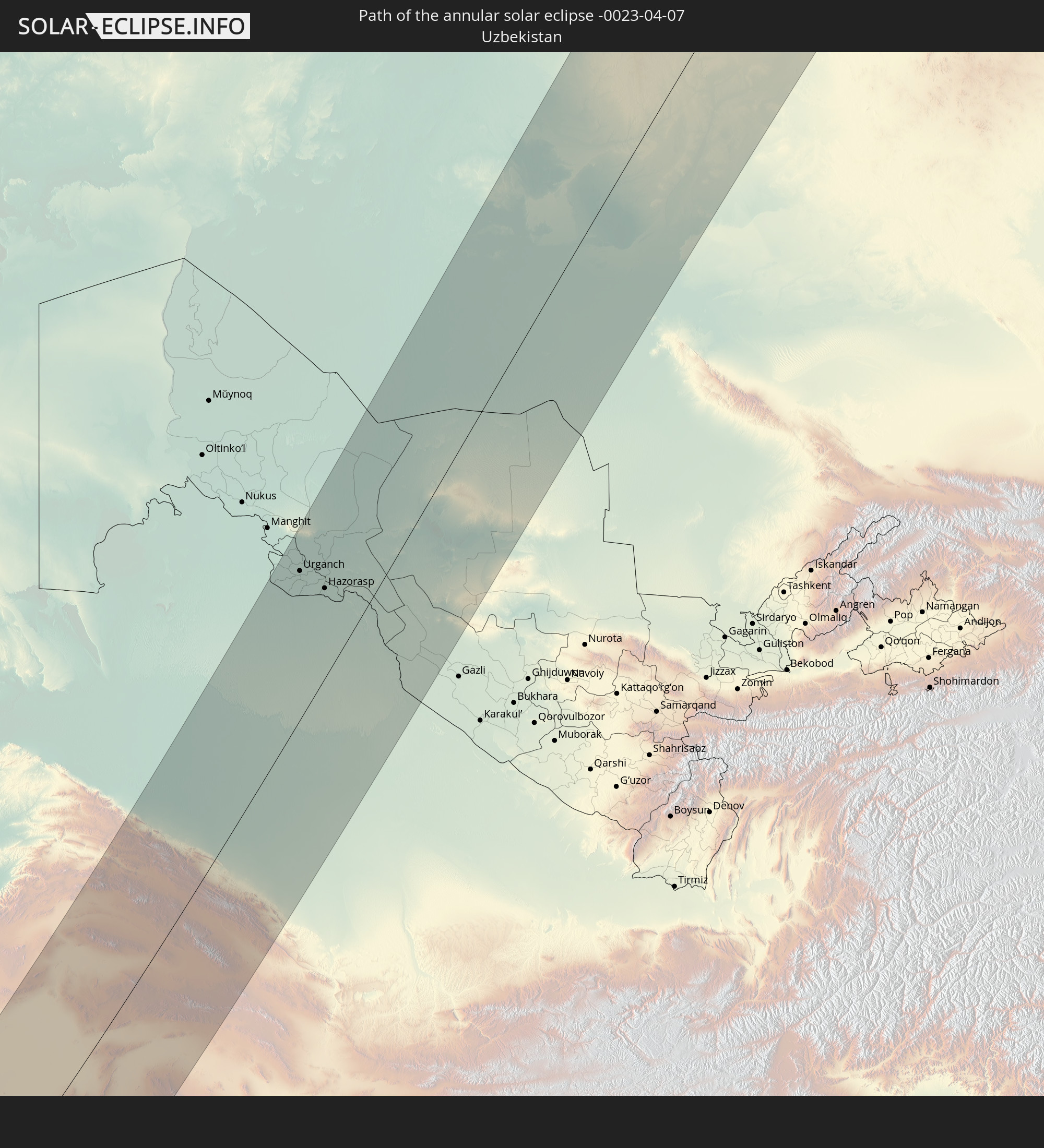 Uzbekistan
In den folgenden Ländern ist die Sonnenfinsternis partiell zu sehen
 Russia
 Canada
 Greenland
 Iceland
 Svalbard and Jan Mayen
 Algeria
 United Kingdom
 Faroe Islands
 France
 Isle of Man
 Belgium
 Netherlands
 Norway
 Luxembourg
 Germany
 Switzerland
 Italy
Italy
 Monaco
 Tunisia
 Denmark
 Libya
Libya
 Liechtenstein
 Austria
 Sweden
 Czechia
 Democratic Republic of the Congo
 San Marino
 Vatican City
 Slovenia
 Chad
Chad
 Croatia
 Poland
 Malta
Malta
 Central African Republic
 Bosnia and Herzegovina
 Hungary
 Slovakia
 Montenegro
 Serbia
 Albania
 Åland Islands
 Greece
 Romania
 Republic of Macedonia
 Finland
 Lithuania
 Latvia
 Estonia
 Sudan
Sudan
 Zambia
 Ukraine
 Bulgaria
 Belarus
 Egypt
Egypt
 Zimbabwe
 Turkey
 Moldova
 Rwanda
 Burundi
 Tanzania
 Uganda
 Mozambique
 Cyprus
 Malawi
 Ethiopia
 Kenya
Kenya
 State of Palestine
 Israel
 Saudi Arabia
 Jordan
 Lebanon
 Syria
Syria
 Eritrea
 Iraq
Iraq
 Georgia
 French Southern and Antarctic Lands
 Somalia
 Djibouti
 Yemen
Yemen
 Madagascar
 Comoros
 Armenia
 Iran
Iran
 Azerbaijan
 Mayotte
 Seychelles
 Kazakhstan
 Kuwait
 Bahrain
 Qatar
Qatar
 United Arab Emirates
 Oman
Oman
 Turkmenistan
 Uzbekistan
 Mauritius
 Afghanistan
 Pakistan
 Tajikistan
 India
India
 Kyrgyzstan
 British Indian Ocean Territory
 Maldives
 China
China
 Sri Lanka
 Nepal
Nepal
 Mongolia
 Bangladesh
 Bhutan
 Myanmar
 Japan
Japan
 North Korea
 South Korea
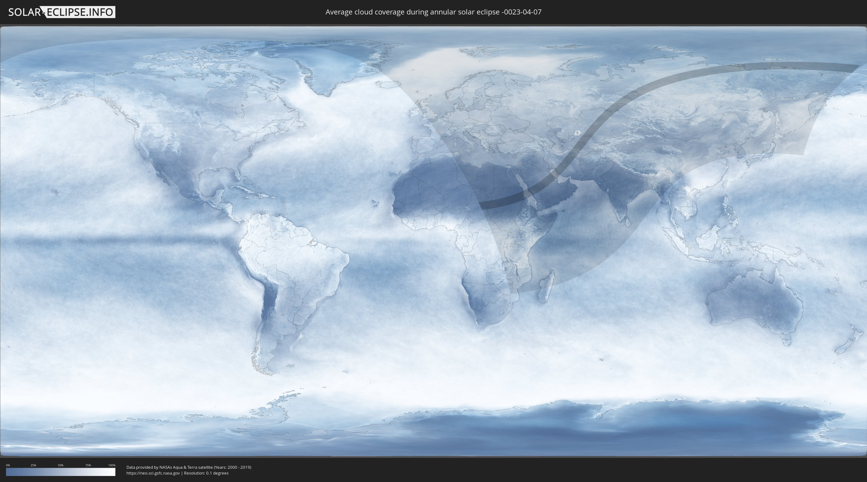
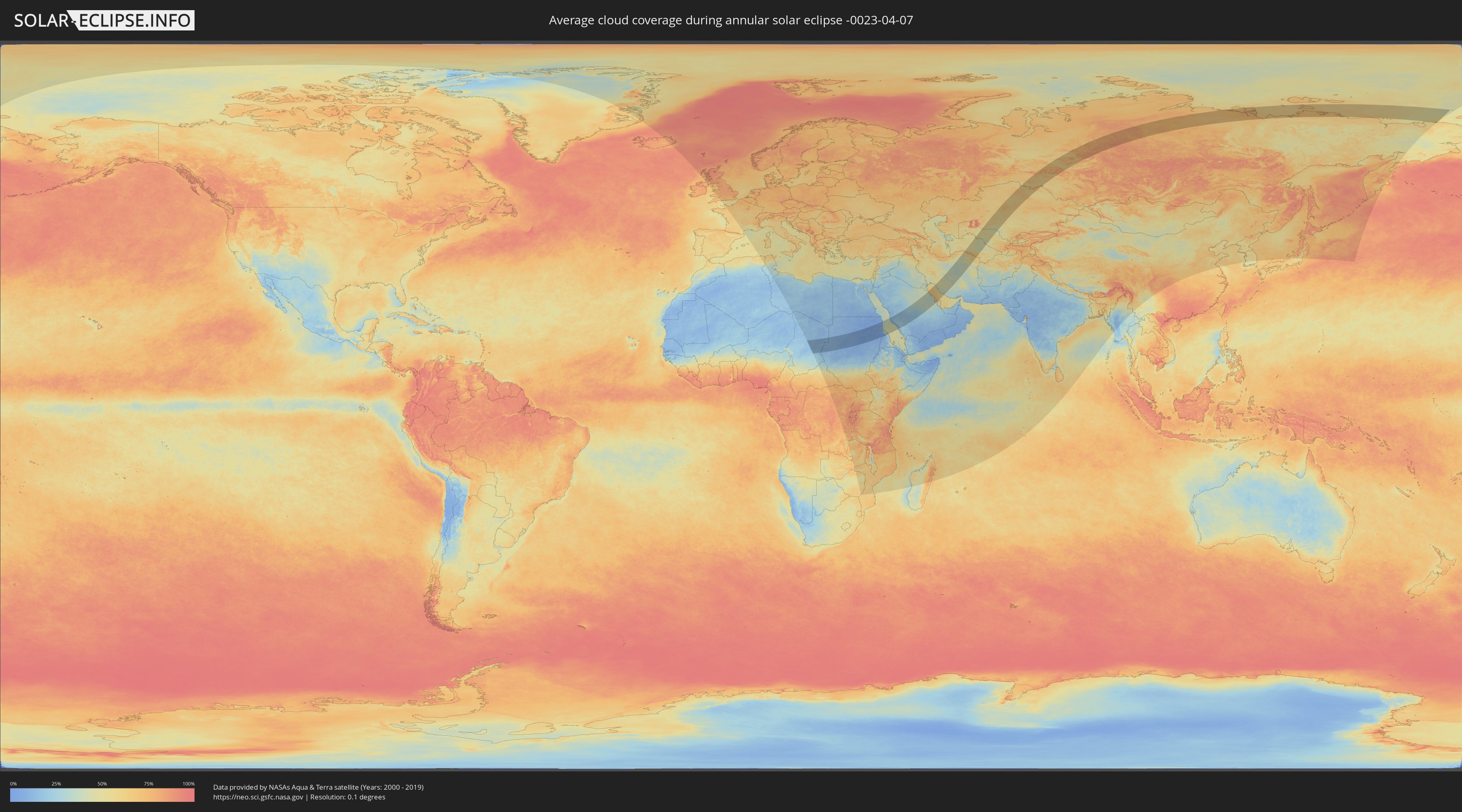
How will be the weather during the annular solar eclipse on 04/07/-0023?
Where is the best place to see the annular solar eclipse of 04/07/-0023?
The following maps show the average cloud coverage for the day of the annular solar eclipse.
With the help of these maps, it is possible to find the place along the eclipse path, which has the best
chance of a cloudless sky.
Nevertheless, you should consider local circumstances and inform about the weather of your chosen
observation site.
The data is provided by NASAs satellites
AQUA and TERRA.
The cloud maps are averaged over a period of 19 years (2000 - 2019).
Detailed country maps
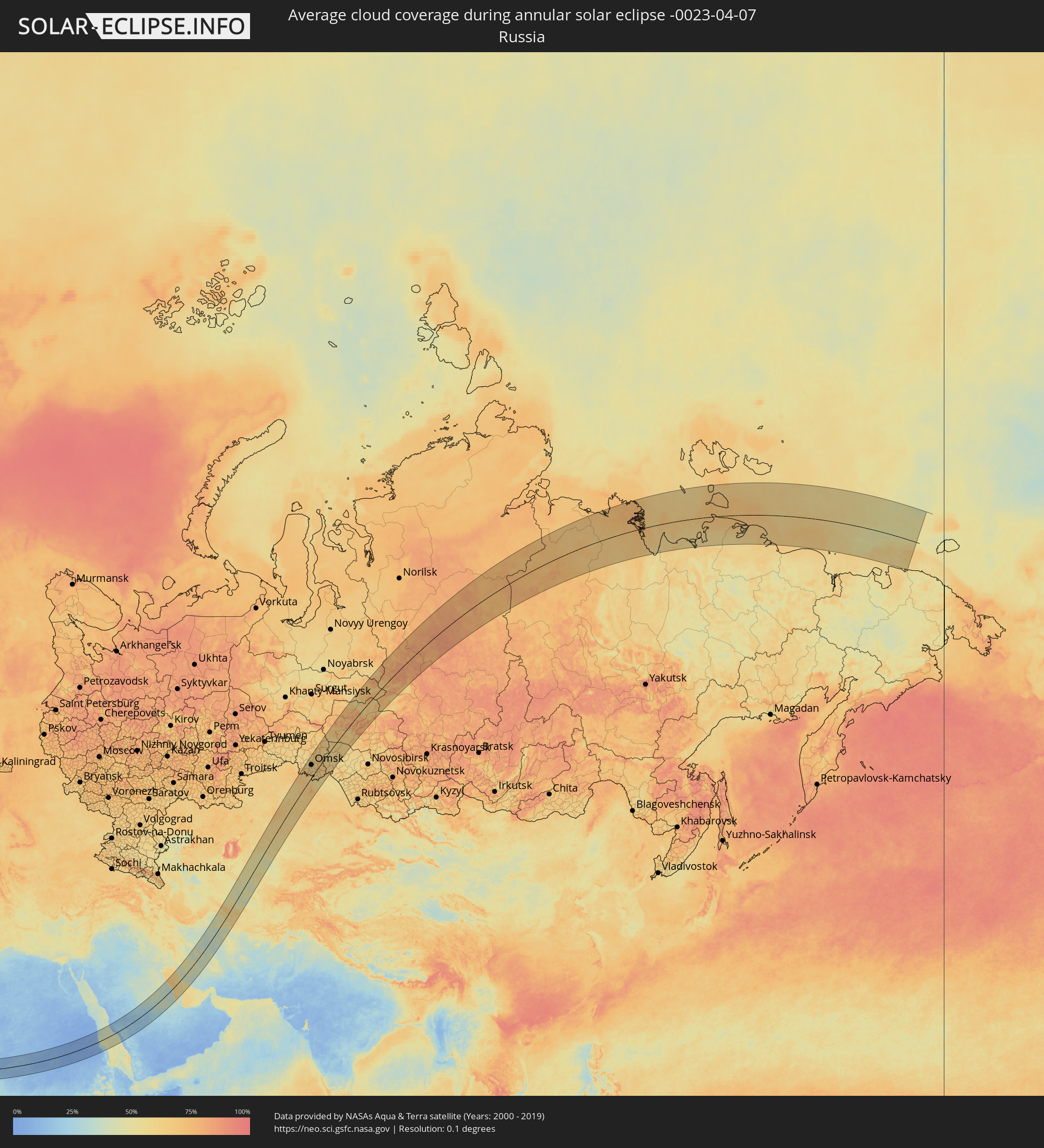 Russia
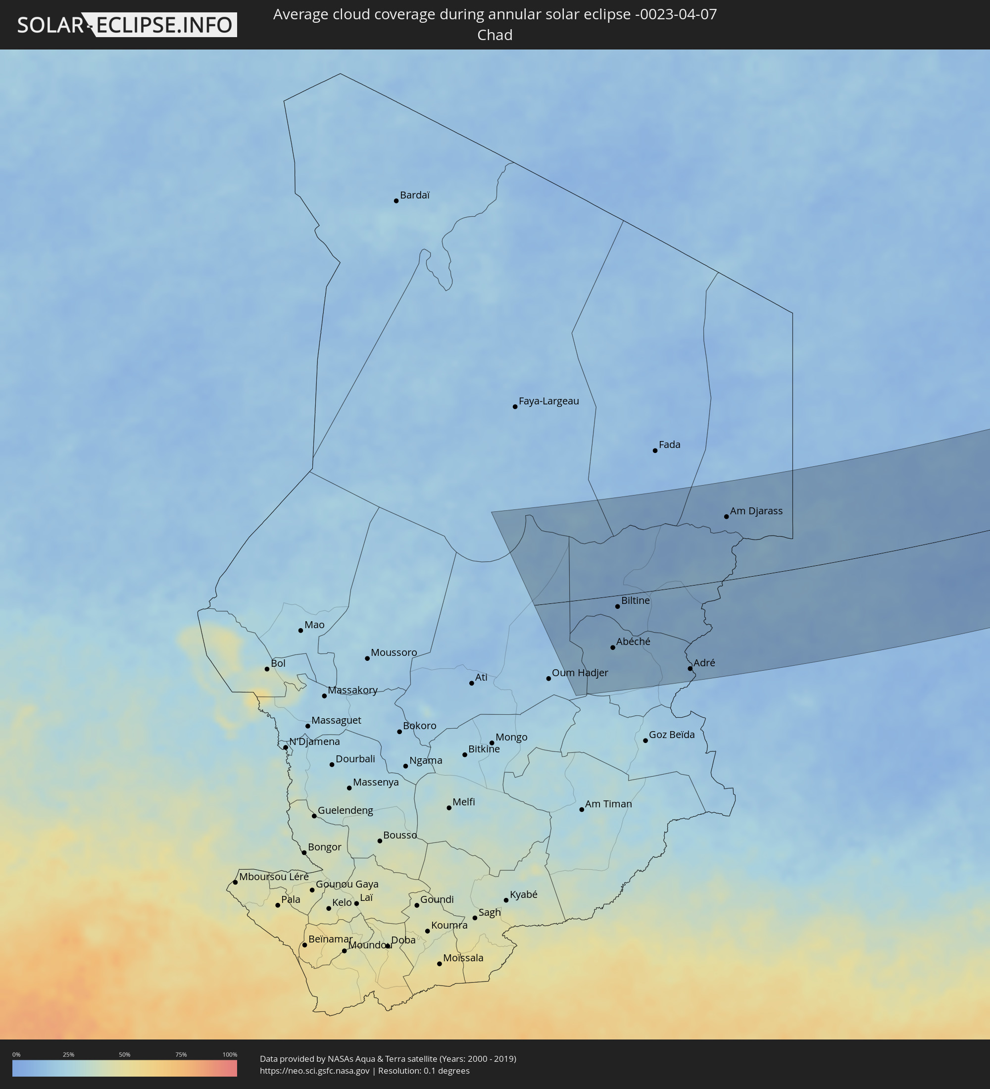 Chad
Chad
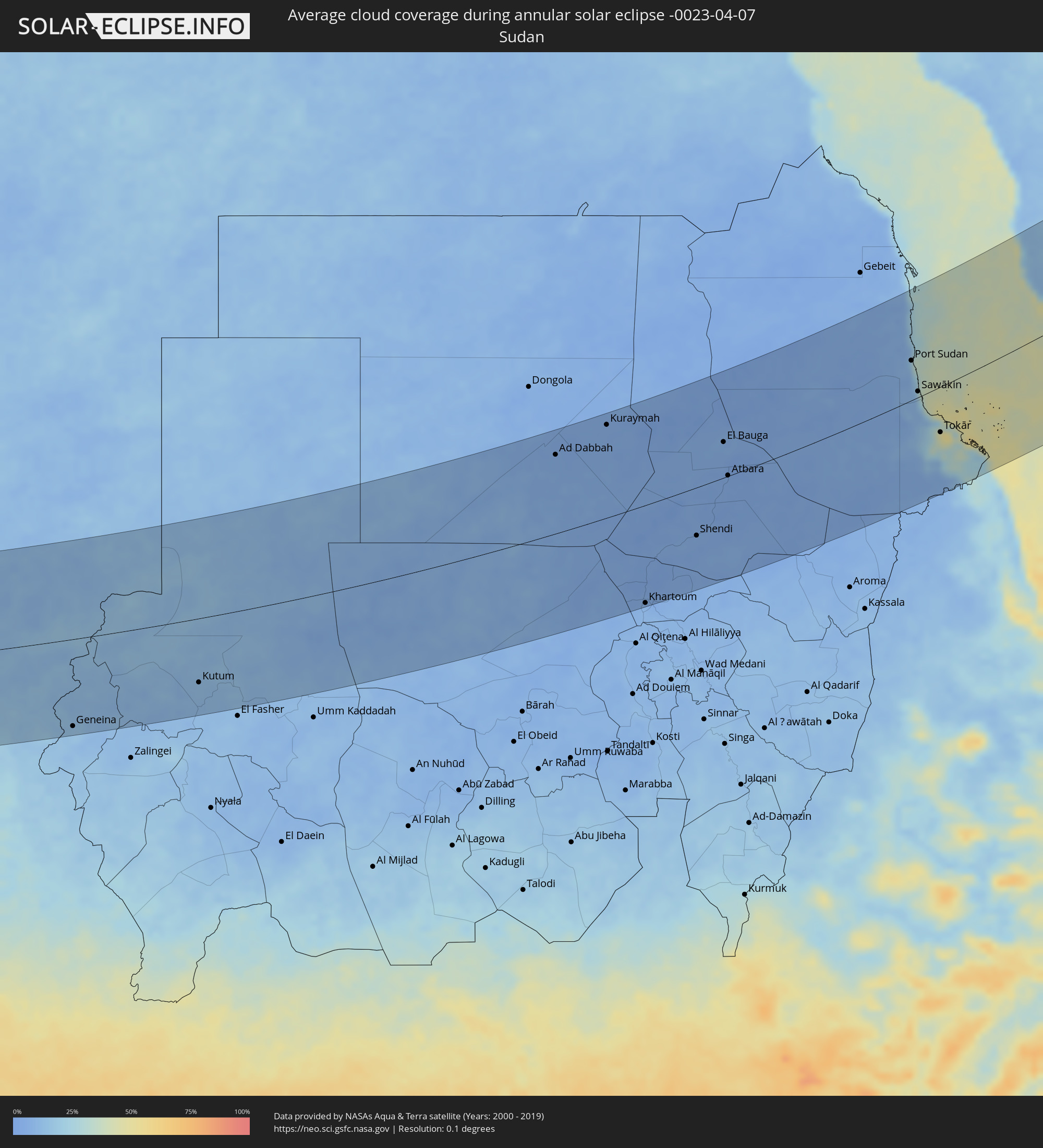 Sudan
Sudan
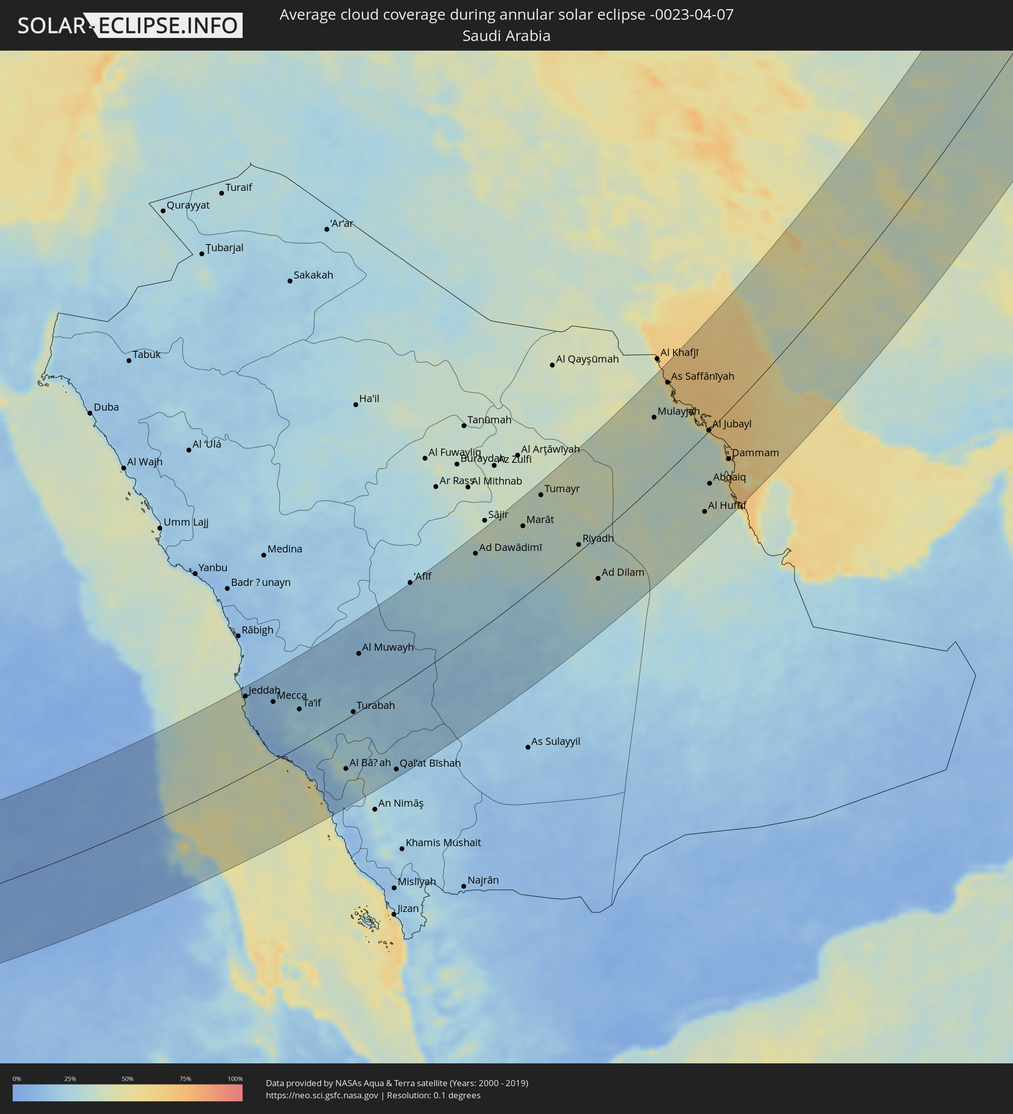 Saudi Arabia
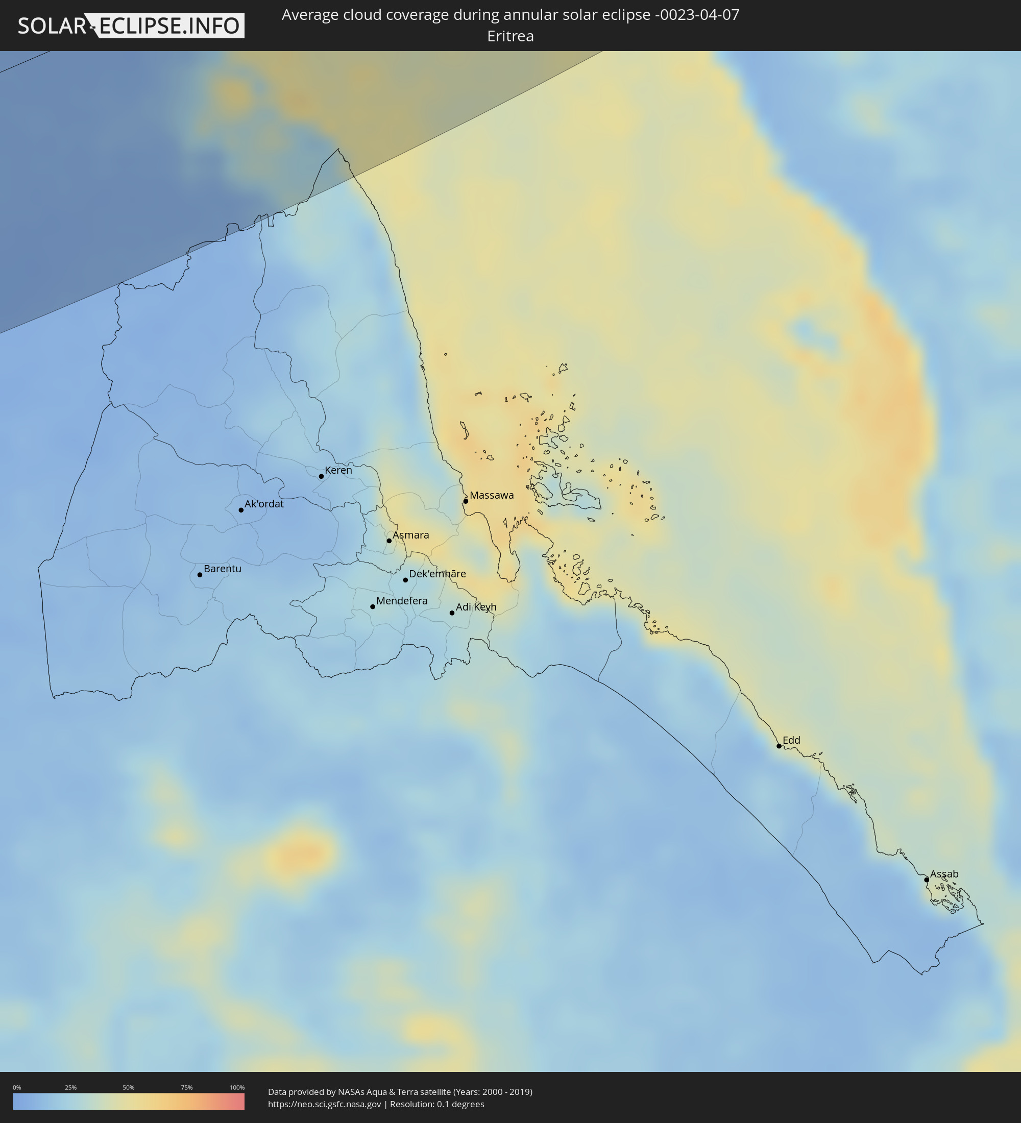 Eritrea
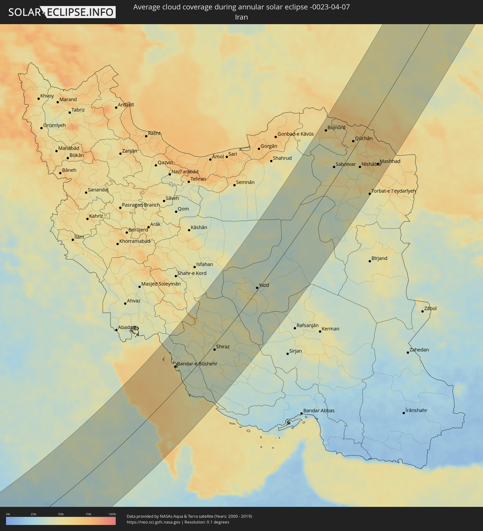 Iran
Iran
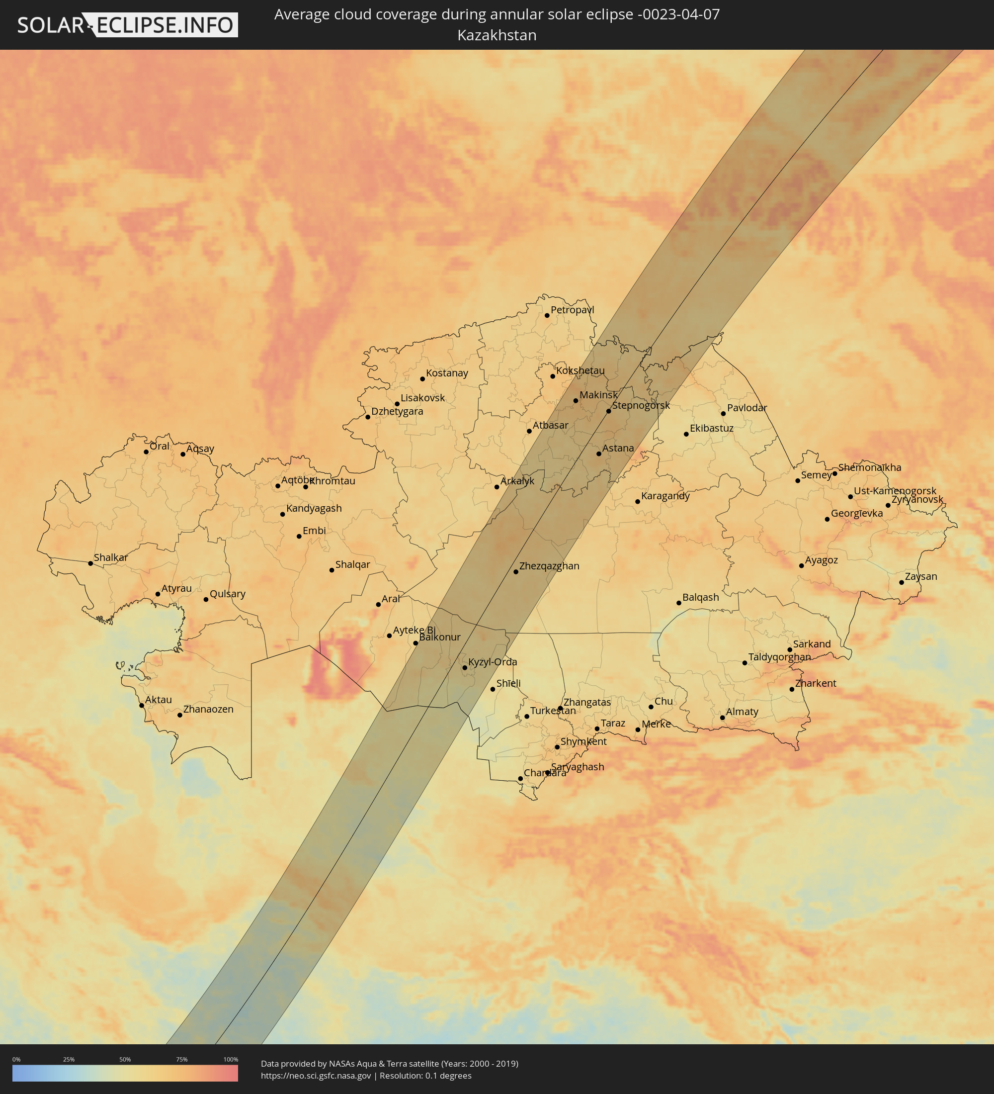 Kazakhstan
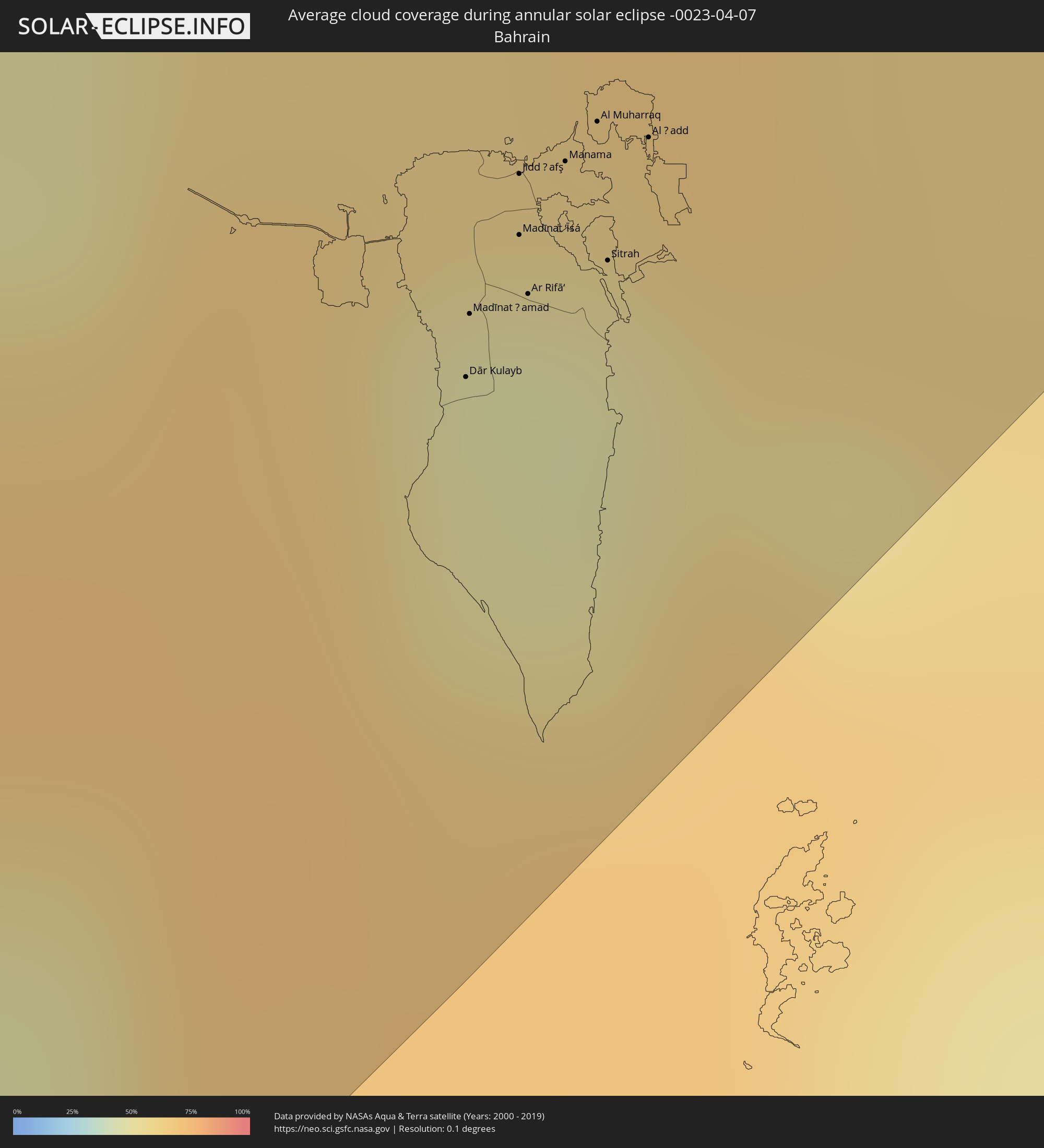 Bahrain
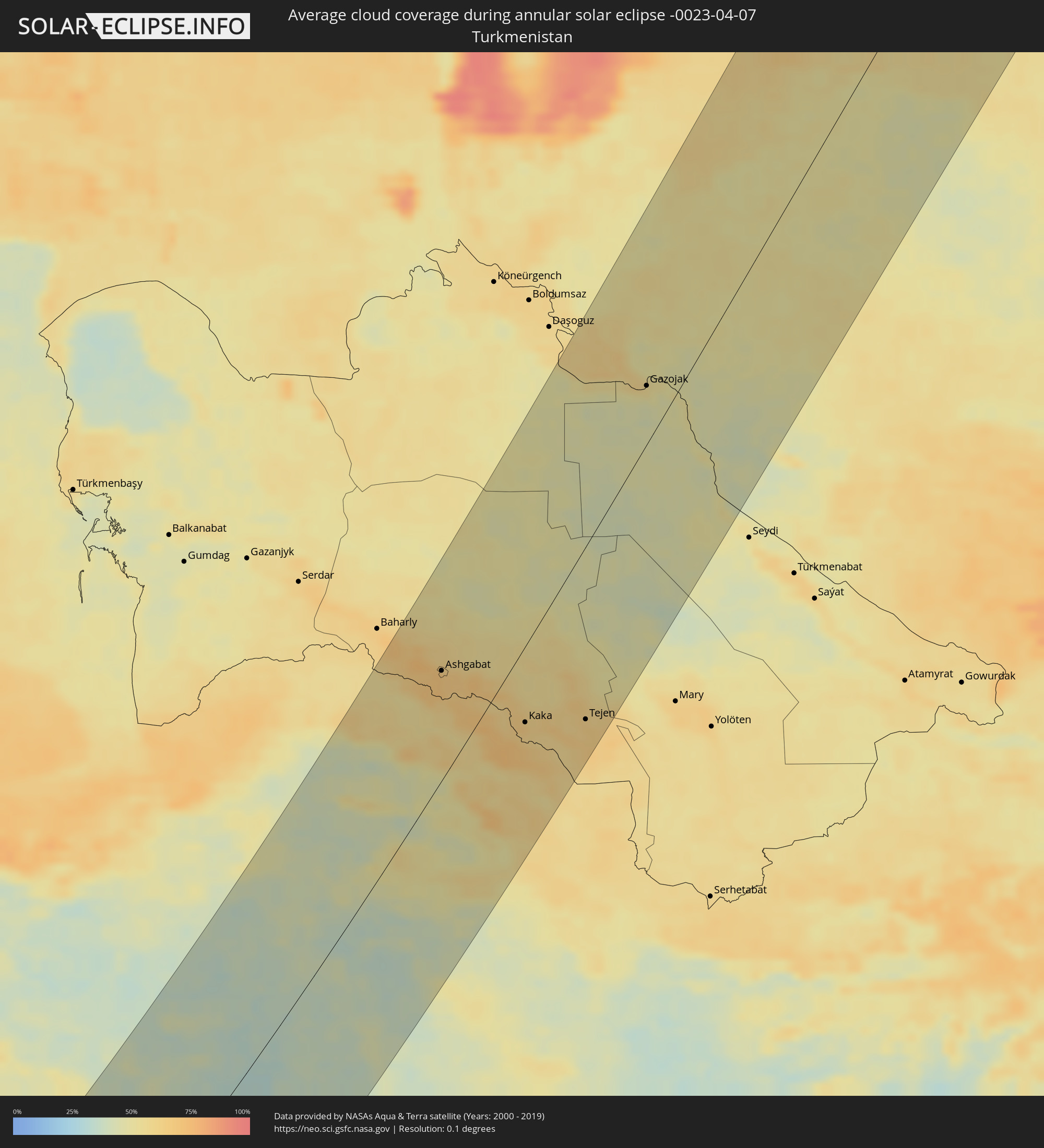 Turkmenistan
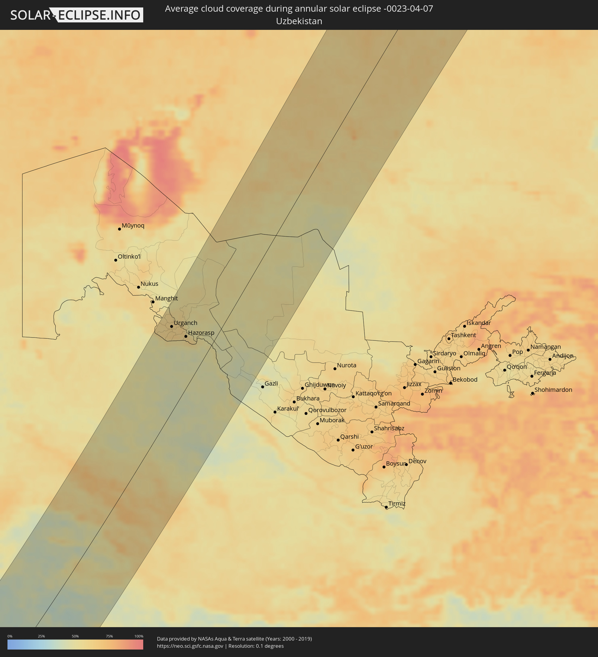 Uzbekistan
Cities inside the path of the eclipse
The following table shows all locations with a population of more than 5,000 inside the eclipse path. Cities which have more than 100,000 inhabitants are marked bold. A click at the locations opens a detailed map.
| City | Type | Eclipse duration | Local time of max. eclipse | Distance to central line | Ø Cloud coverage |
|
Abéché, Ouadaï
|
annular | - | 05:37:17 UTC+01:00 | 99 km | 15% |
|
Biltine, Wadi Fira
|
annular | - | 05:38:16 UTC+01:00 | 22 km | 13% |
|
Adré, Ouadaï
|
annular | - | 05:36:38 UTC+01:00 | 158 km | 13% |
|
Geneina, Western Darfur
|
annular | - | 06:46:32 UTC+02:10 | 163 km | 14% |
|
Am Djarass, Ennedi-Est
|
annular | - | 05:40:23 UTC+01:00 | 118 km | 10% |
|
Kutum, Northern Darfur
|
annular | - | 06:47:30 UTC+02:10 | 119 km | 12% |
|
Ad Dabbah, Northern State
|
annular | - | 06:54:20 UTC+02:10 | 141 km | 5% |
|
Marawī, Northern State
|
annular | - | 06:55:18 UTC+02:10 | 159 km | 5% |
|
Kuraymah, Northern State
|
annular | - | 06:55:26 UTC+02:10 | 165 km | 5% |
|
Omdurman, Khartoum
|
annular | - | 06:50:38 UTC+02:10 | 163 km | 8% |
|
Khartoum, Khartoum
|
annular | - | 06:50:29 UTC+02:10 | 175 km | 8% |
|
El Matama, River Nile
|
annular | - | 06:52:39 UTC+02:10 | 80 km | 6% |
|
Shendi, River Nile
|
annular | - | 06:52:39 UTC+02:10 | 85 km | 6% |
|
El Bauga, River Nile
|
annular | - | 06:55:32 UTC+02:10 | 62 km | 6% |
|
Ed Damer, River Nile
|
annular | - | 06:54:23 UTC+02:10 | 9 km | 4% |
|
Berber, River Nile
|
annular | - | 06:55:08 UTC+02:10 | 35 km | 3% |
|
Atbara, River Nile
|
annular | - | 06:54:34 UTC+02:10 | 1 km | 4% |
|
Port Sudan, Red Sea
|
annular | - | 06:59:18 UTC+02:10 | 67 km | 11% |
|
Sawākin, Red Sea
|
annular | - | 06:58:24 UTC+02:10 | 10 km | 11% |
|
Tokār, Red Sea
|
annular | - | 06:57:18 UTC+02:10 | 76 km | 40% |
|
Jeddah, Makkah
|
annular | - | 08:00:44 UTC+03:06 | 164 km | 25% |
|
Al Jumūm, Makkah
|
annular | - | 08:01:10 UTC+03:06 | 146 km | 15% |
|
Mecca, Makkah
|
annular | - | 08:00:52 UTC+03:06 | 121 km | 16% |
|
Ash Shafā, Makkah
|
annular | - | 08:00:26 UTC+03:06 | 61 km | 26% |
|
Ta’if, Makkah
|
annular | - | 08:00:53 UTC+03:06 | 75 km | 23% |
|
Al Bāḩah, Al Bahah
|
annular | - | 07:59:01 UTC+03:06 | 101 km | 32% |
|
Turabah, Makkah
|
annular | - | 08:01:30 UTC+03:06 | 5 km | 22% |
|
Qal‘at Bīshah, 'Asir
|
annular | - | 07:59:40 UTC+03:06 | 163 km | 18% |
|
‘Afīf, Ar Riyāḑ
|
annular | - | 08:07:53 UTC+03:06 | 182 km | 22% |
|
Ad Dawādimī, Ar Riyāḑ
|
annular | - | 08:10:14 UTC+03:06 | 145 km | 29% |
|
Riyadh, Ar Riyāḑ
|
annular | - | 08:12:28 UTC+03:06 | 12 km | 37% |
|
Ad Dilam, Ar Riyāḑ
|
annular | - | 08:11:19 UTC+03:06 | 76 km | 34% |
|
Al Hufūf, Eastern Province
|
annular | - | 08:16:27 UTC+03:06 | 124 km | 39% |
|
Al Qurayn, Eastern Province
|
annular | - | 08:16:45 UTC+03:06 | 117 km | 42% |
|
Al Baţţālīyah, Eastern Province
|
annular | - | 08:16:40 UTC+03:06 | 123 km | 39% |
|
Al Jubayl, Eastern Province
|
annular | - | 08:20:15 UTC+03:06 | 0 km | 47% |
|
Al Munayzilah, Eastern Province
|
annular | - | 08:16:35 UTC+03:06 | 130 km | 40% |
|
Abqaiq, Eastern Province
|
annular | - | 08:17:50 UTC+03:06 | 86 km | 34% |
|
Aţ Ţaraf, Eastern Province
|
annular | - | 08:16:36 UTC+03:06 | 135 km | 40% |
|
Tārūt, Eastern Province
|
annular | - | 08:19:37 UTC+03:06 | 61 km | 46% |
|
Raḩīmah, Eastern Province
|
annular | - | 08:19:57 UTC+03:06 | 52 km | 62% |
|
Dammam, Eastern Province
|
annular | - | 08:19:22 UTC+03:06 | 76 km | 39% |
|
Khobar, Eastern Province
|
annular | - | 08:19:07 UTC+03:06 | 96 km | 50% |
|
Dār Kulayb, Southern Governorate
|
annular | - | 08:38:11 UTC+03:26 | 133 km | 48% |
|
Madīnat Ḩamad, Central Governorate
|
annular | - | 08:38:18 UTC+03:26 | 130 km | 48% |
|
Bandar-e Ganāveh, Bushehr
|
annular | - | 08:45:49 UTC+03:25 | 132 km | 52% |
|
Madīnat ‘Īsá, Southern Governorate
|
annular | - | 08:38:28 UTC+03:26 | 128 km | 47% |
|
Jidd Ḩafş, Manama
|
annular | - | 08:38:34 UTC+03:26 | 125 km | 47% |
|
Ar Rifā‘, Southern Governorate
|
annular | - | 08:38:22 UTC+03:26 | 132 km | 47% |
|
Manama, Manama
|
annular | - | 08:38:37 UTC+03:26 | 127 km | 48% |
|
Al Muharraq, Muharraq
|
annular | - | 08:38:43 UTC+03:26 | 126 km | 58% |
|
Sitrah, Manama
|
annular | - | 08:38:29 UTC+03:26 | 135 km | 48% |
|
Al Ḩadd, Muharraq
|
annular | - | 08:38:44 UTC+03:26 | 130 km | 57% |
|
Dogonbadan, Kohgīlūyeh va Būyer Aḩmad
|
annular | - | 08:47:54 UTC+03:25 | 167 km | 43% |
|
Bandar-e Būshehr, Bushehr
|
annular | - | 08:44:44 UTC+03:25 | 64 km | 50% |
|
Borāzjān, Bushehr
|
annular | - | 08:45:49 UTC+03:25 | 58 km | 42% |
|
Nūrābād, Fars
|
annular | - | 08:48:04 UTC+03:25 | 96 km | 46% |
|
Yasuj, Kohgīlūyeh va Būyer Aḩmad
|
annular | - | 08:49:25 UTC+03:25 | 130 km | 52% |
|
Kāzerūn, Fars
|
annular | - | 08:47:04 UTC+03:25 | 51 km | 43% |
|
Shiraz, Fars
|
annular | - | 08:47:57 UTC+03:25 | 14 km | 46% |
|
Fīrūzābād, Fars
|
annular | - | 08:46:13 UTC+03:25 | 73 km | 44% |
|
Ābādeh, Fars
|
annular | - | 08:51:41 UTC+03:25 | 85 km | 40% |
|
Akbarābād, Fars
|
annular | - | 08:47:22 UTC+03:25 | 59 km | 42% |
|
Fasā, Fars
|
annular | - | 08:47:35 UTC+03:25 | 146 km | 38% |
|
Ardakān, Yazd
|
annular | - | 08:55:52 UTC+03:25 | 59 km | 41% |
|
Yazd, Yazd
|
annular | - | 08:55:18 UTC+03:25 | 5 km | 39% |
|
Bojnūrd, Khorāsān-e Shomālī
|
annular | - | 09:11:46 UTC+03:25 | 127 km | 57% |
|
Esfarāyen, Khorāsān-e Shomālī
|
annular | - | 09:11:04 UTC+03:25 | 90 km | 46% |
|
Sabzevar, Razavi Khorasan
|
annular | - | 09:09:17 UTC+03:25 | 26 km | 44% |
|
Shīrvān, Khorāsān-e Shomālī
|
annular | - | 09:12:19 UTC+03:25 | 77 km | 56% |
|
Abadan, Ahal
|
annular | - | 09:41:57 UTC+03:53 | 96 km | 70% |
|
Ashgabat, Ahal
|
annular | - | 09:41:57 UTC+03:53 | 76 km | 66% |
|
Kāshmar, Razavi Khorasan
|
annular | - | 09:07:58 UTC+03:25 | 93 km | 45% |
|
Qūchān, Razavi Khorasan
|
annular | - | 09:12:22 UTC+03:25 | 17 km | 61% |
|
Annau, Ahal
|
annular | - | 09:41:58 UTC+03:53 | 62 km | 66% |
|
Nīshābūr, Razavi Khorasan
|
annular | - | 09:10:39 UTC+03:25 | 58 km | 52% |
|
Torbat-e Ḩeydarīyeh, Razavi Khorasan
|
annular | - | 09:08:59 UTC+03:25 | 147 km | 47% |
|
Mashhad, Razavi Khorasan
|
annular | - | 09:11:51 UTC+03:25 | 110 km | 59% |
|
Kaka, Ahal
|
annular | - | 09:42:06 UTC+03:53 | 52 km | 62% |
|
Showot, Xorazm
|
annular | - | 10:27:01 UTC+04:27 | 143 km | 60% |
|
Qŭshkŭpir, Xorazm
|
annular | - | 10:26:48 UTC+04:27 | 133 km | 59% |
|
Khiwa, Xorazm
|
annular | - | 10:26:29 UTC+04:27 | 123 km | 58% |
|
Tejen, Ahal
|
annular | - | 09:43:19 UTC+03:53 | 117 km | 64% |
|
Urganch, Xorazm
|
annular | - | 10:27:12 UTC+04:27 | 113 km | 61% |
|
Beruniy, Karakalpakstan
|
annular | - | 10:27:40 UTC+04:27 | 112 km | 61% |
|
Novyy Turtkul’, Karakalpakstan
|
annular | - | 10:27:41 UTC+04:27 | 85 km | 62% |
|
Hazorasp, Xorazm
|
annular | - | 10:27:15 UTC+04:27 | 68 km | 57% |
|
Gazojak, Lebap
|
annular | - | 09:53:02 UTC+03:53 | 37 km | 53% |
|
Zhosaly, Qyzylorda
|
annular | - | 10:33:54 UTC+04:21 | 88 km | 61% |
|
Dzhalagash, Qyzylorda
|
annular | - | 10:33:50 UTC+04:21 | 25 km | 61% |
|
Terenozek, Qyzylorda
|
annular | - | 10:34:11 UTC+04:21 | 2 km | 58% |
|
Kyzyl-Orda, Qyzylorda
|
annular | - | 10:34:27 UTC+04:21 | 45 km | 57% |
|
Kyzylorda, Qyzylorda
|
annular | - | 10:34:28 UTC+04:21 | 45 km | 61% |
|
Tasböget, Qyzylorda
|
annular | - | 10:34:22 UTC+04:21 | 52 km | 57% |
|
Zhezqazghan, Qaraghandy
|
annular | - | 10:43:07 UTC+04:21 | 26 km | 61% |
|
Astrakhan, Aqmola
|
annular | - | 10:52:14 UTC+04:21 | 67 km | 60% |
|
Shchuchinsk, Aqmola
|
annular | - | 10:54:57 UTC+04:21 | 127 km | 65% |
|
Būrabay, Soltüstik Qazaqstan
|
annular | - | 10:55:19 UTC+04:21 | 129 km | 75% |
|
Makinsk, Aqmola
|
annular | - | 10:54:45 UTC+04:21 | 96 km | 70% |
|
Shortandy, Aqmola
|
annular | - | 10:54:00 UTC+04:21 | 7 km | 63% |
|
Astana, Astana Qalasy
|
annular | - | 10:53:45 UTC+04:21 | 50 km | 72% |
|
Kīevka, Qaraghandy
|
annular | - | 10:52:23 UTC+04:21 | 112 km | 65% |
|
Zholymbet, Aqmola
|
annular | - | 10:54:58 UTC+04:21 | 32 km | 65% |
|
Poltavka, Omsk
|
annular | - | 11:30:35 UTC+04:53 | 125 km | 59% |
|
Stepnogorsk, Aqmola
|
annular | - | 10:56:07 UTC+04:21 | 4 km | 67% |
|
Aksu, Aqmola
|
annular | - | 10:56:22 UTC+04:21 | 3 km | 68% |
|
Zavodskoy, Aqmola
|
annular | - | 10:56:28 UTC+04:21 | 4 km | 66% |
|
Kzyltu, Soltüstik Qazaqstan
|
annular | - | 10:58:36 UTC+04:21 | 49 km | 65% |
|
Sherbakul’, Omsk
|
annular | - | 11:31:43 UTC+04:53 | 107 km | 61% |
|
Lyubinskiy, Omsk
|
annular | - | 11:32:46 UTC+04:53 | 123 km | 67% |
|
Luzino, Omsk
|
annular | - | 11:32:54 UTC+04:53 | 92 km | 62% |
|
Bestobe, Aqmola
|
annular | - | 10:57:51 UTC+04:21 | 64 km | 60% |
|
Yereymentau, Aqmola
|
annular | - | 10:56:33 UTC+04:21 | 119 km | 74% |
|
Vkhodnoy, Omsk
|
annular | - | 11:33:04 UTC+04:53 | 85 km | 68% |
|
Beregovoy, Omsk
|
annular | - | 11:33:25 UTC+04:53 | 96 km | 69% |
|
Krutaya Gorka, Omsk
|
annular | - | 11:33:41 UTC+04:53 | 108 km | 67% |
|
Omsk, Omsk
|
annular | - | 11:33:21 UTC+04:53 | 77 km | 76% |
|
Sargatskoye, Omsk
|
annular | - | 11:34:19 UTC+04:53 | 109 km | 69% |
|
Pavlogradka, Omsk
|
annular | - | 11:32:30 UTC+04:53 | 18 km | 61% |
|
Tavricheskoye, Omsk
|
annular | - | 11:33:07 UTC+04:53 | 37 km | 63% |
|
Russkaya Polyana, Omsk
|
annular | - | 11:32:18 UTC+04:53 | 26 km | 61% |
|
Kormilovka, Omsk
|
annular | - | 11:34:14 UTC+04:53 | 39 km | 64% |
|
Kalachinsk, Omsk
|
annular | - | 11:34:52 UTC+04:53 | 18 km | 66% |
|
Bol’sherech’ye, Omsk
|
annular | - | 11:36:15 UTC+04:53 | 81 km | 66% |
|
Novovarshavka, Omsk
|
annular | - | 11:33:50 UTC+04:53 | 45 km | 65% |
|
Cherlak, Omsk
|
annular | - | 11:33:57 UTC+04:53 | 52 km | 65% |
|
Muromtsevo, Omsk
|
annular | - | 11:37:18 UTC+04:53 | 68 km | 64% |
|
Zhelezinka, Pavlodar
|
annular | - | 11:02:06 UTC+04:21 | 119 km | 70% |
|
Tatarsk, Novosibirsk
|
annular | - | 12:54:41 UTC+06:11 | 45 km | 62% |
|
Vengerovo, Novosibirsk
|
annular | - | 12:56:09 UTC+06:11 | 53 km | 65% |
|
Chany, Novosibirsk
|
annular | - | 12:55:44 UTC+06:11 | 79 km | 60% |
|
Kargasok, Tomsk
|
annular | - | 13:04:18 UTC+06:11 | 16 km | 62% |
|
Parabel’, Tomsk
|
annular | - | 13:04:41 UTC+06:11 | 69 km | 70% |