Total solar eclipse of 05/18/-0081
| Day of week: | Saturday |
| Maximum duration of eclipse: | 04m52s |
| Maximum width of eclipse path: | 253 km |
| Saros cycle: | 75 |
| Coverage: | 100% |
| Magnitude: | 1.0674 |
| Gamma: | 0.4964 |
Wo kann man die Sonnenfinsternis vom 05/18/-0081 sehen?
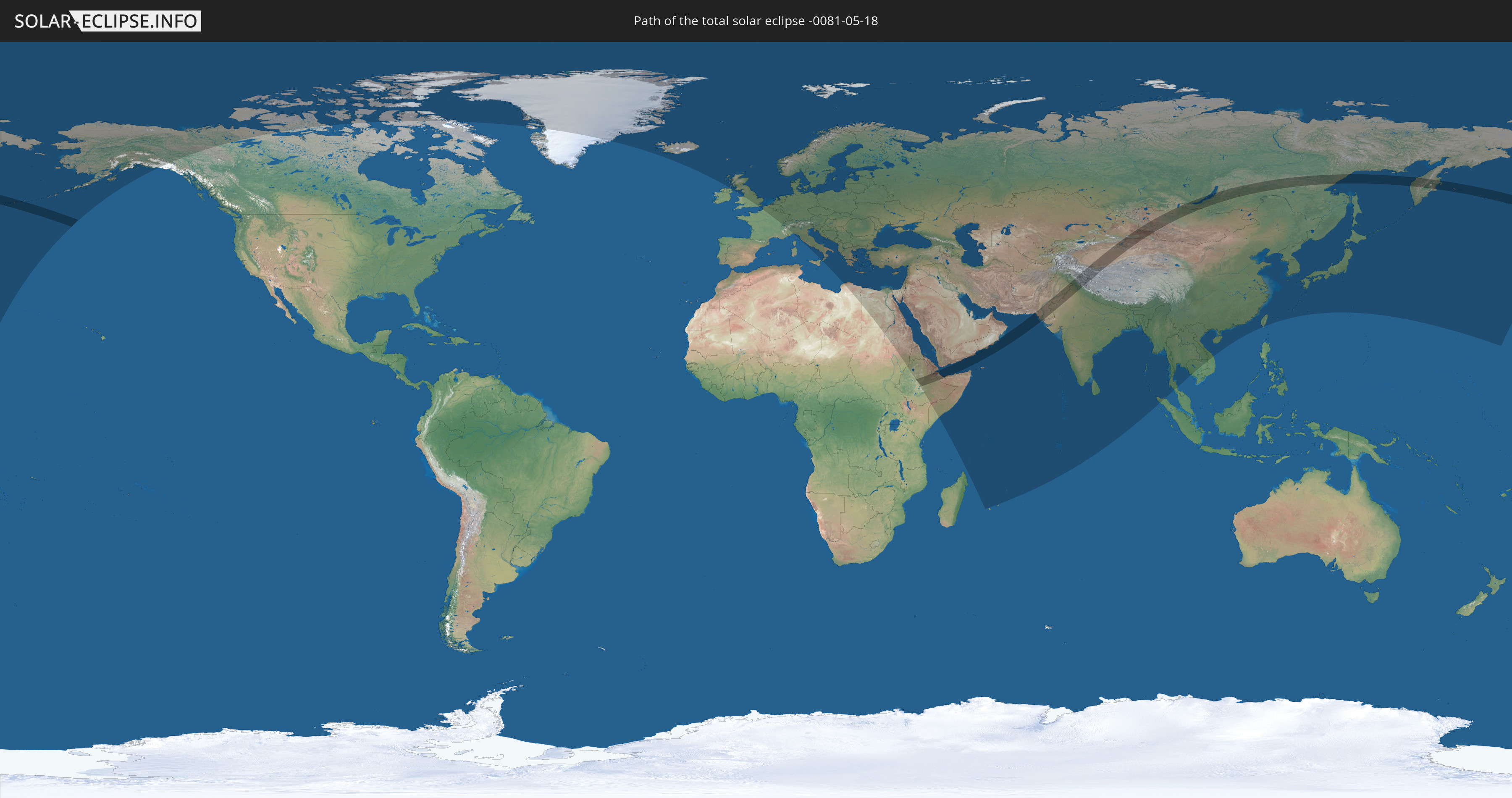
Die Sonnenfinsternis am 05/18/-0081 kann man in 104 Ländern als partielle Sonnenfinsternis beobachten.
Der Finsternispfad verläuft durch 11 Länder. Nur in diesen Ländern ist sie als total Sonnenfinsternis zu sehen.
In den folgenden Ländern ist die Sonnenfinsternis total zu sehen
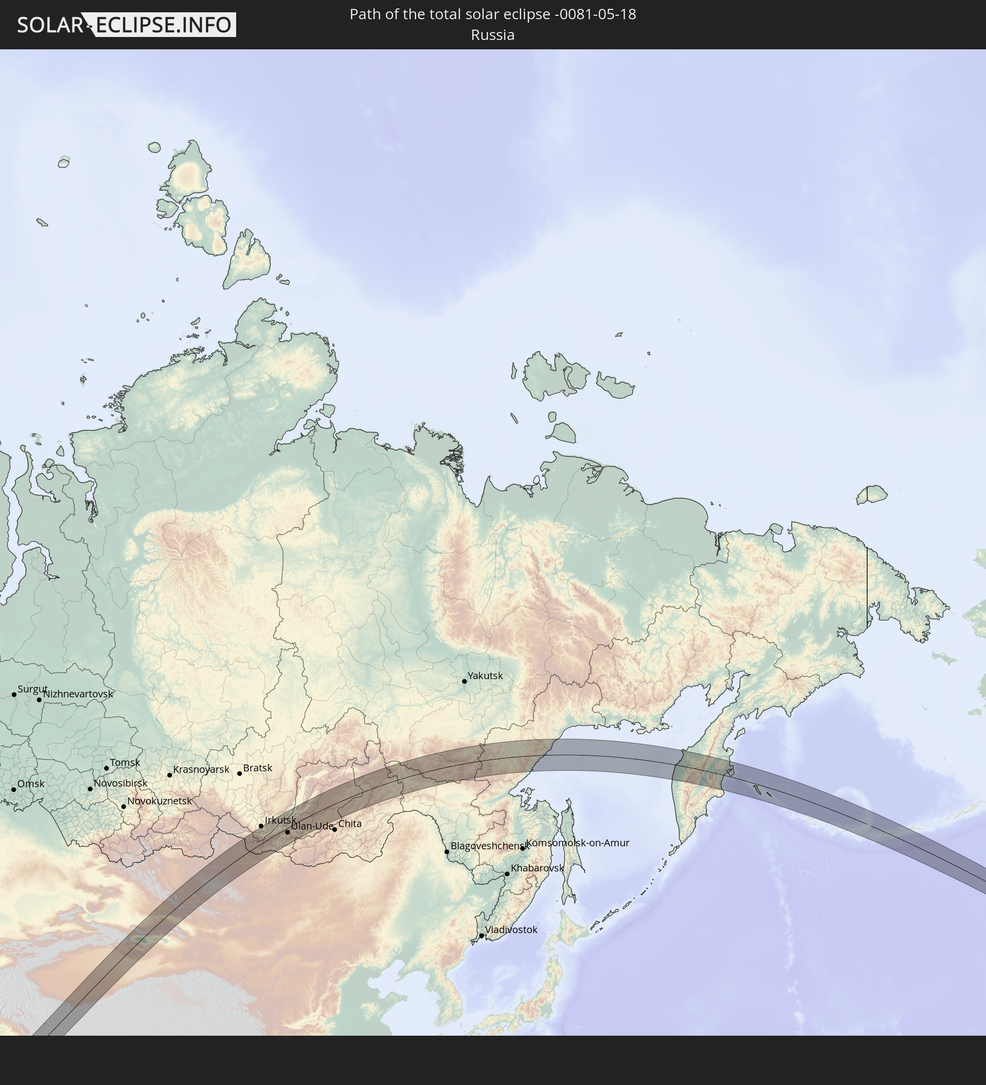 Russia
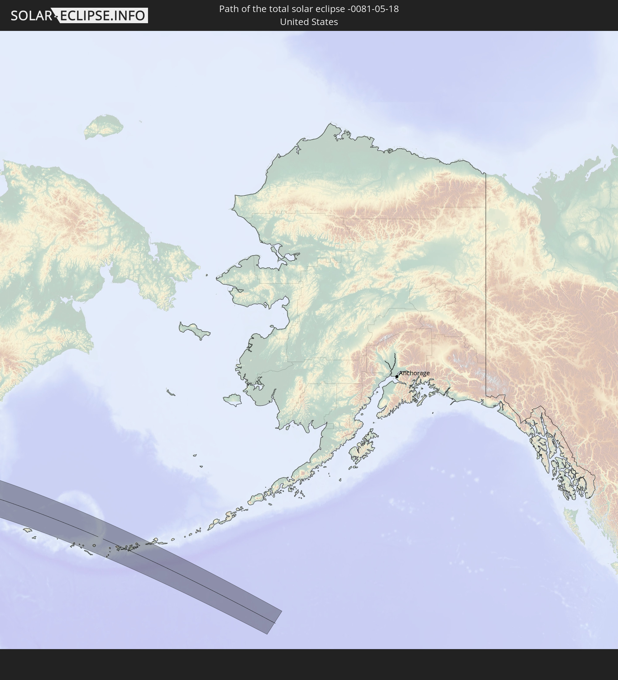 United States
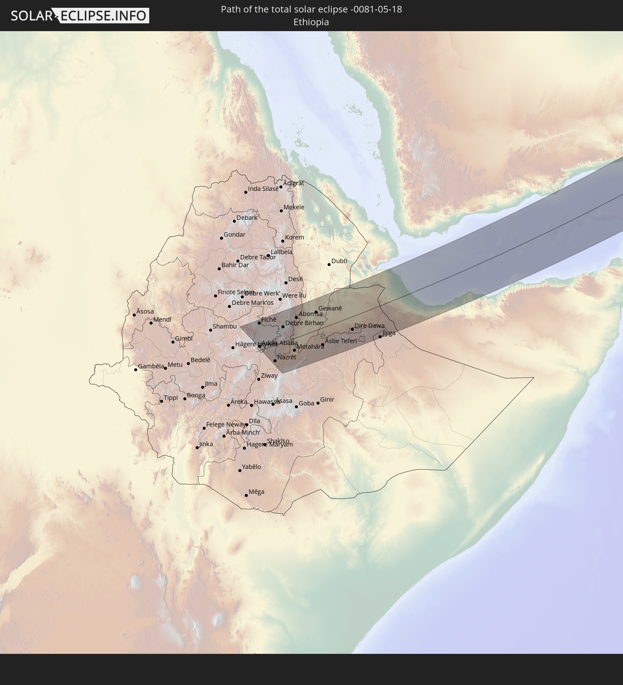 Ethiopia
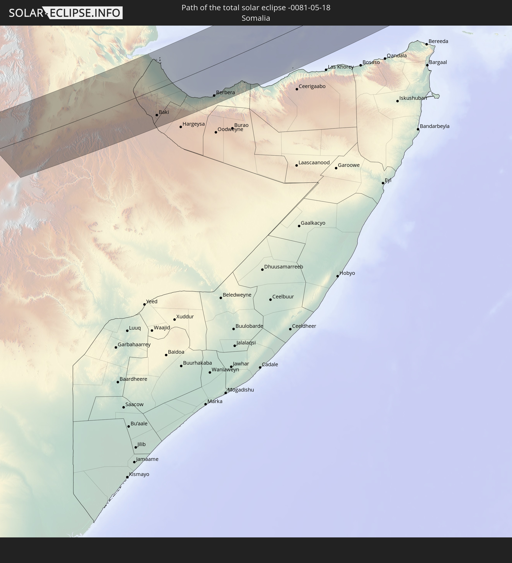 Somalia
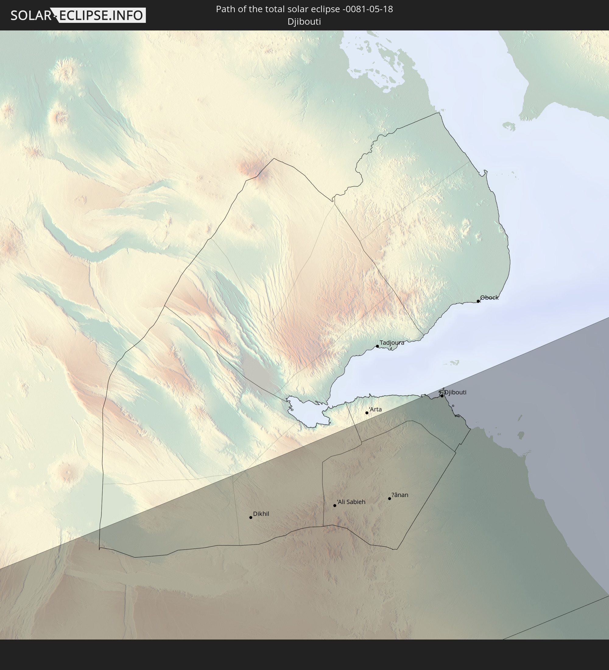 Djibouti
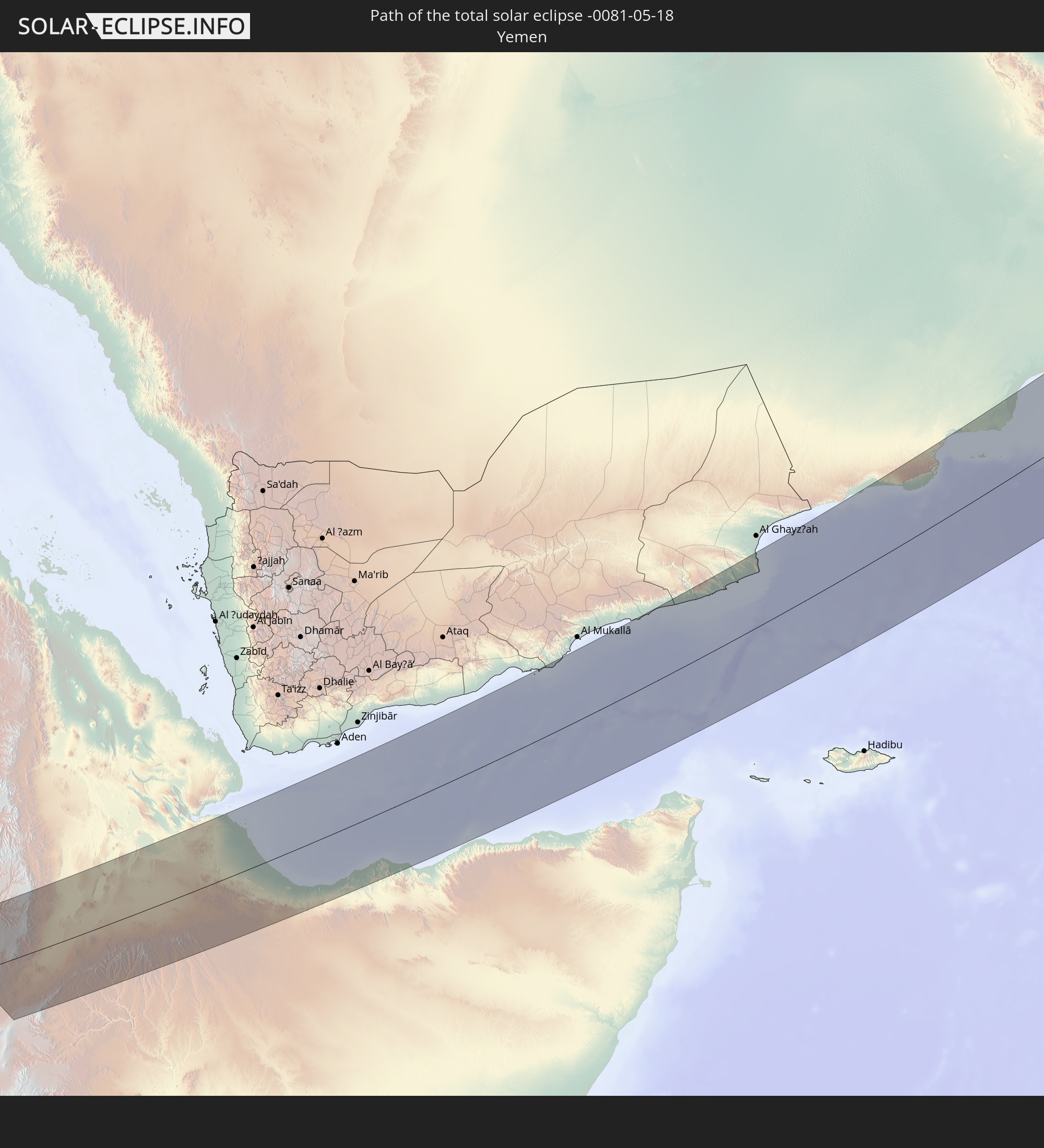 Yemen
Yemen
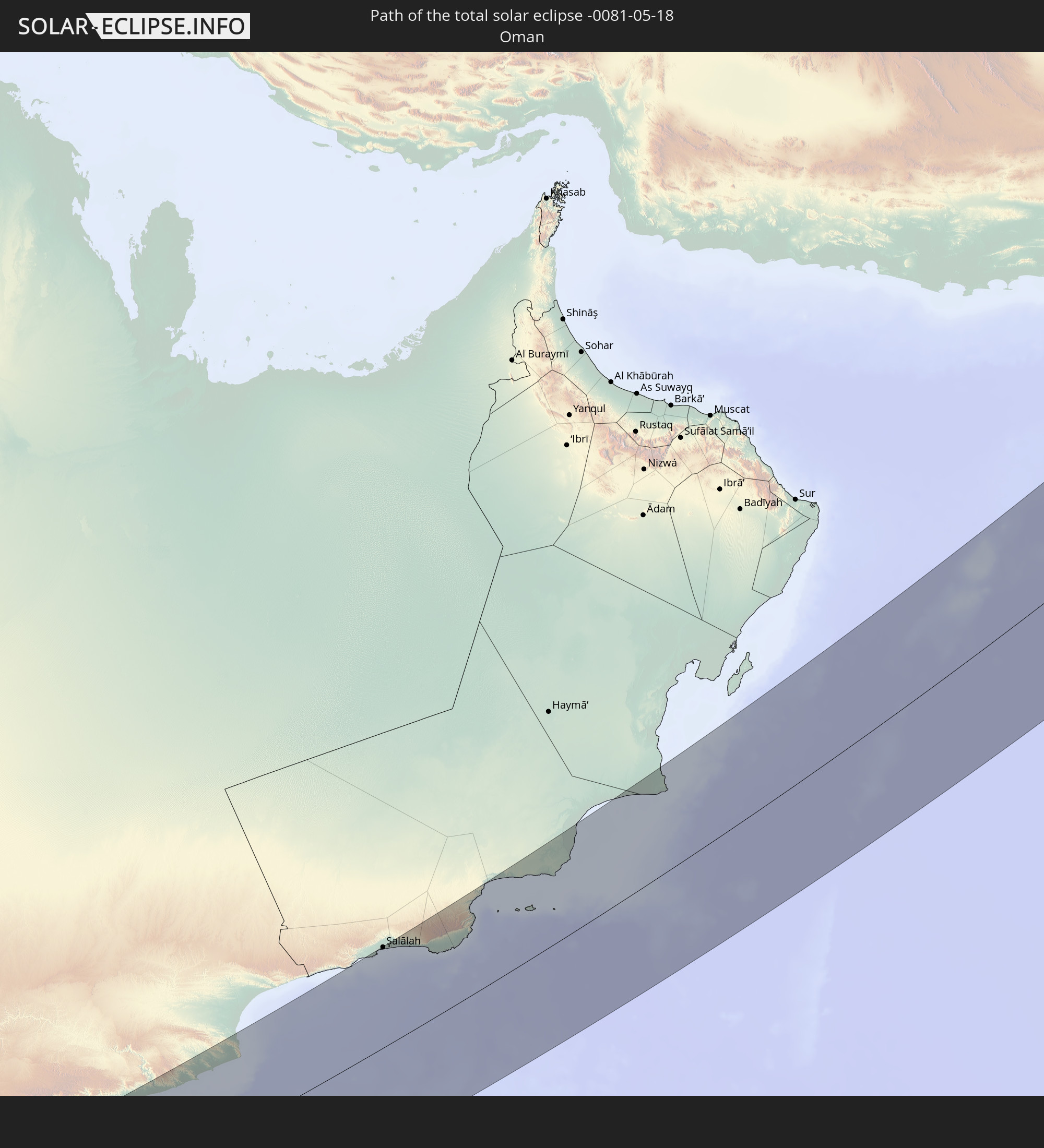 Oman
Oman
 Pakistan
 India
India
 China
China
 Mongolia
In den folgenden Ländern ist die Sonnenfinsternis partiell zu sehen
 Russia
 United States
 United States Minor Outlying Islands
 Canada
 Greenland
 Iceland
 Svalbard and Jan Mayen
 United Kingdom
 Faroe Islands
 France
 Isle of Man
 Belgium
 Netherlands
 Norway
 Luxembourg
 Germany
 Switzerland
 Italy
Italy
 Denmark
 Libya
Libya
 Liechtenstein
 Austria
 Sweden
 Czechia
 San Marino
 Vatican City
 Slovenia
 Croatia
 Poland
 Bosnia and Herzegovina
 Hungary
 Slovakia
 Montenegro
 Serbia
 Albania
 Åland Islands
 Greece
 Romania
 Republic of Macedonia
 Finland
 Lithuania
 Latvia
 Estonia
 Sudan
Sudan
 Ukraine
 Bulgaria
 Belarus
 Egypt
Egypt
 Turkey
 Moldova
 Cyprus
 Ethiopia
 Kenya
Kenya
 State of Palestine
 Israel
 Saudi Arabia
 Jordan
 Lebanon
 Syria
Syria
 Eritrea
 Iraq
Iraq
 Georgia
 French Southern and Antarctic Lands
 Somalia
 Djibouti
 Yemen
Yemen
 Armenia
 Iran
Iran
 Azerbaijan
 Seychelles
 Kazakhstan
 Kuwait
 Bahrain
 Qatar
Qatar
 United Arab Emirates
 Oman
Oman
 Turkmenistan
 Uzbekistan
 Mauritius
 Afghanistan
 Pakistan
 Tajikistan
 India
India
 Kyrgyzstan
 British Indian Ocean Territory
 Maldives
 China
China
 Sri Lanka
 Nepal
Nepal
 Mongolia
 Bangladesh
 Bhutan
 Myanmar
 Indonesia
 Thailand
 Laos
Laos
 Vietnam
 Cambodia
 Macau
Macau
 Hong Kong
 Taiwan
 Japan
Japan
 North Korea
 South Korea
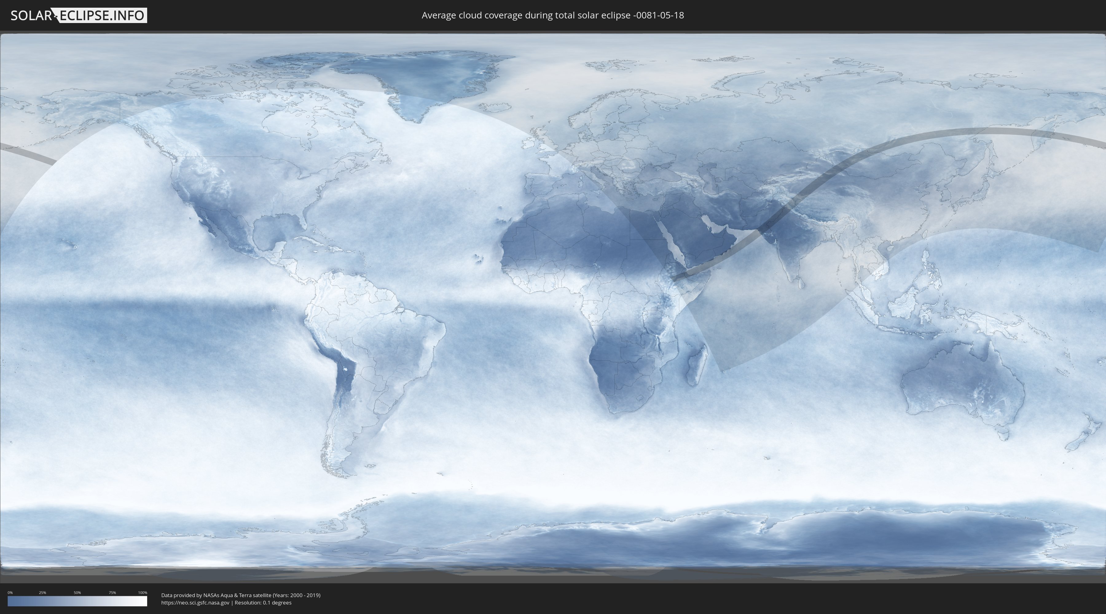
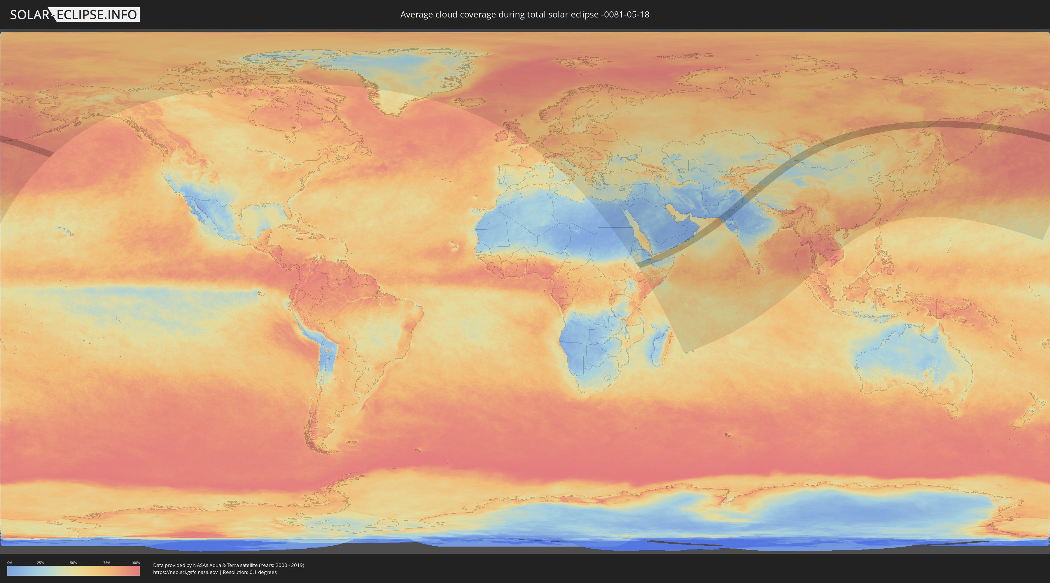
How will be the weather during the total solar eclipse on 05/18/-0081?
Where is the best place to see the total solar eclipse of 05/18/-0081?
The following maps show the average cloud coverage for the day of the total solar eclipse.
With the help of these maps, it is possible to find the place along the eclipse path, which has the best
chance of a cloudless sky.
Nevertheless, you should consider local circumstances and inform about the weather of your chosen
observation site.
The data is provided by NASAs satellites
AQUA and TERRA.
The cloud maps are averaged over a period of 19 years (2000 - 2019).
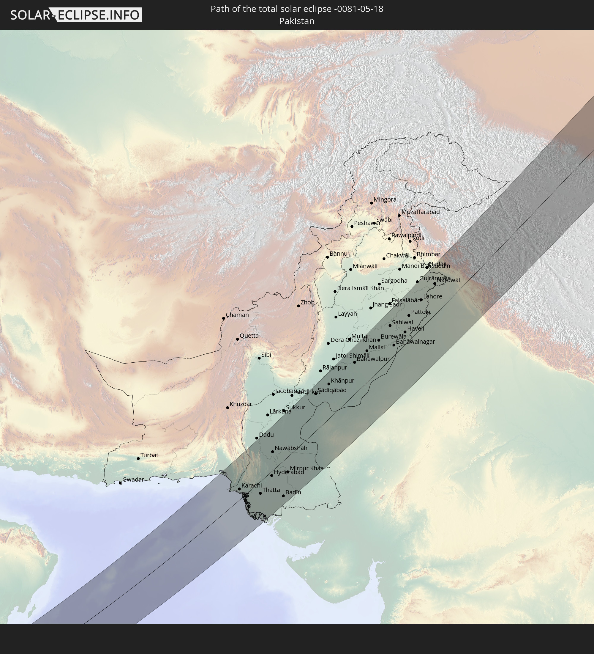
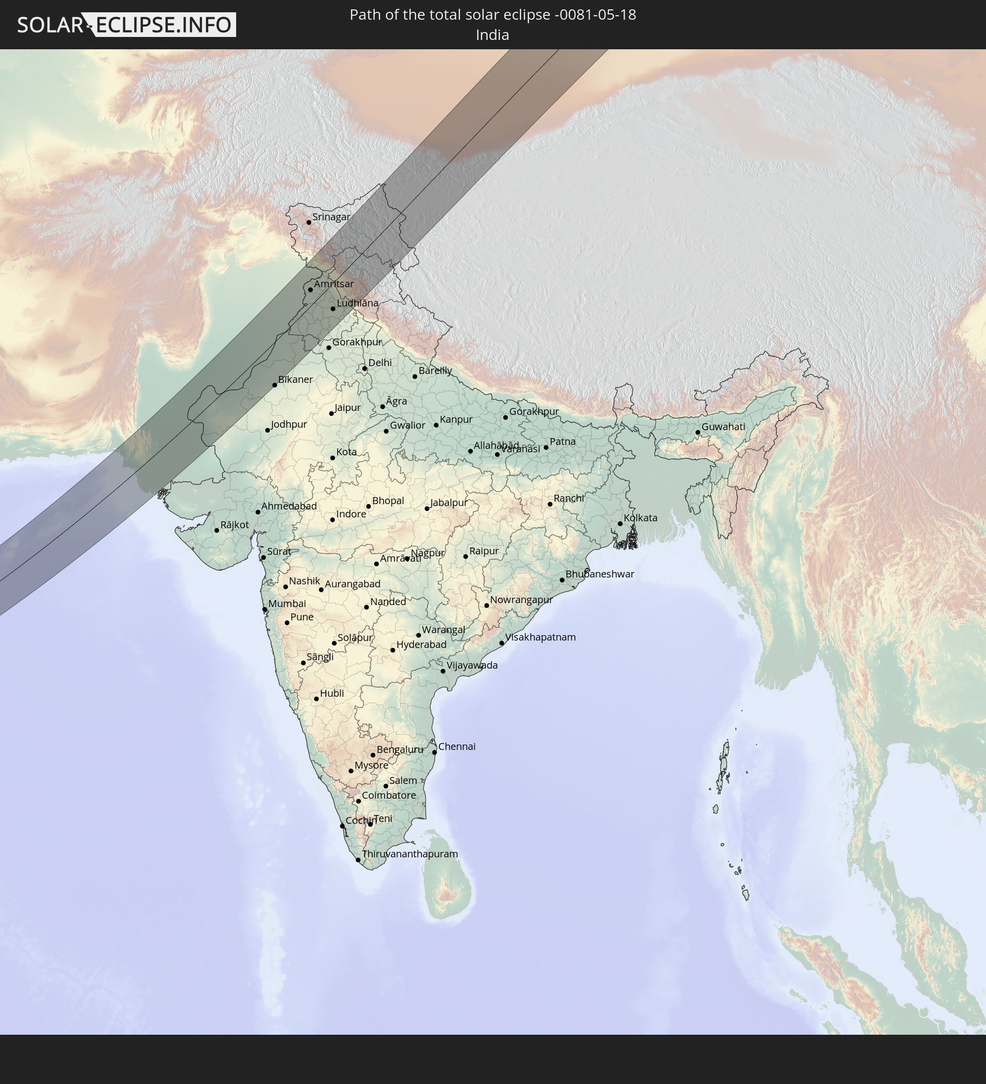
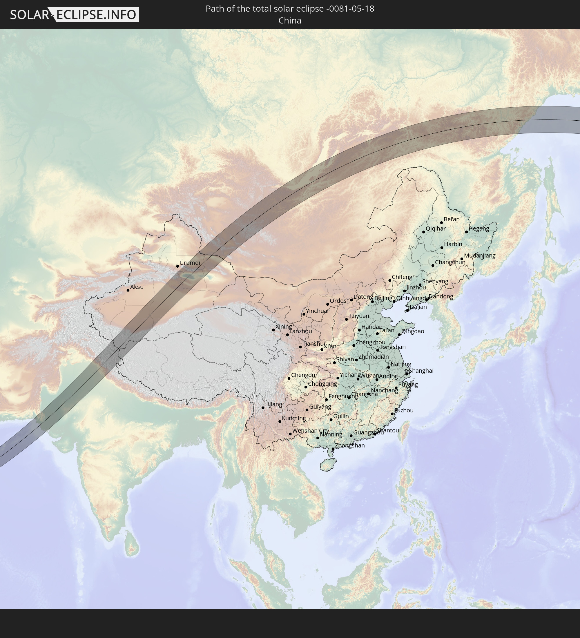
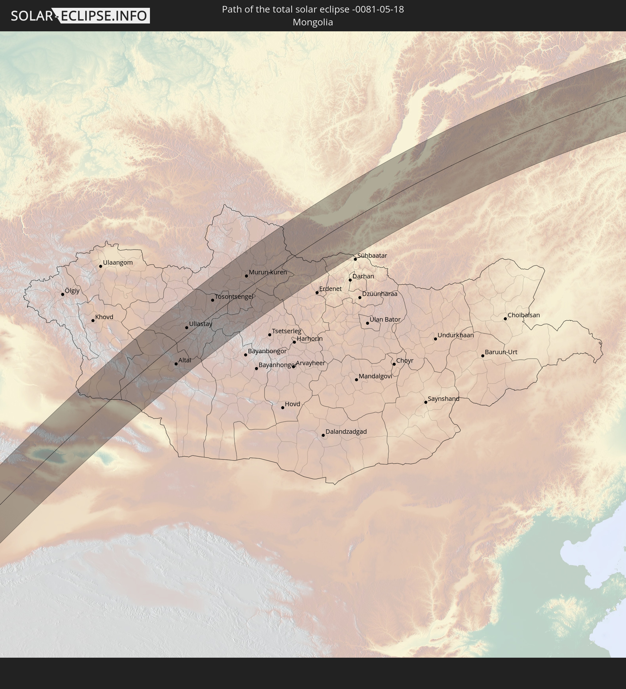
Detailed country maps
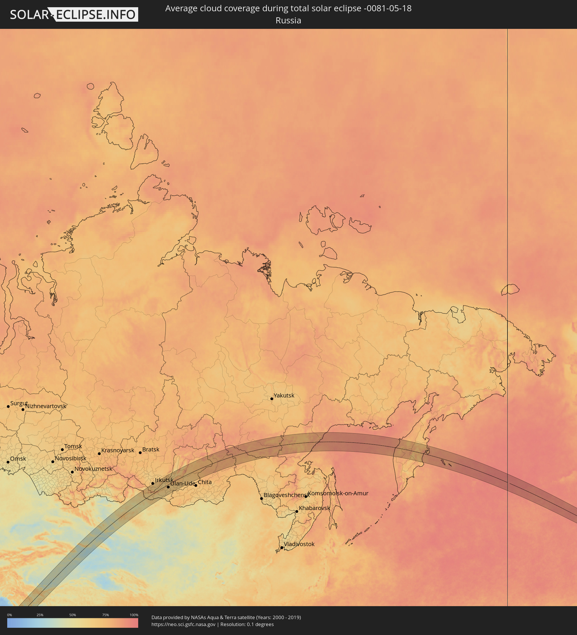 Russia
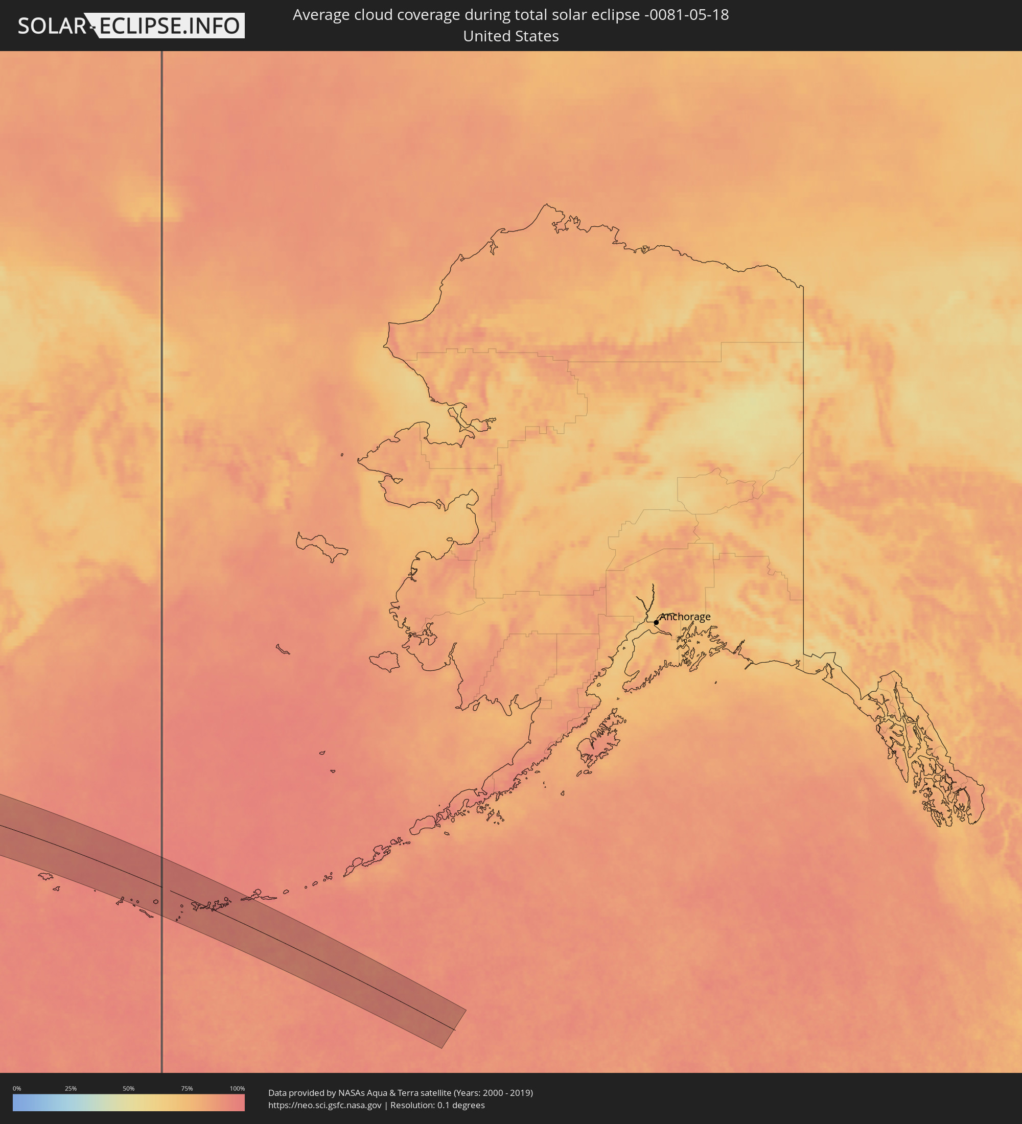 United States
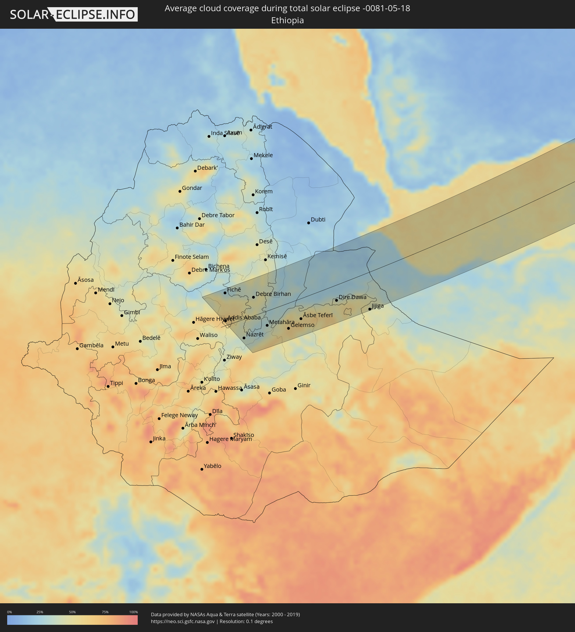 Ethiopia
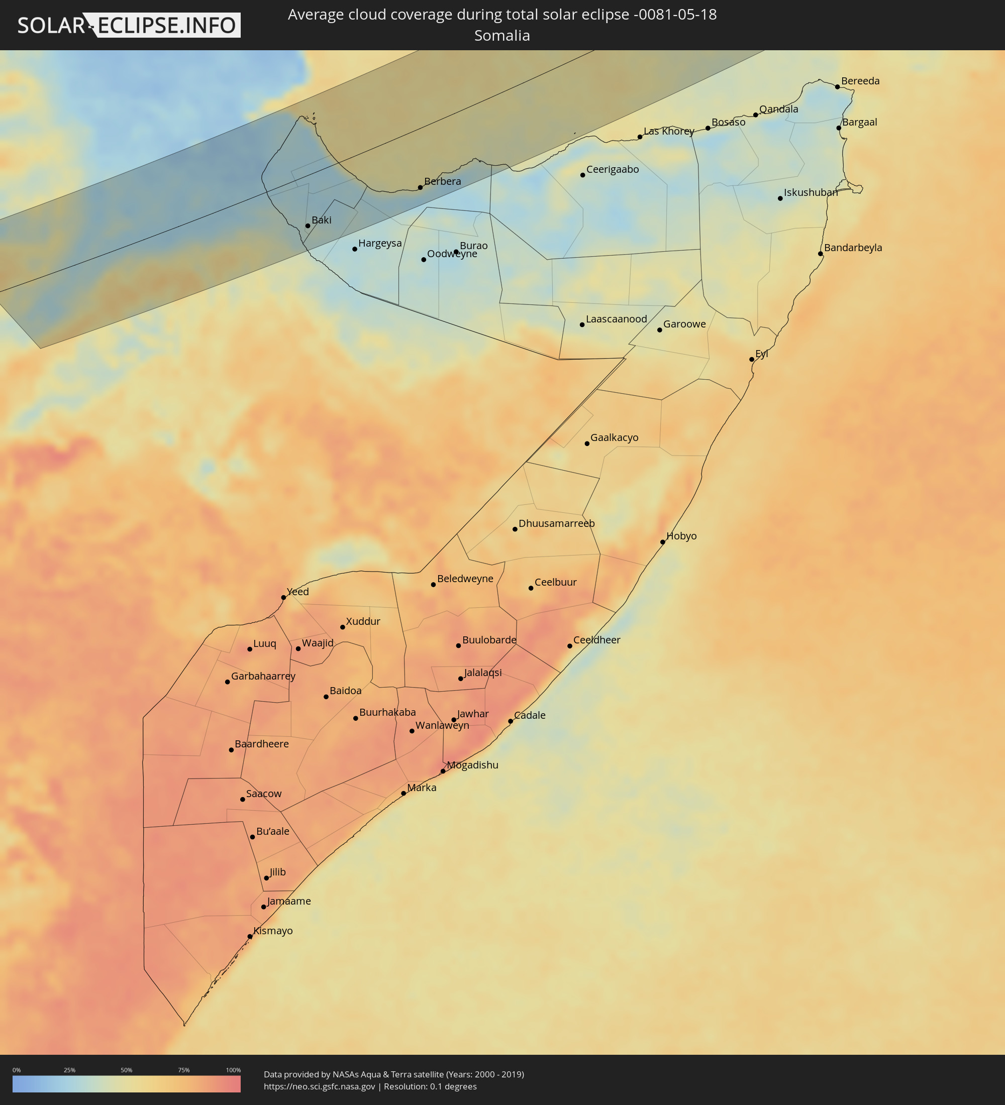 Somalia
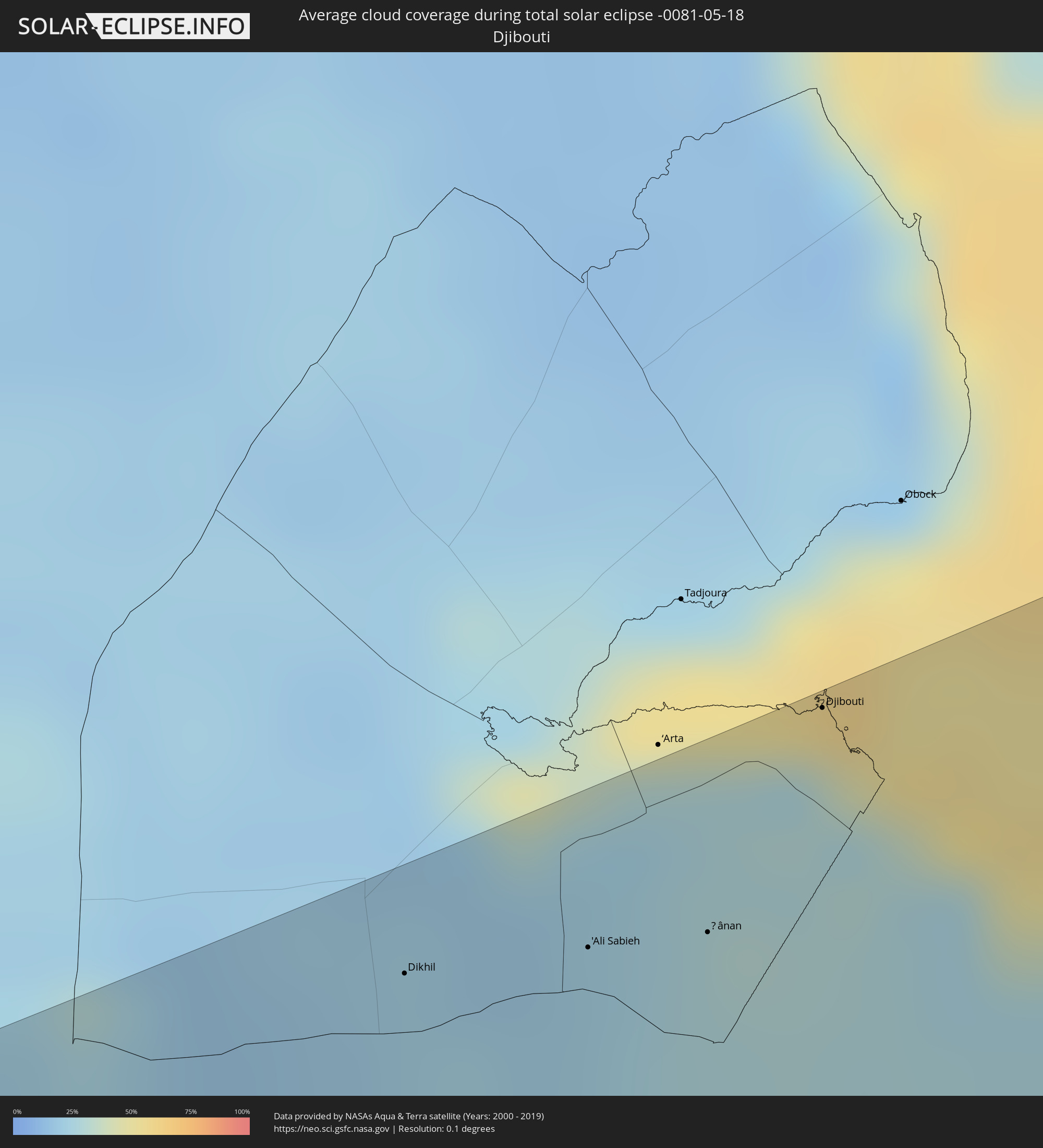 Djibouti
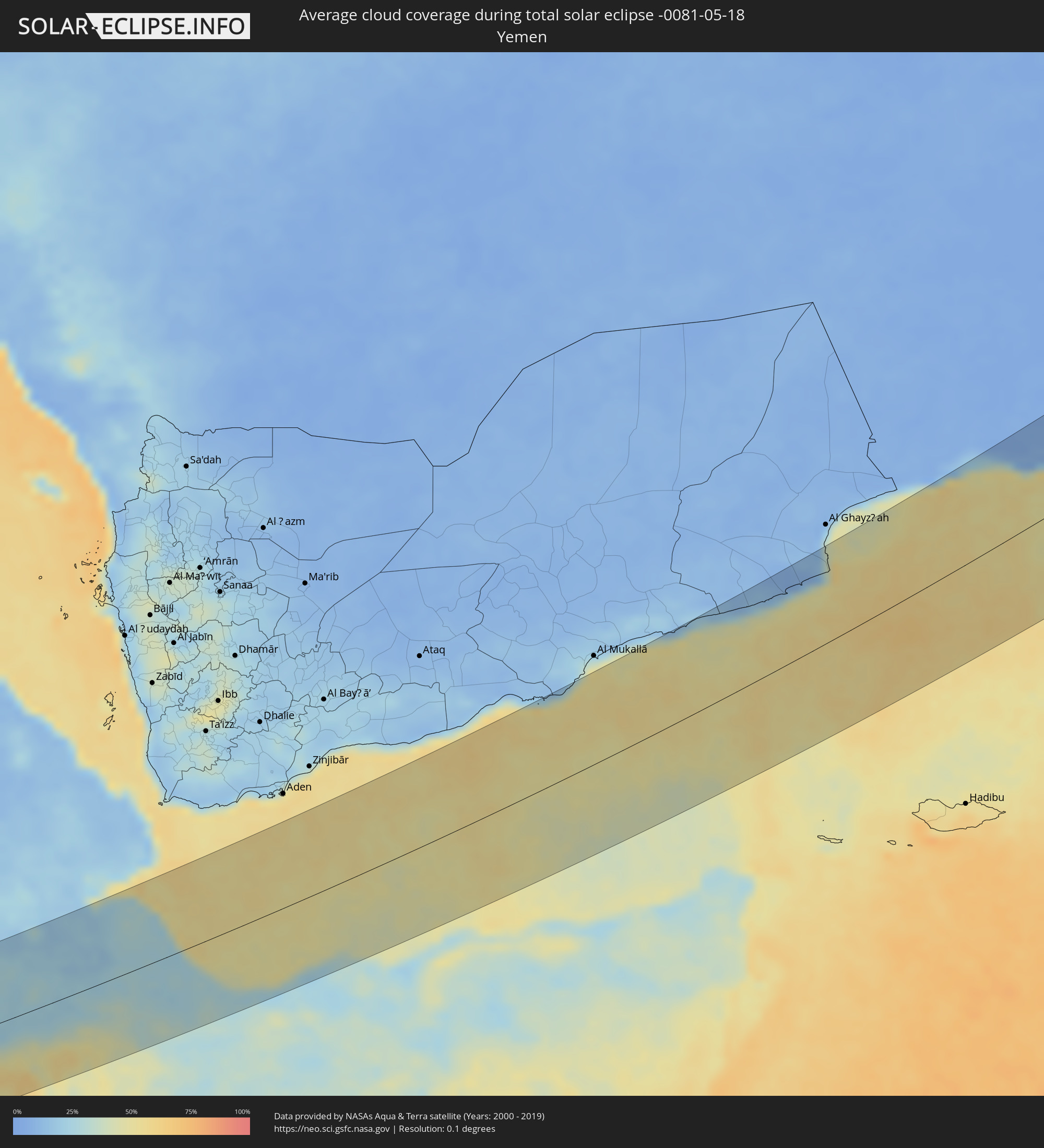 Yemen
Yemen
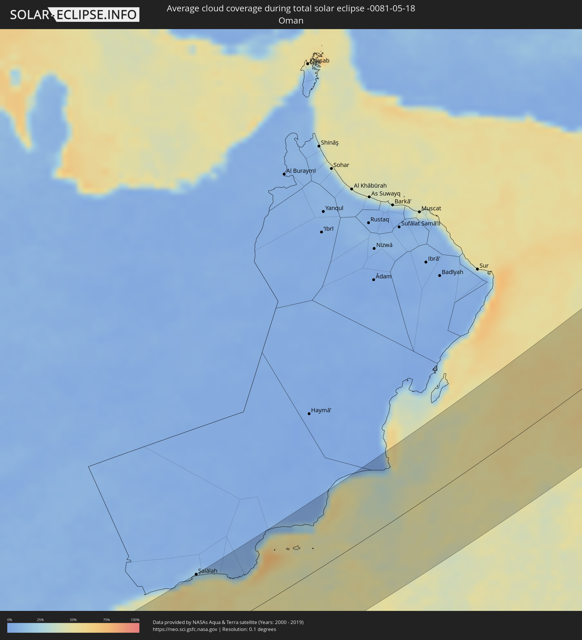 Oman
Oman
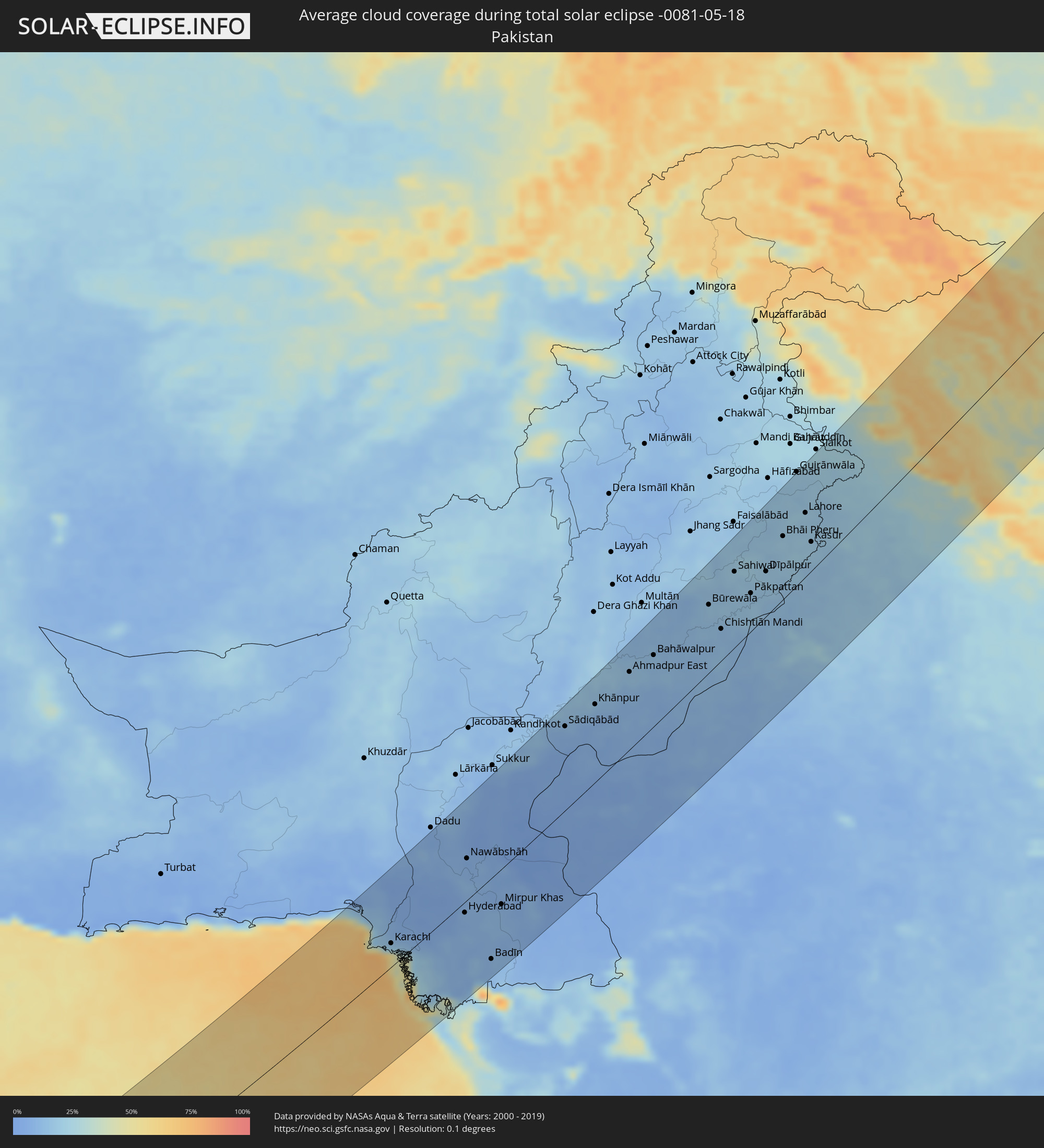 Pakistan
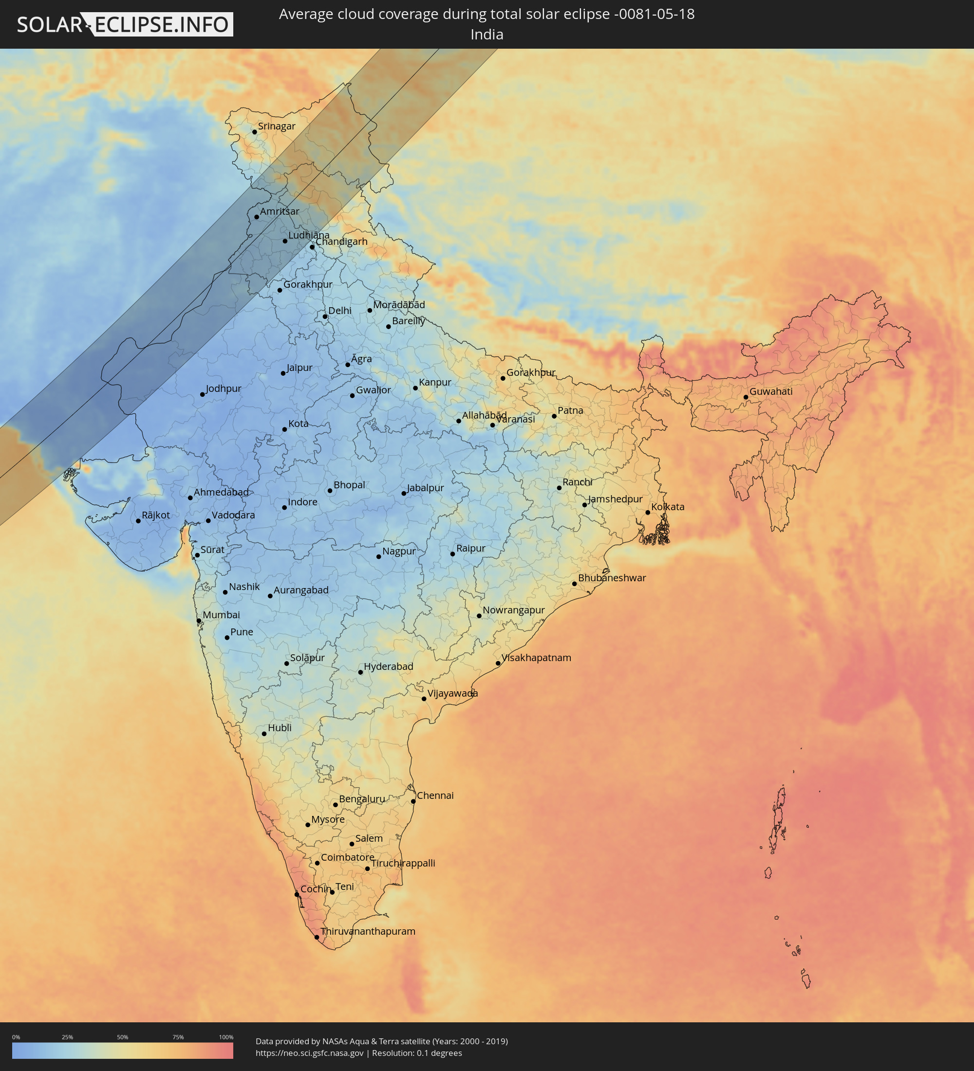 India
India
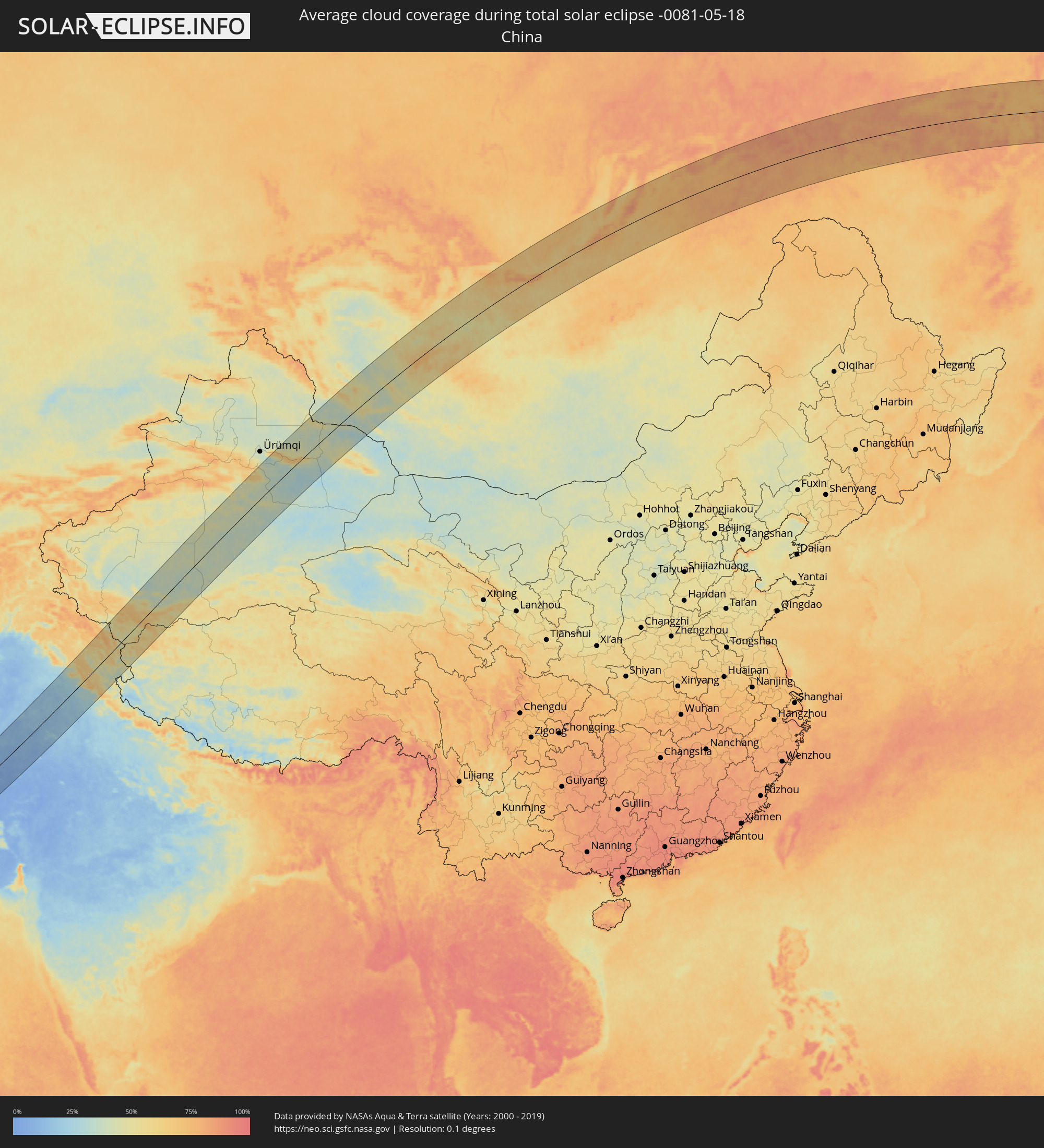 China
China
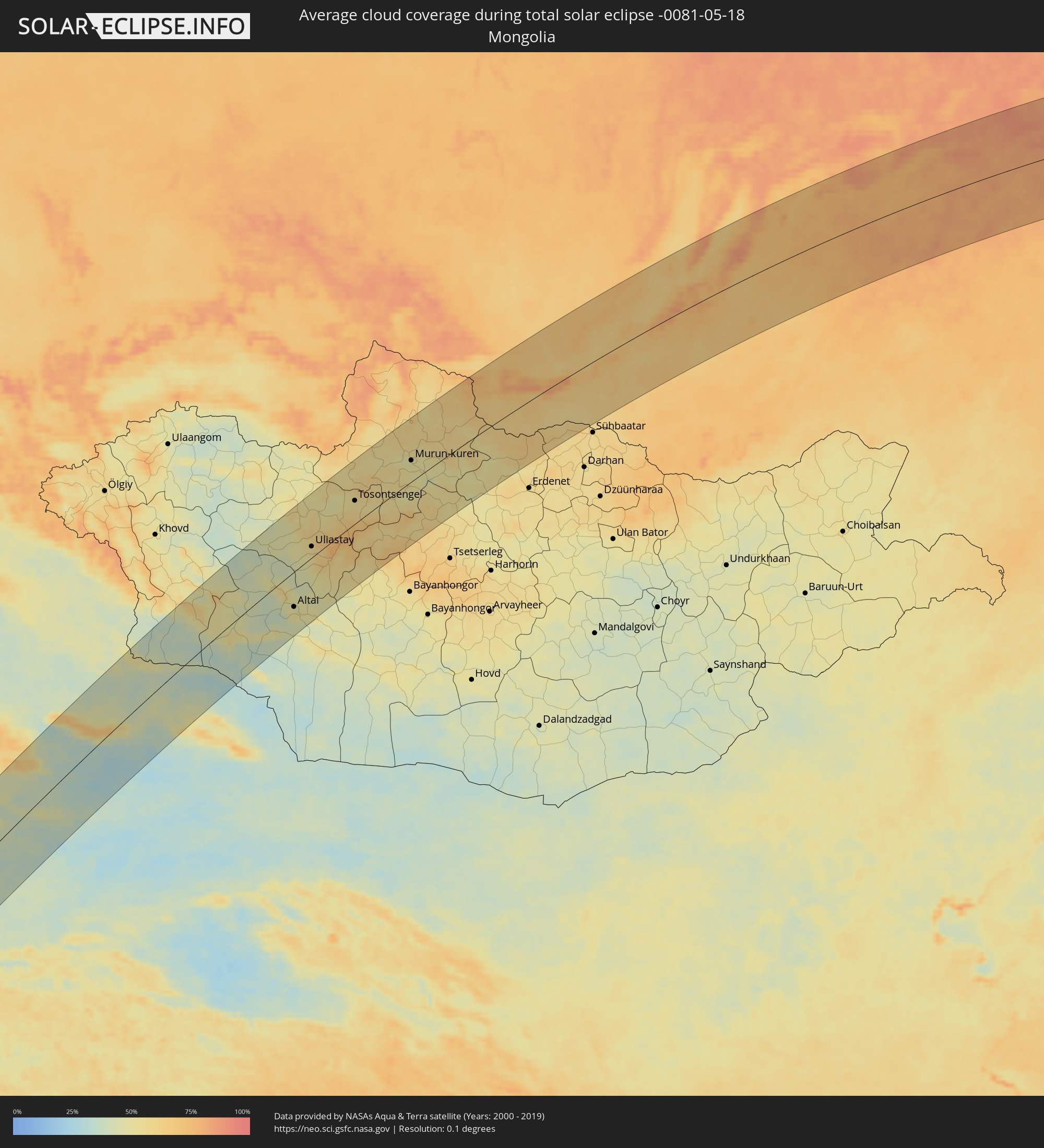 Mongolia
Cities inside the path of the eclipse
The following table shows all locations with a population of more than 5,000 inside the eclipse path. Cities which have more than 100,000 inhabitants are marked bold. A click at the locations opens a detailed map.
| City | Type | Eclipse duration | Local time of max. eclipse | Distance to central line | Ø Cloud coverage |
|
Gebre Guracha, Oromiya
|
total | - | 05:34:16 UTC+02:27 | 107 km | 49% |
|
Fichē, Oromiya
|
total | - | 05:34:10 UTC+02:27 | 95 km | 39% |
|
Addis Ababa, Addis Ababa
|
total | - | 05:33:26 UTC+02:27 | 13 km | 60% |
|
Bishoftu, Oromiya
|
total | - | 05:33:06 UTC+02:27 | 24 km | 48% |
|
Sendafa, Oromiya
|
total | - | 05:33:28 UTC+02:27 | 16 km | 59% |
|
Mojo, Oromiya
|
total | - | 05:32:54 UTC+02:27 | 47 km | 34% |
|
Nazrēt, Oromiya
|
total | - | 05:32:49 UTC+02:27 | 56 km | 36% |
|
Wenjī, Oromiya
|
total | - | 05:32:43 UTC+02:27 | 67 km | 37% |
|
Sirre, Oromiya
|
total | - | 05:32:32 UTC+02:27 | 88 km | 52% |
|
Debre Birhan, Amhara
|
total | - | 05:33:49 UTC+02:27 | 53 km | 48% |
|
Debre Sīna, Amhara
|
total | - | 05:33:55 UTC+02:27 | 62 km | 48% |
|
Metahāra, Oromiya
|
total | - | 05:32:57 UTC+02:27 | 43 km | 36% |
|
Abomsa, Amhara
|
total | - | 05:33:59 UTC+02:27 | 68 km | 40% |
|
Āwash, Āfar
|
total | - | 05:32:57 UTC+02:27 | 44 km | 44% |
|
Gelemso, Oromiya
|
total | - | 05:32:42 UTC+02:27 | 74 km | 59% |
|
Gewanē, Āfar
|
total | - | 05:33:59 UTC+02:27 | 62 km | 30% |
|
Bedēsa, Oromiya
|
total | - | 05:32:42 UTC+02:27 | 76 km | 57% |
|
Āsbe Teferī, Oromiya
|
total | - | 05:32:51 UTC+02:27 | 60 km | 56% |
|
Hīrna, Oromiya
|
total | - | 05:32:55 UTC+02:27 | 55 km | 57% |
|
Deder, Oromiya
|
total | - | 05:32:55 UTC+02:27 | 58 km | 58% |
|
Dire Dawa, Dire Dawa
|
total | - | 05:33:05 UTC+02:27 | 46 km | 46% |
|
Harar, Harari
|
total | - | 05:32:45 UTC+02:27 | 85 km | 55% |
|
Dikhil, Dikhil
|
total | - | 05:34:31 UTC+02:27 | 91 km | 22% |
|
'Ali Sabieh, Ali Sabieh
|
total | - | 05:34:29 UTC+02:27 | 82 km | 22% |
|
Jijiga, Somali
|
total | - | 05:32:37 UTC+02:27 | 108 km | 43% |
|
Ḏânan, Ali Sabieh
|
total | - | 05:34:28 UTC+02:27 | 76 km | 27% |
|
Djibouti, Djibouti
|
total | - | 05:34:51 UTC+02:27 | 109 km | 29% |
|
Baki, Awdal
|
total | - | 05:33:02 UTC+02:27 | 76 km | 35% |
|
Berbera, Woqooyi Galbeed
|
total | - | 05:33:17 UTC+02:27 | 88 km | 24% |
|
Şalālah, Z̧ufār
|
total | - | 06:54:43 UTC+03:41 | 122 km | 45% |
|
Karachi, Sindh
|
total | - | 07:57:58 UTC+04:28 | 32 km | 22% |
|
Hyderabad, Sindh
|
total | - | 07:59:33 UTC+04:28 | 14 km | 9% |
|
Nawābshāh, Sindh
|
total | - | 08:01:03 UTC+04:28 | 54 km | 8% |
|
Tando Ādam, Sindh
|
total | - | 08:00:22 UTC+04:28 | 2 km | 8% |
|
Tando Allāhyār, Sindh
|
total | - | 07:59:53 UTC+04:28 | 31 km | 9% |
|
Mirpur Khas, Sindh
|
total | - | 08:00:10 UTC+04:28 | 46 km | 11% |
|
Sādiqābād, Punjab
|
total | - | 08:05:47 UTC+04:28 | 106 km | 9% |
|
Khānpur, Punjab
|
total | - | 08:06:45 UTC+04:28 | 97 km | 10% |
|
Ahmadpur East, Punjab
|
total | - | 08:08:04 UTC+04:28 | 96 km | 15% |
|
Bahāwalpur, Punjab
|
total | - | 08:08:51 UTC+04:28 | 87 km | 13% |
|
Būrewāla, Punjab
|
total | - | 08:10:59 UTC+04:28 | 82 km | 17% |
|
Chishtiān Mandi, Punjab
|
total | - | 08:10:29 UTC+04:28 | 38 km | 12% |
|
Sahiwal, Punjab
|
total | - | 08:12:15 UTC+04:28 | 91 km | 20% |
|
Bahāwalnagar, Punjab
|
total | - | 08:11:09 UTC+04:28 | 28 km | 18% |
|
Pākpattan, Punjab
|
total | - | 08:11:53 UTC+04:28 | 46 km | 16% |
|
Bahāwalnagar, Punjab
|
total | - | 08:12:17 UTC+04:28 | 62 km | 17% |
|
Jarānwāla, Punjab
|
total | - | 08:13:45 UTC+04:28 | 120 km | 17% |
|
Okāra, Punjab
|
total | - | 08:12:48 UTC+04:28 | 78 km | 21% |
|
Gangānagar, Rajasthan
|
total | - | 09:04:29 UTC+05:21 | 21 km | 14% |
|
Sheikhupura, Punjab
|
total | - | 08:14:54 UTC+04:28 | 113 km | 18% |
|
Abohar, Punjab
|
total | - | 09:05:10 UTC+05:21 | 25 km | 14% |
|
Kamoke, Punjab
|
total | - | 08:15:35 UTC+04:28 | 116 km | 19% |
|
Murīdke, Punjab
|
total | - | 08:15:18 UTC+04:28 | 100 km | 17% |
|
Hanumāngarh, Rajasthan
|
total | - | 09:04:14 UTC+05:21 | 78 km | 23% |
|
Lahore, Punjab
|
total | - | 08:14:54 UTC+04:28 | 75 km | 19% |
|
Kasūr, Punjab
|
total | - | 08:14:11 UTC+04:28 | 34 km | 20% |
|
Muktsar, Punjab
|
total | - | 09:06:02 UTC+05:21 | 21 km | 15% |
|
Ferozepore, Punjab
|
total | - | 09:06:57 UTC+05:21 | 8 km | 17% |
|
Kotkapura, Punjab
|
total | - | 09:06:30 UTC+05:21 | 34 km | 17% |
|
Jammu, Kashmir
|
total | - | 09:10:31 UTC+05:21 | 131 km | 22% |
|
Amritsar, Punjab
|
total | - | 09:08:28 UTC+05:21 | 45 km | 18% |
|
Bhatinda, Punjab
|
total | - | 09:05:54 UTC+05:21 | 70 km | 17% |
|
Sirsa, Haryana
|
total | - | 09:04:44 UTC+05:21 | 130 km | 17% |
|
Udhampur, Kashmir
|
total | - | 09:11:06 UTC+05:21 | 128 km | 26% |
|
Moga, Punjab
|
total | - | 09:07:13 UTC+05:21 | 38 km | 20% |
|
Batāla, Punjab
|
total | - | 09:09:06 UTC+05:21 | 37 km | 22% |
|
Kapūrthala, Punjab
|
total | - | 09:08:27 UTC+05:21 | 9 km | 22% |
|
Mānsa, Punjab
|
total | - | 09:05:54 UTC+05:21 | 119 km | 20% |
|
Barnāla, Punjab
|
total | - | 09:06:44 UTC+05:21 | 99 km | 18% |
|
Jalandhar, Punjab
|
total | - | 09:08:32 UTC+05:21 | 26 km | 21% |
|
Pathānkot, Punjab
|
total | - | 09:10:21 UTC+05:21 | 43 km | 28% |
|
Phagwāra, Punjab
|
total | - | 09:08:31 UTC+05:21 | 47 km | 20% |
|
Sangrūr, Punjab
|
total | - | 09:06:46 UTC+05:21 | 129 km | 18% |
|
Ludhiāna, Punjab
|
total | - | 09:08:00 UTC+05:21 | 77 km | 18% |
|
Māler Kotla, Punjab
|
total | - | 09:07:19 UTC+05:21 | 109 km | 18% |
|
Khanna, Punjab
|
total | - | 09:07:57 UTC+05:21 | 118 km | 20% |
|
Hotan, Xinjiang Uyghur Autonomous Region
|
total | - | 12:02:24 UTC+08:00 | 128 km | 48% |
|
Korla, Xinjiang Uyghur Autonomous Region
|
total | - | 12:17:57 UTC+08:00 | 99 km | 43% |
|
Sishilichengzi, Xinjiang Uyghur Autonomous Region
|
total | - | 12:18:41 UTC+08:00 | 95 km | 45% |
|
Turpan, Xinjiang Uyghur Autonomous Region
|
total | - | 12:23:46 UTC+08:00 | 18 km | 35% |
|
Altai, Govĭ-Altay
|
total | - | 10:45:16 UTC+06:06 | 69 km | 46% |
|
Uliastay, Dzabkhan
|
total | - | 10:47:59 UTC+06:06 | 22 km | 54% |
|
Tosontsengel, Dzabkhan
|
total | - | 10:51:17 UTC+06:06 | 45 km | 53% |
|
Murun-kuren, Hövsgöl
|
total | - | 11:55:51 UTC+07:07 | 42 km | 47% |
|
Zakamensk, Respublika Buryatiya
|
total | - | 11:50:30 UTC+06:57 | 18 km | 61% |
|
Slyudyanka, Irkutsk
|
total | - | 11:52:22 UTC+06:57 | 86 km | 69% |
|
Shelekhov, Irkutsk
|
total | - | 11:53:25 UTC+06:57 | 123 km | 67% |
|
Baykal’sk, Irkutsk
|
total | - | 11:52:48 UTC+06:57 | 56 km | 73% |
|
Markova, Irkutsk
|
total | - | 11:53:33 UTC+06:57 | 119 km | 67% |
|
Petropavlovka, Respublika Buryatiya
|
total | - | 11:53:33 UTC+06:57 | 73 km | 59% |
|
Gusinoozyorsk, Respublika Buryatiya
|
total | - | 11:55:48 UTC+06:57 | 51 km | 64% |
|
Kabansk, Respublika Buryatiya
|
total | - | 11:56:40 UTC+06:57 | 17 km | 66% |
|
Ivolginsk, Respublika Buryatiya
|
total | - | 11:57:16 UTC+06:57 | 34 km | 63% |
|
Sokol, Respublika Buryatiya
|
total | - | 11:57:31 UTC+06:57 | 34 km | 61% |
|
Zarechnyy, Respublika Buryatiya
|
total | - | 11:57:40 UTC+06:57 | 32 km | 62% |
|
Ulan-Ude, Respublika Buryatiya
|
total | - | 11:57:46 UTC+06:57 | 37 km | 62% |
|
Turuntayevo, Respublika Buryatiya
|
total | - | 11:58:07 UTC+06:57 | 2 km | 66% |
|
Onokhoy, Respublika Buryatiya
|
total | - | 11:58:28 UTC+06:57 | 43 km | 63% |
|
Ust’-Barguzin, Respublika Buryatiya
|
total | - | 12:00:51 UTC+06:57 | 70 km | 64% |
|
Barguzin, Respublika Buryatiya
|
total | - | 12:01:46 UTC+06:57 | 72 km | 66% |
|
Khorinsk, Respublika Buryatiya
|
total | - | 12:00:58 UTC+06:57 | 75 km | 64% |
|
Kizhinga, Respublika Buryatiya
|
total | - | 12:00:56 UTC+06:57 | 111 km | 64% |
|
Kurumkan, Respublika Buryatiya
|
total | - | 12:03:04 UTC+06:57 | 121 km | 64% |
|
Neryungri, Sakha
|
total | - | 14:02:46 UTC+08:38 | 45 km | 78% |
|
Tynda, Amur
|
total | - | 14:03:01 UTC+08:38 | 120 km | 75% |
|
Chul’man, Sakha
|
total | - | 14:03:03 UTC+08:38 | 60 km | 80% |
|
Klyuchi, Kamtsjatka
|
total | - | 16:28:19 UTC+10:34 | 10 km | 78% |