Total solar eclipse of 04/06/-0126
| Day of week: | Saturday |
| Maximum duration of eclipse: | 04m48s |
| Maximum width of eclipse path: | 255 km |
| Saros cycle: | 56 |
| Coverage: | 100% |
| Magnitude: | 1.0623 |
| Gamma: | 0.6041 |
Wo kann man die Sonnenfinsternis vom 04/06/-0126 sehen?
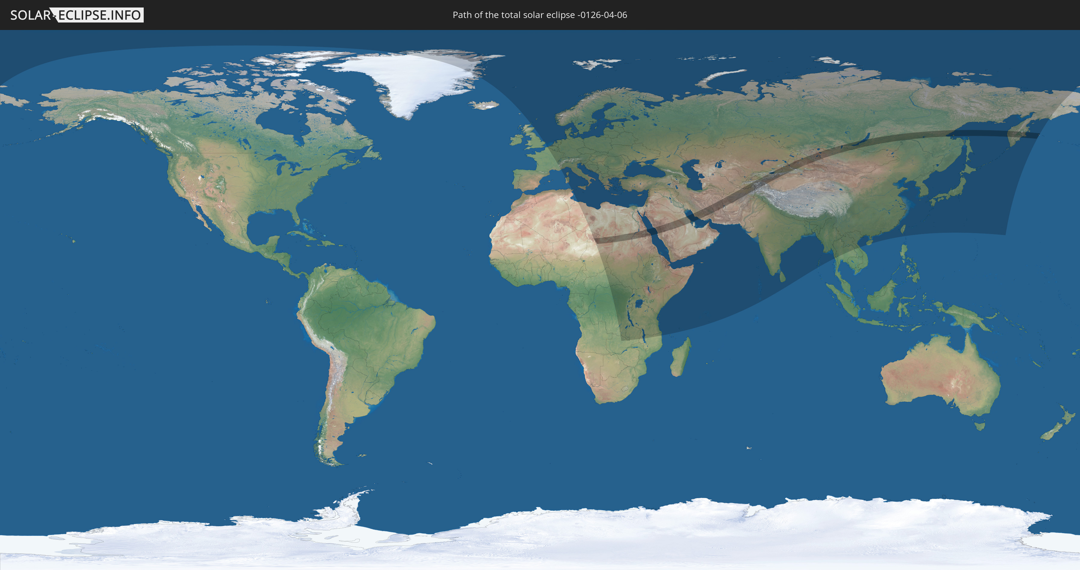
Die Sonnenfinsternis am 04/06/-0126 kann man in 106 Ländern als partielle Sonnenfinsternis beobachten.
Der Finsternispfad verläuft durch 15 Länder. Nur in diesen Ländern ist sie als total Sonnenfinsternis zu sehen.
In den folgenden Ländern ist die Sonnenfinsternis total zu sehen
 Russia
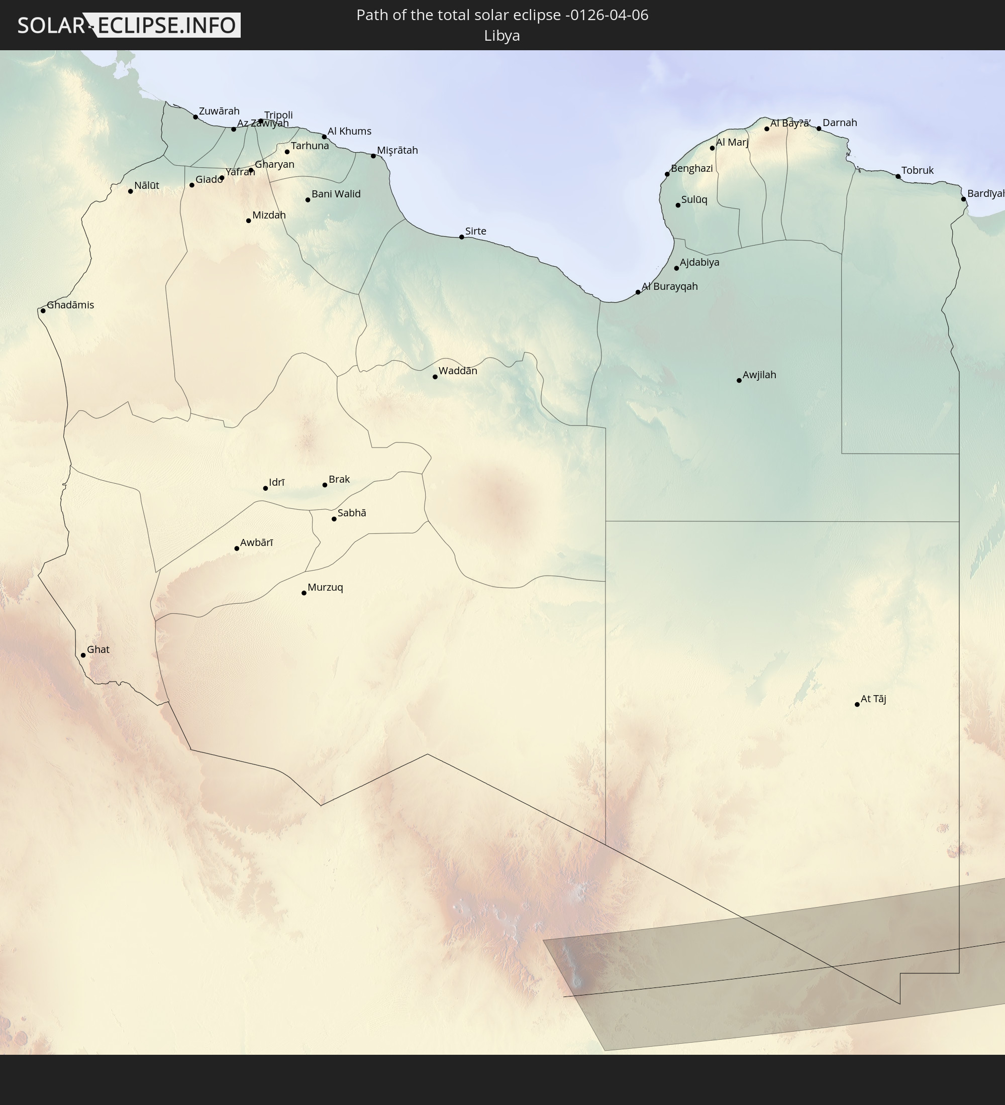 Libya
Libya
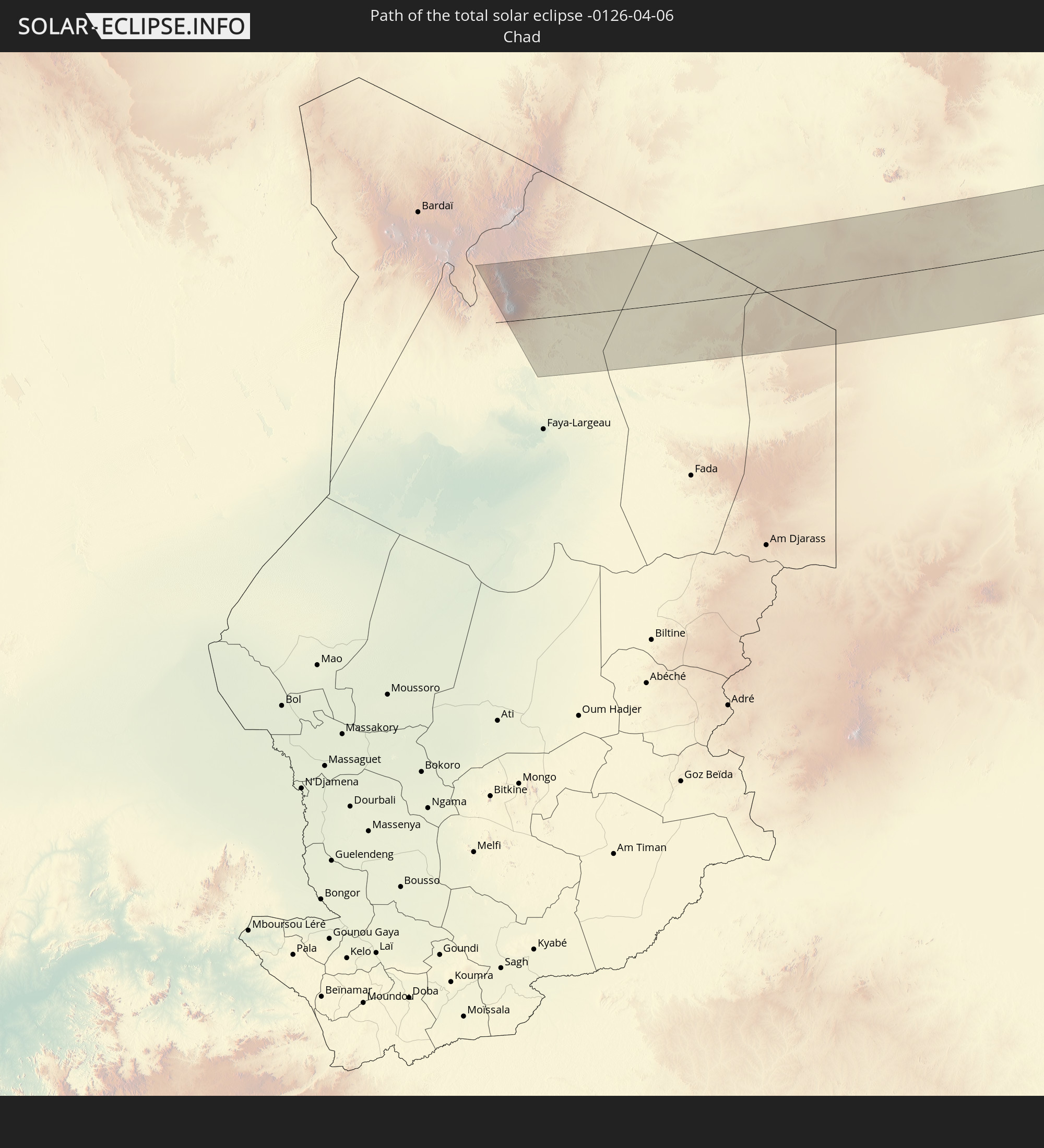 Chad
Chad
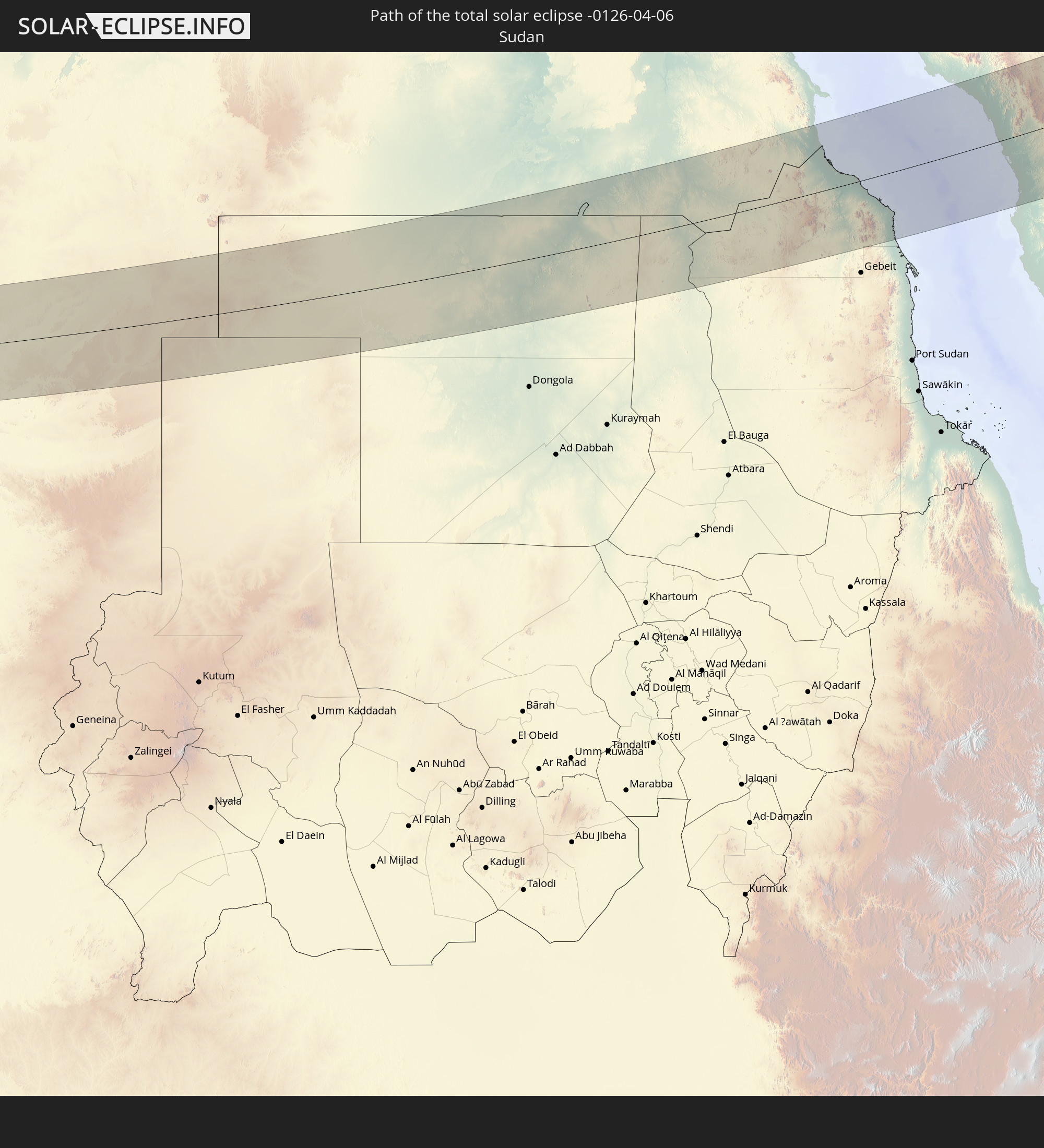 Sudan
Sudan
 Egypt
Egypt
 Saudi Arabia
 Iran
Iran
 Kazakhstan
 Bahrain
 Uzbekistan
 Afghanistan
 Tajikistan
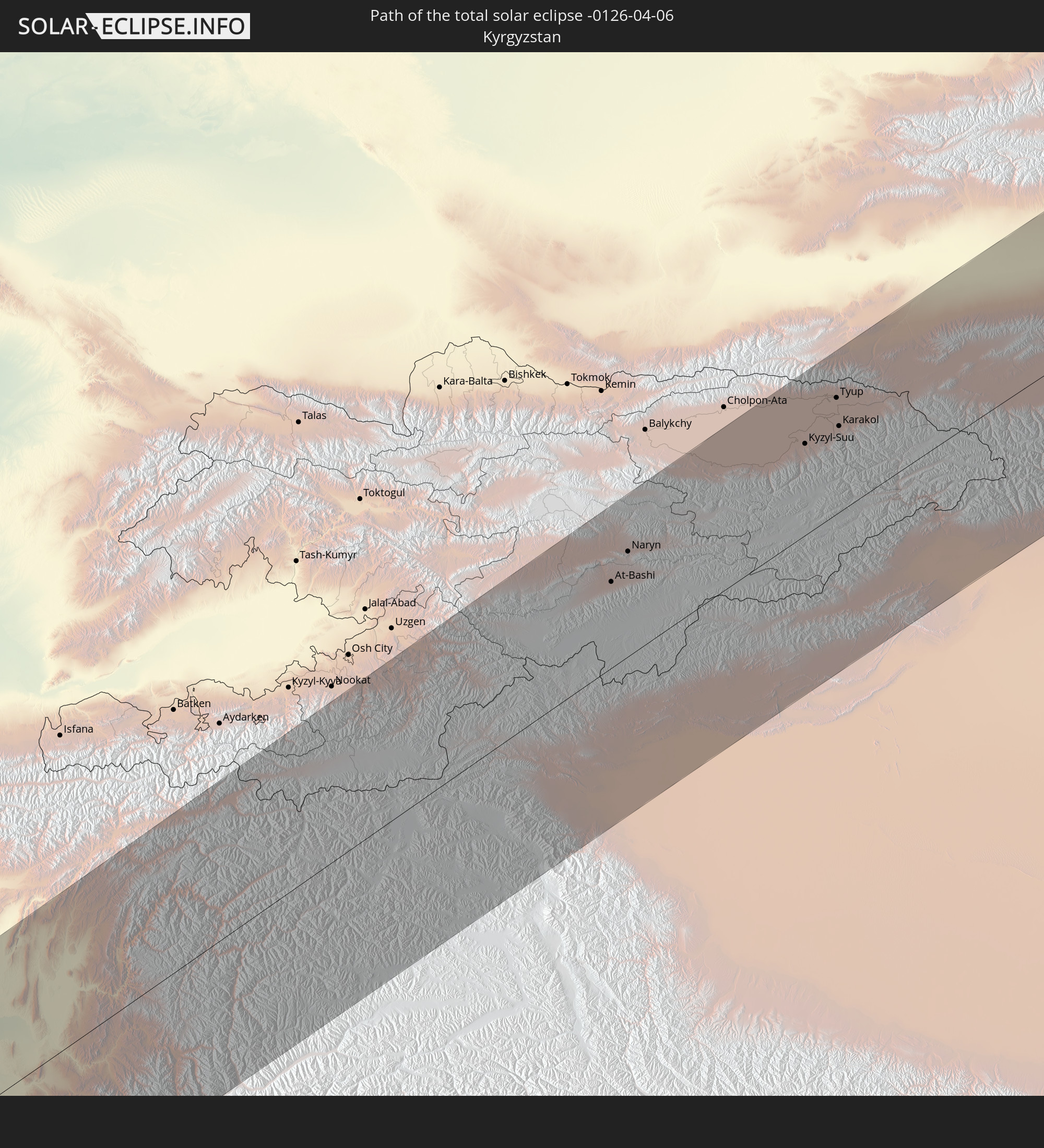 Kyrgyzstan
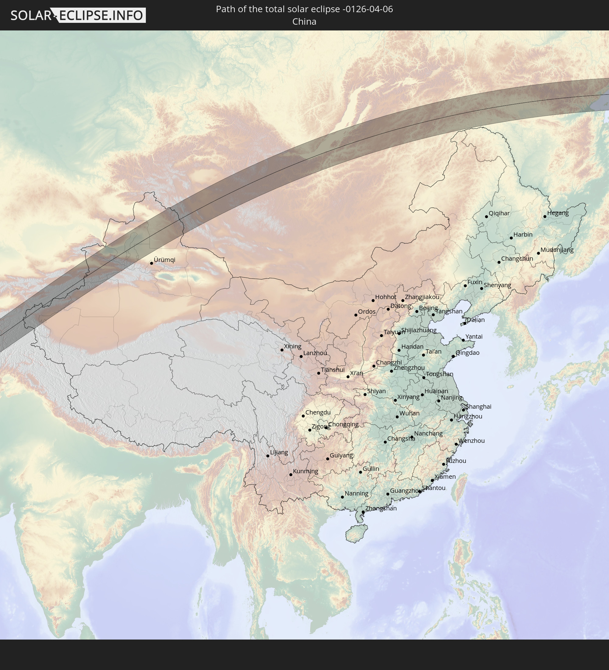 China
China
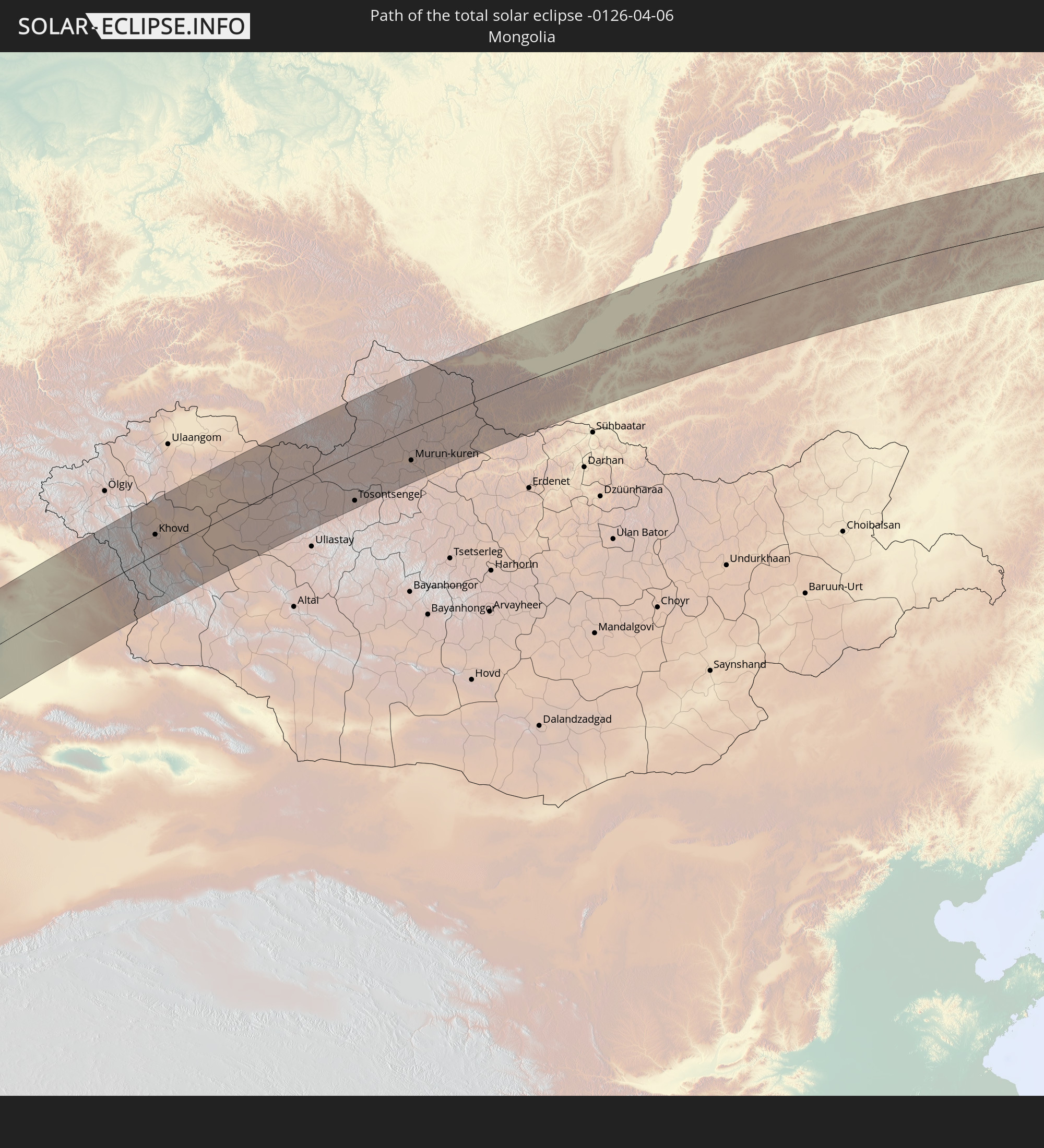 Mongolia
In den folgenden Ländern ist die Sonnenfinsternis partiell zu sehen
 Russia
 Greenland
 Svalbard and Jan Mayen
 United Kingdom
 France
 Belgium
 Netherlands
 Norway
 Luxembourg
 Germany
 Switzerland
 Italy
Italy
 Monaco
 Tunisia
 Denmark
 Libya
Libya
 Liechtenstein
 Austria
 Sweden
 Czechia
 Democratic Republic of the Congo
 San Marino
 Vatican City
 Slovenia
 Chad
Chad
 Croatia
 Poland
 Malta
Malta
 Central African Republic
 Bosnia and Herzegovina
 Hungary
 Slovakia
 Montenegro
 Serbia
 Albania
 Åland Islands
 Greece
 Romania
 Republic of Macedonia
 Finland
 Lithuania
 Latvia
 Estonia
 Sudan
Sudan
 Zambia
 Ukraine
 Bulgaria
 Belarus
 Egypt
Egypt
 Turkey
 Moldova
 Rwanda
 Burundi
 Tanzania
 Uganda
 Mozambique
 Cyprus
 Malawi
 Ethiopia
 Kenya
Kenya
 State of Palestine
 Israel
 Saudi Arabia
 Jordan
 Lebanon
 Syria
Syria
 Eritrea
 Iraq
Iraq
 Georgia
 Somalia
 Djibouti
 Yemen
Yemen
 Armenia
 Iran
Iran
 Azerbaijan
 Seychelles
 Kazakhstan
 Kuwait
 Bahrain
 Qatar
Qatar
 United Arab Emirates
 Oman
Oman
 Turkmenistan
 Uzbekistan
 Afghanistan
 Pakistan
 Tajikistan
 India
India
 Kyrgyzstan
 Maldives
 China
China
 Sri Lanka
 Nepal
Nepal
 Mongolia
 Bangladesh
 Bhutan
 Myanmar
 Thailand
 Laos
Laos
 Vietnam
 Macau
Macau
 Hong Kong
 Taiwan
 Japan
Japan
 North Korea
 South Korea
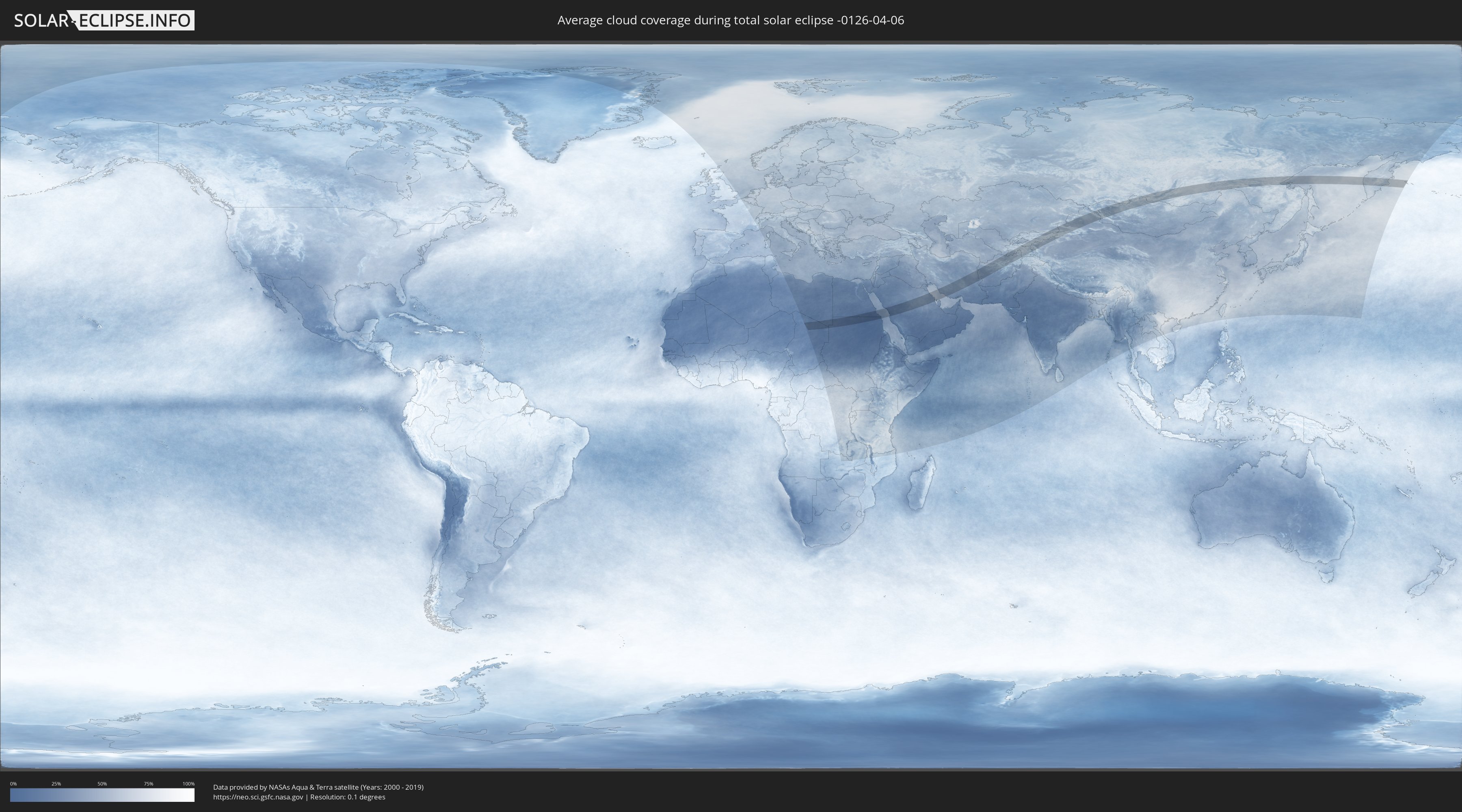
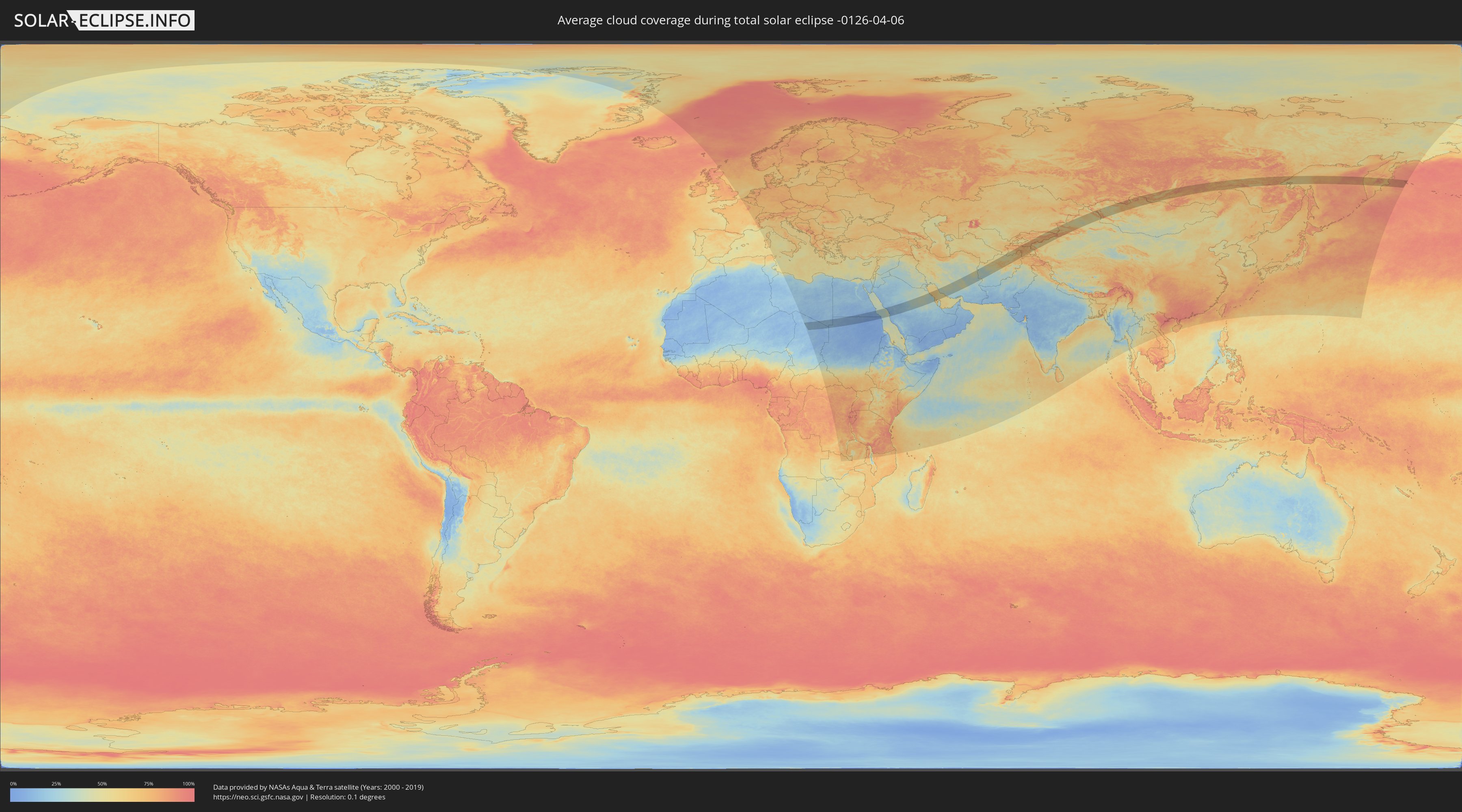
How will be the weather during the total solar eclipse on 04/06/-0126?
Where is the best place to see the total solar eclipse of 04/06/-0126?
The following maps show the average cloud coverage for the day of the total solar eclipse.
With the help of these maps, it is possible to find the place along the eclipse path, which has the best
chance of a cloudless sky.
Nevertheless, you should consider local circumstances and inform about the weather of your chosen
observation site.
The data is provided by NASAs satellites
AQUA and TERRA.
The cloud maps are averaged over a period of 19 years (2000 - 2019).
Detailed country maps
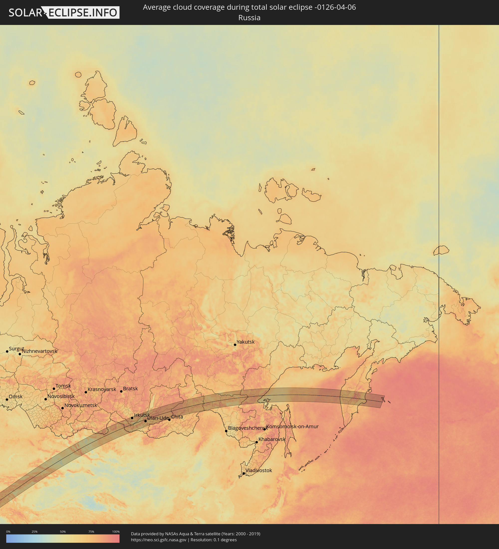 Russia
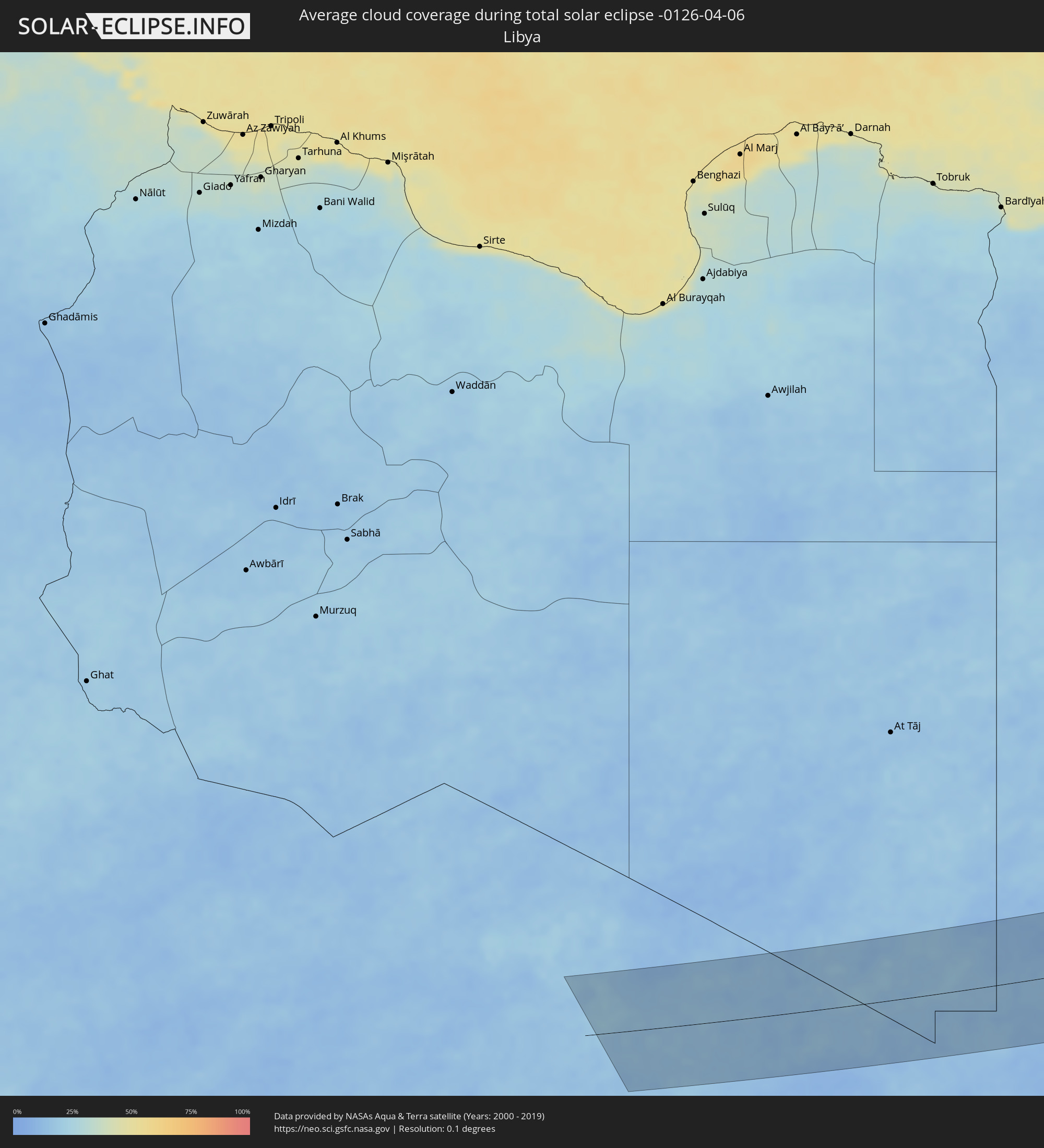 Libya
Libya
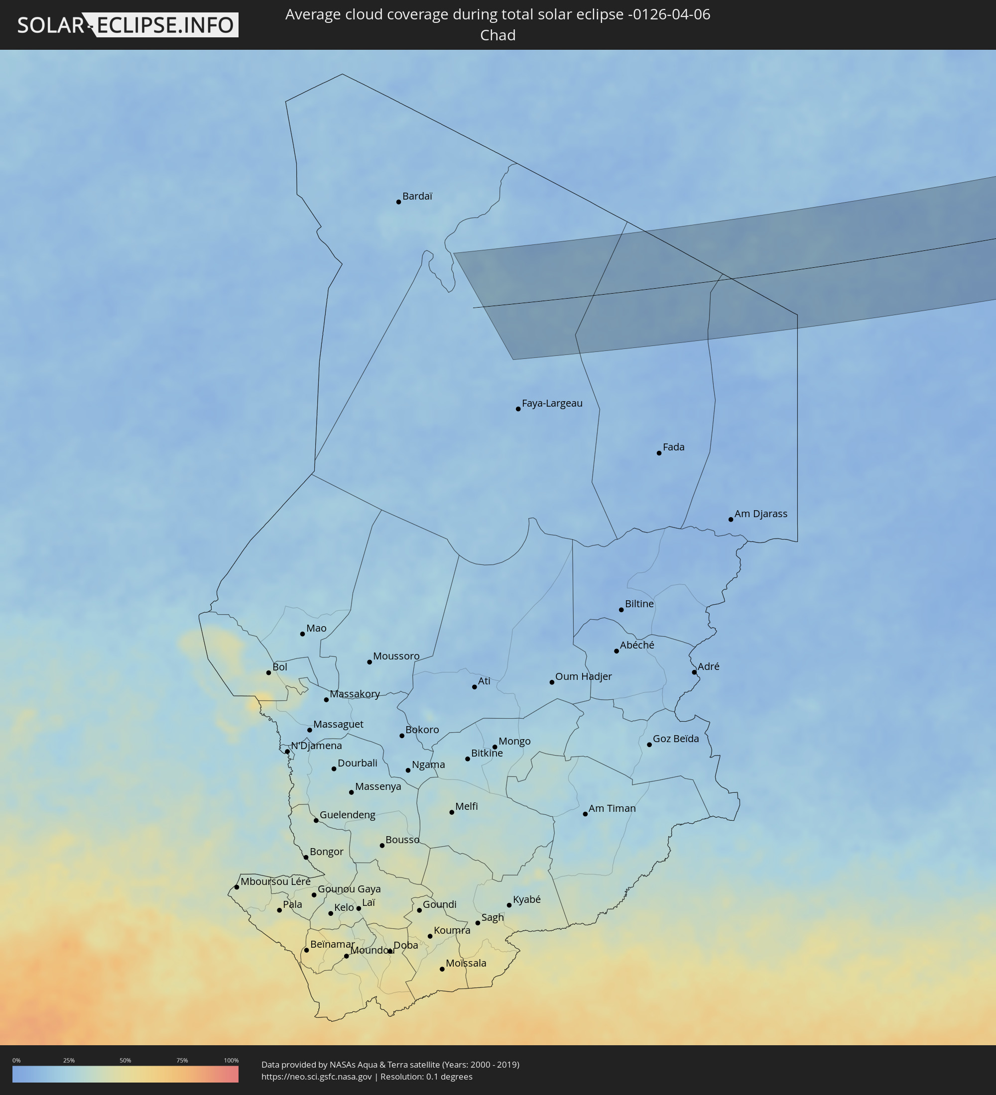 Chad
Chad
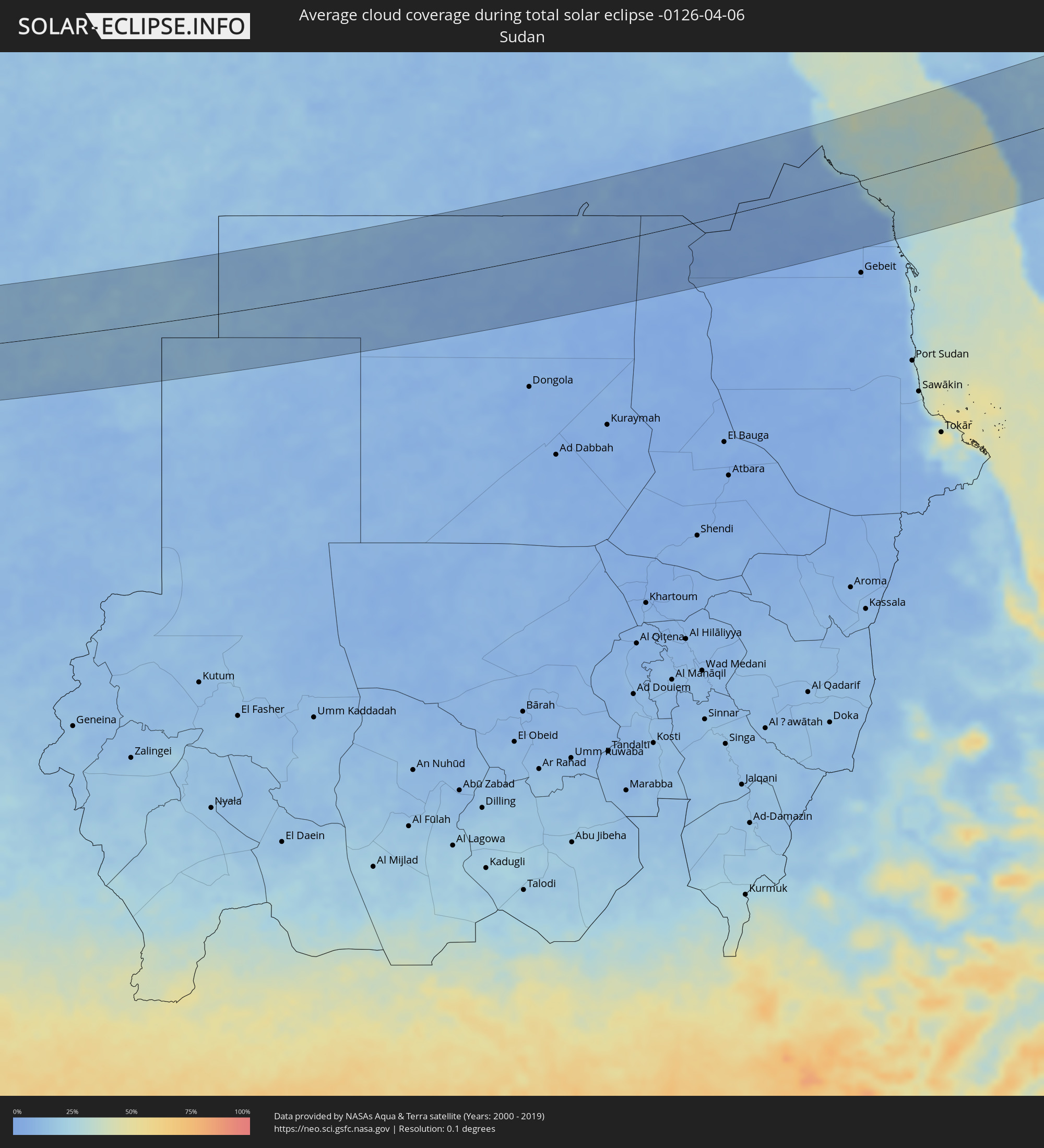 Sudan
Sudan
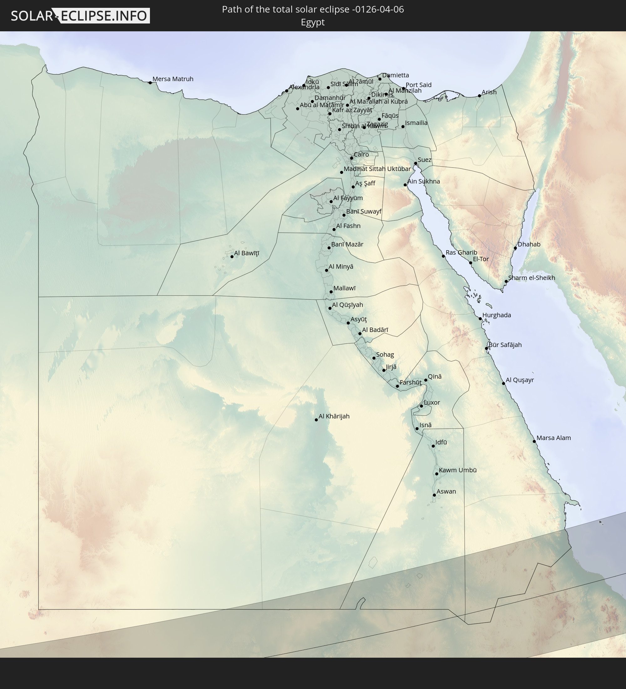
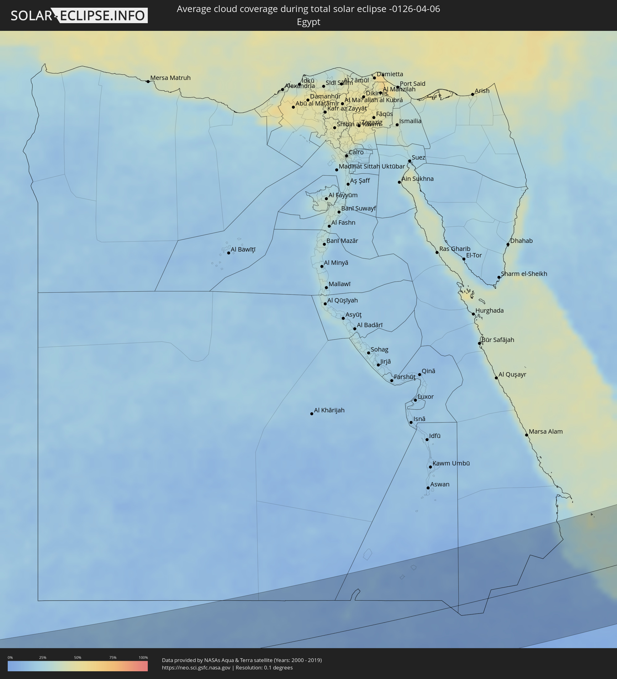 Egypt
Egypt
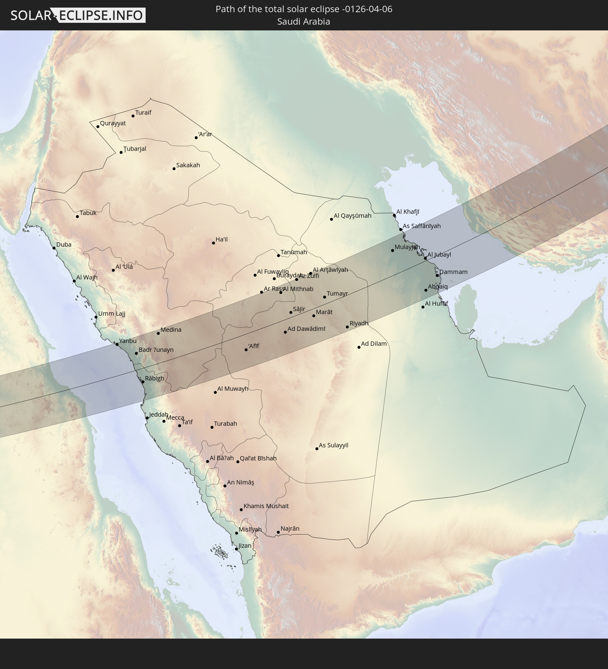
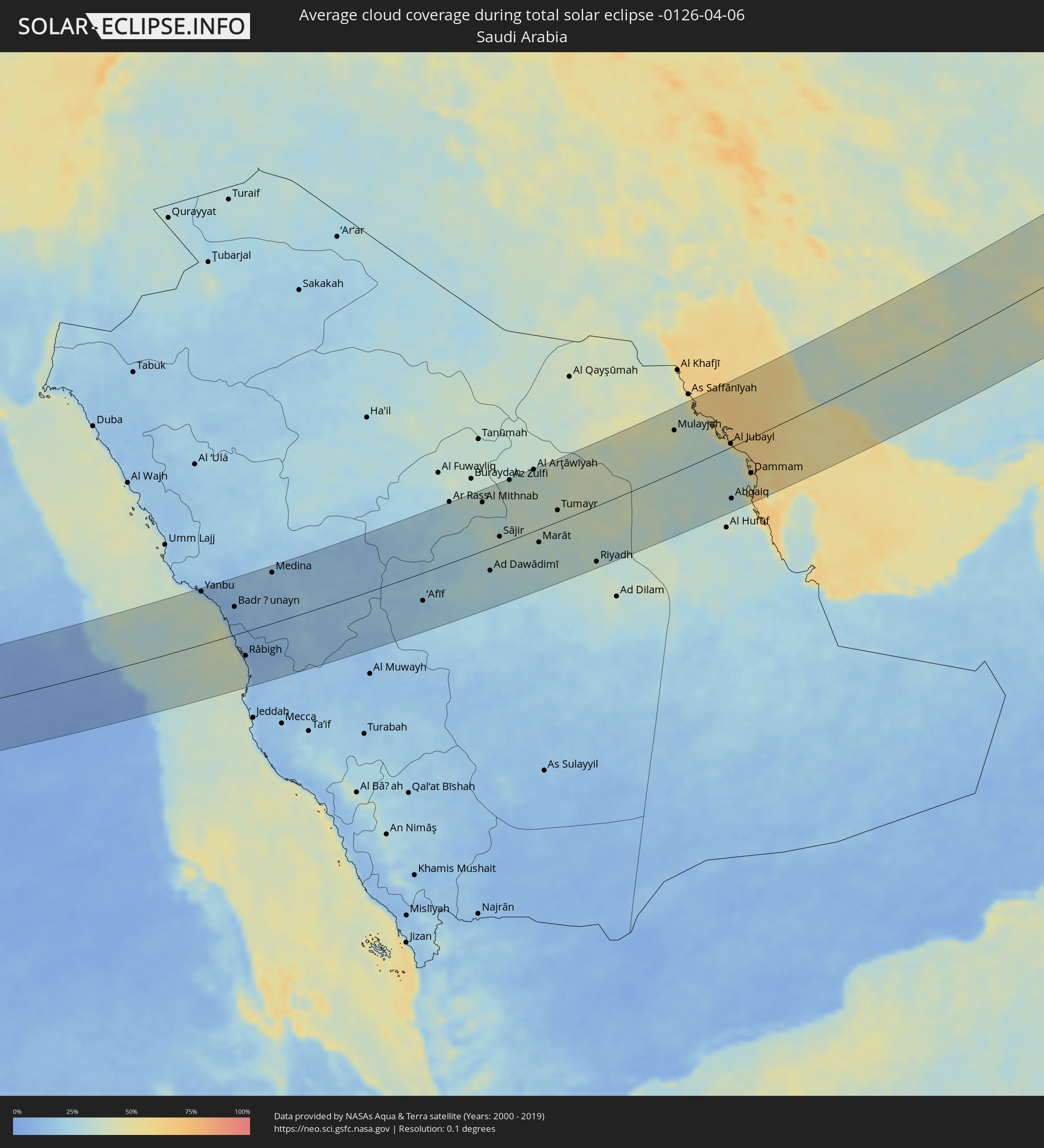 Saudi Arabia
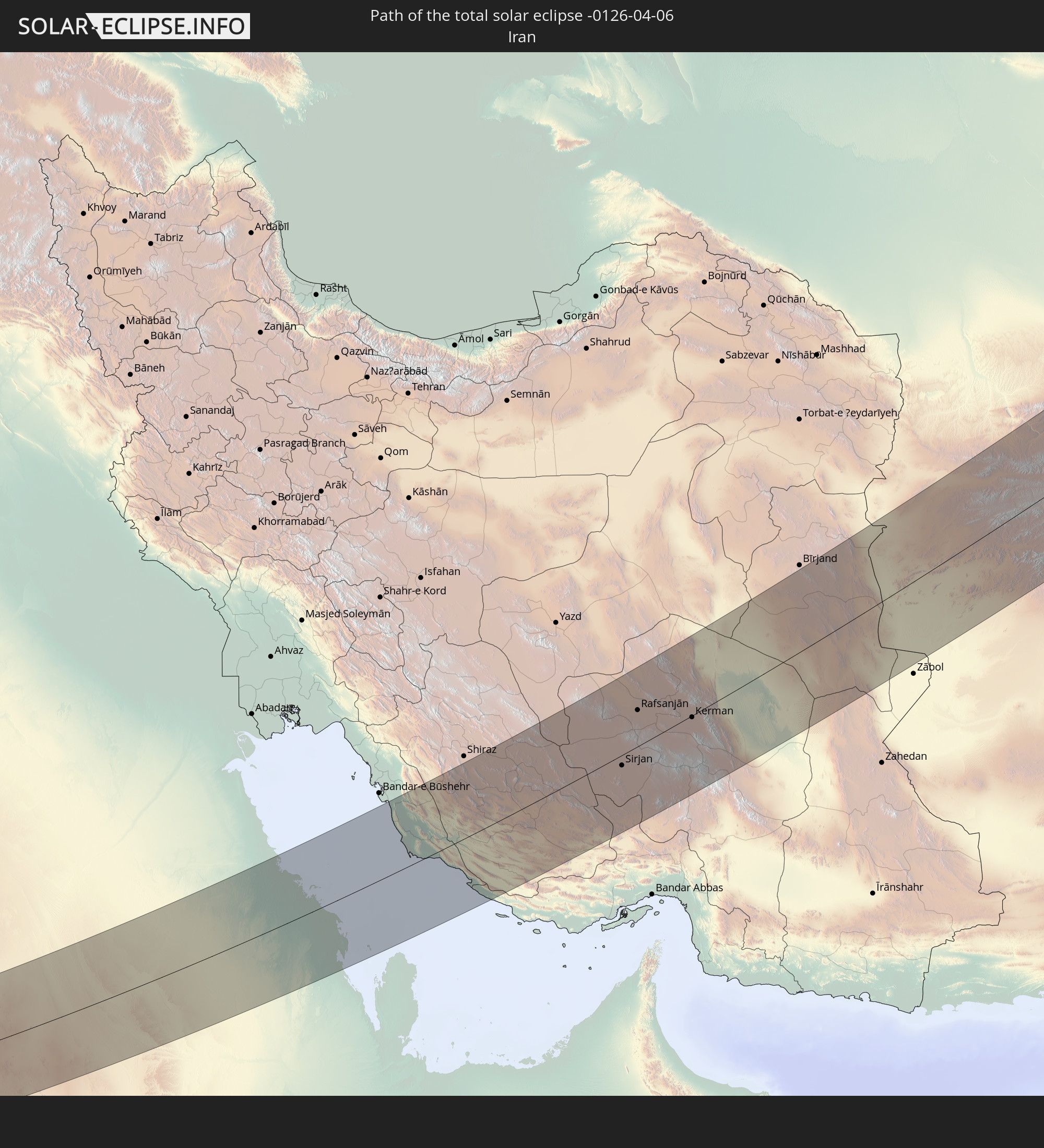
 Iran
Iran
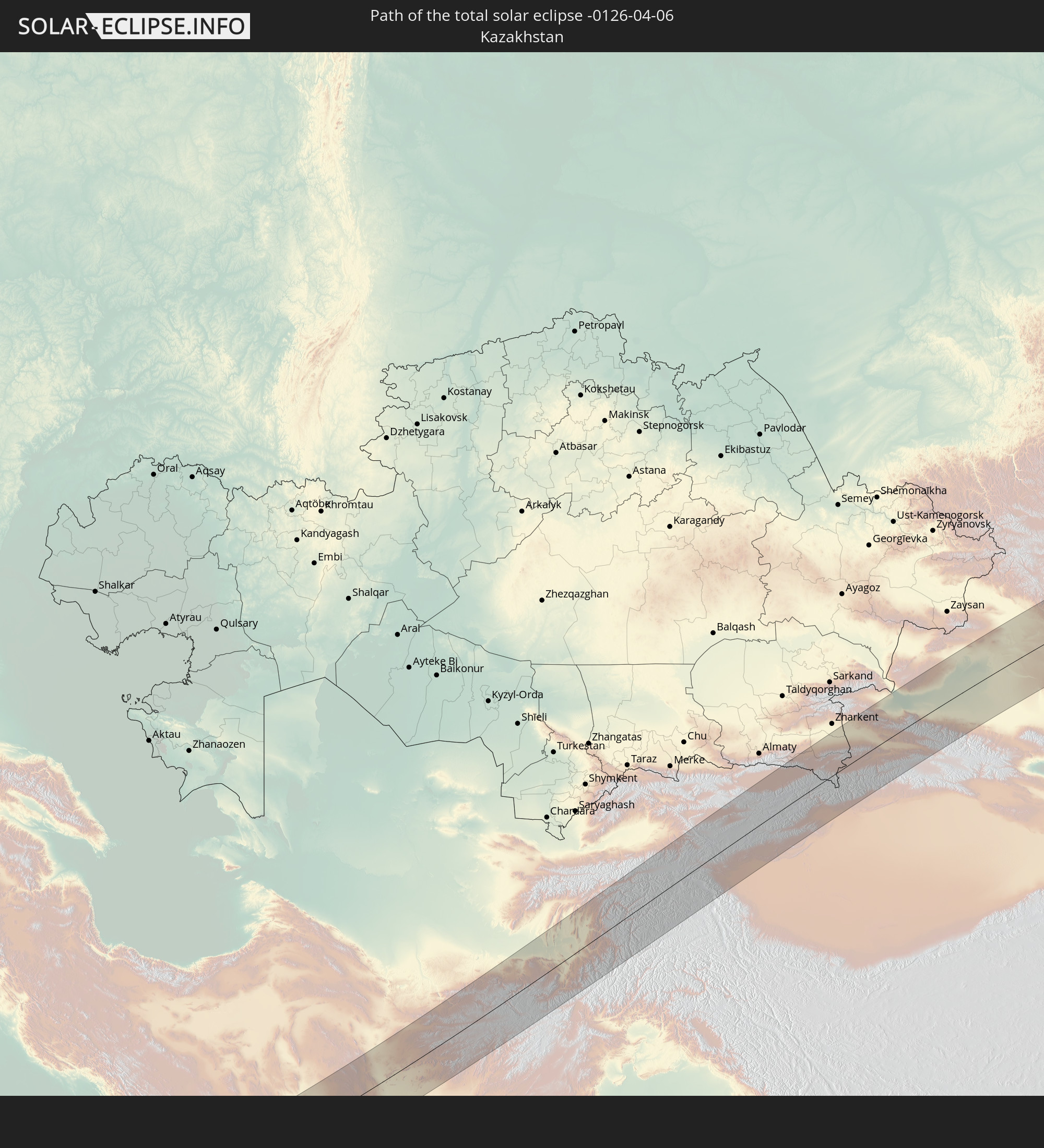
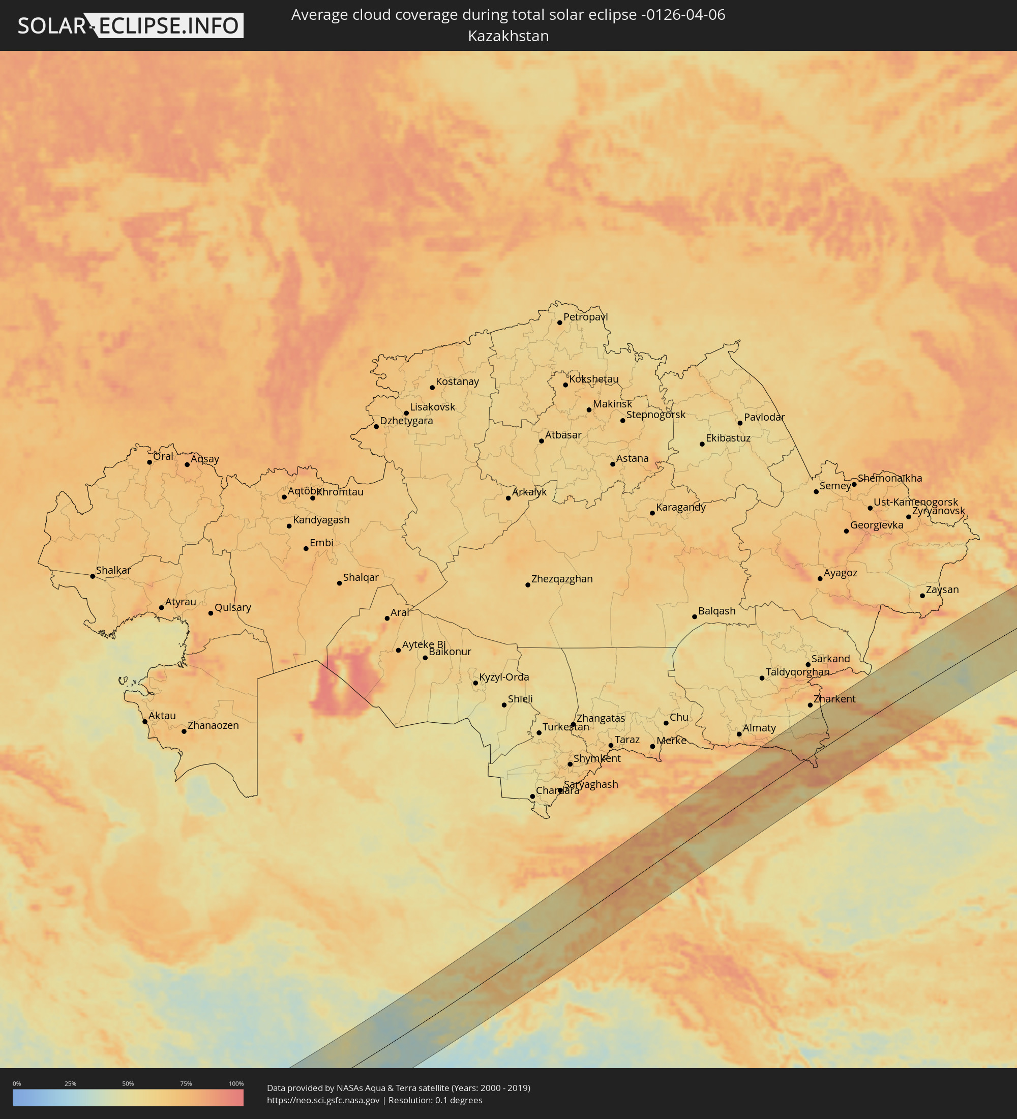 Kazakhstan
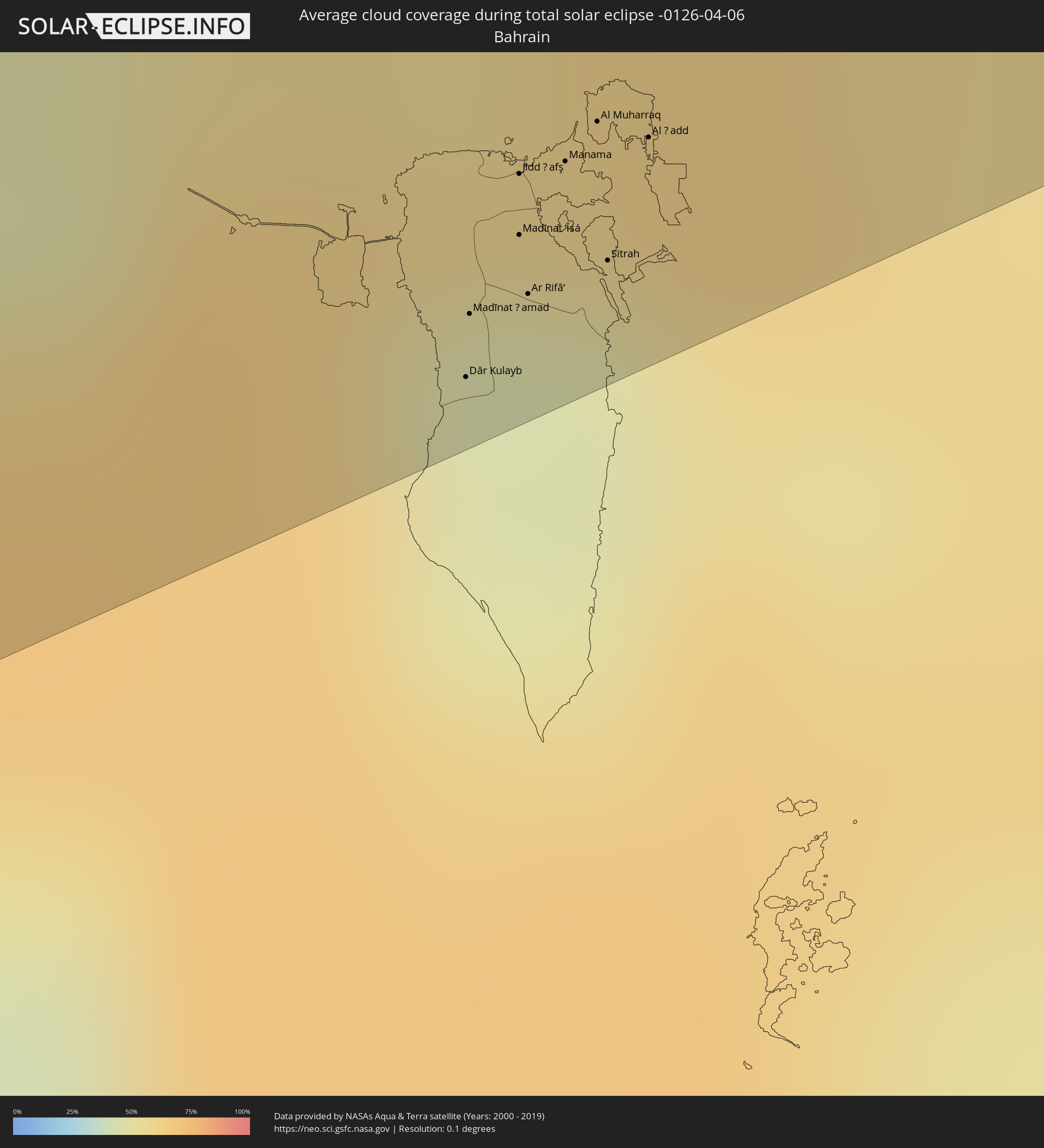 Bahrain
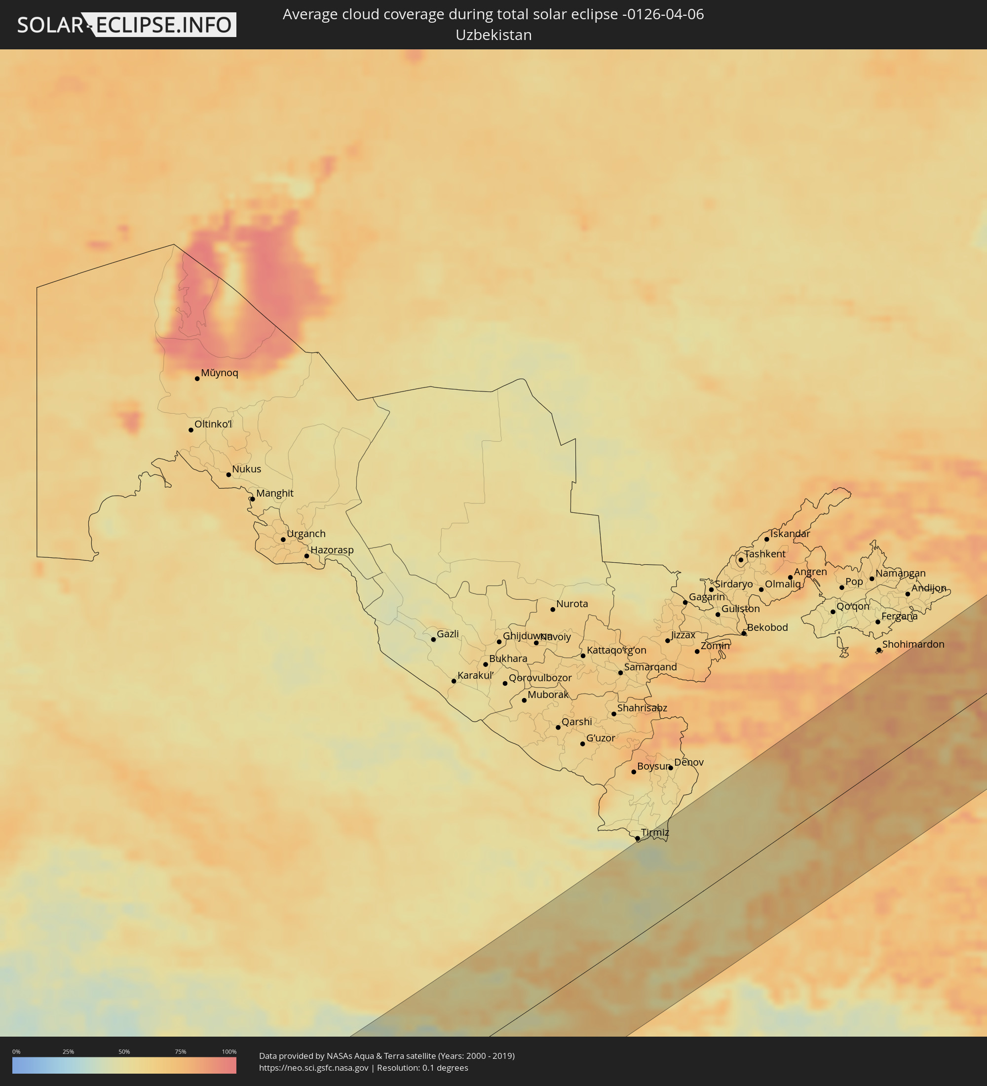 Uzbekistan
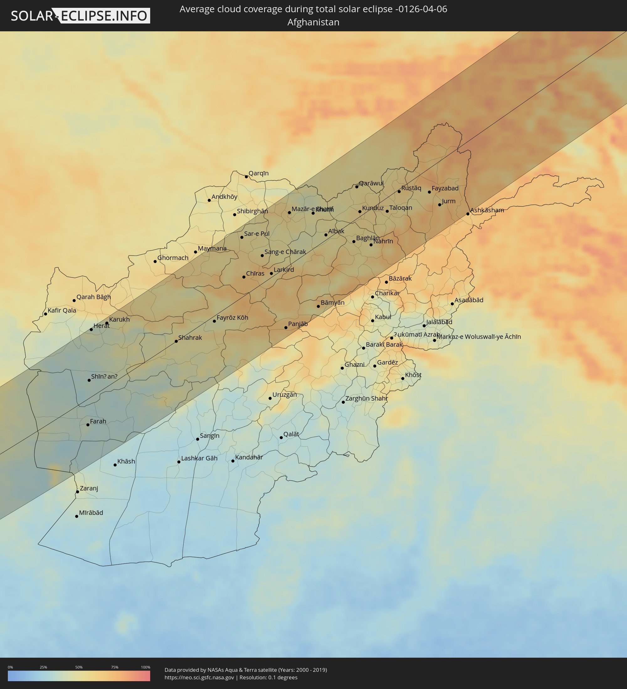 Afghanistan
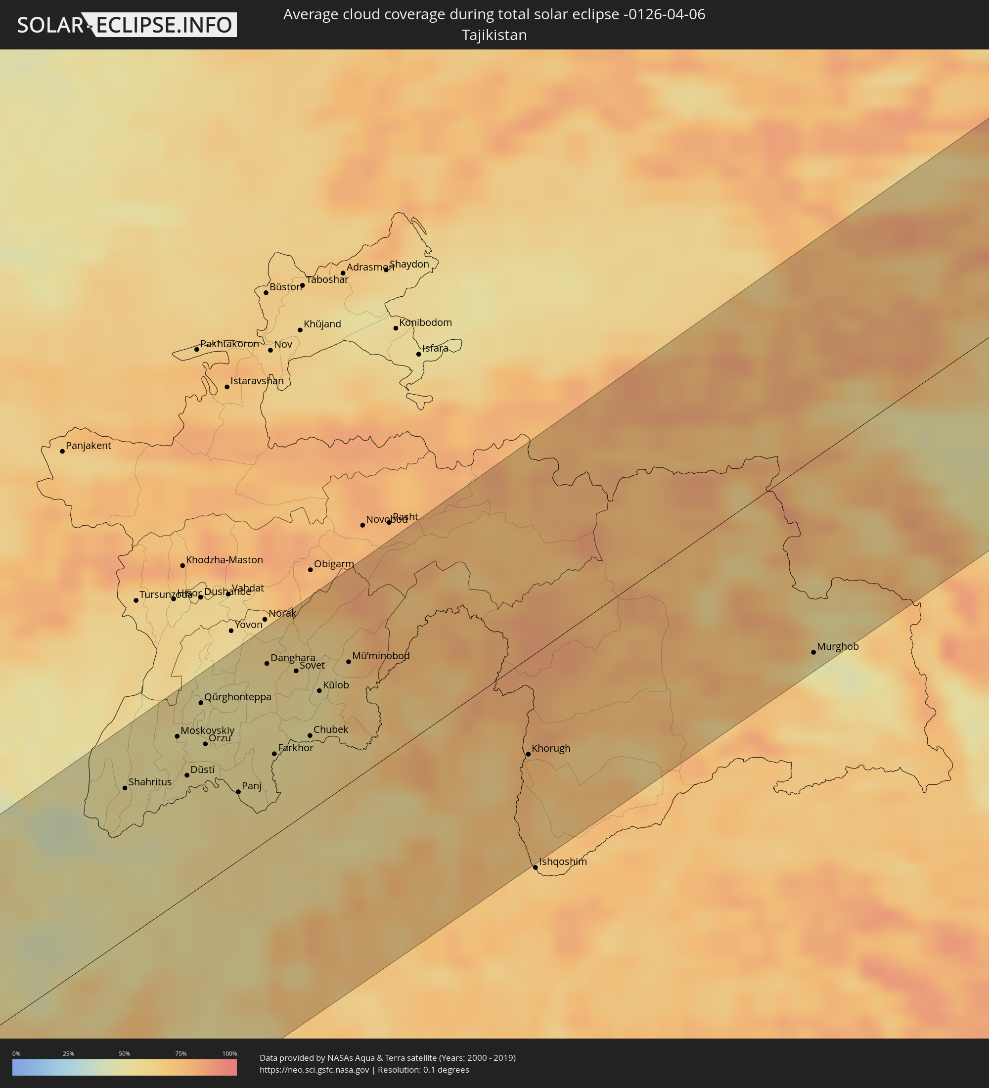 Tajikistan
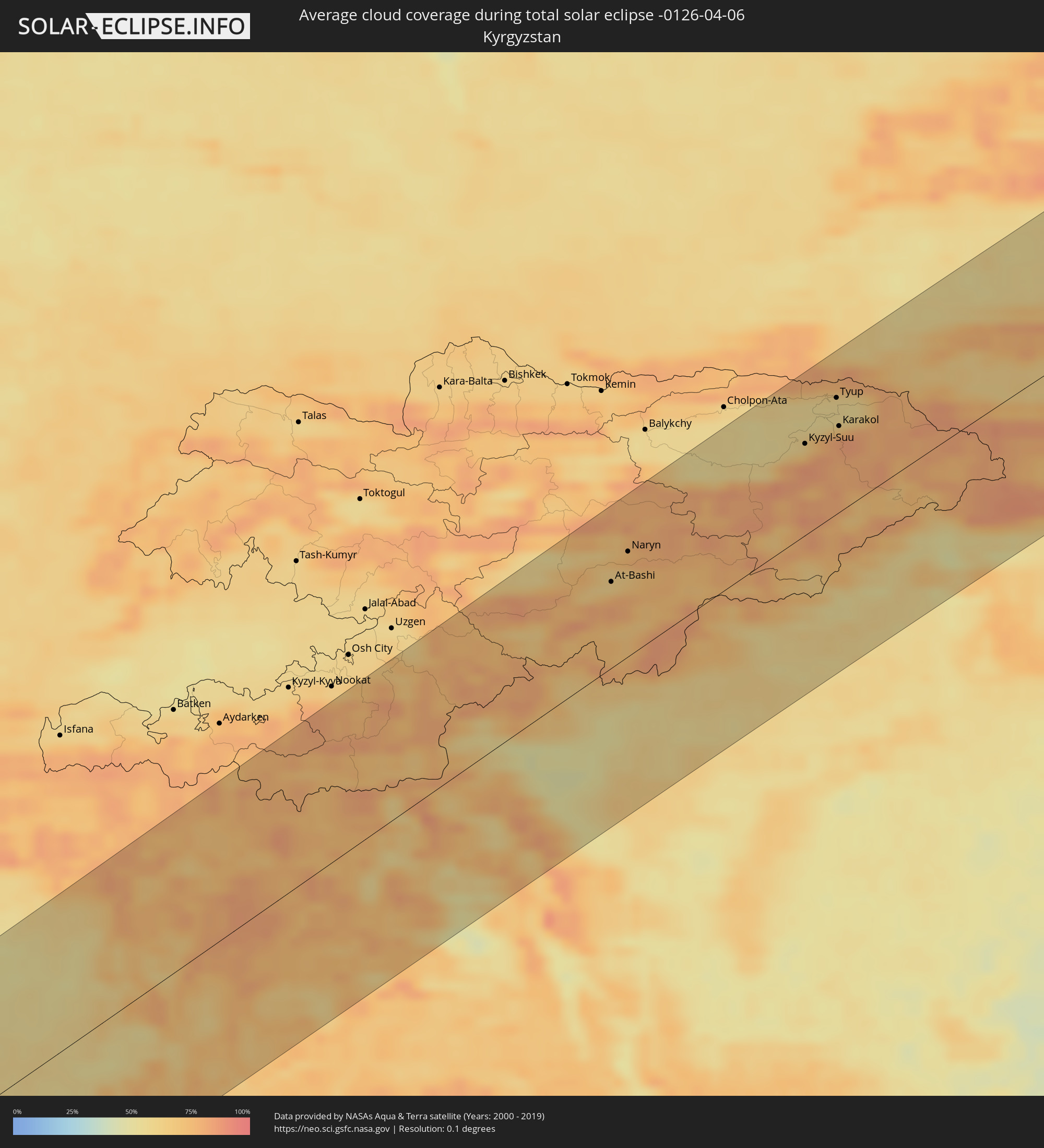 Kyrgyzstan
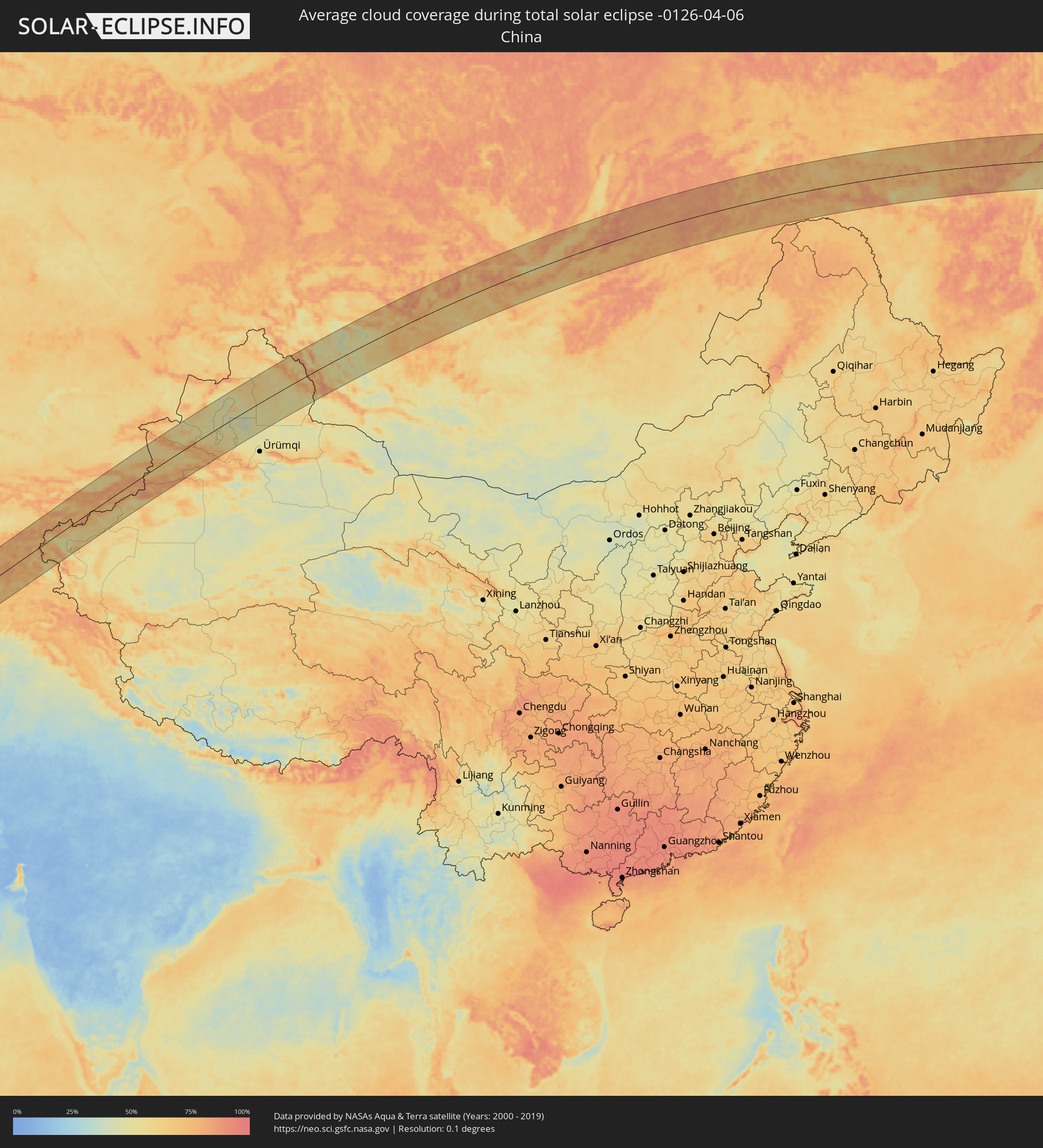 China
China
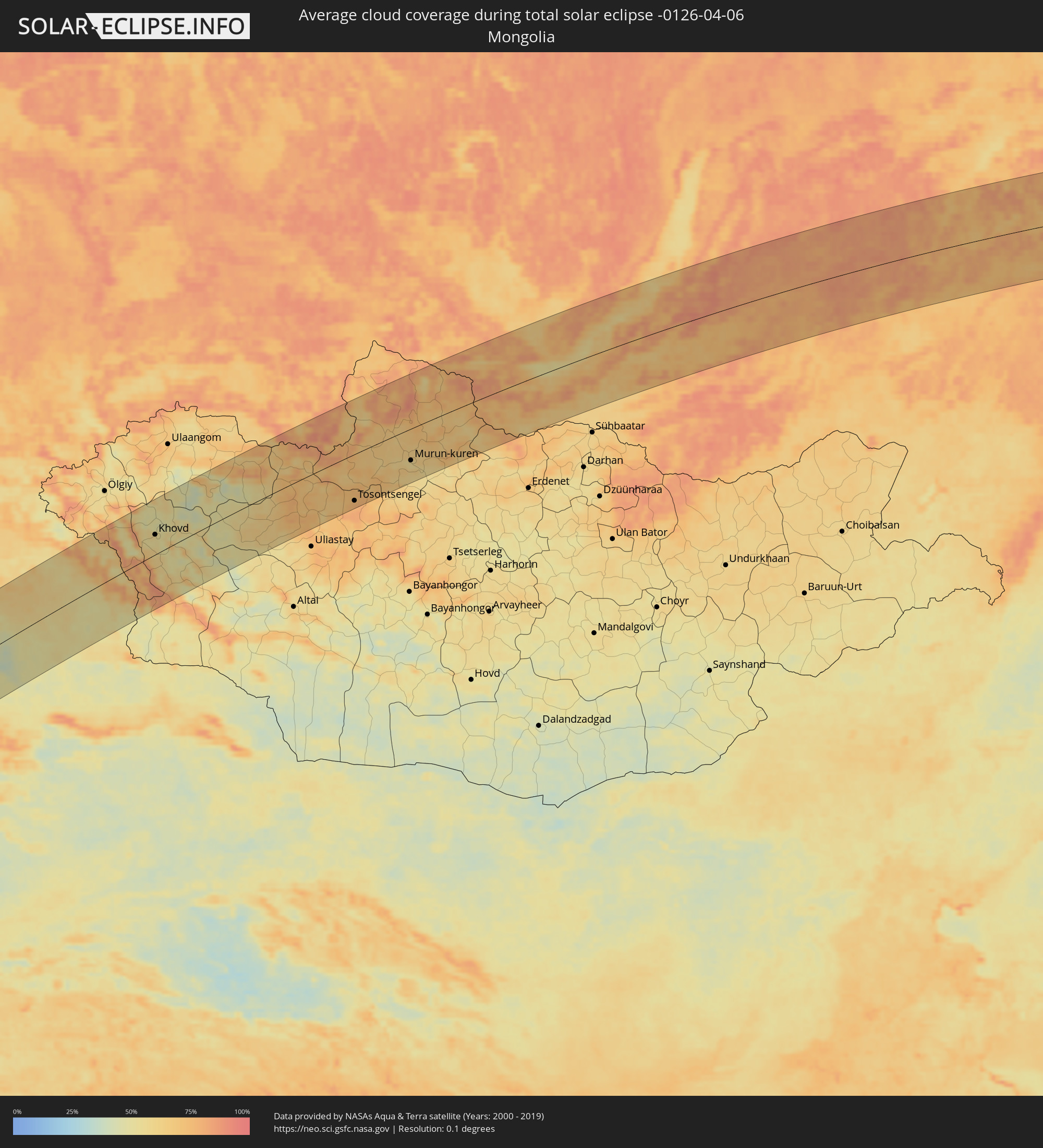 Mongolia
Cities inside the path of the eclipse
The following table shows all locations with a population of more than 5,000 inside the eclipse path. Cities which have more than 100,000 inhabitants are marked bold. A click at the locations opens a detailed map.
| City | Type | Eclipse duration | Local time of max. eclipse | Distance to central line | Ø Cloud coverage |
|
Yanbu, Al Madīnah al Munawwarah
|
total | - | 07:59:08 UTC+03:06 | 114 km | 23% |
|
Badr Ḩunayn, Al Madīnah al Munawwarah
|
total | - | 07:59:06 UTC+03:06 | 60 km | 12% |
|
Rābigh, Makkah
|
total | - | 07:57:49 UTC+03:06 | 52 km | 22% |
|
Medina, Al Madīnah al Munawwarah
|
total | - | 08:00:35 UTC+03:06 | 108 km | 16% |
|
‘Afīf, Ar Riyāḑ
|
total | - | 08:01:57 UTC+03:06 | 59 km | 20% |
|
Al Mithnab, Al-Qassim
|
total | - | 08:05:56 UTC+03:06 | 100 km | 35% |
|
Ad Dawādimī, Ar Riyāḑ
|
total | - | 08:03:59 UTC+03:06 | 47 km | 28% |
|
Sājir, Ar Riyāḑ
|
total | - | 08:05:11 UTC+03:06 | 16 km | 34% |
|
Az Zulfi, Ar Riyāḑ
|
total | - | 08:07:06 UTC+03:06 | 124 km | 35% |
|
Riyadh, Ar Riyāḑ
|
total | - | 08:06:12 UTC+03:06 | 114 km | 36% |
|
Al Jubayl, Eastern Province
|
total | - | 08:12:40 UTC+03:06 | 7 km | 45% |
|
Abqaiq, Eastern Province
|
total | - | 08:10:57 UTC+03:06 | 103 km | 30% |
|
Umm as Sāhik, Eastern Province
|
total | - | 08:12:21 UTC+03:06 | 40 km | 35% |
|
Al Awjām, Eastern Province
|
total | - | 08:12:14 UTC+03:06 | 50 km | 33% |
|
Şafwá, Eastern Province
|
total | - | 08:12:23 UTC+03:06 | 42 km | 44% |
|
Tārūt, Eastern Province
|
total | - | 08:12:21 UTC+03:06 | 53 km | 44% |
|
Sayhāt, Eastern Province
|
total | - | 08:12:12 UTC+03:06 | 62 km | 35% |
|
Raḩīmah, Eastern Province
|
total | - | 08:12:35 UTC+03:06 | 40 km | 59% |
|
Dammam, Eastern Province
|
total | - | 08:12:11 UTC+03:06 | 70 km | 37% |
|
Khobar, Eastern Province
|
total | - | 08:12:03 UTC+03:06 | 90 km | 47% |
|
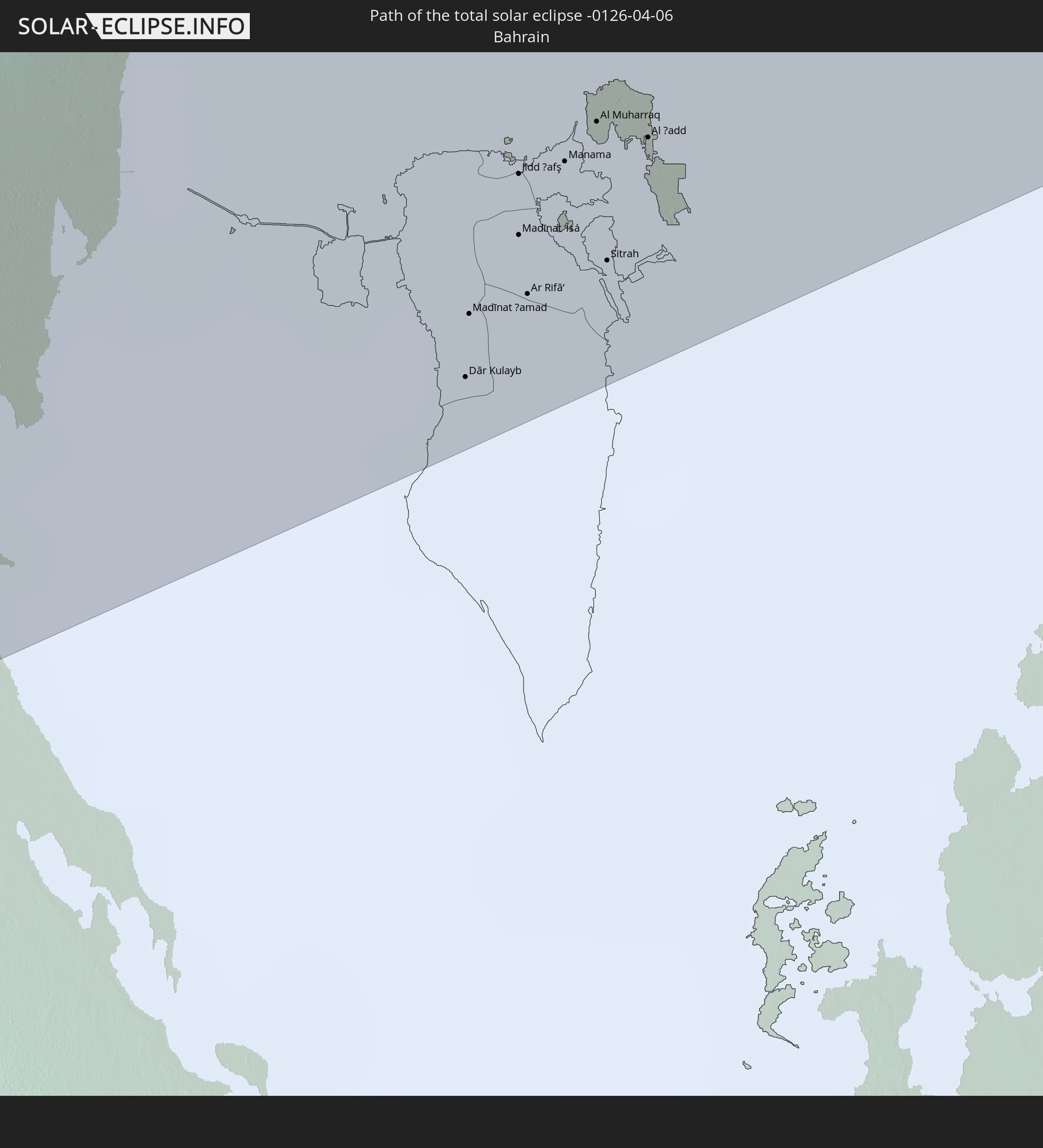
Dār Kulayb, Southern Governorate
|
total | - | 08:31:16 UTC+03:26 | 124 km | 46% |
|
Madīnat Ḩamad, Central Governorate
|
total | - | 08:31:21 UTC+03:26 | 119 km | 46% |
|
Madīnat ‘Īsá, Southern Governorate
|
total | - | 08:31:29 UTC+03:26 | 115 km | 46% |
|
Jidd Ḩafş, Manama
|
total | - | 08:31:34 UTC+03:26 | 110 km | 46% |
|
Ar Rifā‘, Southern Governorate
|
total | - | 08:31:26 UTC+03:26 | 119 km | 44% |
|
Manama, Manama
|
total | - | 08:31:37 UTC+03:26 | 111 km | 46% |
|
Al Muharraq, Muharraq
|
total | - | 08:31:41 UTC+03:26 | 109 km | 58% |
|
Sitrah, Manama
|
total | - | 08:31:32 UTC+03:26 | 120 km | 46% |
|
Al Ḩadd, Muharraq
|
total | - | 08:31:43 UTC+03:26 | 112 km | 55% |
|
Fīrūzābād, Fars
|
total | - | 08:37:41 UTC+03:25 | 65 km | 43% |
|
Akbarābād, Fars
|
total | - | 08:38:36 UTC+03:25 | 96 km | 40% |
|
Fasā, Fars
|
total | - | 08:39:05 UTC+03:25 | 26 km | 38% |
|
Gerāsh, Fars
|
total | - | 08:37:32 UTC+03:25 | 122 km | 33% |
|
Neyrīz, Fars
|
total | - | 08:40:20 UTC+03:25 | 21 km | 41% |
|
Dārāb, Fars
|
total | - | 08:39:51 UTC+03:25 | 33 km | 35% |
|
Shahr-e Bābak, Kerman
|
total | - | 08:42:51 UTC+03:25 | 74 km | 38% |
|
Sirjan, Kerman
|
total | - | 08:42:25 UTC+03:25 | 17 km | 36% |
|
Rafsanjān, Kerman
|
total | - | 08:44:26 UTC+03:25 | 61 km | 40% |
|
Shahrak-e Pābedānā, Kerman
|
total | - | 08:46:11 UTC+03:25 | 112 km | 38% |
|
Zarand, Kerman
|
total | - | 08:45:51 UTC+03:25 | 73 km | 42% |
|
Bardsīr, Kerman
|
total | - | 08:44:21 UTC+03:25 | 14 km | 44% |
|
Rāvar, Kerman
|
total | - | 08:46:56 UTC+03:25 | 105 km | 38% |
|
Kerman, Kerman
|
total | - | 08:45:37 UTC+03:25 | 3 km | 41% |
|
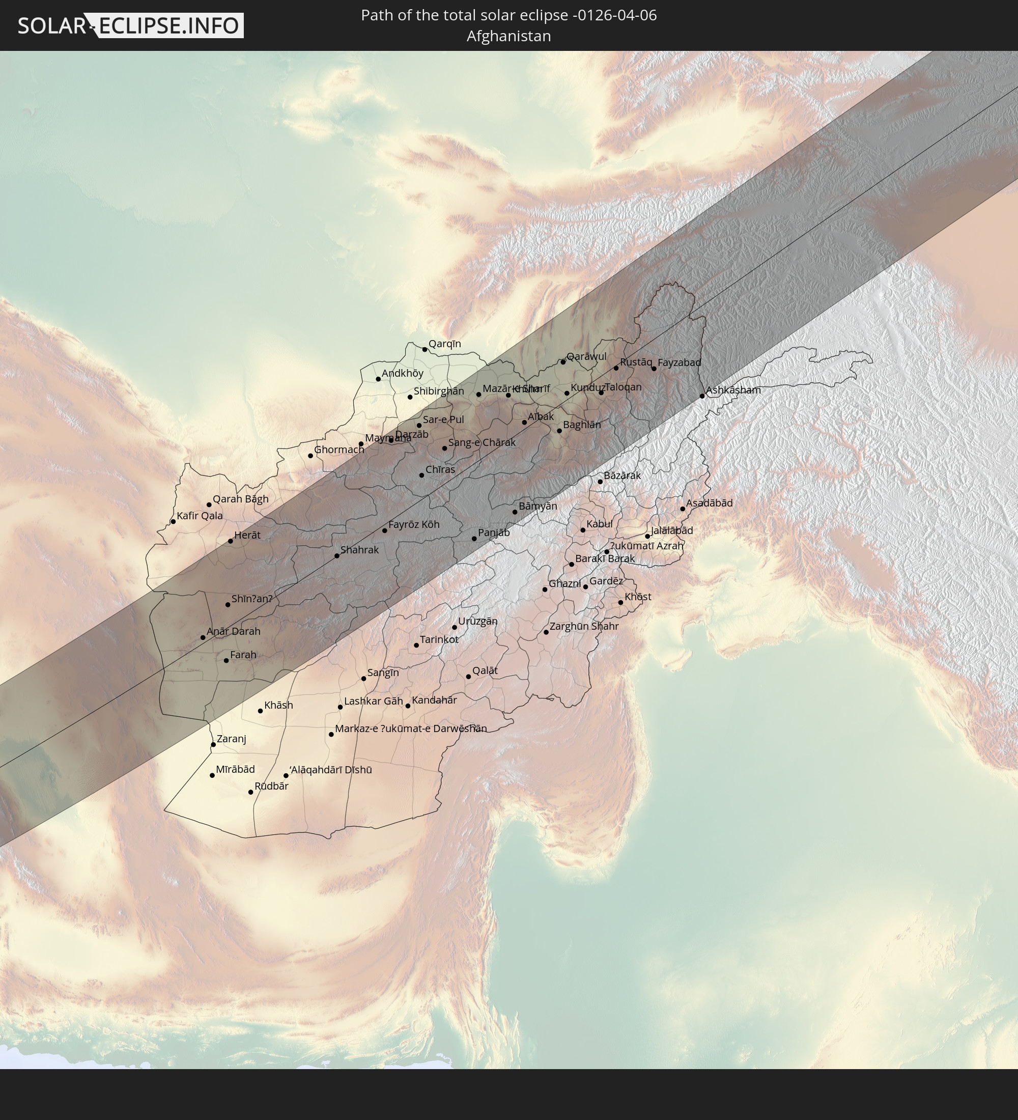
Farah, Farah
|
total | - | 09:30:29 UTC+04:00 | 52 km | 36% |
|
Shīnḏanḏ, Herat
|
total | - | 09:32:06 UTC+04:00 | 34 km | 34% |
|
Herāt, Herat
|
total | - | 09:33:56 UTC+04:00 | 128 km | 43% |
|
Karukh, Herat
|
total | - | 09:34:44 UTC+04:00 | 121 km | 39% |
|
Sar-e Pul, Sar-e Pol
|
total | - | 09:42:42 UTC+04:00 | 110 km | 55% |
|
Balkh, Balkh
|
total | - | 09:45:06 UTC+04:00 | 110 km | 63% |
|
Mazār-e Sharīf, Balkh
|
total | - | 09:45:22 UTC+04:00 | 95 km | 57% |
|
Khulm, Balkh
|
total | - | 09:46:17 UTC+04:00 | 64 km | 48% |
|
Bāmyān, Bamyan
|
total | - | 09:43:30 UTC+04:00 | 115 km | 53% |
|
Aībak, Samangan
|
total | - | 09:46:07 UTC+04:00 | 8 km | 49% |
|
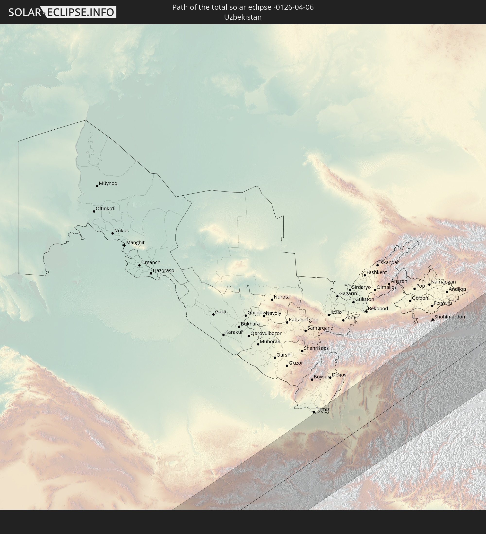
Shahritus, Khatlon
|
total | - | 10:23:05 UTC+04:35 | 93 km | 53% |
|
Gharavŭtí, Khatlon
|
total | - | 10:24:04 UTC+04:35 | 105 km | 52% |
|
Moskovskiy, Khatlon
|
total | - | 10:24:21 UTC+04:35 | 102 km | 51% |
|
Kolkhozobod, Khatlon
|
total | - | 10:24:26 UTC+04:35 | 96 km | 51% |
|
Dŭstí, Khatlon
|
total | - | 10:24:05 UTC+04:35 | 74 km | 53% |
|
Baghlān, Baghlan
|
total | - | 09:47:03 UTC+04:00 | 39 km | 55% |
|
Pul-e Khumrī, Baghlan
|
total | - | 09:46:46 UTC+04:00 | 57 km | 57% |
|
Qarāwul, Kunduz
|
total | - | 09:48:52 UTC+04:00 | 56 km | 54% |
|
Qŭrghonteppa, Khatlon
|
total | - | 10:25:01 UTC+04:35 | 112 km | 51% |
|
Abdurahmoni Jomí, Khatlon
|
total | - | 10:25:14 UTC+04:35 | 121 km | 49% |
|
Orzu, Khatlon
|
total | - | 10:24:39 UTC+04:35 | 85 km | 51% |
|
Vakhsh, Khatlon
|
total | - | 10:24:55 UTC+04:35 | 99 km | 51% |
|
Kunduz, Kunduz
|
total | - | 09:48:14 UTC+04:00 | 8 km | 58% |
|
Kirov, Khatlon
|
total | - | 10:25:07 UTC+04:35 | 107 km | 51% |
|
Panj, Khatlon
|
total | - | 10:24:37 UTC+04:35 | 42 km | 55% |
|
Khanabad, Kunduz
|
total | - | 09:48:35 UTC+04:00 | 10 km | 57% |
|
Nahrīn, Baghlan
|
total | - | 09:47:39 UTC+04:00 | 67 km | 51% |
|
Danghara, Khatlon
|
total | - | 10:26:20 UTC+04:35 | 108 km | 54% |
|
Farkhor, Khatlon
|
total | - | 10:25:31 UTC+04:35 | 50 km | 53% |
|
Ārt Khwājah, Takhar
|
total | - | 09:49:49 UTC+04:00 | 9 km | 57% |
|
Taloqan, Takhar
|
total | - | 09:49:22 UTC+04:00 | 26 km | 54% |
|
Sovet, Khatlon
|
total | - | 10:26:40 UTC+04:35 | 91 km | 56% |
|
Vose’, Khatlon
|
total | - | 10:26:23 UTC+04:35 | 66 km | 52% |
|
Chubek, Khatlon
|
total | - | 10:26:12 UTC+04:35 | 46 km | 53% |
|
Kŭlob, Khatlon
|
total | - | 10:26:47 UTC+04:35 | 69 km | 55% |
|
Rustāq, Takhar
|
total | - | 09:50:27 UTC+04:00 | 5 km | 58% |
|
Mŭ’minobod, Khatlon
|
total | - | 10:27:29 UTC+04:35 | 74 km | 61% |
|
Fayzabad, Badakhshan
|
total | - | 09:51:42 UTC+04:00 | 44 km | 60% |
|
Khorugh, Gorno-Badakhshan
|
total | - | 10:29:06 UTC+04:35 | 59 km | 75% |
|
Murghob, Gorno-Badakhshan
|
total | - | 10:34:15 UTC+04:35 | 117 km | 48% |
|
At-Bashi, Naryn
|
total | - | 11:04:39 UTC+04:58 | 68 km | 63% |
|
Kashgar, Xinjiang Uyghur Autonomous Region
|
total | - | 14:04:22 UTC+08:00 | 97 km | 64% |
|
Naryn, Naryn
|
total | - | 11:05:18 UTC+04:58 | 82 km | 75% |
|
Kyzyl-Suu, Issyk-Kul Region
|
total | - | 11:09:50 UTC+04:58 | 71 km | 72% |
|
Tyup, Issyk-Kul Region
|
total | - | 11:10:53 UTC+04:58 | 90 km | 56% |
|
Karakol, Issyk-Kul Region
|
total | - | 11:10:39 UTC+04:58 | 67 km | 71% |
|
Ak-Suu, Issyk-Kul Region
|
total | - | 11:10:53 UTC+04:58 | 62 km | 76% |
|
Kegen, Almaty Oblysy
|
total | - | 10:36:07 UTC+04:21 | 78 km | 66% |
|
Baijiantan, Xinjiang Uyghur Autonomous Region
|
total | - | 14:26:35 UTC+08:00 | 71 km | 48% |
|
Hoxtolgay, Xinjiang Uyghur Autonomous Region
|
total | - | 14:28:38 UTC+08:00 | 114 km | 52% |
|
Shihezi, Xinjiang Uyghur Autonomous Region
|
total | - | 14:26:58 UTC+08:00 | 98 km | 50% |
|
Khovd, Hovd
|
total | - | 12:44:53 UTC+06:06 | 44 km | 55% |
|
Tosontsengel, Dzabkhan
|
total | - | 12:54:55 UTC+06:06 | 102 km | 75% |
|
Murun-kuren, Hövsgöl
|
total | - | 13:58:33 UTC+07:07 | 69 km | 55% |
|
Zakamensk, Respublika Buryatiya
|
total | - | 13:52:14 UTC+06:57 | 80 km | 74% |
|
Slyudyanka, Irkutsk
|
total | - | 13:52:36 UTC+06:57 | 42 km | 74% |
|
Meget, Irkutsk
|
total | - | 13:52:53 UTC+06:57 | 112 km | 66% |
|
Shelekhov, Irkutsk
|
total | - | 13:52:59 UTC+06:57 | 90 km | 69% |
|
Baykal’sk, Irkutsk
|
total | - | 13:53:09 UTC+06:57 | 16 km | 70% |
|
Irkutsk, Irkutsk
|
total | - | 13:53:12 UTC+06:57 | 93 km | 64% |
|
Petropavlovka, Respublika Buryatiya
|
total | - | 13:54:48 UTC+06:57 | 107 km | 68% |
|
Gusinoozyorsk, Respublika Buryatiya
|
total | - | 13:56:06 UTC+06:57 | 66 km | 68% |
|
Kabansk, Respublika Buryatiya
|
total | - | 13:56:04 UTC+06:57 | 10 km | 73% |
|
Ivolginsk, Respublika Buryatiya
|
total | - | 13:56:54 UTC+06:57 | 36 km | 69% |
|
Zarechnyy, Respublika Buryatiya
|
total | - | 13:57:09 UTC+06:57 | 31 km | 66% |
|
Ulan-Ude, Respublika Buryatiya
|
total | - | 13:57:15 UTC+06:57 | 35 km | 66% |
|
Turuntayevo, Respublika Buryatiya
|
total | - | 13:57:11 UTC+06:57 | 4 km | 75% |
|
Onokhoy, Respublika Buryatiya
|
total | - | 13:57:45 UTC+06:57 | 35 km | 64% |
|
Ust’-Barguzin, Respublika Buryatiya
|
total | - | 13:58:18 UTC+06:57 | 100 km | 74% |
|
Khorinsk, Respublika Buryatiya
|
total | - | 13:59:37 UTC+06:57 | 47 km | 71% |
|
Kizhinga, Respublika Buryatiya
|
total | - | 13:59:53 UTC+06:57 | 83 km | 71% |
|
Mogocha, Transbaikal Territory
|
total | - | 15:50:31 UTC+08:38 | 55 km | 72% |
|
Skovorodino, Amur
|
total | - | 15:53:44 UTC+08:38 | 81 km | 76% |
|
Tynda, Amur
|
total | - | 15:53:20 UTC+08:38 | 39 km | 78% |