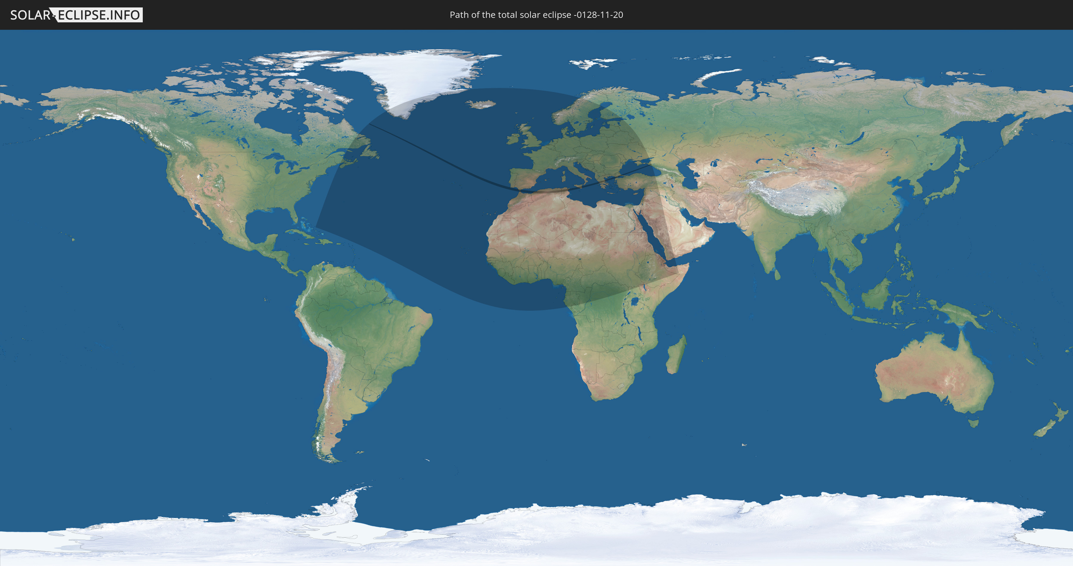
Total solar eclipse of 11/20/-0128
| Day of week: | Monday |
| Maximum duration of eclipse: | 01m10s |
| Maximum width of eclipse path: | 81 km |
| Saros cycle: | 79 |
| Coverage: | 100% |
| Magnitude: | 1.0131 |
| Gamma: | 0.8319 |
Wo kann man die Sonnenfinsternis vom 11/20/-0128 sehen?
Die Sonnenfinsternis am 11/20/-0128 kann man in 100 Ländern als partielle Sonnenfinsternis beobachten.
Der Finsternispfad verläuft durch 10 Länder. Nur in diesen Ländern ist sie als total Sonnenfinsternis zu sehen.
In den folgenden Ländern ist die Sonnenfinsternis total zu sehen
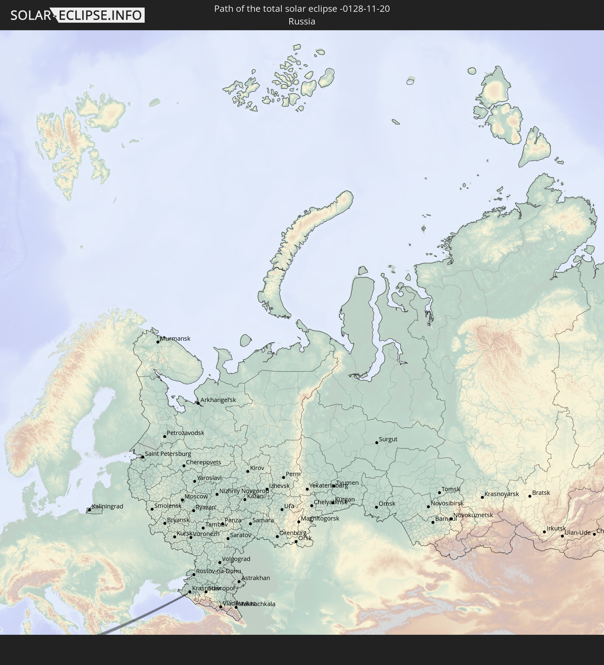 Russia
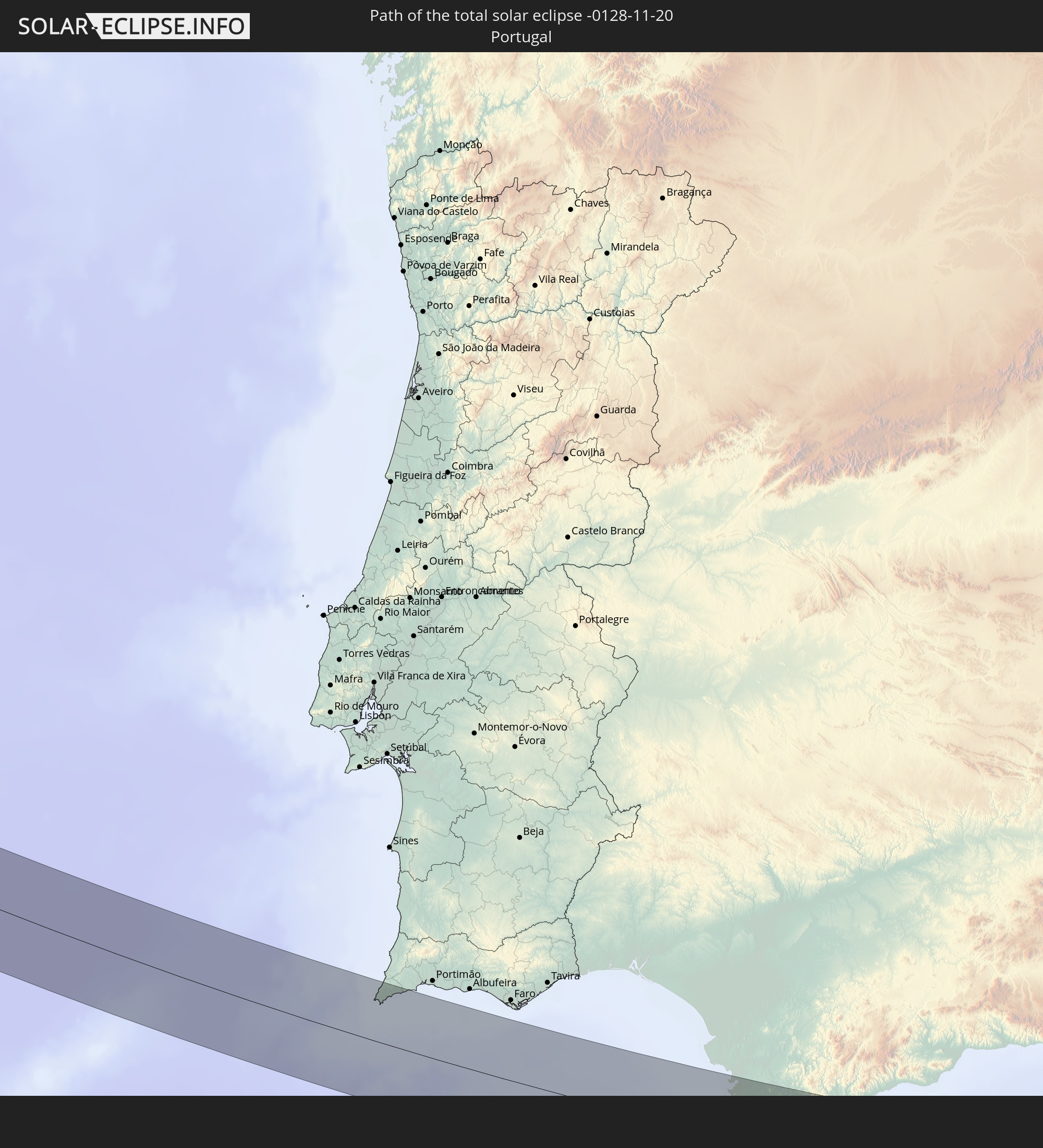 Portugal
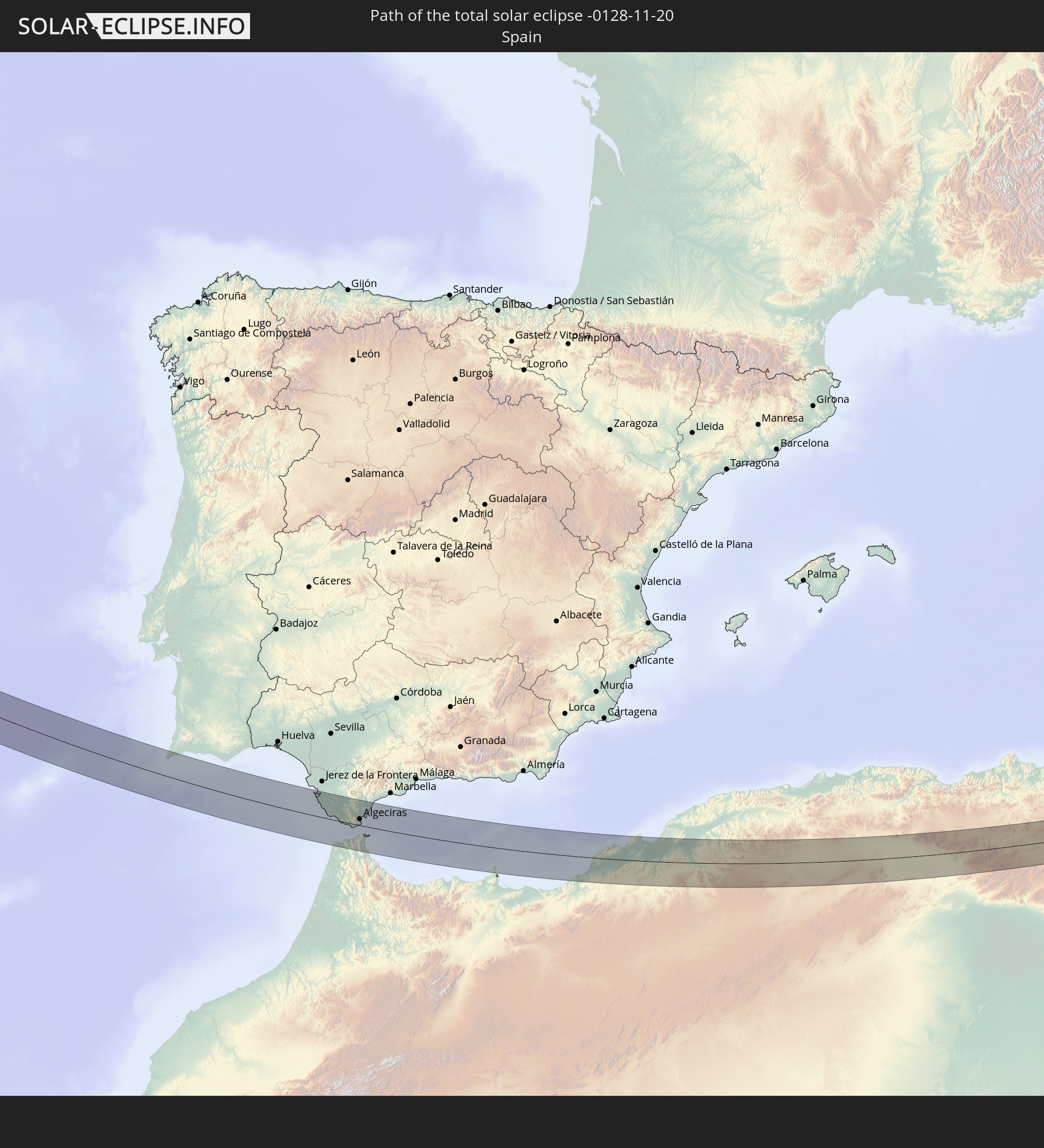 Spain
Spain
 Morocco
 Algeria
 Gibraltar
 Italy
Italy
 Tunisia
 Greece
 Turkey
In den folgenden Ländern ist die Sonnenfinsternis partiell zu sehen
 Russia
 Canada
 Greenland
 Bermuda
 Saint Pierre and Miquelon
 Portugal
 Cabo Verde
 Iceland
 Spain
Spain
 Senegal
 Mauritania
 The Gambia
 Guinea-Bissau
 Guinea
 Sierra Leone
 Morocco
 Mali
Mali
 Liberia
 Republic of Ireland
 Algeria
 United Kingdom
 Ivory Coast
 Faroe Islands
 Burkina Faso
 Gibraltar
 France
 Isle of Man
 Ghana
Ghana
 Guernsey
 Jersey
 Togo
Togo
 Niger
Niger
 Benin
Benin
 Andorra
 Belgium
 Nigeria
 Netherlands
 Norway
 Equatorial Guinea
 Luxembourg
 Germany
 Switzerland
 São Tomé and Príncipe
 Italy
Italy
 Monaco
 Tunisia
 Denmark
 Cameroon
 Gabon
Gabon
 Libya
Libya
 Liechtenstein
 Austria
 Sweden
 Republic of the Congo
 Czechia
 Democratic Republic of the Congo
 San Marino
 Vatican City
 Slovenia
 Chad
Chad
 Croatia
 Poland
 Malta
Malta
 Central African Republic
 Bosnia and Herzegovina
 Hungary
 Slovakia
 Montenegro
 Serbia
 Albania
 Åland Islands
 Greece
 Romania
 Republic of Macedonia
 Finland
 Lithuania
 Latvia
 Estonia
 Sudan
Sudan
 Ukraine
 Bulgaria
 Belarus
 Egypt
Egypt
 Turkey
 Moldova
 Uganda
 Cyprus
 Ethiopia
 Kenya
Kenya
 State of Palestine
 Israel
 Saudi Arabia
 Jordan
 Lebanon
 Syria
Syria
 Eritrea
 Iraq
Iraq
 Somalia
 Djibouti
 Yemen
Yemen
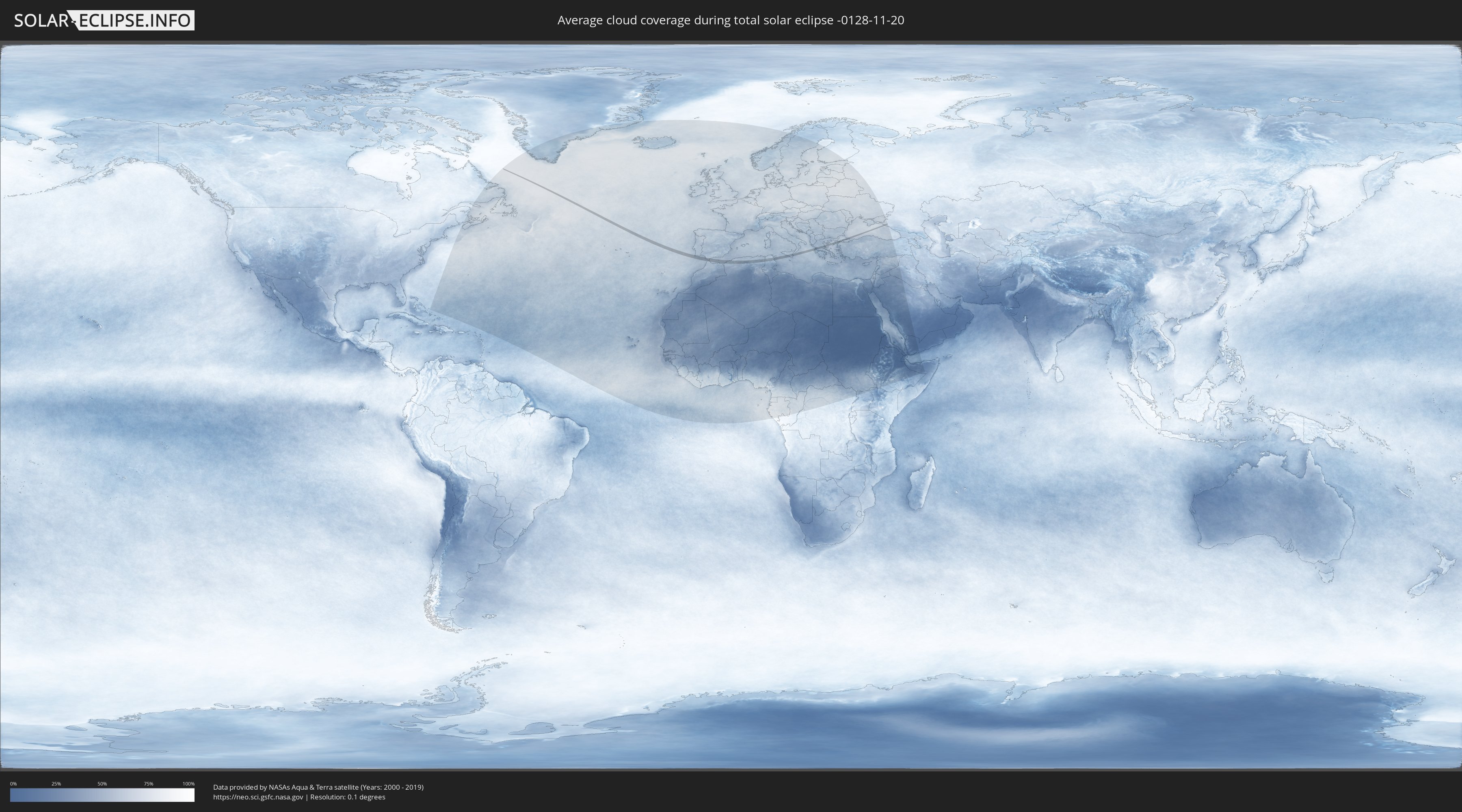
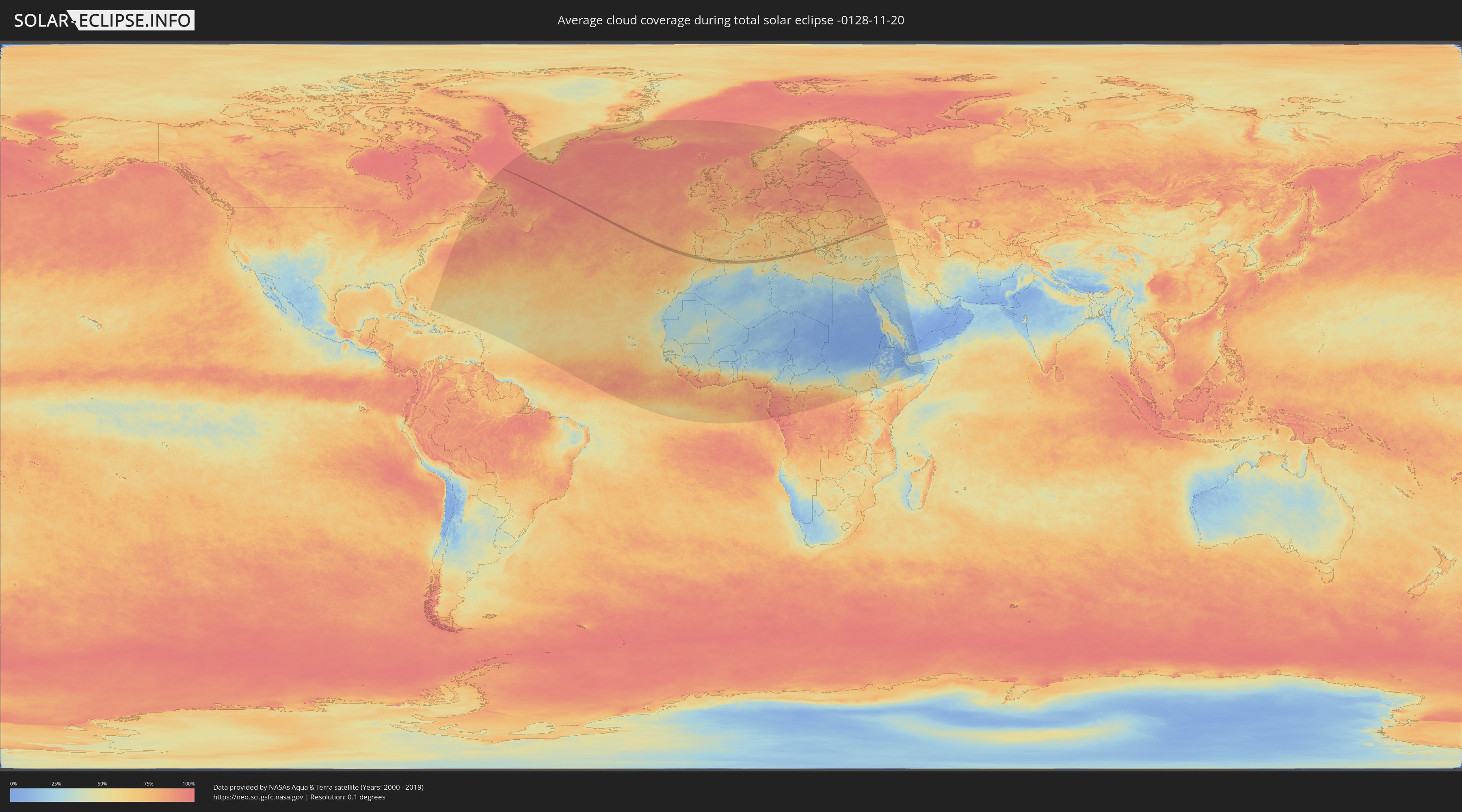
How will be the weather during the total solar eclipse on 11/20/-0128?
Where is the best place to see the total solar eclipse of 11/20/-0128?
The following maps show the average cloud coverage for the day of the total solar eclipse.
With the help of these maps, it is possible to find the place along the eclipse path, which has the best
chance of a cloudless sky.
Nevertheless, you should consider local circumstances and inform about the weather of your chosen
observation site.
The data is provided by NASAs satellites
AQUA and TERRA.
The cloud maps are averaged over a period of 19 years (2000 - 2019).
Detailed country maps
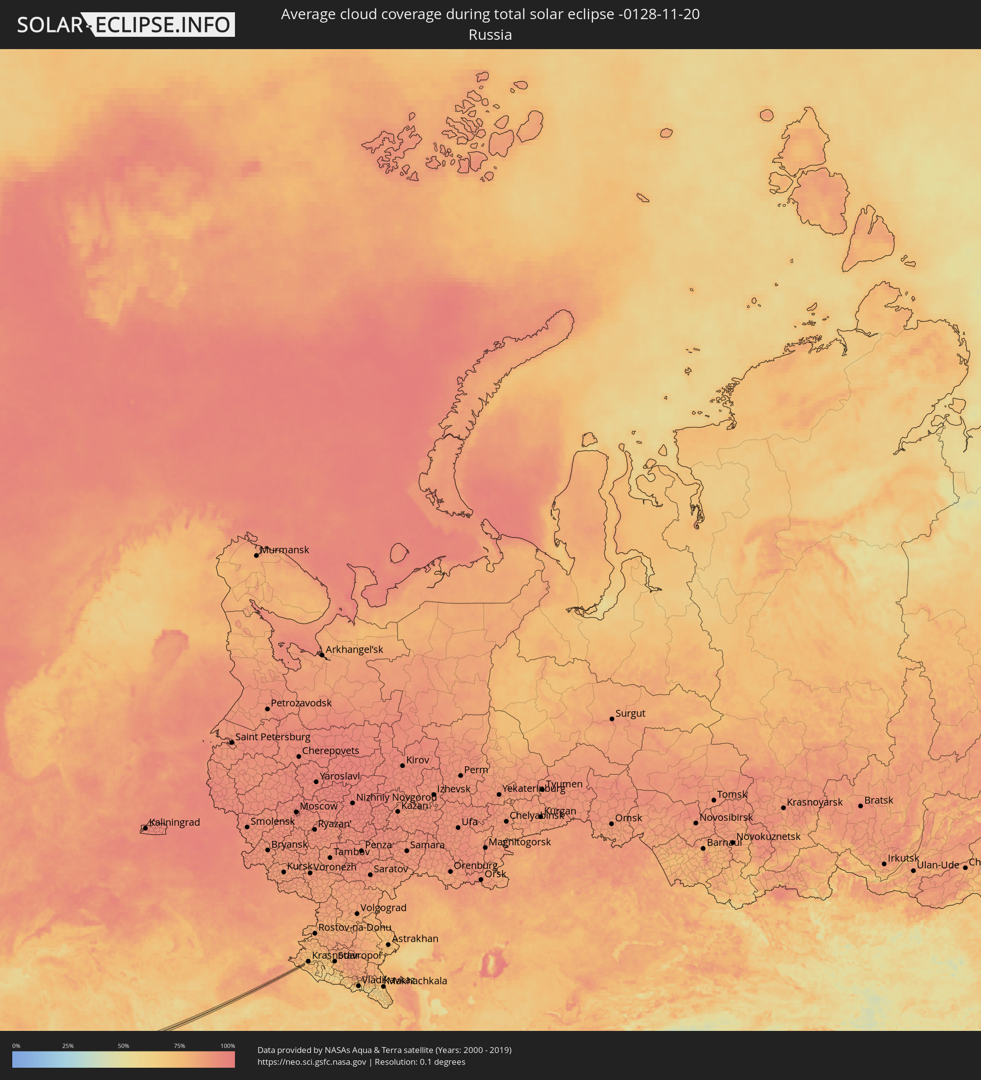 Russia
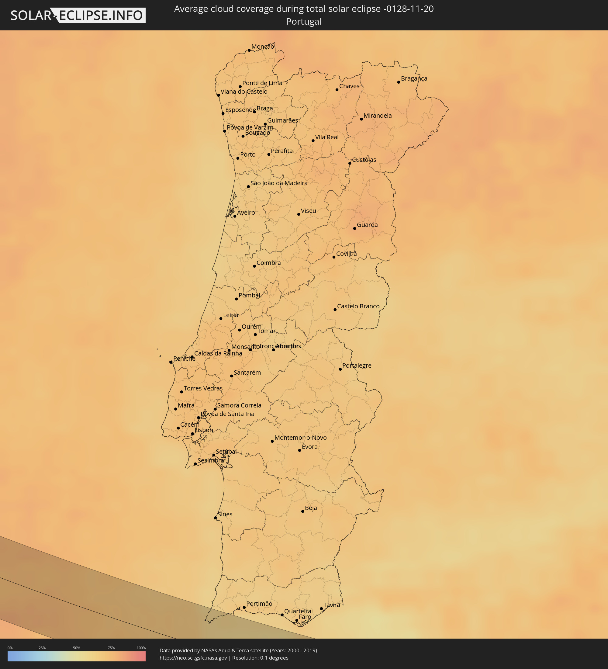 Portugal
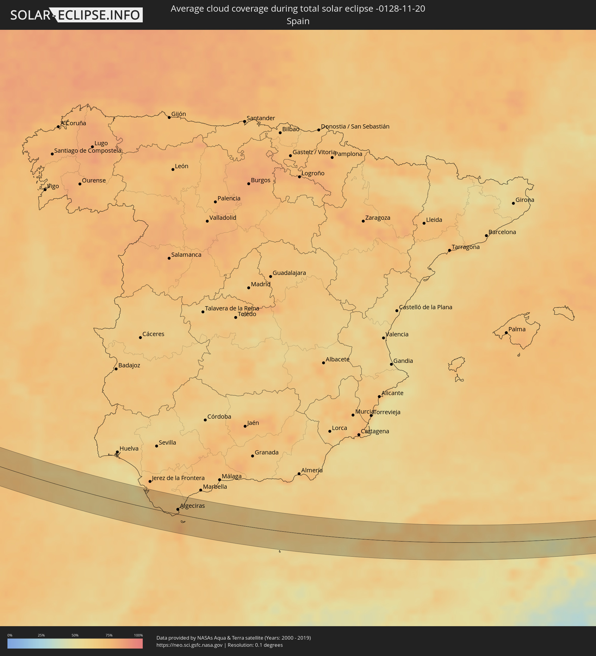 Spain
Spain
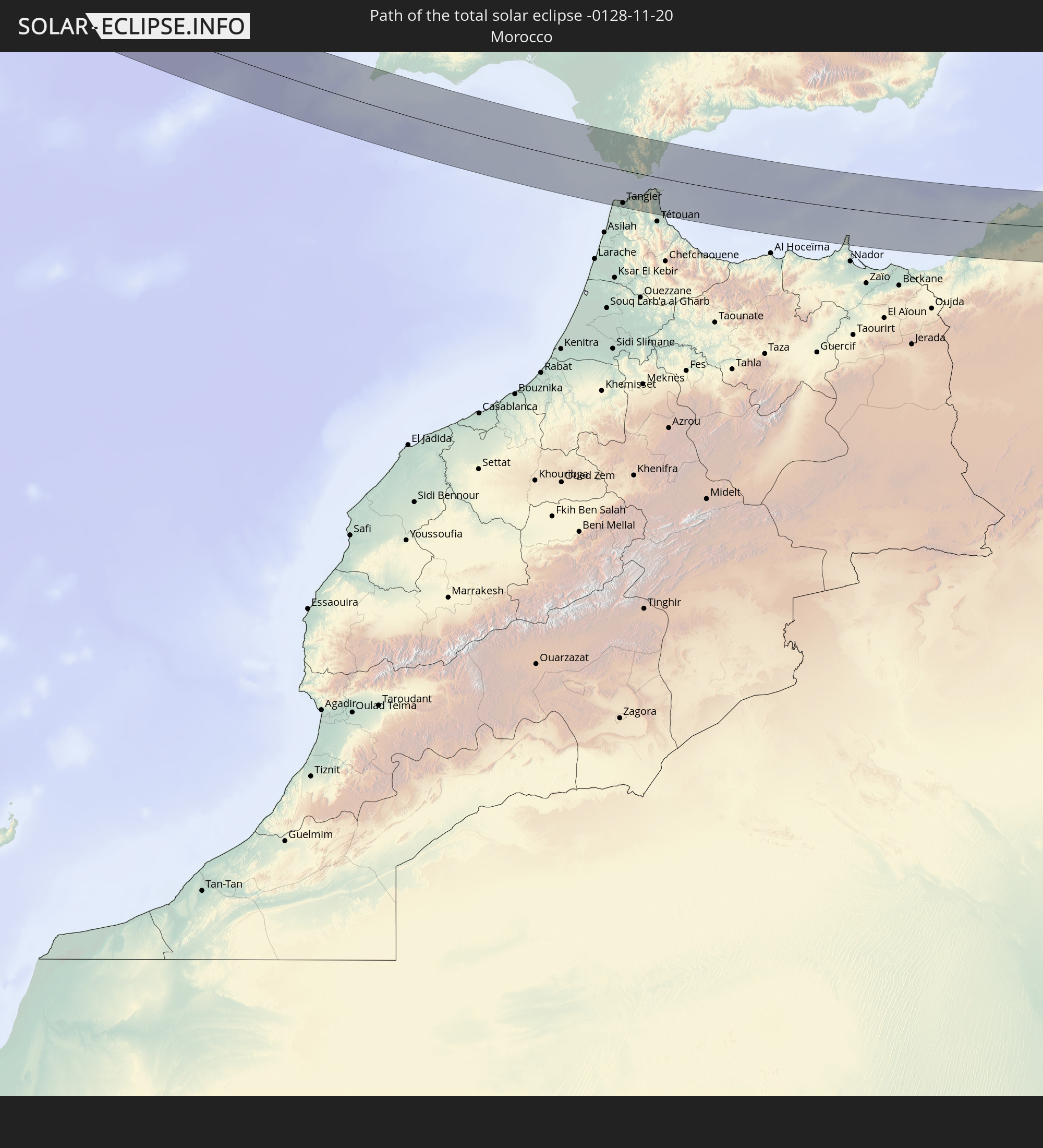
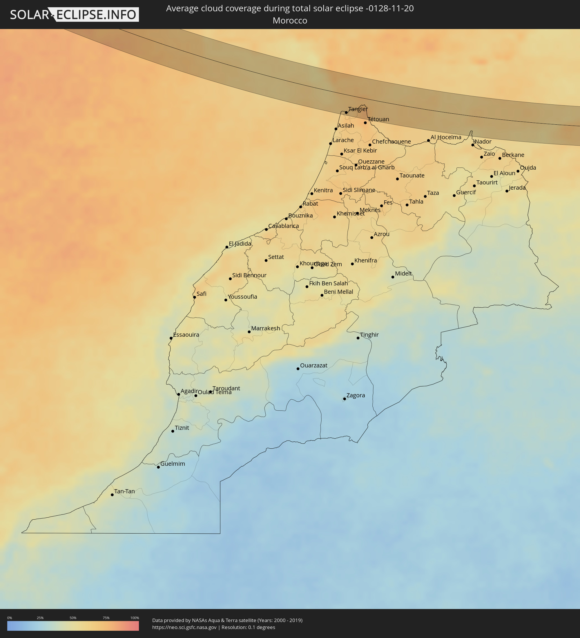 Morocco
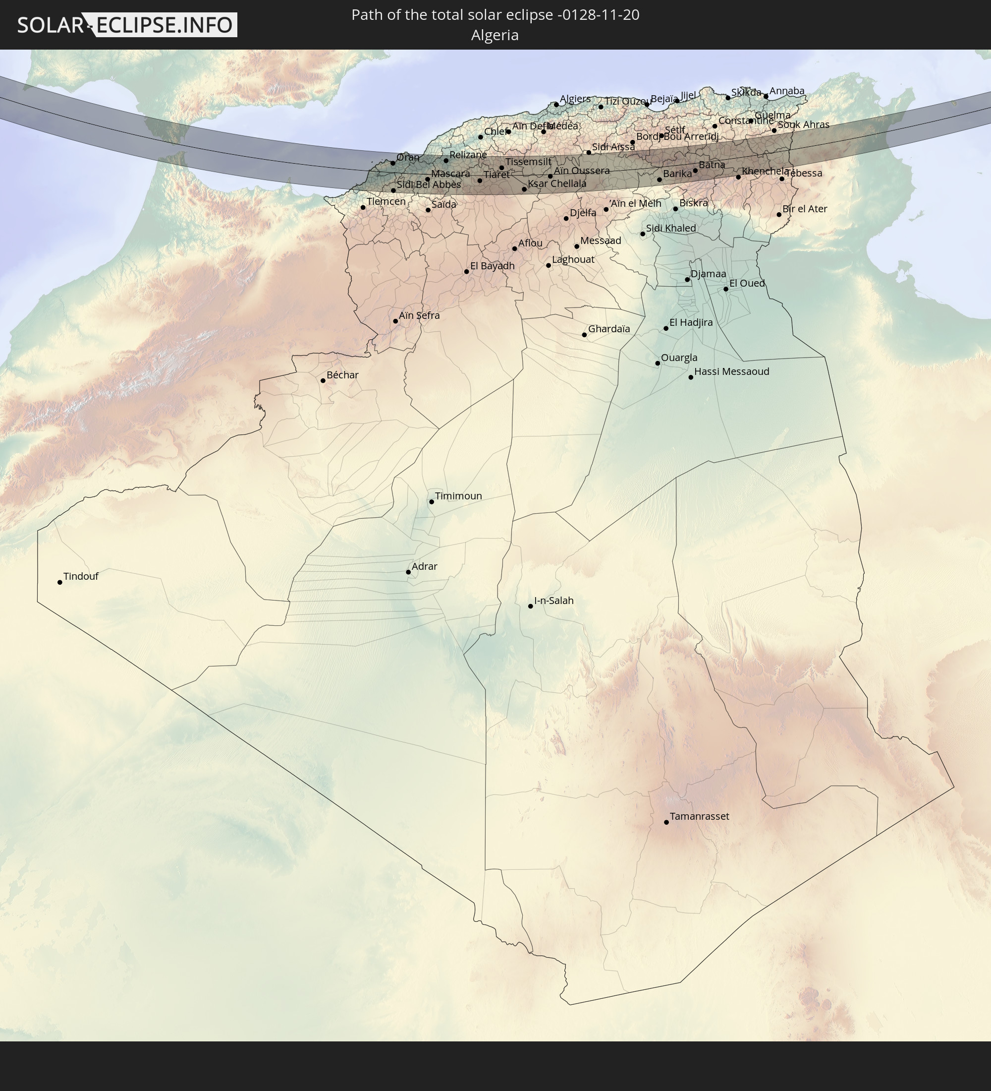
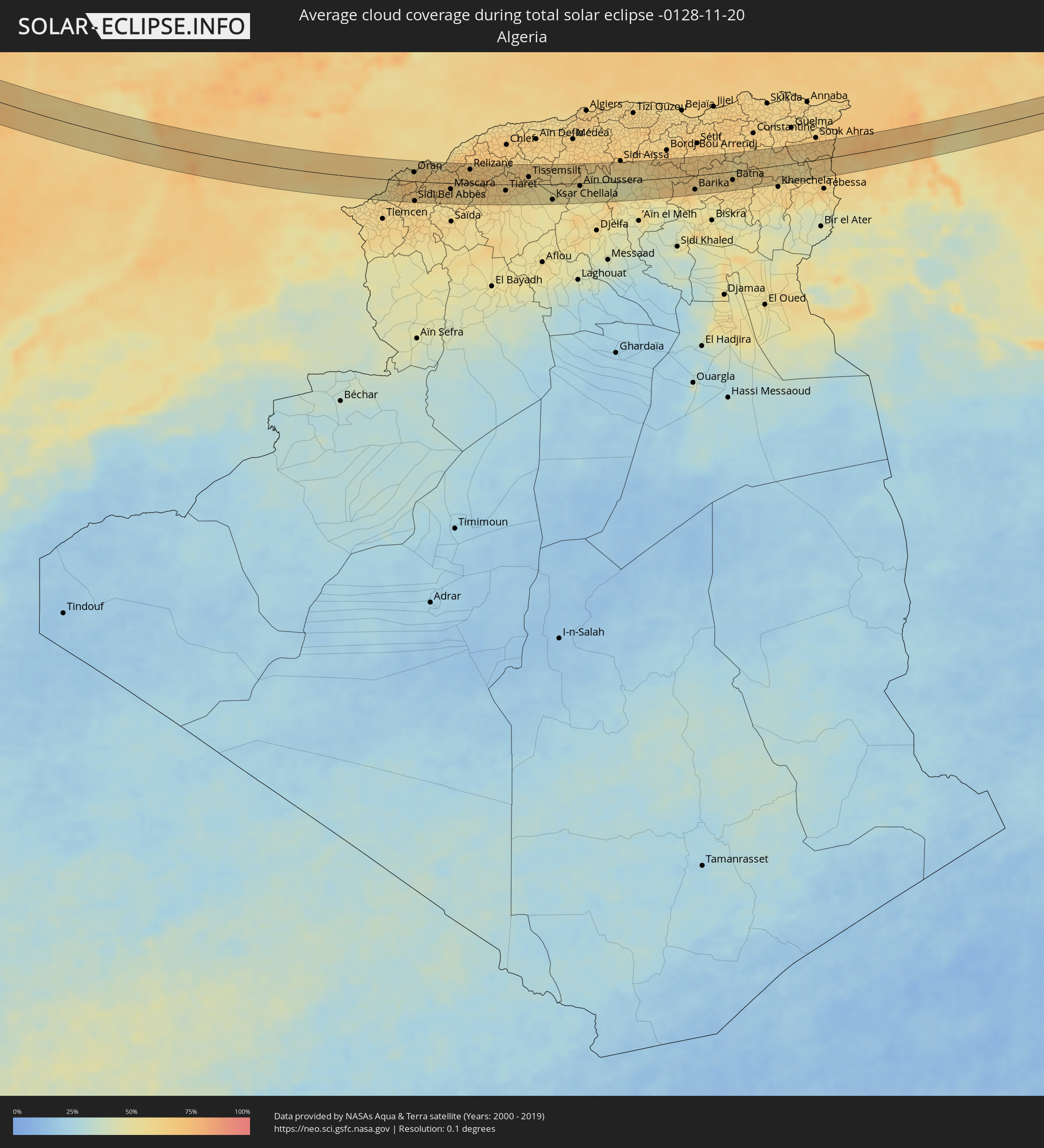 Algeria
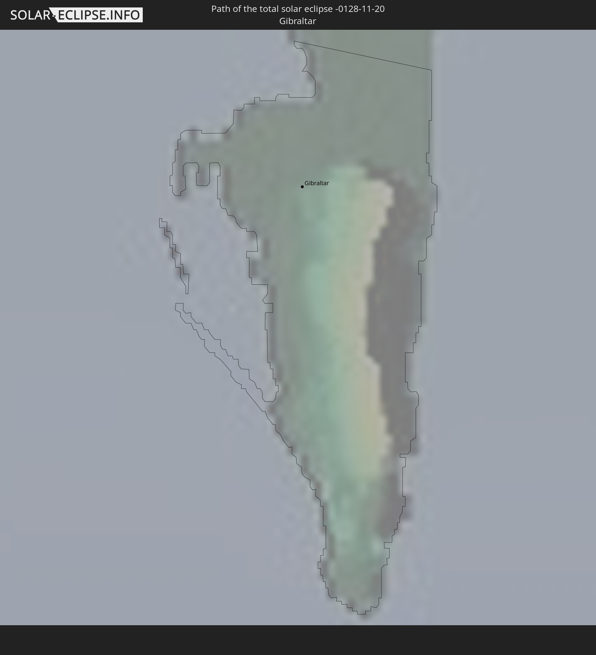
 Gibraltar
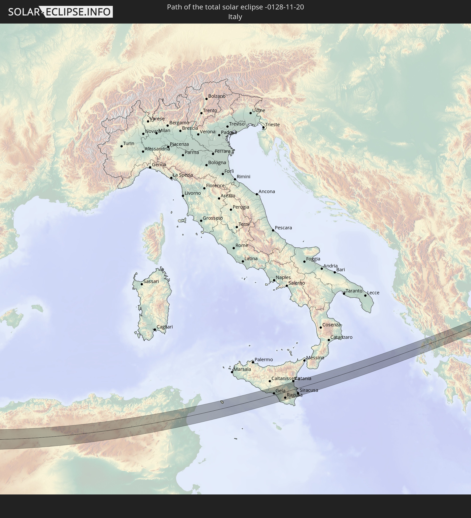
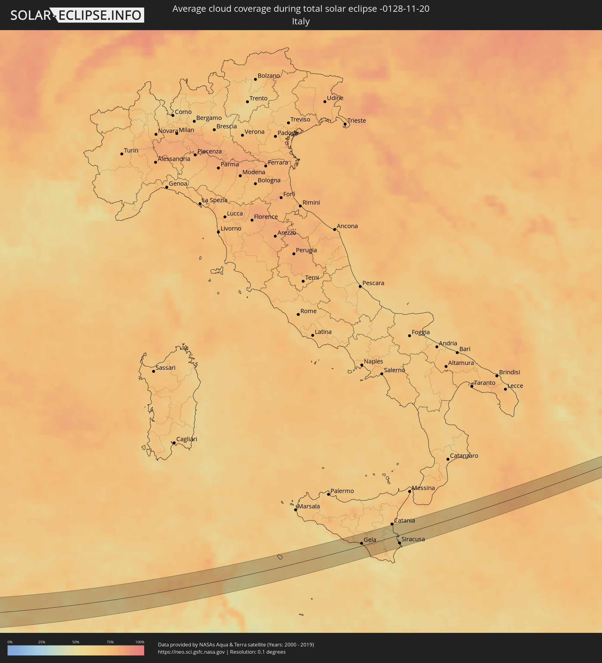 Italy
Italy
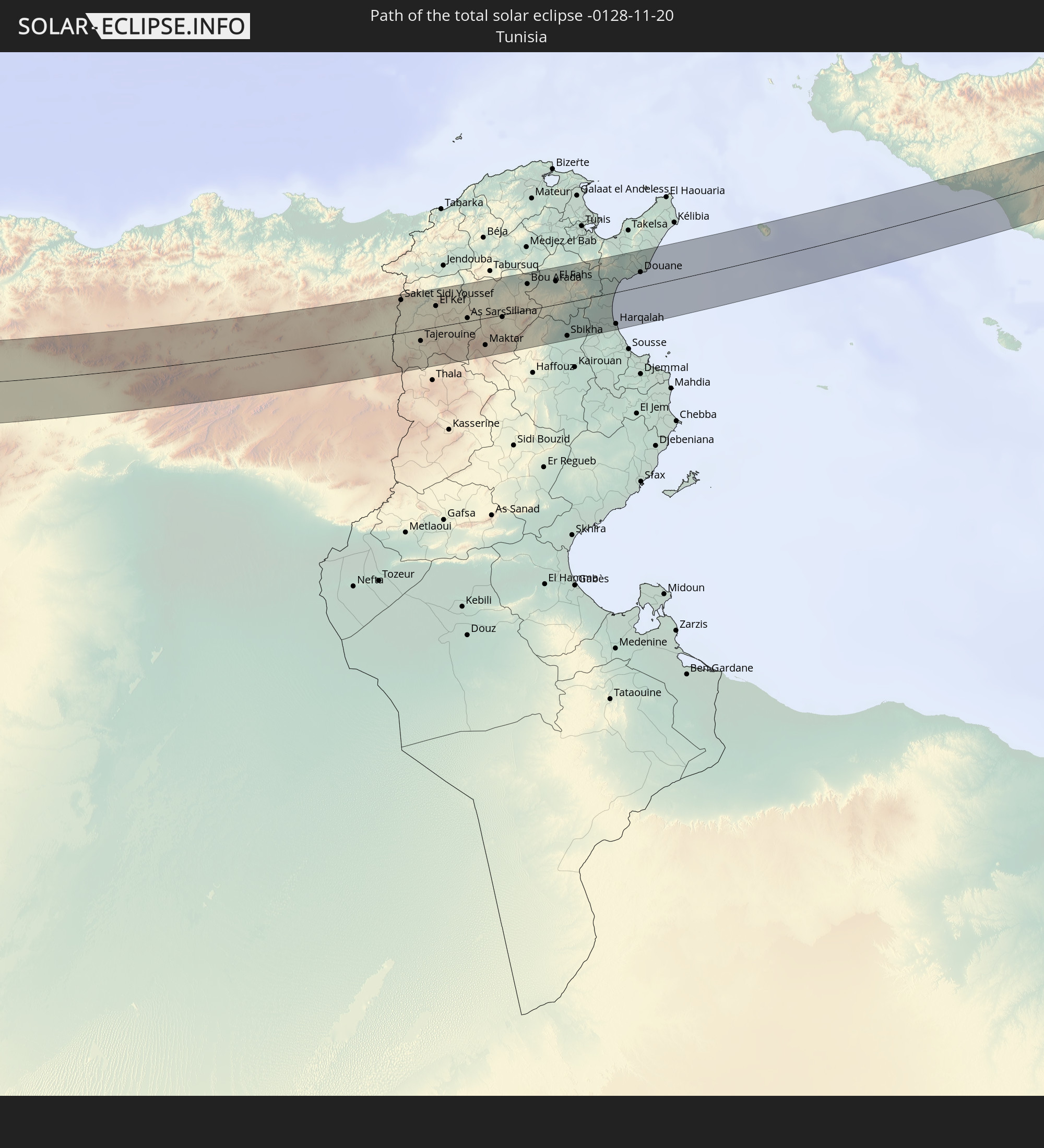
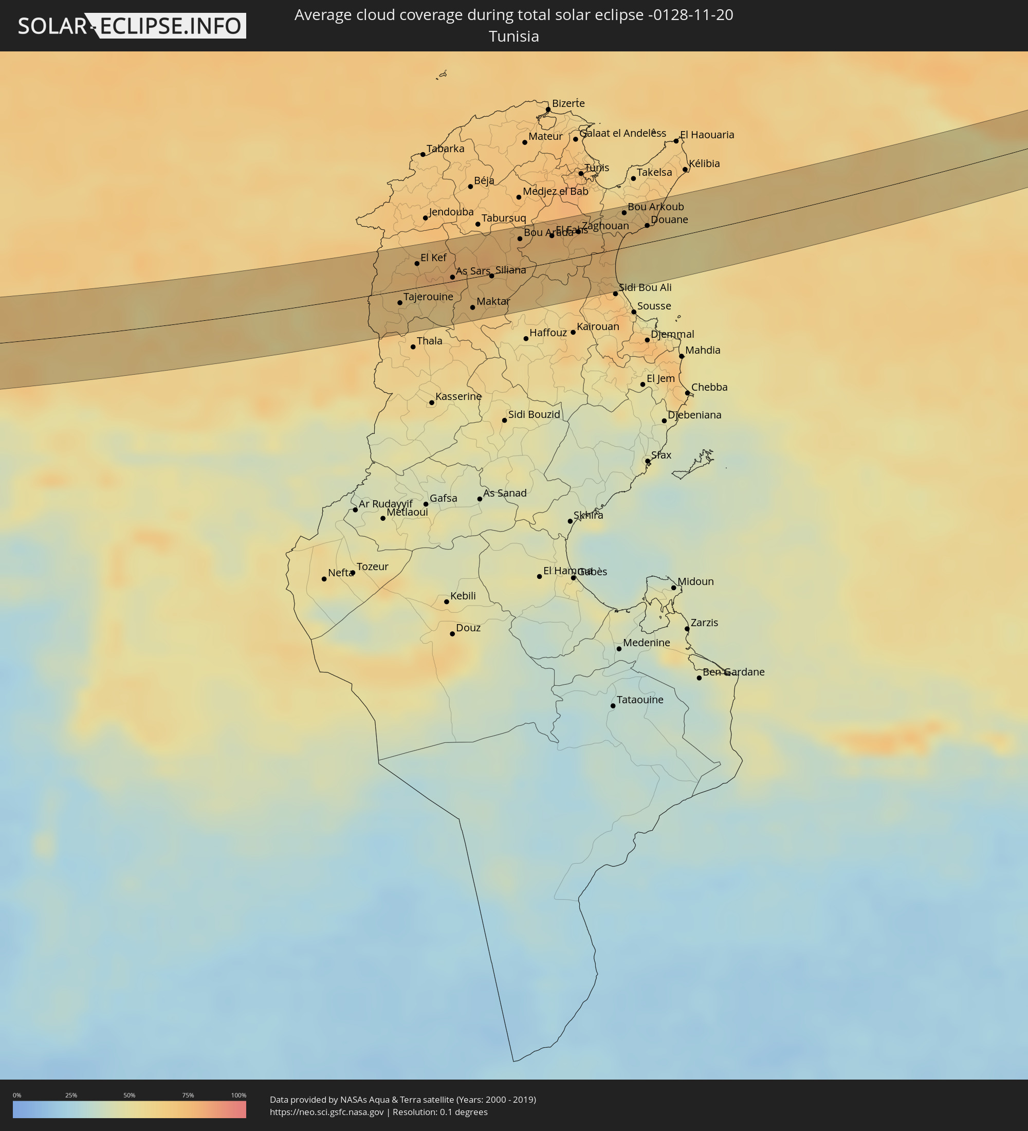 Tunisia
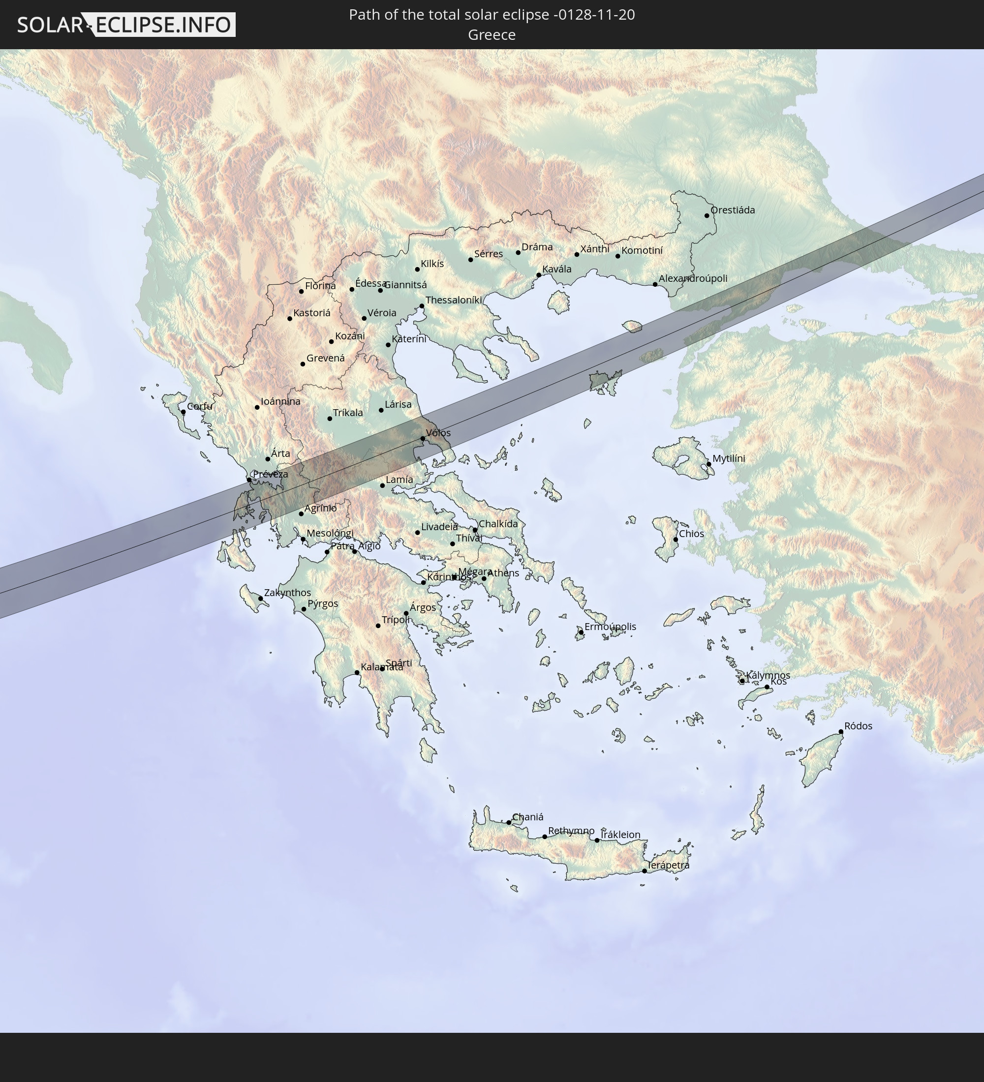
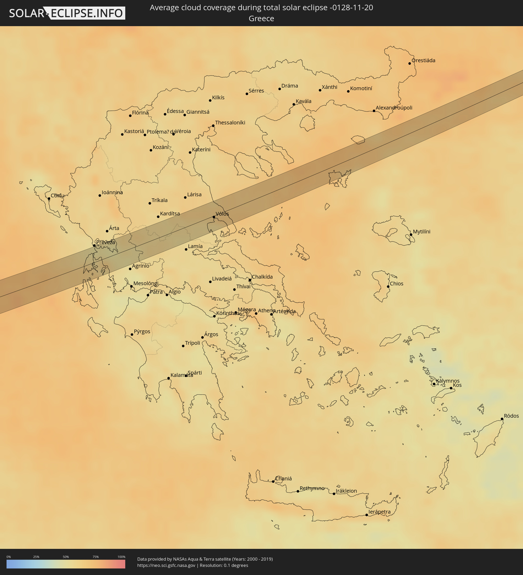 Greece
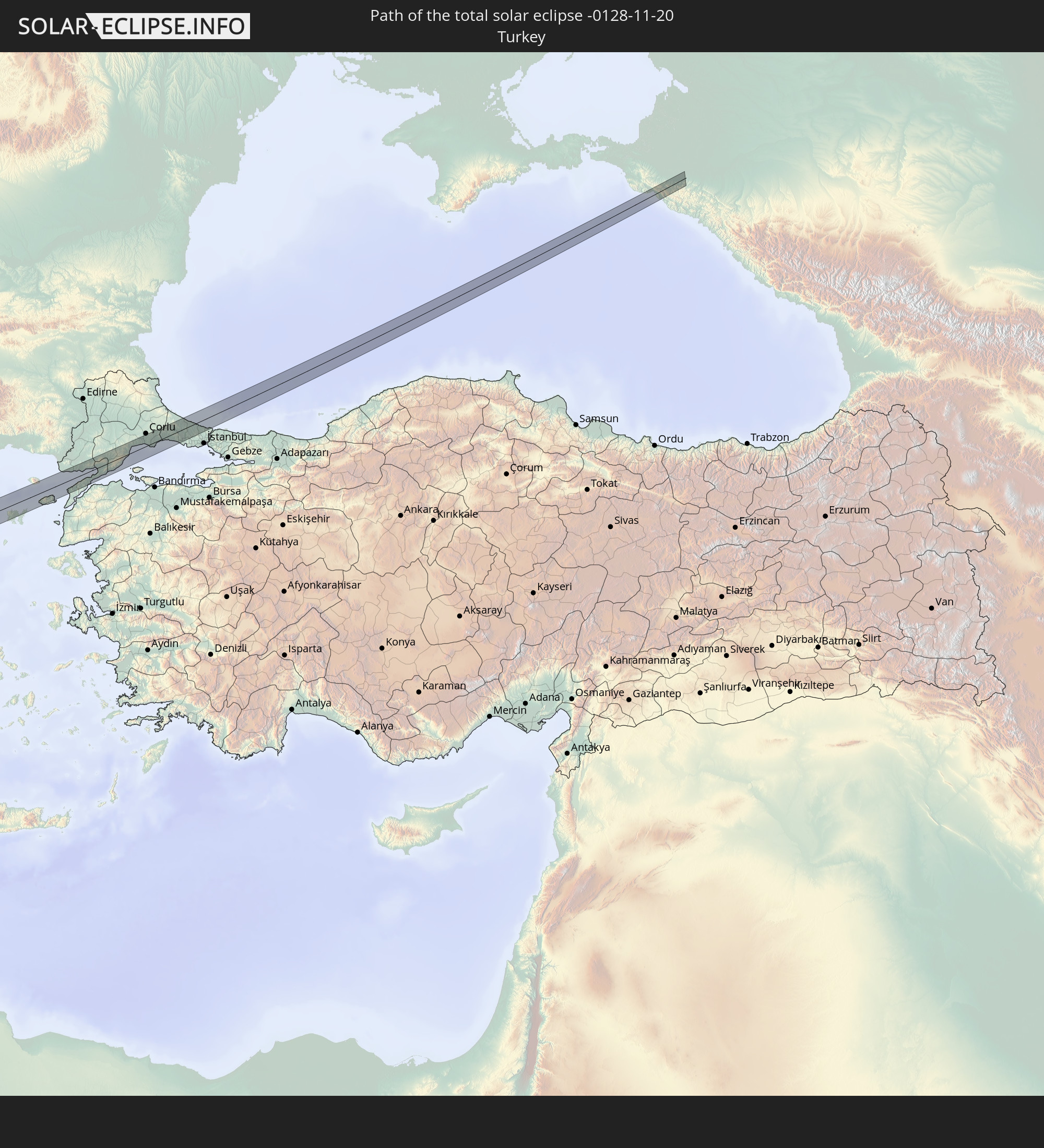
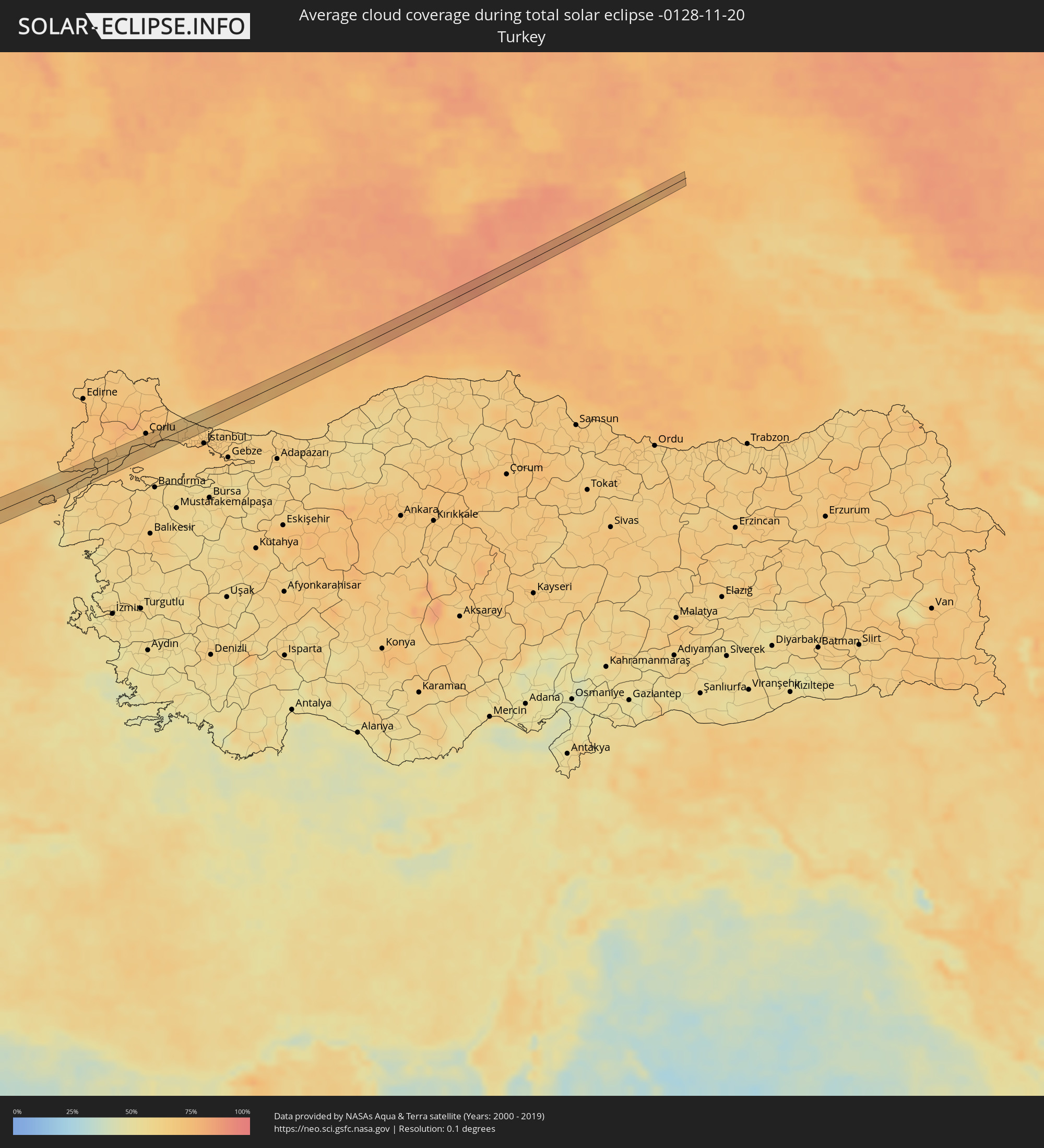 Turkey
Cities inside the path of the eclipse
The following table shows all locations with a population of more than 5,000 inside the eclipse path. Cities which have more than 100,000 inhabitants are marked bold. A click at the locations opens a detailed map.
| City | Type | Eclipse duration | Local time of max. eclipse | Distance to central line | Ø Cloud coverage |
|
Cadiz, Andalusia
|
total | - | 12:57:50 UTC+00:00 | 37 km | 59% |
|
San Fernando, Andalusia
|
total | - | 12:58:05 UTC+00:00 | 33 km | 66% |
|
Puerto Real, Andalusia
|
total | - | 12:58:04 UTC+00:00 | 39 km | 66% |
|
Chiclana de la Frontera, Andalusia
|
total | - | 12:58:14 UTC+00:00 | 28 km | 68% |
|
Conil de la Frontera, Andalusia
|
total | - | 12:58:28 UTC+00:00 | 14 km | 63% |
|
Vejer de la Frontera, Andalusia
|
total | - | 12:58:45 UTC+00:00 | 12 km | 64% |
|
Medina Sidonia, Andalusia
|
total | - | 12:58:43 UTC+00:00 | 36 km | 68% |
|
Barbate de Franco, Andalusia
|
total | - | 12:58:54 UTC+00:00 | 8 km | 67% |
|
Tangier, Tanger-Tétouan
|
total | - | 12:29:07 UTC-00:30 | 36 km | 71% |
|
Alcalá de los Gazules, Andalusia
|
total | - | 12:59:11 UTC+00:00 | 41 km | 68% |
|
Tarifa, Andalusia
|
total | - | 12:59:44 UTC+00:00 | 6 km | 70% |
|
Los Barrios, Andalusia
|
total | - | 12:59:53 UTC+00:00 | 15 km | 75% |
|
Algeciras, Andalusia
|
total | - | 13:00:01 UTC+00:00 | 10 km | 70% |
|
San Roque, Andalusia
|
total | - | 13:00:07 UTC+00:00 | 20 km | 74% |
|
Gibraltar
|
total | - | 13:00:14 UTC+00:00 | 13 km | 70% |
|
La Línea de la Concepción, Andalusia
|
total | - | 13:00:14 UTC+00:00 | 16 km | 70% |
|
Ceuta, Ceuta
|
total | - | 13:00:29 UTC+00:00 | 14 km | 73% |
|
Manilva, Andalusia
|
total | - | 13:00:19 UTC+00:00 | 40 km | 66% |
|
Beni Saf, Aïn Témouchent
|
total | - | 13:19:12 UTC+00:09 | 30 km | 60% |
|
Aïn Temouchent, Aïn Témouchent
|
total | - | 13:19:44 UTC+00:09 | 29 km | 62% |
|
Oran, Oran
|
total | - | 13:20:32 UTC+00:09 | 18 km | 69% |
|
Sidi Bel Abbès, Sidi Bel Abbès
|
total | - | 13:20:58 UTC+00:09 | 38 km | 60% |
|
Sig, Mascara
|
total | - | 13:21:39 UTC+00:09 | 2 km | 64% |
|
Mascara, Mascara
|
total | - | 13:22:29 UTC+00:09 | 12 km | 64% |
|
Relizane, Relizane
|
total | - | 13:23:07 UTC+00:09 | 28 km | 68% |
|
Tiaret, Tiaret
|
total | - | 13:25:04 UTC+00:09 | 12 km | 64% |
|
Sougueur, Tiaret
|
total | - | 13:25:37 UTC+00:09 | 33 km | 55% |
|
Tissemsilt, Tissemsilt
|
total | - | 13:25:56 UTC+00:09 | 14 km | 60% |
|
Ksar Chellala, Tiaret
|
total | - | 13:27:22 UTC+00:09 | 30 km | 52% |
|
Aïn Oussera, Djelfa
|
total | - | 13:28:23 UTC+00:09 | 5 km | 55% |
|
Birine, Djelfa
|
total | - | 13:28:53 UTC+00:09 | 14 km | 52% |
|
‘Aïn el Hadjel, M'Sila
|
total | - | 13:30:13 UTC+00:09 | 15 km | 50% |
|
M’Sila, M'Sila
|
total | - | 13:31:32 UTC+00:09 | 15 km | 64% |
|
Barika, Batna
|
total | - | 13:33:30 UTC+00:09 | 27 km | 59% |
|
Aïn Touta, Batna
|
total | - | 13:34:35 UTC+00:09 | 34 km | 60% |
|
Merouana, Batna
|
total | - | 13:34:21 UTC+00:09 | 6 km | 62% |
|
Batna, Batna
|
total | - | 13:34:57 UTC+00:09 | 17 km | 63% |
|
Aïn Fakroun, Oum el Bouaghi
|
total | - | 13:35:54 UTC+00:09 | 21 km | 62% |
|
Oum el Bouaghi, Oum el Bouaghi
|
total | - | 13:36:27 UTC+00:09 | 8 km | 61% |
|
Aïn Beïda, Oum el Bouaghi
|
total | - | 13:37:04 UTC+00:09 | 4 km | 57% |
|
Sedrata, Souk Ahras
|
total | - | 13:37:00 UTC+00:09 | 30 km | 60% |
|
Sakiet Sidi Youssef, Kef
|
total | - | 13:38:27 UTC+00:09 | 29 km | 69% |
|
Tajerouine, Kef
|
total | - | 13:39:09 UTC+00:09 | 10 km | 63% |
|
El Kef, Kef
|
total | - | 13:39:09 UTC+00:09 | 19 km | 75% |
|
El Ksour, Kef
|
total | - | 13:39:46 UTC+00:09 | 15 km | 61% |
|
As Sars, Kef
|
total | - | 13:39:50 UTC+00:09 | 3 km | 72% |
|
Le Krib, Silyānah
|
total | - | 13:39:46 UTC+00:09 | 29 km | 74% |
|
Maktar, Silyānah
|
total | - | 13:40:23 UTC+00:09 | 24 km | 66% |
|
Gafour, Silyānah
|
total | - | 13:40:07 UTC+00:09 | 25 km | 76% |
|
Siliana, Silyānah
|
total | - | 13:40:27 UTC+00:09 | 2 km | 70% |
|
Bou Arada, Silyānah
|
total | - | 13:40:38 UTC+00:09 | 23 km | 75% |
|
El Fahs, Zaghwān
|
total | - | 13:41:07 UTC+00:09 | 21 km | 75% |
|
Sbikha, Al Qayrawān
|
total | - | 13:41:48 UTC+00:09 | 30 km | 60% |
|
Zaghouan, Zaghwān
|
total | - | 13:41:30 UTC+00:09 | 19 km | 70% |
|
Harqalah, Sūsah
|
total | - | 13:42:33 UTC+00:09 | 28 km | 66% |
|
Bou Arkoub, Nābul
|
total | - | 13:42:05 UTC+00:09 | 27 km | 70% |
|
Hammamet, Nābul
|
total | - | 13:42:21 UTC+00:09 | 10 km | 61% |
|
Nabeul, Nābul
|
total | - | 13:42:30 UTC+00:09 | 14 km | 68% |
|
Dar Chabanne, Nābul
|
total | - | 13:42:31 UTC+00:09 | 15 km | 62% |
|
Douane, Nābul
|
total | - | 13:42:32 UTC+00:09 | 13 km | 55% |
|
Beni Khiar, Nābul
|
total | - | 13:42:34 UTC+00:09 | 15 km | 62% |
|
El Maamoura, Nābul
|
total | - | 13:42:36 UTC+00:09 | 14 km | 62% |
|
Korba, Nābul
|
total | - | 13:42:34 UTC+00:09 | 25 km | 62% |
|
Palma di Montechiaro, Sicily
|
total | - | 14:37:24 UTC+01:00 | 29 km | 62% |
|
Licata, Sicily
|
total | - | 14:37:46 UTC+01:00 | 16 km | 54% |
|
Gela, Sicily
|
total | - | 14:38:17 UTC+01:00 | 5 km | 55% |
|
Acate, Sicily
|
total | - | 14:38:44 UTC+01:00 | 6 km | 70% |
|
Caltagirone, Sicily
|
total | - | 14:38:31 UTC+01:00 | 16 km | 70% |
|
Santa Croce Camerina, Sicily
|
total | - | 14:39:01 UTC+01:00 | 28 km | 53% |
|
Vittoria, Sicily
|
total | - | 14:38:52 UTC+01:00 | 15 km | 70% |
|
Comiso, Sicily
|
total | - | 14:39:00 UTC+01:00 | 17 km | 64% |
|
Grammichele, Sicily
|
total | - | 14:38:44 UTC+01:00 | 11 km | 73% |
|
Ramacca, Sicily
|
total | - | 14:38:38 UTC+01:00 | 28 km | 62% |
|
Ragusa, Sicily
|
total | - | 14:39:13 UTC+01:00 | 22 km | 67% |
|
Palagonia, Sicily
|
total | - | 14:38:46 UTC+01:00 | 20 km | 63% |
|
Militello in Val di Catania, Sicily
|
total | - | 14:38:55 UTC+01:00 | 14 km | 60% |
|
Scordia, Sicily
|
total | - | 14:38:58 UTC+01:00 | 14 km | 60% |
|
Francofonte, Sicily
|
total | - | 14:39:06 UTC+01:00 | 6 km | 61% |
|
Palazzolo Acreide, Sicily
|
total | - | 14:39:20 UTC+01:00 | 12 km | 67% |
|
Lentini, Sicily
|
total | - | 14:39:13 UTC+01:00 | 10 km | 59% |
|
Carlentini, Sicily
|
total | - | 14:39:14 UTC+01:00 | 9 km | 59% |
|
Sortino, Sicily
|
total | - | 14:39:25 UTC+01:00 | 5 km | 62% |
|
Floridia, Sicily
|
total | - | 14:39:41 UTC+01:00 | 16 km | 63% |
|
Priolo Gargallo, Sicily
|
total | - | 14:39:39 UTC+01:00 | 9 km | 64% |
|
Augusta, Sicily
|
total | - | 14:39:37 UTC+01:00 | 1 km | 64% |
|
Siracusa, Sicily
|
total | - | 14:39:53 UTC+01:00 | 19 km | 60% |
|
Lefkáda, Ionian Islands
|
total | - | 15:20:11 UTC+01:34 | 13 km | 60% |
|
Karpenísi, Central Greece
|
total | - | 15:21:26 UTC+01:34 | 12 km | 56% |
|
Fársala, Thessaly
|
total | - | 15:21:38 UTC+01:34 | 9 km | 58% |
|
Almyrós, Thessaly
|
total | - | 15:22:13 UTC+01:34 | 15 km | 56% |
|
Néa Anchiálos, Thessaly
|
total | - | 15:22:10 UTC+01:34 | 7 km | 57% |
|
Néa Ionía, Thessaly
|
total | - | 15:22:10 UTC+01:34 | 0 km | 62% |
|
Vólos, Thessaly
|
total | - | 15:22:12 UTC+01:34 | 2 km | 62% |
|
Agriá, Thessaly
|
total | - | 15:22:19 UTC+01:34 | 6 km | 57% |
|
Mýrina, North Aegean
|
total | - | 15:23:54 UTC+01:34 | 19 km | 67% |
|
Gökçeada, Çanakkale Province
|
total | - | 15:46:25 UTC+01:56 | 14 km | 68% |
|
Gelibolu, Çanakkale Province
|
total | - | 15:46:54 UTC+01:56 | 18 km | 63% |
|
Tekirdağ, Tekirdağ
|
total | - | 15:46:58 UTC+01:56 | 11 km | 69% |
|
Marmara Ereğlisi, Tekirdağ
|
total | - | 15:47:24 UTC+01:56 | 6 km | 67% |
|
Çanta, Istanbul
|
total | - | 15:47:22 UTC+01:56 | 1 km | 64% |
|
Silivri, Istanbul
|
total | - | 15:47:31 UTC+01:56 | 5 km | 64% |
|
Kavaklı, Istanbul
|
total | - | 15:47:35 UTC+01:56 | 6 km | 63% |
|
Selimpaşa, Istanbul
|
total | - | 15:47:40 UTC+01:56 | 11 km | 65% |
|
Celâliye, Istanbul
|
total | - | 15:47:43 UTC+01:56 | 13 km | 65% |
|
Çatalca, Istanbul
|
total | - | 15:47:38 UTC+01:56 | 6 km | 64% |
|
Boyalık, Istanbul
|
total | - | 15:47:37 UTC+01:56 | 1 km | 69% |
|
Myskhako, Krasnodarskiy
|
total | - | 16:22:54 UTC+02:30 | 9 km | 74% |
|
Kabardinka, Krasnodarskiy
|
total | - | 16:23:02 UTC+02:30 | 1 km | 74% |
|
Akhtyrskiy, Krasnodarskiy
|
total | - | 16:22:57 UTC+02:30 | 16 km | 77% |
|
Kholmskiy, Krasnodarskiy
|
total | - | 16:23:00 UTC+02:30 | 9 km | 76% |