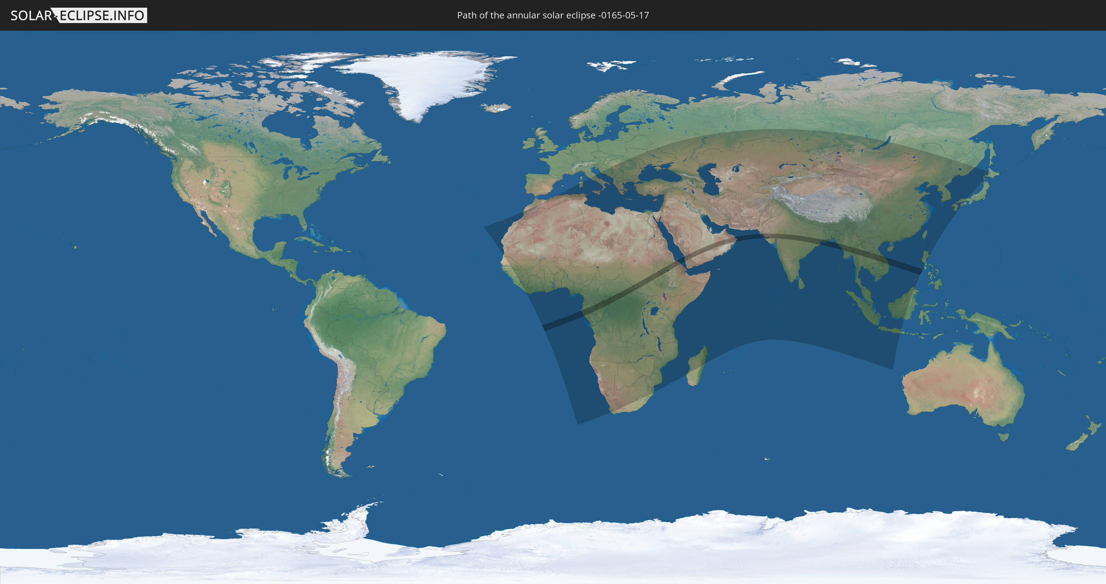
Annular solar eclipse of 05/17/-0165
| Day of week: | Friday |
| Maximum duration of eclipse: | 05m21s |
| Maximum width of eclipse path: | 156 km |
| Saros cycle: | 64 |
| Coverage: | 95.7% |
| Magnitude: | 0.9573 |
| Gamma: | 0.0443 |
Wo kann man die Sonnenfinsternis vom 05/17/-0165 sehen?
Die Sonnenfinsternis am 05/17/-0165 kann man in 123 Ländern als partielle Sonnenfinsternis beobachten.
Der Finsternispfad verläuft durch 21 Länder. Nur in diesen Ländern ist sie als annular Sonnenfinsternis zu sehen.
In den folgenden Ländern ist die Sonnenfinsternis annular zu sehen
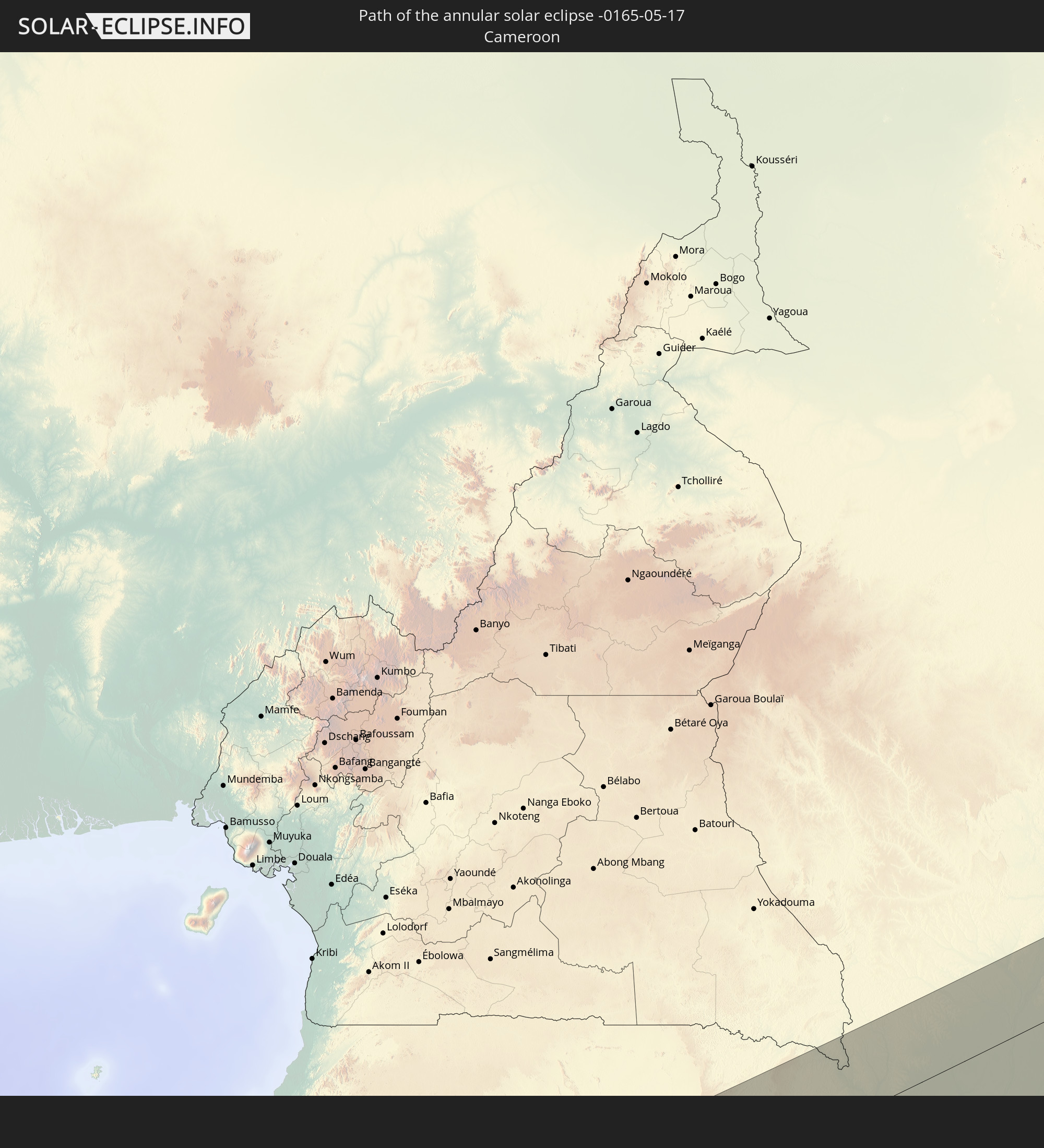 Cameroon
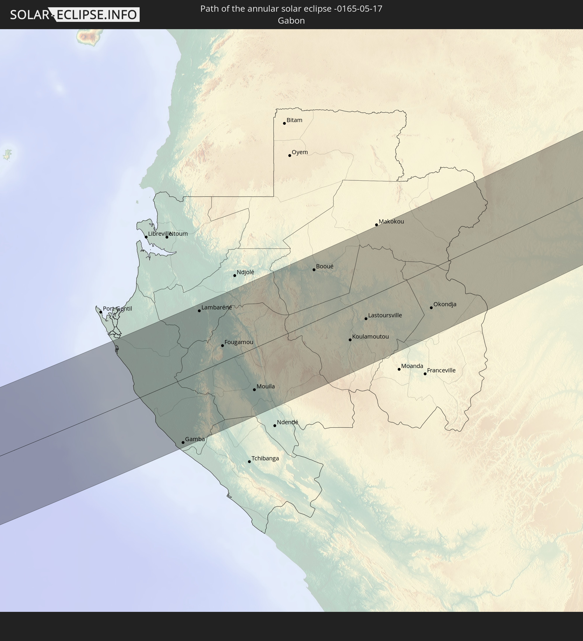 Gabon
Gabon
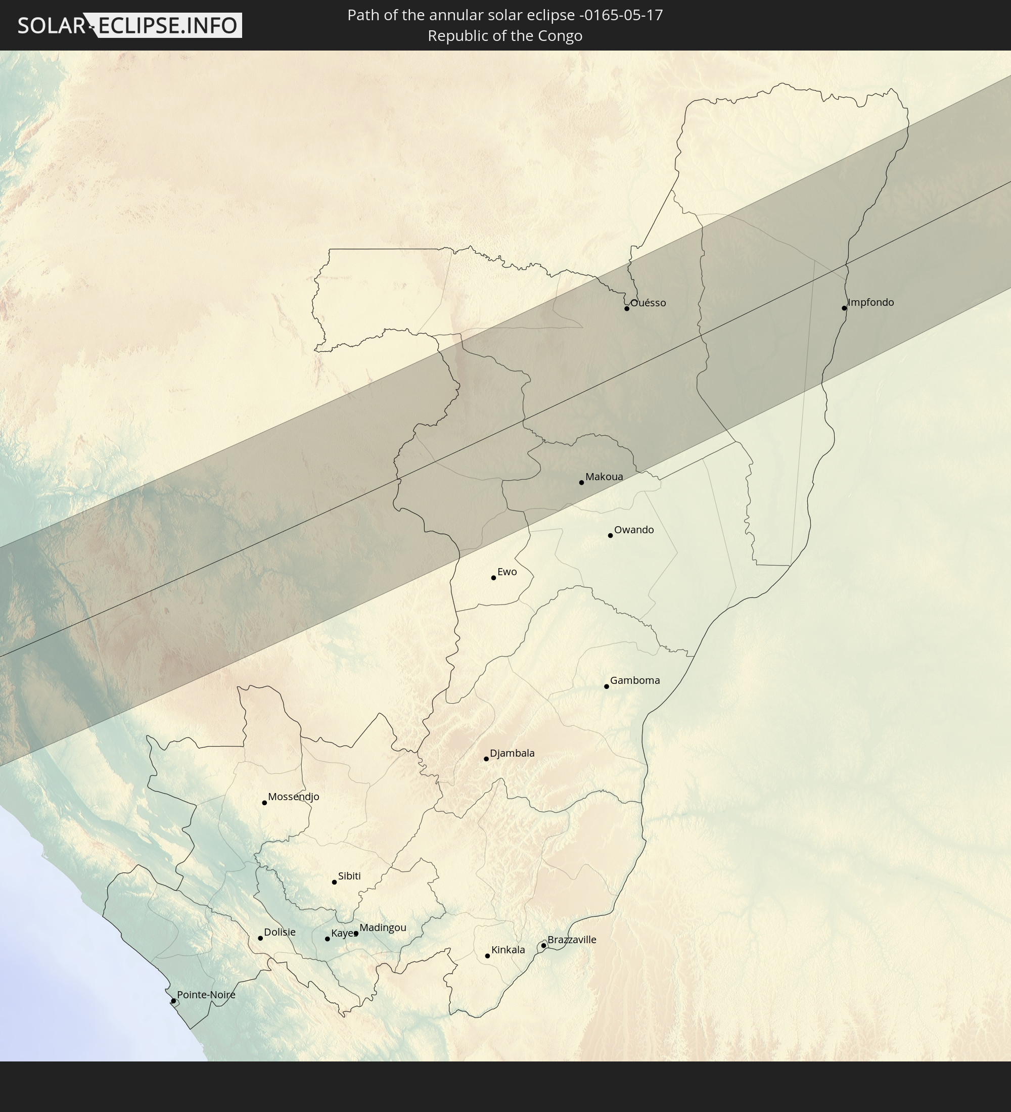 Republic of the Congo
 Democratic Republic of the Congo
 Central African Republic
 Sudan
Sudan
 South Sudan
 Ethiopia
 Saudi Arabia
 Eritrea
 Yemen
Yemen
 Oman
Oman
 Pakistan
 India
India
 Bangladesh
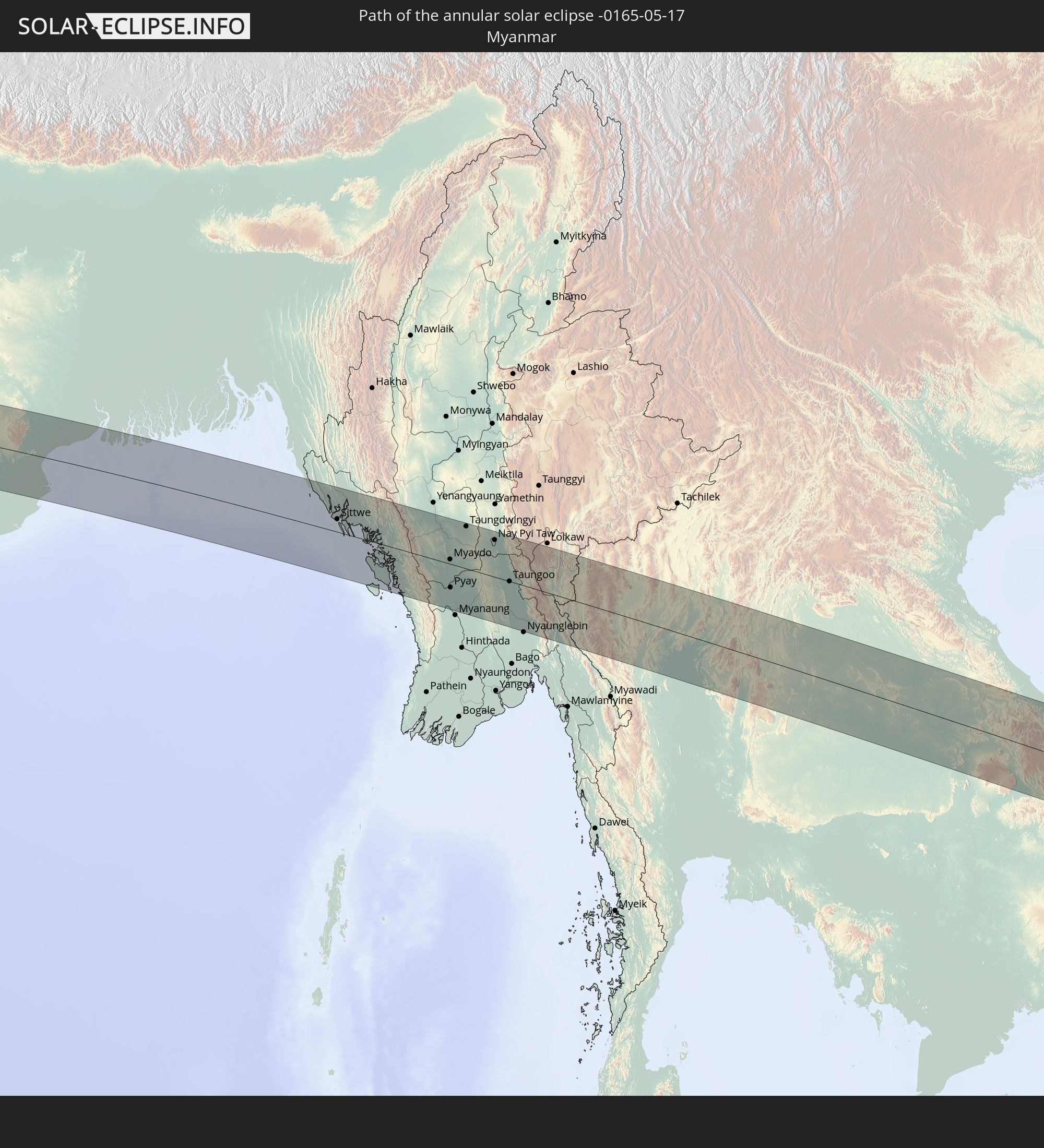 Myanmar
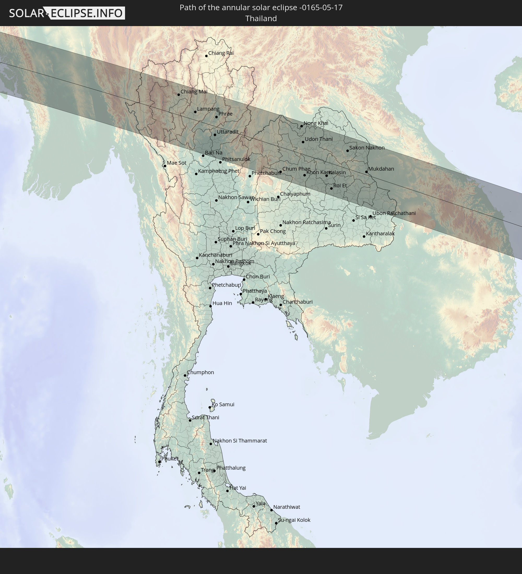 Thailand
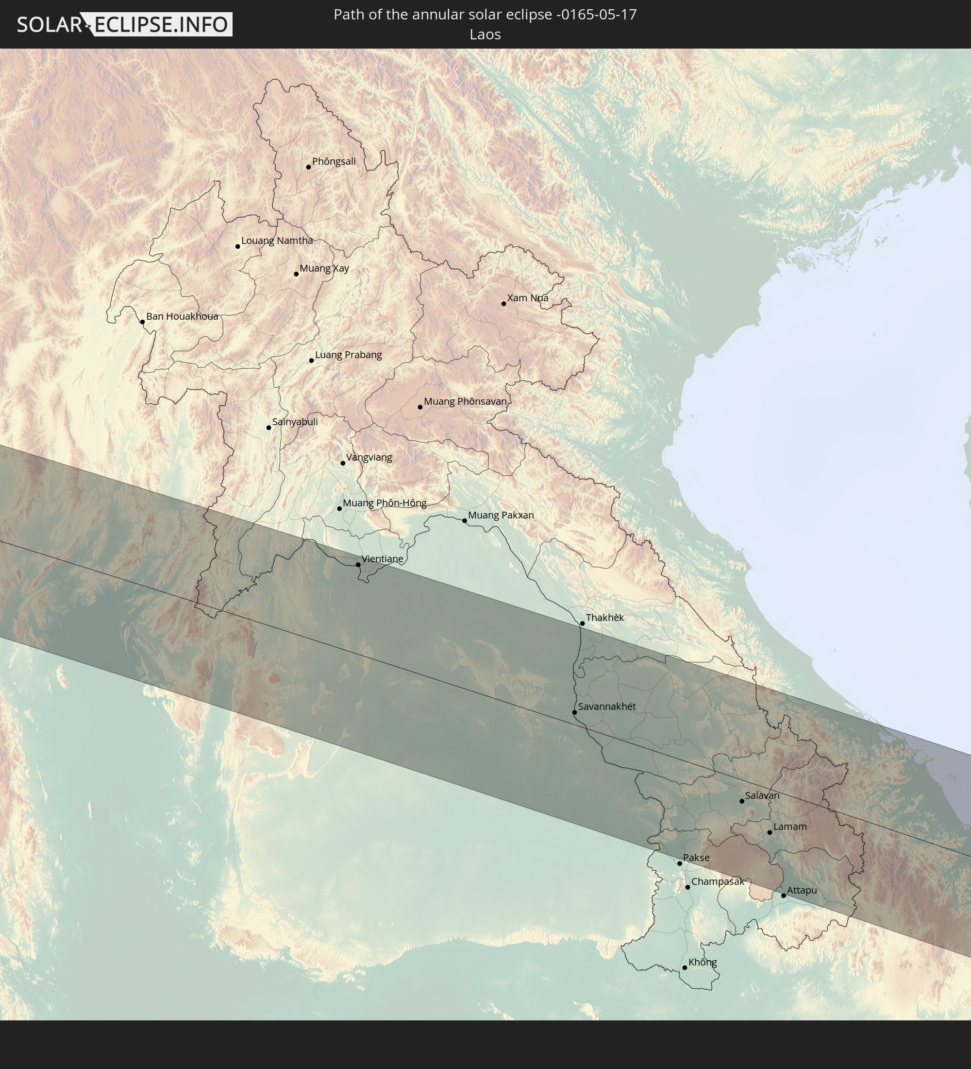 Laos
Laos
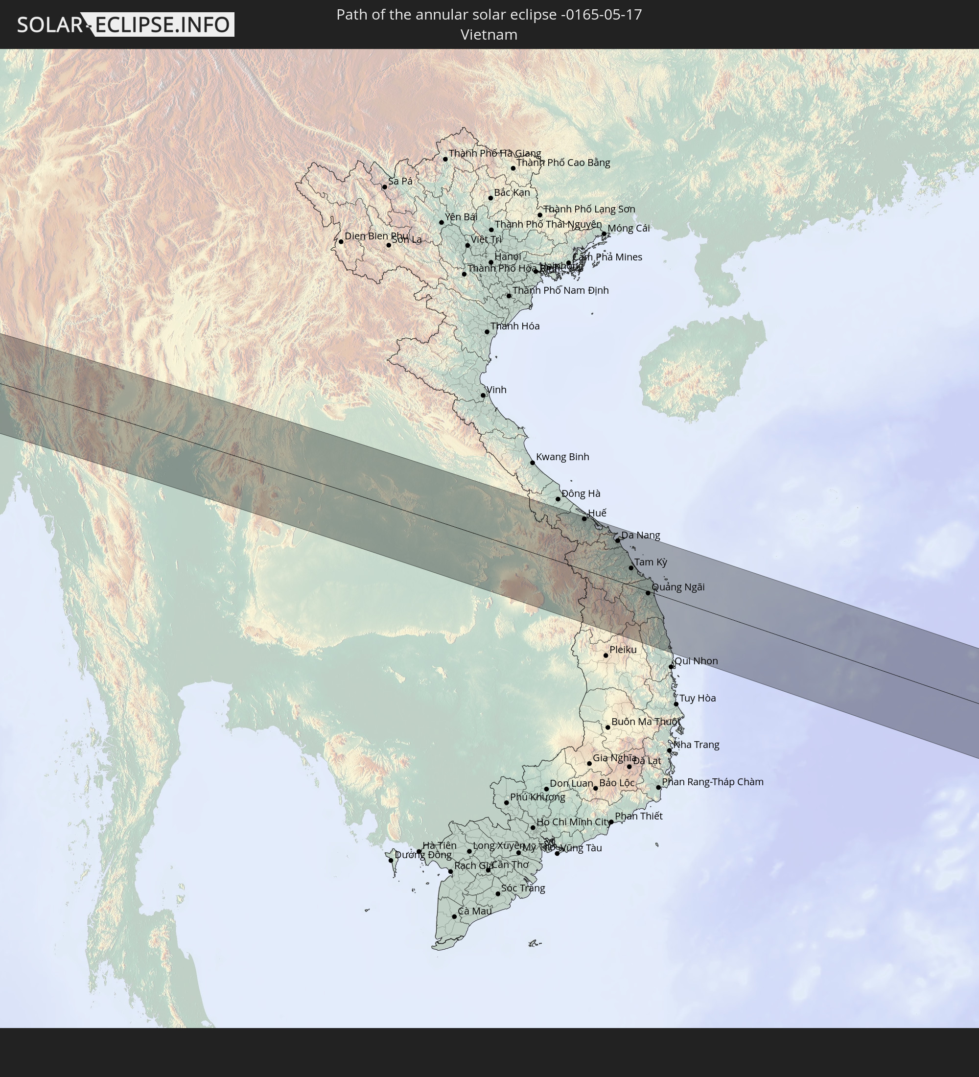 Vietnam
 Cambodia
 Philippines
In den folgenden Ländern ist die Sonnenfinsternis partiell zu sehen
 Russia
 Spain
Spain
 Senegal
 Mauritania
 The Gambia
 Guinea
 Sierra Leone
 Morocco
 Mali
Mali
 Liberia
 Algeria
 Ivory Coast
 Burkina Faso
 Ghana
Ghana
 Togo
Togo
 Niger
Niger
 Benin
Benin
 Nigeria
 Equatorial Guinea
 São Tomé and Príncipe
 Italy
Italy
 Tunisia
 Cameroon
 Gabon
Gabon
 Libya
Libya
 Republic of the Congo
 Angola
 Namibia
 Democratic Republic of the Congo
 Vatican City
 Chad
Chad
 Croatia
 Malta
Malta
 Central African Republic
 Bosnia and Herzegovina
 Hungary
 South Africa
 Montenegro
 Serbia
 Albania
 Greece
 Botswana
 Romania
 Republic of Macedonia
 Sudan
Sudan
 Zambia
 Ukraine
 Bulgaria
 Egypt
Egypt
 Zimbabwe
 Turkey
 Moldova
 Lesotho
 Rwanda
 Burundi
 Tanzania
 Uganda
 Mozambique
 Swaziland
 Cyprus
 Malawi
 Ethiopia
 Kenya
Kenya
 State of Palestine
 Israel
 Saudi Arabia
 Jordan
 Lebanon
 Syria
Syria
 Eritrea
 Iraq
Iraq
 Georgia
 French Southern and Antarctic Lands
 Somalia
 Djibouti
 Yemen
Yemen
 Madagascar
 Comoros
 Armenia
 Iran
Iran
 Azerbaijan
 Mayotte
 Seychelles
 Kazakhstan
 Kuwait
 Bahrain
 Qatar
Qatar
 United Arab Emirates
 Oman
Oman
 Turkmenistan
 Uzbekistan
 Mauritius
 Afghanistan
 Pakistan
 Tajikistan
 India
India
 Kyrgyzstan
 British Indian Ocean Territory
 Maldives
 China
China
 Sri Lanka
 Nepal
Nepal
 Mongolia
 Bangladesh
 Bhutan
 Myanmar
 Indonesia
 Cocos Islands
 Thailand
 Malaysia
 Laos
Laos
 Vietnam
 Cambodia
 Singapore
 Christmas Island
 Macau
Macau
 Hong Kong
 Brunei
 Taiwan
 Philippines
 Japan
Japan
 North Korea
 South Korea
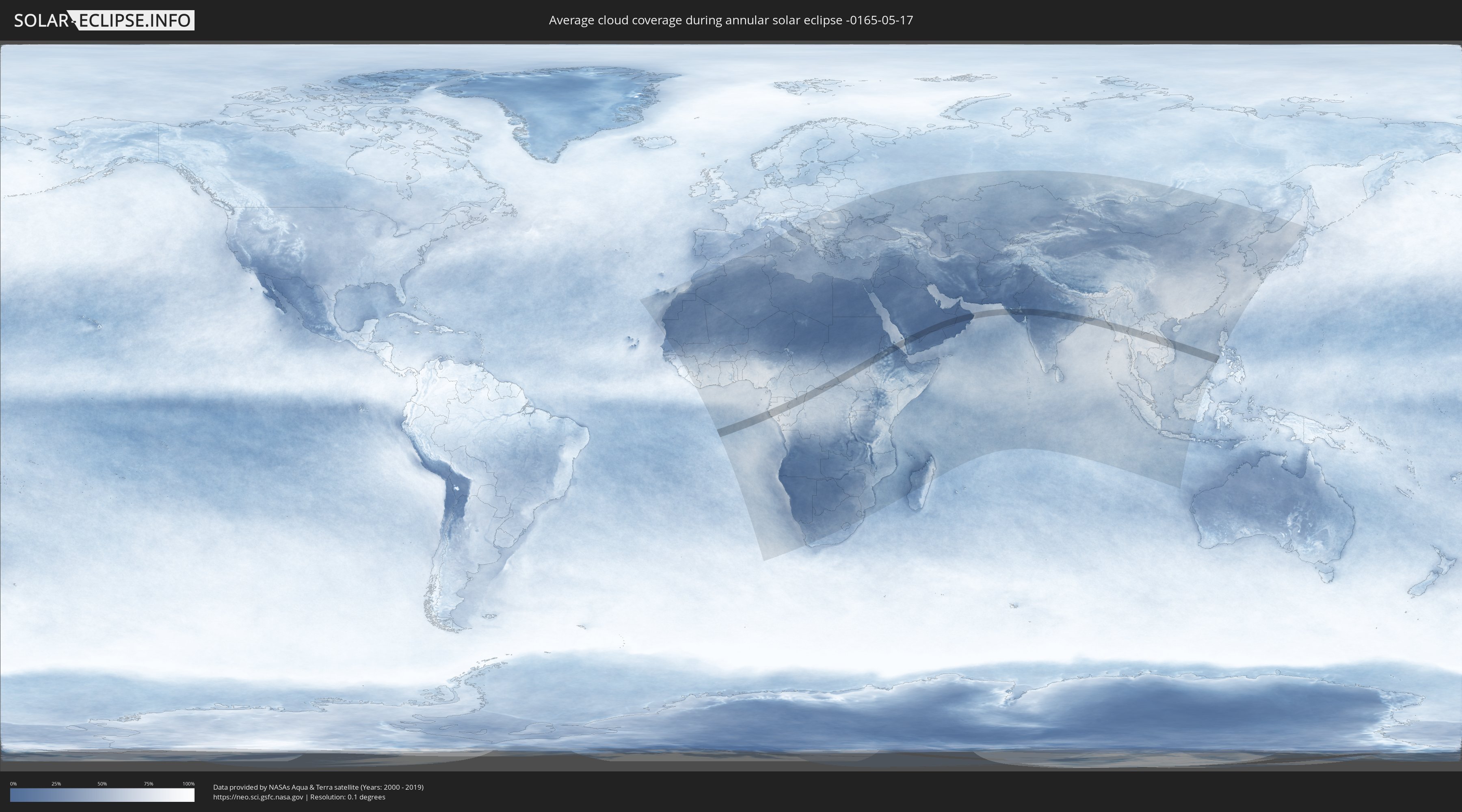
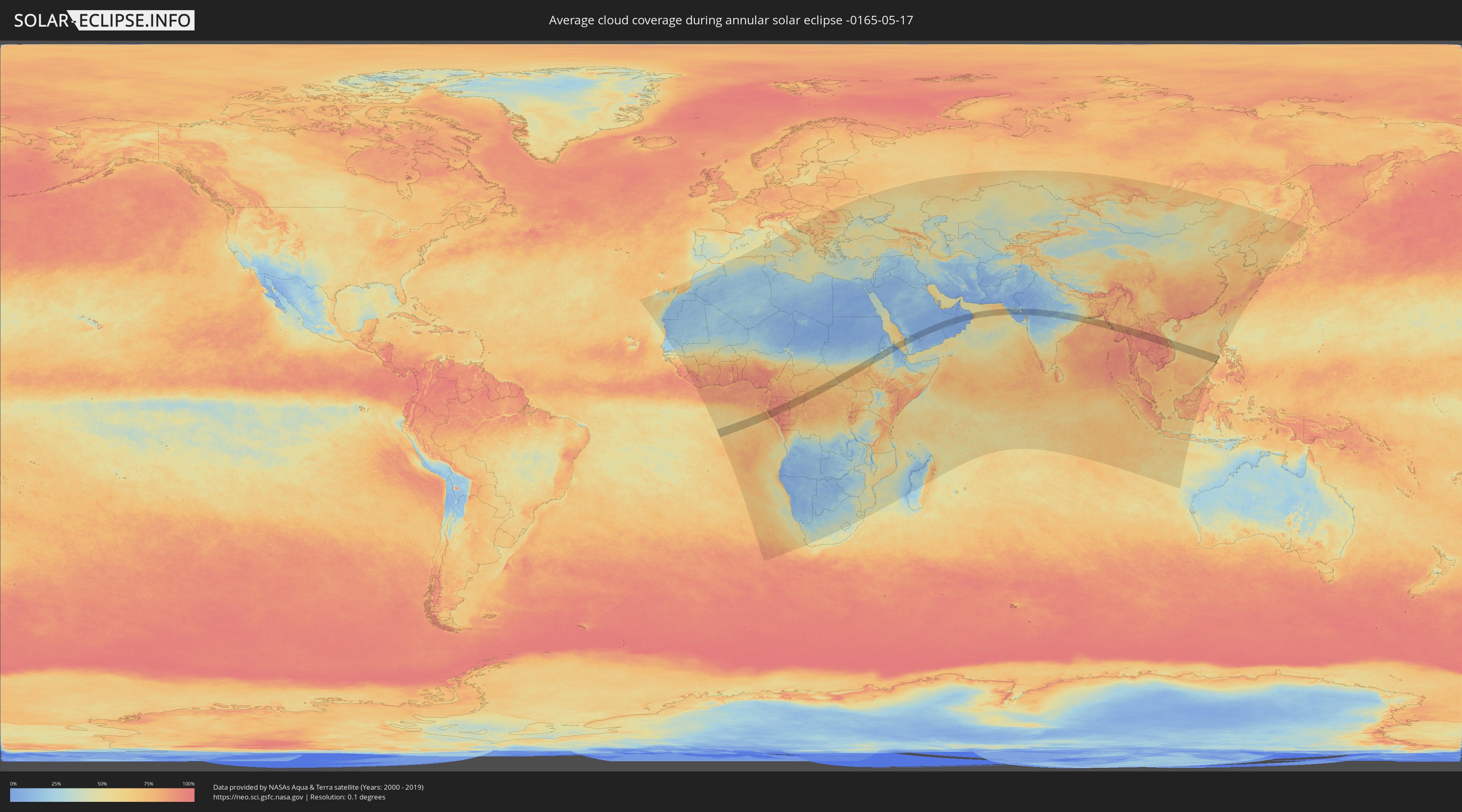
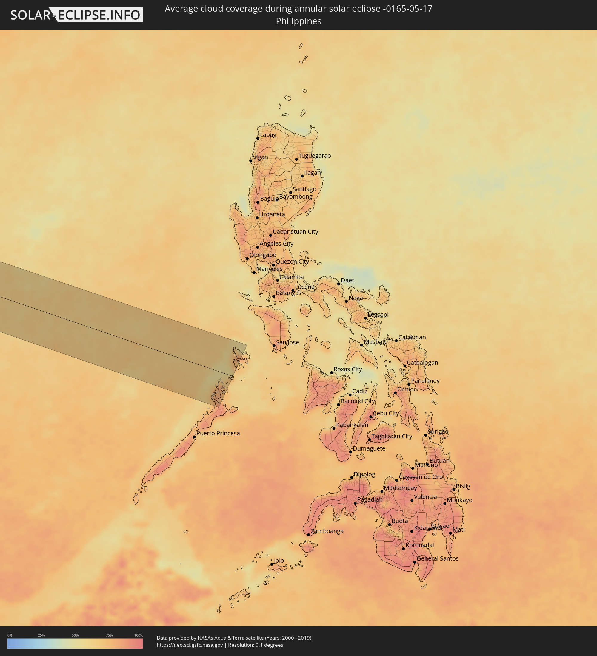
How will be the weather during the annular solar eclipse on 05/17/-0165?
Where is the best place to see the annular solar eclipse of 05/17/-0165?
The following maps show the average cloud coverage for the day of the annular solar eclipse.
With the help of these maps, it is possible to find the place along the eclipse path, which has the best
chance of a cloudless sky.
Nevertheless, you should consider local circumstances and inform about the weather of your chosen
observation site.
The data is provided by NASAs satellites
AQUA and TERRA.
The cloud maps are averaged over a period of 19 years (2000 - 2019).
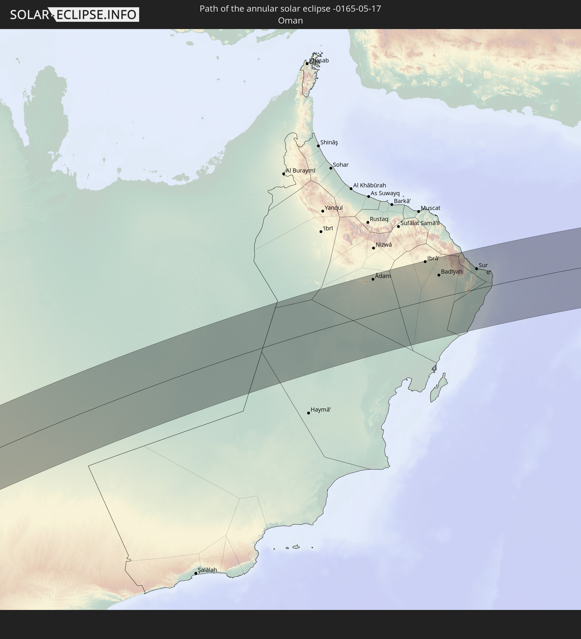
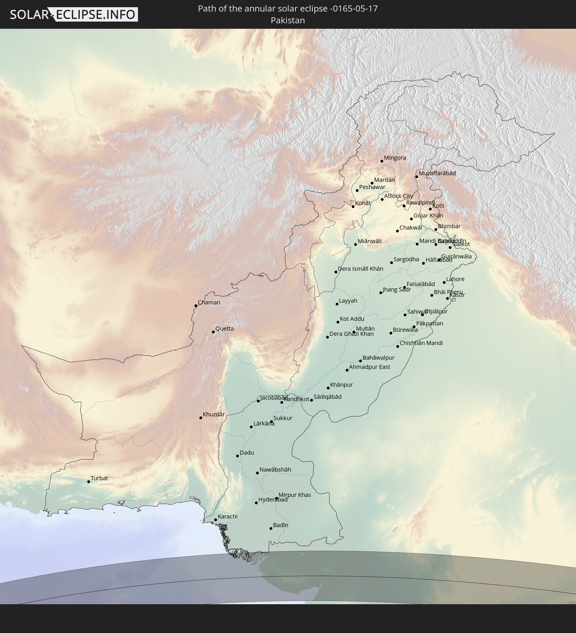
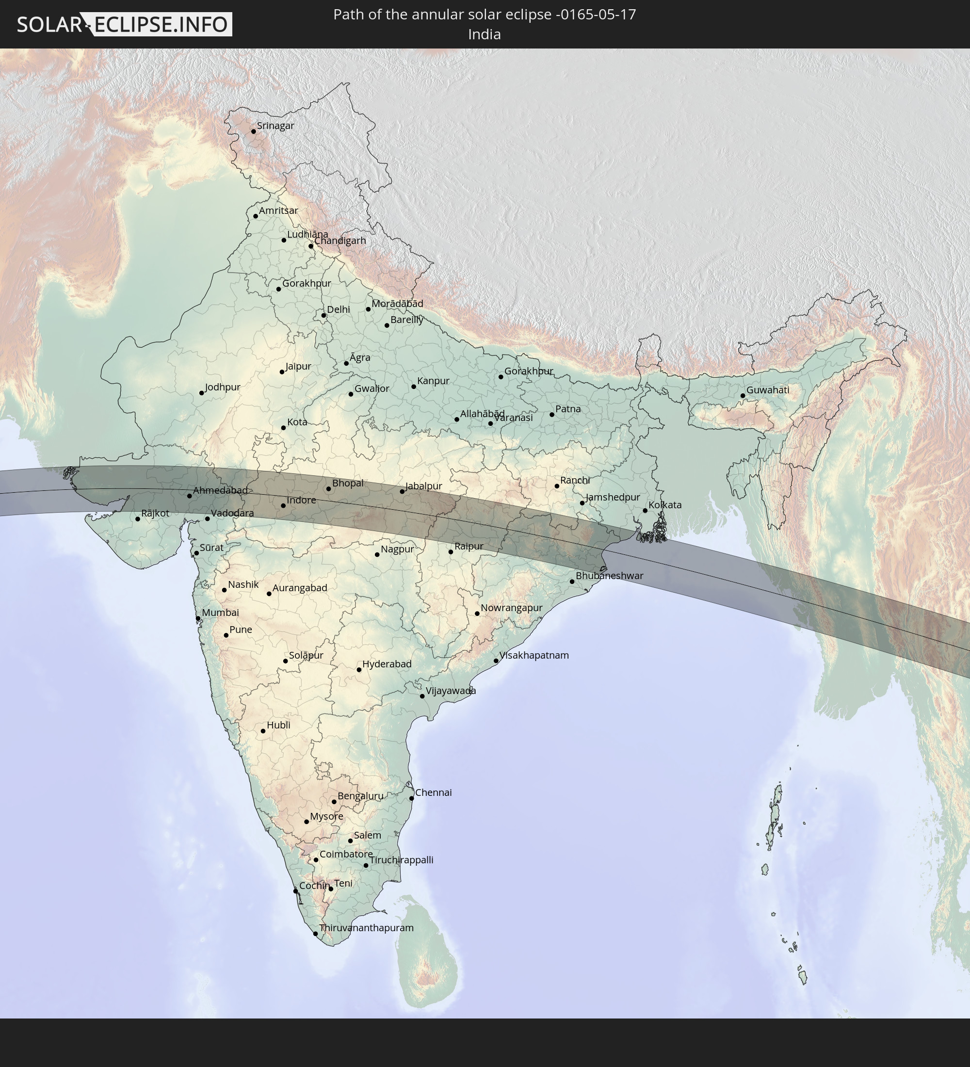
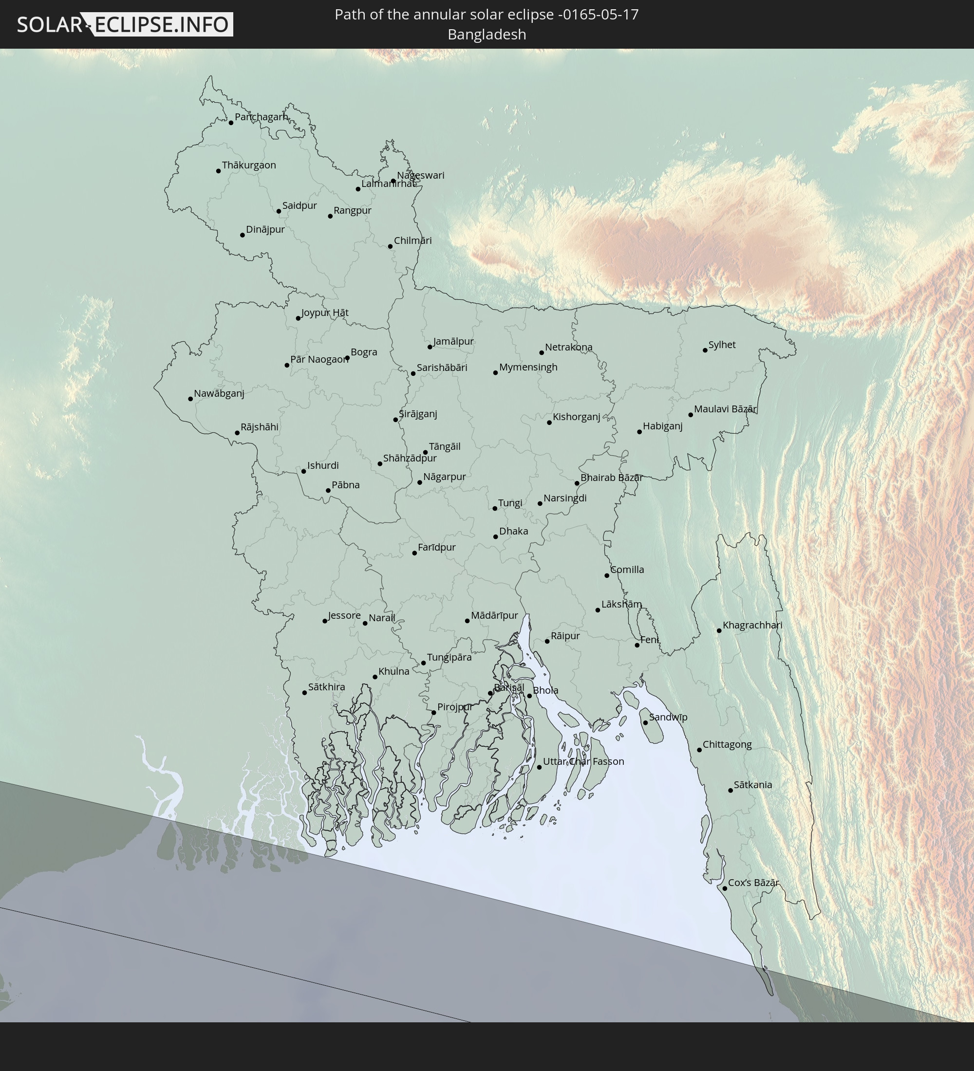
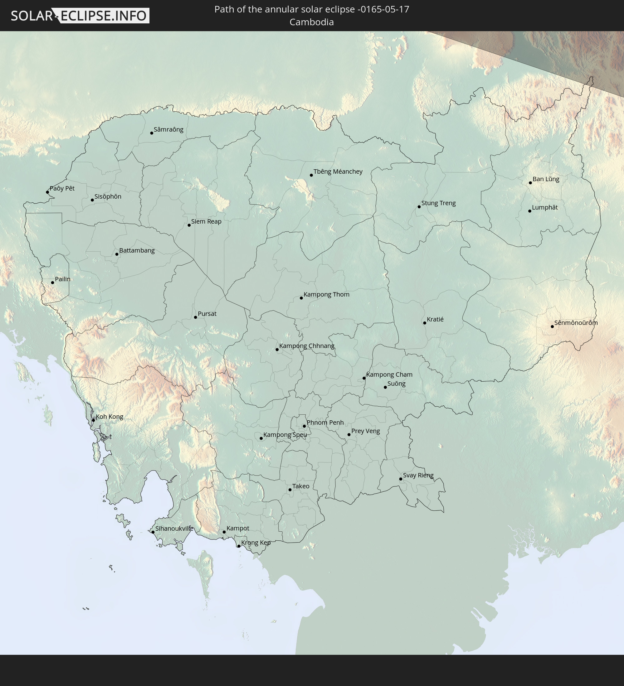
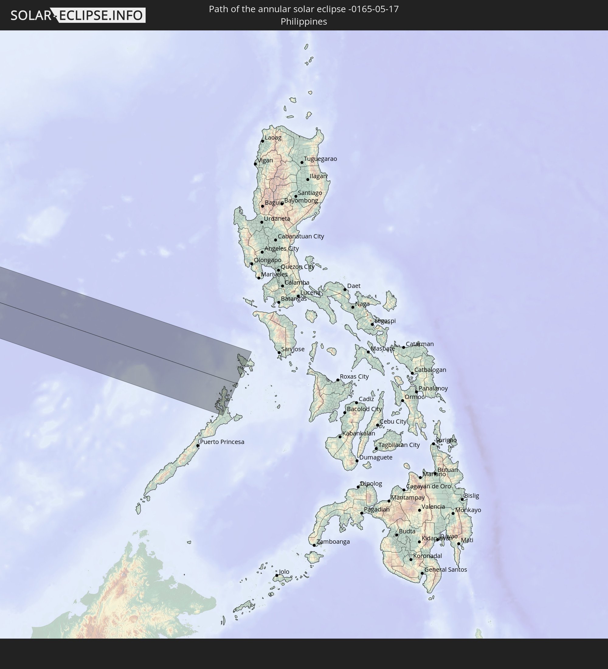
Detailed country maps
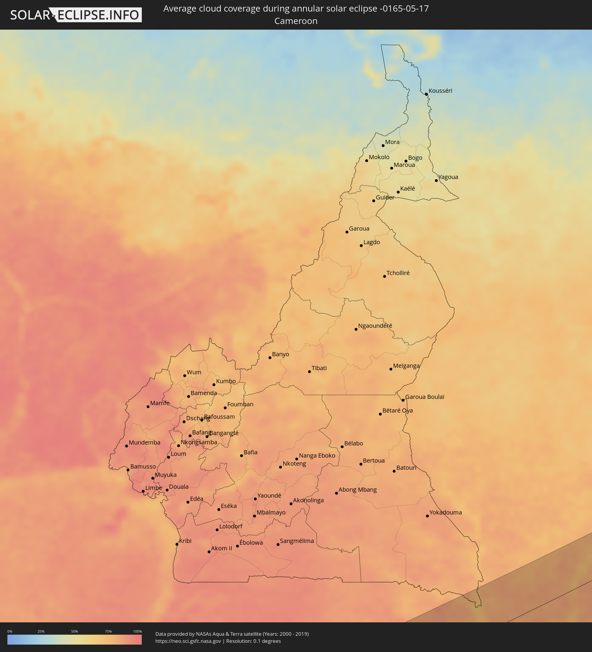 Cameroon
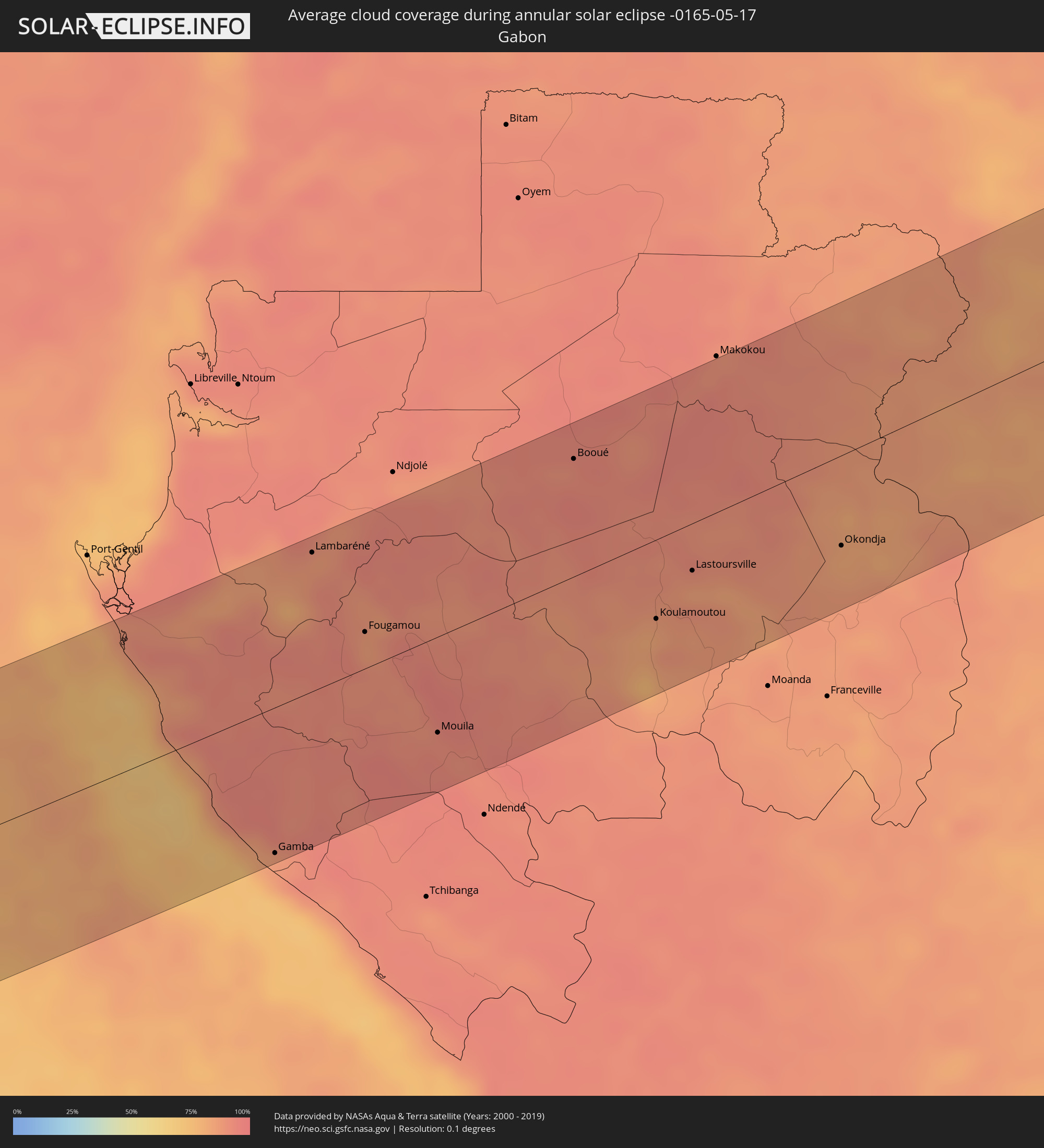 Gabon
Gabon
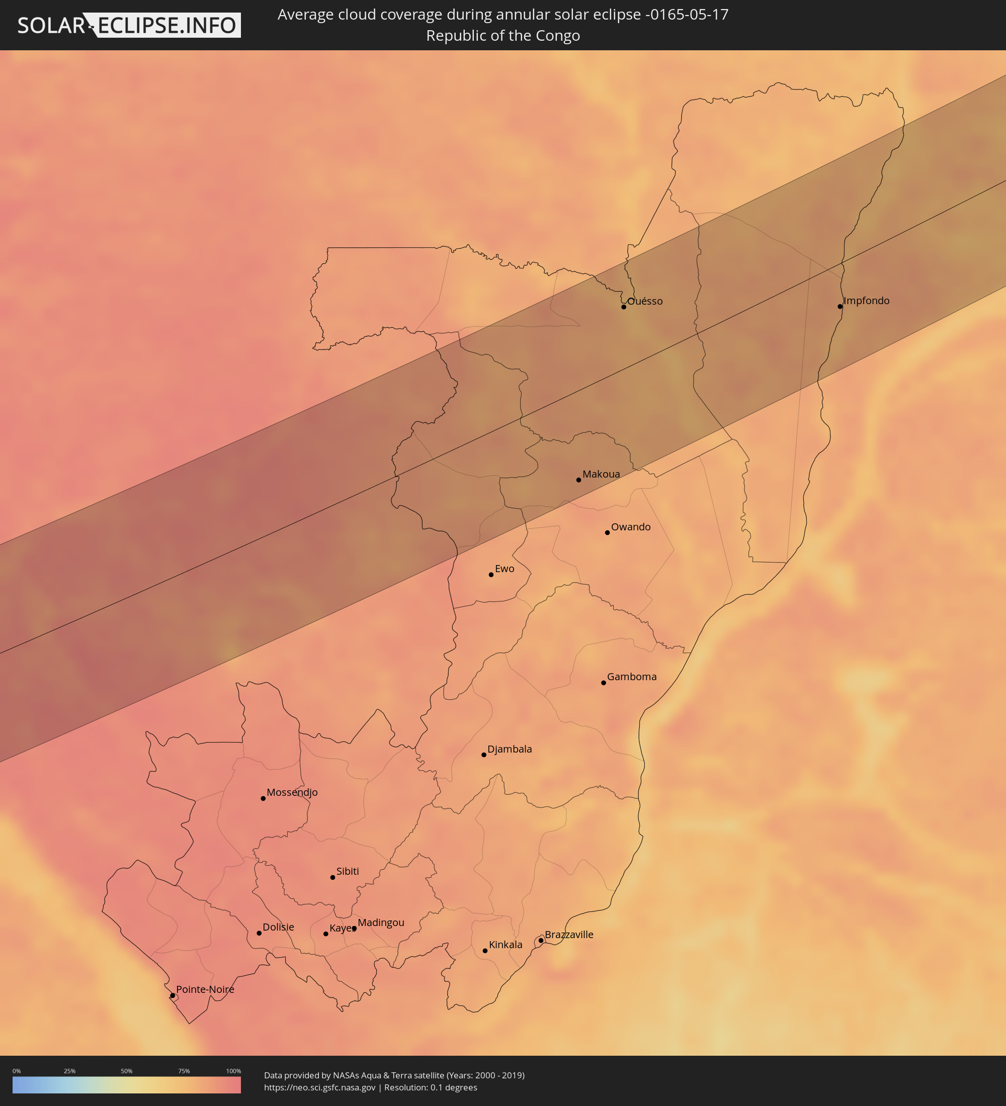 Republic of the Congo
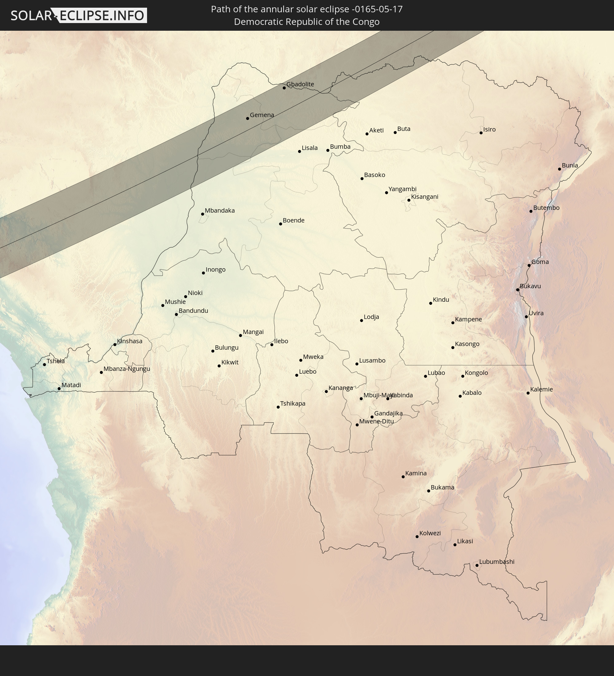
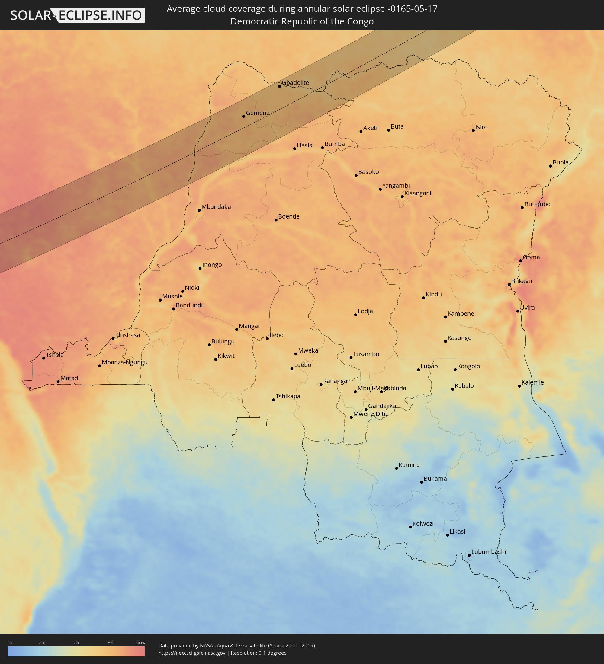 Democratic Republic of the Congo
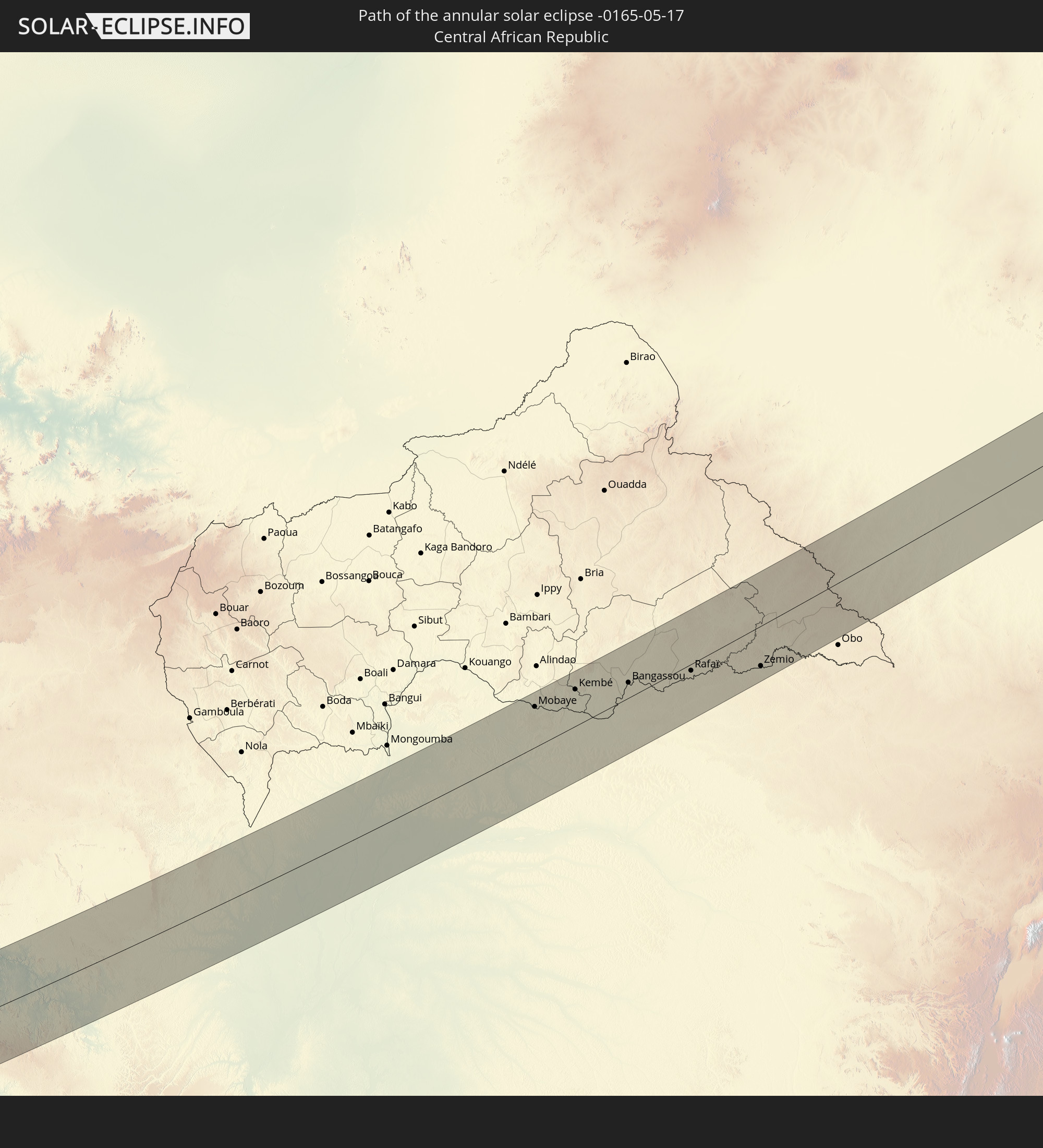
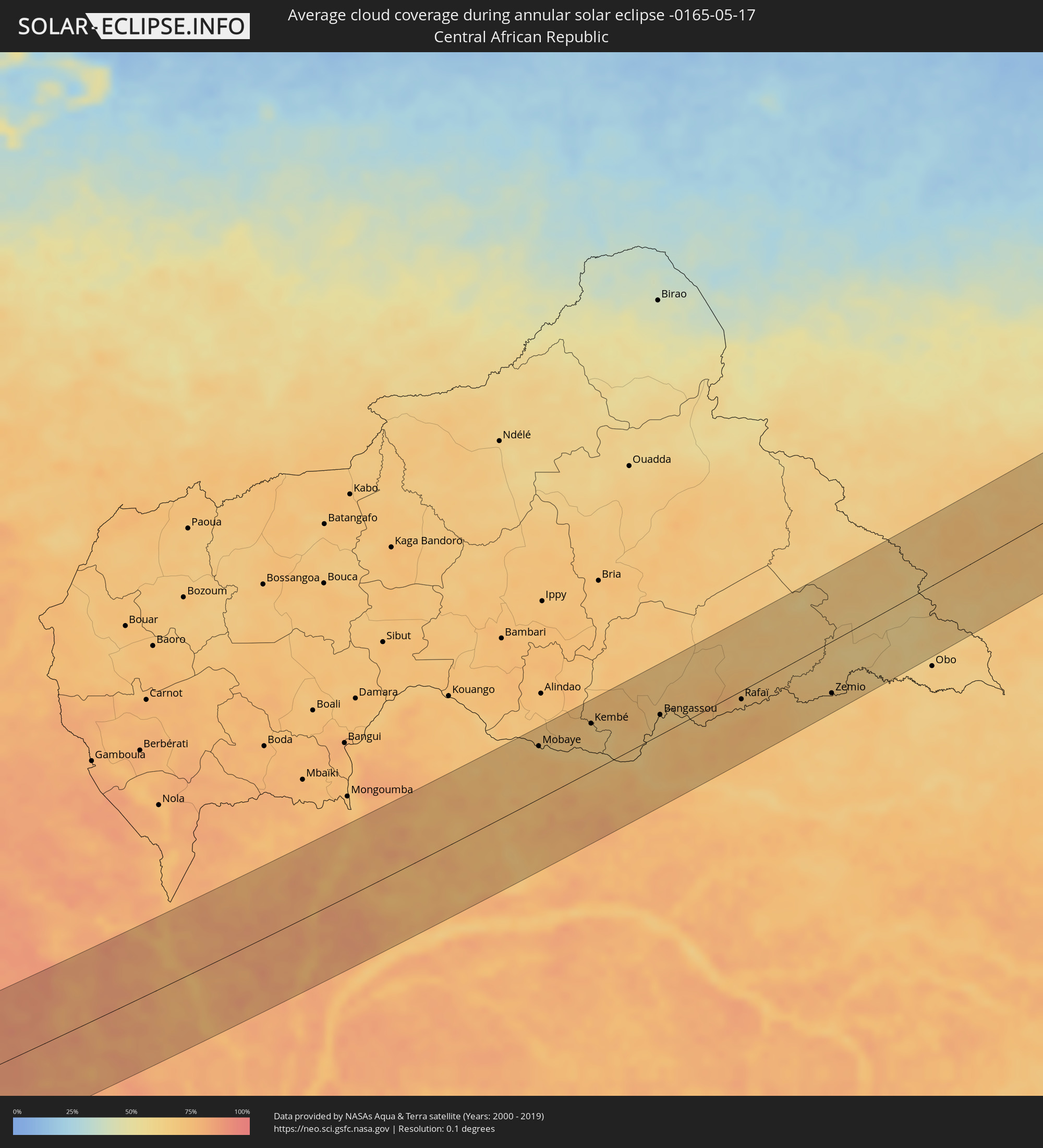 Central African Republic
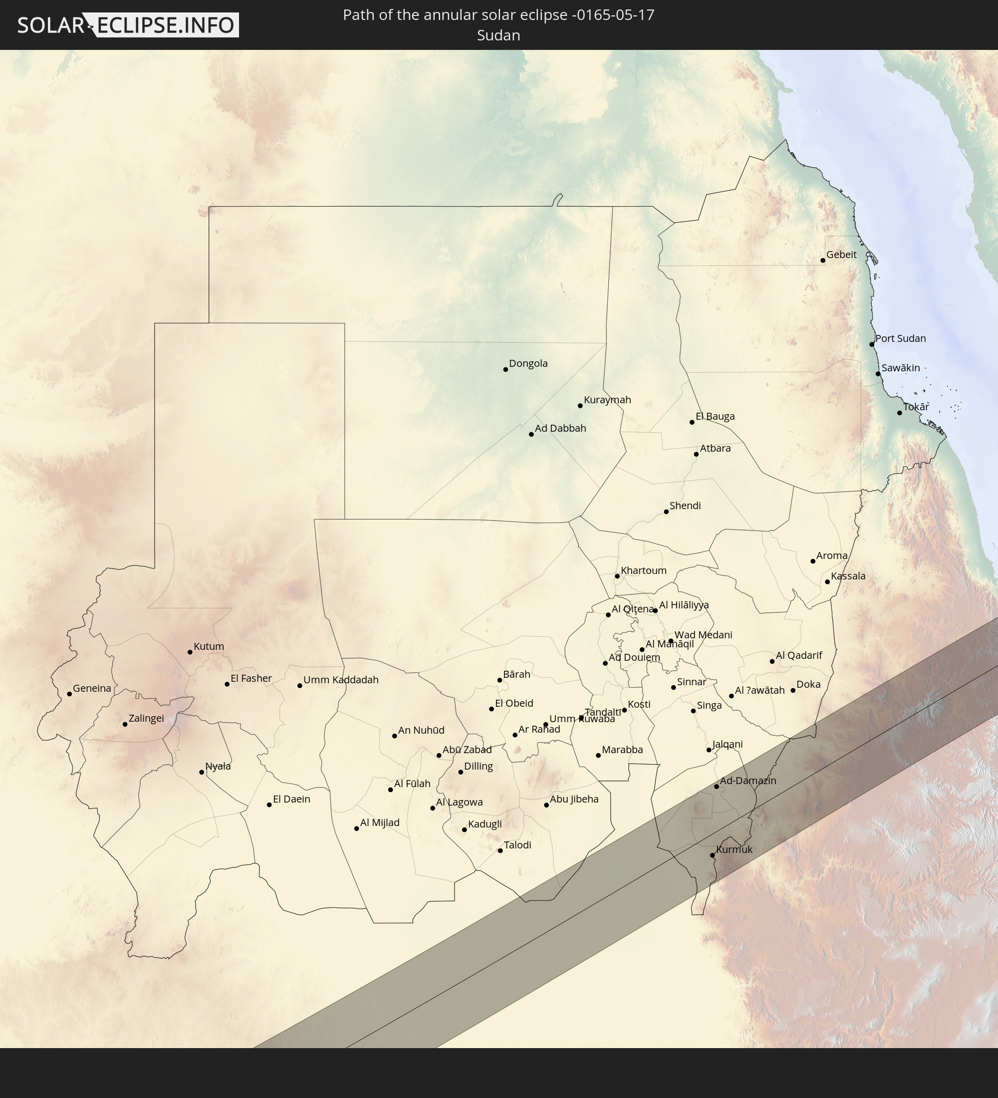
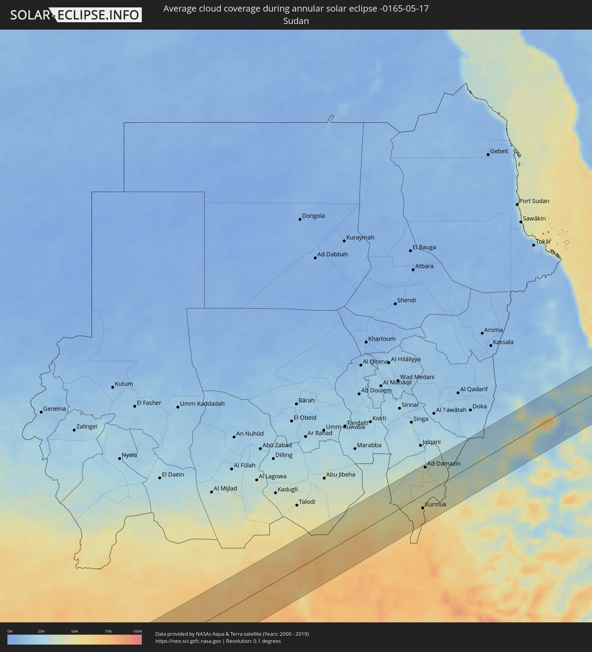 Sudan
Sudan
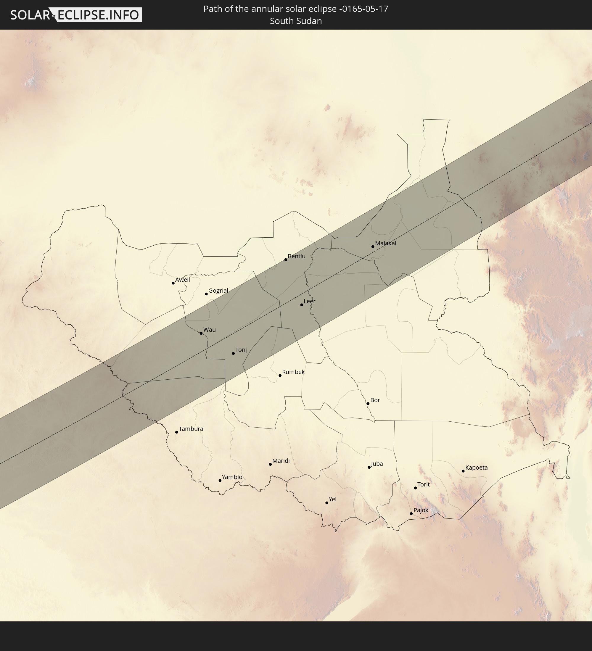
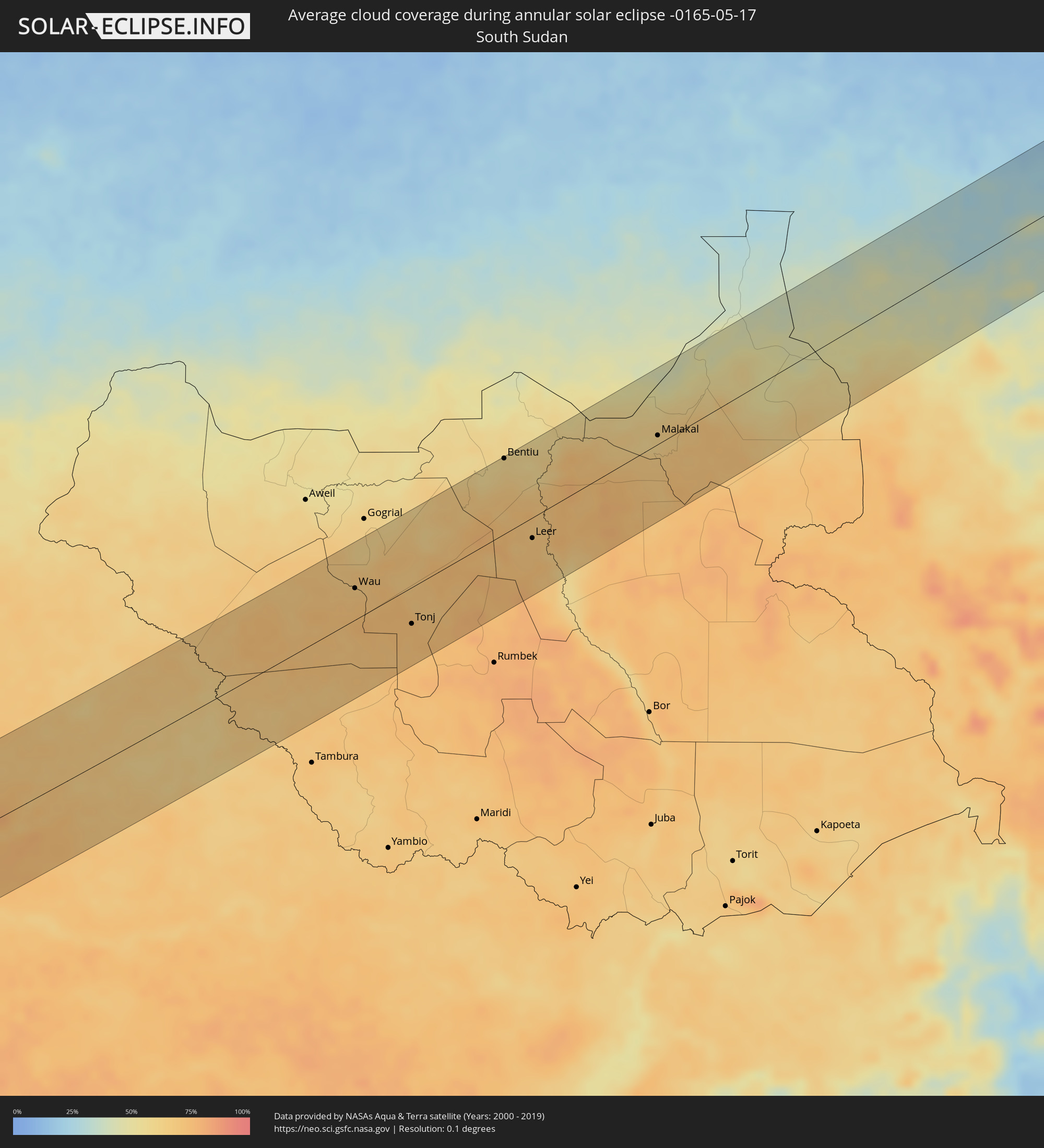 South Sudan
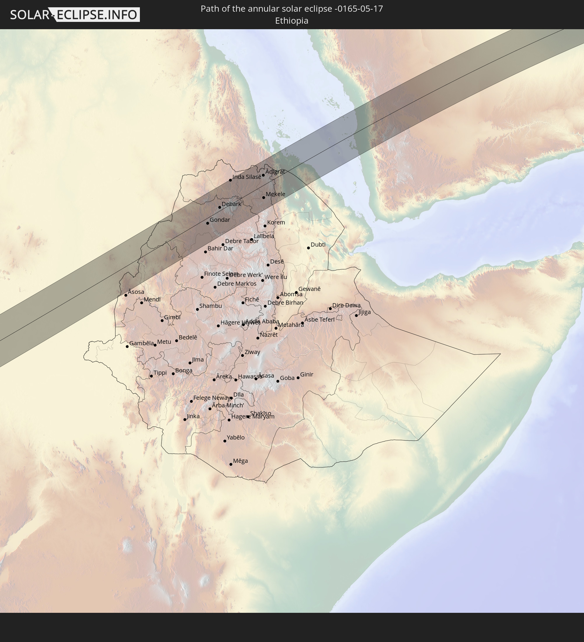
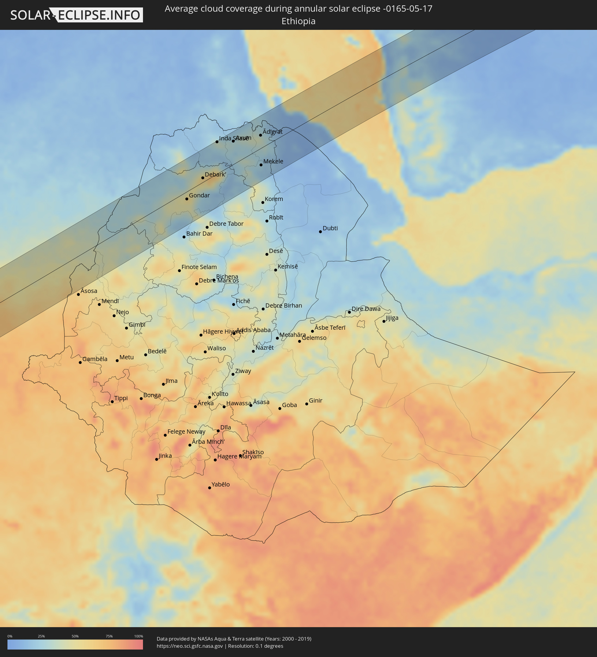 Ethiopia
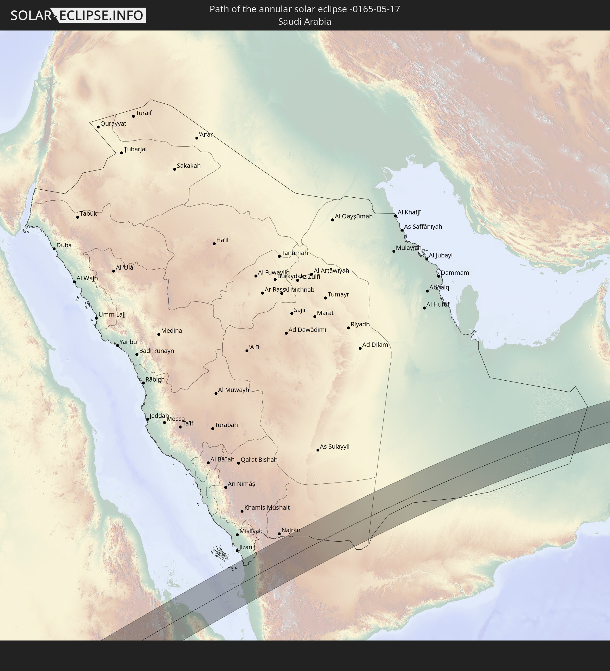
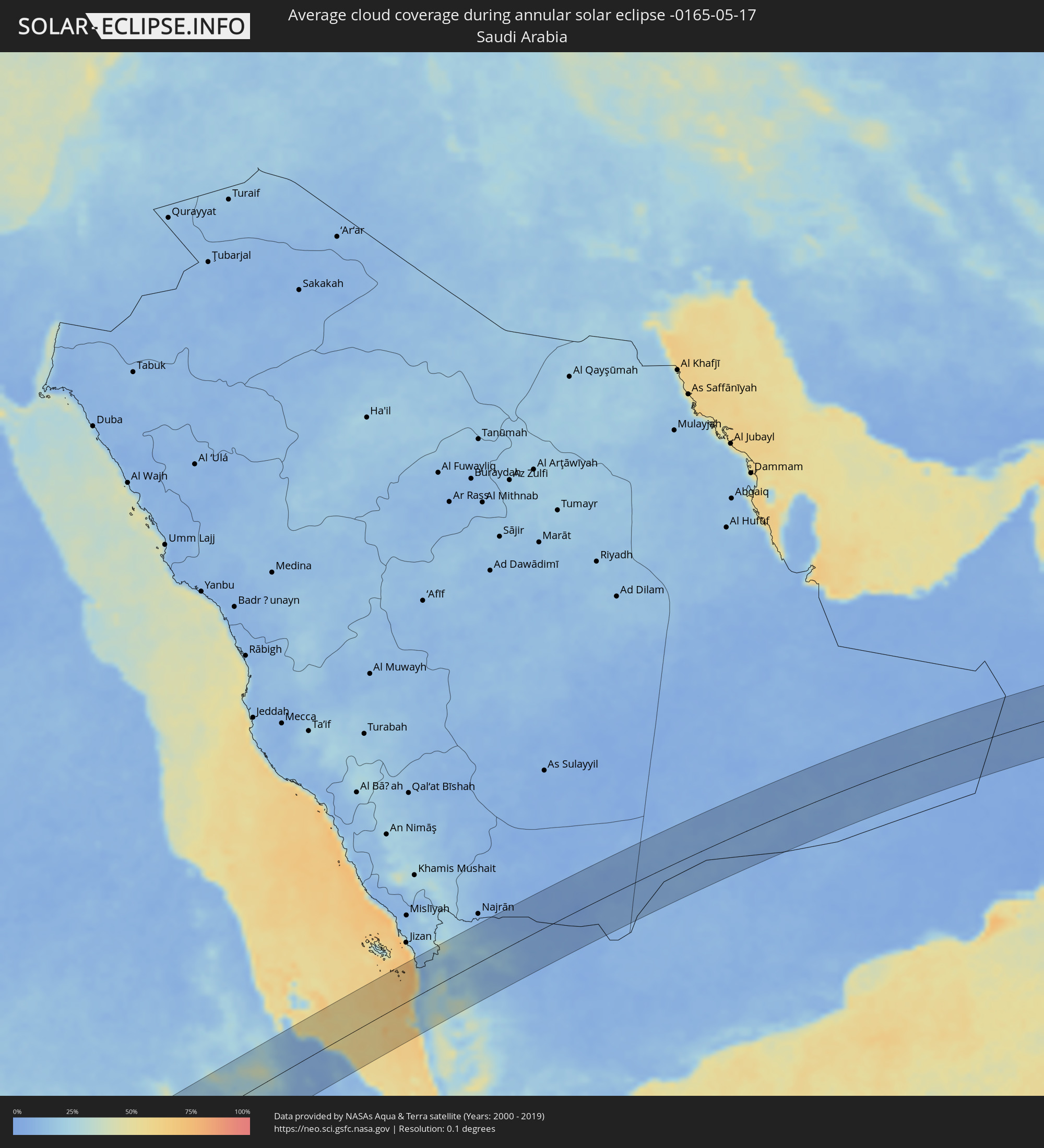 Saudi Arabia
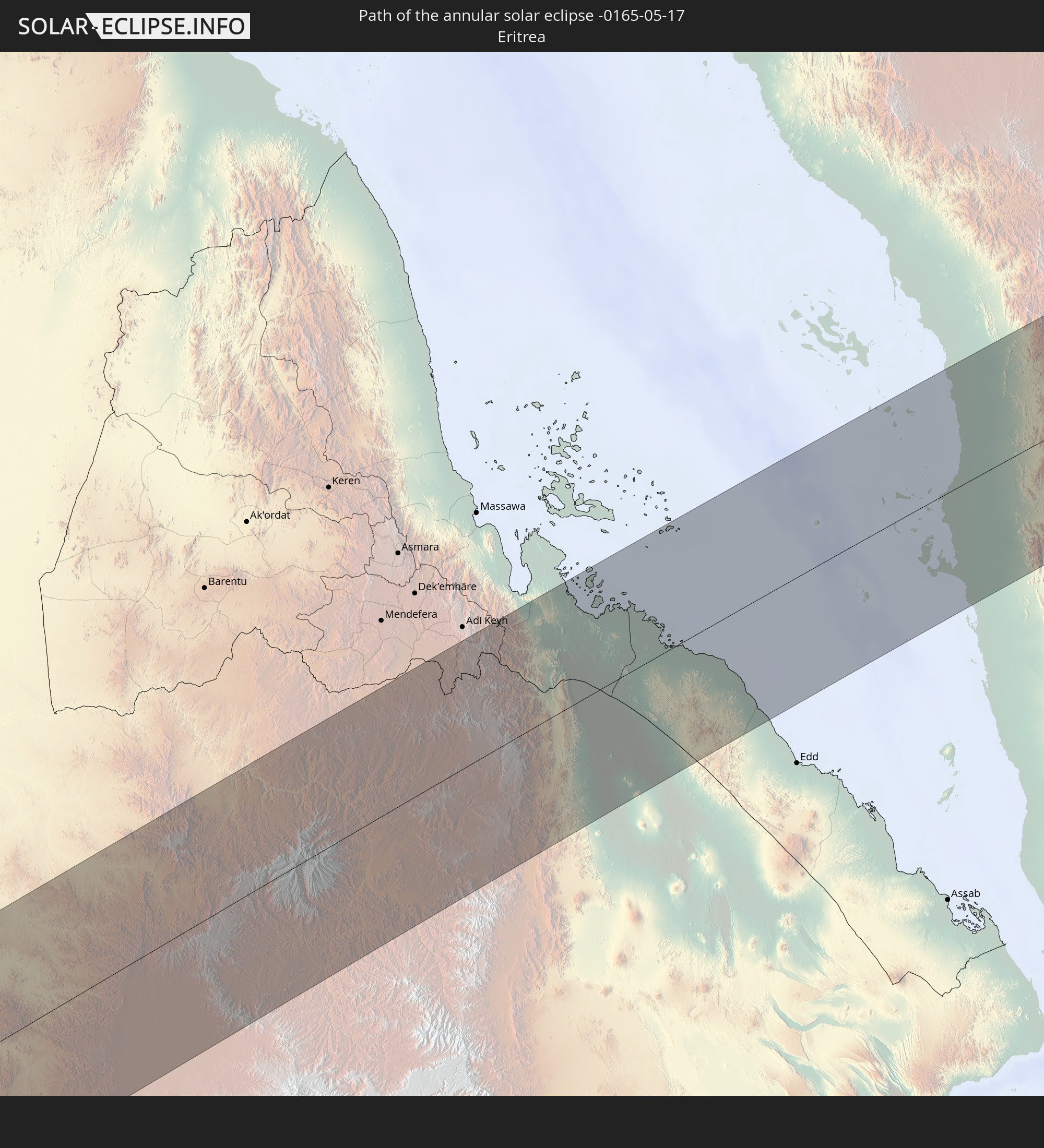
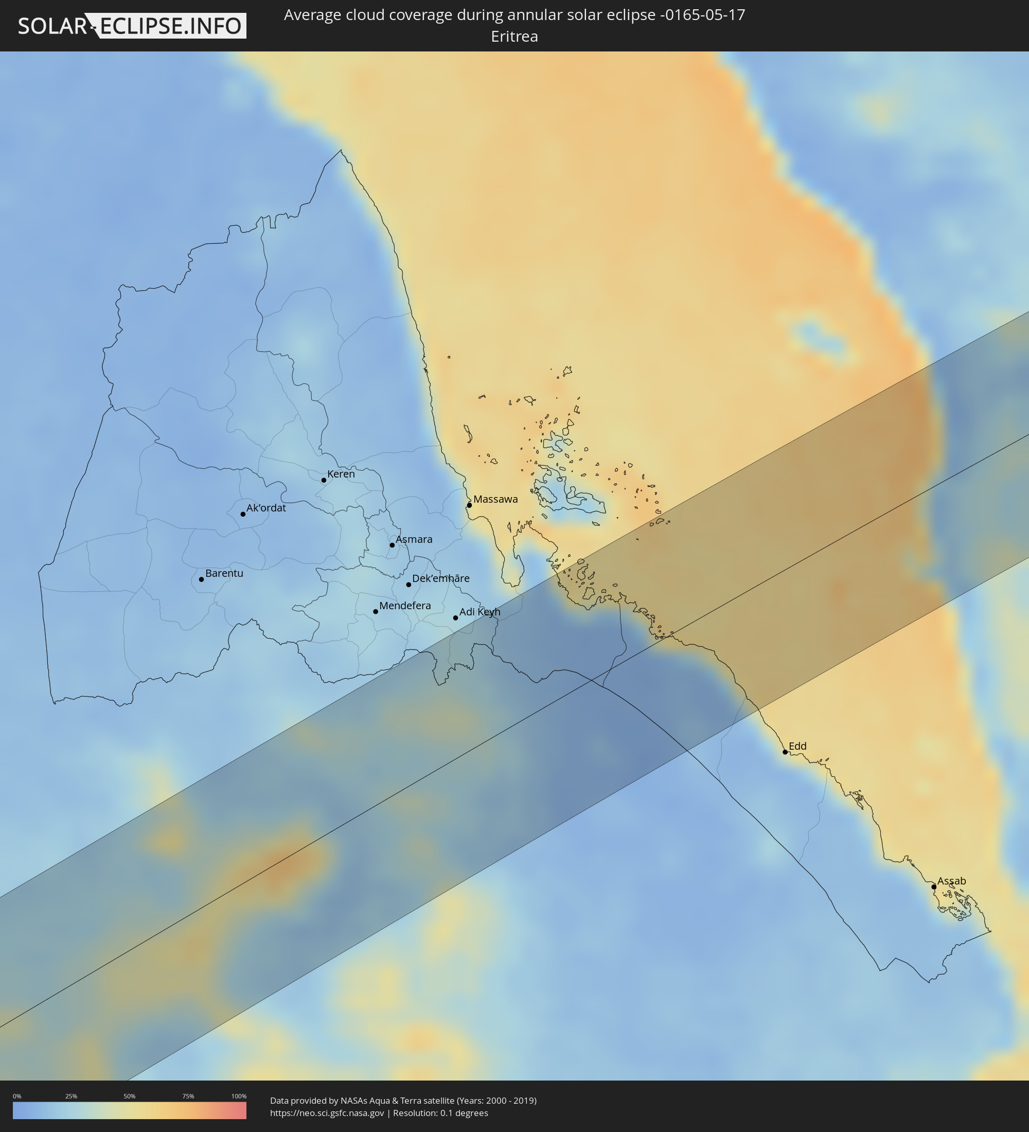 Eritrea
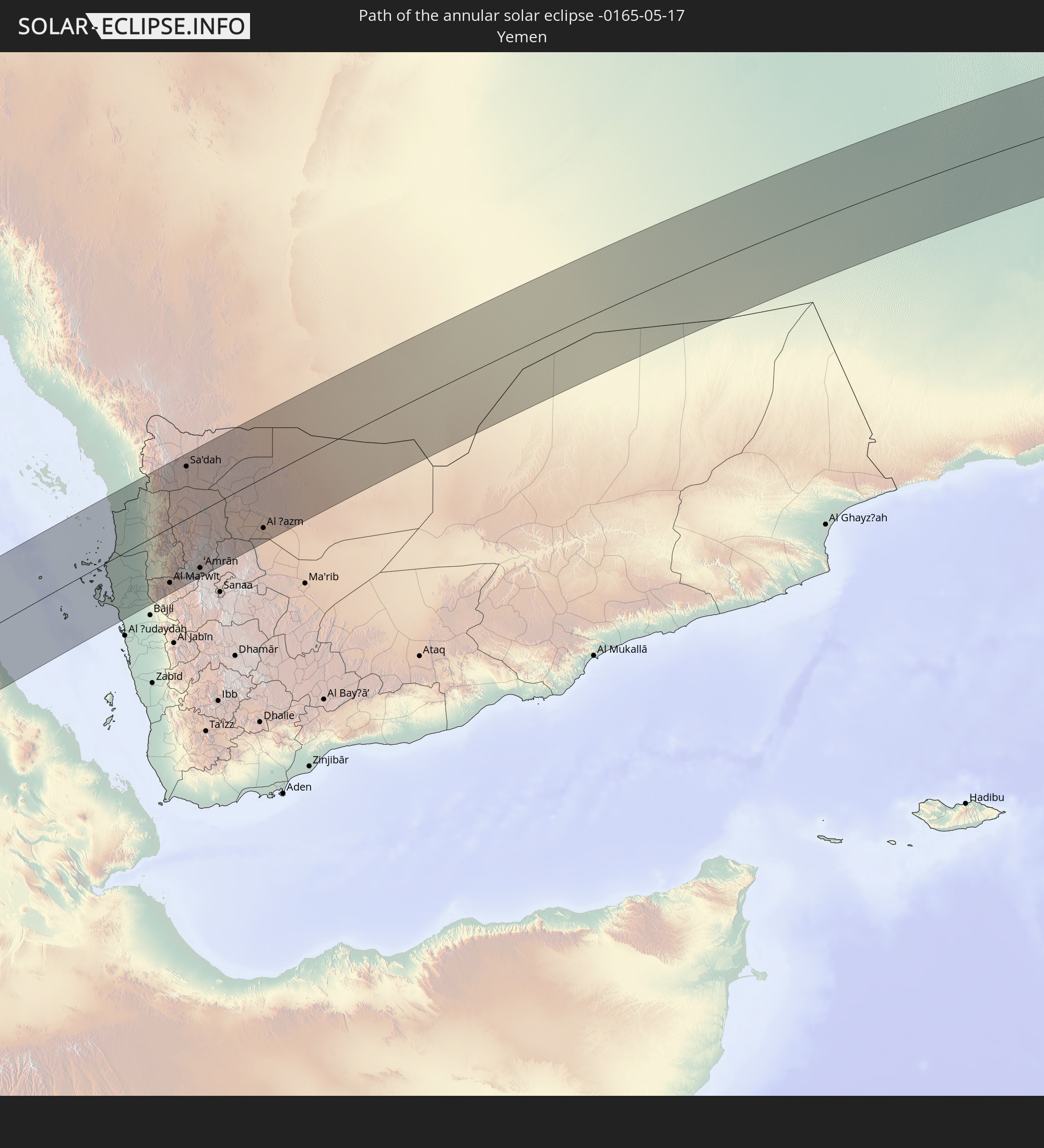
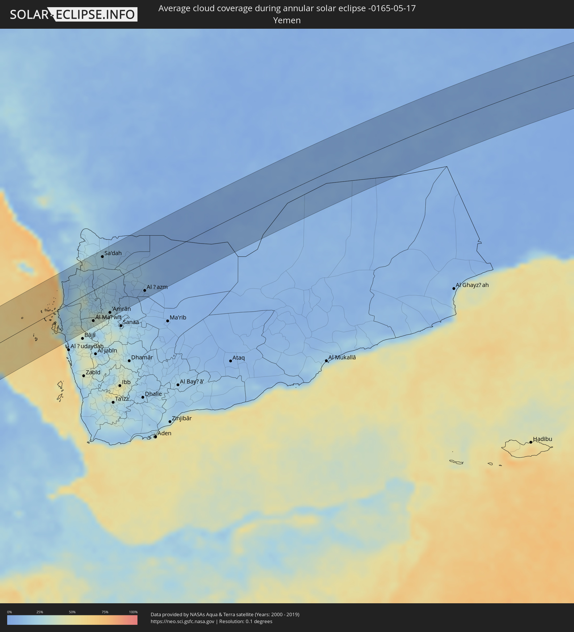 Yemen
Yemen
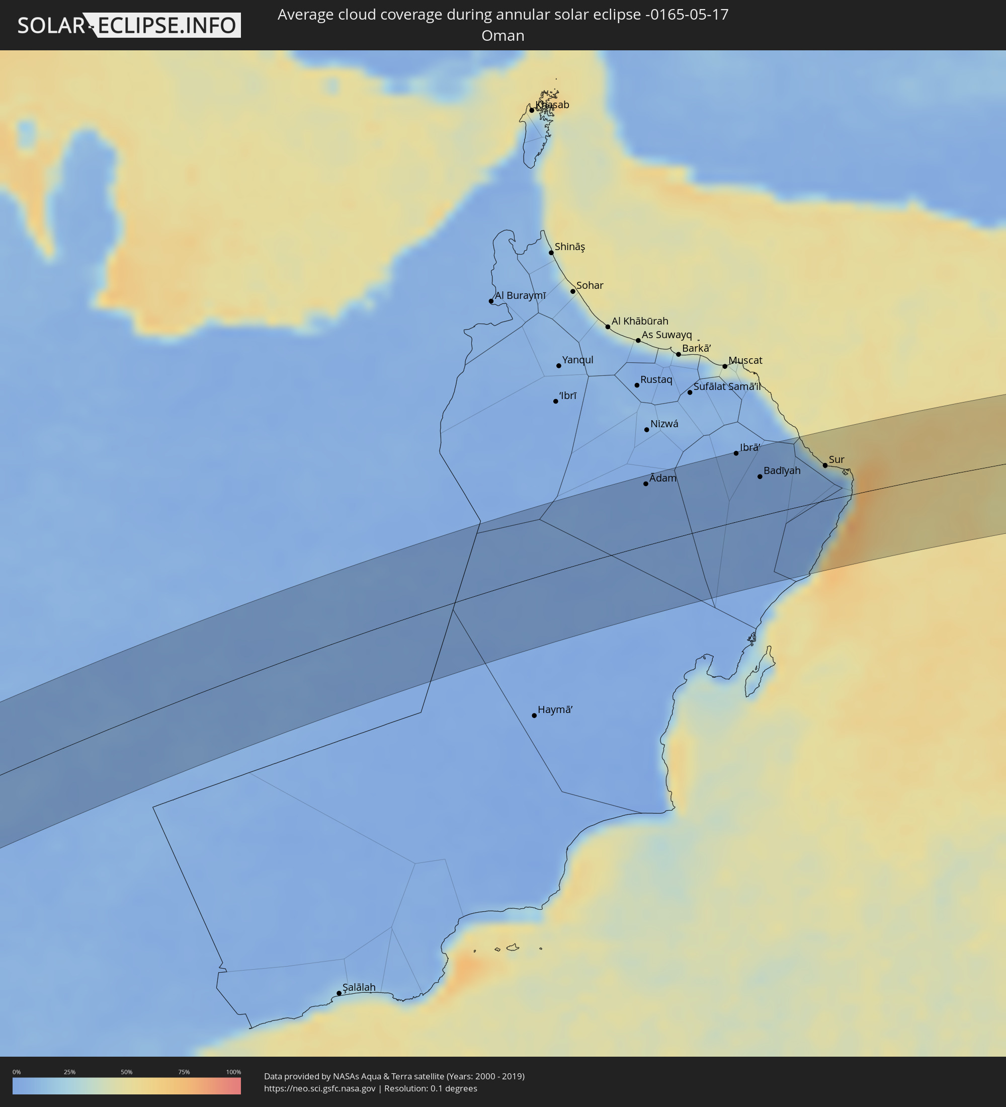 Oman
Oman
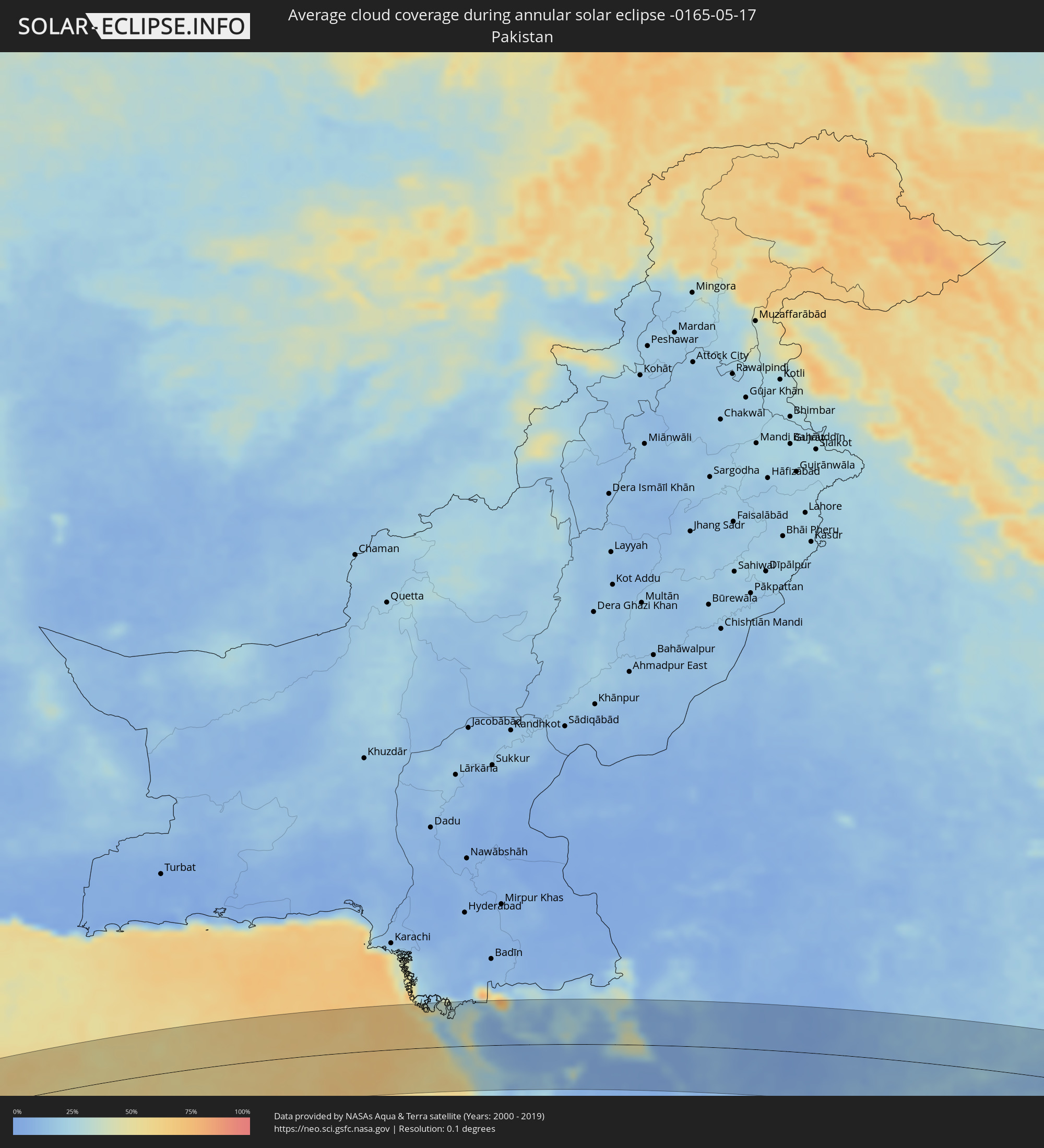 Pakistan
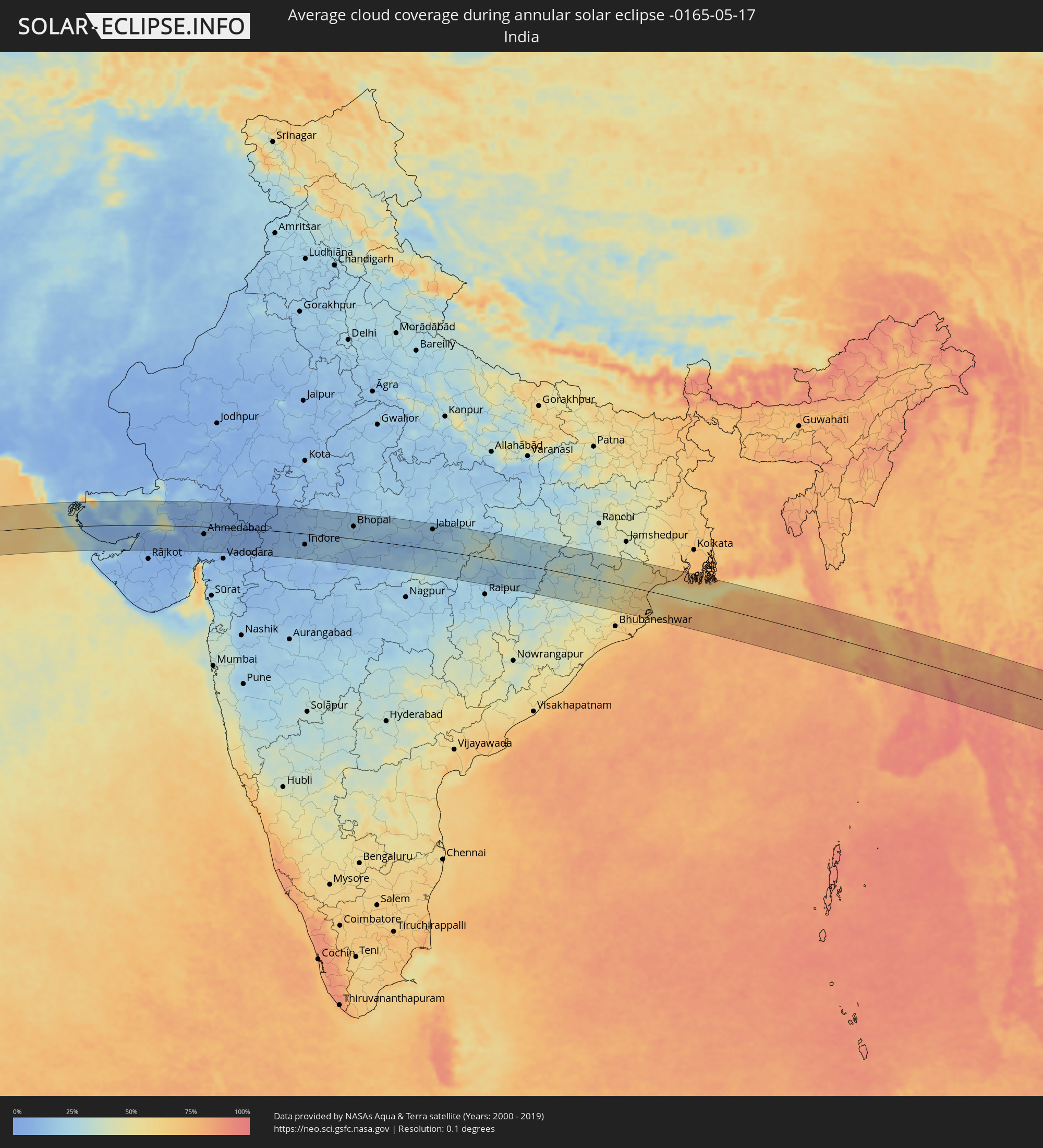 India
India
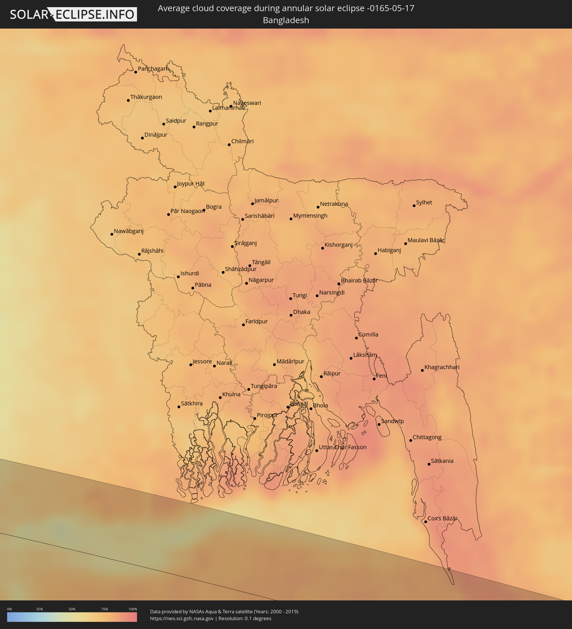 Bangladesh
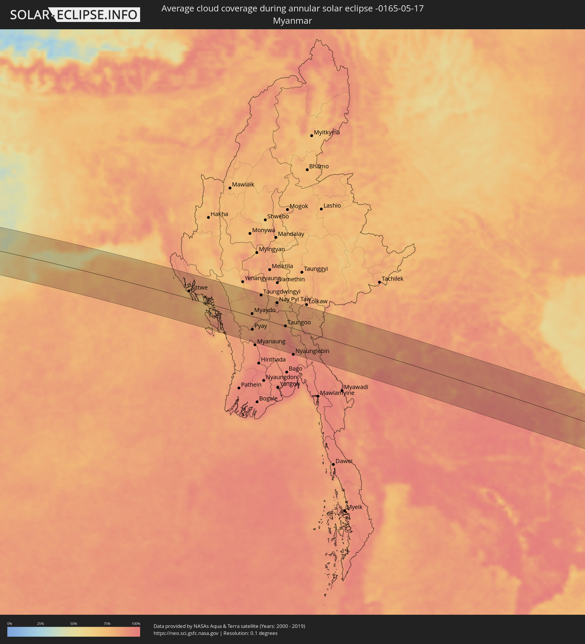 Myanmar
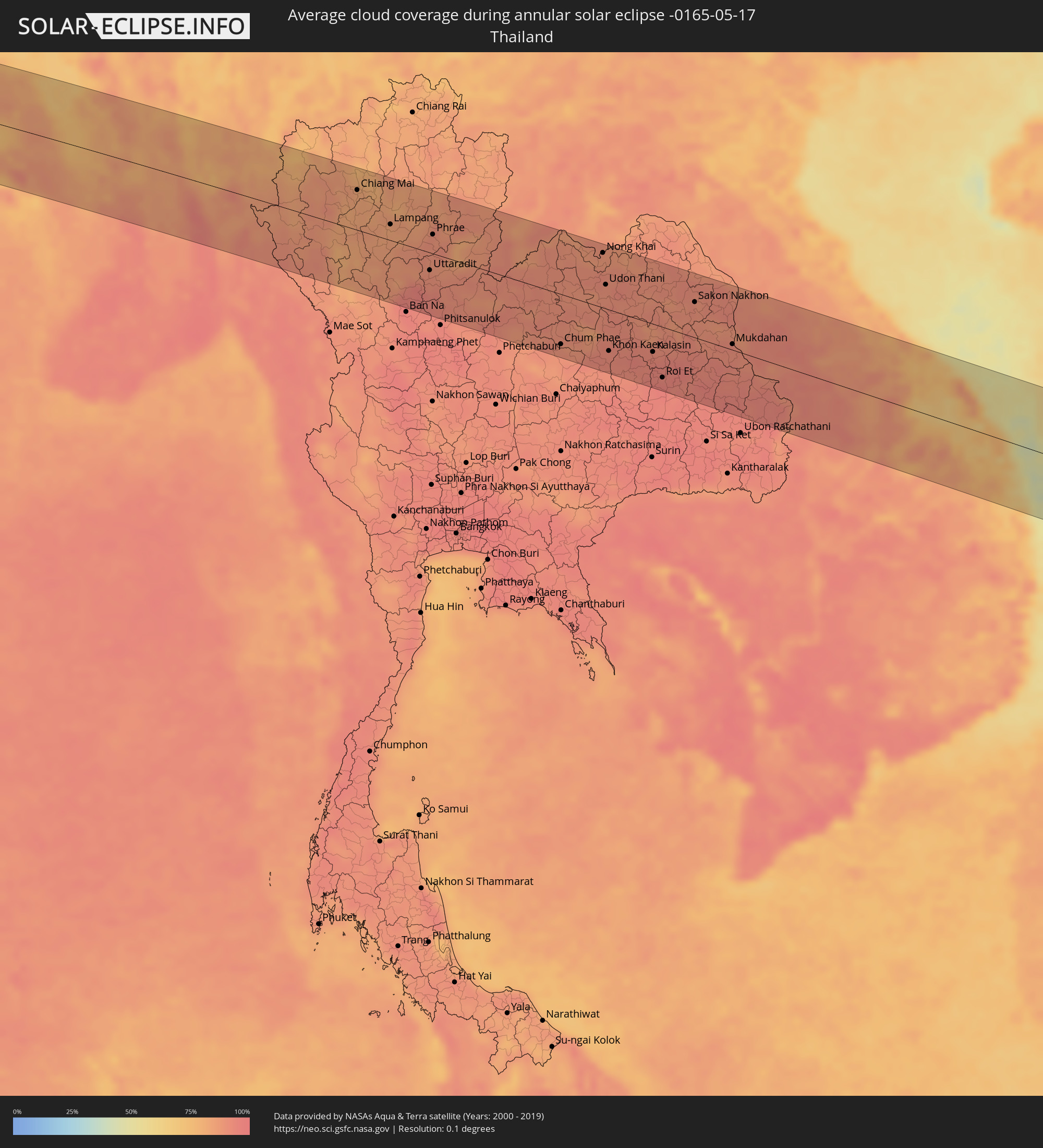 Thailand
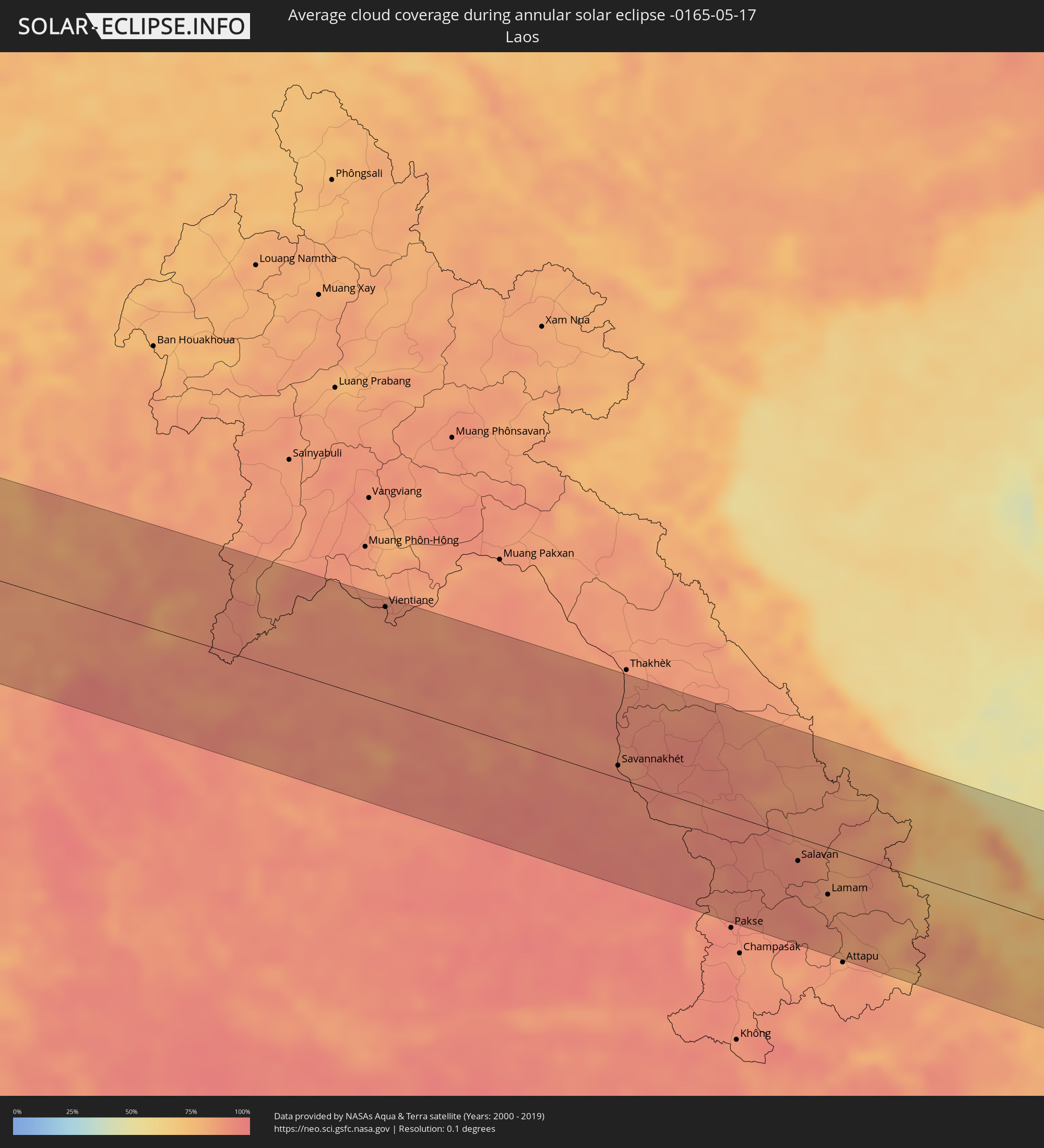 Laos
Laos
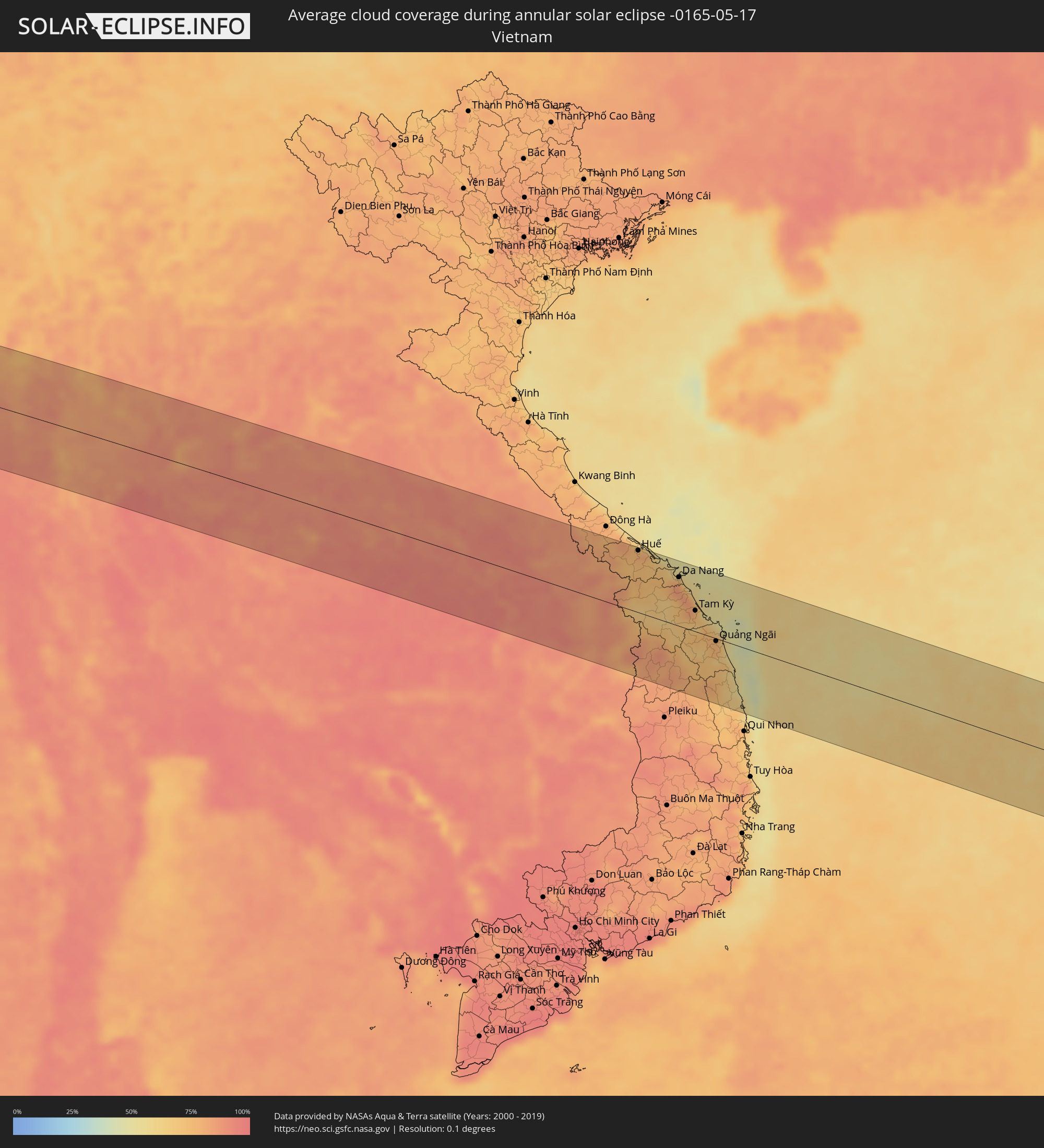 Vietnam
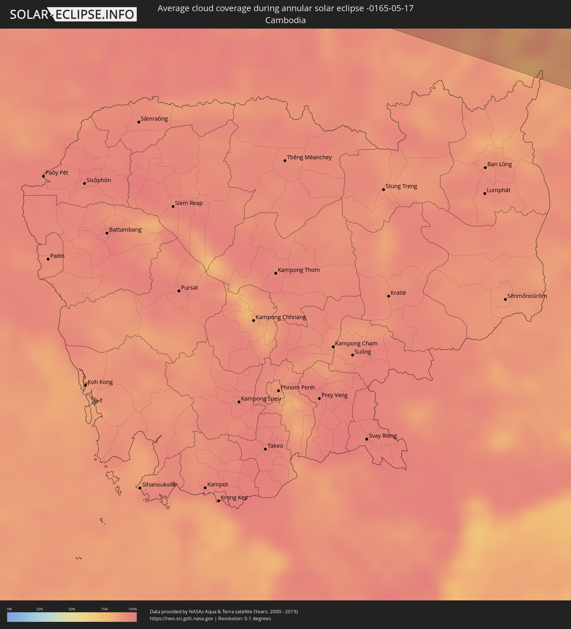 Cambodia
 Philippines
Cities inside the path of the eclipse
The following table shows all locations with a population of more than 5,000 inside the eclipse path. Cities which have more than 100,000 inhabitants are marked bold. A click at the locations opens a detailed map.
| City | Type | Eclipse duration | Local time of max. eclipse | Distance to central line | Ø Cloud coverage |
|
Gamba, Ogooué-Maritime
|
annular | - | 06:30:50 UTC+00:13 | 97 km | 82% |
|
Lambaréné, Moyen-Ogooué
|
annular | - | 06:32:18 UTC+00:13 | 92 km | 86% |
|
Fougamou, Ngouni
|
annular | - | 06:32:03 UTC+00:13 | 24 km | 86% |
|
Mouila, Ngouni
|
annular | - | 06:31:46 UTC+00:13 | 63 km | 92% |
|
Booué, Ogooué-Ivindo
|
annular | - | 06:33:28 UTC+00:13 | 78 km | 92% |
|
Koulamoutou, Ogooué-Lolo
|
annular | - | 06:32:54 UTC+00:13 | 52 km | 84% |
|
Lastoursville, Ogooué-Lolo
|
annular | - | 06:33:15 UTC+00:13 | 31 km | 84% |
|
Okondja, Haut-Ogooué
|
annular | - | 06:33:52 UTC+00:13 | 59 km | 83% |
|
Makoua, Cuvette
|
annular | - | 06:35:31 UTC+00:13 | 85 km | 86% |
|
Ouésso, Sangha
|
annular | - | 06:37:12 UTC+00:13 | 57 km | 74% |
|
Impfondo, Likouala
|
annular | - | 06:38:37 UTC+00:13 | 41 km | 76% |
|
Gemena, Équateur
|
annular | - | 06:41:38 UTC+00:13 | 37 km | 76% |
|
Businga, Équateur
|
annular | - | 06:42:43 UTC+00:13 | 12 km | 76% |
|
Gbadolite, Équateur
|
annular | - | 06:43:51 UTC+00:13 | 75 km | 74% |
|
Mobaye, Basse-Kotto
|
annular | - | 06:44:03 UTC+00:13 | 70 km | 71% |
|
Kembé, Basse-Kotto
|
annular | - | 06:45:05 UTC+00:13 | 63 km | 65% |
|
Bangassou, Mbomou
|
annular | - | 06:46:11 UTC+00:13 | 26 km | 66% |
|
Rafaï, Mbomou
|
annular | - | 06:47:37 UTC+00:13 | 11 km | 69% |
|
Zemio, Haut-Mbomou
|
annular | - | 06:49:07 UTC+00:13 | 68 km | 66% |
 Wau, Western Bahr al Ghazal
|
annular | - | 08:49:10 UTC+02:06 | 37 km | 69% |
|
Tonj, Warrap
|
annular | - | 08:49:35 UTC+02:06 | 42 km | 72% |
|
Bentiu, Unity
|
annular | - | 08:54:04 UTC+02:06 | 87 km | 59% |
|
Leer, Unity
|
annular | - | 08:53:14 UTC+02:06 | 24 km | 70% |
|
Malakal, Upper Nile
|
annular | - | 08:57:31 UTC+02:06 | 10 km | 63% |
|
Kurmuk, Blue Nile
|
annular | - | 09:07:30 UTC+02:10 | 39 km | 54% |
|
Ad-Damazin, Blue Nile
|
annular | - | 09:09:37 UTC+02:10 | 76 km | 39% |
|
Ar Ruseris, Blue Nile
|
annular | - | 09:09:48 UTC+02:10 | 81 km | 36% |
|
Gondar, Amhara
|
annular | - | 09:34:31 UTC+02:27 | 19 km | 53% |
|
Dabat, Amhara
|
annular | - | 09:35:49 UTC+02:27 | 1 km | 48% |
|
Ādīs Zemen, Amhara
|
annular | - | 09:34:25 UTC+02:27 | 83 km | 31% |
|
Debark’, Amhara
|
annular | - | 09:36:24 UTC+02:27 | 10 km | 59% |
|
Inda Silasē, Tigray
|
annular | - | 09:38:53 UTC+02:27 | 80 km | 33% |
|
Axum, Tigray
|
annular | - | 09:39:55 UTC+02:27 | 58 km | 29% |
|
Ādīgrat, Tigray
|
annular | - | 09:41:56 UTC+02:27 | 32 km | 36% |
|
Mekele, Tigray
|
annular | - | 09:40:38 UTC+02:27 | 43 km | 22% |
|
Al Jarādīyah, Jizan
|
annular | - | 10:34:15 UTC+03:06 | 73 km | 12% |
|
Şāmitah, Jizan
|
annular | - | 10:34:22 UTC+03:06 | 73 km | 12% |
|
Al Maḩwīt, Al Maḩwīt
|
annular | - | 10:34:03 UTC+03:06 | 68 km | 26% |
|
Ḩajjah, Ḩajjah
|
annular | - | 10:34:36 UTC+03:06 | 49 km | 34% |
|
Sa'dah, Şa‘dah
|
annular | - | 10:37:11 UTC+03:06 | 64 km | 21% |
|
‘Amrān, Omran
|
annular | - | 10:35:29 UTC+03:06 | 70 km | 31% |
|
Al Ḩazm, Al Jawf
|
annular | - | 10:38:42 UTC+03:06 | 63 km | 8% |
|
Ādam, Muḩāfaz̧at ad Dākhilīyah
|
annular | - | 12:03:02 UTC+03:41 | 68 km | 4% |
|
Ibrā’, Ash Sharqiyah North Governorate
|
annular | - | 12:06:44 UTC+03:41 | 76 km | 5% |
|
Al Qābil, Ash Sharqiyah North Governorate
|
annular | - | 12:07:10 UTC+03:41 | 59 km | 4% |
|
Badīyah, Ash Sharqiyah North Governorate
|
annular | - | 12:07:26 UTC+03:41 | 43 km | 3% |
|
Sur, Ash Sharqiyah South Governorate
|
annular | - | 12:10:00 UTC+03:41 | 39 km | 14% |
|
Ahmedabad, Gujarat
|
annular | - | 14:31:23 UTC+05:21 | 25 km | 9% |
|
Ghandinagar, Gujarat
|
annular | - | 14:31:36 UTC+05:21 | 3 km | 10% |
|
Nadiād, Gujarat
|
annular | - | 14:32:12 UTC+05:21 | 60 km | 11% |
|
Ratlām, Madhya Pradesh
|
annular | - | 14:37:47 UTC+05:21 | 25 km | 7% |
|
Māndu, Madhya Pradesh
|
annular | - | 14:39:00 UTC+05:21 | 79 km | 13% |
|
Ujjain, Madhya Pradesh
|
annular | - | 14:39:42 UTC+05:21 | 15 km | 13% |
|
Indore, Madhya Pradesh
|
annular | - | 14:40:01 UTC+05:21 | 36 km | 11% |
|
Dewas, Madhya Pradesh
|
annular | - | 14:40:28 UTC+05:21 | 6 km | 12% |
|
Bhopal, Madhya Pradesh
|
annular | - | 14:43:35 UTC+05:21 | 40 km | 16% |
|
Jabalpur, Madhya Pradesh
|
annular | - | 14:49:20 UTC+05:21 | 65 km | 15% |
|
Bilāspur, Chhattisgarh
|
annular | - | 14:54:31 UTC+05:21 | 17 km | 20% |
|
Korba, Chhattisgarh
|
annular | - | 14:55:24 UTC+05:21 | 22 km | 24% |
|
Teknāf, Chittagong
|
annular | - | 15:43:36 UTC+05:53 | 86 km | 80% |
|
Sittwe, Rakhine
|
annular | - | 16:16:17 UTC+06:24 | 26 km | 74% |
|
Minbu, Magway
|
annular | - | 16:18:28 UTC+06:24 | 86 km | 76% |
|
Magway, Magway
|
annular | - | 16:18:33 UTC+06:24 | 84 km | 77% |
|
Thayetmyo, Magway
|
annular | - | 16:19:24 UTC+06:24 | 3 km | 81% |
|
Myaydo, Magway
|
annular | - | 16:19:24 UTC+06:24 | 9 km | 83% |
|
Pyay, Bago
|
annular | - | 16:19:47 UTC+06:24 | 49 km | 80% |
|
Paungde, Bago
|
annular | - | 16:20:18 UTC+06:24 | 76 km | 91% |
|
Taungdwingyi, Magway
|
annular | - | 16:19:17 UTC+06:24 | 87 km | 84% |
|
Nay Pyi Taw, Nay Pyi Taw
|
annular | - | 16:20:03 UTC+06:24 | 76 km | 86% |
|
Pyinmana, Nay Pyi Taw
|
annular | - | 16:20:08 UTC+06:24 | 78 km | 85% |
|
Taungoo, Bago
|
annular | - | 16:20:54 UTC+06:24 | 0 km | 89% |
|
Pyu, Bago
|
annular | - | 16:21:13 UTC+06:24 | 49 km | 90% |
|
Chiang Mai, Chiang Mai
|
annular | - | 16:40:32 UTC+06:42 | 62 km | 82% |
|
Lamphun, Lamphun
|
annular | - | 16:40:42 UTC+06:42 | 40 km | 83% |
|
Lampang, Lampang
|
annular | - | 16:41:16 UTC+06:42 | 25 km | 82% |
|
Uttaradit, Uttaradit
|
annular | - | 16:42:10 UTC+06:42 | 27 km | 90% |
|
Chum Phae, Khon Kaen
|
annular | - | 16:44:13 UTC+06:42 | 78 km | 89% |
|
Vientiane, Vientiane
|
annular | - | 16:43:37 UTC+06:42 | 89 km | 88% |
|
Nong Khai, Nong Khai
|
annular | - | 16:43:46 UTC+06:42 | 85 km | 87% |
|
Udon Thani, Changwat Udon Thani
|
annular | - | 16:44:06 UTC+06:42 | 37 km | 89% |
|
Khon Kaen, Khon Kaen
|
annular | - | 16:44:44 UTC+06:42 | 64 km | 92% |
|
Maha Sarakham, Maha Sarakham
|
annular | - | 16:45:10 UTC+06:42 | 76 km | 92% |
|
Kalasin, Kalasin
|
annular | - | 16:45:07 UTC+06:42 | 43 km | 93% |
|
Sakon Nakhon, Sakon Nakhon
|
annular | - | 16:45:01 UTC+06:42 | 55 km | 91% |
|
Mukdahan, Mukdahan
|
annular | - | 16:45:42 UTC+06:42 | 9 km | 90% |
|
Savannakhét, Savannahkhét
|
annular | - | 16:45:42 UTC+06:42 | 12 km | 90% |
|
Salavan, Salavan
|
annular | - | 16:46:57 UTC+06:42 | 22 km | 92% |
|
Lamam, Xékong
|
annular | - | 16:47:14 UTC+06:42 | 44 km | 87% |
|
Huế, Thừa Thiên-Huế
|
annular | - | 17:11:34 UTC+07:06 | 97 km | 79% |
|
Da Nang, Đà Nẵng
|
annular | - | 17:12:01 UTC+07:06 | 76 km | 79% |
|
Hội An, Quảng Nam
|
annular | - | 17:12:09 UTC+07:06 | 60 km | 84% |
|
Tam Kỳ, Quảng Nam
|
annular | - | 17:12:23 UTC+07:06 | 33 km | 73% |
|
Quảng Ngãi, Quảng Ngãi
|
annular | - | 17:12:44 UTC+07:06 | 4 km | 76% |
|
El Nido, Mimaropa
|
annular | - | 18:08:46 UTC+08:00 | 49 km | 80% |
|
Taytay, Mimaropa
|
annular | - | 18:08:53 UTC+08:00 | 84 km | 85% |