Total solar eclipse of 03/14/-0189
| Day of week: | Tuesday |
| Maximum duration of eclipse: | 02m15s |
| Maximum width of eclipse path: | 231 km |
| Saros cycle: | 75 |
| Coverage: | 100% |
| Magnitude: | 1.032 |
| Gamma: | 0.8889 |
Wo kann man die Sonnenfinsternis vom 03/14/-0189 sehen?
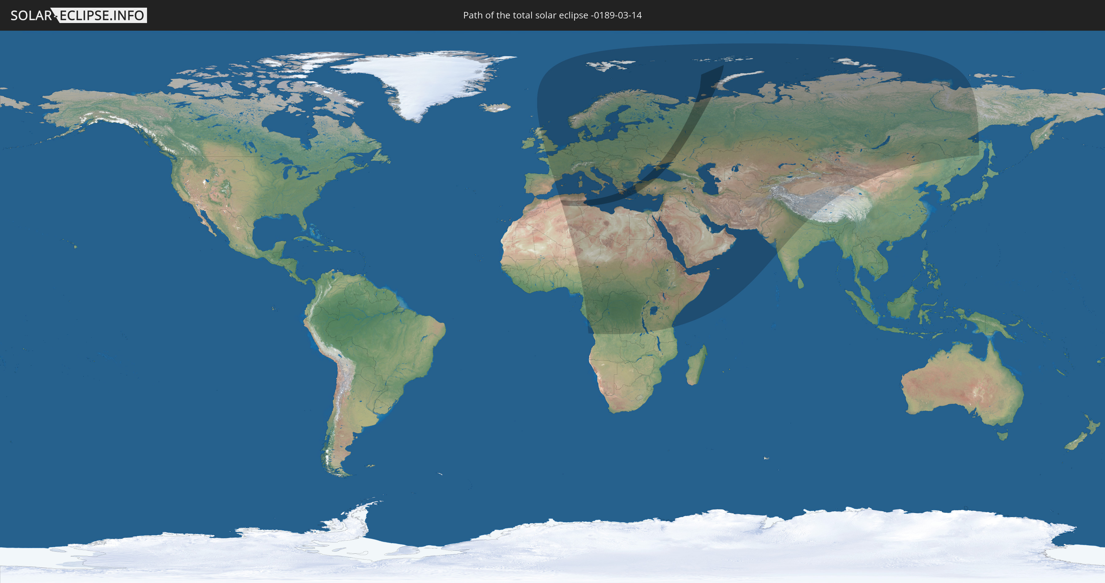
Die Sonnenfinsternis am 03/14/-0189 kann man in 97 Ländern als partielle Sonnenfinsternis beobachten.
Der Finsternispfad verläuft durch 7 Länder. Nur in diesen Ländern ist sie als total Sonnenfinsternis zu sehen.
In den folgenden Ländern ist die Sonnenfinsternis total zu sehen
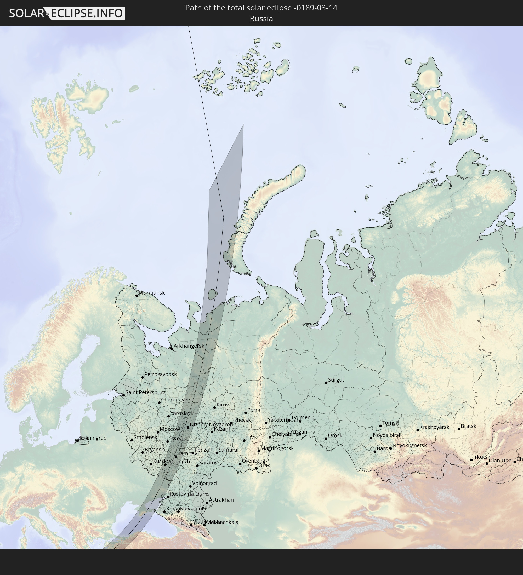 Russia
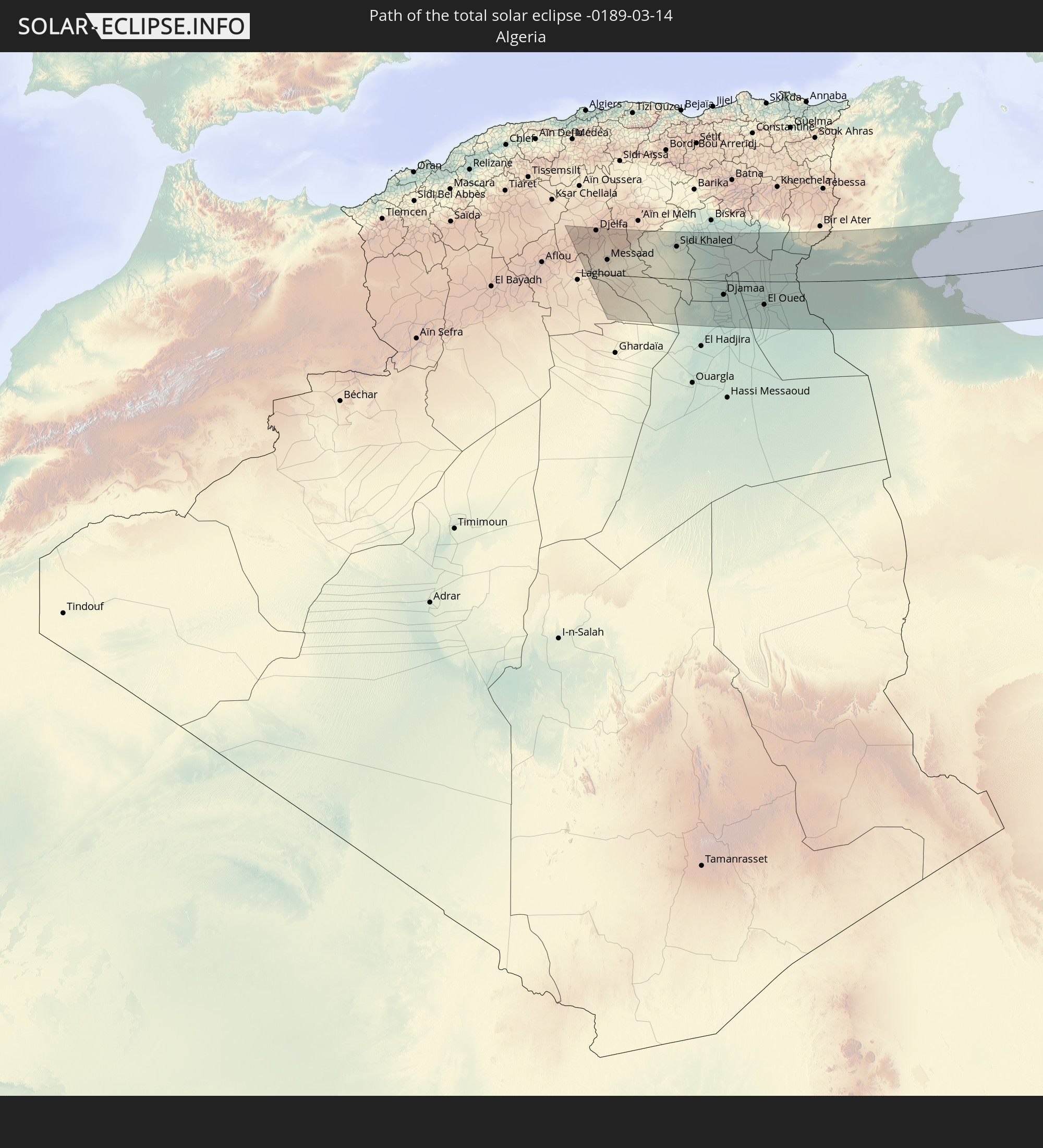 Algeria
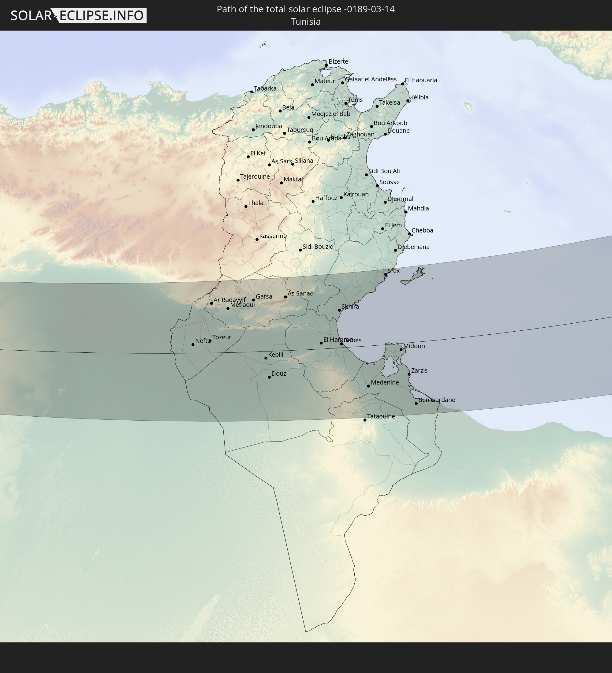 Tunisia
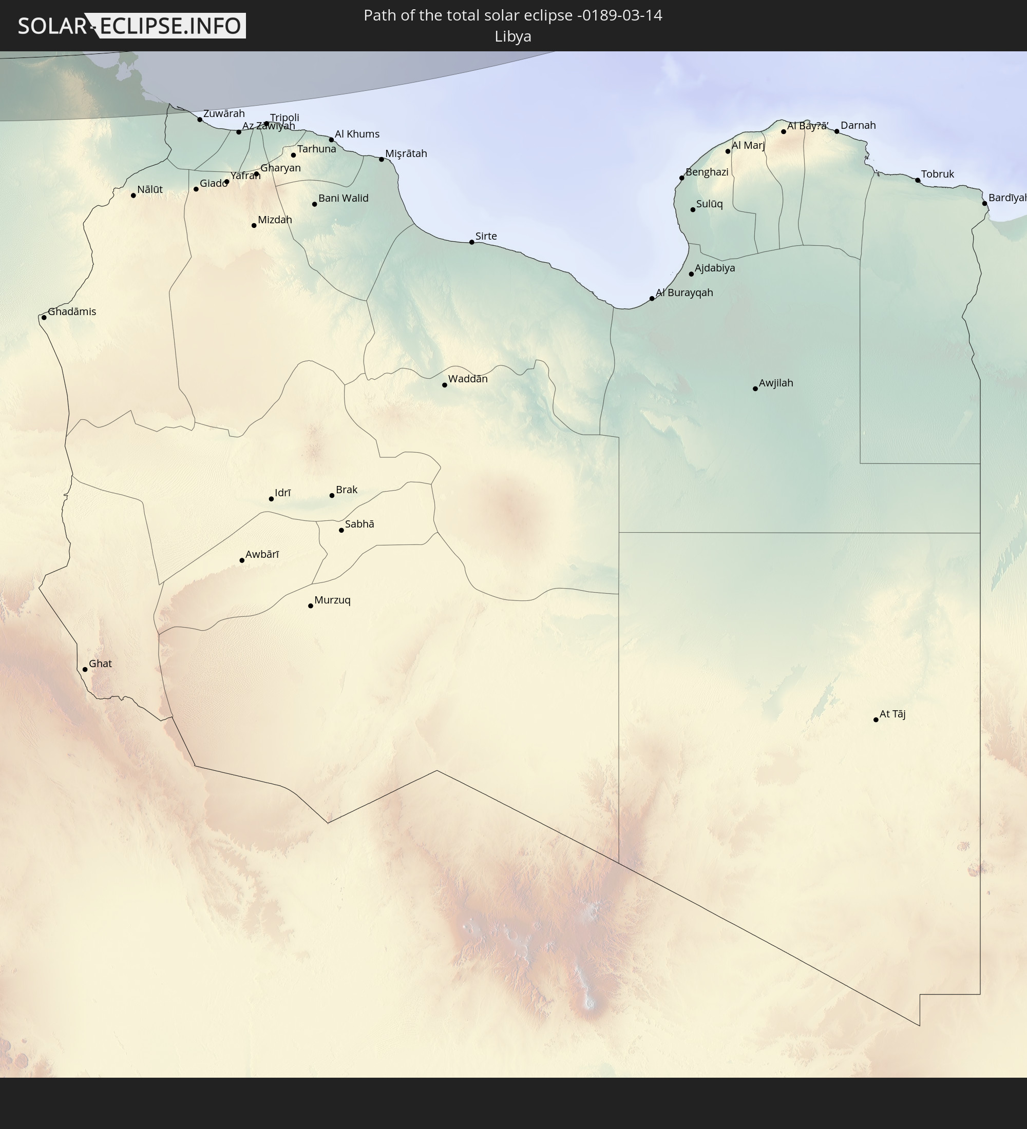 Libya
Libya
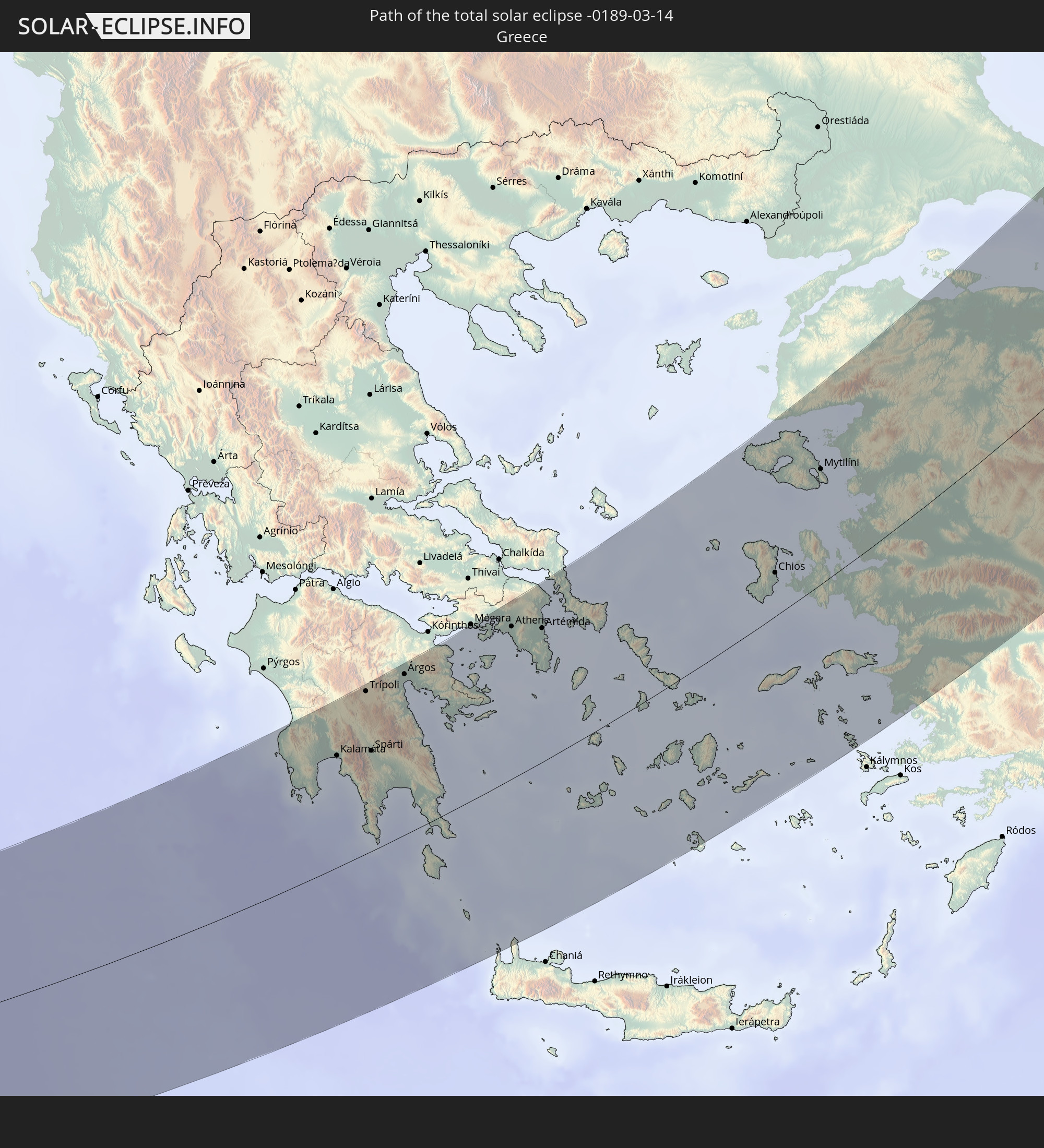 Greece
 Ukraine
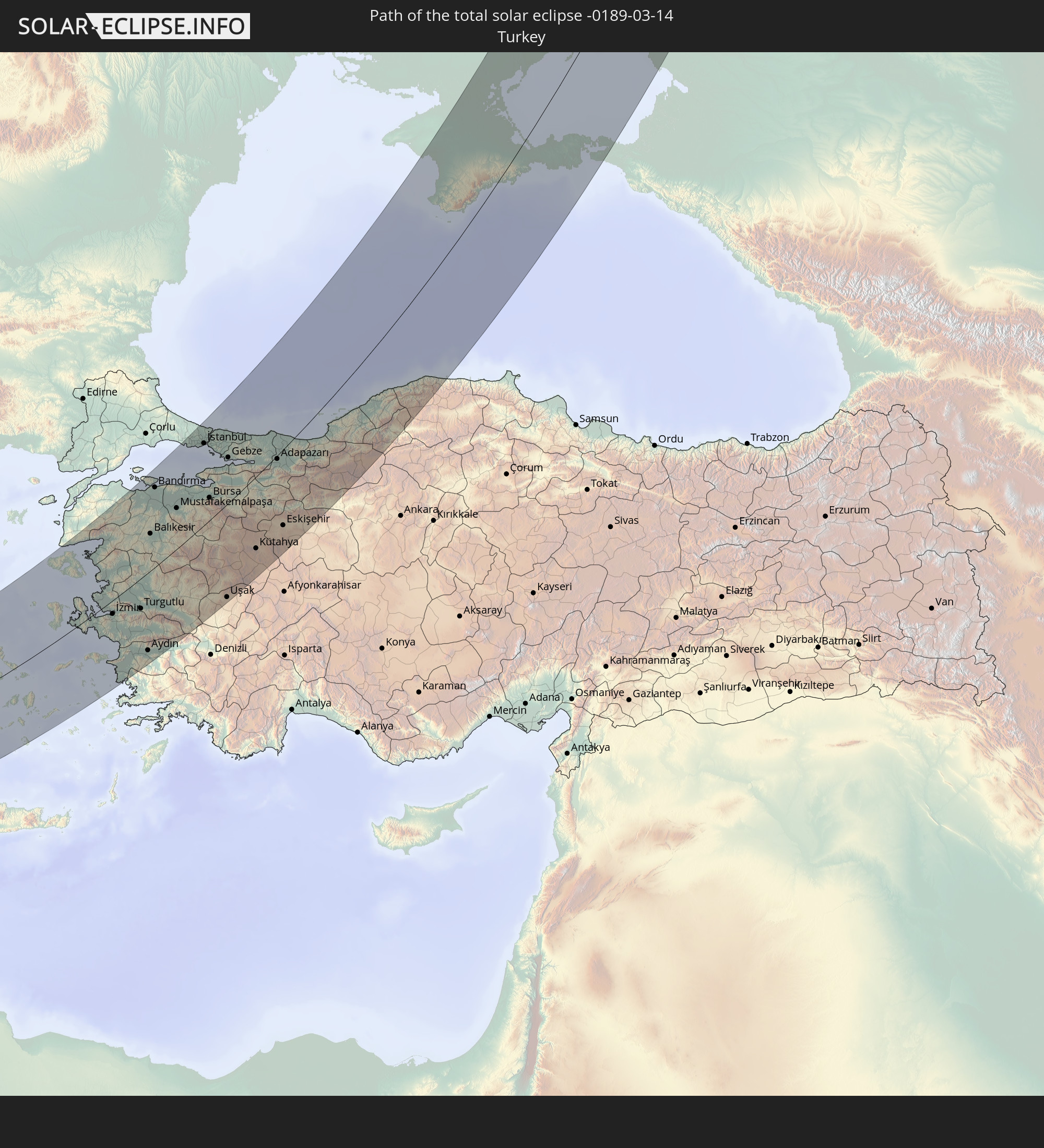 Turkey
In den folgenden Ländern ist die Sonnenfinsternis partiell zu sehen
 Russia
 Spain
Spain
 Svalbard and Jan Mayen
 Algeria
 United Kingdom
 France
 Niger
Niger
 Andorra
 Belgium
 Nigeria
 Netherlands
 Norway
 Equatorial Guinea
 Luxembourg
 Germany
 Switzerland
 Italy
Italy
 Monaco
 Tunisia
 Denmark
 Cameroon
 Gabon
Gabon
 Libya
Libya
 Liechtenstein
 Austria
 Sweden
 Republic of the Congo
 Angola
 Czechia
 Democratic Republic of the Congo
 San Marino
 Vatican City
 Slovenia
 Chad
Chad
 Croatia
 Poland
 Malta
Malta
 Central African Republic
 Bosnia and Herzegovina
 Hungary
 Slovakia
 Montenegro
 Serbia
 Albania
 Åland Islands
 Greece
 Romania
 Republic of Macedonia
 Finland
 Lithuania
 Latvia
 Estonia
 Sudan
Sudan
 Ukraine
 Bulgaria
 Belarus
 Egypt
Egypt
 Turkey
 Moldova
 Rwanda
 Burundi
 Tanzania
 Uganda
 Cyprus
 Ethiopia
 Kenya
Kenya
 State of Palestine
 Israel
 Saudi Arabia
 Jordan
 Lebanon
 Syria
Syria
 Eritrea
 Iraq
Iraq
 Georgia
 Somalia
 Djibouti
 Yemen
Yemen
 Armenia
 Iran
Iran
 Azerbaijan
 Kazakhstan
 Kuwait
 Bahrain
 Qatar
Qatar
 United Arab Emirates
 Oman
Oman
 Turkmenistan
 Uzbekistan
 Afghanistan
 Pakistan
 Tajikistan
 India
India
 Kyrgyzstan
 China
China
 Nepal
Nepal
 Mongolia
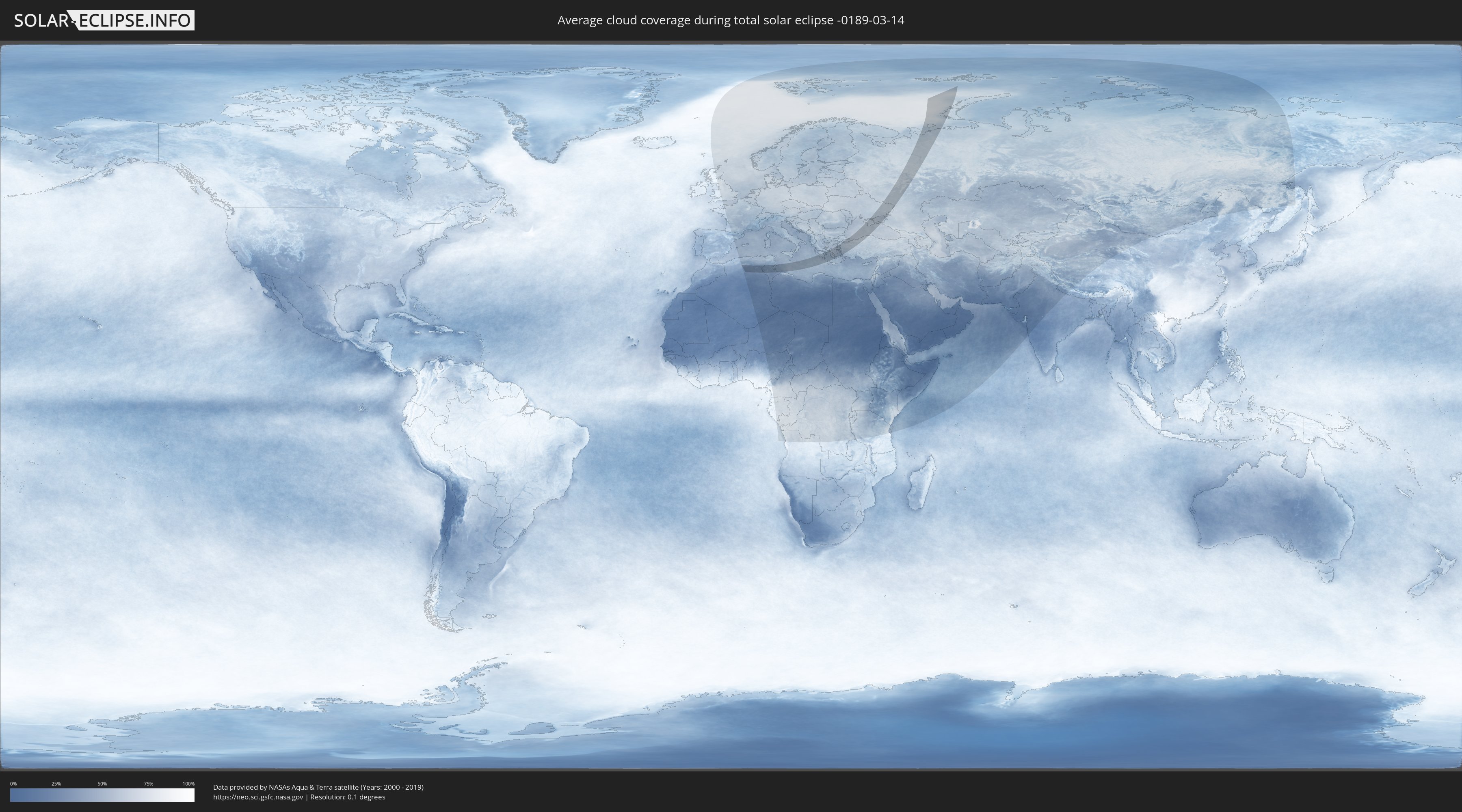
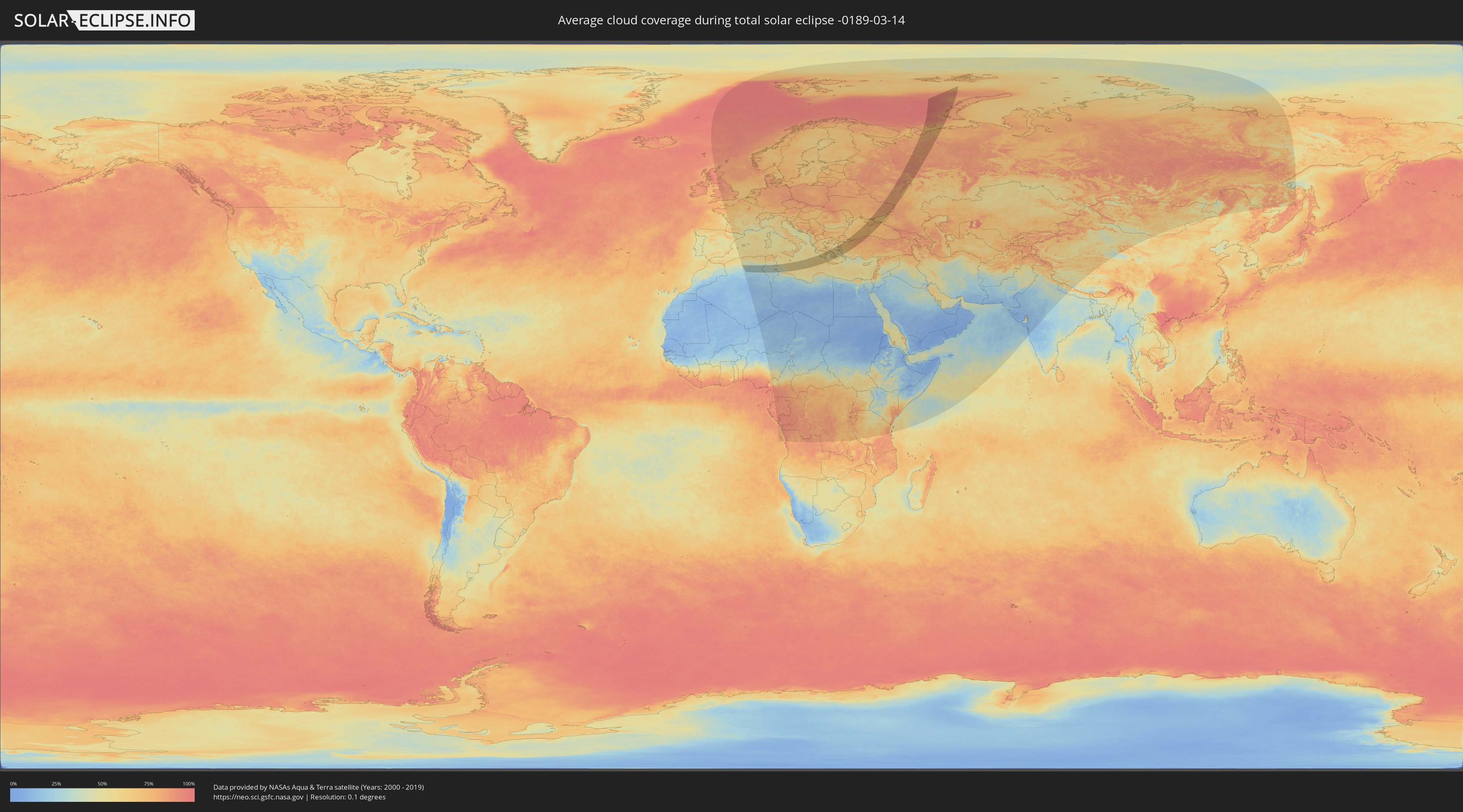
How will be the weather during the total solar eclipse on 03/14/-0189?
Where is the best place to see the total solar eclipse of 03/14/-0189?
The following maps show the average cloud coverage for the day of the total solar eclipse.
With the help of these maps, it is possible to find the place along the eclipse path, which has the best
chance of a cloudless sky.
Nevertheless, you should consider local circumstances and inform about the weather of your chosen
observation site.
The data is provided by NASAs satellites
AQUA and TERRA.
The cloud maps are averaged over a period of 19 years (2000 - 2019).
Detailed country maps
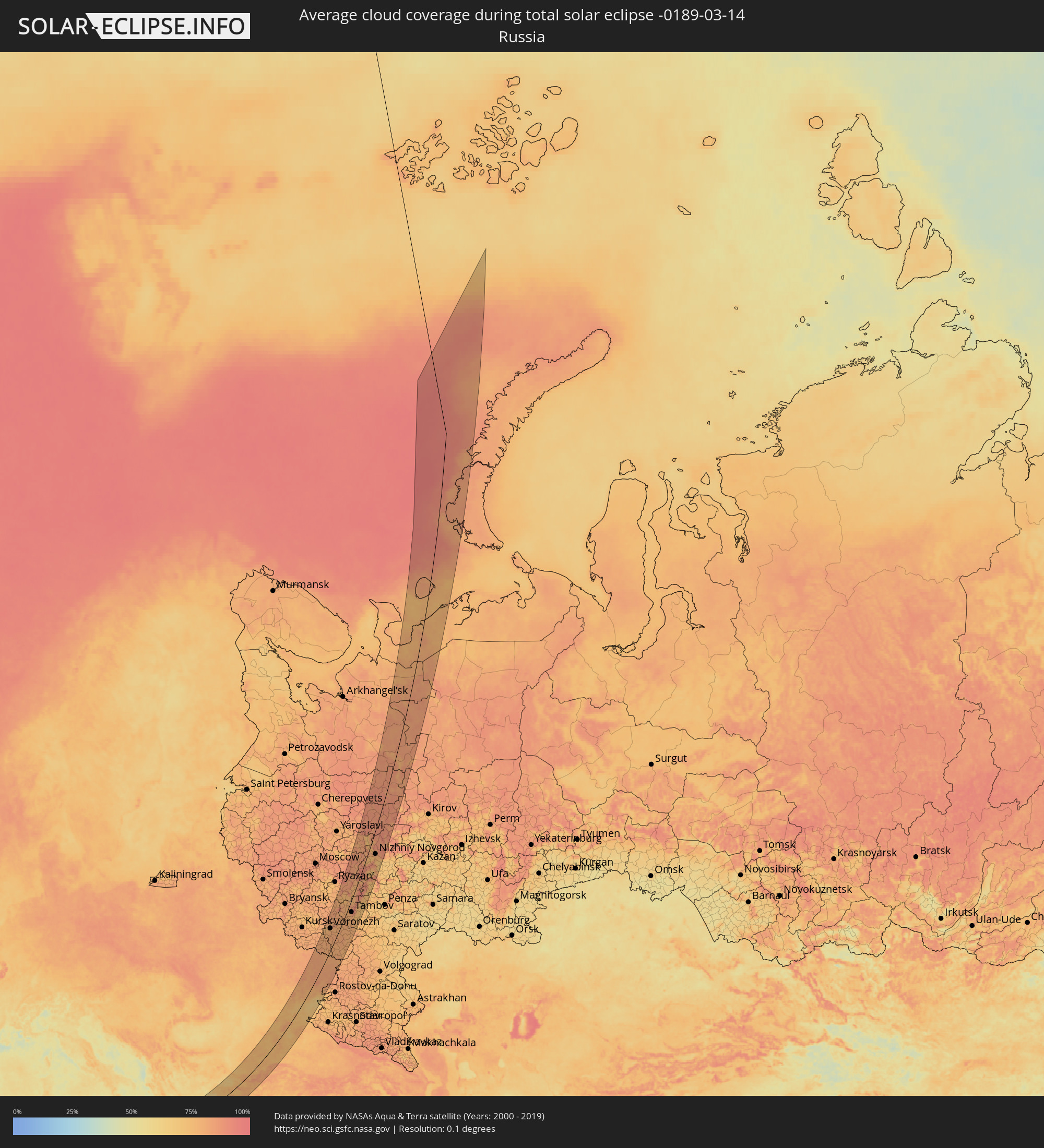 Russia
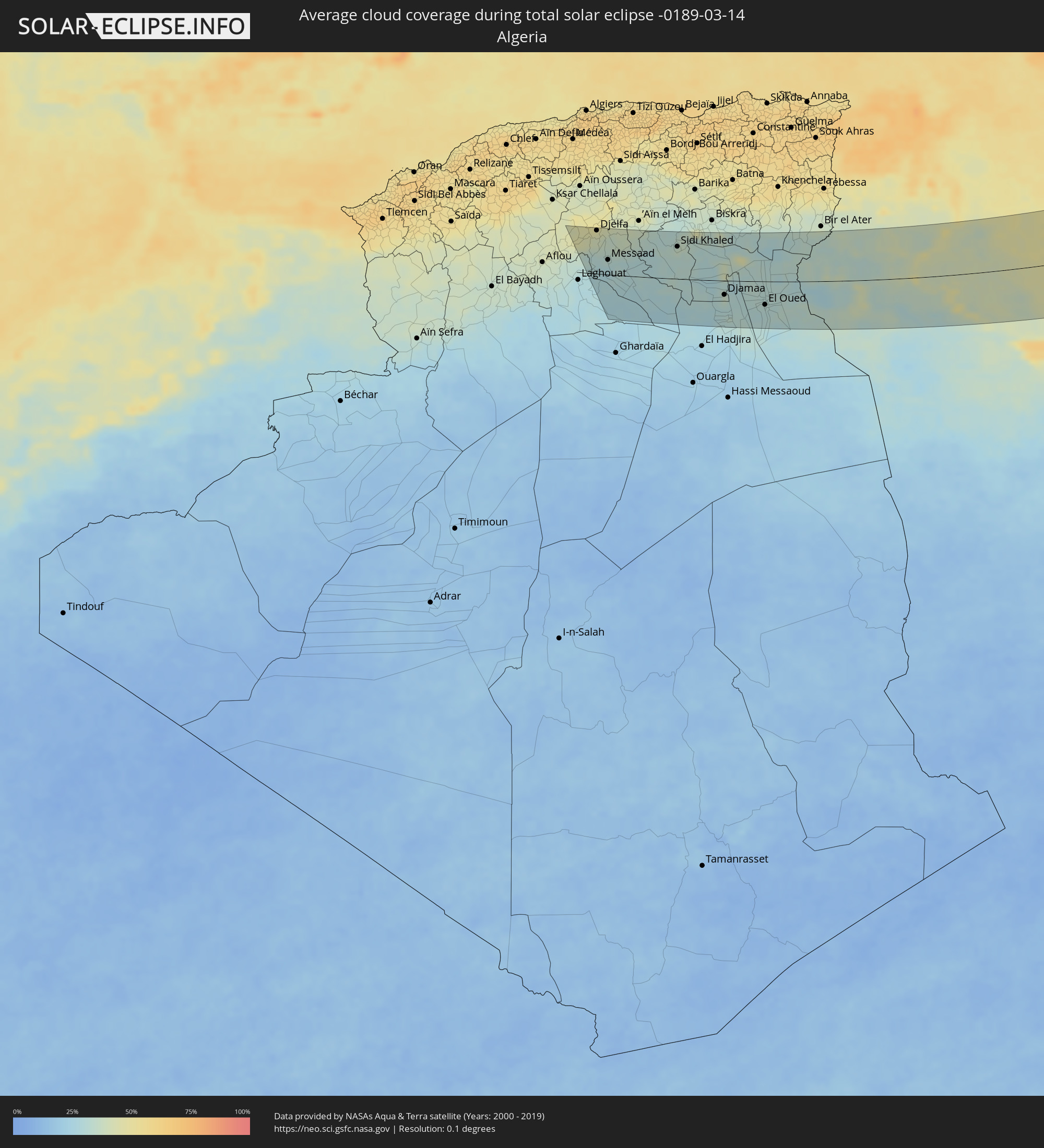 Algeria
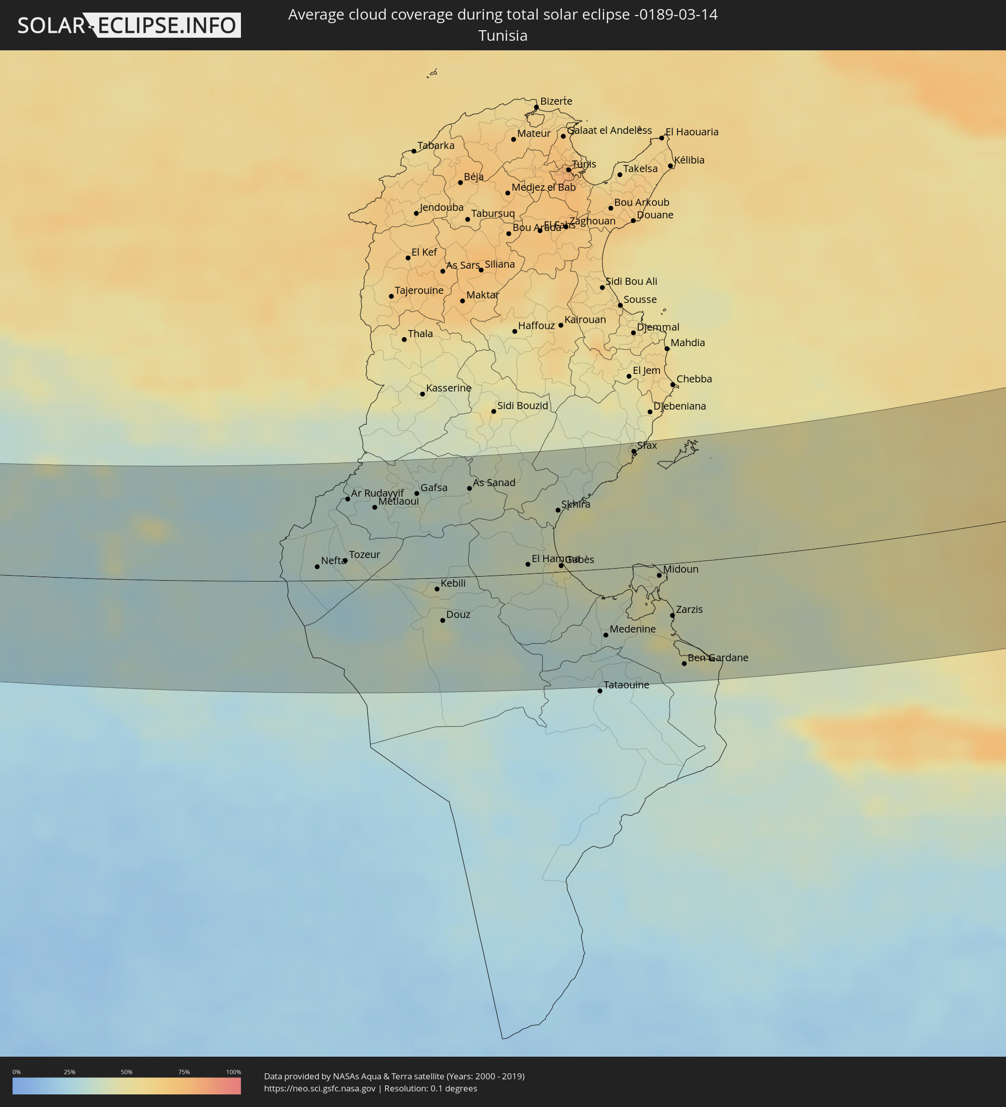 Tunisia
 Libya
Libya
 Greece
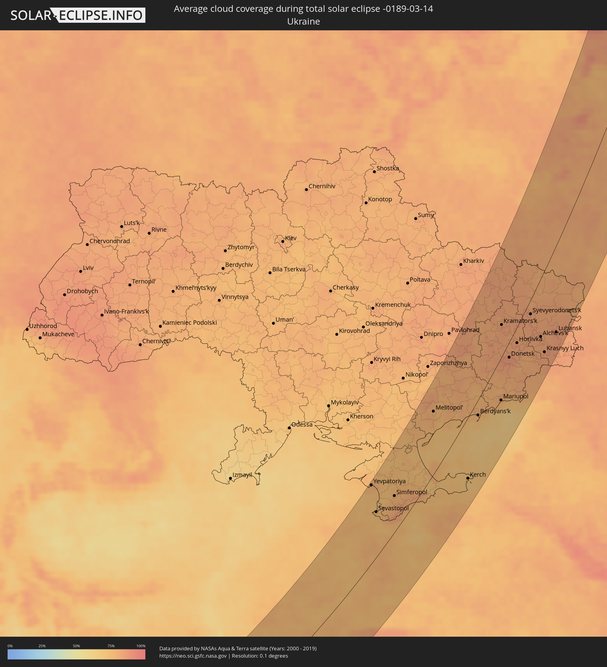 Ukraine
 Turkey
Cities inside the path of the eclipse
The following table shows all locations with a population of more than 5,000 inside the eclipse path. Cities which have more than 100,000 inhabitants are marked bold. A click at the locations opens a detailed map.
| City | Type | Eclipse duration | Local time of max. eclipse | Distance to central line | Ø Cloud coverage |
|
Charef, Djelfa
|
total | - | 06:22:02 UTC+00:09 | 76 km | 46% |
|
’Aïn el Bell, Djelfa
|
total | - | 06:21:38 UTC+00:09 | 48 km | 30% |
|
Djelfa, Djelfa
|
total | - | 06:22:12 UTC+00:09 | 85 km | 44% |
|
Messaad, Djelfa
|
total | - | 06:21:21 UTC+00:09 | 29 km | 32% |
|
Sidi Khaled, Biskra
|
total | - | 06:21:59 UTC+00:09 | 63 km | 36% |
|
Djamaa, Ouargla
|
total | - | 06:20:44 UTC+00:09 | 28 km | 33% |
|
Sidi Amrane, Ouargla
|
total | - | 06:20:41 UTC+00:09 | 32 km | 33% |
|
Touggourt, Ouargla
|
total | - | 06:20:01 UTC+00:09 | 75 km | 31% |
|
Tebesbest, Ouargla
|
total | - | 06:20:03 UTC+00:09 | 74 km | 31% |
|
Megarine, Ouargla
|
total | - | 06:20:10 UTC+00:09 | 66 km | 34% |
|
Reguiba, El Oued
|
total | - | 06:20:56 UTC+00:09 | 23 km | 32% |
|
El Oued, El Oued
|
total | - | 06:20:37 UTC+00:09 | 46 km | 31% |
|
Robbah, El Oued
|
total | - | 06:20:30 UTC+00:09 | 55 km | 30% |
|
Debila, El Oued
|
total | - | 06:20:55 UTC+00:09 | 28 km | 31% |
|
Nefta, Tawzar
|
total | - | 06:21:45 UTC+00:09 | 11 km | 34% |
|
Tozeur, Tawzar
|
total | - | 06:21:53 UTC+00:09 | 16 km | 33% |
|
Ar Rudayyif, Gafsa
|
total | - | 06:22:42 UTC+00:09 | 68 km | 32% |
|
Degache, Tawzar
|
total | - | 06:22:01 UTC+00:09 | 22 km | 40% |
|
Metlaoui, Gafsa
|
total | - | 06:22:40 UTC+00:09 | 60 km | 32% |
|
Gafsa, Gafsa
|
total | - | 06:22:57 UTC+00:09 | 71 km | 38% |
|
Kebili, Qibilī
|
total | - | 06:21:45 UTC+00:09 | 10 km | 40% |
|
El Golaa, Qibilī
|
total | - | 06:21:23 UTC+00:09 | 34 km | 44% |
|
Jemna, Qibilī
|
total | - | 06:21:33 UTC+00:09 | 24 km | 40% |
|
Douz, Qibilī
|
total | - | 06:21:21 UTC+00:09 | 37 km | 44% |
|
As Sanad, Gafsa
|
total | - | 06:23:09 UTC+00:09 | 73 km | 40% |
|
El Hamma, Qābis
|
total | - | 06:22:19 UTC+00:09 | 7 km | 41% |
|
Mezzouna, Sīdī Bū Zayd
|
total | - | 06:23:32 UTC+00:09 | 83 km | 39% |
|
Skhira, Şafāqis
|
total | - | 06:23:07 UTC+00:09 | 51 km | 45% |
|
Gabès, Qābis
|
total | - | 06:22:24 UTC+00:09 | 5 km | 47% |
|
Medenine, Madanīn
|
total | - | 06:21:37 UTC+00:09 | 56 km | 34% |
|
Sfax, Şafāqis
|
total | - | 06:24:08 UTC+00:09 | 96 km | 46% |
|
Gremda, Şafāqis
|
total | - | 06:24:09 UTC+00:09 | 97 km | 49% |
|
Houmt Souk, Madanīn
|
total | - | 06:22:38 UTC+00:09 | 1 km | 44% |
|
Midoun, Madanīn
|
total | - | 06:22:34 UTC+00:09 | 9 km | 43% |
|
Zarzis, Madanīn
|
total | - | 06:22:04 UTC+00:09 | 44 km | 47% |
|
Ben Gardane, Madanīn
|
total | - | 06:21:28 UTC+00:09 | 86 km | 35% |
|
Filiatrá, Peloponnese
|
total | - | 07:59:37 UTC+01:34 | 115 km | 57% |
|
Gargaliánoi, Peloponnese
|
total | - | 07:59:29 UTC+01:34 | 104 km | 57% |
|
Messíni, Peloponnese
|
total | - | 07:59:42 UTC+01:34 | 88 km | 58% |
|
Kalamáta, Peloponnese
|
total | - | 07:59:45 UTC+01:34 | 83 km | 54% |
|
Trípoli, Peloponnese
|
total | - | 08:00:50 UTC+01:34 | 119 km | 64% |
|
Spárti, Peloponnese
|
total | - | 08:00:03 UTC+01:34 | 74 km | 63% |
|
Árgos, Peloponnese
|
total | - | 08:01:19 UTC+01:34 | 116 km | 57% |
|
Néa Péramos, Attica
|
total | - | 08:02:31 UTC+01:34 | 123 km | 61% |
|
Aegina, Attica
|
total | - | 08:02:02 UTC+01:34 | 98 km | 55% |
|
Salamína, Attica
|
total | - | 08:02:30 UTC+01:34 | 116 km | 60% |
|
Athens, Attica
|
total | - | 08:02:41 UTC+01:34 | 108 km | 68% |
|
Zefyri, Attica
|
total | - | 08:02:51 UTC+01:34 | 116 km | 75% |
|
Néa Chalkidóna, Attica
|
total | - | 08:02:47 UTC+01:34 | 112 km | 68% |
|
Psychikó, Attica
|
total | - | 08:02:48 UTC+01:34 | 108 km | 69% |
|
Voúla, Attica
|
total | - | 08:02:28 UTC+01:34 | 92 km | 58% |
|
Lykóvrysi, Attica
|
total | - | 08:02:54 UTC+01:34 | 113 km | 72% |
|
Filothéi, Attica
|
total | - | 08:02:49 UTC+01:34 | 109 km | 69% |
|
Néa Erythraía, Attica
|
total | - | 08:02:59 UTC+01:34 | 114 km | 72% |
|
Ágios Stéfanos, Attica
|
total | - | 08:03:07 UTC+01:34 | 117 km | 67% |
|
Anoixi, Attica
|
total | - | 08:03:05 UTC+01:34 | 116 km | 67% |
|
Néa Pentéli, Attica
|
total | - | 08:02:57 UTC+01:34 | 109 km | 67% |
|
Drosiá, Attica
|
total | - | 08:03:04 UTC+01:34 | 114 km | 67% |
|
Spáta, Attica
|
total | - | 08:02:48 UTC+01:34 | 97 km | 67% |
|
Markópoulo, Attica
|
total | - | 08:02:40 UTC+01:34 | 89 km | 65% |
|
Marathónas, Attica
|
total | - | 08:03:12 UTC+01:34 | 113 km | 62% |
|
Keratéa, Attica
|
total | - | 08:02:33 UTC+01:34 | 79 km | 61% |
|
Artémida, Attica
|
total | - | 08:02:52 UTC+01:34 | 94 km | 63% |
|
Limín Mesoyaías, Attica
|
total | - | 08:02:44 UTC+01:34 | 86 km | 61% |
|
Lávrio, Attica
|
total | - | 08:02:26 UTC+01:34 | 67 km | 60% |
|
Ermoúpolis, South Aegean
|
total | - | 08:02:35 UTC+01:34 | 1 km | 59% |
|
Náxos, South Aegean
|
total | - | 08:02:17 UTC+01:34 | 52 km | 62% |
|
Chios, North Aegean
|
total | - | 08:05:18 UTC+01:34 | 29 km | 65% |
|
Mytilíni, North Aegean
|
total | - | 08:07:03 UTC+01:34 | 74 km | 57% |
|
Néon Karlovásion, North Aegean
|
total | - | 08:04:39 UTC+01:34 | 52 km | 56% |
|
Menemen, İzmir
|
total | - | 08:28:35 UTC+01:56 | 2 km | 69% |
|
İzmir, İzmir
|
total | - | 08:28:16 UTC+01:56 | 19 km | 66% |
|
Bergama, İzmir
|
total | - | 08:29:39 UTC+01:56 | 42 km | 67% |
|
Kuşadası, Aydın
|
total | - | 08:27:18 UTC+01:56 | 75 km | 57% |
|
Söke, Aydın
|
total | - | 08:27:13 UTC+01:56 | 92 km | 57% |
|
Manisa, Manisa
|
total | - | 08:28:53 UTC+01:56 | 16 km | 72% |
|
Soma, Manisa
|
total | - | 08:30:08 UTC+01:56 | 24 km | 72% |
|
Turgutlu, Manisa
|
total | - | 08:28:53 UTC+01:56 | 41 km | 67% |
|
Aydın, Aydın
|
total | - | 08:27:46 UTC+01:56 | 106 km | 58% |
|
Akhisar, Manisa
|
total | - | 08:29:49 UTC+01:56 | 11 km | 64% |
|
Balıkesir, Balıkesir
|
total | - | 08:31:16 UTC+01:56 | 49 km | 73% |
|
Ödemiş, İzmir
|
total | - | 08:28:36 UTC+01:56 | 79 km | 63% |
|
Bandırma, Balıkesir
|
total | - | 08:32:41 UTC+01:56 | 103 km | 66% |
|
Salihli, Manisa
|
total | - | 08:29:15 UTC+01:56 | 66 km | 66% |
|
Mustafakemalpaşa, Bursa
|
total | - | 08:32:27 UTC+01:56 | 52 km | 75% |
|
Esenyurt, Istanbul
|
total | - | 08:34:35 UTC+01:56 | 118 km | 73% |
|
İstanbul, Istanbul
|
total | - | 08:34:48 UTC+01:56 | 101 km | 74% |
|
Bursa, Bursa
|
total | - | 08:33:20 UTC+01:56 | 28 km | 79% |
|
Maltepe, Istanbul
|
total | - | 08:34:50 UTC+01:56 | 82 km | 74% |
|
Gemlik, Bursa
|
total | - | 08:33:52 UTC+01:56 | 42 km | 74% |
|
Yalova, Yalova
|
total | - | 08:34:24 UTC+01:56 | 53 km | 71% |
|
Uşak, Uşak
|
total | - | 08:30:43 UTC+01:56 | 119 km | 73% |
|
Gebze, Kocaeli
|
total | - | 08:34:49 UTC+01:56 | 55 km | 74% |
|
İnegol, Bursa
|
total | - | 08:33:30 UTC+01:56 | 8 km | 74% |
|
İzmit, Kocaeli
|
total | - | 08:35:11 UTC+01:56 | 24 km | 78% |
|
Kütahya, Kütahya
|
total | - | 08:32:40 UTC+01:56 | 89 km | 78% |
|
Bozüyük, Bilecik
|
total | - | 08:33:39 UTC+01:56 | 52 km | 79% |
|
Adapazarı, Sakarya
|
total | - | 08:35:39 UTC+01:56 | 4 km | 78% |
|
Eskişehir, Eskişehir
|
total | - | 08:33:50 UTC+01:56 | 91 km | 78% |
|
Düzce, Düzce
|
total | - | 08:36:28 UTC+01:56 | 46 km | 81% |
|
Ereğli, Zonguldak
|
total | - | 08:37:33 UTC+01:56 | 27 km | 73% |
|
Bolu, Bolu
|
total | - | 08:36:40 UTC+01:56 | 80 km | 82% |
|
Zonguldak, Zonguldak
|
total | - | 08:38:13 UTC+01:56 | 38 km | 76% |
|
Karabük, Karabük
|
total | - | 08:38:32 UTC+01:56 | 108 km | 77% |
|
Yevpatoriya, Republic of Crimea
|
total | - | 09:05:50 UTC+02:16 | 117 km | 76% |
|
Sevastopol, Gorod Sevastopol
|
total | - | 09:04:51 UTC+02:16 | 68 km | 73% |
|
Saki, Republic of Crimea
|
total | - | 09:05:56 UTC+02:16 | 97 km | 73% |
|
Simferopol, Republic of Crimea
|
total | - | 09:06:06 UTC+02:16 | 53 km | 78% |
|
Yalta, Republic of Crimea
|
total | - | 09:05:18 UTC+02:16 | 21 km | 77% |
|
Dzhankoy, Republic of Crimea
|
total | - | 09:07:46 UTC+02:16 | 80 km | 75% |
|
Alushta, Republic of Crimea
|
total | - | 09:05:52 UTC+02:16 | 16 km | 78% |
|
Melitopol’, Zaporizhia
|
total | - | 08:56:51 UTC+02:02 | 81 km | 78% |
|
Feodosiya, Republic of Crimea
|
total | - | 09:07:29 UTC+02:16 | 25 km | 74% |
|
Tokmak, Zaporizhia
|
total | - | 08:57:55 UTC+02:02 | 80 km | 77% |
|
Kerch, Republic of Crimea
|
total | - | 09:09:09 UTC+02:16 | 79 km | 70% |
|
Berdyans’k, Zaporizhia
|
total | - | 08:58:06 UTC+02:02 | 18 km | 74% |
|
Dobropillya, Donetsk
|
total | - | 09:01:24 UTC+02:02 | 53 km | 84% |
|
Krasnoarmiys’k, Donetsk
|
total | - | 09:01:11 UTC+02:02 | 38 km | 83% |
|
Izyum, Kharkiv
|
total | - | 09:02:52 UTC+02:02 | 79 km | 81% |
|
Mariupol, Donetsk
|
total | - | 08:59:26 UTC+02:02 | 49 km | 76% |
|
Kramators’k, Donetsk
|
total | - | 09:02:20 UTC+02:02 | 35 km | 84% |
|
Kupjansk, Kharkiv
|
total | - | 09:04:06 UTC+02:02 | 79 km | 82% |
|
Sloviansk, Donetsk
|
total | - | 09:02:38 UTC+02:02 | 38 km | 82% |
|
Kostyantynivka, Donetsk
|
total | - | 09:02:08 UTC+02:02 | 15 km | 82% |
|
Donetsk, Donetsk
|
total | - | 09:01:21 UTC+02:02 | 17 km | 86% |
|
Dzerzhyns’k, Donetsk
|
total | - | 09:02:03 UTC+02:02 | 1 km | 81% |
|
Artemivs’k, Donetsk
|
total | - | 09:02:33 UTC+02:02 | 1 km | 81% |
|
Horlivka, Donetsk
|
total | - | 09:02:09 UTC+02:02 | 17 km | 83% |
|
Valuyki, Belgorod
|
total | - | 09:33:38 UTC+02:30 | 70 km | 82% |
|
Khartsyz’k, Donetsk
|
total | - | 09:01:43 UTC+02:02 | 38 km | 81% |
|
Yenakiyeve, Donetsk
|
total | - | 09:02:07 UTC+02:02 | 33 km | 81% |
|
Debal’tseve, Donetsk
|
total | - | 09:02:30 UTC+02:02 | 40 km | 82% |
|
Shakhtars’k, Donetsk
|
total | - | 09:02:02 UTC+02:02 | 57 km | 79% |
|
Syevyerodonets’k, Luhansk
|
total | - | 09:03:39 UTC+02:02 | 15 km | 82% |
|
Rossosh’, Voronezj
|
total | - | 09:35:35 UTC+02:30 | 85 km | 79% |
|
Stakhanov, Luhansk
|
total | - | 09:03:08 UTC+02:02 | 44 km | 85% |
|
Alekseyevka, Belgorod
|
total | - | 09:34:56 UTC+02:30 | 52 km | 79% |
|
Snizhne, Donetsk
|
total | - | 09:02:19 UTC+02:02 | 80 km | 82% |
|
Alchevs’k, Luhansk
|
total | - | 09:03:08 UTC+02:02 | 60 km | 84% |
|
Krasnyy Luch, Luhansk
|
total | - | 09:02:41 UTC+02:02 | 85 km | 83% |
|
Ostrogozhsk, Voronezj
|
total | - | 09:35:42 UTC+02:30 | 38 km | 81% |
|
Voronezh, Voronezj
|
total | - | 09:37:09 UTC+02:30 | 66 km | 80% |
|
Novovoronezh, Voronezj
|
total | - | 09:36:35 UTC+02:30 | 48 km | 81% |
|
Luhansk, Luhansk
|
total | - | 09:03:49 UTC+02:02 | 88 km | 85% |
|
Liski, Voronezj
|
total | - | 09:36:20 UTC+02:30 | 15 km | 82% |
|
Rossosh’, Voronezj
|
total | - | 09:35:04 UTC+02:30 | 25 km | 79% |
|
Lipetsk, Lipetsk
|
total | - | 09:39:03 UTC+02:30 | 80 km | 86% |
|
Gryazi, Lipetsk
|
total | - | 09:39:13 UTC+02:30 | 53 km | 81% |
|
Michurinsk, Tambov
|
total | - | 09:40:24 UTC+02:30 | 34 km | 83% |
|
Kasimov, Rjazan
|
total | - | 09:44:26 UTC+02:30 | 57 km | 83% |
|
Tambov, Tambov
|
total | - | 09:41:03 UTC+02:30 | 32 km | 81% |
|
Kotovsk, Tambov
|
total | - | 09:40:53 UTC+02:30 | 42 km | 83% |
|
Morshansk, Tambov
|
total | - | 09:42:31 UTC+02:30 | 26 km | 84% |
|
Rasskazovo, Tambov
|
total | - | 09:41:21 UTC+02:30 | 63 km | 79% |
|
Vichuga, Ivanovo
|
total | - | 09:48:18 UTC+02:30 | 102 km | 80% |
|
Murom, Vladimir
|
total | - | 09:45:59 UTC+02:30 | 41 km | 81% |
|
Kineshma, Ivanovo
|
total | - | 09:48:48 UTC+02:30 | 97 km | 85% |
|
Vyazniki, Vladimir
|
total | - | 09:47:05 UTC+02:30 | 57 km | 82% |
|
Vyksa, Nizjnij Novgorod
|
total | - | 09:45:44 UTC+02:30 | 23 km | 87% |
|
Kulebaki, Nizjnij Novgorod
|
total | - | 09:46:12 UTC+02:30 | 6 km | 91% |
|
Pavlovo, Nizjnij Novgorod
|
total | - | 09:47:32 UTC+02:30 | 8 km | 76% |
|
Sarov, Nizjnij Novgorod
|
total | - | 09:46:14 UTC+02:30 | 60 km | 88% |
|
Zavolzh’ye, Nizjnij Novgorod
|
total | - | 09:48:47 UTC+02:30 | 2 km | 80% |
|
Dzerzhinsk, Nizjnij Novgorod
|
total | - | 09:48:16 UTC+02:30 | 19 km | 75% |
|
Bogorodsk, Nizjnij Novgorod
|
total | - | 09:48:07 UTC+02:30 | 28 km | 73% |
|
Novaya Balakhna, Nizjnij Novgorod
|
total | - | 09:48:45 UTC+02:30 | 19 km | 80% |
|
Arzamas, Nizjnij Novgorod
|
total | - | 09:47:24 UTC+02:30 | 73 km | 75% |
|
Nizhniy Novgorod, Nizjnij Novgorod
|
total | - | 09:48:54 UTC+02:30 | 48 km | 80% |
|
Kstovo, Nizjnij Novgorod
|
total | - | 09:48:49 UTC+02:30 | 66 km | 77% |
|
Velikiy Ustyug, Vologda
|
total | - | 09:56:49 UTC+02:30 | 33 km | 77% |
|
Kotlas, Arkhangelskaya
|
total | - | 09:57:42 UTC+02:30 | 36 km | 76% |
|
Koryazhma, Arkhangelskaya
|
total | - | 09:58:11 UTC+02:30 | 61 km | 85% |