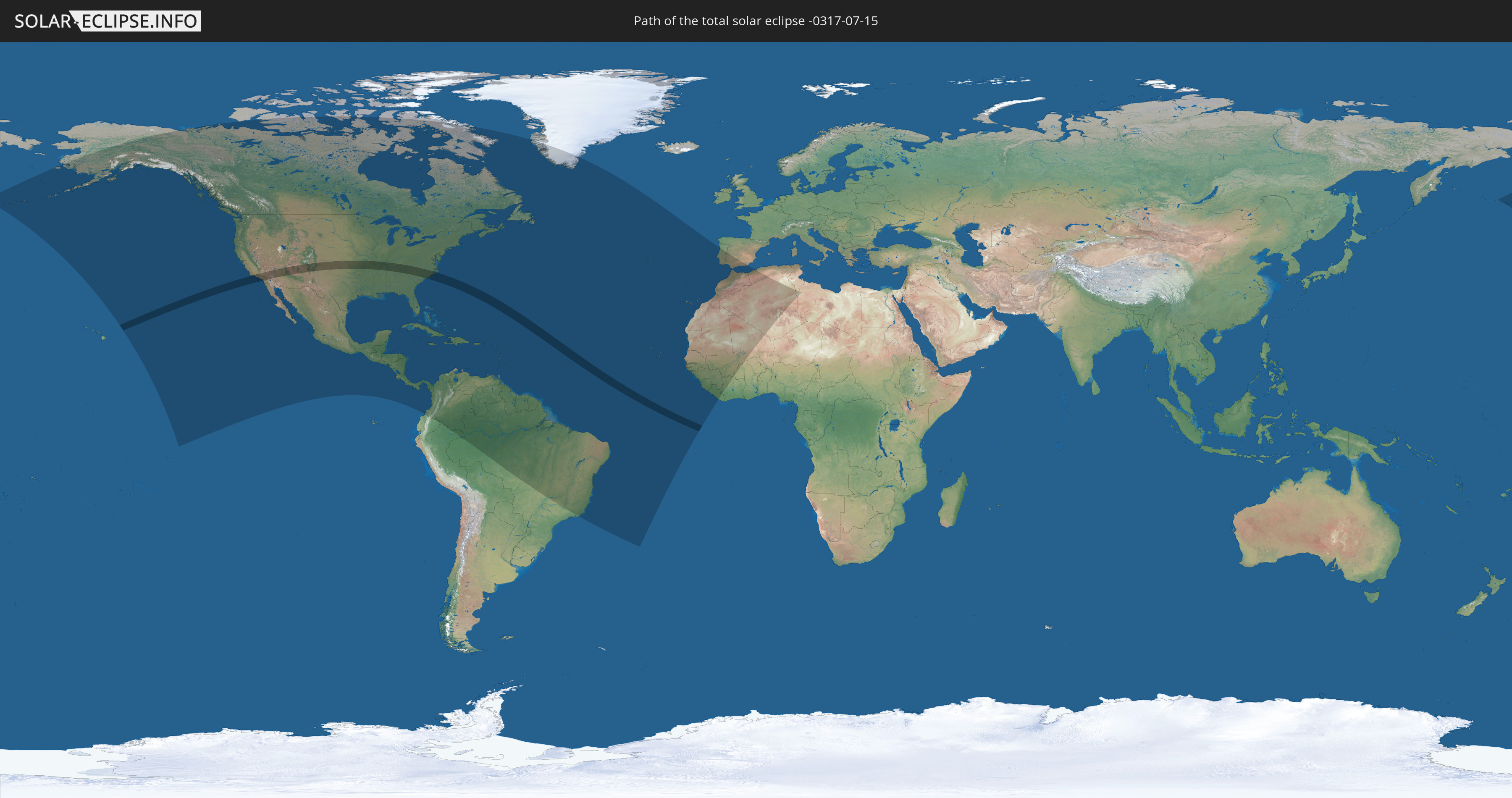
Total solar eclipse of 07/15/-0317
| Day of week: | Tuesday |
| Maximum duration of eclipse: | 05m21s |
| Maximum width of eclipse path: | 214 km |
| Saros cycle: | 60 |
| Coverage: | 100% |
| Magnitude: | 1.0642 |
| Gamma: | 0.189 |
Wo kann man die Sonnenfinsternis vom 07/15/-0317 sehen?
Die Sonnenfinsternis am 07/15/-0317 kann man in 65 Ländern als partielle Sonnenfinsternis beobachten.
Der Finsternispfad verläuft durch ein Land. Nur in diesem Land ist sie als total Sonnenfinsternis zu sehen.
In den folgenden Ländern ist die Sonnenfinsternis total zu sehen
 United States
In den folgenden Ländern ist die Sonnenfinsternis partiell zu sehen
 United States
 United States Minor Outlying Islands
 Canada
 Mexico
 Greenland
 Guatemala
 Ecuador
 El Salvador
 Honduras
 Belize
 Nicaragua
 Costa Rica
 Cuba
Cuba
 Panama
 Colombia
 Cayman Islands
 Peru
Peru
 The Bahamas
 Jamaica
 Haiti
Haiti
 Brazil
 Venezuela
 Turks and Caicos Islands
 Dominican Republic
 Aruba
Aruba
 Puerto Rico
 United States Virgin Islands
 Bermuda
 British Virgin Islands
 Anguilla
 Collectivity of Saint Martin
 Saint Barthélemy
 Saint Kitts and Nevis
 Antigua and Barbuda
 Montserrat
 Trinidad and Tobago
 Guadeloupe
 Grenada
 Dominica
 Saint Vincent and the Grenadines
 Guyana
 Martinique
 Saint Lucia
 Barbados
 Suriname
 Saint Pierre and Miquelon
 French Guiana
 Portugal
 Cabo Verde
 Spain
Spain
 Senegal
 Mauritania
 The Gambia
 Guinea-Bissau
 Guinea
 Sierra Leone
 Morocco
 Mali
Mali
 Liberia
 Algeria
 Ivory Coast
 Burkina Faso
 Gibraltar
 Tunisia
 Libya
Libya
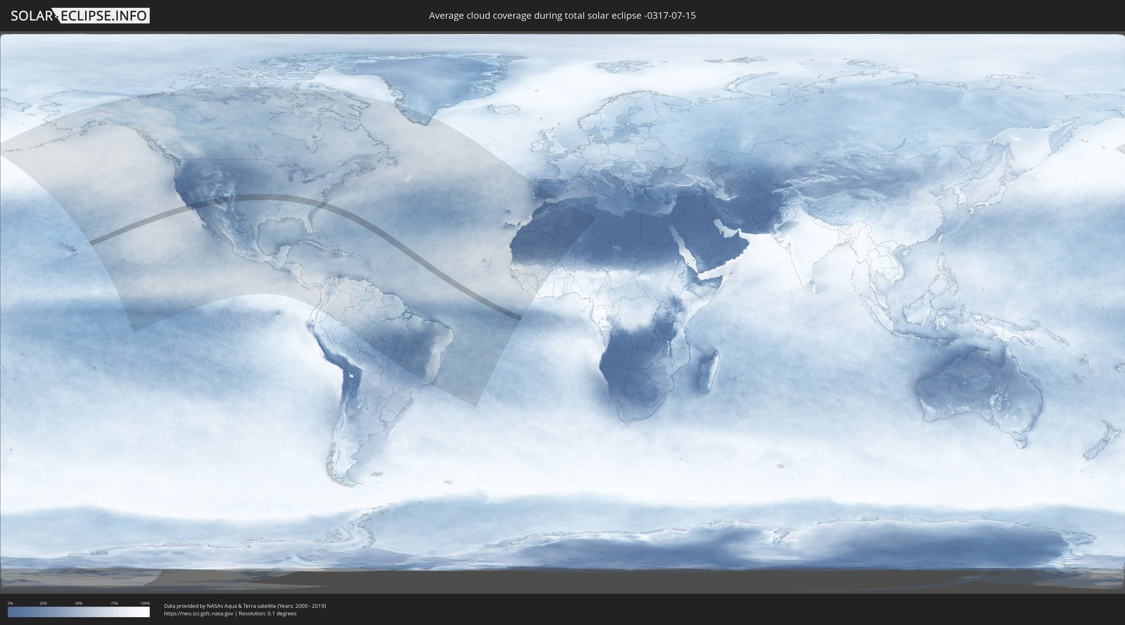
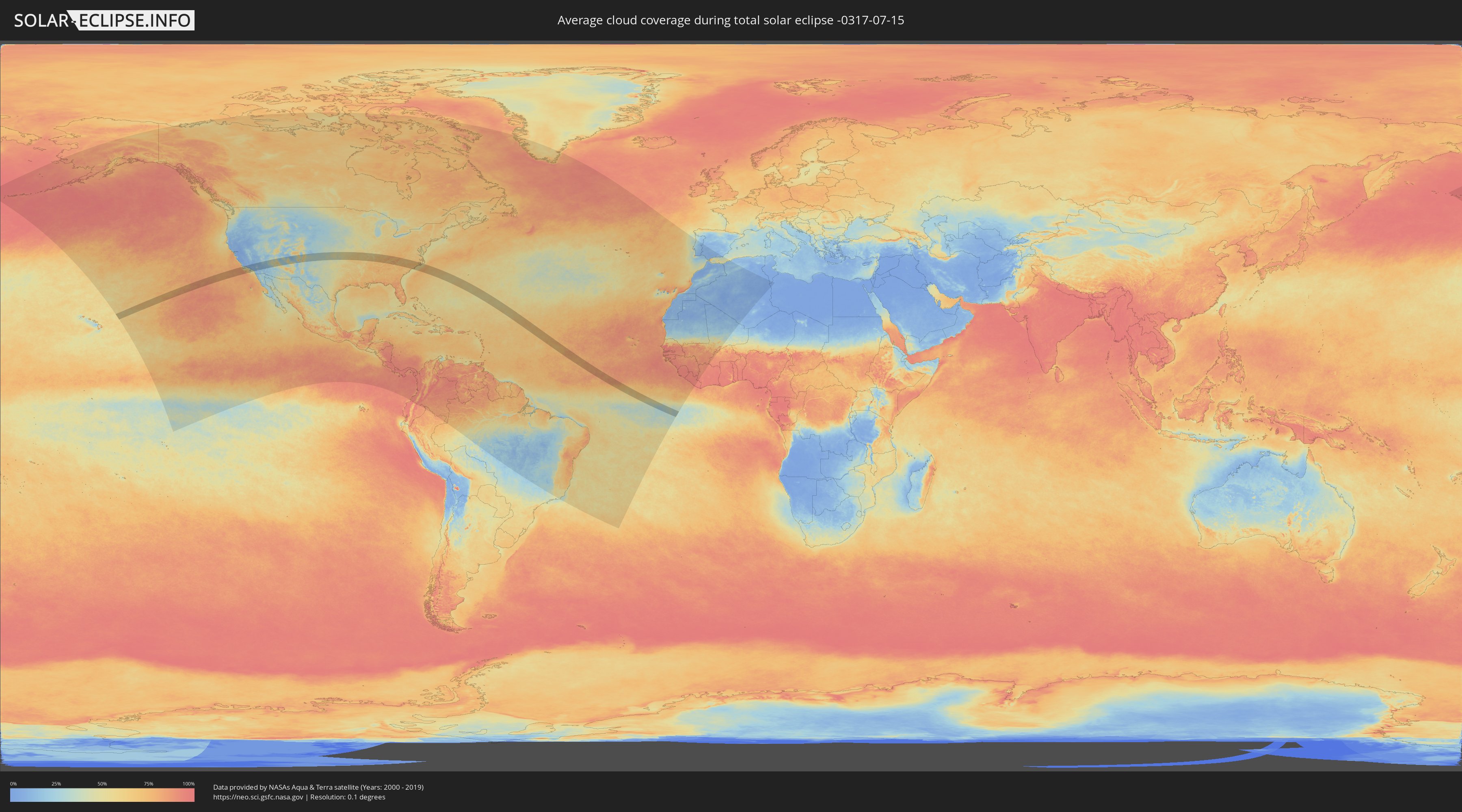
How will be the weather during the total solar eclipse on 07/15/-0317?
Where is the best place to see the total solar eclipse of 07/15/-0317?
The following maps show the average cloud coverage for the day of the total solar eclipse.
With the help of these maps, it is possible to find the place along the eclipse path, which has the best
chance of a cloudless sky.
Nevertheless, you should consider local circumstances and inform about the weather of your chosen
observation site.
The data is provided by NASAs satellites
AQUA and TERRA.
The cloud maps are averaged over a period of 19 years (2000 - 2019).
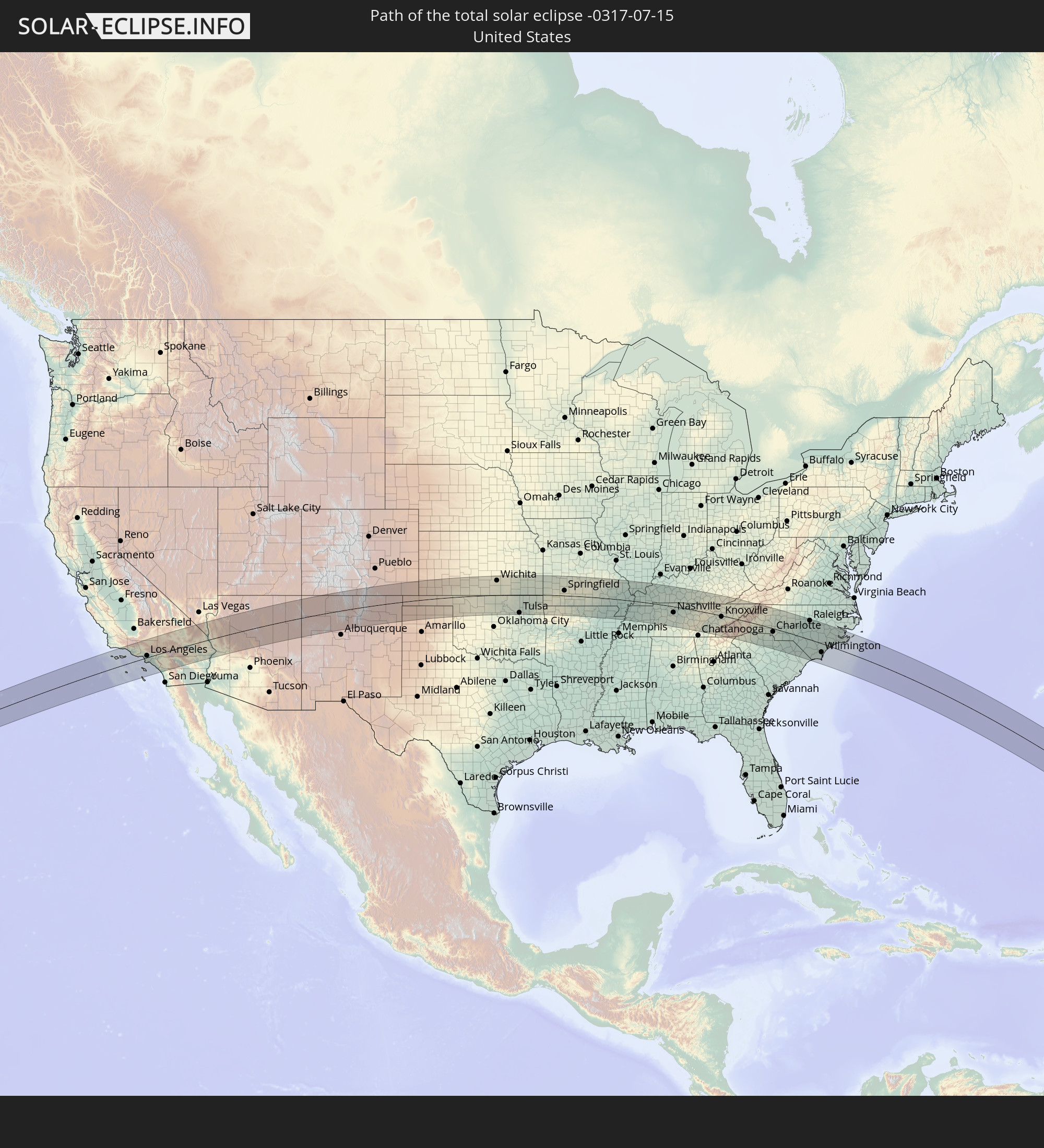
Detailed country maps
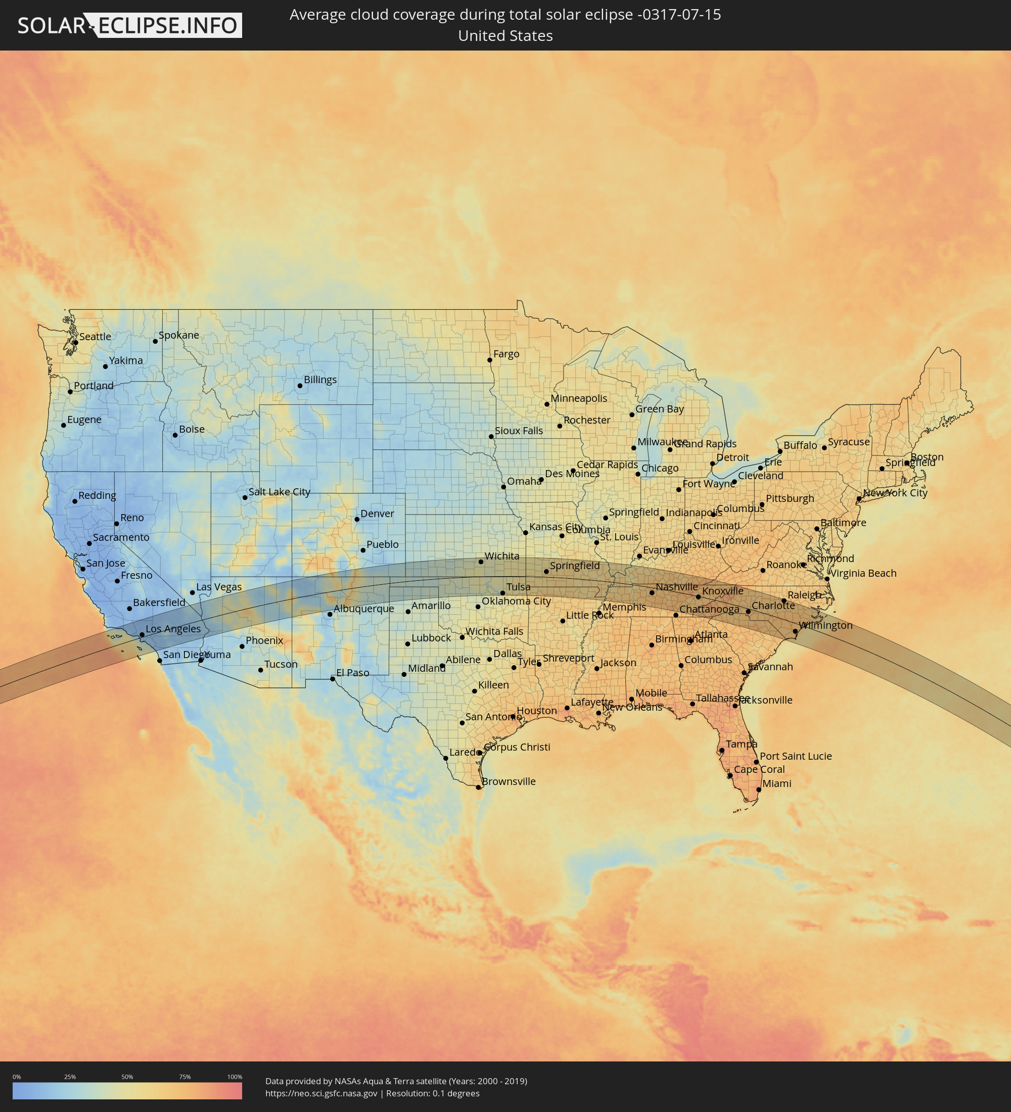 United States
Cities inside the path of the eclipse
The following table shows all locations with a population of more than 5,000 inside the eclipse path. Cities which have more than 100,000 inhabitants are marked bold. A click at the locations opens a detailed map.
| City | Type | Eclipse duration | Local time of max. eclipse | Distance to central line | Ø Cloud coverage |
|
Santa Barbara, California
|
total | - | 07:44:41 UTC-08:00 | 89 km | 41% |
|
Carpinteria, California
|
total | - | 07:44:49 UTC-08:00 | 81 km | 38% |
|
Oxnard, California
|
total | - | 07:44:57 UTC-08:00 | 50 km | 43% |
|
Santa Paula, California
|
total | - | 07:45:11 UTC-08:00 | 64 km | 15% |
|
Thousand Oaks, California
|
total | - | 07:45:14 UTC-08:00 | 38 km | 11% |
|
Malibu Beach, California
|
total | - | 07:45:15 UTC-08:00 | 20 km | 37% |
|
West Hills, California
|
total | - | 07:45:26 UTC-08:00 | 36 km | 11% |
|
Santa Clarita, California
|
total | - | 07:45:42 UTC-08:00 | 54 km | 11% |
|
Santa Monica, California
|
total | - | 07:45:25 UTC-08:00 | 13 km | 33% |
|
Van Nuys, California
|
total | - | 07:45:36 UTC-08:00 | 29 km | 13% |
|
Torrance, California
|
total | - | 07:45:24 UTC-08:00 | 11 km | 28% |
|
Los Angeles, California
|
total | - | 07:45:41 UTC-08:00 | 9 km | 12% |
|
Long Beach, California
|
total | - | 07:45:29 UTC-08:00 | 22 km | 31% |
|
Rosamond, California
|
total | - | 07:46:28 UTC-08:00 | 94 km | 9% |
|
Lancaster, California
|
total | - | 07:46:21 UTC-08:00 | 75 km | 12% |
|
Downey, California
|
total | - | 07:45:41 UTC-08:00 | 6 km | 14% |
|
Altadena, California
|
total | - | 07:45:55 UTC-08:00 | 21 km | 14% |
|
Vincent, California
|
total | - | 07:46:12 UTC-08:00 | 54 km | 13% |
|
El Monte, California
|
total | - | 07:45:54 UTC-08:00 | 5 km | 14% |
|
Huntington Beach, California
|
total | - | 07:45:35 UTC-08:00 | 39 km | 33% |
|
Anaheim, California
|
total | - | 07:45:49 UTC-08:00 | 23 km | 15% |
|
Rowland Heights, California
|
total | - | 07:45:56 UTC-08:00 | 8 km | 14% |
|
Lake Los Angeles, California
|
total | - | 07:46:34 UTC-08:00 | 58 km | 11% |
|
Irvine, California
|
total | - | 07:45:45 UTC-08:00 | 43 km | 18% |
|
Pomona, California
|
total | - | 07:46:09 UTC-08:00 | 3 km | 14% |
|
Mission Viejo, California
|
total | - | 07:45:51 UTC-08:00 | 54 km | 22% |
|
San Clemente, California
|
total | - | 07:45:45 UTC-08:00 | 74 km | 40% |
|
Rancho Cucamonga, California
|
total | - | 07:46:21 UTC-08:00 | 2 km | 12% |
|
Phelan, California
|
total | - | 07:46:39 UTC-08:00 | 31 km | 17% |
|
Corona, California
|
total | - | 07:46:11 UTC-08:00 | 28 km | 13% |
|
Riverside, California
|
total | - | 07:46:25 UTC-08:00 | 24 km | 12% |
|
Lake Elsinore, California
|
total | - | 07:46:14 UTC-08:00 | 56 km | 12% |
|
Victorville, California
|
total | - | 07:47:01 UTC-08:00 | 36 km | 12% |
|
San Bernardino, California
|
total | - | 07:46:39 UTC-08:00 | 10 km | 13% |
|
Fallbrook, California
|
total | - | 07:46:04 UTC-08:00 | 89 km | 16% |
|
Moreno Valley, California
|
total | - | 07:46:34 UTC-08:00 | 30 km | 13% |
|
Murrieta, California
|
total | - | 07:46:15 UTC-08:00 | 71 km | 13% |
|
Lake Arrowhead, California
|
total | - | 07:46:53 UTC-08:00 | 2 km | 15% |
|
Menifee, California
|
total | - | 07:46:28 UTC-08:00 | 54 km | 12% |
|
Barstow Heights, California
|
total | - | 07:47:33 UTC-08:00 | 65 km | 13% |
|
Yucaipa, California
|
total | - | 07:46:50 UTC-08:00 | 25 km | 13% |
|
Hemet, California
|
total | - | 07:46:40 UTC-08:00 | 57 km | 12% |
|
Banning, California
|
total | - | 07:46:55 UTC-08:00 | 40 km | 12% |
|
Big Bear City, California
|
total | - | 07:47:14 UTC-08:00 | 5 km | 39% |
|
Desert Hot Springs, California
|
total | - | 07:47:20 UTC-08:00 | 46 km | 13% |
|
Cathedral City, California
|
total | - | 07:47:13 UTC-08:00 | 67 km | 19% |
|
Yucca Valley, California
|
total | - | 07:47:32 UTC-08:00 | 32 km | 14% |
|
Indio, California
|
total | - | 07:47:25 UTC-08:00 | 79 km | 18% |
|
Twentynine Palms, California
|
total | - | 07:47:56 UTC-08:00 | 39 km | 18% |
|
Bullhead City, Arizona
|
total | - | 08:50:24 UTC-07:00 | 33 km | 21% |
|
Lake Havasu City, Arizona
|
total | - | 08:50:07 UTC-07:00 | 44 km | 19% |
|
Kingman, Arizona
|
total | - | 08:51:00 UTC-07:00 | 26 km | 27% |
|
Prescott, Arizona
|
total | - | 08:52:20 UTC-07:00 | 80 km | 48% |
|
Chino Valley, Arizona
|
total | - | 08:52:31 UTC-07:00 | 57 km | 40% |
|
Prescott Valley, Arizona
|
total | - | 08:52:34 UTC-07:00 | 76 km | 46% |
|
Verde Village, Arizona
|
total | - | 08:53:01 UTC-07:00 | 71 km | 44% |
|
Camp Verde, Arizona
|
total | - | 08:53:06 UTC-07:00 | 90 km | 43% |
|
West Sedona, Arizona
|
total | - | 08:53:24 UTC-07:00 | 59 km | 41% |
|
Flagstaff, Arizona
|
total | - | 08:53:51 UTC-07:00 | 26 km | 59% |
|
Gallup, New Mexico
|
total | - | 08:57:54 UTC-07:00 | 46 km | 41% |
|
Farmington, New Mexico
|
total | - | 08:59:29 UTC-07:00 | 77 km | 17% |
|
Los Alamos, New Mexico
|
total | - | 09:01:37 UTC-07:00 | 45 km | 48% |
|
Santa Fe, New Mexico
|
total | - | 09:02:03 UTC-07:00 | 73 km | 47% |
|
Las Vegas, New Mexico
|
total | - | 09:03:04 UTC-07:00 | 93 km | 39% |
|
Dumas, Texas
|
total | - | 10:08:27 UTC-06:00 | 99 km | 36% |
|
Guymon, Oklahoma
|
total | - | 10:09:41 UTC-06:00 | 13 km | 33% |
|
Liberal, Kansas
|
total | - | 10:10:48 UTC-06:00 | 23 km | 35% |
|
Dodge City, Kansas
|
total | - | 10:12:39 UTC-06:00 | 95 km | 35% |
|
Woodward, Oklahoma
|
total | - | 10:13:10 UTC-06:00 | 55 km | 40% |
|
Enid, Oklahoma
|
total | - | 10:15:52 UTC-06:00 | 66 km | 41% |
|
Wichita, Kansas
|
total | - | 10:17:17 UTC-06:00 | 77 km | 45% |
|
Derby, Kansas
|
total | - | 10:17:21 UTC-06:00 | 61 km | 45% |
|
Andover, Kansas
|
total | - | 10:17:39 UTC-06:00 | 79 km | 43% |
|
Ponca City, Oklahoma
|
total | - | 10:17:26 UTC-06:00 | 33 km | 42% |
|
Stillwater, Oklahoma
|
total | - | 10:17:18 UTC-06:00 | 99 km | 42% |
|
Arkansas City, Kansas
|
total | - | 10:17:37 UTC-06:00 | 6 km | 39% |
|
Winfield, Kansas
|
total | - | 10:17:45 UTC-06:00 | 26 km | 41% |
|
El Dorado, Kansas
|
total | - | 10:18:10 UTC-06:00 | 90 km | 44% |
|
Tulsa, Oklahoma
|
total | - | 10:19:20 UTC-06:00 | 96 km | 48% |
|
Bartlesville, Oklahoma
|
total | - | 10:19:30 UTC-06:00 | 30 km | 47% |
|
Owasso, Oklahoma
|
total | - | 10:19:37 UTC-06:00 | 83 km | 50% |
|
Claremore, Oklahoma
|
total | - | 10:20:05 UTC-06:00 | 78 km | 51% |
|
Parsons, Kansas
|
total | - | 10:20:59 UTC-06:00 | 36 km | 53% |
|
Miami, Oklahoma
|
total | - | 10:21:37 UTC-06:00 | 15 km | 55% |
|
Pittsburg, Kansas
|
total | - | 10:22:03 UTC-06:00 | 45 km | 52% |
|
Siloam Springs, Arkansas
|
total | - | 10:22:09 UTC-06:00 | 91 km | 58% |
|
Joplin, Missouri
|
total | - | 10:22:21 UTC-06:00 | 9 km | 58% |
|
Neosho, Missouri
|
total | - | 10:22:36 UTC-06:00 | 15 km | 58% |
|
Carthage, Missouri
|
total | - | 10:22:45 UTC-06:00 | 19 km | 56% |
|
Bella Vista, Arkansas
|
total | - | 10:22:43 UTC-06:00 | 58 km | 56% |
|
Springdale, Arkansas
|
total | - | 10:22:57 UTC-06:00 | 90 km | 64% |
|
Rogers, Arkansas
|
total | - | 10:23:00 UTC-06:00 | 74 km | 59% |
|
Republic, Missouri
|
total | - | 10:24:21 UTC-06:00 | 15 km | 60% |
|
Bolivar, Missouri
|
total | - | 10:24:33 UTC-06:00 | 71 km | 54% |
|
Springfield, Missouri
|
total | - | 10:24:43 UTC-06:00 | 27 km | 63% |
|
Nixa, Missouri
|
total | - | 10:24:42 UTC-06:00 | 8 km | 62% |
|
Branson, Missouri
|
total | - | 10:24:49 UTC-06:00 | 37 km | 60% |
|
Harrison, Arkansas
|
total | - | 10:24:59 UTC-06:00 | 82 km | 68% |
|
Lebanon, Missouri
|
total | - | 10:26:00 UTC-06:00 | 81 km | 58% |
|
Mountain Home, Arkansas
|
total | - | 10:26:27 UTC-06:00 | 67 km | 63% |
|
Fort Leonard Wood, Missouri
|
total | - | 10:26:59 UTC-06:00 | 86 km | 59% |
|
West Plains, Missouri
|
total | - | 10:27:32 UTC-06:00 | 20 km | 64% |
|
Paragould, Arkansas
|
total | - | 10:30:19 UTC-06:00 | 85 km | 60% |
|
Poplar Bluff, Missouri
|
total | - | 10:30:30 UTC-06:00 | 7 km | 61% |
|
Kennett, Missouri
|
total | - | 10:31:14 UTC-06:00 | 62 km | 61% |
|
Blytheville, Arkansas
|
total | - | 10:31:33 UTC-06:00 | 95 km | 62% |
|
Jackson, Missouri
|
total | - | 10:31:56 UTC-06:00 | 69 km | 62% |
|
Sikeston, Missouri
|
total | - | 10:32:08 UTC-06:00 | 14 km | 64% |
|
Cape Girardeau, Missouri
|
total | - | 10:32:14 UTC-06:00 | 62 km | 54% |
|
Dyersburg, Tennessee
|
total | - | 10:32:39 UTC-06:00 | 78 km | 67% |
|
Union City, Tennessee
|
total | - | 10:33:17 UTC-06:00 | 31 km | 60% |
|
Martin, Tennessee
|
total | - | 10:33:44 UTC-06:00 | 38 km | 62% |
|
Paducah, Kentucky
|
total | - | 10:34:09 UTC-06:00 | 47 km | 57% |
|
Murray, Kentucky
|
total | - | 10:34:49 UTC-06:00 | 2 km | 62% |
|
Madisonville, Kentucky
|
total | - | 10:36:22 UTC-06:00 | 87 km | 61% |
|
Hopkinsville, Kentucky
|
total | - | 10:36:29 UTC-06:00 | 36 km | 66% |
|
Fort Campbell North, Kentucky
|
total | - | 10:36:36 UTC-06:00 | 13 km | 67% |
|
Dickson, Tennessee
|
total | - | 10:36:53 UTC-06:00 | 49 km | 72% |
|
Clarksville, Tennessee
|
total | - | 10:36:51 UTC-06:00 | 1 km | 65% |
|
Columbia, Tennessee
|
total | - | 10:37:46 UTC-06:00 | 95 km | 71% |
|
Spring Hill, Tennessee
|
total | - | 10:37:58 UTC-06:00 | 79 km | 71% |
|
Springfield, Tennessee
|
total | - | 10:37:51 UTC-06:00 | 5 km | 71% |
|
Franklin, Tennessee
|
total | - | 10:38:03 UTC-06:00 | 59 km | 72% |
|
Nashville, Tennessee
|
total | - | 10:38:10 UTC-06:00 | 31 km | 75% |
|
Hendersonville, Tennessee
|
total | - | 10:38:28 UTC-06:00 | 14 km | 69% |
|
Smyrna, Tennessee
|
total | - | 10:38:47 UTC-06:00 | 47 km | 74% |
|
Portland, Tennessee
|
total | - | 10:38:37 UTC-06:00 | 18 km | 69% |
|
Shelbyville, Tennessee
|
total | - | 10:39:04 UTC-06:00 | 101 km | 73% |
|
Gallatin, Tennessee
|
total | - | 10:38:49 UTC-06:00 | 2 km | 63% |
|
Bowling Green, Kentucky
|
total | - | 10:38:39 UTC-06:00 | 64 km | 69% |
|
Murfreesboro, Tennessee
|
total | - | 10:39:06 UTC-06:00 | 61 km | 75% |
|
Lebanon, Tennessee
|
total | - | 10:39:12 UTC-06:00 | 19 km | 75% |
|
Glasgow, Kentucky
|
total | - | 10:39:46 UTC-06:00 | 73 km | 69% |
|
McMinnville, Tennessee
|
total | - | 10:40:30 UTC-06:00 | 69 km | 73% |
|
Cookeville, Tennessee
|
total | - | 10:40:55 UTC-06:00 | 12 km | 75% |
|
Crossville, Tennessee
|
total | - | 10:42:02 UTC-06:00 | 27 km | 76% |
|
Somerset, Kentucky
|
total | - | 11:42:29 UTC-05:00 | 105 km | 67% |
|
Athens, Tennessee
|
total | - | 11:43:11 UTC-05:00 | 75 km | 68% |
|
Oak Ridge, Tennessee
|
total | - | 11:43:39 UTC-05:00 | 7 km | 68% |
|
Farragut, Tennessee
|
total | - | 11:43:57 UTC-05:00 | 18 km | 66% |
|
Maryville, Tennessee
|
total | - | 11:44:25 UTC-05:00 | 29 km | 71% |
|
Knoxville, Tennessee
|
total | - | 11:44:26 UTC-05:00 | 6 km | 69% |
|
Middlesboro, Kentucky
|
total | - | 11:44:34 UTC-05:00 | 69 km | 76% |
|
Sevierville, Tennessee
|
total | - | 11:45:15 UTC-05:00 | 9 km | 69% |
|
Morristown, Tennessee
|
total | - | 11:45:40 UTC-05:00 | 34 km | 72% |
|
Greeneville, Tennessee
|
total | - | 11:46:42 UTC-05:00 | 38 km | 73% |
|
Easley, South Carolina
|
total | - | 11:47:56 UTC-05:00 | 101 km | 74% |
|
Kingsport, Tennessee
|
total | - | 11:47:05 UTC-05:00 | 85 km | 71% |
|
Asheville, North Carolina
|
total | - | 11:47:36 UTC-05:00 | 17 km | 69% |
|
Hendersonville, North Carolina
|
total | - | 11:47:58 UTC-05:00 | 45 km | 74% |
|
Greenville, South Carolina
|
total | - | 11:48:23 UTC-05:00 | 94 km | 78% |
|
Johnson City, Tennessee
|
total | - | 11:47:39 UTC-05:00 | 64 km | 71% |
|
Simpsonville, South Carolina
|
total | - | 11:48:46 UTC-05:00 | 104 km | 71% |
|
Greer, South Carolina
|
total | - | 11:48:42 UTC-05:00 | 81 km | 74% |
|
Bristol, Tennessee
|
total | - | 11:47:51 UTC-05:00 | 98 km | 73% |
|
Spartanburg, South Carolina
|
total | - | 11:49:21 UTC-05:00 | 73 km | 68% |
|
Morganton, North Carolina
|
total | - | 11:49:26 UTC-05:00 | 18 km | 69% |
|
Boone, North Carolina
|
total | - | 11:49:10 UTC-05:00 | 69 km | 77% |
|
Gaffney, South Carolina
|
total | - | 11:49:55 UTC-05:00 | 54 km | 67% |
|
Lenoir, North Carolina
|
total | - | 11:49:39 UTC-05:00 | 40 km | 70% |
|
Shelby, North Carolina
|
total | - | 11:50:02 UTC-05:00 | 27 km | 70% |
|
Hickory, North Carolina
|
total | - | 11:50:11 UTC-05:00 | 25 km | 70% |
|
Lincolnton, North Carolina
|
total | - | 11:50:32 UTC-05:00 | 1 km | 68% |
|
Gastonia, North Carolina
|
total | - | 11:50:49 UTC-05:00 | 22 km | 72% |
|
Rock Hill, South Carolina
|
total | - | 11:51:24 UTC-05:00 | 55 km | 71% |
|
Mount Holly, North Carolina
|
total | - | 11:51:11 UTC-05:00 | 14 km | 67% |
|
Statesville, North Carolina
|
total | - | 11:51:09 UTC-05:00 | 41 km | 70% |
|
Charlotte, North Carolina
|
total | - | 11:51:36 UTC-05:00 | 18 km | 76% |
|
Huntersville, North Carolina
|
total | - | 11:51:29 UTC-05:00 | 2 km | 73% |
|
Mooresville, North Carolina
|
total | - | 11:51:27 UTC-05:00 | 21 km | 66% |
|
Indian Trail, North Carolina
|
total | - | 11:52:06 UTC-05:00 | 30 km | 73% |
|
Concord, North Carolina
|
total | - | 11:52:04 UTC-05:00 | 8 km | 73% |
|
Salisbury, North Carolina
|
total | - | 11:52:07 UTC-05:00 | 39 km | 69% |
|
Clemmons, North Carolina
|
total | - | 11:52:05 UTC-05:00 | 79 km | 67% |
|
Lexington, North Carolina
|
total | - | 11:52:30 UTC-05:00 | 61 km | 61% |
|
Winston-Salem, North Carolina
|
total | - | 11:52:20 UTC-05:00 | 91 km | 67% |
|
Albemarle, North Carolina
|
total | - | 11:52:57 UTC-05:00 | 12 km | 70% |
|
Kernersville, North Carolina
|
total | - | 11:52:42 UTC-05:00 | 97 km | 69% |
|
High Point, North Carolina
|
total | - | 11:52:57 UTC-05:00 | 81 km | 72% |
|
Asheboro, North Carolina
|
total | - | 11:53:32 UTC-05:00 | 60 km | 68% |
|
Greensboro, North Carolina
|
total | - | 11:53:20 UTC-05:00 | 99 km | 72% |
|
Florence, South Carolina
|
total | - | 11:54:46 UTC-05:00 | 100 km | 74% |
|
Pinehurst, North Carolina
|
total | - | 11:54:40 UTC-05:00 | 14 km | 73% |
|
Laurinburg, North Carolina
|
total | - | 11:55:00 UTC-05:00 | 31 km | 74% |
|
Sanford, North Carolina
|
total | - | 11:55:05 UTC-05:00 | 52 km | 69% |
|
Chapel Hill, North Carolina
|
total | - | 11:55:02 UTC-05:00 | 102 km | 67% |
|
Lumberton, North Carolina
|
total | - | 11:56:08 UTC-05:00 | 35 km | 73% |
|
Fort Bragg, North Carolina
|
total | - | 11:55:44 UTC-05:00 | 21 km | 77% |
|
Fayetteville, North Carolina
|
total | - | 11:56:05 UTC-05:00 | 15 km | 76% |
|
Apex, North Carolina
|
total | - | 11:55:37 UTC-05:00 | 88 km | 65% |
|
Fuquay-Varina, North Carolina
|
total | - | 11:55:50 UTC-05:00 | 74 km | 72% |
|
Raleigh, North Carolina
|
total | - | 11:56:03 UTC-05:00 | 98 km | 74% |
|
Clayton, North Carolina
|
total | - | 11:56:32 UTC-05:00 | 90 km | 71% |
|
Smithfield, North Carolina
|
total | - | 11:56:54 UTC-05:00 | 78 km | 66% |
|
Goldsboro, North Carolina
|
total | - | 11:57:45 UTC-05:00 | 75 km | 69% |
|
Wilmington, North Carolina
|
total | - | 11:58:50 UTC-05:00 | 46 km | 70% |
|
Kinston, North Carolina
|
total | - | 11:58:45 UTC-05:00 | 74 km | 71% |
|
Jacksonville, North Carolina
|
total | - | 11:59:31 UTC-05:00 | 25 km | 71% |
|
New Bern, North Carolina
|
total | - | 12:00:03 UTC-05:00 | 74 km | 66% |
|
Havelock, North Carolina
|
total | - | 12:00:34 UTC-05:00 | 55 km | 70% |