Hybrid solar eclipse of 01/05/-0465
| Day of week: | Friday |
| Maximum duration of eclipse: | 01m20s |
| Maximum width of eclipse path: | 49 km |
| Saros cycle: | 53 |
| Coverage: | 100% |
| Magnitude: | 1.0141 |
| Gamma: | -0.1117 |
Wo kann man die Sonnenfinsternis vom 01/05/-0465 sehen?
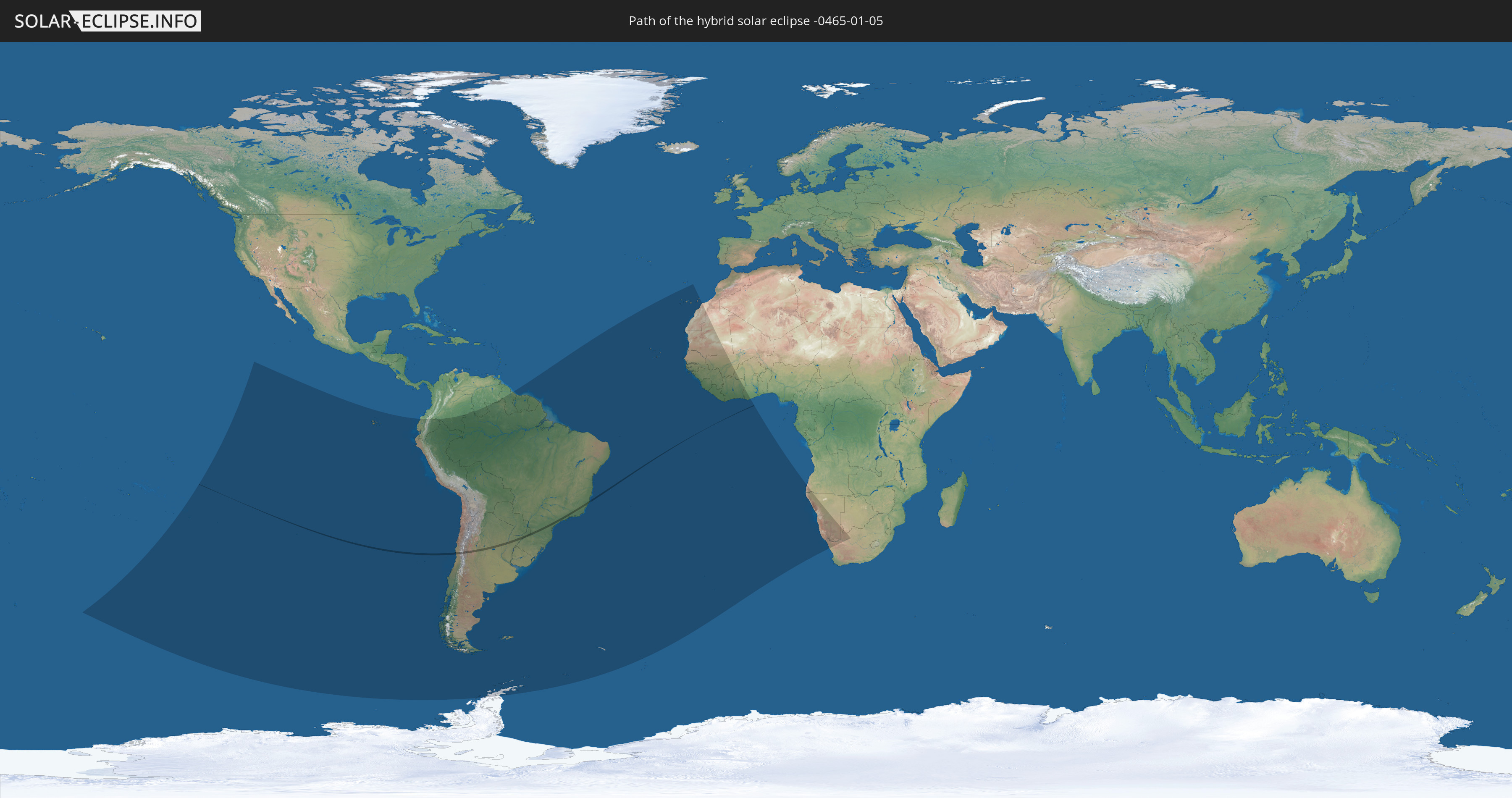
Die Sonnenfinsternis am 01/05/-0465 kann man in 38 Ländern als partielle Sonnenfinsternis beobachten.
Der Finsternispfad verläuft durch 3 Länder. Nur in diesen Ländern ist sie als hybrid Sonnenfinsternis zu sehen.
In den folgenden Ländern ist die Sonnenfinsternis hybrid zu sehen
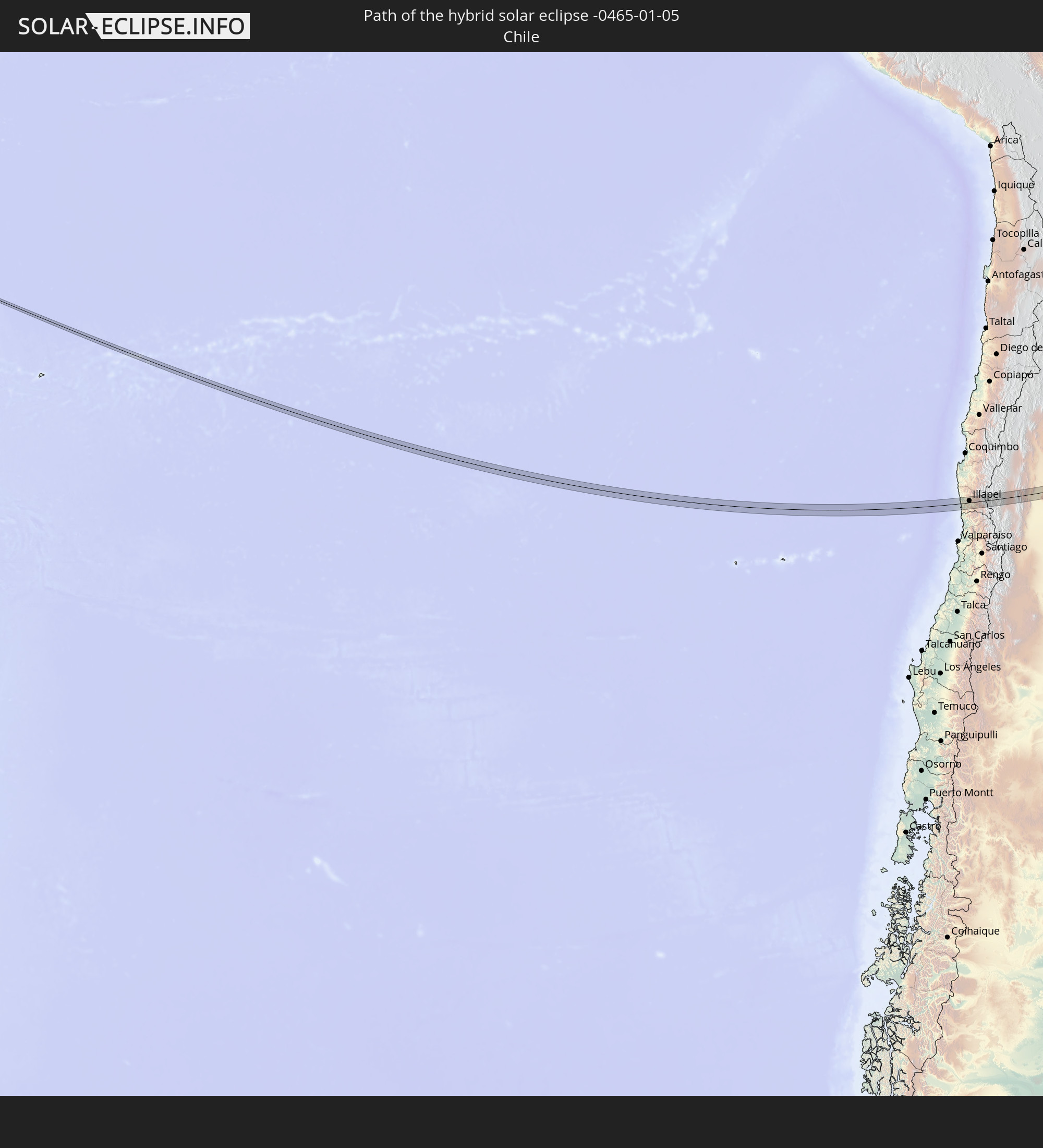 Chile
Chile
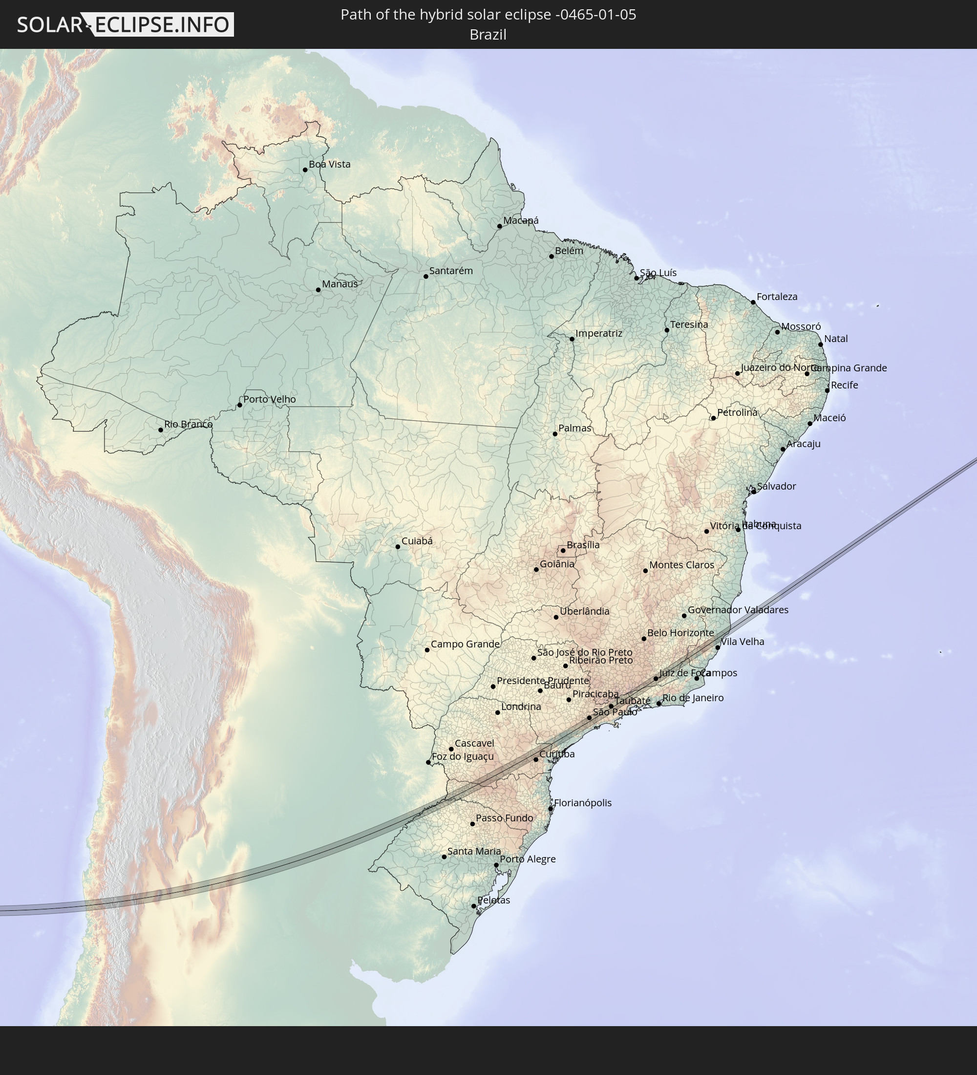 Brazil
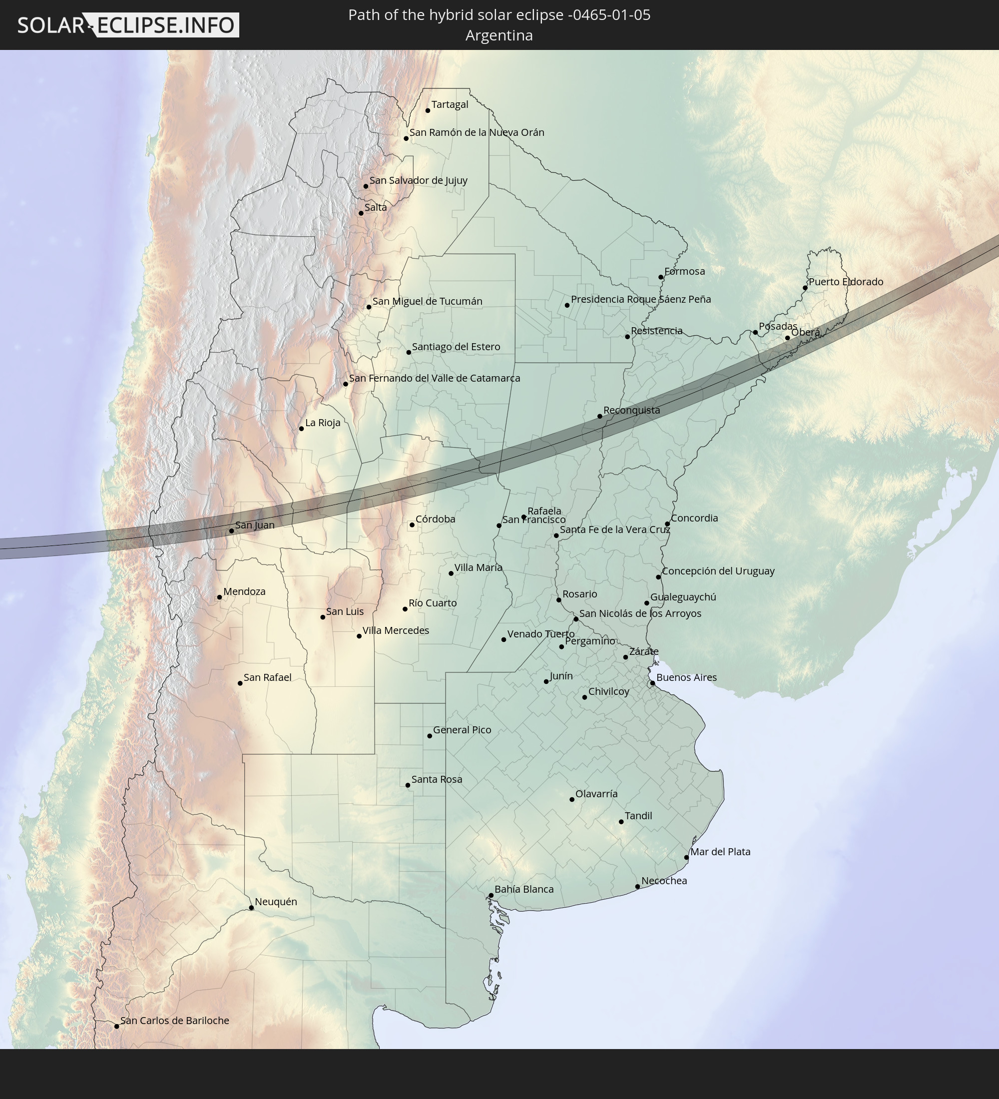 Argentina
In den folgenden Ländern ist die Sonnenfinsternis partiell zu sehen
 Antarctica
 French Polynesia
 Pitcairn Islands
 Chile
Chile
 Ecuador
 Colombia
 Peru
Peru
 Brazil
 Argentina
 Venezuela
 Bolivia
 Paraguay
 Falkland Islands
 Guyana
 Uruguay
 Suriname
 French Guiana
 South Georgia and the South Sandwich Islands
 Portugal
 Cabo Verde
 Spain
Spain
 Senegal
 Mauritania
 The Gambia
 Guinea-Bissau
 Guinea
 Saint Helena, Ascension and Tristan da Cunha
 Sierra Leone
 Morocco
 Mali
Mali
 Liberia
 Ivory Coast
 Burkina Faso
 Ghana
Ghana
 Angola
 Namibia
 South Africa
 Botswana
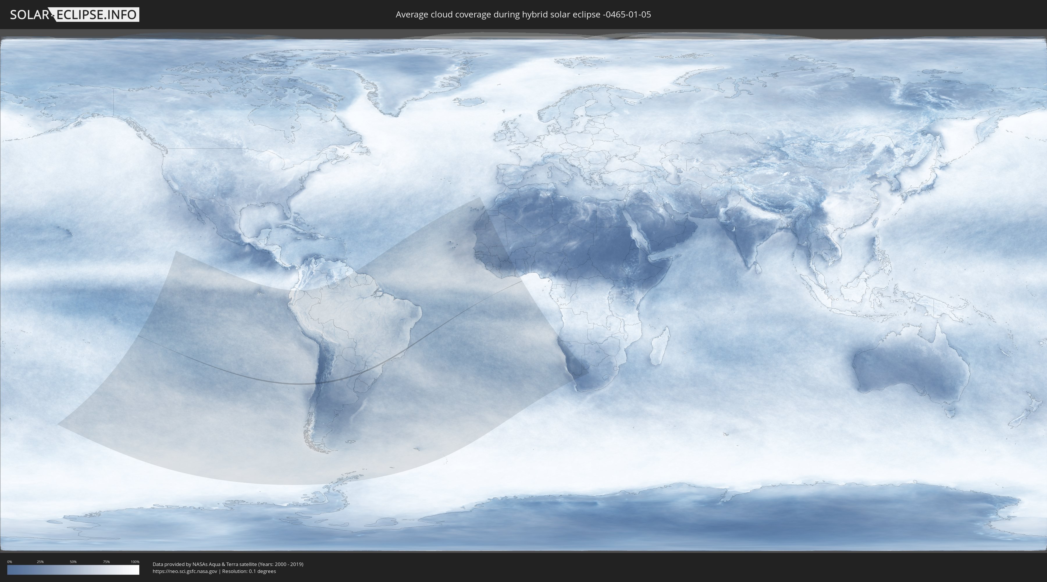
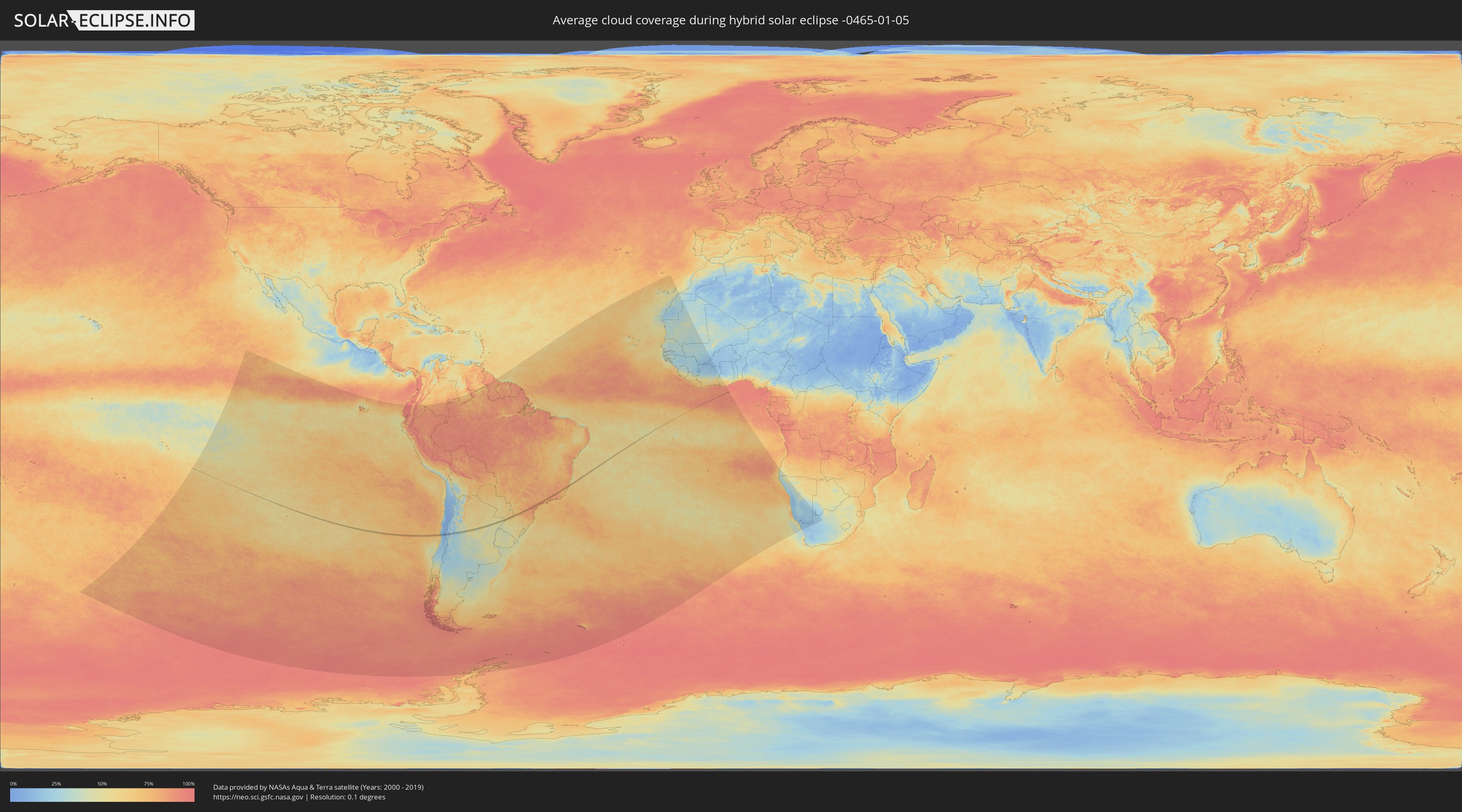
How will be the weather during the hybrid solar eclipse on 01/05/-0465?
Where is the best place to see the hybrid solar eclipse of 01/05/-0465?
The following maps show the average cloud coverage for the day of the hybrid solar eclipse.
With the help of these maps, it is possible to find the place along the eclipse path, which has the best
chance of a cloudless sky.
Nevertheless, you should consider local circumstances and inform about the weather of your chosen
observation site.
The data is provided by NASAs satellites
AQUA and TERRA.
The cloud maps are averaged over a period of 19 years (2000 - 2019).
Detailed country maps
 Chile
Chile
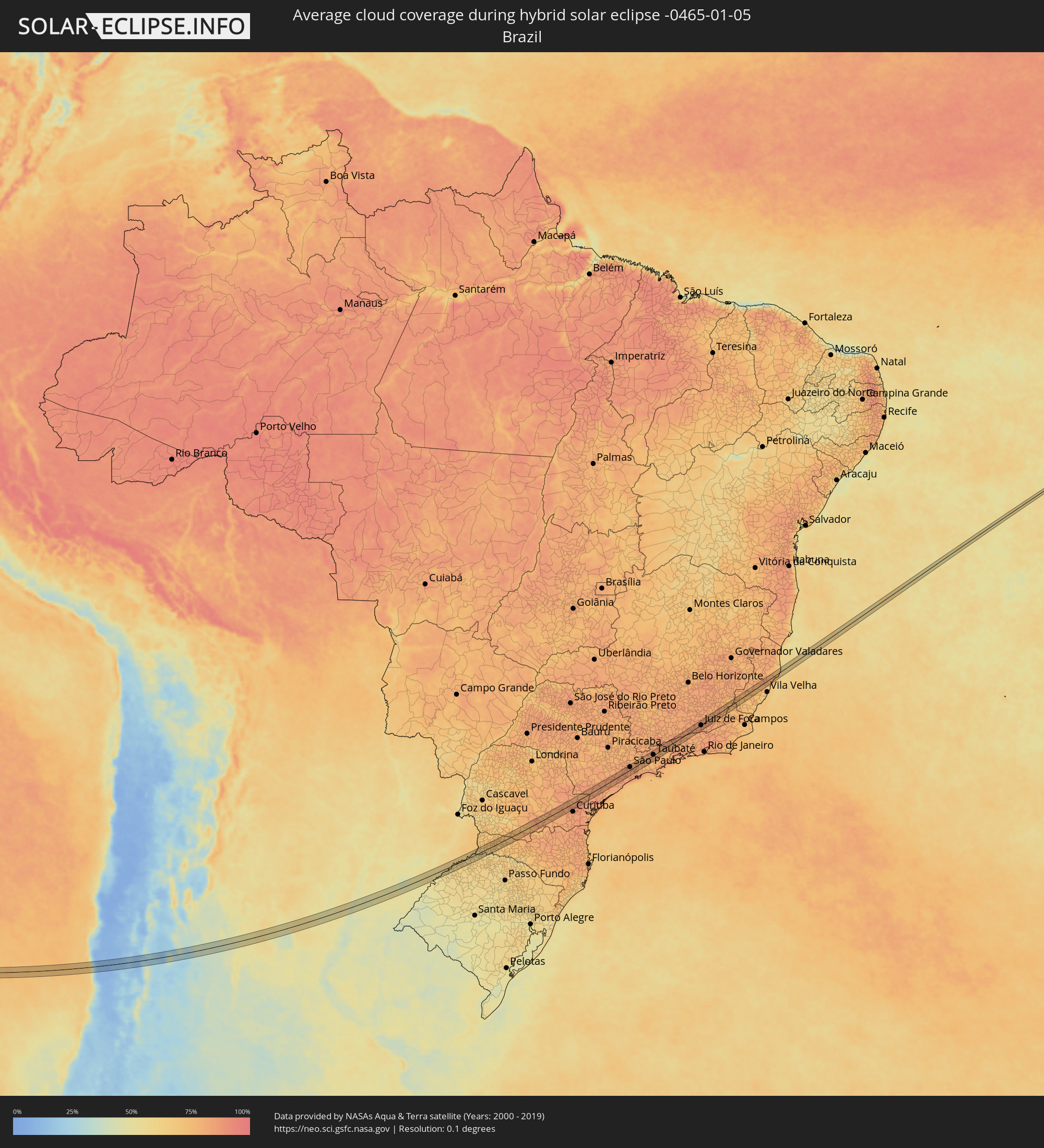 Brazil
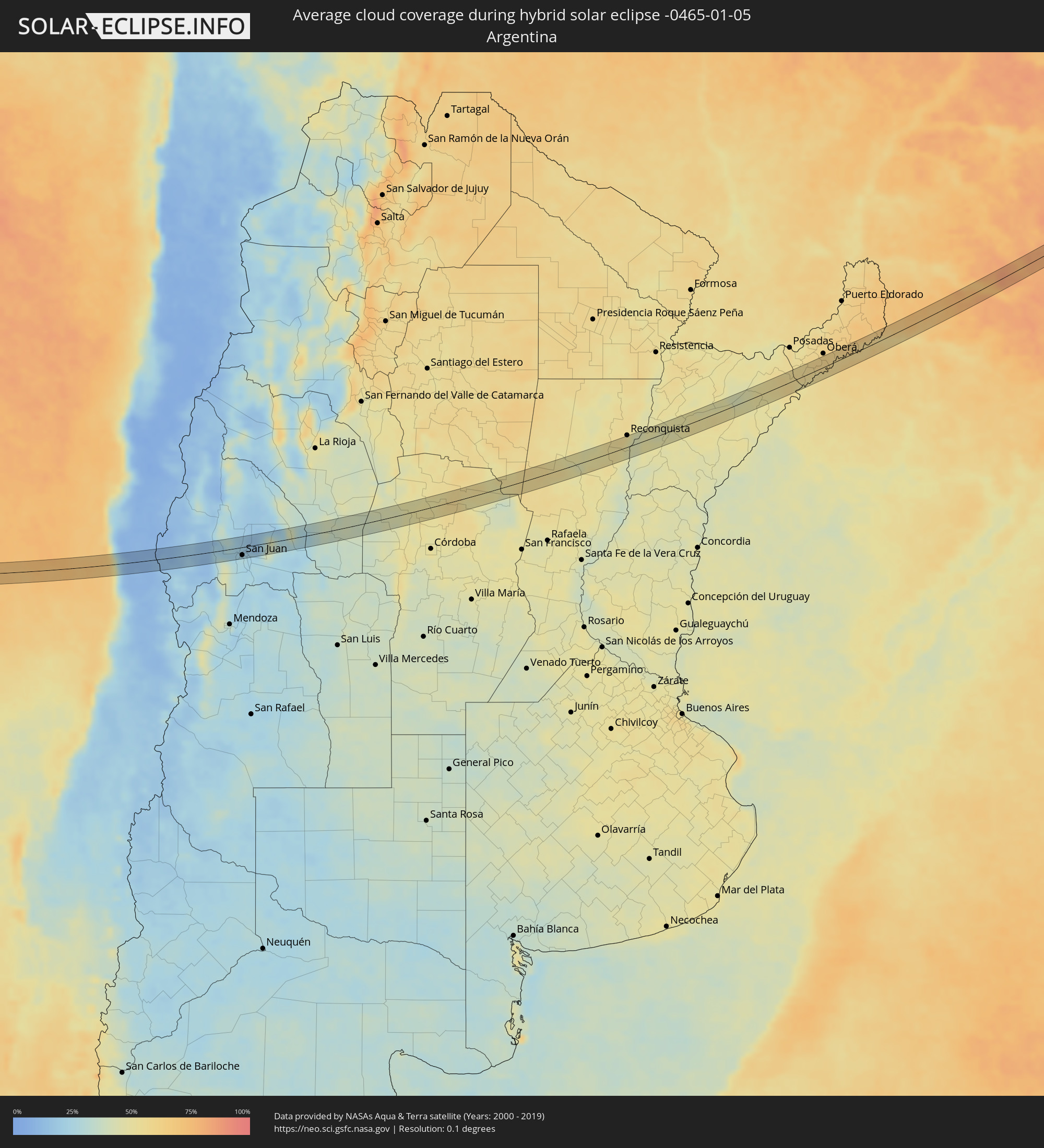 Argentina
Cities inside the path of the eclipse
The following table shows all locations with a population of more than 5,000 inside the eclipse path. Cities which have more than 100,000 inhabitants are marked bold. A click at the locations opens a detailed map.
| City | Type | Eclipse duration | Local time of max. eclipse | Distance to central line | Ø Cloud coverage |
|
Illapel, Coquimbo
|
total | - | 11:09:34 UTC-04:42 | 6 km | 10% |
|
Salamanca, Coquimbo
|
total | - | 11:10:03 UTC-04:42 | 12 km | 11% |
|
Calingasta, San Juan Province
|
total | - | 11:40:03 UTC-04:16 | 18 km | 13% |
|
Villa Paula de Sarmiento, San Juan Province
|
total | - | 11:42:11 UTC-04:16 | 12 km | 27% |
|
San Juan, San Juan Province
|
total | - | 11:42:10 UTC-04:16 | 17 km | 27% |
|
Chimbas, San Juan Province
|
total | - | 11:42:12 UTC-04:16 | 11 km | 27% |
|
Albardón, San Juan Province
|
total | - | 11:42:14 UTC-04:16 | 6 km | 23% |
|
San Martín, San Juan Province
|
total | - | 11:42:18 UTC-04:16 | 6 km | 23% |
|
Santa Lucía, San Juan Province
|
total | - | 11:42:16 UTC-04:16 | 18 km | 27% |
|
Villa de Soto, Cordoba Province
|
total | - | 11:51:32 UTC-04:16 | 9 km | 44% |
|
Cruz del Eje, Cordoba Province
|
total | - | 11:52:07 UTC-04:16 | 0 km | 47% |
|
Capilla del Monte, Cordoba Province
|
total | - | 11:52:44 UTC-04:16 | 21 km | 50% |
|
Deán Funes, Cordoba Province
|
total | - | 11:53:30 UTC-04:16 | 23 km | 50% |
|
Ceres, Santa Fe Province
|
total | - | 12:00:07 UTC-04:16 | 18 km | 55% |
|
Vera, Santa Fe Province
|
total | - | 12:04:55 UTC-04:16 | 10 km | 50% |
|
Malabrigo, Santa Fe Province
|
total | - | 12:05:39 UTC-04:16 | 14 km | 53% |
|
Goya, Corrientes Province
|
total | - | 12:07:38 UTC-04:16 | 13 km | 46% |
|
Santa Lucía, Corrientes Province
|
total | - | 12:08:13 UTC-04:16 | 23 km | 47% |
|
Gobernador Ingeniero Valentín Virasoro, Corrientes Province
|
total | - | 12:16:54 UTC-04:16 | 8 km | 57% |
|
Concepción de la Sierra, Misiones Province
|
total | - | 12:18:13 UTC-04:16 | 6 km | 52% |
|
Panambí, Misiones Province
|
total | - | 12:20:00 UTC-04:16 | 4 km | 57% |
|
Alba Posse, Misiones Province
|
total | - | 12:20:45 UTC-04:16 | 2 km | 61% |
|
Colonia Aurora, Misiones Province
|
total | - | 12:21:15 UTC-04:16 | 5 km | 61% |
|
Horizontina, Rio Grande do Sul
|
total | - | 13:31:54 UTC-03:06 | 19 km | 63% |
|
El Soberbio, Misiones Province
|
total | - | 12:22:15 UTC-04:16 | 9 km | 58% |
|
Três Passos, Rio Grande do Sul
|
total | - | 13:33:00 UTC-03:06 | 18 km | 64% |
|
Clevelândia, Paraná
|
total | - | 13:37:51 UTC-03:06 | 23 km | 71% |
|
Palmas, Paraná
|
total | - | 13:38:49 UTC-03:06 | 7 km | 76% |
|
Palmeira, Paraná
|
total | - | 13:44:45 UTC-03:06 | 2 km | 80% |
|
Itaperuçu, Paraná
|
total | - | 13:46:29 UTC-03:06 | 10 km | 87% |
|
Rio Branco do Sul, Paraná
|
total | - | 13:46:36 UTC-03:06 | 9 km | 87% |
|
Almirante Tamandaré, Paraná
|
total | - | 13:46:25 UTC-03:06 | 22 km | 85% |
|
Registro, São Paulo
|
total | - | 13:50:45 UTC-03:06 | 16 km | 80% |
|
Juquiá, São Paulo
|
total | - | 13:51:26 UTC-03:06 | 10 km | 82% |
|
Miracatu, São Paulo
|
total | - | 13:51:51 UTC-03:06 | 16 km | 82% |
|
Juquitiba, São Paulo
|
total | - | 13:53:11 UTC-03:06 | 3 km | 84% |
|
São Lourenço da Serra, São Paulo
|
total | - | 13:53:33 UTC-03:06 | 2 km | 84% |
|
Cotia, São Paulo
|
total | - | 13:53:59 UTC-03:06 | 20 km | 82% |
|
Embu, São Paulo
|
total | - | 13:54:03 UTC-03:06 | 13 km | 82% |
|
Itapecerica da Serra, São Paulo
|
total | - | 13:53:57 UTC-03:06 | 6 km | 82% |
|
Embu Guaçu, São Paulo
|
total | - | 13:53:51 UTC-03:06 | 7 km | 84% |
|
Taboão da Serra, São Paulo
|
total | - | 13:54:12 UTC-03:06 | 12 km | 82% |
|
Osasco, São Paulo
|
total | - | 13:54:21 UTC-03:06 | 21 km | 83% |
|
São Paulo, São Paulo
|
total | - | 13:54:38 UTC-03:06 | 11 km | 84% |
|
São Bernardo do Campo, São Paulo
|
total | - | 13:54:33 UTC-03:06 | 7 km | 81% |
|
São Caetano do Sul, São Paulo
|
total | - | 13:54:42 UTC-03:06 | 1 km | 82% |
|
Ribeirão Pires, São Paulo
|
total | - | 13:54:50 UTC-03:06 | 16 km | 82% |
|
Rio Grande da Serra, São Paulo
|
total | - | 13:54:48 UTC-03:06 | 20 km | 82% |
|
Ferraz de Vasconcelos, São Paulo
|
total | - | 13:55:11 UTC-03:06 | 3 km | 82% |
|
Itaquaquecetuba, São Paulo
|
total | - | 13:55:18 UTC-03:06 | 1 km | 81% |
|
Poá, São Paulo
|
total | - | 13:55:15 UTC-03:06 | 3 km | 81% |
|
Arujá, São Paulo
|
total | - | 13:55:30 UTC-03:06 | 8 km | 80% |
|
Suzano, São Paulo
|
total | - | 13:55:18 UTC-03:06 | 6 km | 81% |
|
Santa Isabel, São Paulo
|
total | - | 13:55:49 UTC-03:06 | 11 km | 77% |
|
Mogi das Cruzes, São Paulo
|
total | - | 13:55:34 UTC-03:06 | 11 km | 79% |
|
Guararema, São Paulo
|
total | - | 13:56:02 UTC-03:06 | 9 km | 78% |
|
Jacareí, São Paulo
|
total | - | 13:56:20 UTC-03:06 | 2 km | 77% |
|
São José dos Campos, São Paulo
|
total | - | 13:56:41 UTC-03:06 | 6 km | 80% |
|
Caçapava, São Paulo
|
total | - | 13:57:10 UTC-03:06 | 3 km | 78% |
|
Taubaté, São Paulo
|
total | - | 13:57:34 UTC-03:06 | 2 km | 78% |
|
Tremembé, São Paulo
|
total | - | 13:57:41 UTC-03:06 | 8 km | 76% |
|
Pindamonhangaba, São Paulo
|
total | - | 13:57:55 UTC-03:06 | 7 km | 77% |
|
Aparecida, São Paulo
|
total | - | 13:58:28 UTC-03:06 | 1 km | 76% |
|
Guaratinguetá, São Paulo
|
total | - | 13:58:36 UTC-03:06 | 2 km | 76% |
|
Piquete, São Paulo
|
total | - | 13:58:57 UTC-03:06 | 20 km | 80% |
|
Lorena, São Paulo
|
total | - | 13:58:51 UTC-03:06 | 6 km | 76% |
|
Cruzeiro, São Paulo
|
total | - | 13:59:24 UTC-03:06 | 13 km | 76% |
|
Itatiaia, Rio de Janeiro
|
total | - | 14:00:17 UTC-03:06 | 2 km | 76% |
|
Resende, Rio de Janeiro
|
total | - | 14:00:33 UTC-03:06 | 6 km | 78% |
|
Porto Real, Rio de Janeiro
|
total | - | 14:00:55 UTC-03:06 | 10 km | 79% |
|
Quatis, Rio de Janeiro
|
total | - | 14:00:59 UTC-03:06 | 11 km | 79% |
|
Lima Duarte, Minas Gerais
|
total | - | 14:02:44 UTC-03:06 | 16 km | 82% |
|
Juiz de Fora, Minas Gerais
|
total | - | 14:03:39 UTC-03:06 | 2 km | 86% |
|
Matias Barbosa, Minas Gerais
|
total | - | 14:03:33 UTC-03:06 | 13 km | 85% |
|
Bicas, Minas Gerais
|
total | - | 14:04:14 UTC-03:06 | 15 km | 83% |
|
São João Nepomuceno, Minas Gerais
|
total | - | 14:04:37 UTC-03:06 | 0 km | 80% |
|
Astolfo Dutra, Minas Gerais
|
total | - | 14:05:14 UTC-03:06 | 12 km | 80% |
|
Cataguases, Minas Gerais
|
total | - | 14:05:24 UTC-03:06 | 4 km | 79% |
|
Leopoldina, Minas Gerais
|
total | - | 14:05:16 UTC-03:06 | 20 km | 80% |
|
Muriaé, Minas Gerais
|
total | - | 14:06:23 UTC-03:06 | 1 km | 77% |
|
Porciúncula, Rio de Janeiro
|
total | - | 14:07:12 UTC-03:06 | 2 km | 74% |
|
Carangola, Minas Gerais
|
total | - | 14:07:35 UTC-03:06 | 19 km | 71% |
|
Natividade, Rio de Janeiro
|
total | - | 14:07:12 UTC-03:06 | 13 km | 74% |
|
Espera Feliz, Minas Gerais
|
total | - | 14:07:56 UTC-03:06 | 19 km | 76% |
|
Guaçuí, Espírito Santo
|
total | - | 14:08:07 UTC-03:06 | 5 km | 76% |
|
Alegre, Espírito Santo
|
total | - | 14:08:23 UTC-03:06 | 13 km | 73% |
|
Castelo, Espírito Santo
|
total | - | 14:09:13 UTC-03:06 | 18 km | 71% |
|
Santa Teresa, Espírito Santo
|
total | - | 14:11:13 UTC-03:06 | 9 km | 79% |
|
Fundão, Espírito Santo
|
total | - | 14:11:32 UTC-03:06 | 2 km | 75% |
|
João Neiva, Espírito Santo
|
total | - | 14:11:50 UTC-03:06 | 13 km | 78% |
|
Aracruz, Espírito Santo
|
total | - | 14:11:55 UTC-03:06 | 1 km | 77% |