Total solar eclipse of 08/30/-0617
| Day of week: | Thursday |
| Maximum duration of eclipse: | 04m39s |
| Maximum width of eclipse path: | 182 km |
| Saros cycle: | 54 |
| Coverage: | 100% |
| Magnitude: | 1.0551 |
| Gamma: | 0.007 |
Wo kann man die Sonnenfinsternis vom 08/30/-0617 sehen?
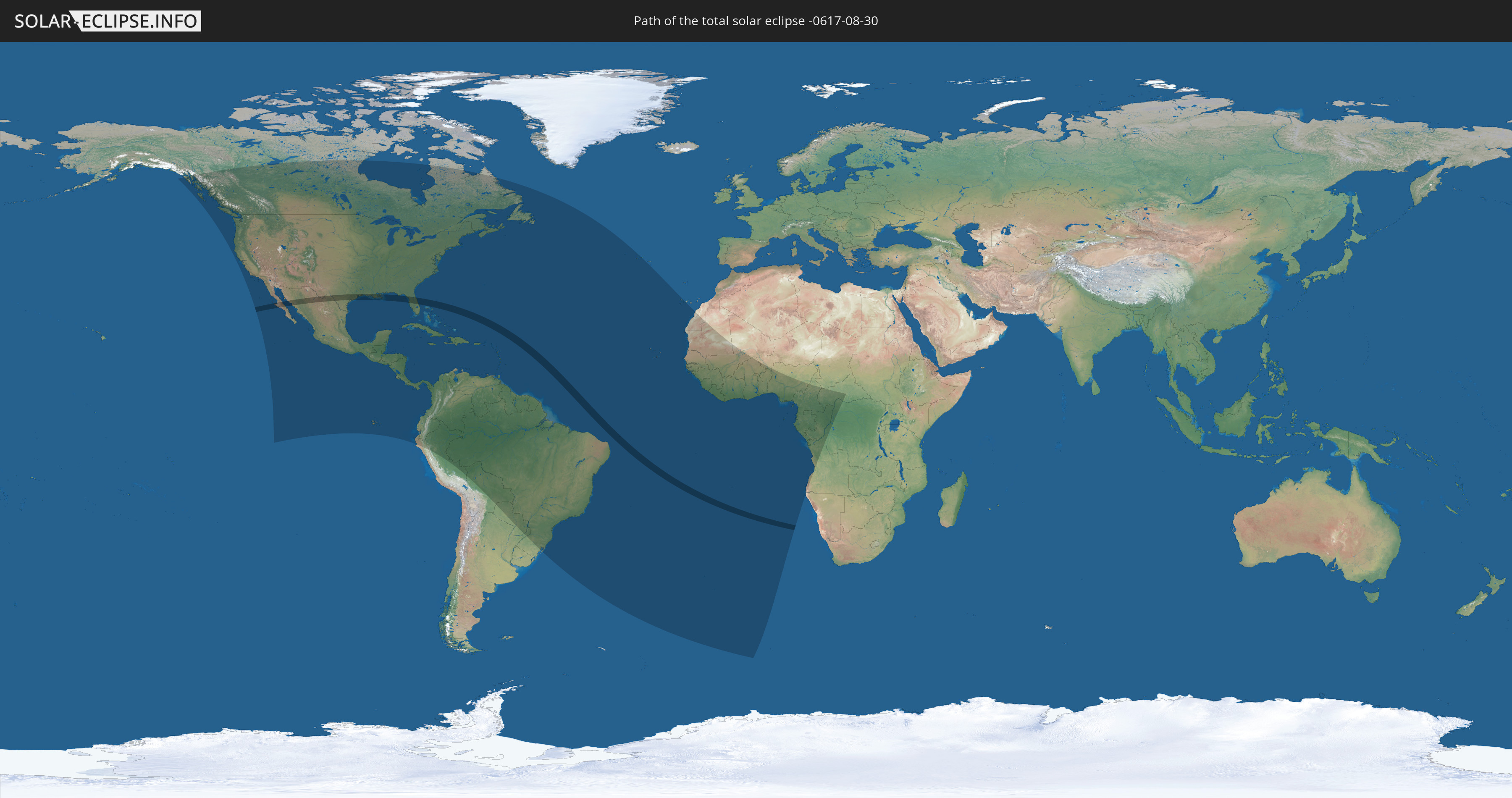
Die Sonnenfinsternis am 08/30/-0617 kann man in 79 Ländern als partielle Sonnenfinsternis beobachten.
Der Finsternispfad verläuft durch 3 Länder. Nur in diesen Ländern ist sie als total Sonnenfinsternis zu sehen.
In den folgenden Ländern ist die Sonnenfinsternis total zu sehen
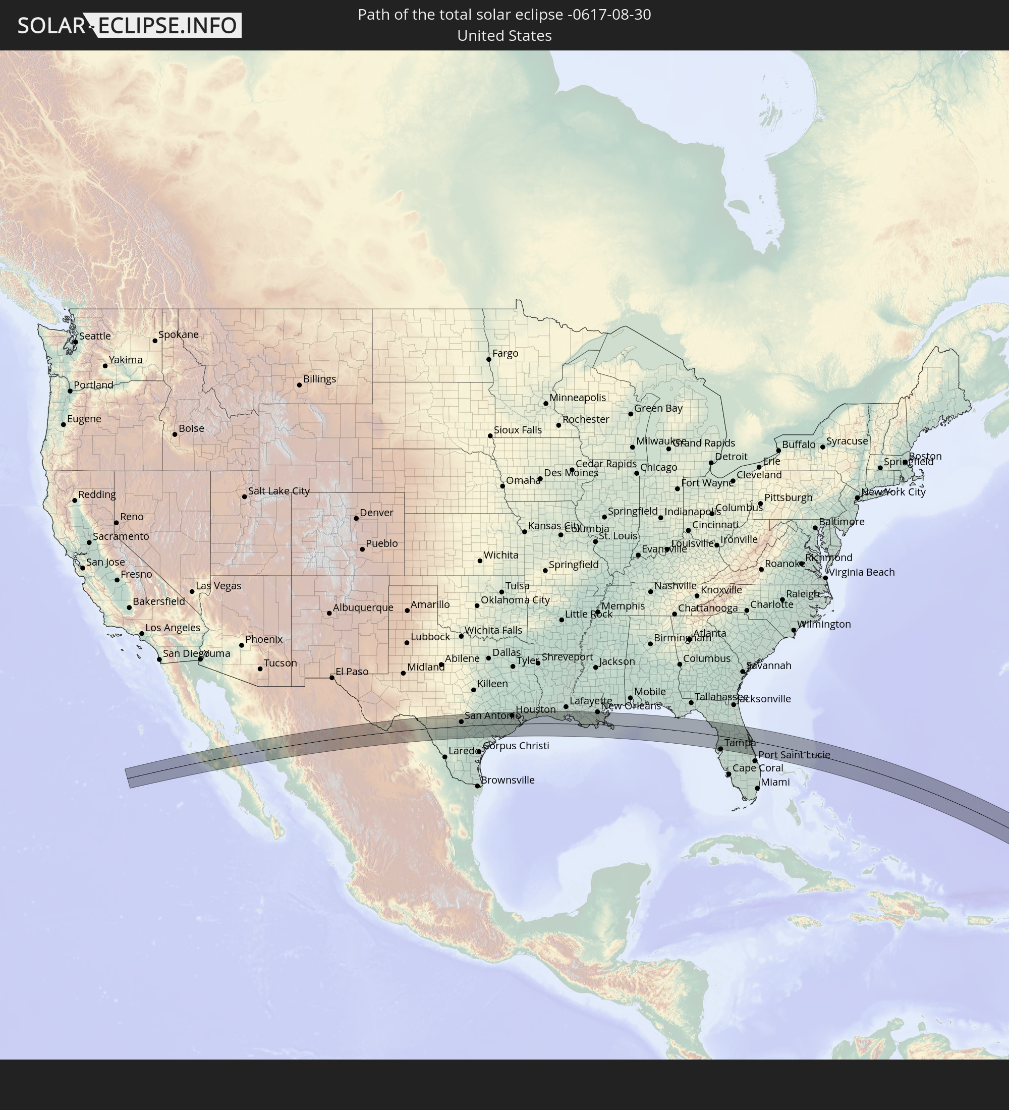 United States
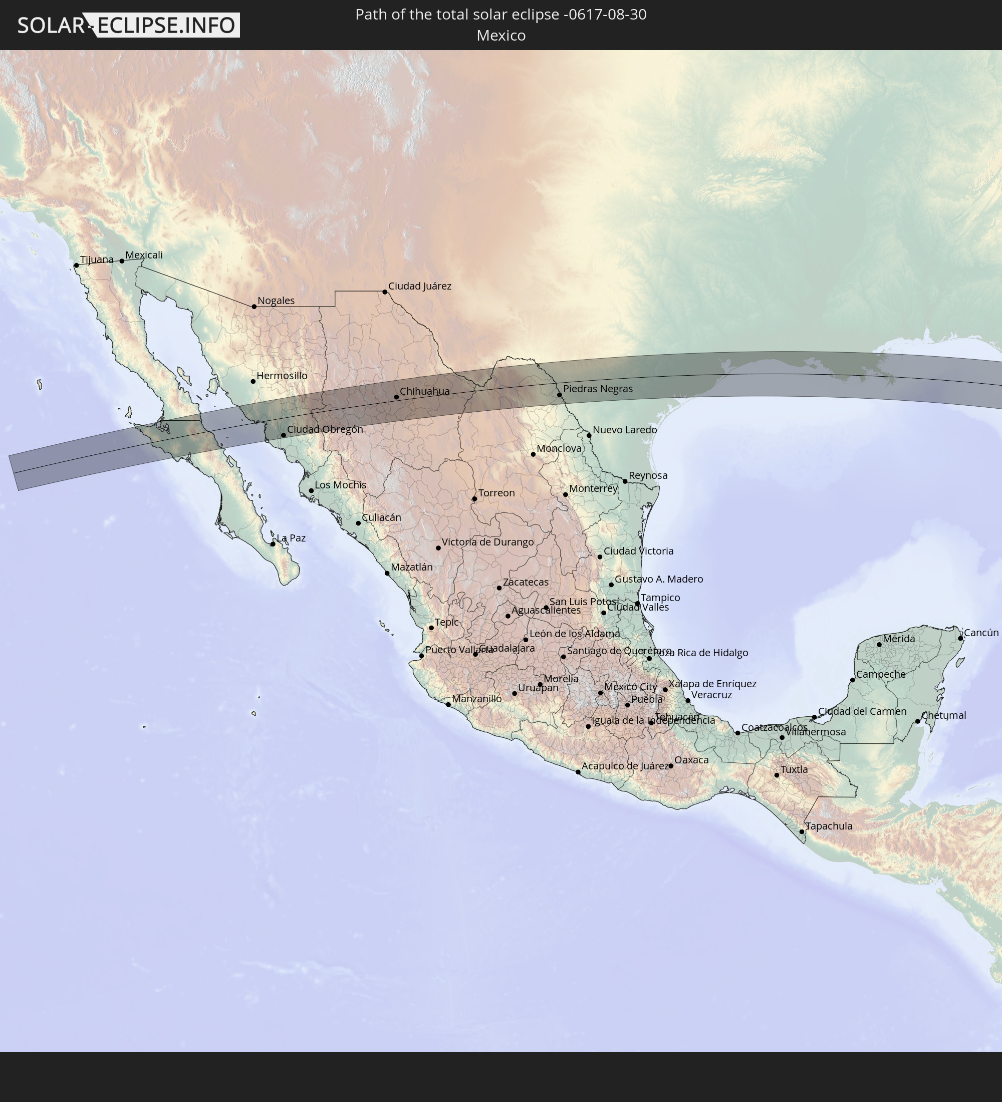 Mexico
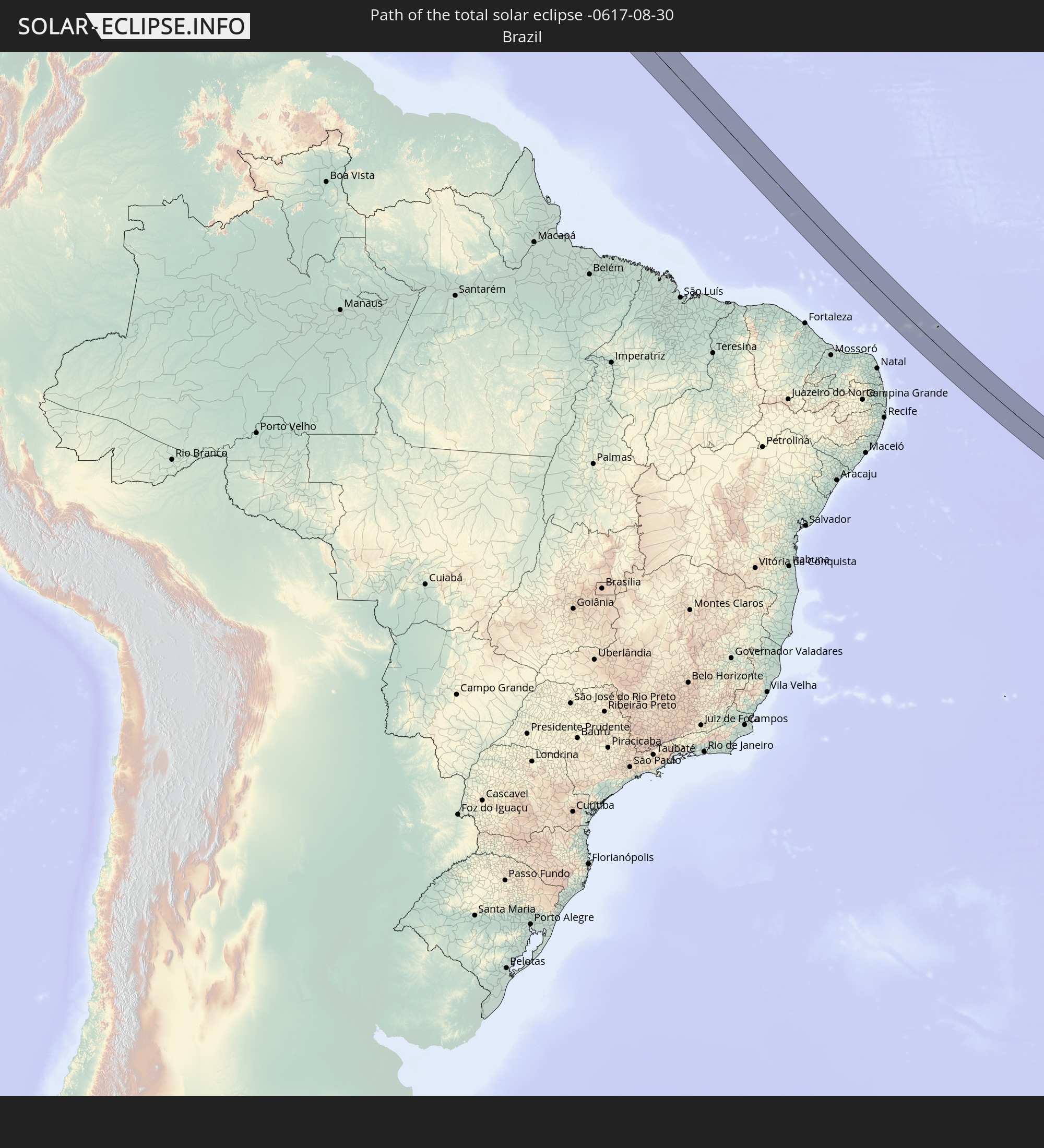 Brazil
In den folgenden Ländern ist die Sonnenfinsternis partiell zu sehen
 United States
 United States Minor Outlying Islands
 Canada
 Mexico
 Greenland
 Guatemala
 Ecuador
 El Salvador
 Honduras
 Belize
 Nicaragua
 Costa Rica
 Cuba
Cuba
 Panama
 Colombia
 Cayman Islands
 Peru
Peru
 The Bahamas
 Jamaica
 Haiti
Haiti
 Brazil
 Argentina
 Venezuela
 Turks and Caicos Islands
 Dominican Republic
 Aruba
Aruba
 Bolivia
 Puerto Rico
 United States Virgin Islands
 Bermuda
 British Virgin Islands
 Anguilla
 Collectivity of Saint Martin
 Saint Barthélemy
 Saint Kitts and Nevis
 Paraguay
 Antigua and Barbuda
 Montserrat
 Trinidad and Tobago
 Guadeloupe
 Grenada
 Dominica
 Saint Vincent and the Grenadines
 Guyana
 Martinique
 Saint Lucia
 Barbados
 Suriname
 Saint Pierre and Miquelon
 French Guiana
 Portugal
 Cabo Verde
 Spain
Spain
 Senegal
 Mauritania
 The Gambia
 Guinea-Bissau
 Guinea
 Saint Helena, Ascension and Tristan da Cunha
 Sierra Leone
 Mali
Mali
 Liberia
 Ivory Coast
 Burkina Faso
 Ghana
Ghana
 Togo
Togo
 Niger
Niger
 Benin
Benin
 Nigeria
 Equatorial Guinea
 São Tomé and Príncipe
 Cameroon
 Gabon
Gabon
 Republic of the Congo
 Angola
 Namibia
 Democratic Republic of the Congo
 Chad
Chad
 Central African Republic
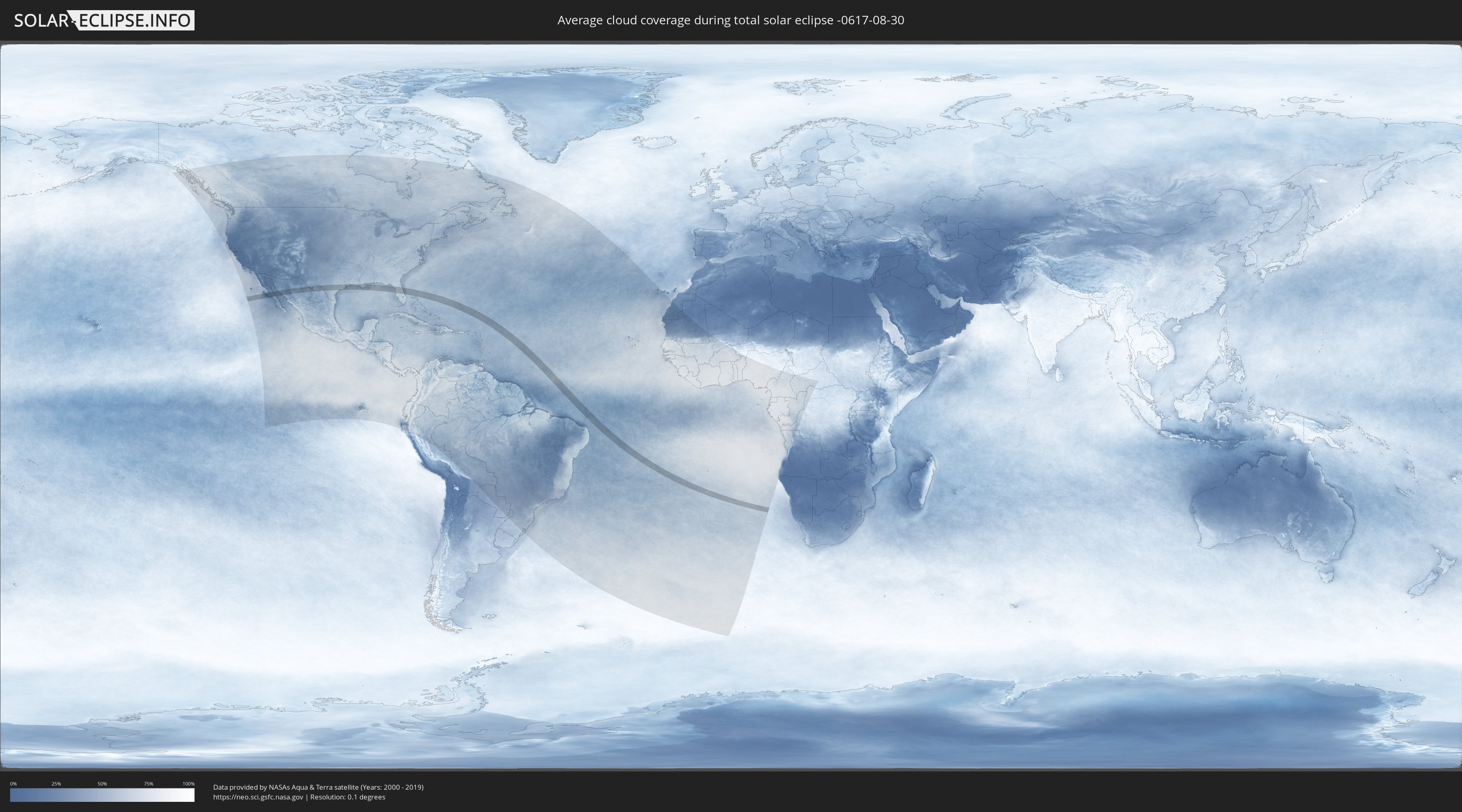
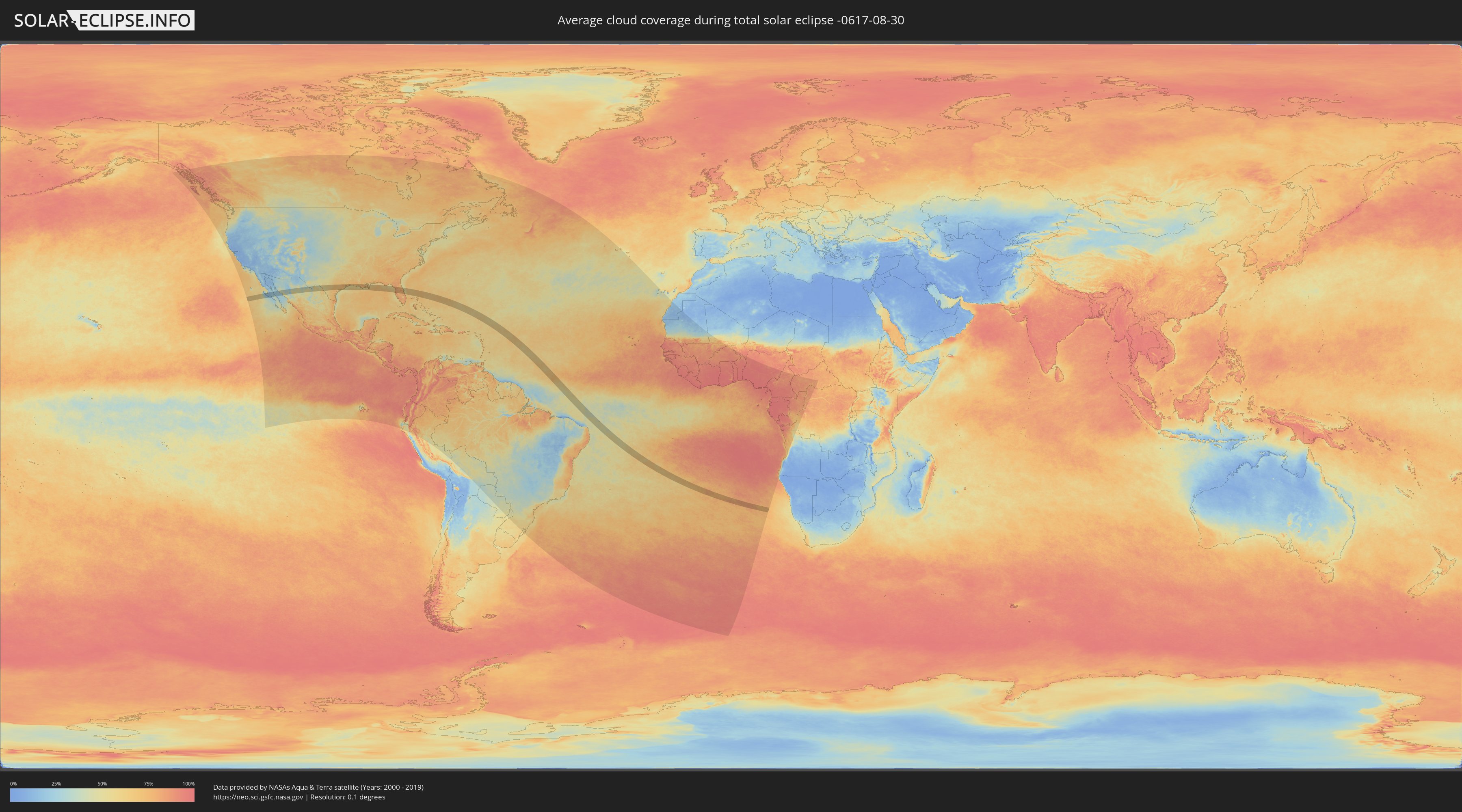
How will be the weather during the total solar eclipse on 08/30/-0617?
Where is the best place to see the total solar eclipse of 08/30/-0617?
The following maps show the average cloud coverage for the day of the total solar eclipse.
With the help of these maps, it is possible to find the place along the eclipse path, which has the best
chance of a cloudless sky.
Nevertheless, you should consider local circumstances and inform about the weather of your chosen
observation site.
The data is provided by NASAs satellites
AQUA and TERRA.
The cloud maps are averaged over a period of 19 years (2000 - 2019).
Detailed country maps
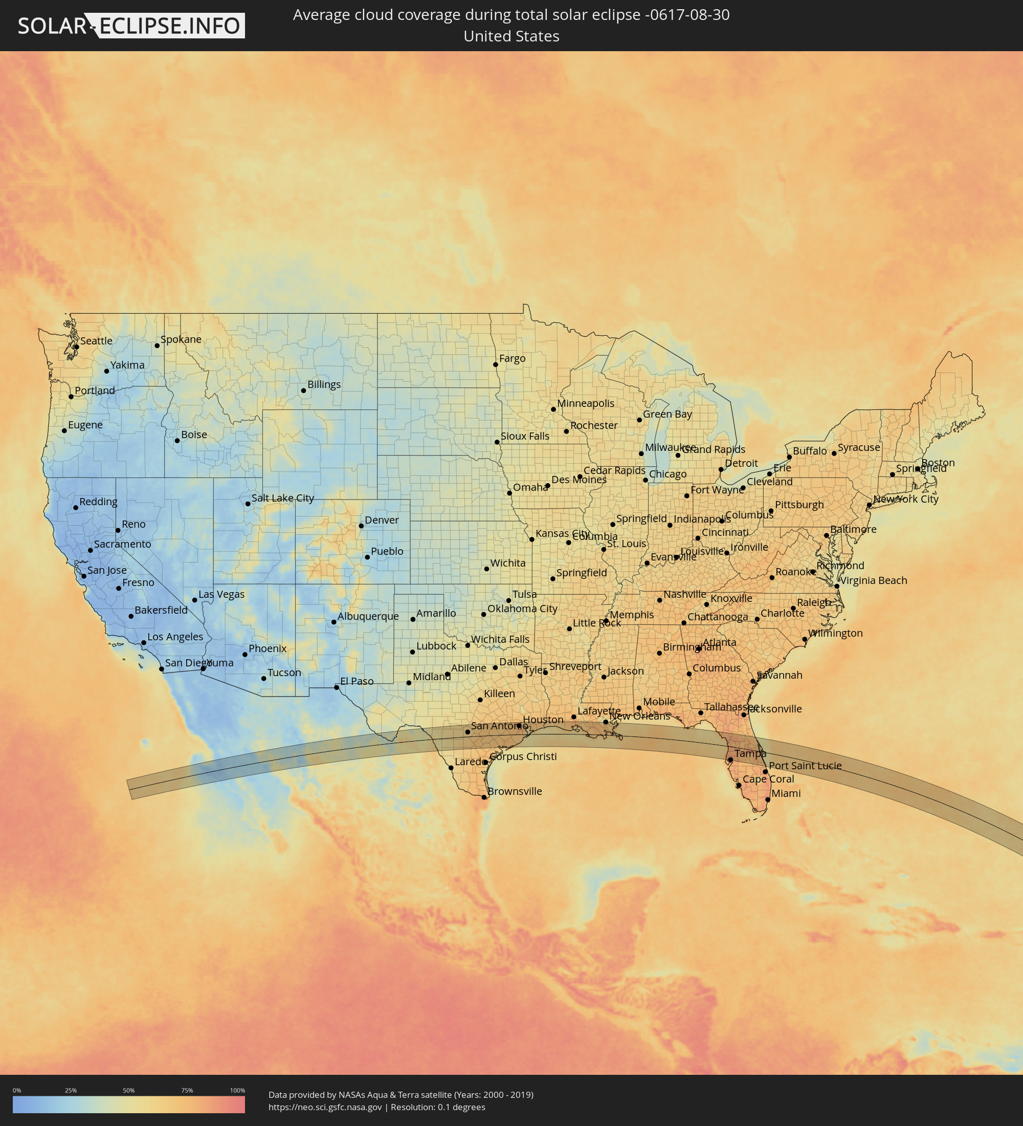 United States
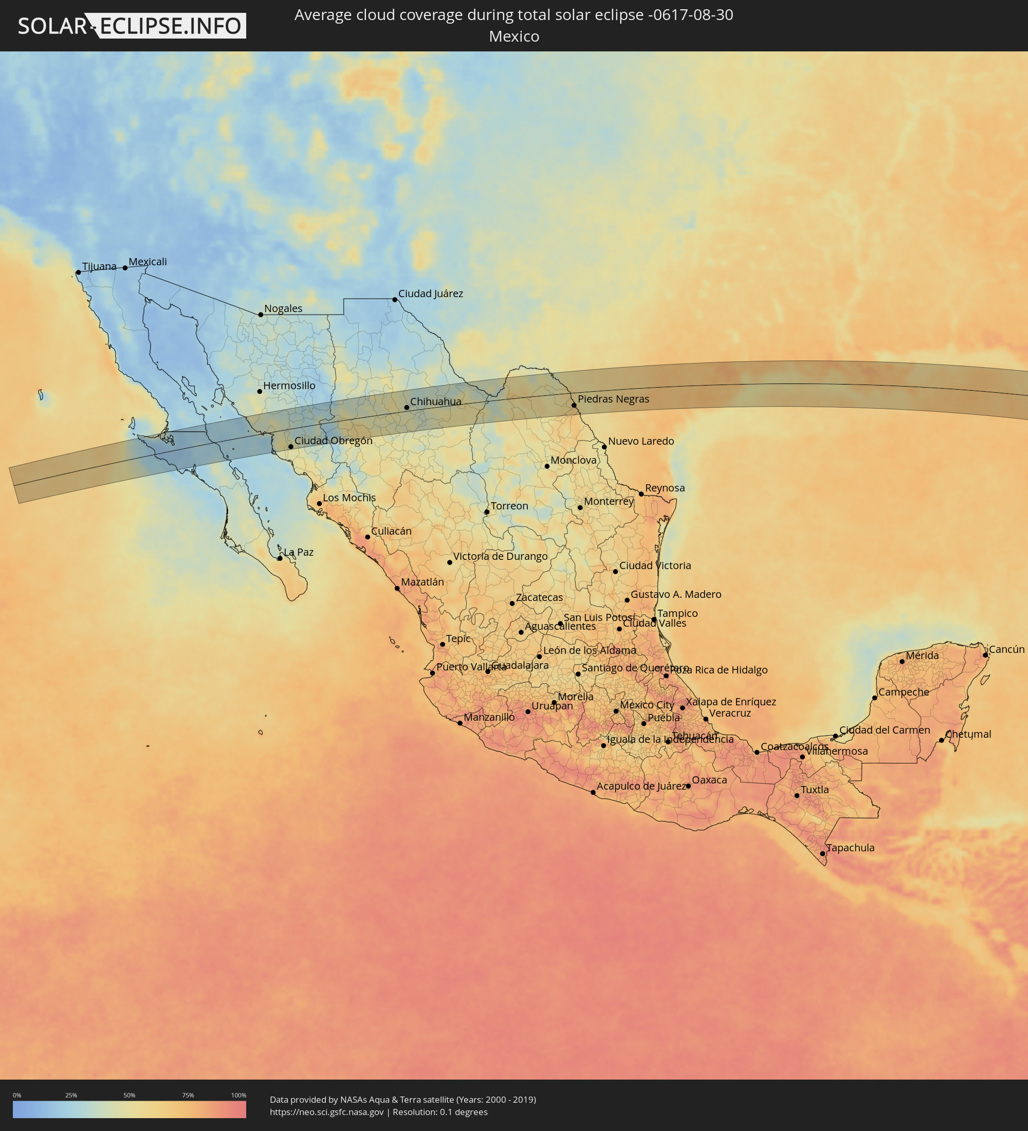 Mexico
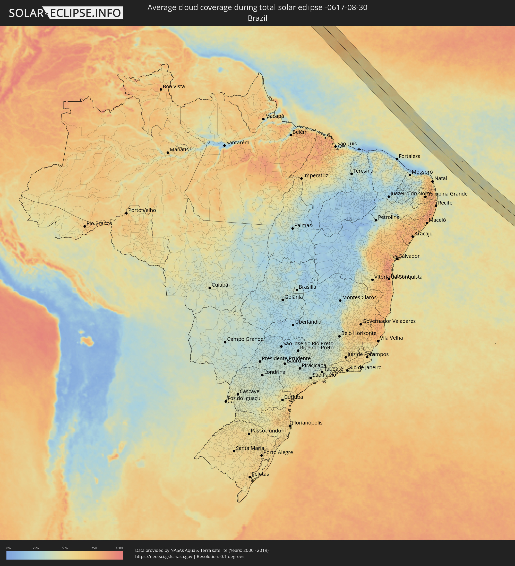 Brazil
Cities inside the path of the eclipse
The following table shows all locations with a population of more than 5,000 inside the eclipse path. Cities which have more than 100,000 inhabitants are marked bold. A click at the locations opens a detailed map.
| City | Type | Eclipse duration | Local time of max. eclipse | Distance to central line | Ø Cloud coverage |
|
Villa Alberto Andrés Alvarado Arámburo, Baja California Sur
|
total | - | 06:28:54 UTC-07:05 | 19 km | 20% |
|
Santa Rosalia, Baja California Sur
|
total | - | 06:29:00 UTC-07:05 | 36 km | 27% |
|
Heroica Guaymas, Sonora
|
total | - | 06:11:09 UTC-07:23 | 4 km | 29% |
|
Empalme, Sonora
|
total | - | 06:11:11 UTC-07:23 | 7 km | 37% |
|
Potam, Sonora
|
total | - | 06:11:12 UTC-07:23 | 37 km | 50% |
|
Vicam, Sonora
|
total | - | 06:11:14 UTC-07:23 | 37 km | 52% |
|
San Ignacio Río Muerto, Sonora
|
total | - | 06:11:12 UTC-07:23 | 62 km | 47% |
|
Campo Sesenta, Sonora
|
total | - | 06:11:15 UTC-07:23 | 61 km | 46% |
|
Cocorit, Sonora
|
total | - | 06:11:18 UTC-07:23 | 50 km | 47% |
|
Ciudad Obregón, Sonora
|
total | - | 06:11:17 UTC-07:23 | 60 km | 45% |
|
Creel, Chihuahua
|
total | - | 06:30:09 UTC-07:05 | 67 km | 56% |
|
Adolfo López Mateos, Chihuahua
|
total | - | 06:30:23 UTC-07:05 | 7 km | 43% |
|
Cuauhtémoc, Chihuahua
|
total | - | 06:30:31 UTC-07:05 | 5 km | 48% |
|
Anáhuac, Chihuahua
|
total | - | 06:30:34 UTC-07:05 | 2 km | 47% |
|
Valentín Gómez Farías, Chihuahua
|
total | - | 06:30:34 UTC-07:05 | 30 km | 44% |
|
Chihuahua, Chihuahua
|
total | - | 06:30:49 UTC-07:05 | 9 km | 45% |
|
Ampliación Colonia Lázaro Cárdenas, Chihuahua
|
total | - | 06:30:57 UTC-07:05 | 24 km | 36% |
|
Rosales, Chihuahua
|
total | - | 06:30:56 UTC-07:05 | 47 km | 38% |
|
Pedro Meoqui, Chihuahua
|
total | - | 06:30:59 UTC-07:05 | 37 km | 39% |
|
Ciudad Delicias, Chihuahua
|
total | - | 06:30:58 UTC-07:05 | 48 km | 40% |
|
Jiménez, Chihuahua
|
total | - | 06:31:01 UTC-07:05 | 33 km | 41% |
|
Saucillo, Chihuahua
|
total | - | 06:31:01 UTC-07:05 | 67 km | 42% |
|
Ciudad Acuña, Coahuila
|
total | - | 07:02:15 UTC-06:36 | 30 km | 50% |
|
Zaragoza, Coahuila
|
total | - | 07:02:09 UTC-06:36 | 62 km | 60% |
|
Del Rio, Texas
|
total | - | 07:38:53 UTC-06:00 | 34 km | 51% |
|
Piedras Negras, Coahuila
|
total | - | 07:02:24 UTC-06:36 | 42 km | 61% |
|
Eagle Pass, Texas
|
total | - | 07:39:00 UTC-06:00 | 42 km | 61% |
|
Eidson Road, Texas
|
total | - | 07:39:01 UTC-06:00 | 45 km | 61% |
|
Uvalde, Texas
|
total | - | 07:39:28 UTC-06:00 | 9 km | 55% |
|
Hondo, Texas
|
total | - | 07:39:51 UTC-06:00 | 19 km | 58% |
|
Pearsall, Texas
|
total | - | 07:39:50 UTC-06:00 | 31 km | 65% |
|
Boerne, Texas
|
total | - | 07:40:09 UTC-06:00 | 67 km | 60% |
|
Lackland Air Force Base, Texas
|
total | - | 07:40:10 UTC-06:00 | 20 km | 62% |
|
San Antonio, Texas
|
total | - | 07:40:15 UTC-06:00 | 24 km | 60% |
|
Pleasanton, Texas
|
total | - | 07:40:13 UTC-06:00 | 27 km | 66% |
|
Timberwood Park, Texas
|
total | - | 07:40:18 UTC-06:00 | 55 km | 61% |
|
Schertz, Texas
|
total | - | 07:40:24 UTC-06:00 | 37 km | 62% |
|
New Braunfels, Texas
|
total | - | 07:40:31 UTC-06:00 | 53 km | 65% |
|
Seguin, Texas
|
total | - | 07:40:36 UTC-06:00 | 37 km | 67% |
|
Lockhart, Texas
|
total | - | 07:40:49 UTC-06:00 | 71 km | 70% |
|
Victoria, Texas
|
total | - | 07:41:09 UTC-06:00 | 52 km | 69% |
|
El Campo, Texas
|
total | - | 07:41:41 UTC-06:00 | 12 km | 74% |
|
Wharton, Texas
|
total | - | 07:41:49 UTC-06:00 | 1 km | 72% |
|
Bay City, Texas
|
total | - | 07:41:53 UTC-06:00 | 37 km | 75% |
|
Rosenberg, Texas
|
total | - | 07:42:02 UTC-06:00 | 27 km | 74% |
|
Cinco Ranch, Texas
|
total | - | 07:42:05 UTC-06:00 | 47 km | 74% |
|
Cypress, Texas
|
total | - | 07:42:09 UTC-06:00 | 72 km | 76% |
|
Sugar Land, Texas
|
total | - | 07:42:10 UTC-06:00 | 33 km | 72% |
|
Fresno, Texas
|
total | - | 07:42:18 UTC-06:00 | 24 km | 70% |
|
Lake Jackson, Texas
|
total | - | 07:42:17 UTC-06:00 | 32 km | 69% |
|
Angleton, Texas
|
total | - | 07:42:17 UTC-06:00 | 17 km | 71% |
|
Aldine, Texas
|
total | - | 07:42:22 UTC-06:00 | 67 km | 75% |
|
Houston, Texas
|
total | - | 07:42:22 UTC-06:00 | 49 km | 79% |
|
Pearland, Texas
|
total | - | 07:42:25 UTC-06:00 | 26 km | 74% |
|
Alvin, Texas
|
total | - | 07:42:26 UTC-06:00 | 11 km | 70% |
|
Pasadena, Texas
|
total | - | 07:42:29 UTC-06:00 | 40 km | 77% |
|
League City, Texas
|
total | - | 07:42:33 UTC-06:00 | 19 km | 71% |
|
Bacliff, Texas
|
total | - | 07:42:38 UTC-06:00 | 19 km | 64% |
|
Baytown, Texas
|
total | - | 07:42:39 UTC-06:00 | 45 km | 66% |
|
La Marque, Texas
|
total | - | 07:42:38 UTC-06:00 | 4 km | 66% |
|
Galveston, Texas
|
total | - | 07:42:46 UTC-06:00 | 4 km | 52% |
|
Port Arthur, Texas
|
total | - | 07:43:27 UTC-06:00 | 60 km | 66% |
|
Abbeville, Louisiana
|
total | - | 07:44:54 UTC-06:00 | 70 km | 75% |
|
New Iberia, Louisiana
|
total | - | 07:45:10 UTC-06:00 | 74 km | 78% |
|
Morgan City, Louisiana
|
total | - | 07:45:42 UTC-06:00 | 41 km | 69% |
|
Thibodaux, Louisiana
|
total | - | 07:46:02 UTC-06:00 | 53 km | 80% |
|
Houma, Louisiana
|
total | - | 07:46:08 UTC-06:00 | 31 km | 77% |
|
Raceland, Louisiana
|
total | - | 07:46:14 UTC-06:00 | 46 km | 75% |
|
Luling, Louisiana
|
total | - | 07:46:27 UTC-06:00 | 70 km | 73% |
|
Harahan, Louisiana
|
total | - | 07:46:36 UTC-06:00 | 71 km | 69% |
|
Westwego, Louisiana
|
total | - | 07:46:39 UTC-06:00 | 68 km | 75% |
|
New Orleans, Louisiana
|
total | - | 07:46:43 UTC-06:00 | 73 km | 75% |
|
Palm Harbor, Florida
|
total | - | 08:54:53 UTC-05:00 | 70 km | 75% |
|
Bayonet Point, Florida
|
total | - | 08:54:55 UTC-05:00 | 41 km | 79% |
|
Keystone, Florida
|
total | - | 08:55:02 UTC-05:00 | 59 km | 80% |
|
Town 'n' Country, Florida
|
total | - | 08:55:08 UTC-05:00 | 75 km | 75% |
|
Homosassa Springs, Florida
|
total | - | 08:54:55 UTC-05:00 | 13 km | 77% |
|
North Weeki Wachee, Florida
|
total | - | 08:55:00 UTC-05:00 | 15 km | 78% |
|
Spring Hill, Florida
|
total | - | 08:55:04 UTC-05:00 | 22 km | 85% |
|
Pine Ridge, Florida
|
total | - | 08:55:00 UTC-05:00 | 29 km | 82% |
|
Citrus Springs, Florida
|
total | - | 08:54:59 UTC-05:00 | 36 km | 81% |
|
Beverly Hills, Florida
|
total | - | 08:55:01 UTC-05:00 | 27 km | 82% |
|
University, Florida
|
total | - | 08:55:17 UTC-05:00 | 66 km | 83% |
|
Hernando, Florida
|
total | - | 08:55:08 UTC-05:00 | 26 km | 80% |
|
Wesley Chapel, Florida
|
total | - | 08:55:23 UTC-05:00 | 46 km | 80% |
|
Brandon, Florida
|
total | - | 08:55:31 UTC-05:00 | 78 km | 81% |
|
Ocala, Florida
|
total | - | 08:55:20 UTC-05:00 | 61 km | 85% |
|
Plant City, Florida
|
total | - | 08:55:43 UTC-05:00 | 67 km | 81% |
|
Winston, Florida
|
total | - | 08:55:50 UTC-05:00 | 64 km | 80% |
|
Fuller Heights, Florida
|
total | - | 08:55:54 UTC-05:00 | 77 km | 73% |
|
Medulla, Florida
|
total | - | 08:55:55 UTC-05:00 | 70 km | 80% |
|
The Villages, Florida
|
total | - | 08:55:38 UTC-05:00 | 36 km | 77% |
|
Lakeland, Florida
|
total | - | 08:55:55 UTC-05:00 | 62 km | 76% |
|
Leesburg, Florida
|
total | - | 08:55:46 UTC-05:00 | 24 km | 76% |
|
Groveland, Florida
|
total | - | 08:55:53 UTC-05:00 | 3 km | 78% |
|
Bartow, Florida
|
total | - | 08:56:06 UTC-05:00 | 76 km | 75% |
|
Clermont, Florida
|
total | - | 08:55:59 UTC-05:00 | 3 km | 75% |
|
Minneola, Florida
|
total | - | 08:56:01 UTC-05:00 | 0 km | 77% |
|
Winter Haven, Florida
|
total | - | 08:56:12 UTC-05:00 | 60 km | 75% |
|
Cypress Gardens, Florida
|
total | - | 08:56:16 UTC-05:00 | 63 km | 75% |
|
Eustis, Florida
|
total | - | 08:56:00 UTC-05:00 | 32 km | 71% |
|
Four Corners, Florida
|
total | - | 08:56:13 UTC-05:00 | 25 km | 82% |
|
Haines City, Florida
|
total | - | 08:56:19 UTC-05:00 | 49 km | 76% |
|
Lake Wales, Florida
|
total | - | 08:56:26 UTC-05:00 | 71 km | 75% |
|
Lake Butler, Florida
|
total | - | 08:56:17 UTC-05:00 | 5 km | 82% |
|
Apopka, Florida
|
total | - | 08:56:16 UTC-05:00 | 15 km | 83% |
|
Poinciana, Florida
|
total | - | 08:56:31 UTC-05:00 | 43 km | 73% |
|
Kissimmee, Florida
|
total | - | 08:56:31 UTC-05:00 | 24 km | 73% |
|
Orlando, Florida
|
total | - | 08:56:29 UTC-05:00 | 2 km | 86% |
|
Winter Springs, Florida
|
total | - | 08:56:32 UTC-05:00 | 21 km | 84% |
|
Union Park, Florida
|
total | - | 08:56:36 UTC-05:00 | 7 km | 86% |
|
Deltona, Florida
|
total | - | 08:56:31 UTC-05:00 | 44 km | 76% |
|
Alafaya, Florida
|
total | - | 08:56:42 UTC-05:00 | 8 km | 87% |
|
Port Orange, Florida
|
total | - | 08:56:47 UTC-05:00 | 74 km | 75% |
|
Edgewater, Florida
|
total | - | 08:56:57 UTC-05:00 | 59 km | 67% |
|
Titusville, Florida
|
total | - | 08:57:12 UTC-05:00 | 20 km | 76% |
|
Rockledge, Florida
|
total | - | 08:57:24 UTC-05:00 | 8 km | 76% |
|
Merritt Island, Florida
|
total | - | 08:57:24 UTC-05:00 | 14 km | 69% |
|
Cape Canaveral, Florida
|
total | - | 08:57:32 UTC-05:00 | 1 km | 67% |
|
Satellite Beach, Florida
|
total | - | 08:57:38 UTC-05:00 | 25 km | 69% |
|
Palm Bay, Florida
|
total | - | 08:57:41 UTC-05:00 | 40 km | 77% |
|
Micco, Florida
|
total | - | 08:57:52 UTC-05:00 | 55 km | 71% |
|
Sebastian, Florida
|
total | - | 08:57:55 UTC-05:00 | 62 km | 79% |
|
Gifford, Florida
|
total | - | 08:58:04 UTC-05:00 | 76 km | 73% |
|
Vero Beach, Florida
|
total | - | 08:58:05 UTC-05:00 | 80 km | 76% |