Total solar eclipse of 05/09/-0992
| Day of week: | Saturday |
| Maximum duration of eclipse: | 04m12s |
| Maximum width of eclipse path: | 429 km |
| Saros cycle: | 51 |
| Coverage: | 100% |
| Magnitude: | 1.0712 |
| Gamma: | 0.8433 |
Wo kann man die Sonnenfinsternis vom 05/09/-0992 sehen?
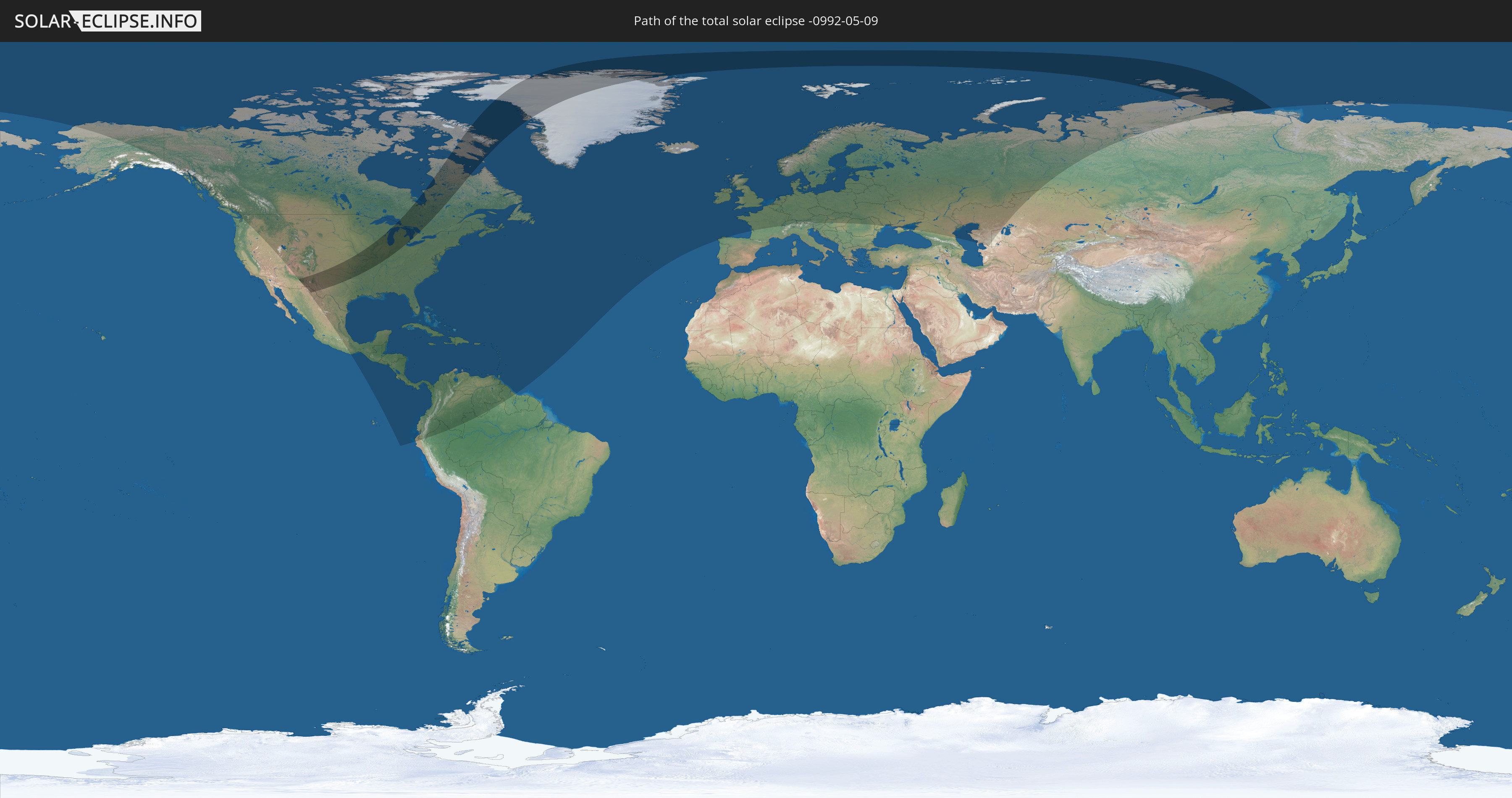
Die Sonnenfinsternis am 05/09/-0992 kann man in 84 Ländern als partielle Sonnenfinsternis beobachten.
Der Finsternispfad verläuft durch 5 Länder. Nur in diesen Ländern ist sie als total Sonnenfinsternis zu sehen.
In den folgenden Ländern ist die Sonnenfinsternis total zu sehen
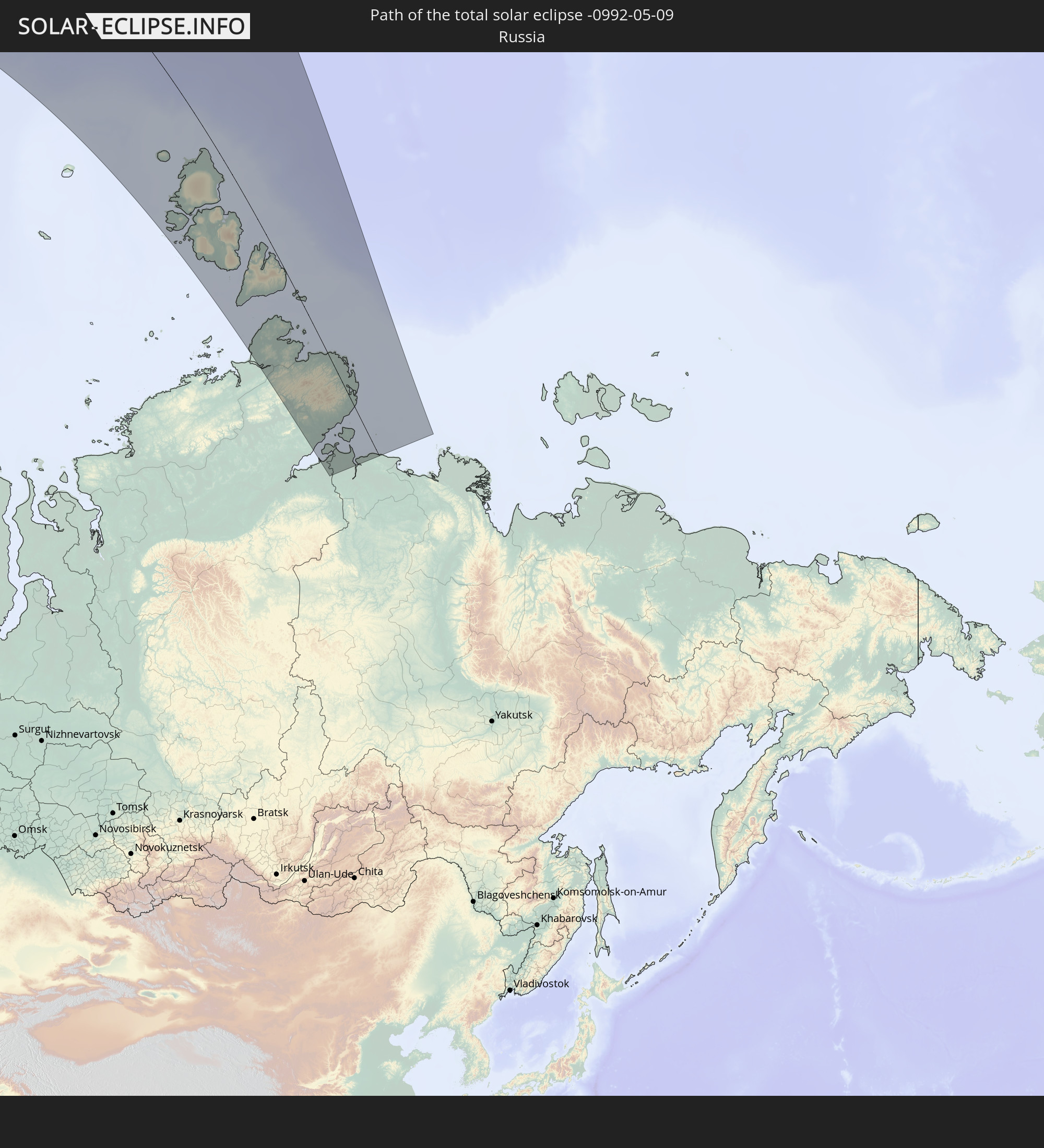 Russia
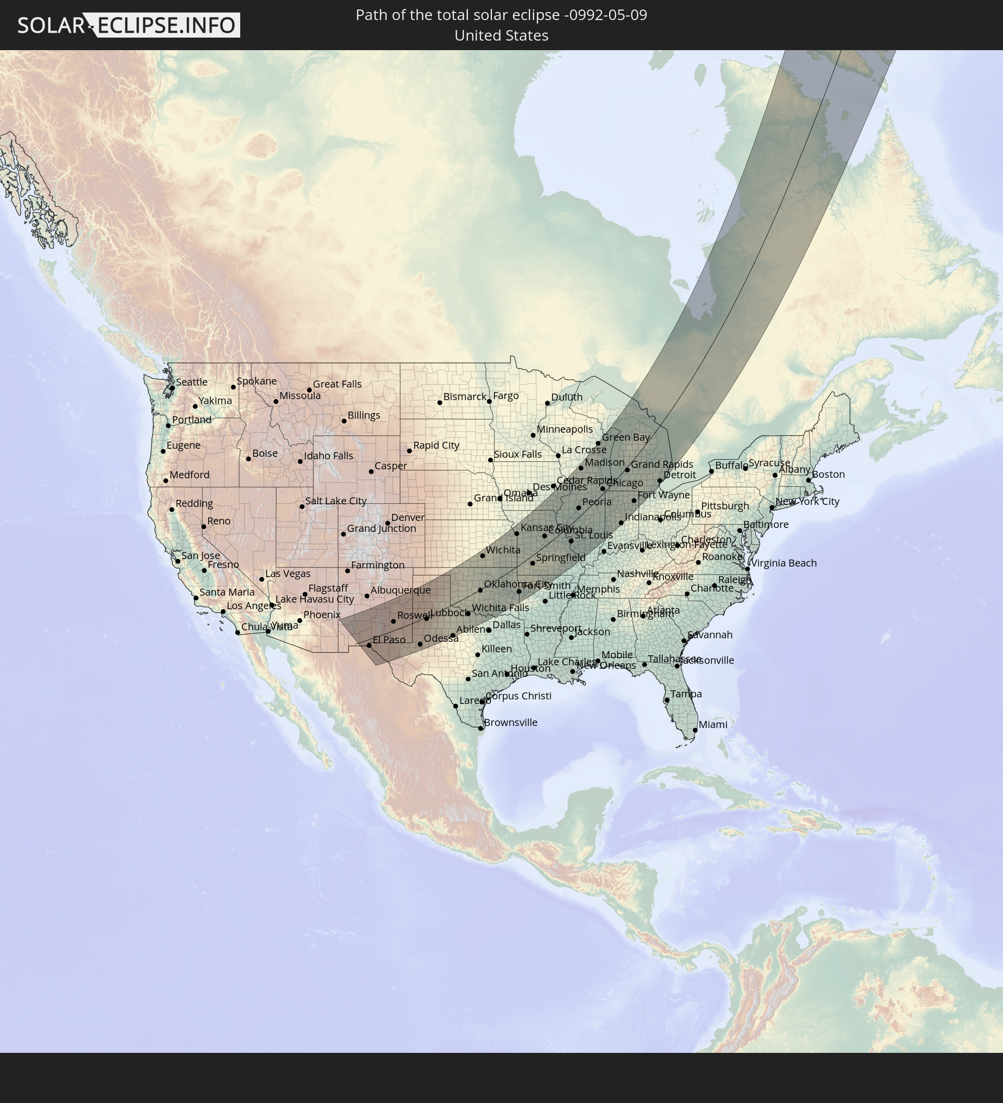 United States
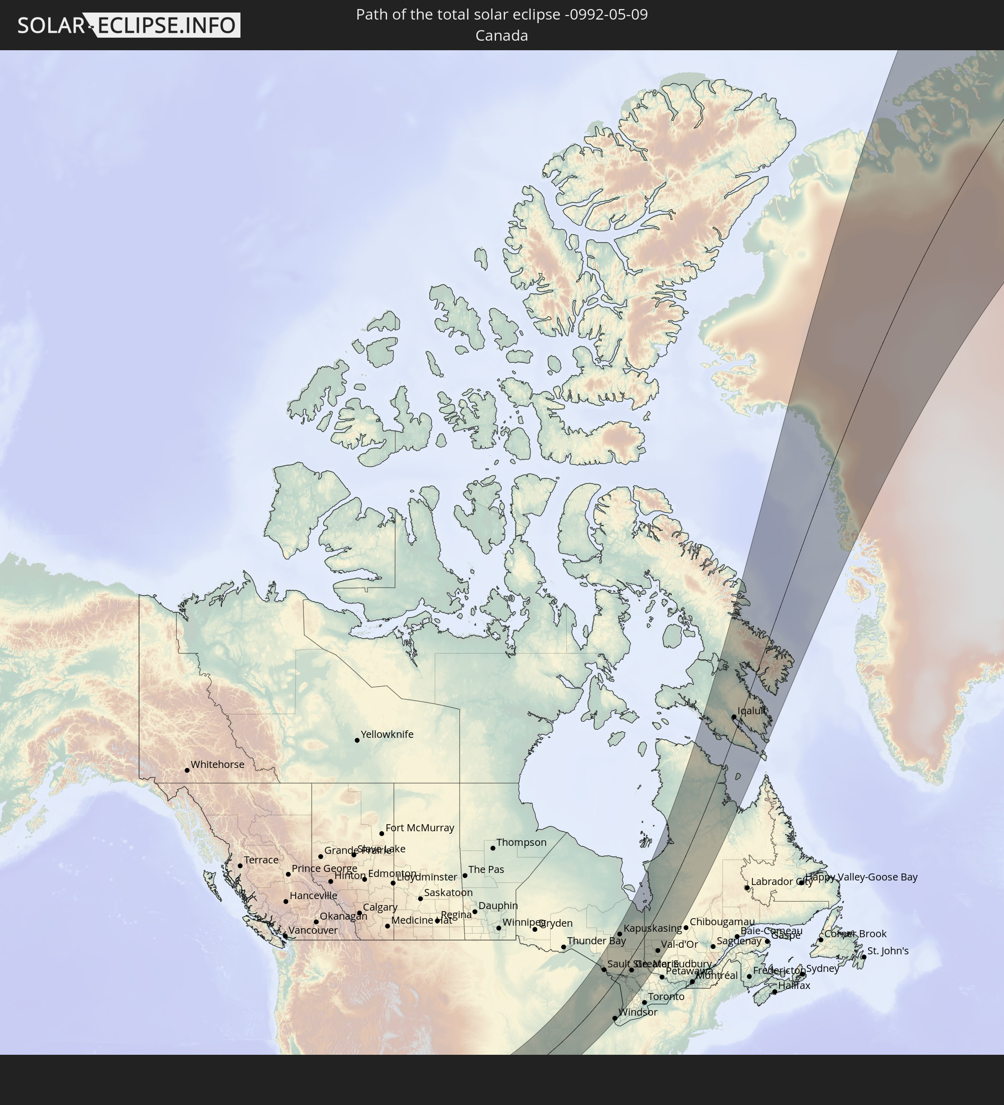 Canada
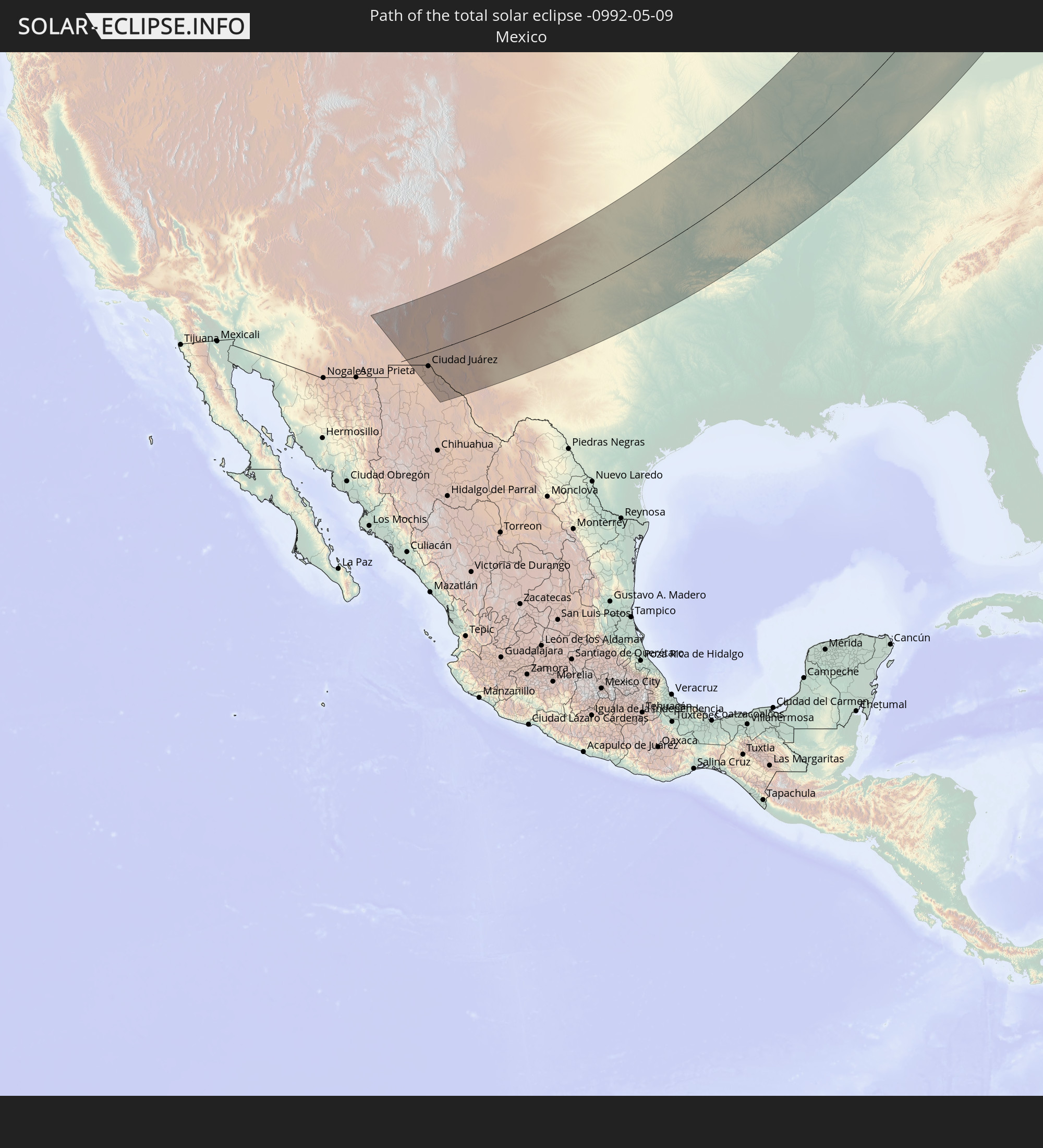 Mexico
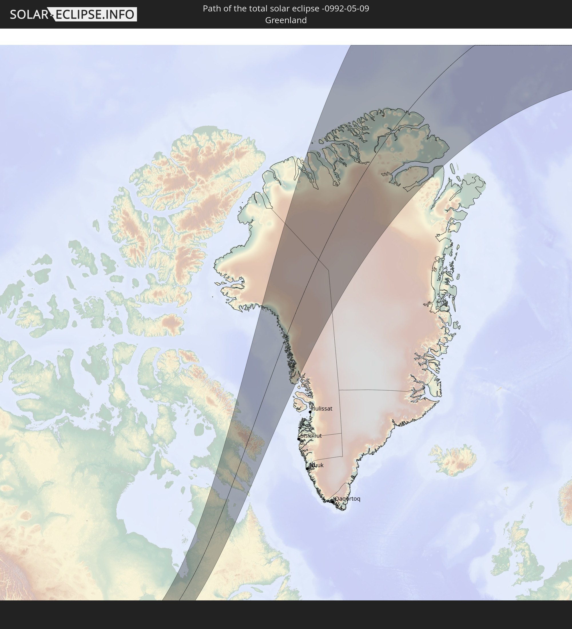 Greenland
In den folgenden Ländern ist die Sonnenfinsternis partiell zu sehen
 Russia
 United States
 United States Minor Outlying Islands
 Canada
 Mexico
 Greenland
 Guatemala
 Ecuador
 El Salvador
 Honduras
 Belize
 Nicaragua
 Costa Rica
 Cuba
Cuba
 Panama
 Colombia
 Cayman Islands
 Peru
Peru
 The Bahamas
 Jamaica
 Haiti
Haiti
 Brazil
 Venezuela
 Turks and Caicos Islands
 Dominican Republic
 Aruba
Aruba
 Puerto Rico
 United States Virgin Islands
 Bermuda
 British Virgin Islands
 Anguilla
 Collectivity of Saint Martin
 Saint Barthélemy
 Saint Kitts and Nevis
 Antigua and Barbuda
 Montserrat
 Trinidad and Tobago
 Guadeloupe
 Grenada
 Dominica
 Saint Vincent and the Grenadines
 Guyana
 Martinique
 Saint Lucia
 Barbados
 Saint Pierre and Miquelon
 Portugal
 Iceland
 Spain
Spain
 Republic of Ireland
 Svalbard and Jan Mayen
 United Kingdom
 Faroe Islands
 France
 Isle of Man
 Guernsey
 Jersey
 Belgium
 Netherlands
 Norway
 Luxembourg
 Germany
 Switzerland
 Italy
Italy
 Denmark
 Liechtenstein
 Austria
 Sweden
 Czechia
 Poland
 Hungary
 Slovakia
 Åland Islands
 Romania
 Finland
 Lithuania
 Latvia
 Estonia
 Ukraine
 Belarus
 Moldova
 Kazakhstan
 Turkmenistan
 Uzbekistan
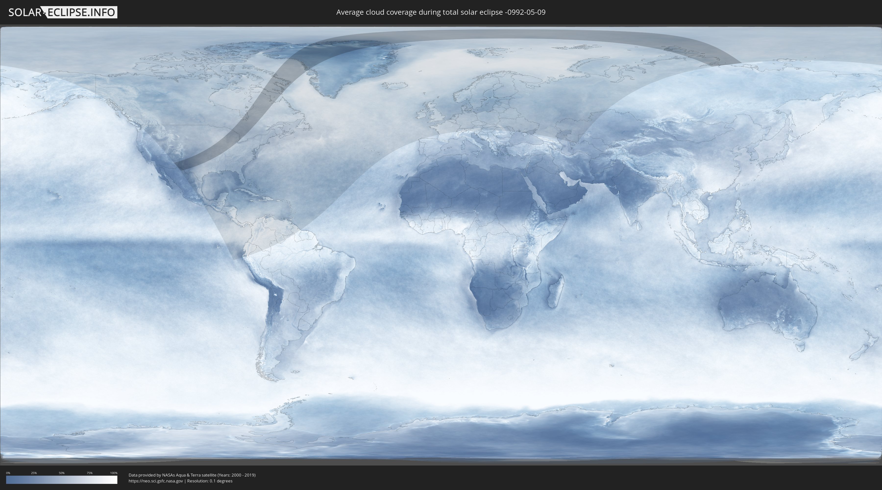
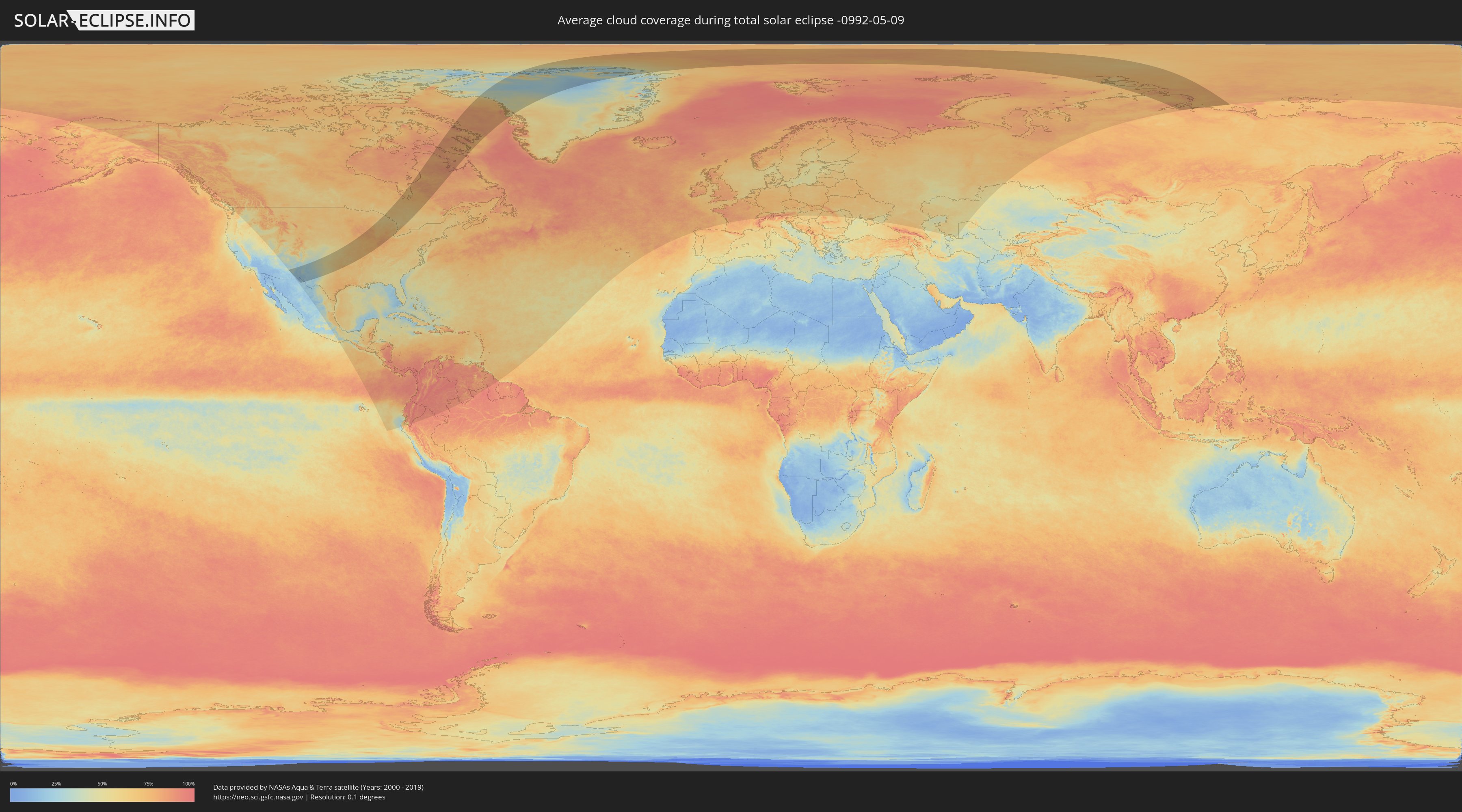
How will be the weather during the total solar eclipse on 05/09/-0992?
Where is the best place to see the total solar eclipse of 05/09/-0992?
The following maps show the average cloud coverage for the day of the total solar eclipse.
With the help of these maps, it is possible to find the place along the eclipse path, which has the best
chance of a cloudless sky.
Nevertheless, you should consider local circumstances and inform about the weather of your chosen
observation site.
The data is provided by NASAs satellites
AQUA and TERRA.
The cloud maps are averaged over a period of 19 years (2000 - 2019).
Detailed country maps
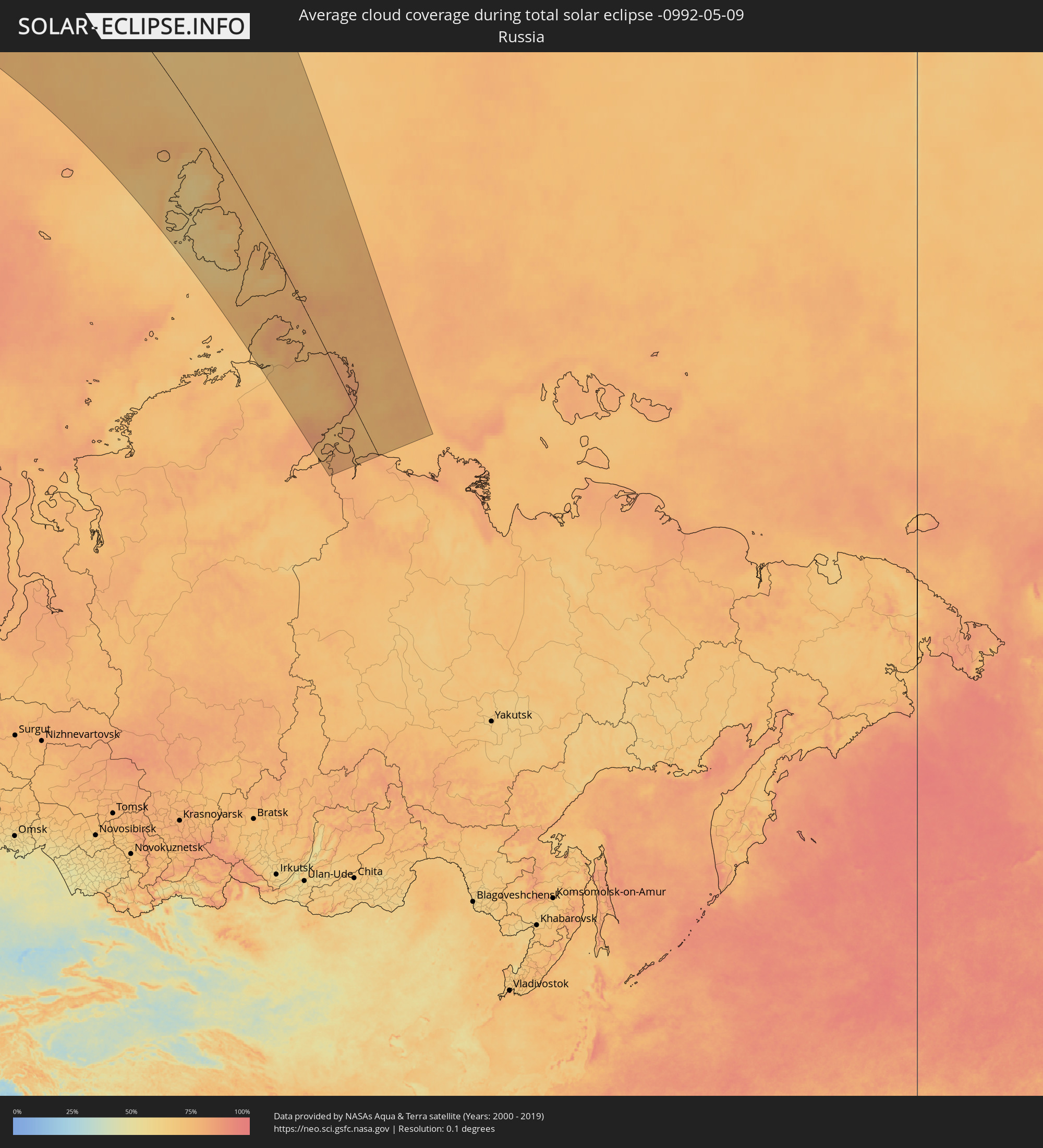 Russia
 United States
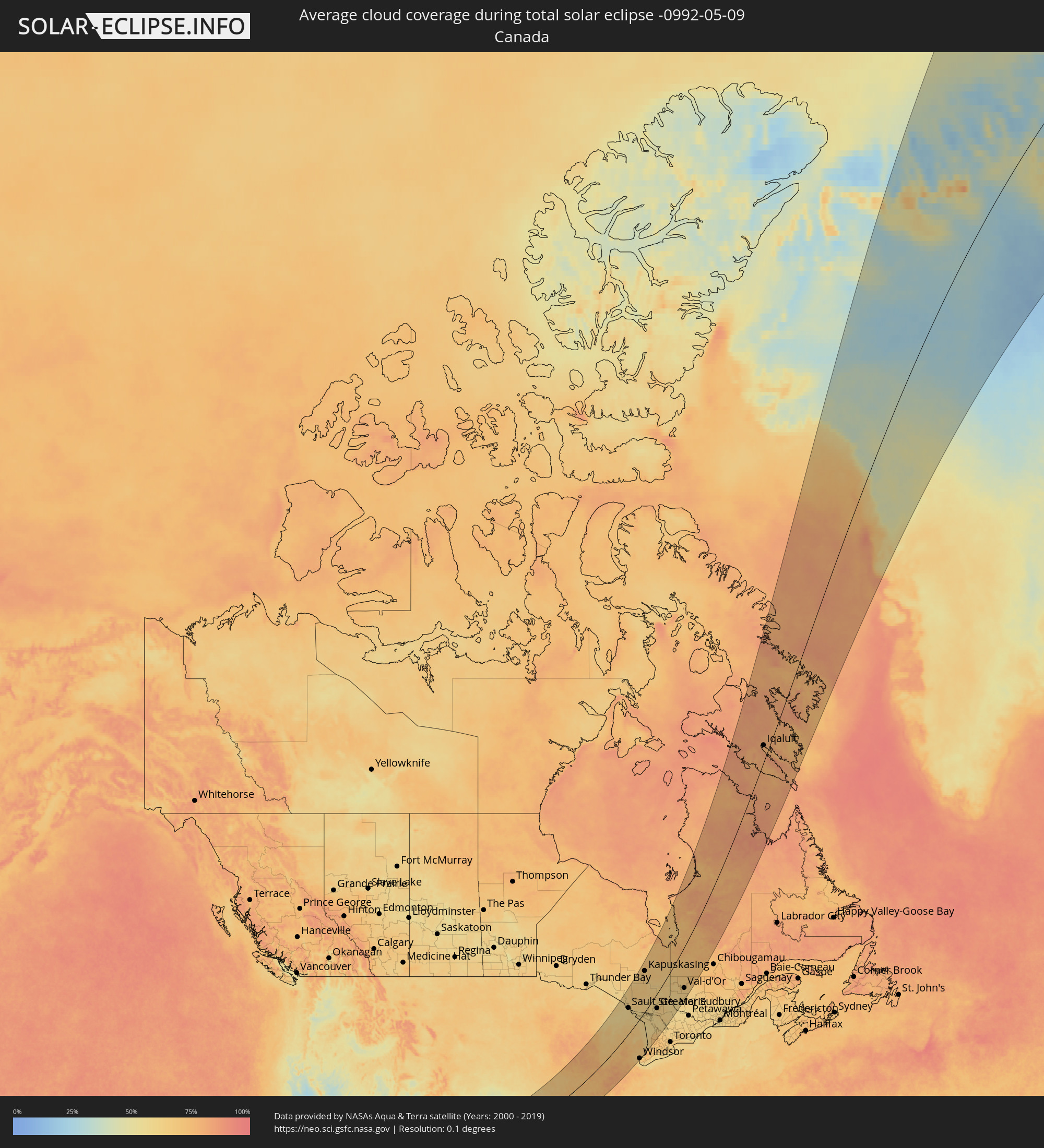 Canada
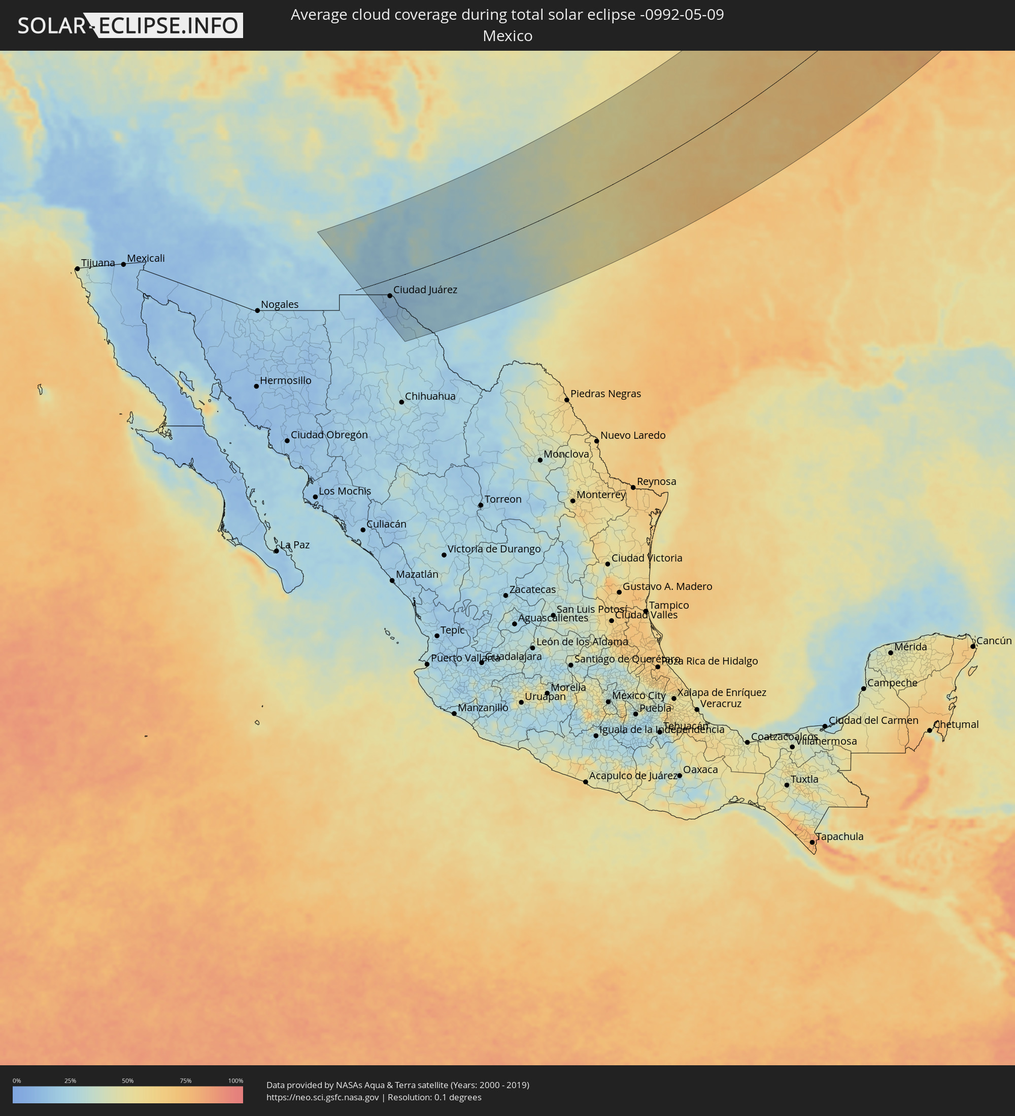 Mexico
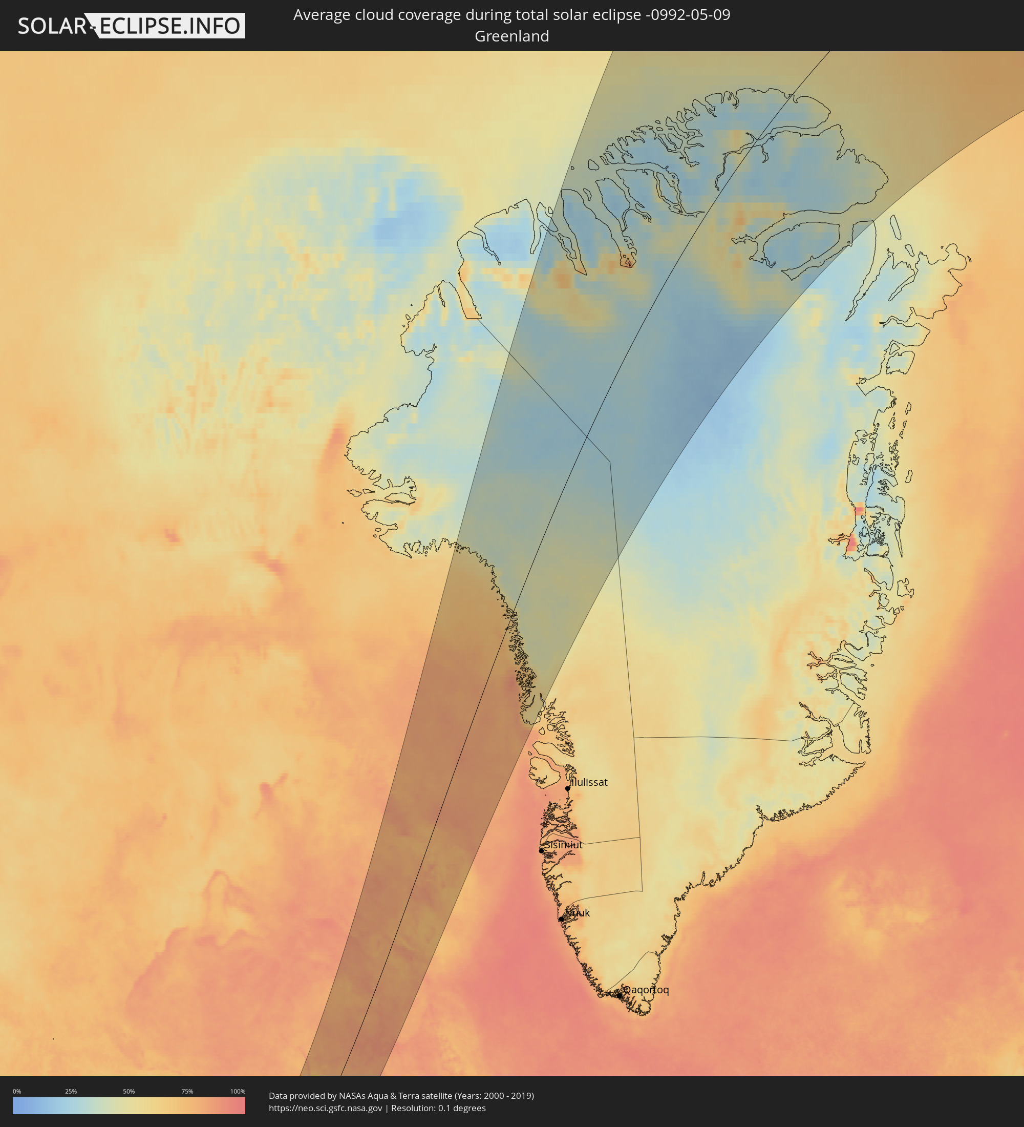 Greenland
Cities inside the path of the eclipse
The following table shows all locations with a population of more than 5,000 inside the eclipse path. Cities which have more than 100,000 inhabitants are marked bold. A click at the locations opens a detailed map.
| City | Type | Eclipse duration | Local time of max. eclipse | Distance to central line | Ø Cloud coverage |
|
Las Cruces, New Mexico
|
total | - | 05:26:40 UTC-07:00 | 28 km | 19% |
|
El Paso, Texas
|
total | - | 05:25:48 UTC-07:00 | 51 km | 18% |
|
Ciudad Juárez, Chihuahua
|
total | - | 05:20:06 UTC-07:05 | 54 km | 17% |
|
Odessa, Texas
|
total | - | 06:24:39 UTC-06:00 | 175 km | 24% |
|
Midland, Texas
|
total | - | 06:24:48 UTC-06:00 | 171 km | 27% |
|
Lubbock, Texas
|
total | - | 06:27:01 UTC-06:00 | 18 km | 35% |
|
Amarillo, Texas
|
total | - | 06:29:27 UTC-06:00 | 150 km | 40% |
|
Abilene, Texas
|
total | - | 06:24:53 UTC-06:00 | 214 km | 53% |
|
Wichita Falls, Texas
|
total | - | 06:26:49 UTC-06:00 | 118 km | 53% |
|
Lawton, Oklahoma
|
total | - | 06:27:51 UTC-06:00 | 56 km | 56% |
|
Oklahoma City, Oklahoma
|
total | - | 06:29:02 UTC-06:00 | 11 km | 58% |
|
Edmond, Oklahoma
|
total | - | 06:29:19 UTC-06:00 | 10 km | 59% |
|
Norman, Oklahoma
|
total | - | 06:28:38 UTC-06:00 | 39 km | 61% |
|
Wichita, Kansas
|
total | - | 06:32:30 UTC-06:00 | 195 km | 57% |
|
Tulsa, Oklahoma
|
total | - | 06:29:55 UTC-06:00 | 14 km | 64% |
|
Broken Arrow, Oklahoma
|
total | - | 06:29:44 UTC-06:00 | 33 km | 65% |
|
Topeka, Kansas
|
total | - | 06:34:32 UTC-06:00 | 237 km | 59% |
|
Lawrence, Kansas
|
total | - | 06:34:23 UTC-06:00 | 207 km | 59% |
|
Olathe, Kansas
|
total | - | 06:34:13 UTC-06:00 | 178 km | 63% |
|
Overland Park, Kansas
|
total | - | 06:34:22 UTC-06:00 | 179 km | 62% |
|
Kansas City, Missouri
|
total | - | 06:34:33 UTC-06:00 | 186 km | 62% |
|
Fort Smith, Arkansas
|
total | - | 06:28:33 UTC-06:00 | 164 km | 65% |
|
Lee's Summit, Missouri
|
total | - | 06:34:14 UTC-06:00 | 159 km | 61% |
|
East Independence, Missouri
|
total | - | 06:34:32 UTC-06:00 | 173 km | 62% |
|
Fayetteville, Arkansas
|
total | - | 06:29:36 UTC-06:00 | 113 km | 64% |
|
Springfield, Missouri
|
total | - | 06:31:25 UTC-06:00 | 53 km | 70% |
|
Columbia, Missouri
|
total | - | 06:34:15 UTC-06:00 | 52 km | 70% |
|
O'Fallon, Missouri
|
total | - | 06:34:02 UTC-06:00 | 51 km | 69% |
|
Davenport, Iowa
|
total | - | 06:38:39 UTC-06:00 | 168 km | 73% |
|
St. Louis, Missouri
|
total | - | 06:33:44 UTC-06:00 | 95 km | 73% |
|
Springfield, Illinois
|
total | - | 06:35:45 UTC-06:00 | 32 km | 73% |
|
Peoria, Illinois
|
total | - | 06:37:17 UTC-06:00 | 51 km | 72% |
|
Madison, Wisconsin
|
total | - | 06:41:26 UTC-06:00 | 217 km | 77% |
|
Rockford, Illinois
|
total | - | 06:40:03 UTC-06:00 | 138 km | 78% |
|
Bloomington, Illinois
|
total | - | 06:36:57 UTC-06:00 | 12 km | 76% |
|
Decatur, Illinois
|
total | - | 06:35:51 UTC-06:00 | 64 km | 73% |
|
Appleton, Wisconsin
|
total | - | 06:43:38 UTC-06:00 | 244 km | 74% |
|
Aurora, Illinois
|
total | - | 06:39:14 UTC-06:00 | 55 km | 76% |
|
Elgin, Illinois
|
total | - | 06:39:43 UTC-06:00 | 74 km | 77% |
|
Champaign, Illinois
|
total | - | 06:36:23 UTC-06:00 | 83 km | 72% |
|
Waukesha, Wisconsin
|
total | - | 06:41:26 UTC-06:00 | 142 km | 77% |
|
Joliet, Illinois
|
total | - | 06:38:51 UTC-06:00 | 22 km | 75% |
|
Bolingbrook, Illinois
|
total | - | 06:39:09 UTC-06:00 | 41 km | 79% |
|
Green Bay, Wisconsin
|
total | - | 06:44:08 UTC-06:00 | 240 km | 71% |
|
Arlington Heights, Illinois
|
total | - | 06:39:50 UTC-06:00 | 57 km | 77% |
|
Milwaukee, Wisconsin
|
total | - | 06:41:31 UTC-06:00 | 127 km | 77% |
|
Waukegan, Illinois
|
total | - | 06:40:20 UTC-06:00 | 75 km | 74% |
|
Kenosha, Wisconsin
|
total | - | 06:40:44 UTC-06:00 | 85 km | 72% |
|
Racine, Wisconsin
|
total | - | 06:40:59 UTC-06:00 | 94 km | 73% |
|
Evanston, Illinois
|
total | - | 06:39:47 UTC-06:00 | 39 km | 75% |
|
Chicago, Illinois
|
total | - | 06:39:28 UTC-06:00 | 19 km | 76% |
|
Hammond, Indiana
|
total | - | 06:39:01 UTC-06:00 | 15 km | 75% |
|
South Bend, Indiana
|
total | - | 07:39:21 UTC-05:00 | 79 km | 78% |
|
Indianapolis, Indiana
|
total | - | 07:36:00 UTC-05:00 | 234 km | 77% |
|
Carmel, Indiana
|
total | - | 07:36:22 UTC-05:00 | 219 km | 76% |
|
Grand Rapids, Michigan
|
total | - | 07:41:42 UTC-05:00 | 27 km | 71% |
|
Kalamazoo, Michigan
|
total | - | 07:40:31 UTC-05:00 | 79 km | 74% |
|
Fort Wayne, Indiana
|
total | - | 07:38:32 UTC-05:00 | 190 km | 77% |
|
Lansing, Michigan
|
total | - | 07:41:29 UTC-05:00 | 104 km | 76% |
|
Sault Ste. Marie, Ontario
|
total | - | 07:48:23 UTC-05:00 | 142 km | 61% |
|
Ann Arbor, Michigan
|
total | - | 07:40:49 UTC-05:00 | 188 km | 67% |
|
Flint, Michigan
|
total | - | 07:42:09 UTC-05:00 | 137 km | 71% |
|
Waterford, Michigan
|
total | - | 07:41:38 UTC-05:00 | 178 km | 67% |
|
Livonia, Michigan
|
total | - | 07:41:03 UTC-05:00 | 207 km | 67% |
|
Southfield, Michigan
|
total | - | 07:41:16 UTC-05:00 | 206 km | 69% |
|
Troy, Michigan
|
total | - | 07:41:32 UTC-05:00 | 200 km | 70% |
|
Detroit, Michigan
|
total | - | 07:41:03 UTC-05:00 | 228 km | 66% |
|
Warren, Michigan
|
total | - | 07:41:19 UTC-05:00 | 217 km | 69% |
|
Windsor, Ontario
|
total | - | 07:41:00 UTC-05:00 | 232 km | 66% |
|
Clinton, Michigan
|
total | - | 07:41:32 UTC-05:00 | 216 km | 67% |
|
Elliot Lake, Ontario
|
total | - | 07:48:32 UTC-05:00 | 30 km | 64% |
|
Kapuskasing, Ontario
|
total | - | 07:54:11 UTC-05:00 | 193 km | 68% |
|
Sarnia, Ontario
|
total | - | 07:42:22 UTC-05:00 | 220 km | 67% |
|
Camlachie, Ontario
|
total | - | 07:42:31 UTC-05:00 | 231 km | 66% |
|
Goderich, Ontario
|
total | - | 07:43:55 UTC-05:00 | 211 km | 65% |
|
Kincardine, Ontario
|
total | - | 07:44:45 UTC-05:00 | 184 km | 66% |
|
Timmins, Ontario
|
total | - | 07:52:43 UTC-05:00 | 69 km | 64% |
|
Rayside-Balfour, Ontario
|
total | - | 07:49:19 UTC-05:00 | 61 km | 61% |
|
Hanover, Ontario
|
total | - | 07:44:50 UTC-05:00 | 226 km | 69% |
|
Greater Sudbury, Ontario
|
total | - | 07:49:10 UTC-05:00 | 79 km | 62% |
|
Owen Sound, Ontario
|
total | - | 07:45:38 UTC-05:00 | 201 km | 62% |
|
Kirkland Lake, Ontario
|
total | - | 07:52:31 UTC-05:00 | 35 km | 62% |
|
Parry Sound, Ontario
|
total | - | 07:47:19 UTC-05:00 | 208 km | 57% |
|
Temiskaming Shores, Ontario
|
total | - | 07:51:24 UTC-05:00 | 97 km | 64% |
|
North Bay, Ontario
|
total | - | 07:49:17 UTC-05:00 | 180 km | 60% |
|
La Sarre, Quebec
|
total | - | 07:54:00 UTC-05:00 | 57 km | 63% |
|
Rouyn-Noranda, Quebec
|
total | - | 07:53:00 UTC-05:00 | 90 km | 61% |
|
Amos, Quebec
|
total | - | 07:53:56 UTC-05:00 | 128 km | 66% |
|
Val-d'Or, Quebec
|
total | - | 07:53:10 UTC-05:00 | 177 km | 63% |
|
Iqaluit, Nunavut
|
total | - | 08:25:46 UTC-05:00 | 33 km | 78% |