Total solar eclipse of 05/16/-1291
| Day of week: | Saturday |
| Maximum duration of eclipse: | 03m21s |
| Maximum width of eclipse path: | 283 km |
| Saros cycle: | 17 |
| Coverage: | 100% |
| Magnitude: | 1.0422 |
| Gamma: | -0.8723 |
Wo kann man die Sonnenfinsternis vom 05/16/-1291 sehen?
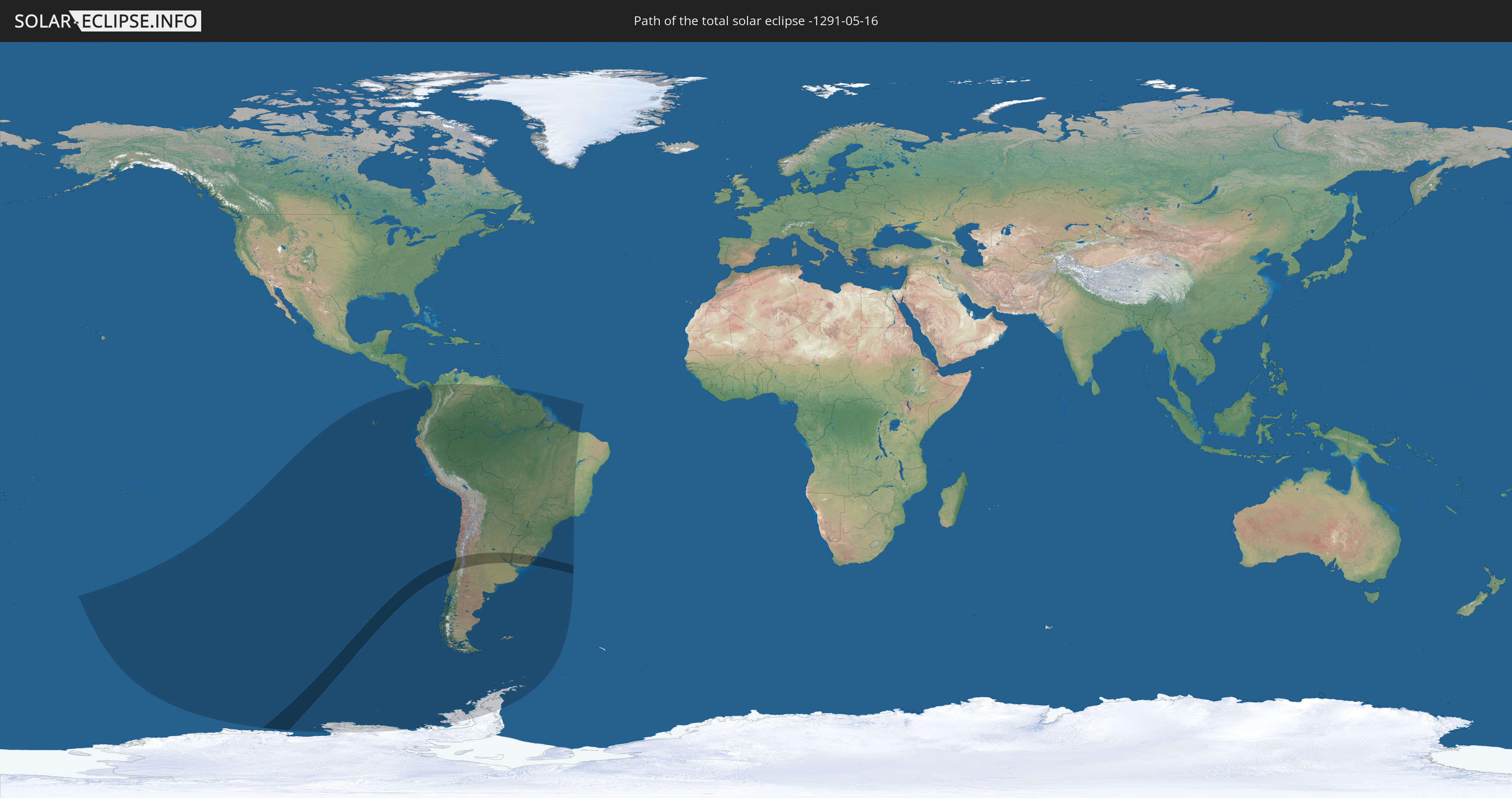
Die Sonnenfinsternis am 05/16/-1291 kann man in 18 Ländern als partielle Sonnenfinsternis beobachten.
Der Finsternispfad verläuft durch 4 Länder. Nur in diesen Ländern ist sie als total Sonnenfinsternis zu sehen.
In den folgenden Ländern ist die Sonnenfinsternis total zu sehen
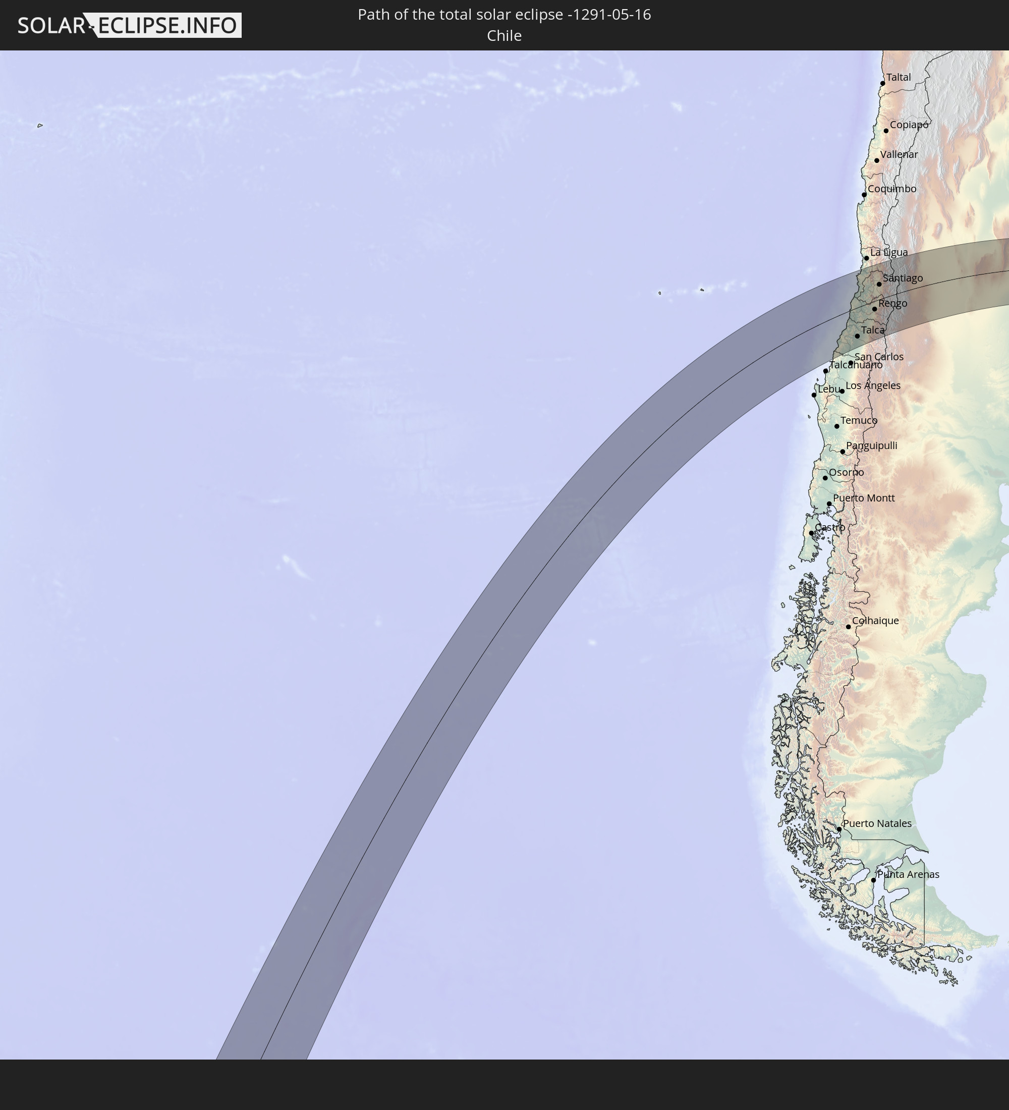 Chile
Chile
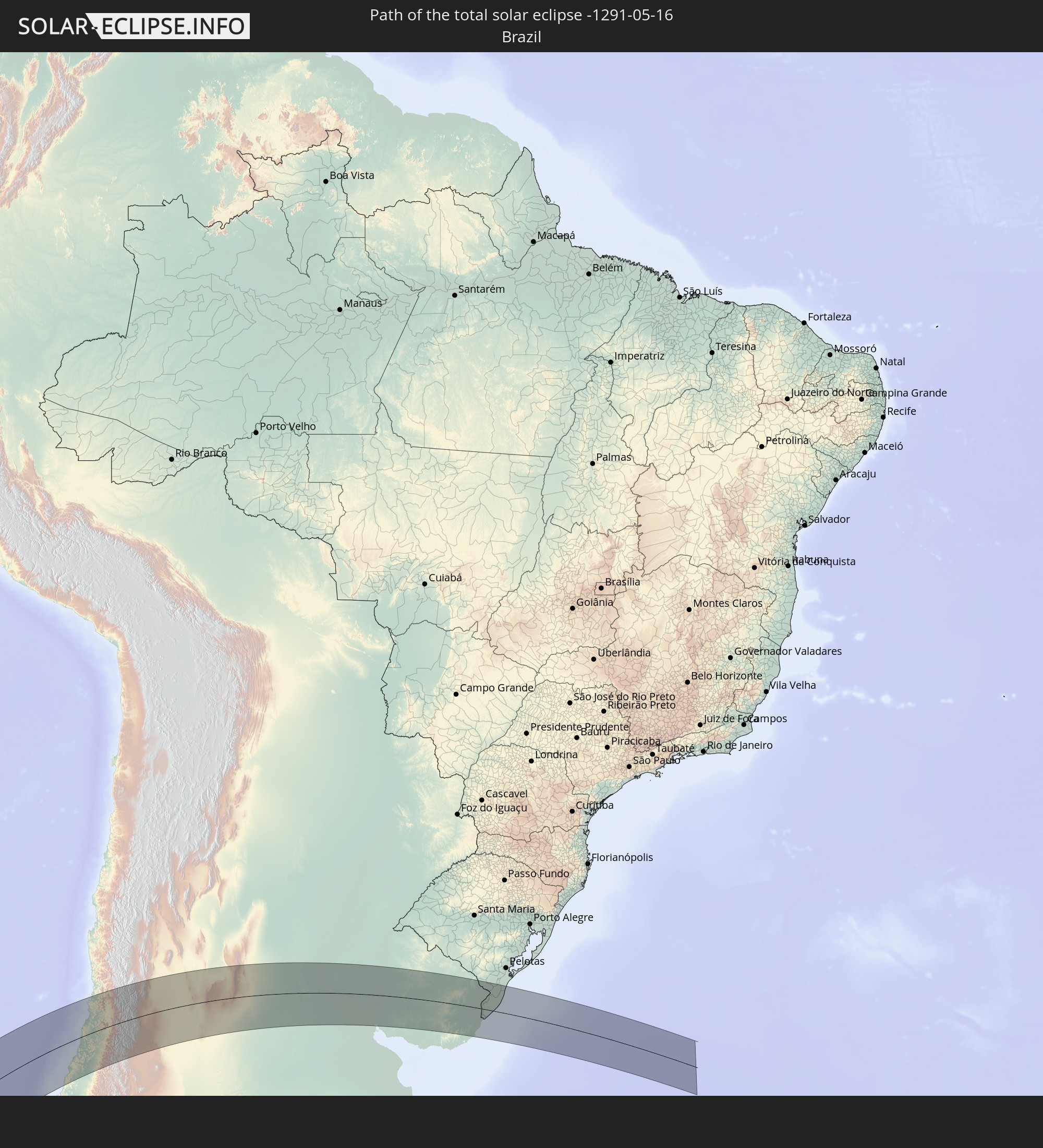 Brazil
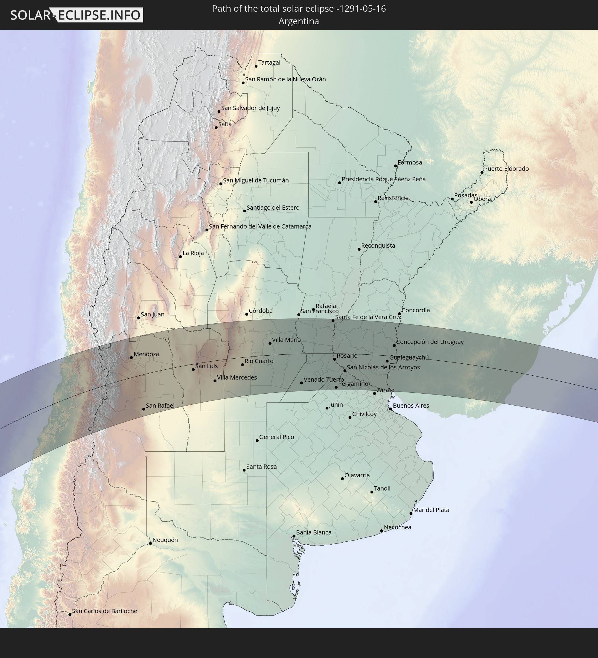 Argentina
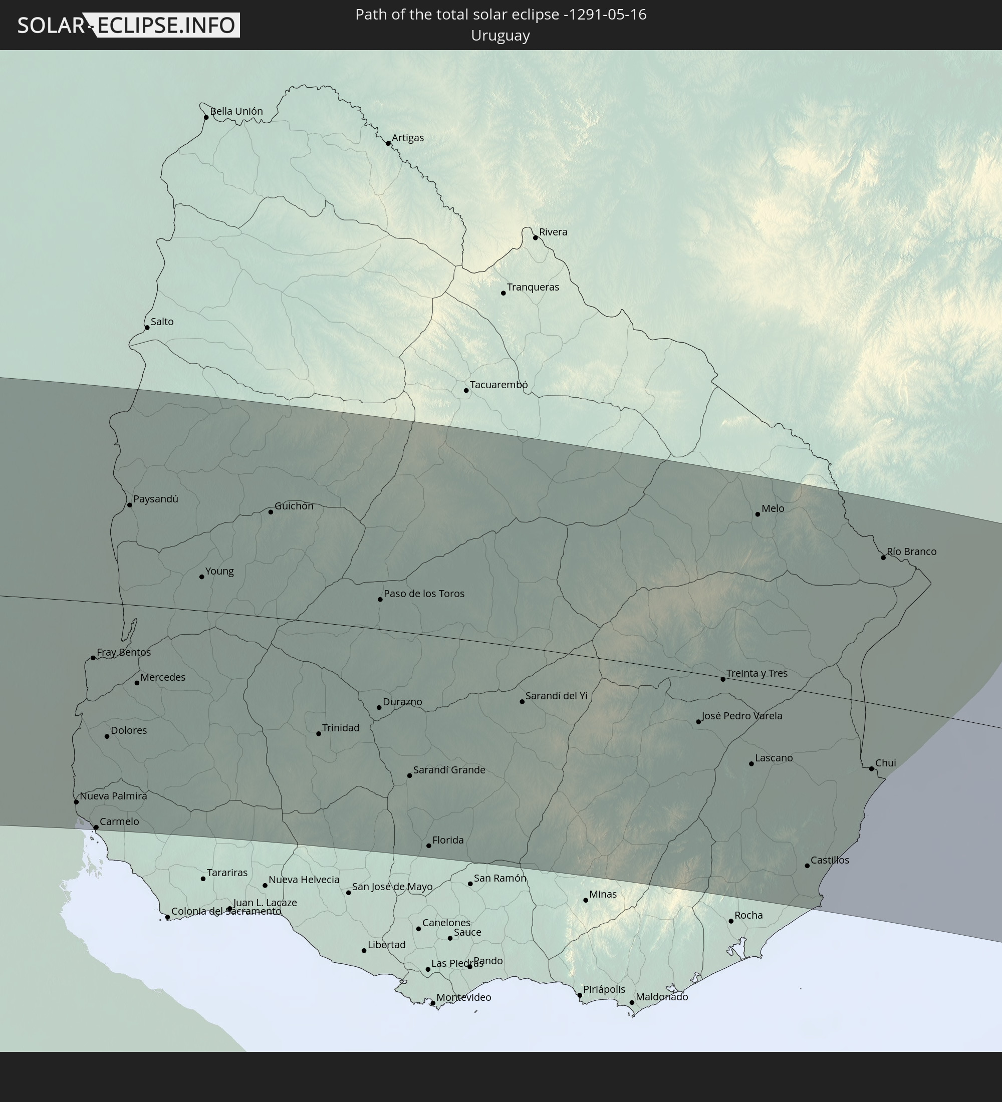 Uruguay
In den folgenden Ländern ist die Sonnenfinsternis partiell zu sehen


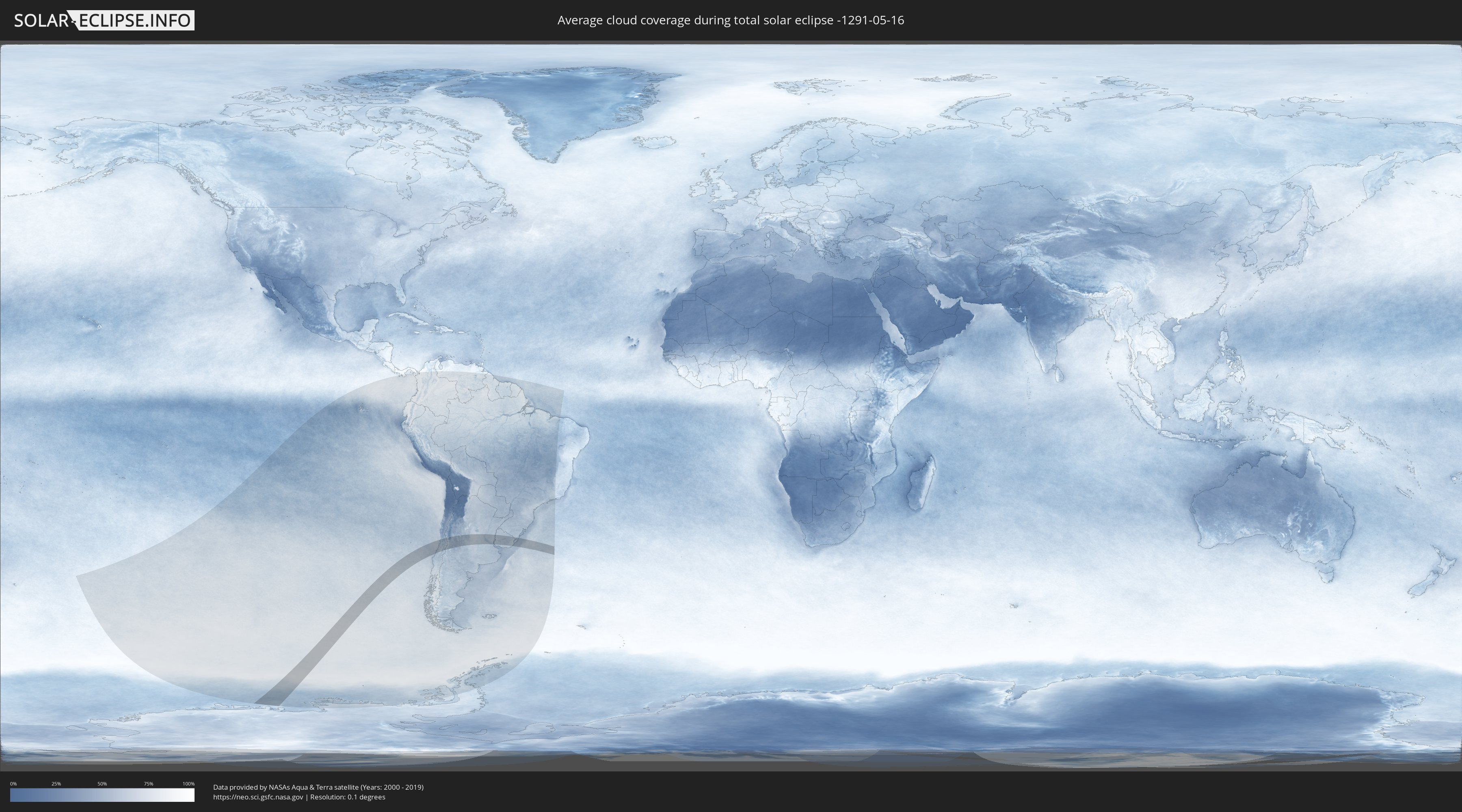
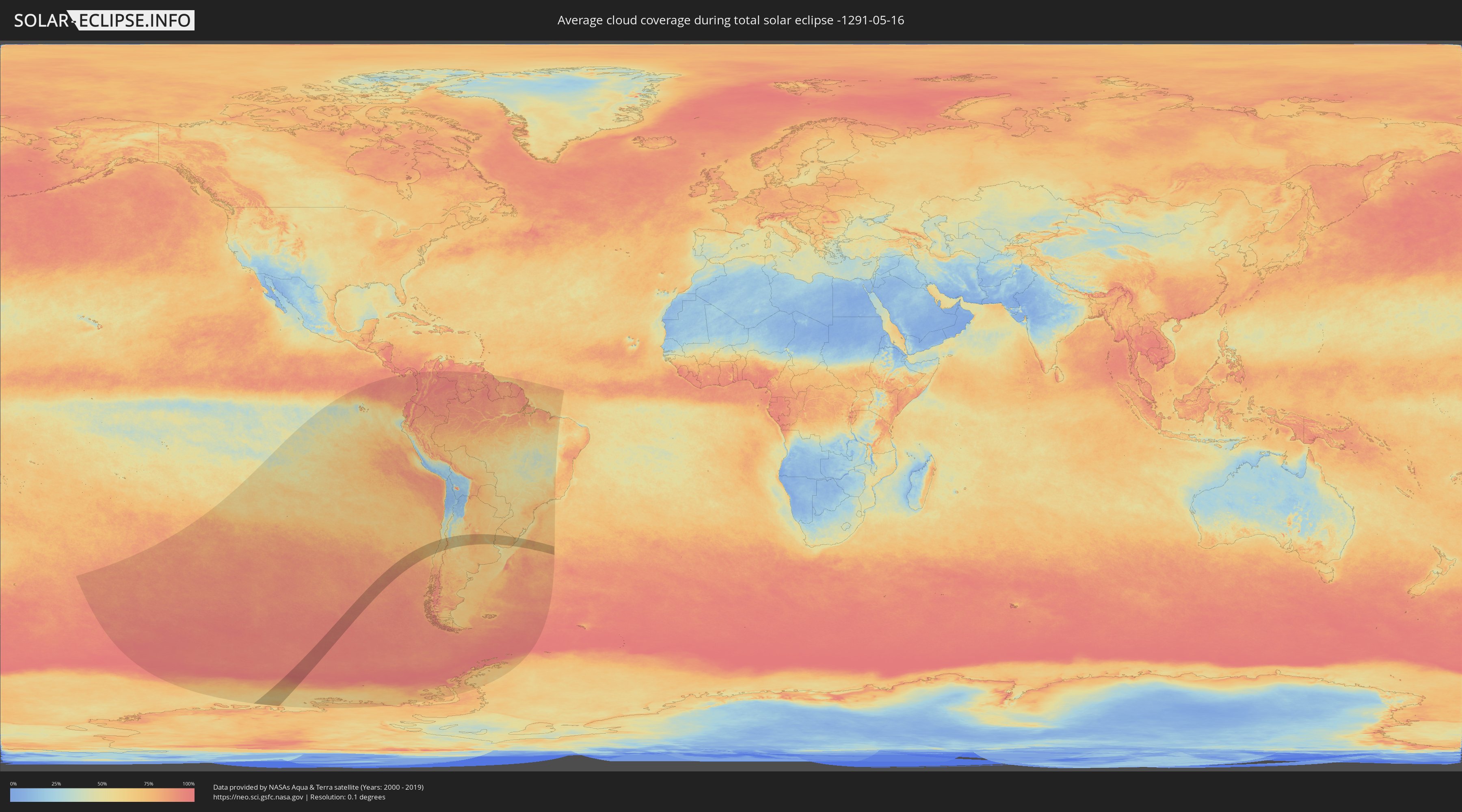
How will be the weather during the total solar eclipse on 05/16/-1291?
Where is the best place to see the total solar eclipse of 05/16/-1291?
The following maps show the average cloud coverage for the day of the total solar eclipse.
With the help of these maps, it is possible to find the place along the eclipse path, which has the best
chance of a cloudless sky.
Nevertheless, you should consider local circumstances and inform about the weather of your chosen
observation site.
The data is provided by NASAs satellites
AQUA and TERRA.
The cloud maps are averaged over a period of 19 years (2000 - 2019).
Detailed country maps
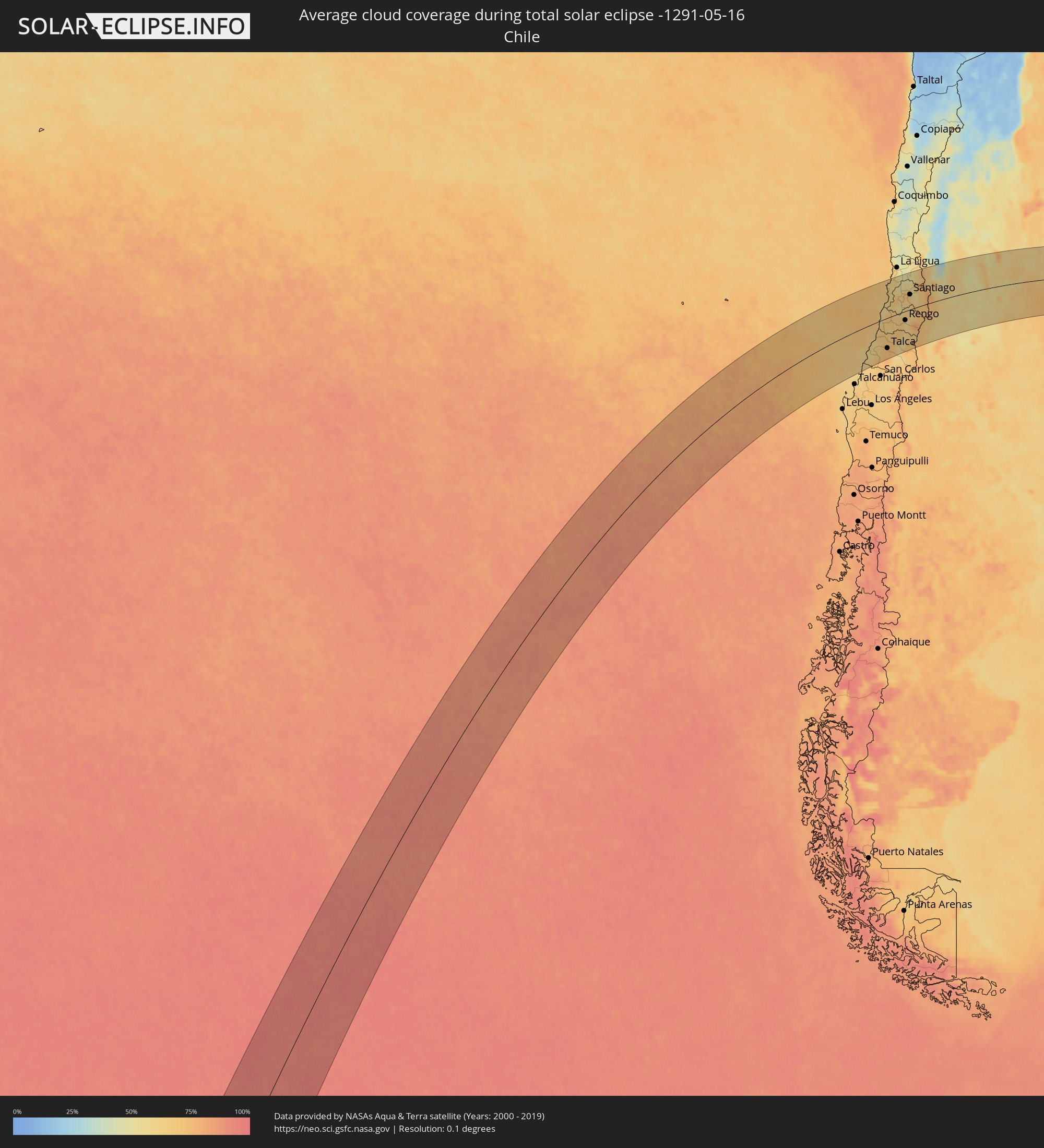 Chile
Chile
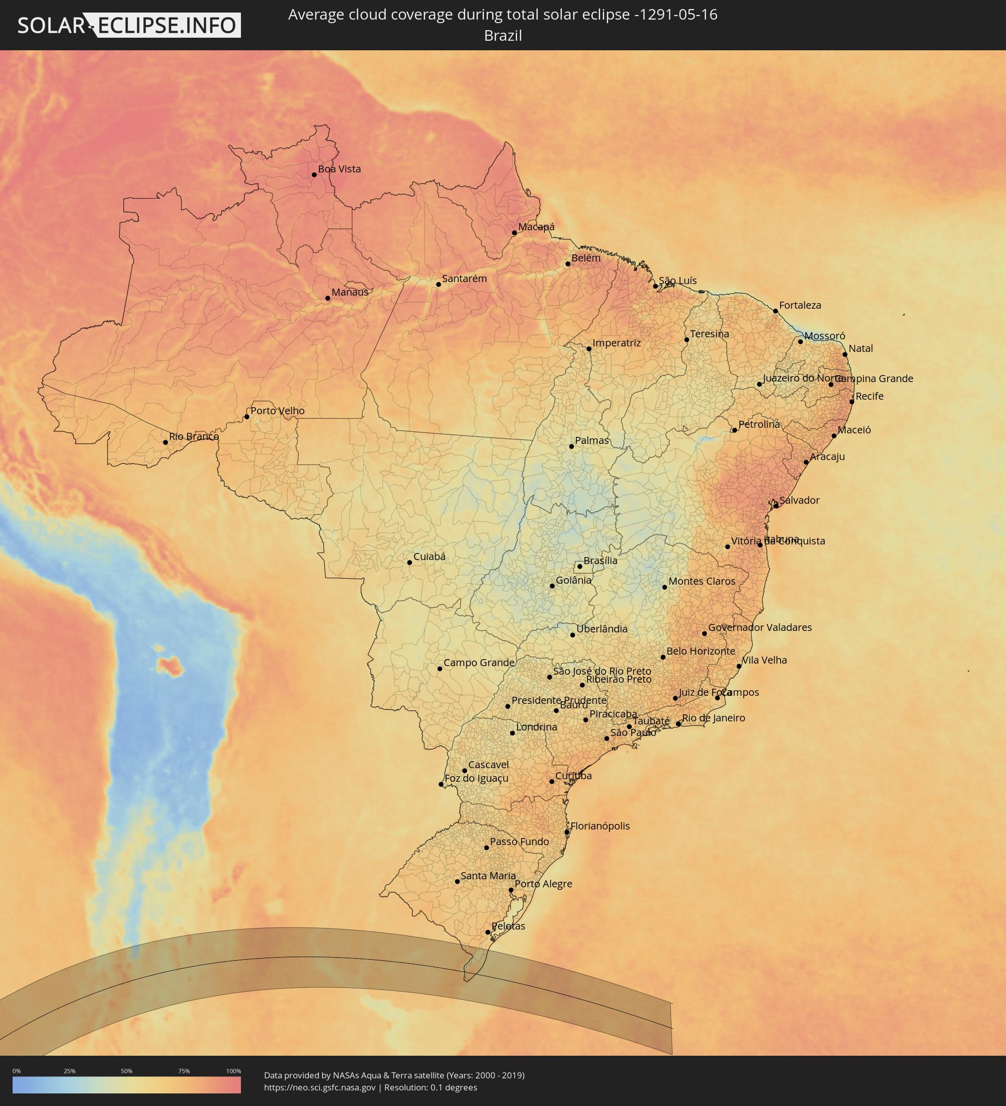 Brazil
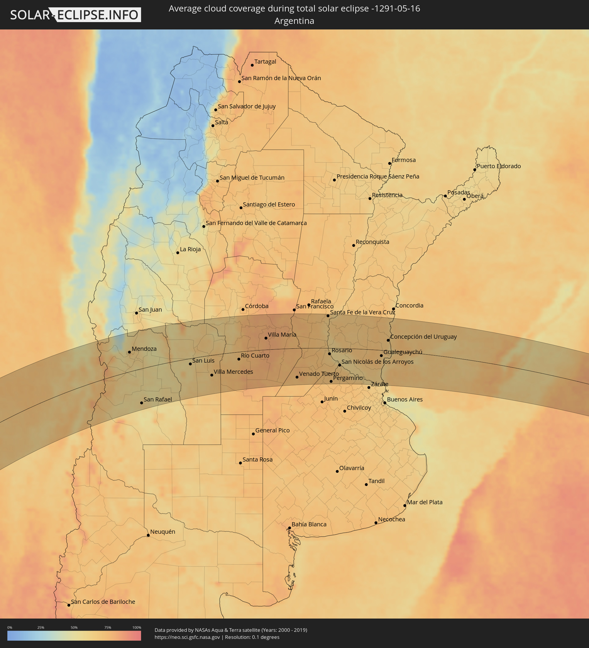 Argentina
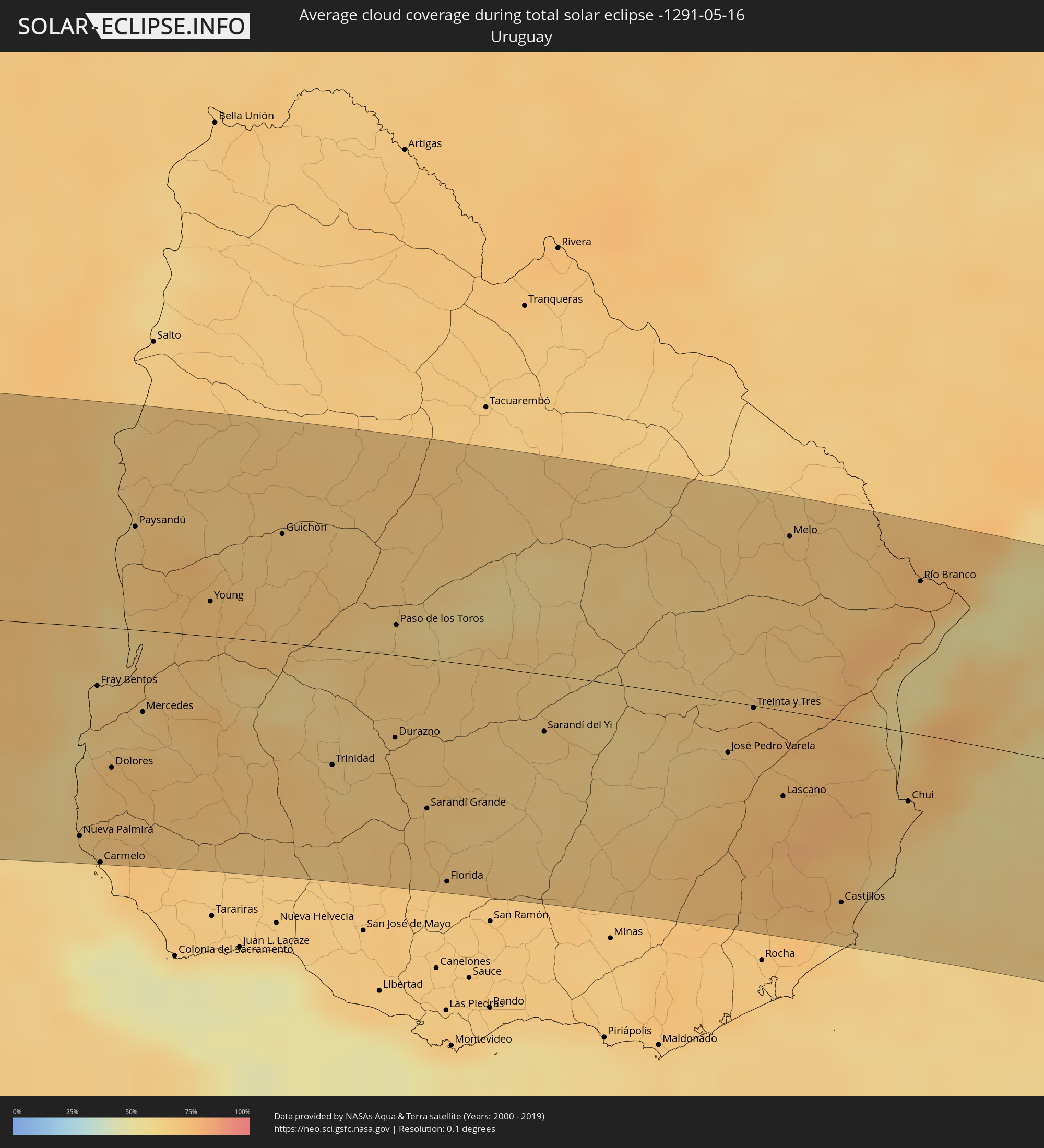 Uruguay
Cities inside the path of the eclipse
The following table shows all locations with a population of more than 5,000 inside the eclipse path. Cities which have more than 100,000 inhabitants are marked bold. A click at the locations opens a detailed map.
| City | Type | Eclipse duration | Local time of max. eclipse | Distance to central line | Ø Cloud coverage |
 Constitución, Maule
|
total | - | 14:47:28 UTC-04:42 | 76 km | 61% |
|
Cauquenes, Maule
|
total | - | 14:46:32 UTC-04:42 | 144 km | 65% |
|
San Javier, Maule
|
total | - | 14:48:04 UTC-04:42 | 128 km | 72% |
|
Talca, Maule
|
total | - | 14:48:28 UTC-04:42 | 114 km | 72% |
|
Valparaíso, Valparaíso
|
total | - | 14:52:33 UTC-04:42 | 133 km | 63% |
|
Cartagena, Valparaíso
|
total | - | 14:51:43 UTC-04:42 | 78 km | 62% |
|
San Antonio, Valparaíso
|
total | - | 14:51:39 UTC-04:42 | 74 km | 62% |
|
Viña del Mar, Valparaíso
|
total | - | 14:52:42 UTC-04:42 | 132 km | 63% |
|
San Clemente, Maule
|
total | - | 14:48:32 UTC-04:42 | 131 km | 73% |
|
Quilpué, Valparaíso
|
total | - | 14:52:50 UTC-04:42 | 126 km | 62% |
|
Villa Alemana, Valparaíso
|
total | - | 14:52:57 UTC-04:42 | 124 km | 62% |
|
Santa Cruz, O'Higgins
|
total | - | 14:50:15 UTC-04:42 | 42 km | 64% |
|
Rauco, Maule
|
total | - | 14:49:50 UTC-04:42 | 74 km | 72% |
|
Molina, Maule
|
total | - | 14:49:34 UTC-04:42 | 94 km | 72% |
|
Limache, Valparaíso
|
total | - | 14:53:09 UTC-04:42 | 124 km | 61% |
|
Quillota, Valparaíso
|
total | - | 14:53:24 UTC-04:42 | 137 km | 59% |
|
Curicó, Maule
|
total | - | 14:49:52 UTC-04:42 | 82 km | 72% |
|
Hacienda La Calera, Valparaíso
|
total | - | 14:53:38 UTC-04:42 | 147 km | 59% |
|
Melipilla, Santiago Metropolitan
|
total | - | 14:52:05 UTC-04:42 | 52 km | 66% |
|
Teno, Maule
|
total | - | 14:50:10 UTC-04:42 | 73 km | 73% |
|
San Vicente, O'Higgins
|
total | - | 14:51:02 UTC-04:42 | 30 km | 66% |
|
San Vicente de Tagua Tagua, O'Higgins
|
total | - | 14:51:02 UTC-04:42 | 31 km | 66% |
|
Chimbarongo, O'Higgins
|
total | - | 14:50:37 UTC-04:42 | 61 km | 71% |
|
El Monte, Santiago Metropolitan
|
total | - | 14:52:28 UTC-04:42 | 45 km | 60% |
|
Llaillay, Valparaíso
|
total | - | 14:53:56 UTC-04:42 | 133 km | 52% |
|
Talagante, Santiago Metropolitan
|
total | - | 14:52:34 UTC-04:42 | 45 km | 64% |
|
Peñaflor, Santiago Metropolitan
|
total | - | 14:52:45 UTC-04:42 | 50 km | 64% |
|
Lampa, Santiago Metropolitan
|
total | - | 14:53:18 UTC-04:42 | 83 km | 62% |
|
Rengo, O'Higgins
|
total | - | 14:51:25 UTC-04:42 | 35 km | 66% |
|
Rancagua, O'Higgins
|
total | - | 14:51:59 UTC-04:42 | 14 km | 66% |
|
Buin, Santiago Metropolitan
|
total | - | 14:52:44 UTC-04:42 | 32 km | 64% |
|
Paine, Santiago Metropolitan
|
total | - | 14:52:37 UTC-04:42 | 25 km | 62% |
|
Graneros, O'Higgins
|
total | - | 14:52:11 UTC-04:42 | 3 km | 65% |
|
San Felipe, Valparaíso
|
total | - | 14:54:26 UTC-04:42 | 136 km | 53% |
|
Lo Prado, Santiago Metropolitan
|
total | - | 14:53:15 UTC-04:42 | 62 km | 71% |
|
San Bernardo, Santiago Metropolitan
|
total | - | 14:53:03 UTC-04:42 | 46 km | 64% |
|
Chicureo Abajo, Santiago Metropolitan
|
total | - | 14:53:38 UTC-04:42 | 77 km | 68% |
|
Machalí, O'Higgins
|
total | - | 14:52:07 UTC-04:42 | 17 km | 59% |
|
Santiago, Santiago Metropolitan
|
total | - | 14:53:21 UTC-04:42 | 59 km | 67% |
|
La Pintana, Santiago Metropolitan
|
total | - | 14:53:09 UTC-04:42 | 45 km | 64% |
|
Los Andes, Valparaíso
|
total | - | 14:54:29 UTC-04:42 | 123 km | 53% |
|
Villa Presidente Frei, Ñuñoa, Santiago, Chile, Santiago Metropolitan
|
total | - | 14:53:27 UTC-04:42 | 56 km | 67% |
|
Puente Alto, Santiago Metropolitan
|
total | - | 14:53:12 UTC-04:42 | 40 km | 64% |
 Mendoza, Mendoza Province
|
total | - | 15:22:59 UTC-04:16 | 71 km | 67% |
|
San Martín, Mendoza Province
|
total | - | 15:23:11 UTC-04:16 | 42 km | 61% |
|
San Rafael, Mendoza Province
|
total | - | 15:20:45 UTC-04:16 | 127 km | 62% |
|
San Luis, San Luis Province
|
total | - | 15:25:47 UTC-04:16 | 22 km | 60% |
|
Villa Mercedes, San Luis Province
|
total | - | 15:26:19 UTC-04:16 | 76 km | 68% |
|
Villa Dolores, Cordoba Province
|
total | - | 15:29:37 UTC-04:16 | 111 km | 62% |
|
Merlo, San Luis Province
|
total | - | 15:29:11 UTC-04:16 | 65 km | 60% |
|
Alta Gracia, Cordoba Province
|
total | - | 15:31:06 UTC-04:16 | 136 km | 70% |
|
Embalse, Cordoba Province
|
total | - | 15:30:13 UTC-04:16 | 77 km | 66% |
|
Río Cuarto, Cordoba Province
|
total | - | 15:28:41 UTC-04:16 | 29 km | 72% |
|
Almafuerte, Cordoba Province
|
total | - | 15:30:25 UTC-04:16 | 74 km | 71% |
|
Río Tercero, Cordoba Province
|
total | - | 15:30:37 UTC-04:16 | 75 km | 77% |
|
Río Segundo, Cordoba Province
|
total | - | 15:31:46 UTC-04:16 | 131 km | 78% |
|
Pilar, Cordoba Province
|
total | - | 15:31:45 UTC-04:16 | 128 km | 78% |
|
Hernando, Cordoba Province
|
total | - | 15:30:40 UTC-04:16 | 44 km | 78% |
|
Oncativo, Cordoba Province
|
total | - | 15:31:36 UTC-04:16 | 101 km | 79% |
|
Oliva, Cordoba Province
|
total | - | 15:31:32 UTC-04:16 | 86 km | 79% |
|
La Carlota, Cordoba Province
|
total | - | 15:29:31 UTC-04:16 | 69 km | 79% |
|
Villa María, Cordoba Province
|
total | - | 15:31:19 UTC-04:16 | 43 km | 80% |
|
Las Varillas, Cordoba Province
|
total | - | 15:32:51 UTC-04:16 | 100 km | 79% |
|
Bell Ville, Cordoba Province
|
total | - | 15:31:37 UTC-04:16 | 16 km | 78% |
|
Marcos Juárez, Cordoba Province
|
total | - | 15:32:11 UTC-04:16 | 6 km | 77% |
|
Venado Tuerto, Santa Fe Province
|
total | - | 15:30:34 UTC-04:16 | 111 km | 72% |
|
San Jorge, Santa Fe Province
|
total | - | 15:33:50 UTC-04:16 | 95 km | 76% |
|
El Trébol, Santa Fe Province
|
total | - | 15:33:30 UTC-04:16 | 60 km | 75% |
|
Las Rosas, Santa Fe Province
|
total | - | 15:33:11 UTC-04:16 | 29 km | 72% |
|
Las Parejas, Santa Fe Province
|
total | - | 15:32:54 UTC-04:16 | 6 km | 73% |
|
Firmat, Santa Fe Province
|
total | - | 15:31:37 UTC-04:16 | 80 km | 73% |
|
Cañada de Gómez, Santa Fe Province
|
total | - | 15:32:49 UTC-04:16 | 9 km | 73% |
|
Gálvez, Santa Fe Province
|
total | - | 15:34:21 UTC-04:16 | 79 km | 73% |
|
Casilda, Santa Fe Province
|
total | - | 15:32:41 UTC-04:16 | 34 km | 72% |
|
Carcarañá, Santa Fe Province
|
total | - | 15:33:02 UTC-04:16 | 13 km | 73% |
|
Coronda, Santa Fe Province
|
total | - | 15:34:48 UTC-04:16 | 85 km | 63% |
|
Roldán, Santa Fe Province
|
total | - | 15:33:14 UTC-04:16 | 18 km | 70% |
|
Capitán Bermúdez, Santa Fe Province
|
total | - | 15:33:35 UTC-04:16 | 9 km | 65% |
|
Santa Fe de la Vera Cruz, Santa Fe Province
|
total | - | 15:35:37 UTC-04:16 | 123 km | 66% |
|
Rosario, Santa Fe Province
|
total | - | 15:33:27 UTC-04:16 | 23 km | 61% |
|
Diamante, Entre Ríos Province
|
total | - | 15:34:57 UTC-04:16 | 75 km | 65% |
|
Pergamino, Buenos Aires
|
total | - | 15:31:55 UTC-04:16 | 128 km | 71% |
|
Paraná, Entre Ríos Province
|
total | - | 15:35:39 UTC-04:16 | 112 km | 67% |
|
Arroyo Seco, Santa Fe Province
|
total | - | 15:33:15 UTC-04:16 | 46 km | 68% |
|
Villa Constitución, Santa Fe Province
|
total | - | 15:33:19 UTC-04:16 | 54 km | 63% |
|
Crespo, Entre Ríos Province
|
total | - | 15:35:23 UTC-04:16 | 80 km | 70% |
|
San Nicolás de los Arroyos, Buenos Aires
|
total | - | 15:33:15 UTC-04:16 | 66 km | 64% |
|
Victoria, Entre Ríos Province
|
total | - | 15:34:33 UTC-04:16 | 14 km | 61% |
|
Gualeguay, Entre Ríos Province
|
total | - | 15:34:35 UTC-04:16 | 41 km | 68% |
|
Rosario del Tala, Entre Ríos Province
|
total | - | 15:36:11 UTC-04:16 | 53 km | 67% |
|
Villaguay, Entre Ríos Province
|
total | - | 15:37:02 UTC-04:16 | 102 km | 69% |
|
Gualeguaychú, Entre Ríos Province
|
total | - | 15:35:39 UTC-04:16 | 22 km | 64% |
 Nueva Palmira, Colonia
|
total | - | 16:06:14 UTC-03:44 | 117 km | 61% |
|
Fray Bentos, Río Negro
|
total | - | 16:07:37 UTC-03:44 | 33 km | 64% |
|
Carmelo, Colonia
|
total | - | 16:06:09 UTC-03:44 | 130 km | 58% |
|
Concepción del Uruguay, Entre Ríos Province
|
total | - | 15:36:49 UTC-04:16 | 39 km | 64% |
|
Dolores, Soriano
|
total | - | 16:07:01 UTC-03:44 | 77 km | 71% |
|
Paysandú, Paysandú
|
total | - | 16:09:12 UTC-03:44 | 58 km | 66% |
|
Mercedes, Soriano
|
total | - | 16:07:41 UTC-03:44 | 45 km | 69% |
|
Young, Río Negro
|
total | - | 16:09:01 UTC-03:44 | 19 km | 71% |
|
Guichón, Paysandú
|
total | - | 16:10:01 UTC-03:44 | 61 km | 67% |
|
Trinidad, Flores
|
total | - | 16:08:21 UTC-03:44 | 64 km | 65% |
|
Trinidad, Flores
|
total | - | 16:08:20 UTC-03:44 | 67 km | 65% |
|
Durazno, Durazno
|
total | - | 16:08:57 UTC-03:44 | 46 km | 68% |
|
Paso de los Toros, Tacuarembó
|
total | - | 16:09:54 UTC-03:44 | 17 km | 64% |
|
Sarandí Grande, Florida
|
total | - | 16:08:32 UTC-03:44 | 82 km | 67% |
|
Florida, Florida
|
total | - | 16:08:02 UTC-03:44 | 121 km | 67% |
|
Sarandí del Yi, Durazno
|
total | - | 16:09:50 UTC-03:44 | 32 km | 64% |
|
José Pedro Varela, Lavalleja
|
total | - | 16:10:38 UTC-03:44 | 28 km | 72% |
|
Treinta y Tres, Treinta y Tres
|
total | - | 16:11:09 UTC-03:44 | 1 km | 74% |
|
Lascano, Rocha
|
total | - | 16:10:34 UTC-03:44 | 47 km | 74% |
|
Melo, Cerro Largo
|
total | - | 16:12:46 UTC-03:44 | 97 km | 69% |
|
Castillos, Rocha
|
total | - | 16:09:58 UTC-03:44 | 99 km | 69% |
|
Chui, Rocha
|
total | - | 16:11:09 UTC-03:44 | 38 km | 70% |
 Chuí, Rio Grande do Sul
|
total | - | 16:11:10 UTC-03:44 | 37 km | 70% |
|
Río Branco, Cerro Largo
|
total | - | 16:13:02 UTC-03:44 | 84 km | 76% |
|
Jaguarão, Rio Grande do Sul
|
total | - | 16:51:29 UTC-03:06 | 88 km | 76% |
|
Santa Vitória do Palmar, Rio Grande do Sul
|
total | - | 16:49:54 UTC-03:06 | 16 km | 73% |