Total solar eclipse of 06/01/-1477
| Day of week: | Sunday |
| Maximum duration of eclipse: | 04m33s |
| Maximum width of eclipse path: | 267 km |
| Saros cycle: | 33 |
| Coverage: | 100% |
| Magnitude: | 1.0662 |
| Gamma: | 0.5914 |
Wo kann man die Sonnenfinsternis vom 06/01/-1477 sehen?
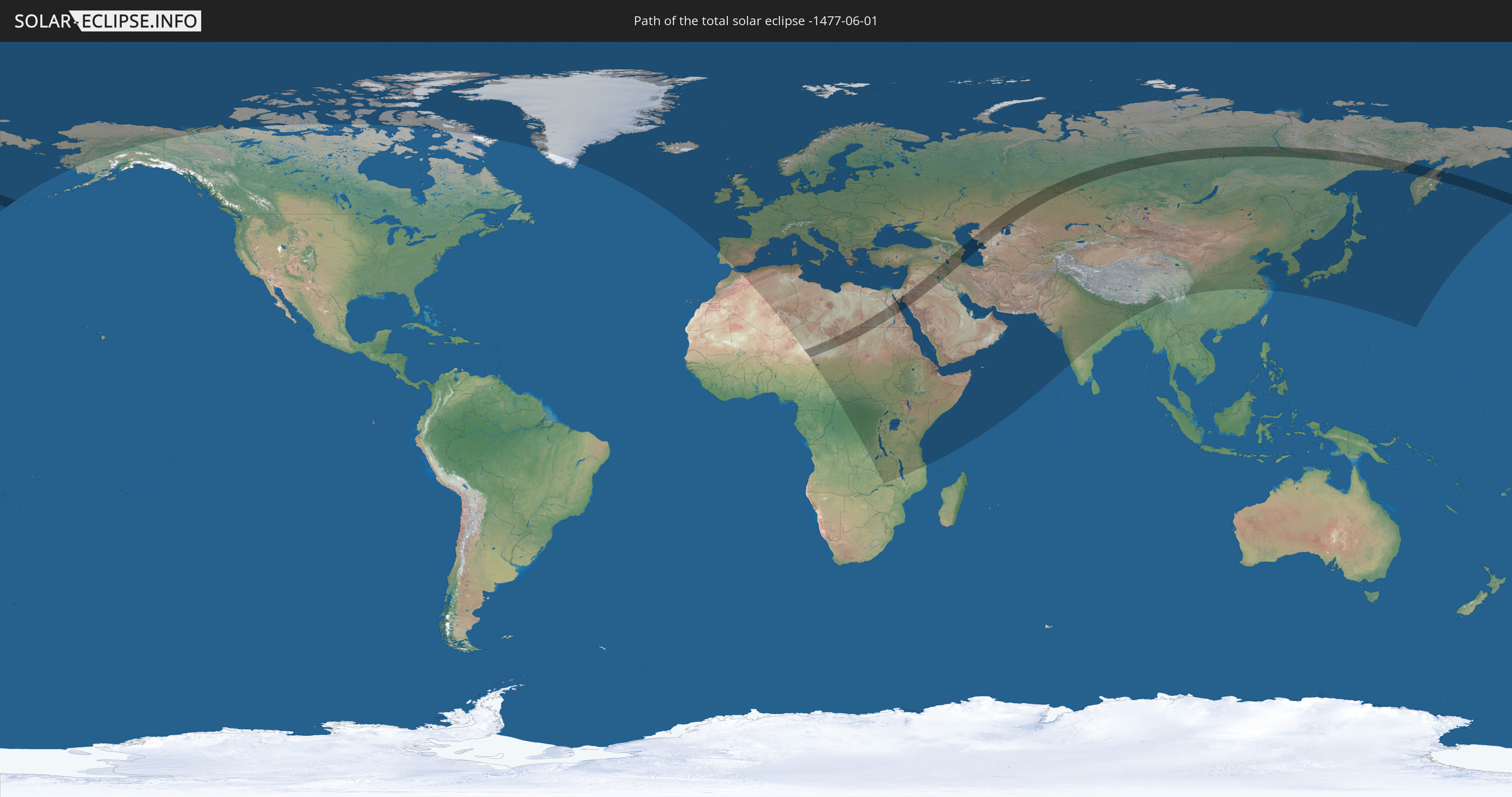
Die Sonnenfinsternis am 06/01/-1477 kann man in 113 Ländern als partielle Sonnenfinsternis beobachten.
Der Finsternispfad verläuft durch 17 Länder. Nur in diesen Ländern ist sie als total Sonnenfinsternis zu sehen.
In den folgenden Ländern ist die Sonnenfinsternis total zu sehen
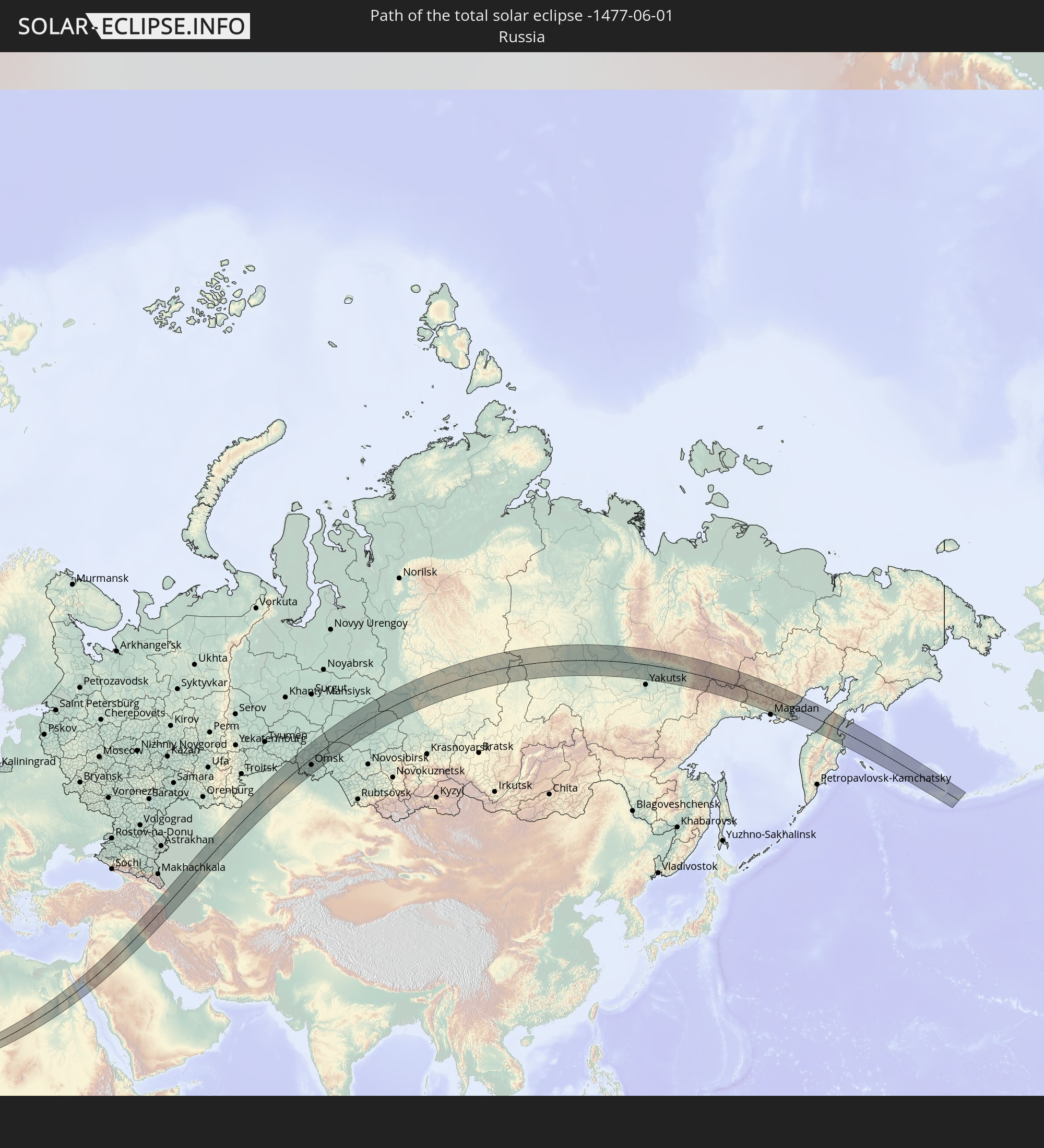 Russia
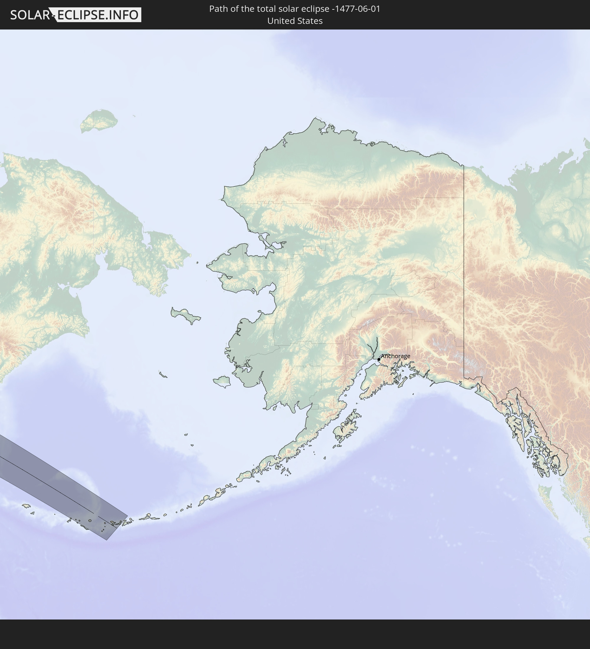 United States
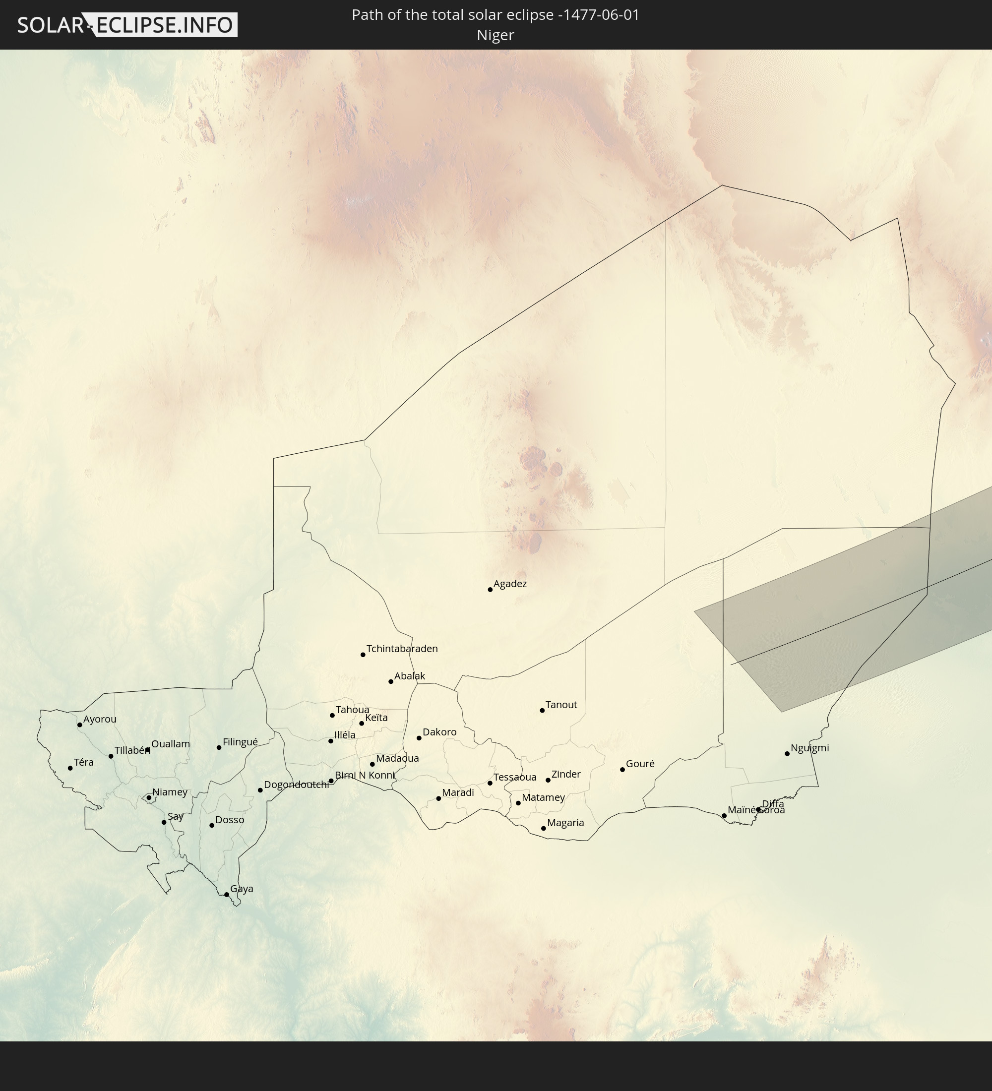 Niger
Niger
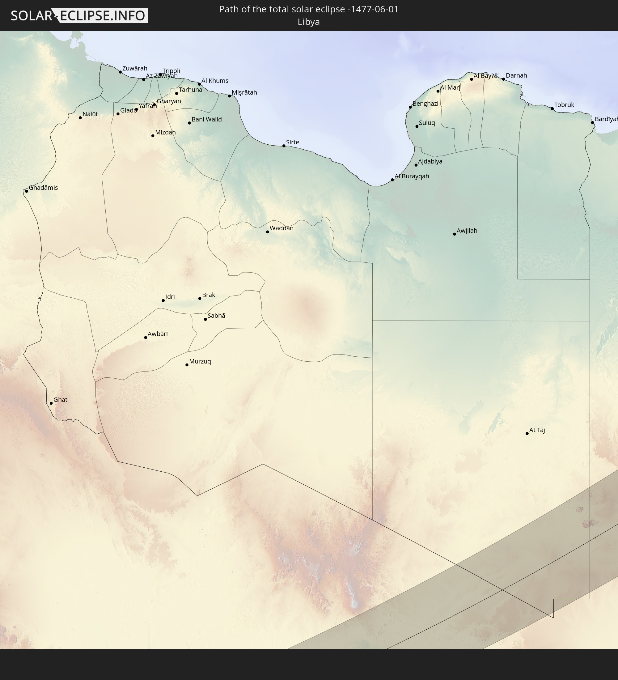 Libya
Libya
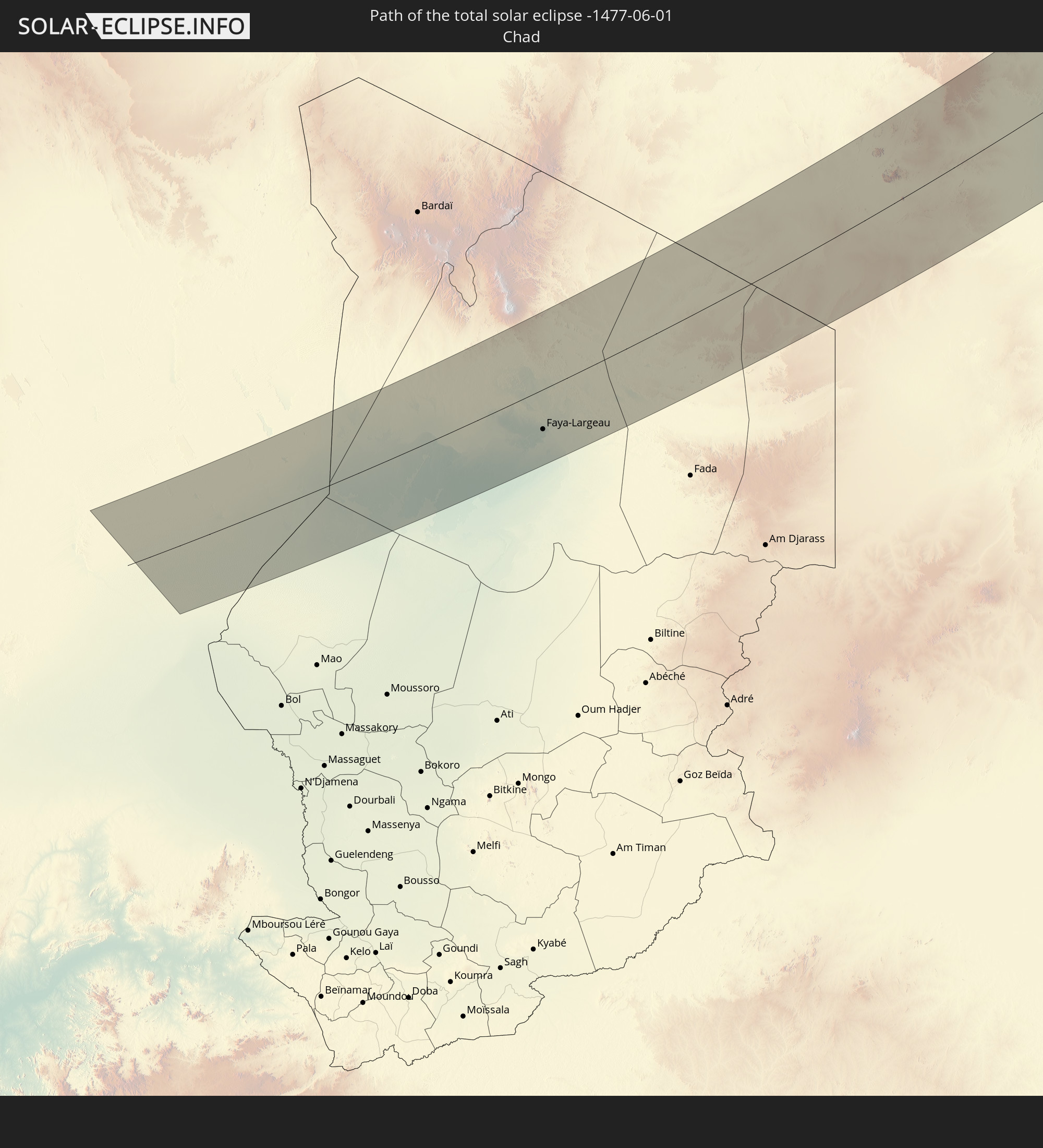 Chad
Chad
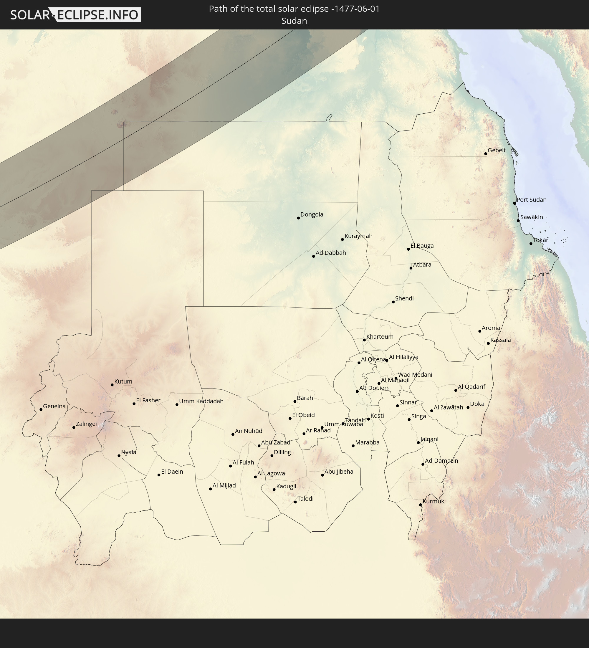 Sudan
Sudan
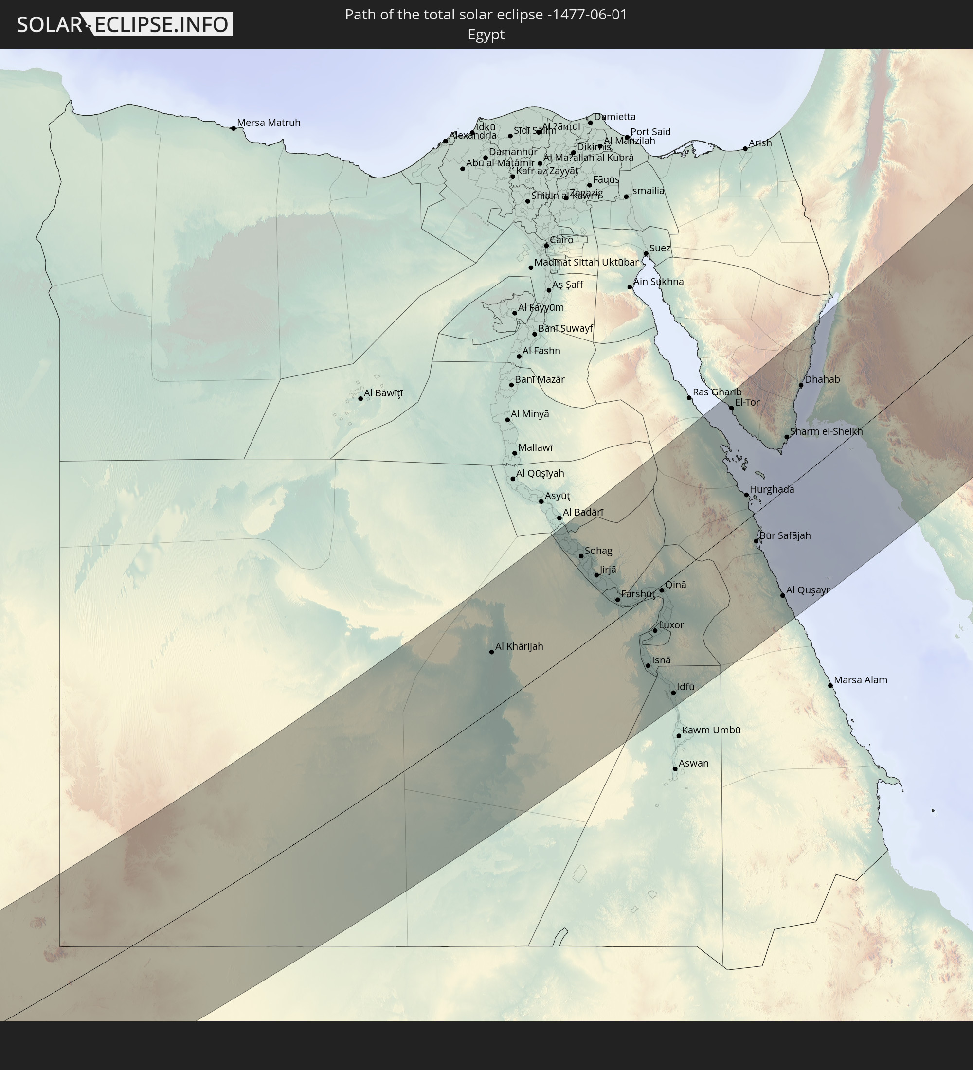 Egypt
Egypt
 Turkey
 Saudi Arabia
 Jordan
 Iraq
Iraq
 Armenia
 Iran
Iran
 Azerbaijan
 Kazakhstan
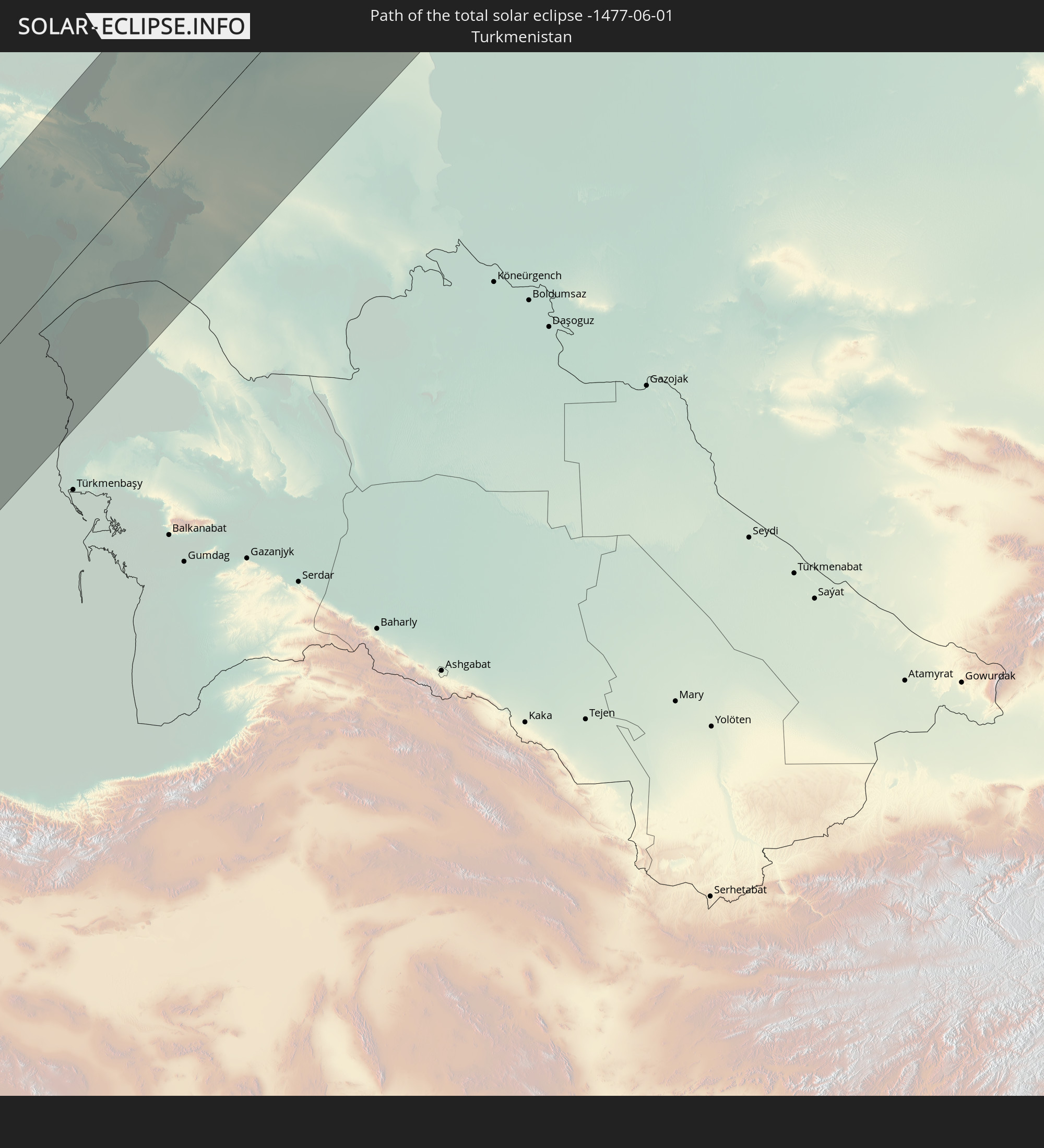 Turkmenistan
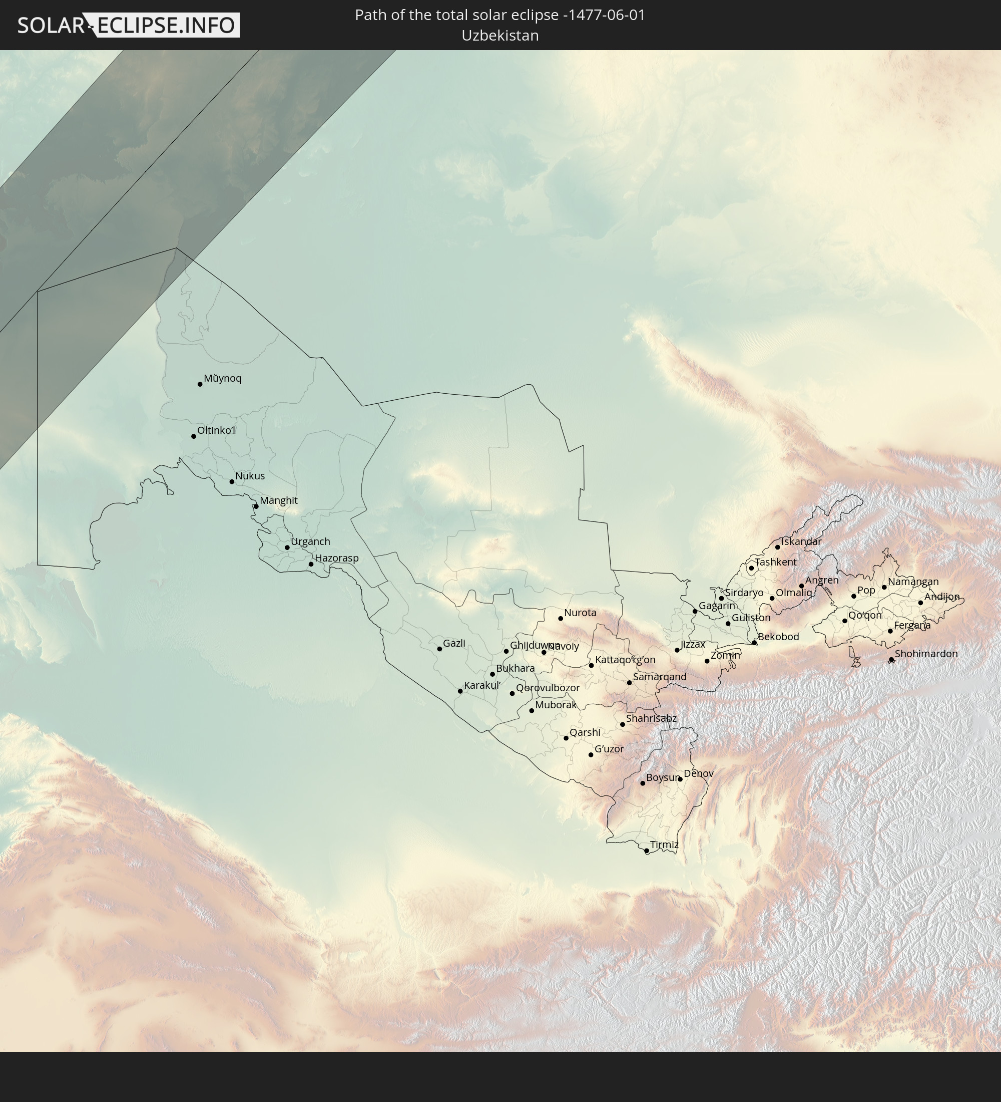 Uzbekistan
In den folgenden Ländern ist die Sonnenfinsternis partiell zu sehen
 Russia
 United States
 Canada
 Greenland
 Portugal
 Iceland
 Spain
Spain
 Morocco
 Republic of Ireland
 Svalbard and Jan Mayen
 Algeria
 United Kingdom
 Faroe Islands
 France
 Isle of Man
 Guernsey
 Jersey
 Niger
Niger
 Andorra
 Belgium
 Nigeria
 Netherlands
 Norway
 Luxembourg
 Germany
 Switzerland
 Italy
Italy
 Monaco
 Tunisia
 Denmark
 Cameroon
 Libya
Libya
 Liechtenstein
 Austria
 Sweden
 Czechia
 Democratic Republic of the Congo
 San Marino
 Vatican City
 Slovenia
 Chad
Chad
 Croatia
 Poland
 Malta
Malta
 Central African Republic
 Bosnia and Herzegovina
 Hungary
 Slovakia
 Montenegro
 Serbia
 Albania
 Åland Islands
 Greece
 Romania
 Republic of Macedonia
 Finland
 Lithuania
 Latvia
 Estonia
 Sudan
Sudan
 Zambia
 Ukraine
 Bulgaria
 Belarus
 Egypt
Egypt
 Turkey
 Moldova
 Rwanda
 Burundi
 Tanzania
 Uganda
 Mozambique
 Cyprus
 Malawi
 Ethiopia
 Kenya
Kenya
 State of Palestine
 Israel
 Saudi Arabia
 Jordan
 Lebanon
 Syria
Syria
 Eritrea
 Iraq
Iraq
 Georgia
 Somalia
 Djibouti
 Yemen
Yemen
 Armenia
 Iran
Iran
 Azerbaijan
 Kazakhstan
 Kuwait
 Bahrain
 Qatar
Qatar
 United Arab Emirates
 Oman
Oman
 Turkmenistan
 Uzbekistan
 Afghanistan
 Pakistan
 Tajikistan
 India
India
 Kyrgyzstan
 China
China
 Nepal
Nepal
 Mongolia
 Bangladesh
 Bhutan
 Myanmar
 Japan
Japan
 North Korea
 South Korea
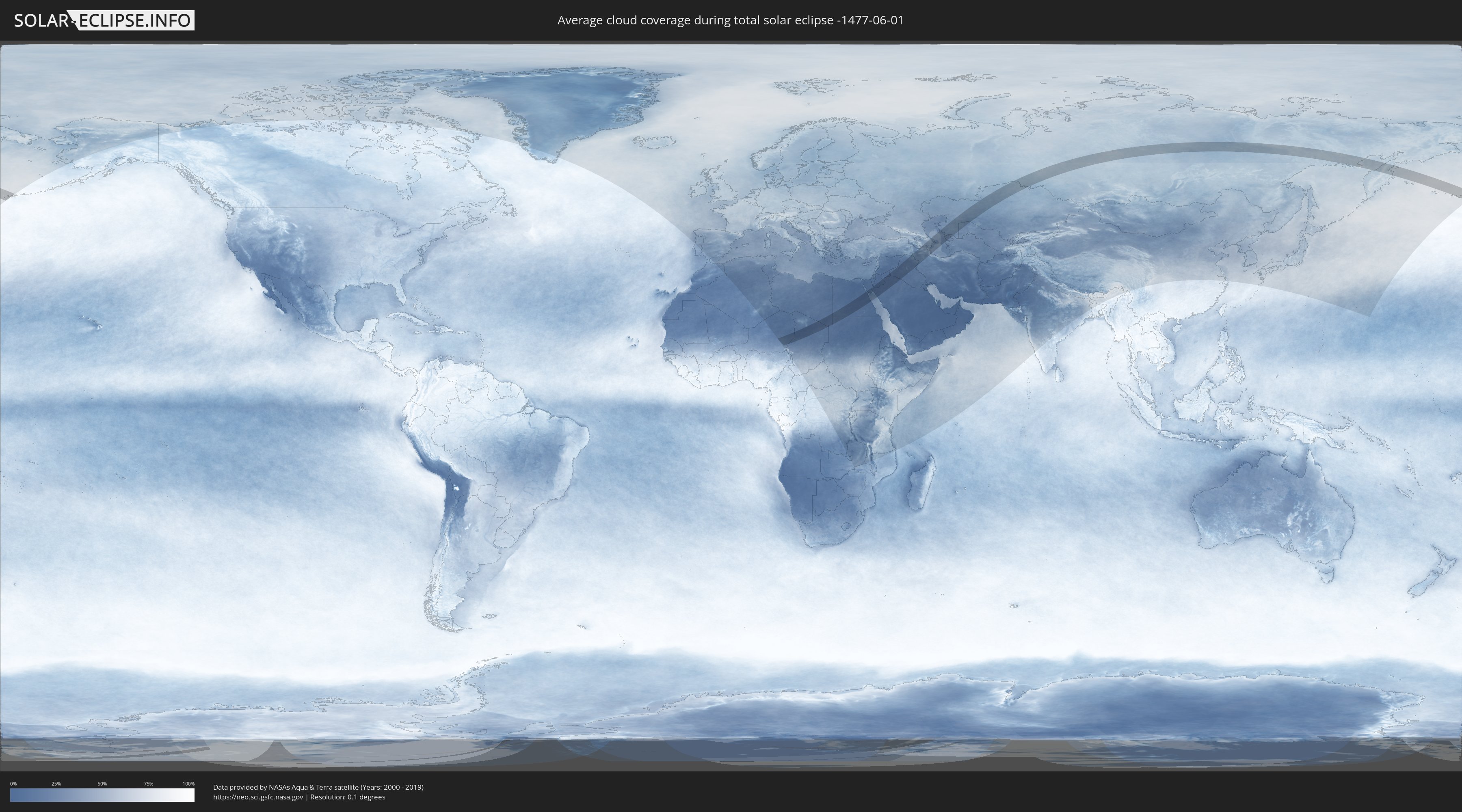
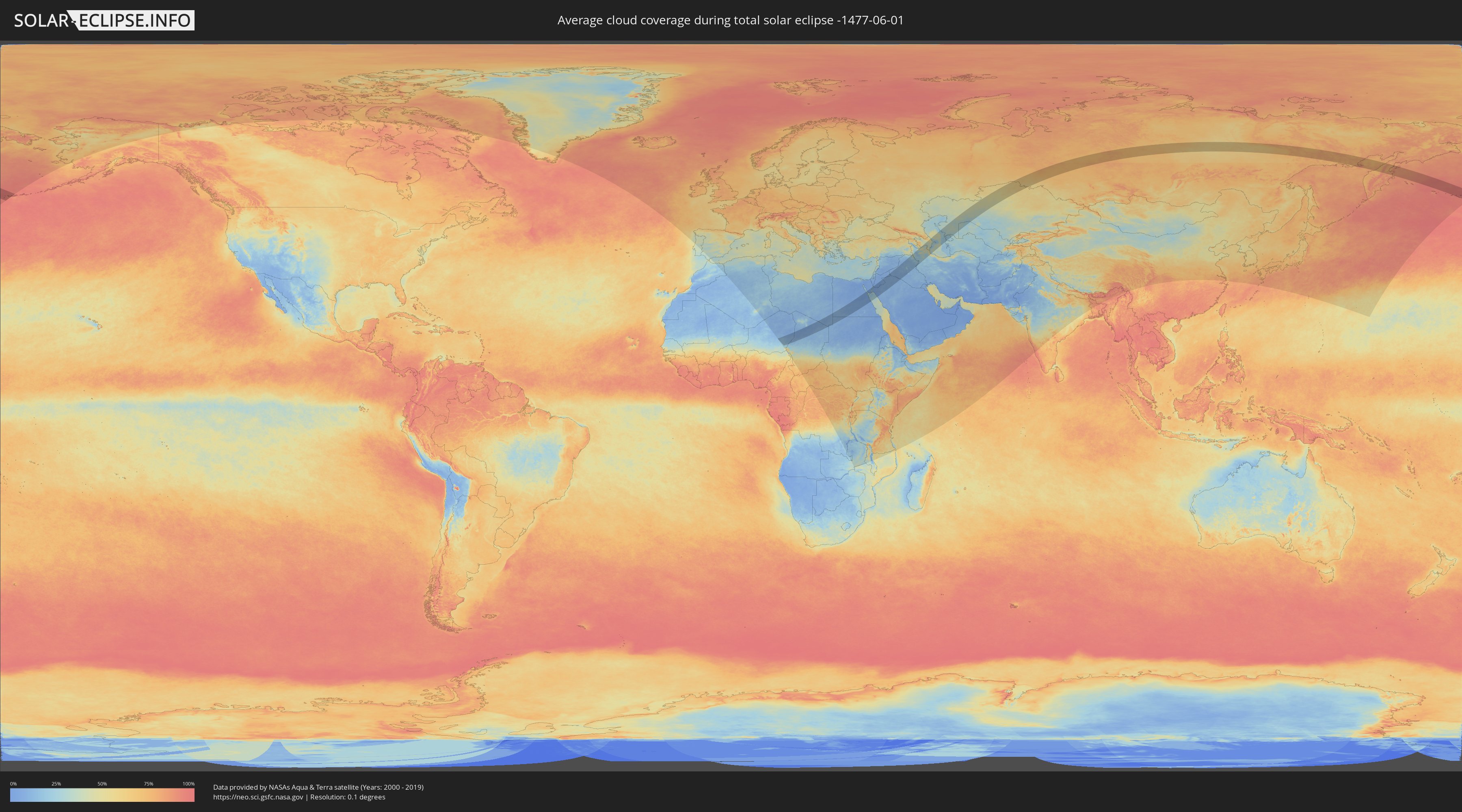
How will be the weather during the total solar eclipse on 06/01/-1477?
Where is the best place to see the total solar eclipse of 06/01/-1477?
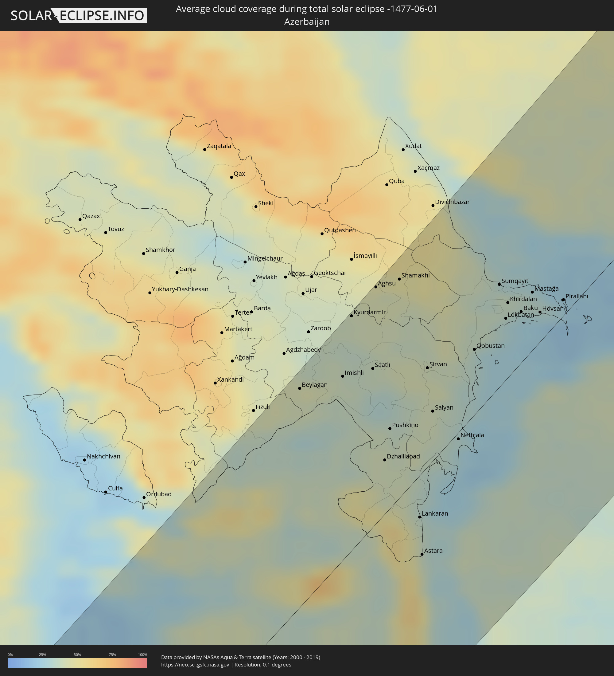
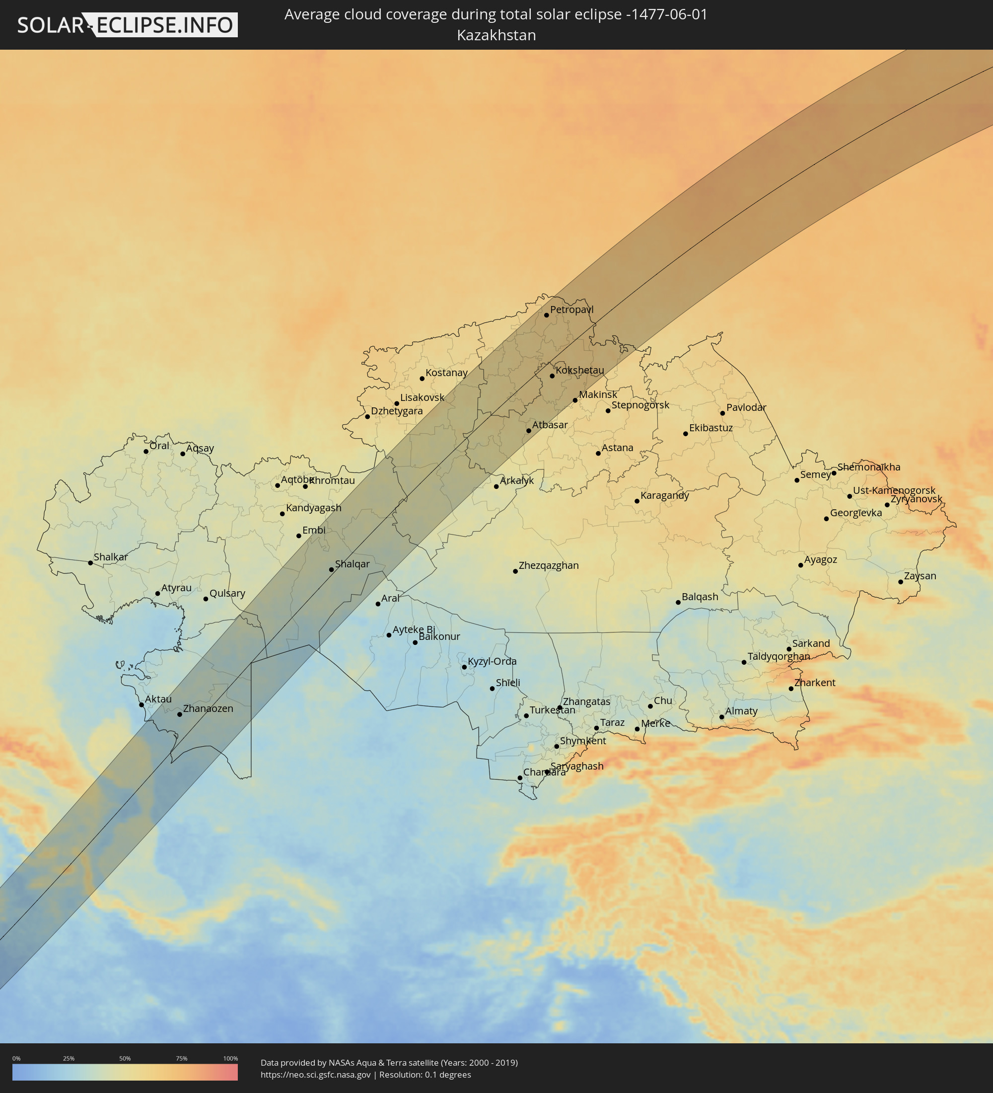
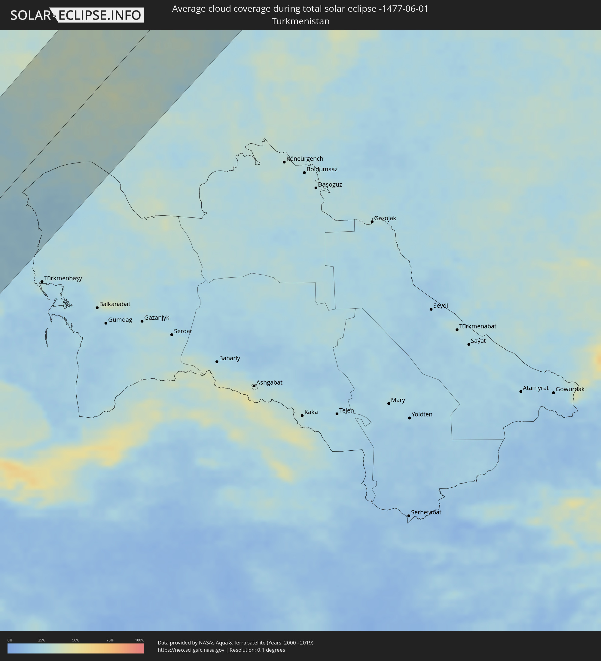
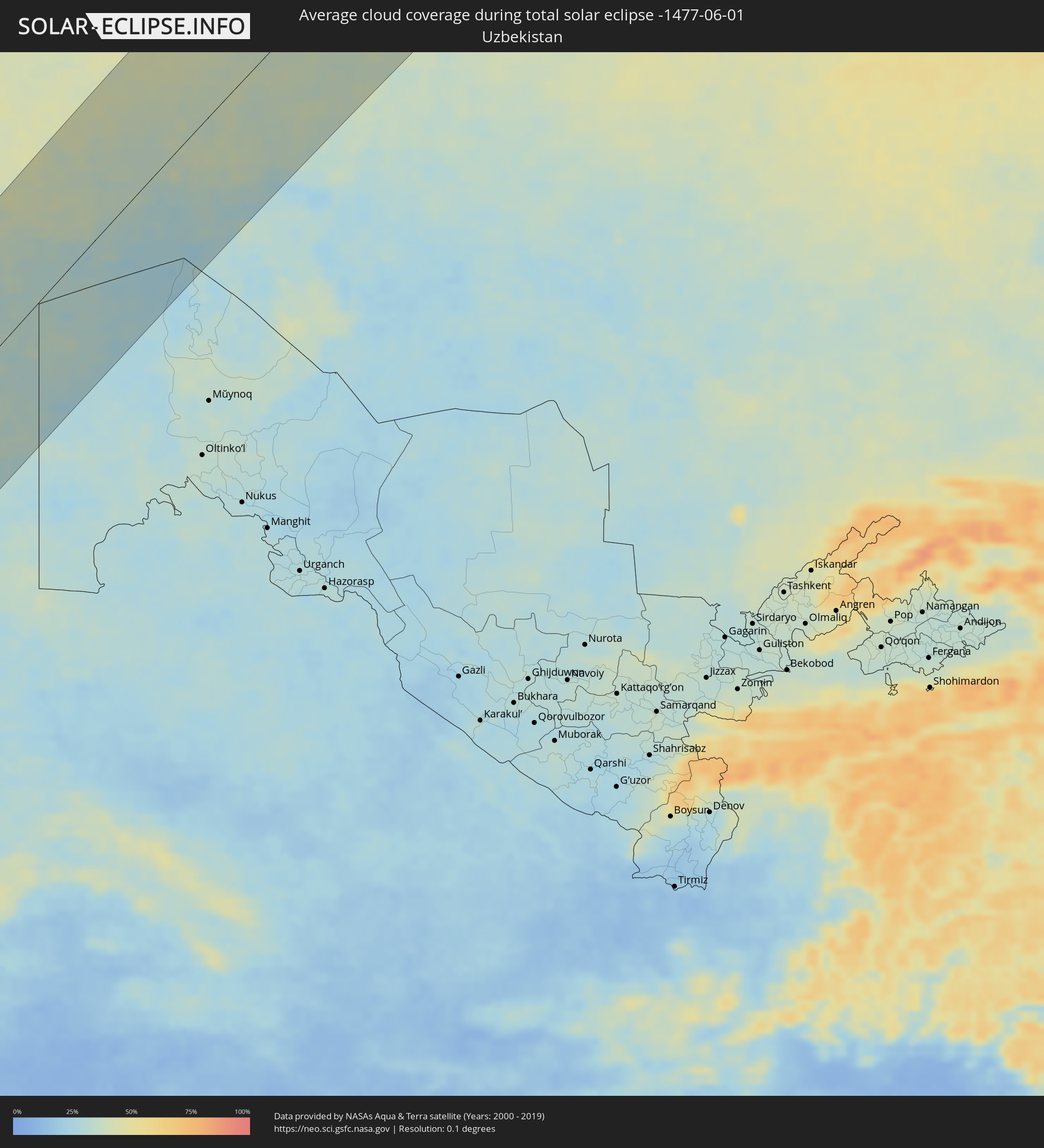
The following maps show the average cloud coverage for the day of the total solar eclipse.
With the help of these maps, it is possible to find the place along the eclipse path, which has the best
chance of a cloudless sky.
Nevertheless, you should consider local circumstances and inform about the weather of your chosen
observation site.
The data is provided by NASAs satellites
AQUA and TERRA.
The cloud maps are averaged over a period of 19 years (2000 - 2019).
Detailed country maps
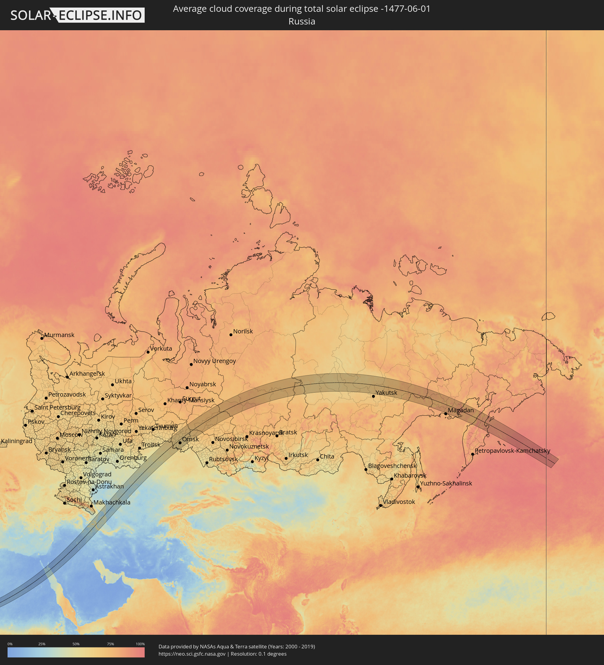 Russia
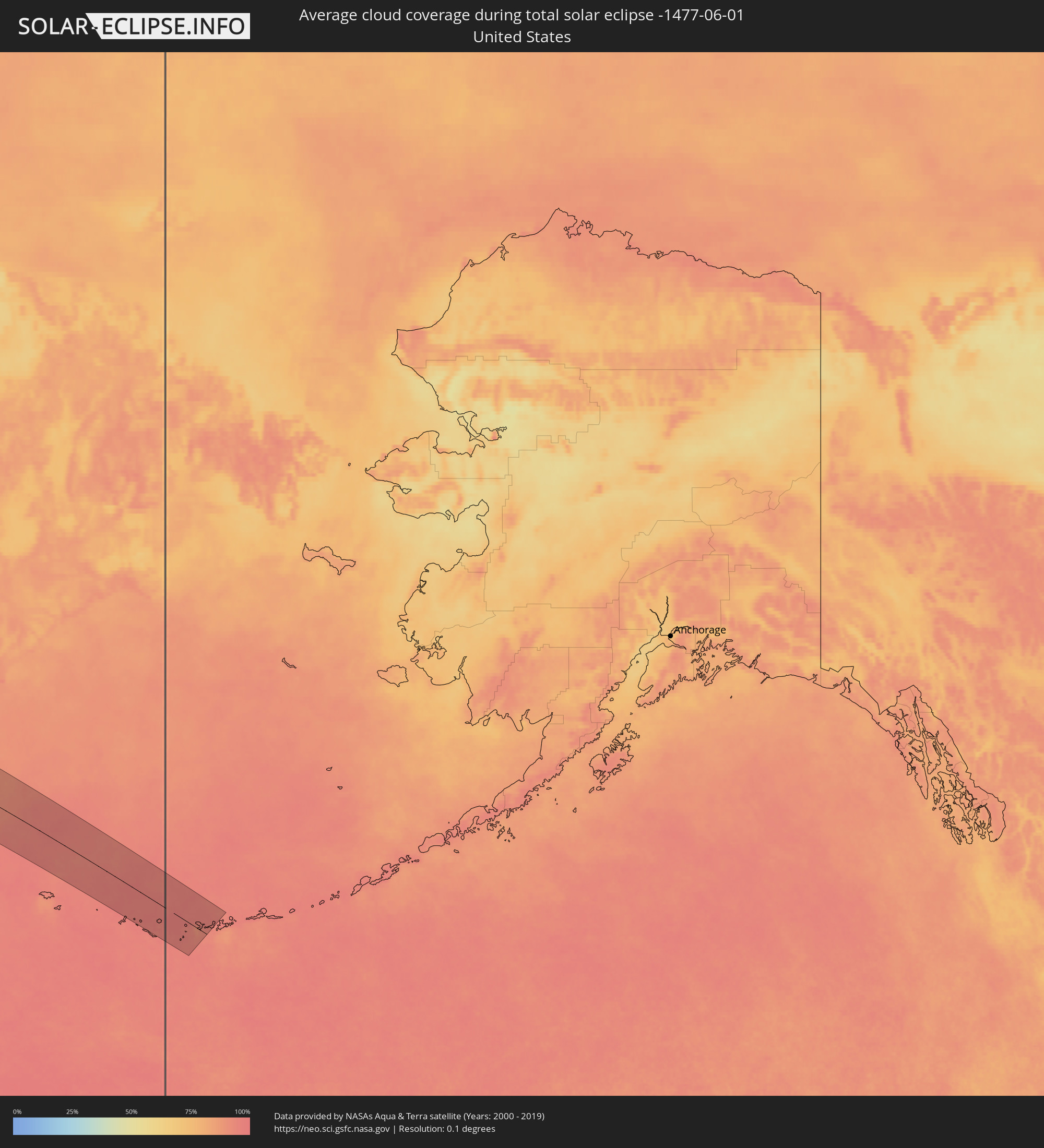 United States
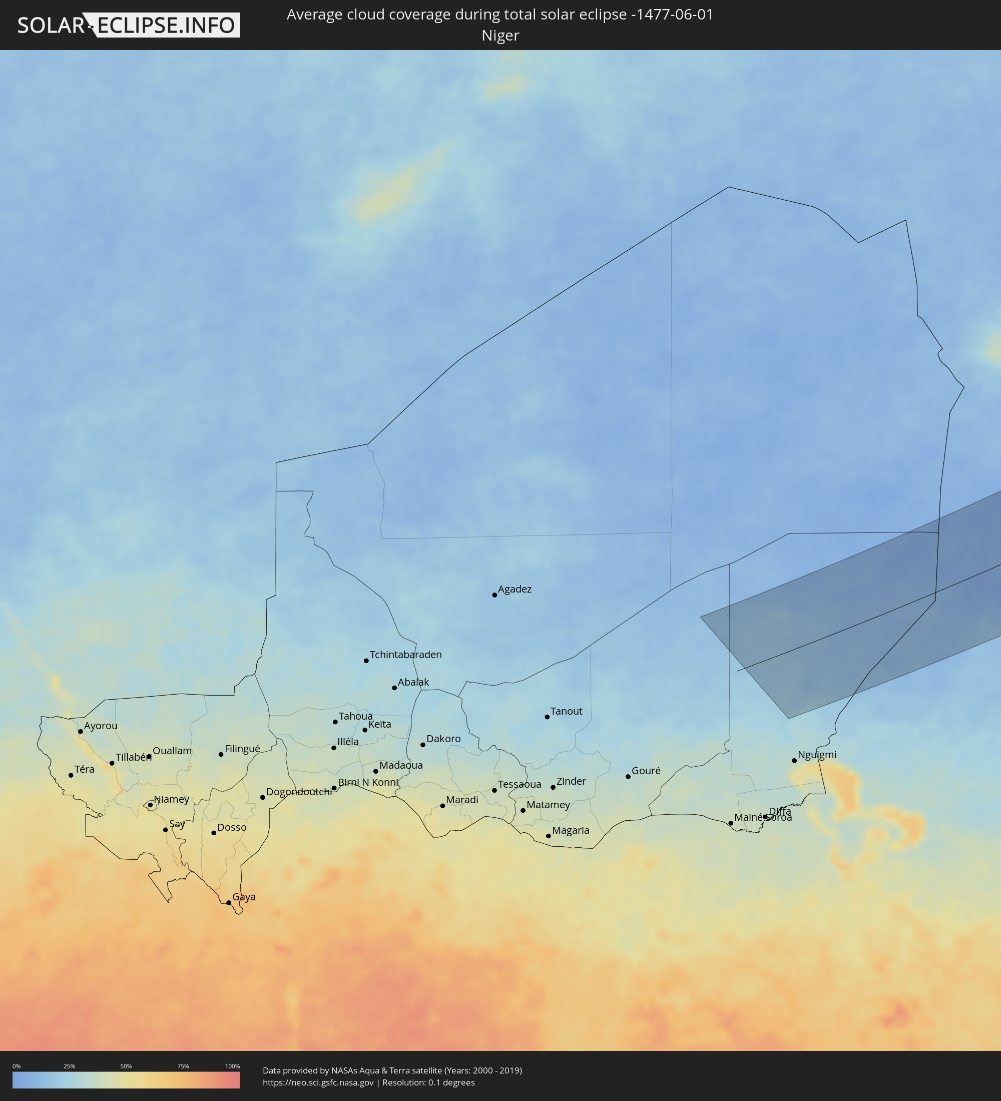 Niger
Niger
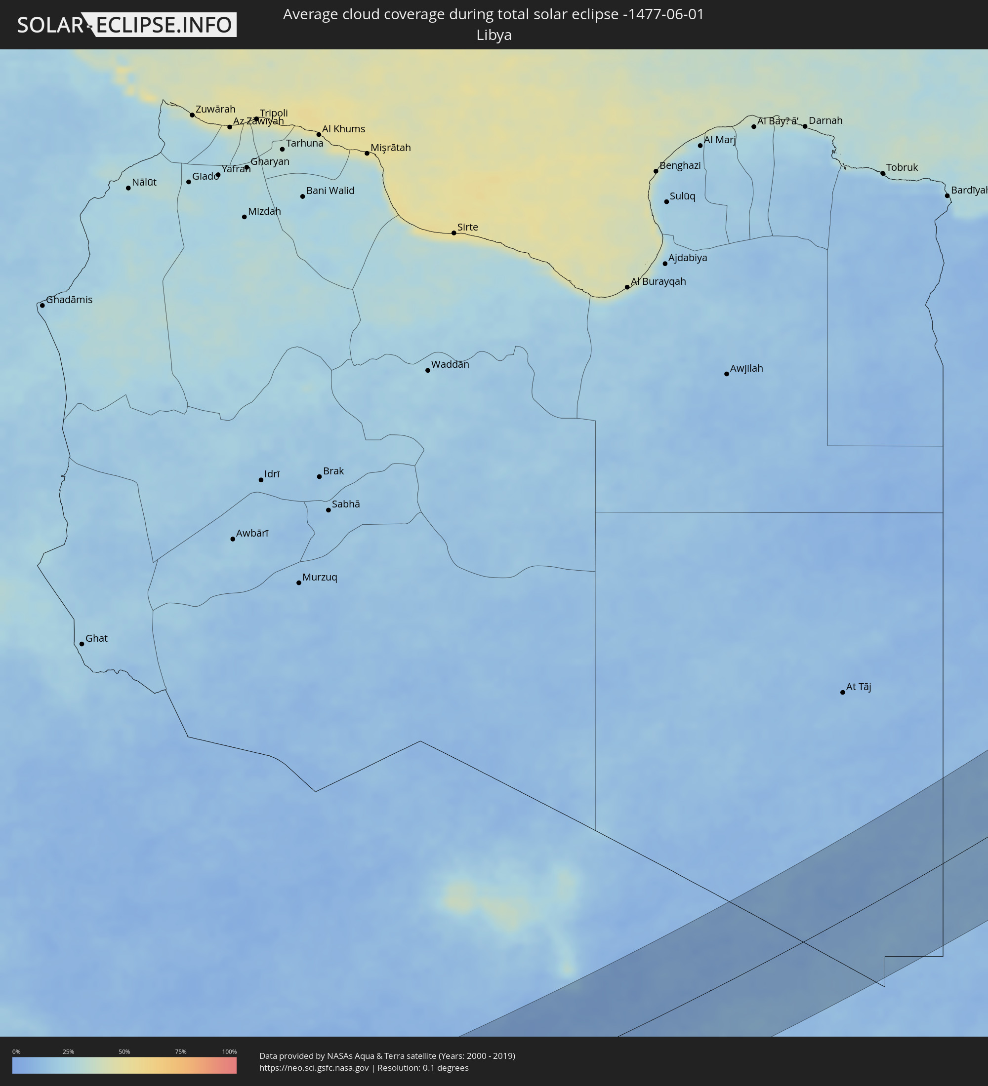 Libya
Libya
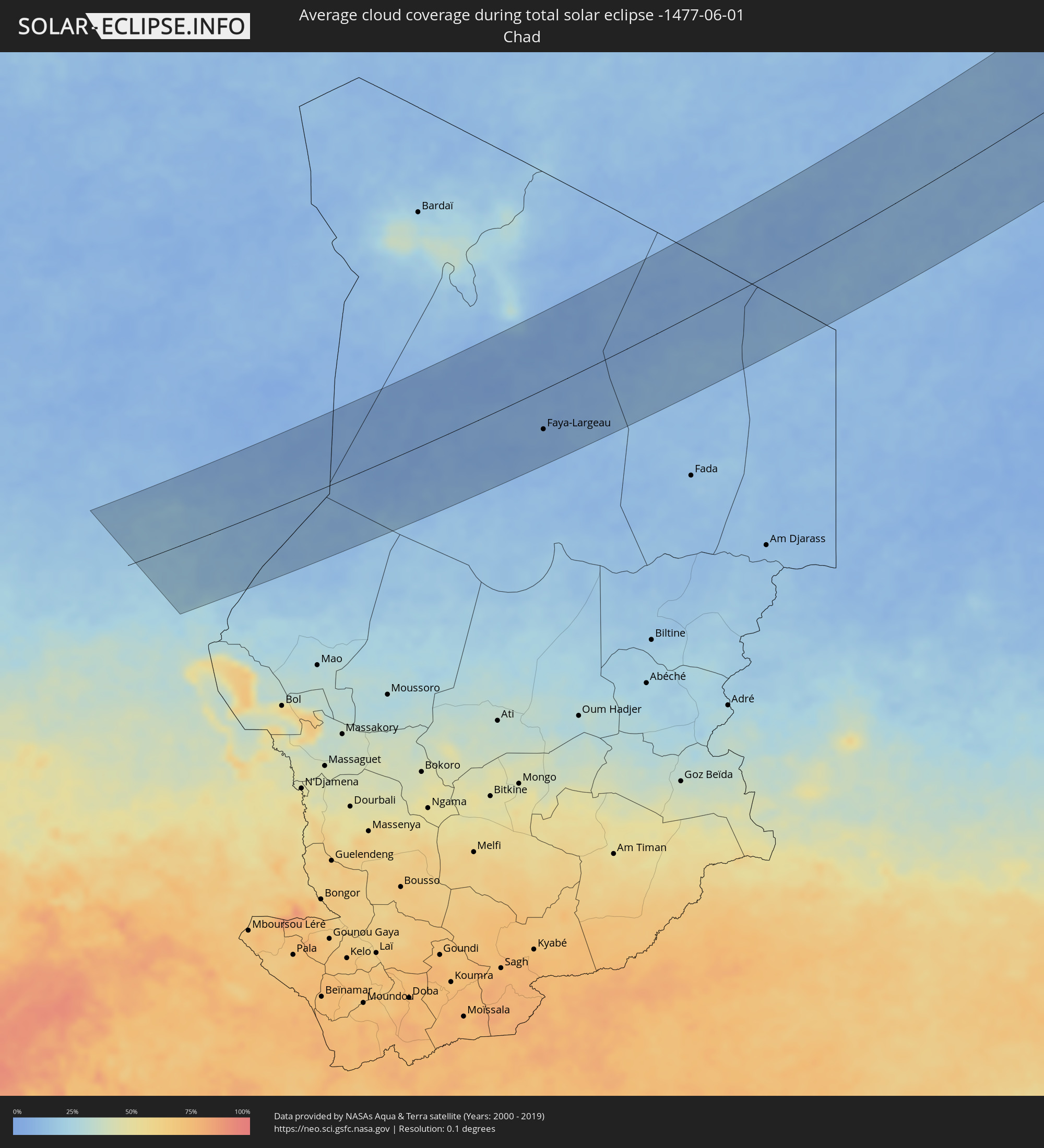 Chad
Chad
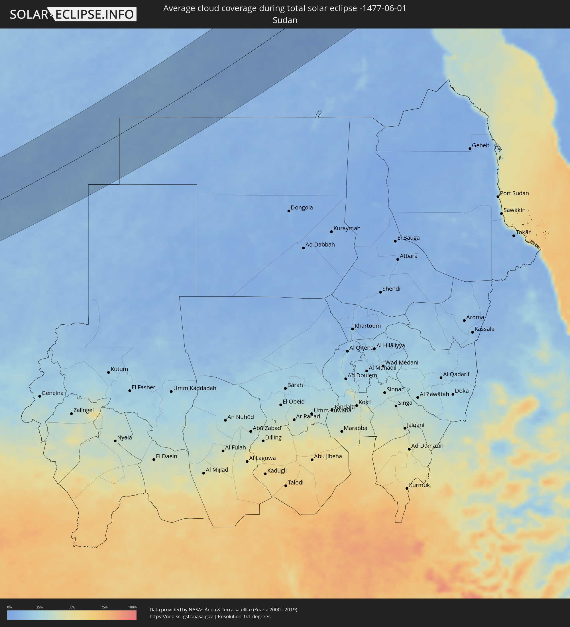 Sudan
Sudan
 Egypt
Egypt
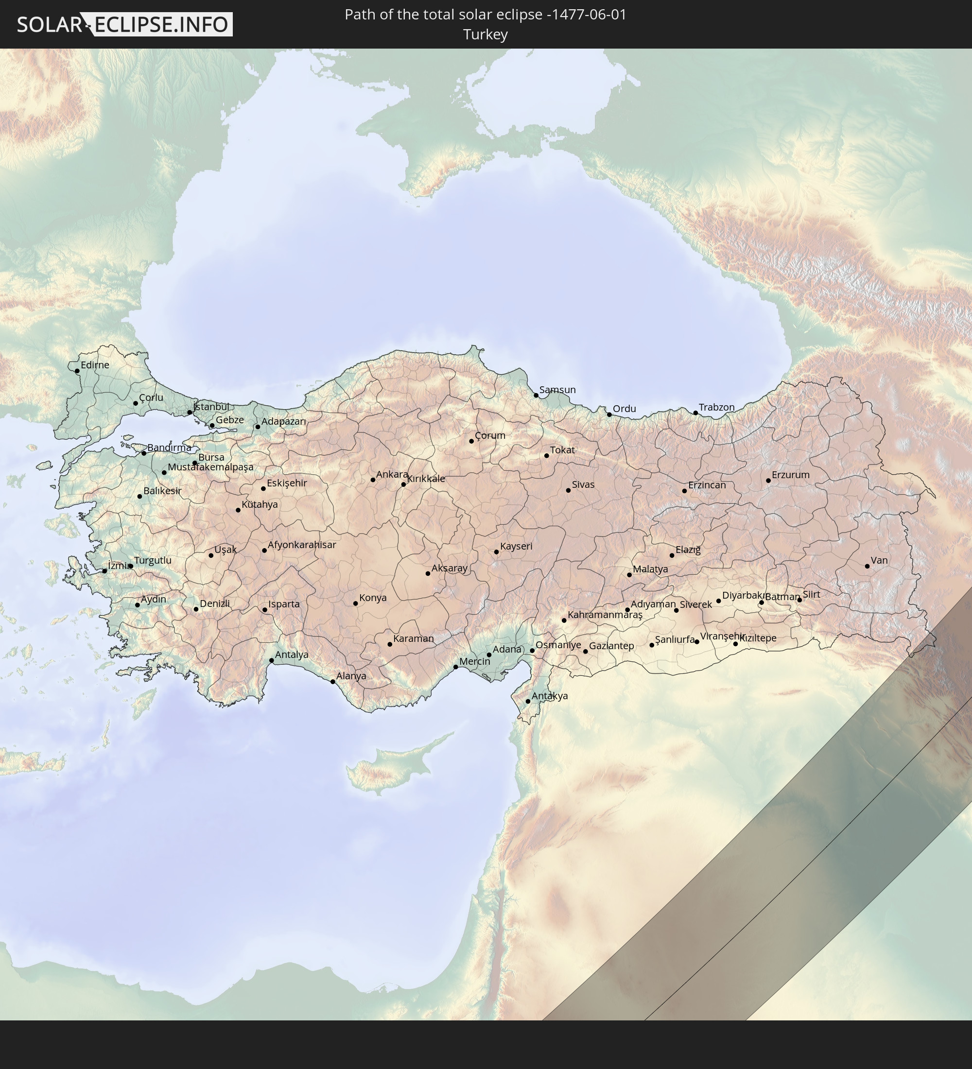
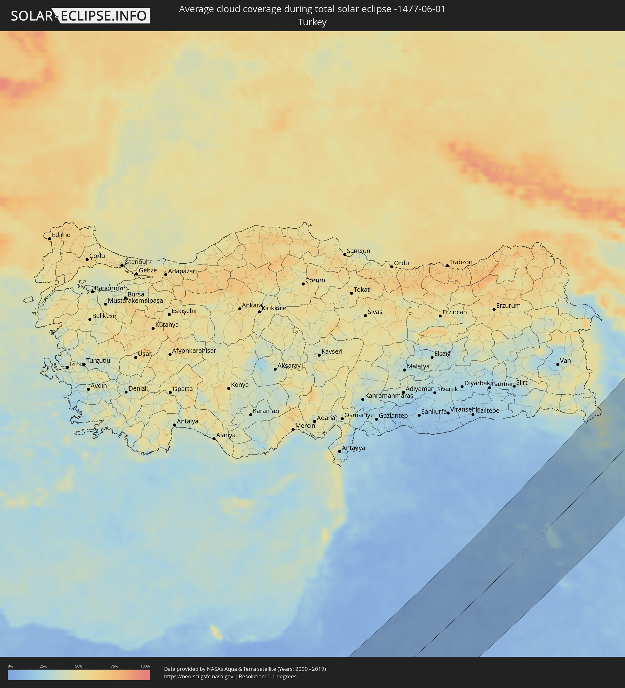 Turkey
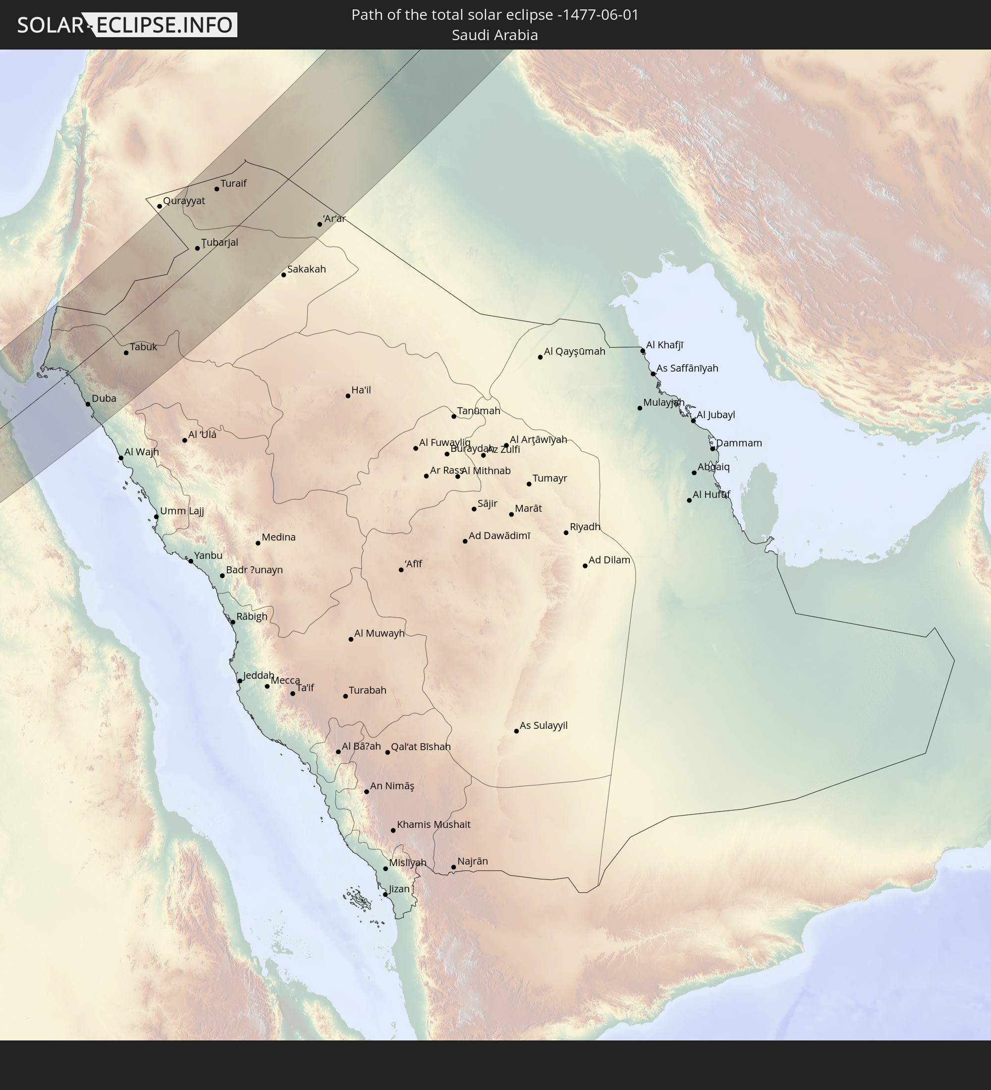
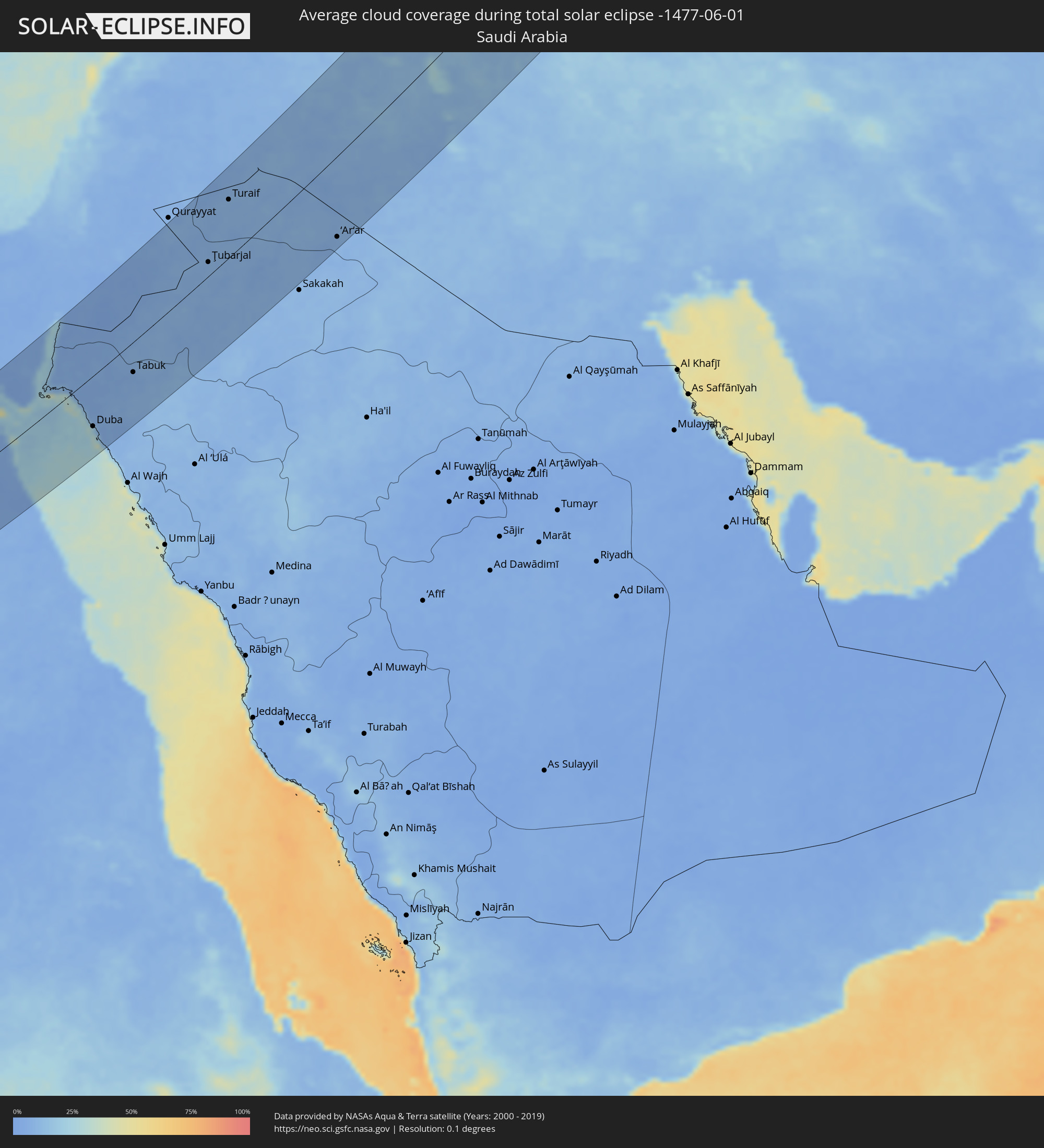 Saudi Arabia
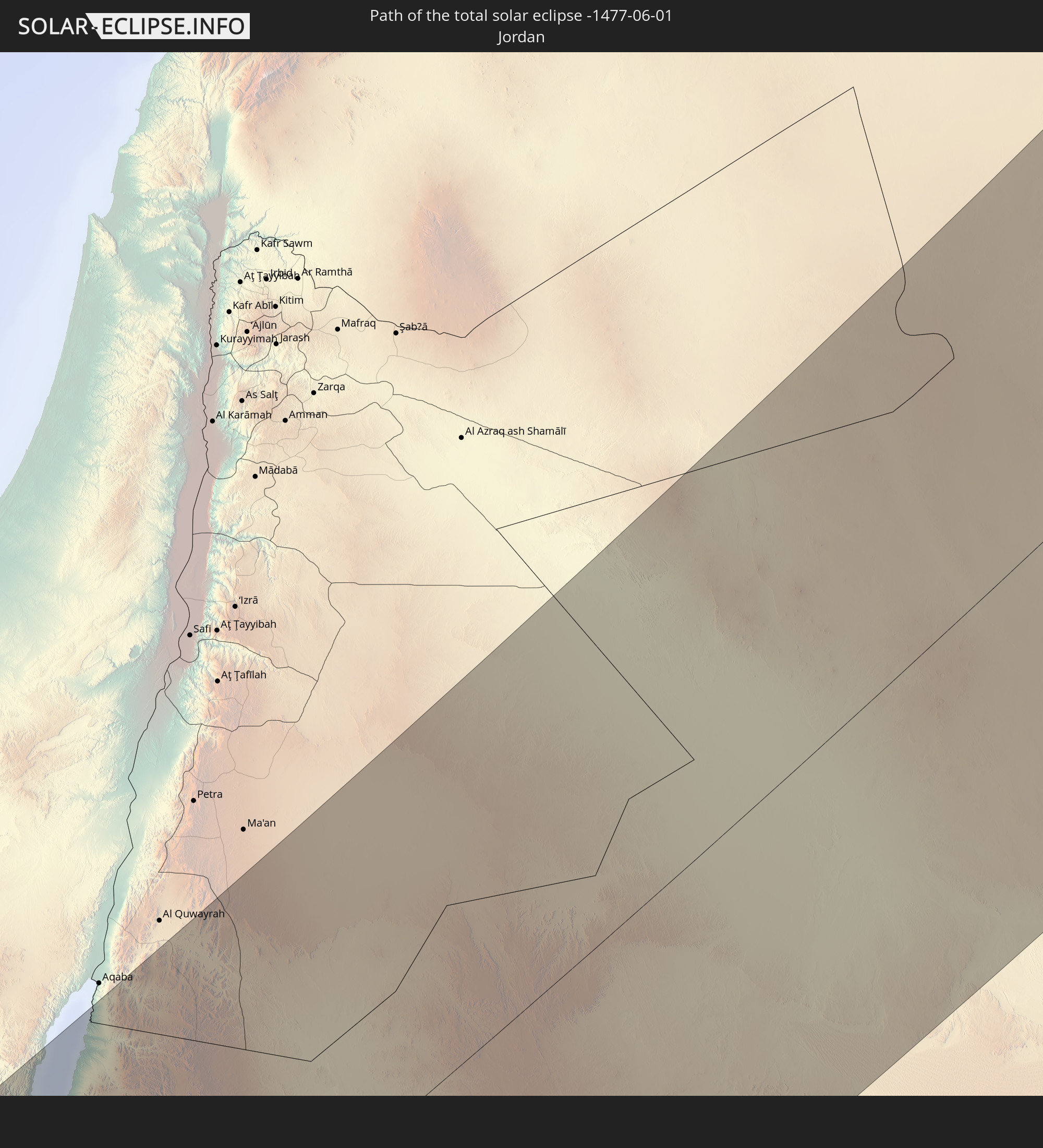
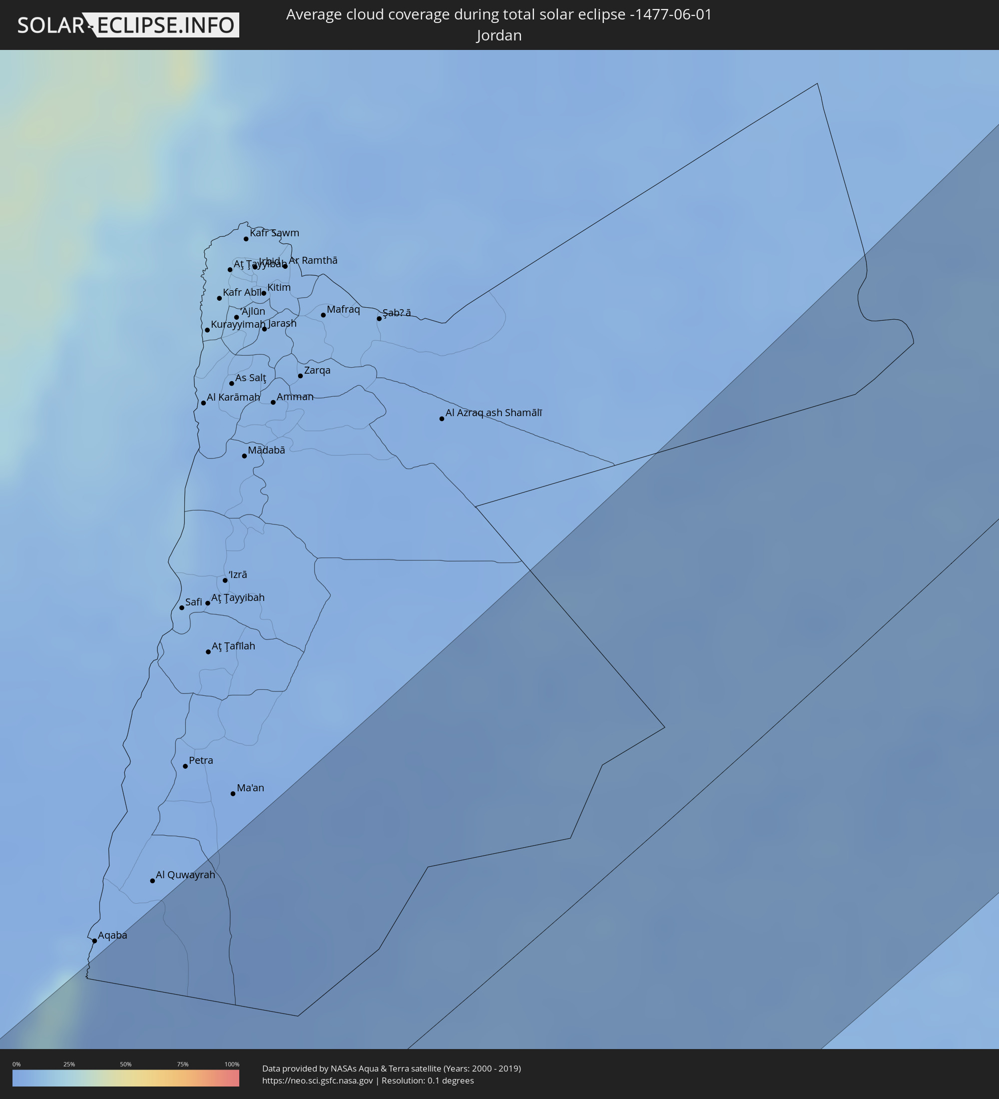 Jordan
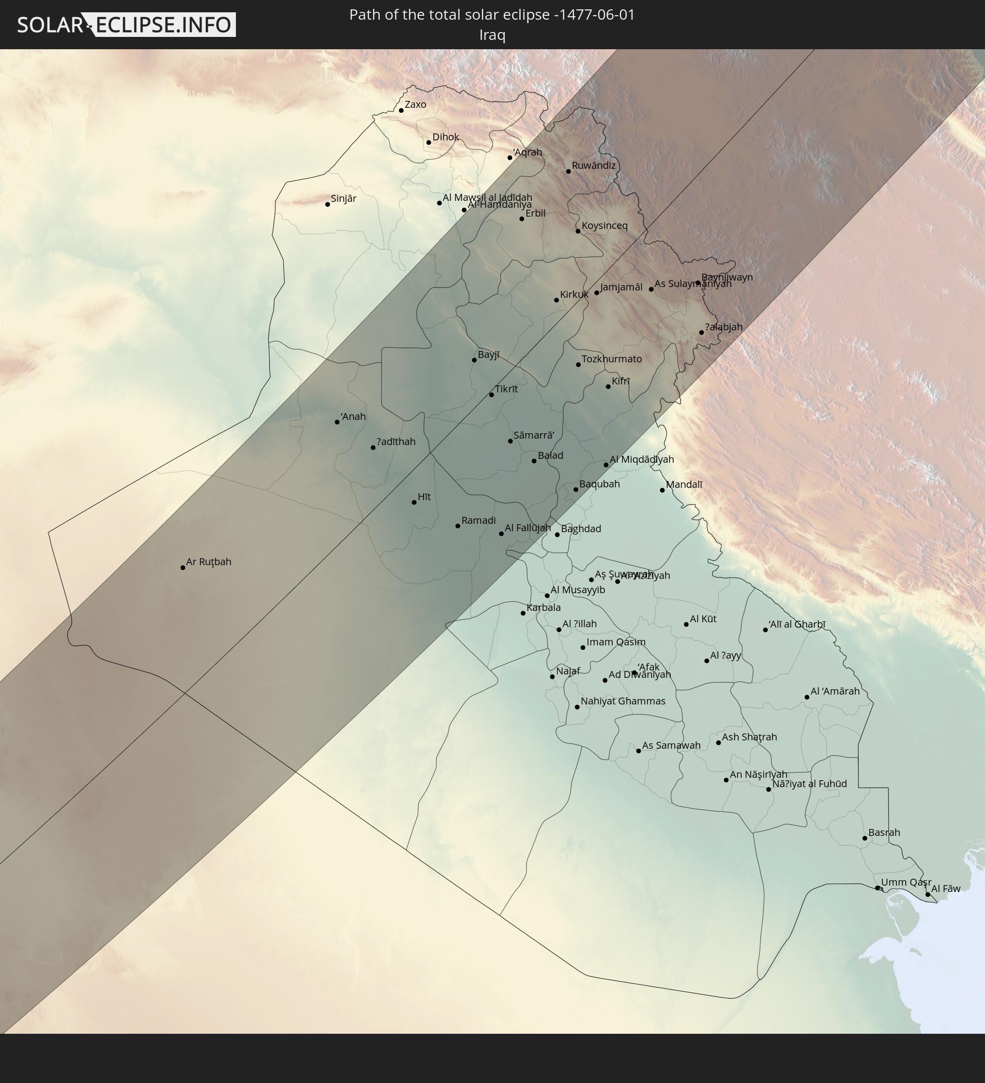
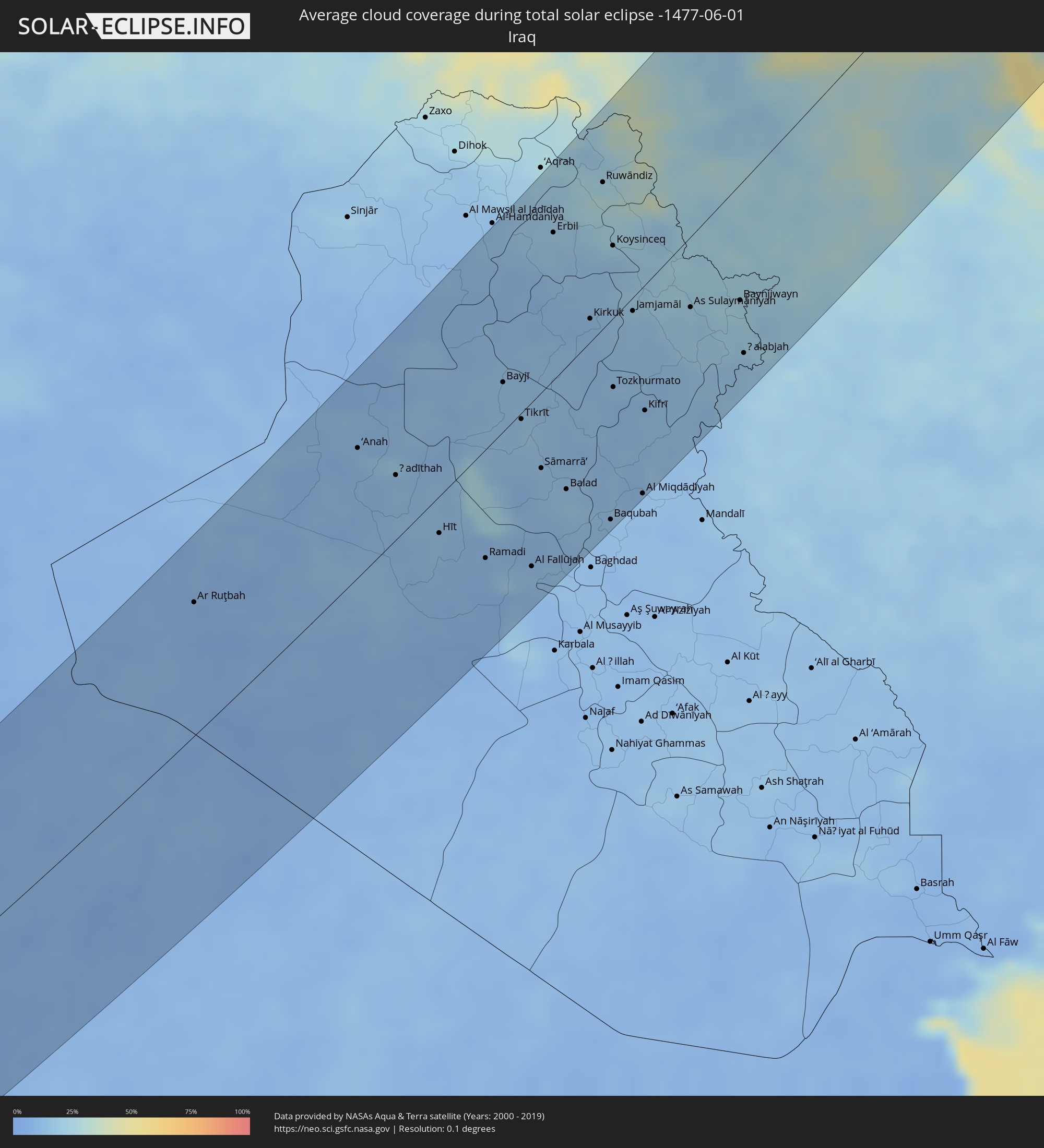 Iraq
Iraq
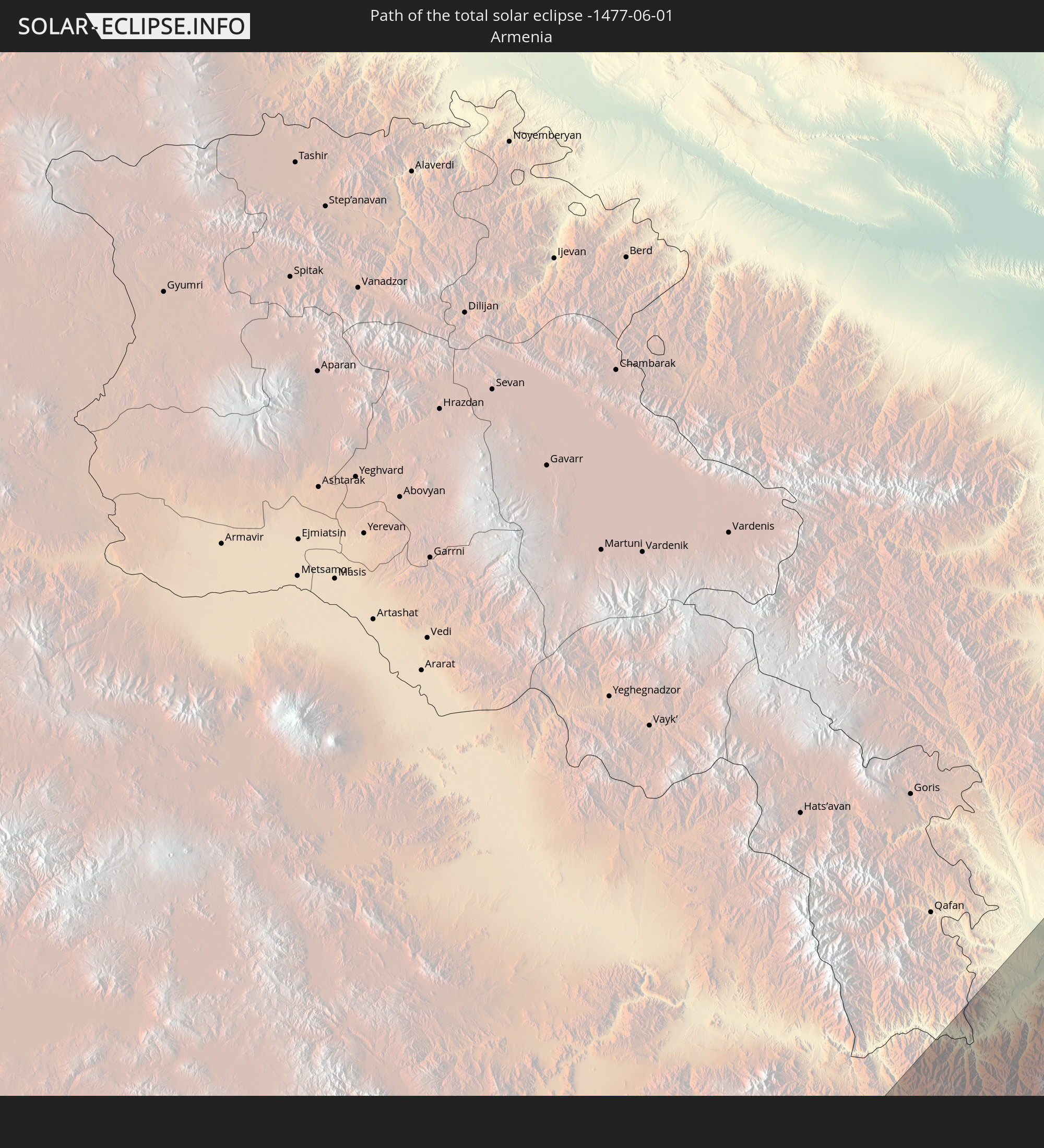
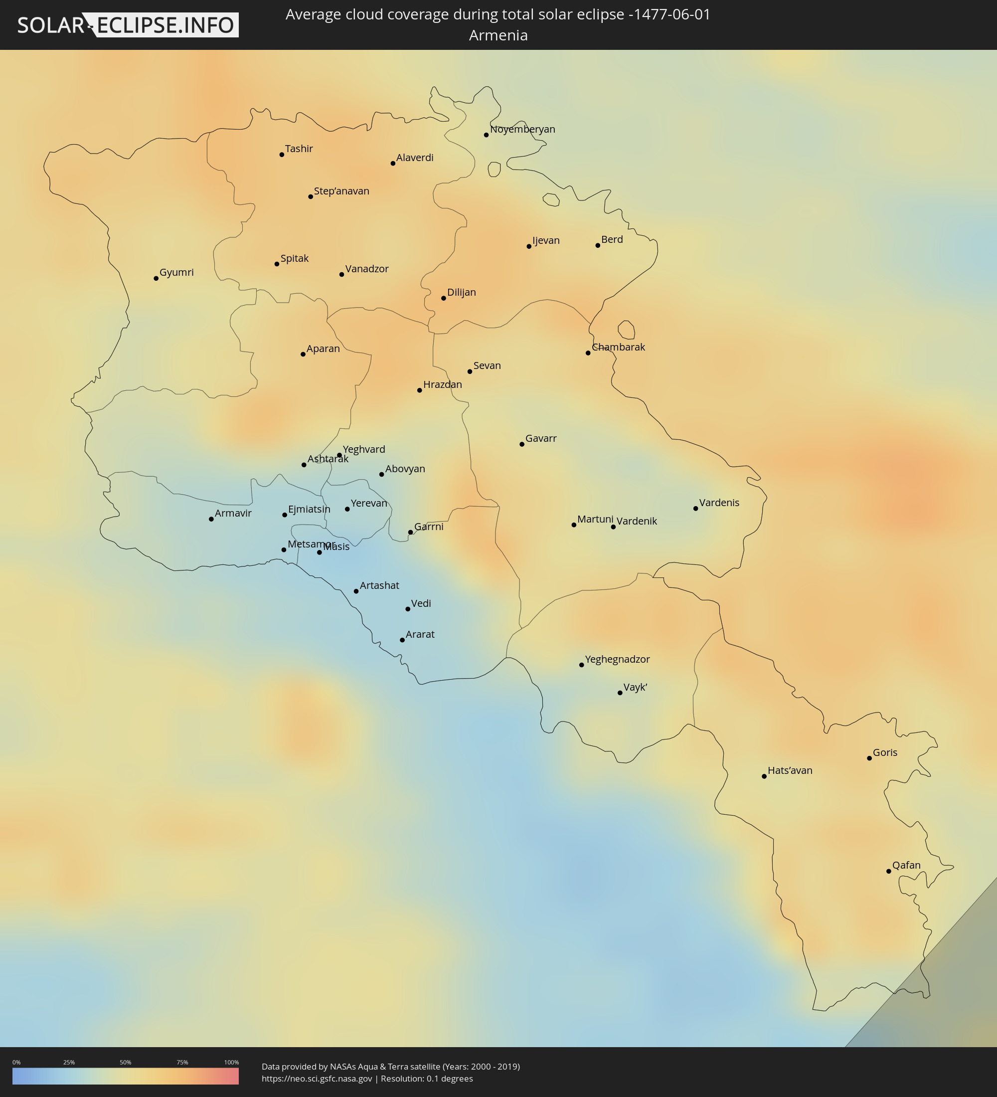 Armenia
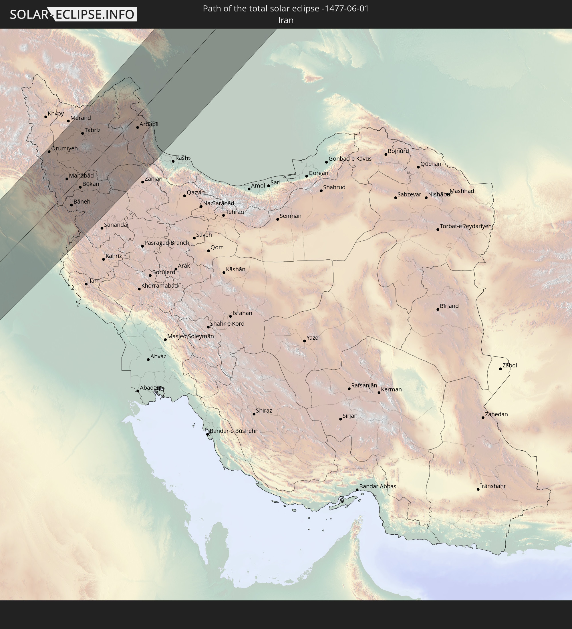
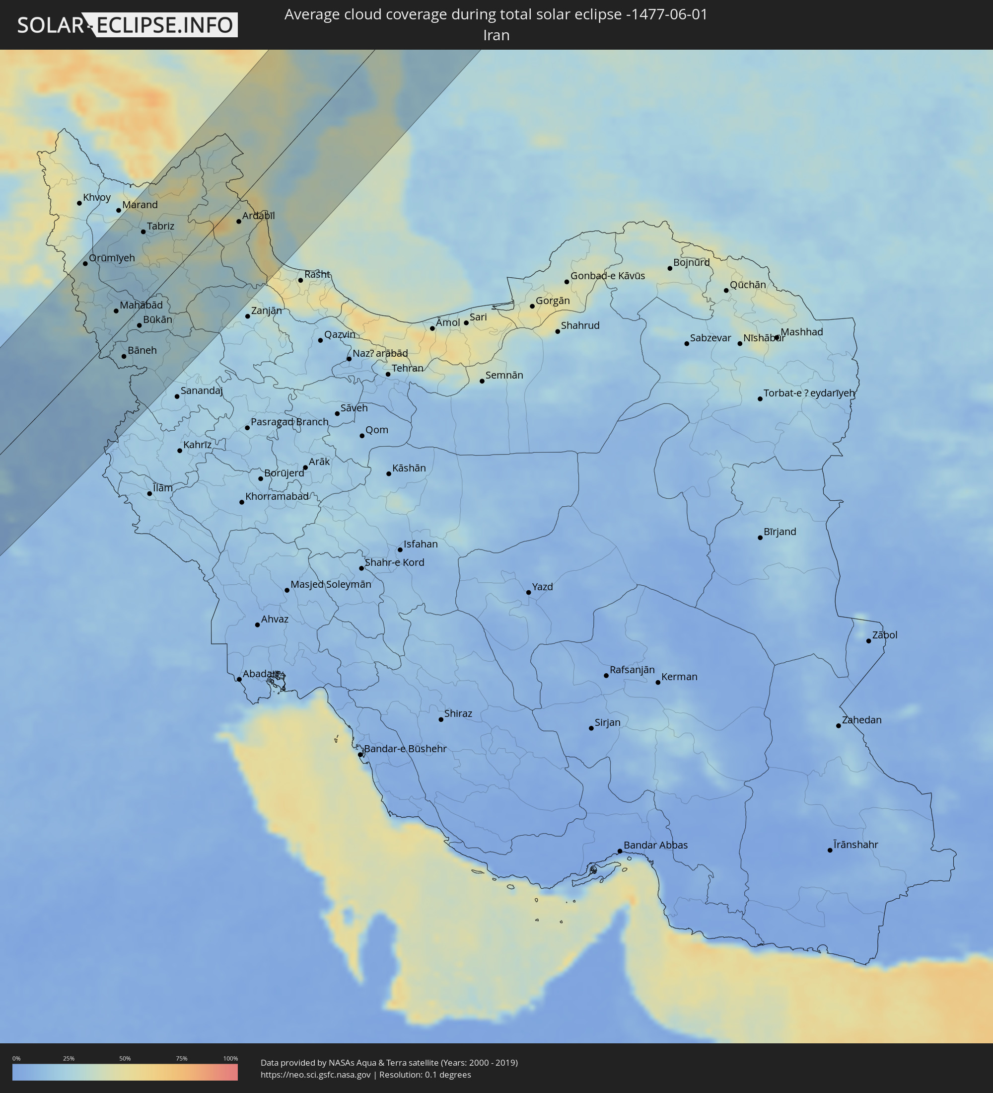 Iran
Iran
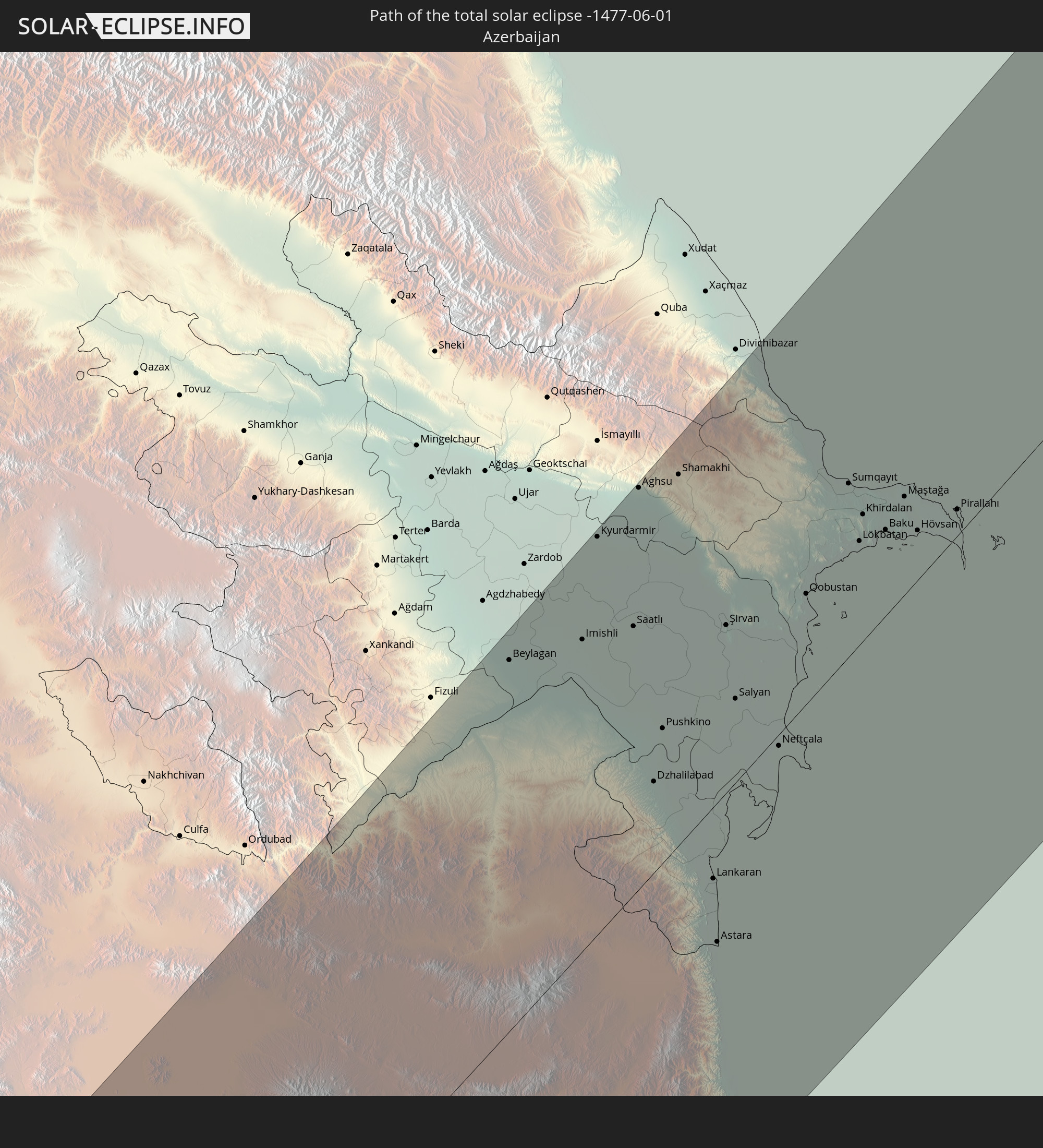
 Azerbaijan
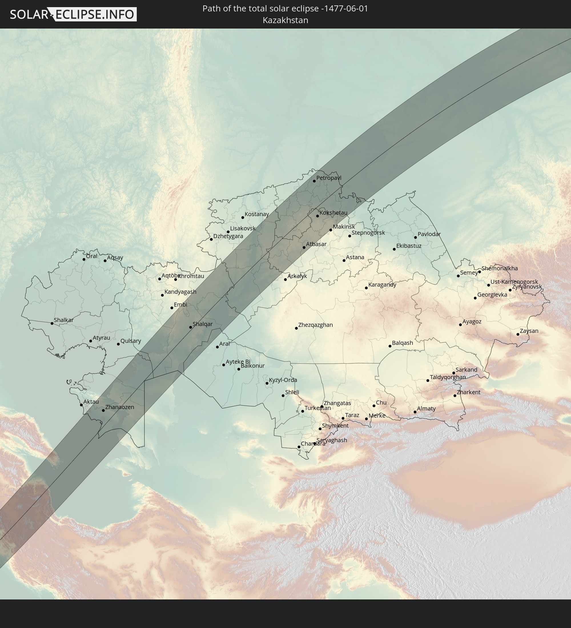
 Kazakhstan
 Turkmenistan
 Uzbekistan
Cities inside the path of the eclipse
The following table shows all locations with a population of more than 5,000 inside the eclipse path. Cities which have more than 100,000 inhabitants are marked bold. A click at the locations opens a detailed map.
| City | Type | Eclipse duration | Local time of max. eclipse | Distance to central line | Ø Cloud coverage |
|
Faya-Largeau, Borkou
|
total | - | 05:38:51 UTC+01:00 | 66 km | 8% |
|
Al Khārijah, New Valley
|
total | - | 06:48:08 UTC+02:00 | 62 km | 6% |
|
Juhaynah, Sohag
|
total | - | 06:50:08 UTC+02:00 | 116 km | 5% |
|
Ţahţā, Sohag
|
total | - | 06:50:17 UTC+02:00 | 125 km | 6% |
|
Sohag, Sohag
|
total | - | 06:49:59 UTC+02:00 | 96 km | 4% |
|
Akhmīm, Sohag
|
total | - | 06:50:00 UTC+02:00 | 89 km | 4% |
|
Al Manshāh, Sohag
|
total | - | 06:49:52 UTC+02:00 | 78 km | 4% |
|
Jirjā, Sohag
|
total | - | 06:49:41 UTC+02:00 | 60 km | 3% |
|
Al Balyanā, Sohag
|
total | - | 06:49:32 UTC+02:00 | 44 km | 4% |
|
Farshūţ, Qena
|
total | - | 06:49:17 UTC+02:00 | 18 km | 6% |
|
Naj‘ Ḩammādī, Qena
|
total | - | 06:49:17 UTC+02:00 | 13 km | 6% |
|
Dishnā, Qena
|
total | - | 06:49:27 UTC+02:00 | 6 km | 6% |
|
Isnā, Qena
|
total | - | 06:48:11 UTC+02:00 | 75 km | 6% |
|
Luxor, Luxor
|
total | - | 06:48:49 UTC+02:00 | 42 km | 8% |
|
Qinā, Qena
|
total | - | 06:49:33 UTC+02:00 | 6 km | 6% |
|
Kousa, Qena
|
total | - | 06:49:10 UTC+02:00 | 30 km | 7% |
|
Idfū, Aswan
|
total | - | 06:47:46 UTC+02:00 | 122 km | 7% |
|
El-Tor, South Sinai
|
total | - | 06:53:00 UTC+02:00 | 122 km | 23% |
|
El Gouna, Red Sea
|
total | - | 06:51:40 UTC+02:00 | 45 km | 14% |
|
Hurghada, Red Sea
|
total | - | 06:51:29 UTC+02:00 | 25 km | 15% |
|
Būr Safājah, Red Sea
|
total | - | 06:50:41 UTC+02:00 | 43 km | 8% |
|
Al Quşayr, Red Sea
|
total | - | 06:49:46 UTC+02:00 | 105 km | 15% |
|
Sharm el-Sheikh, South Sinai
|
total | - | 06:52:39 UTC+02:00 | 53 km | 22% |
|
Dhahab, South Sinai
|
total | - | 06:53:38 UTC+02:00 | 89 km | 24% |
|
Duba, Tabuk
|
total | - | 07:58:58 UTC+03:06 | 86 km | 21% |
|
Tabuk, Tabuk
|
total | - | 08:00:56 UTC+03:06 | 58 km | 6% |
|
Ţubarjal, Al Jawf
|
total | - | 08:05:00 UTC+03:06 | 28 km | 8% |
|
Turaif, Northern Borders
|
total | - | 08:07:10 UTC+03:06 | 93 km | 9% |
|
Ar Ruţbah, Anbar
|
total | - | 08:00:59 UTC+02:57 | 94 km | 9% |
|
‘Ar‘ar, Northern Borders
|
total | - | 08:06:59 UTC+03:06 | 123 km | 8% |
|
‘Anat al Qadīmah, Anbar
|
total | - | 08:04:20 UTC+02:57 | 102 km | 11% |
|
‘Anah, Anbar
|
total | - | 08:04:10 UTC+02:57 | 90 km | 14% |
|
Ḩadīthah, Anbar
|
total | - | 08:03:58 UTC+02:57 | 52 km | 13% |
|
Hīt, Anbar
|
total | - | 08:03:18 UTC+02:57 | 31 km | 13% |
|
Ramadi, Anbar
|
total | - | 08:03:11 UTC+02:57 | 80 km | 11% |
|
Bayjī, Salah ad Din Governorate
|
total | - | 08:06:00 UTC+02:57 | 46 km | 15% |
|
Tikrīt, Salah ad Din Governorate
|
total | - | 08:05:32 UTC+02:57 | 20 km | 17% |
|
Al Fallūjah, Anbar
|
total | - | 08:03:19 UTC+02:57 | 111 km | 13% |
|
Sāmarrā’, Salah ad Din Governorate
|
total | - | 08:04:54 UTC+02:57 | 50 km | 14% |
|
Erbil, Arbīl
|
total | - | 08:08:36 UTC+02:57 | 100 km | 17% |
|
Balad, Salah ad Din Governorate
|
total | - | 08:04:43 UTC+02:57 | 82 km | 17% |
|
Ad Dujayl, Salah ad Din Governorate
|
total | - | 08:04:28 UTC+02:57 | 101 km | 13% |
|
Kirkuk, At Taʼmīm
|
total | - | 08:07:30 UTC+02:57 | 15 km | 12% |
|
Ruwāndiz, Arbīl
|
total | - | 08:09:40 UTC+02:57 | 98 km | 29% |
|
Khāliş, Diyālá
|
total | - | 08:04:34 UTC+02:57 | 124 km | 12% |
|
Baqubah, Diyālá
|
total | - | 08:04:31 UTC+02:57 | 133 km | 12% |
|
Koysinceq, Arbīl
|
total | - | 08:08:46 UTC+02:57 | 47 km | 18% |
|
Tozkhurmato, Salah ad Din Governorate
|
total | - | 08:06:35 UTC+02:57 | 54 km | 11% |
|
Jamjamāl, As Sulaymānīyah
|
total | - | 08:07:53 UTC+02:57 | 32 km | 16% |
|
Al Miqdādīyah, Diyālá
|
total | - | 08:05:07 UTC+02:57 | 137 km | 13% |
|
Kifrī, Diyālá
|
total | - | 08:06:25 UTC+02:57 | 86 km | 13% |
|
Orūmīyeh, Āz̄ārbāyjān-e Gharbī
|
total | - | 08:39:52 UTC+03:25 | 130 km | 27% |
|
Oshnavīyeh, Āz̄ārbāyjān-e Gharbī
|
total | - | 08:38:57 UTC+03:25 | 92 km | 31% |
|
Piranshahr, Āz̄ārbāyjān-e Gharbī
|
total | - | 08:38:21 UTC+03:25 | 63 km | 29% |
|
Naqadeh, Āz̄ārbāyjān-e Gharbī
|
total | - | 08:38:58 UTC+03:25 | 65 km | 25% |
|
As Sulaymānīyah, As Sulaymānīyah
|
total | - | 08:08:19 UTC+02:57 | 46 km | 21% |
|
Mahābād, Āz̄ārbāyjān-e Gharbī
|
total | - | 08:38:50 UTC+03:25 | 28 km | 28% |
|
Bāneh, Kordestān
|
total | - | 08:37:32 UTC+03:25 | 42 km | 25% |
|
‘Ajab Shīr, East Azerbaijan
|
total | - | 08:40:16 UTC+03:25 | 70 km | 20% |
|
Baynjiwayn, As Sulaymānīyah
|
total | - | 08:08:45 UTC+02:57 | 77 km | 23% |
|
Ḩalabjah, As Sulaymānīyah
|
total | - | 08:07:57 UTC+02:57 | 112 km | 16% |
|
Bonāb, East Azerbaijan
|
total | - | 08:40:07 UTC+03:25 | 49 km | 17% |
|
Mīāndoāb, Āz̄ārbāyjān-e Gharbī
|
total | - | 08:39:27 UTC+03:25 | 37 km | 22% |
|
Būkān, Āz̄ārbāyjān-e Gharbī
|
total | - | 08:38:42 UTC+03:25 | 23 km | 23% |
|
Saqqez, Kordestān
|
total | - | 08:38:15 UTC+03:25 | 50 km | 27% |
|
Tabriz, East Azerbaijan
|
total | - | 08:41:38 UTC+03:25 | 90 km | 27% |
|
Shāhīn Dezh, Āz̄ārbāyjān-e Gharbī
|
total | - | 08:39:14 UTC+03:25 | 44 km | 25% |
|
Hashtrūd, East Azerbaijan
|
total | - | 08:41:02 UTC+03:25 | 5 km | 28% |
|
Ahar, East Azerbaijan
|
total | - | 08:42:54 UTC+03:25 | 72 km | 36% |
|
Takāb, Āz̄ārbāyjān-e Gharbī
|
total | - | 08:39:05 UTC+03:25 | 93 km | 26% |
|
Beylagan, Beyləqan
|
total | - | 08:39:22 UTC+03:19 | 134 km | 42% |
|
Pārsābād, Ardabīl
|
total | - | 08:45:41 UTC+03:25 | 105 km | 33% |
|
Imishli, İmişli
|
total | - | 08:39:52 UTC+03:19 | 109 km | 38% |
|
Kyurdarmir, Kürdǝmir
|
total | - | 08:40:49 UTC+03:19 | 139 km | 39% |
|
Ardabīl, Ardabīl
|
total | - | 08:43:21 UTC+03:25 | 28 km | 36% |
|
Saatlı, Saatlı
|
total | - | 08:40:12 UTC+03:19 | 96 km | 37% |
|
Aghsu, Ağsu
|
total | - | 08:41:25 UTC+03:19 | 139 km | 43% |
|
Dzhalilabad, Jalilabad
|
total | - | 08:38:57 UTC+03:19 | 44 km | 40% |
|
Khalkhāl, Ardabīl
|
total | - | 08:42:20 UTC+03:25 | 94 km | 32% |
|
Pushkino, Bilǝsuvar
|
total | - | 08:39:27 UTC+03:19 | 47 km | 38% |
|
Prishibinskoye, Jalilabad
|
total | - | 08:38:51 UTC+03:19 | 37 km | 39% |
|
Shamakhi, Şamaxı
|
total | - | 08:41:43 UTC+03:19 | 127 km | 42% |
|
Lankaran, Lənkəran
|
total | - | 08:38:22 UTC+03:19 | 31 km | 33% |
|
Āstārā, Gīlān
|
total | - | 08:44:06 UTC+03:25 | 52 km | 38% |
|
Astara, Astara
|
total | - | 08:37:50 UTC+03:19 | 49 km | 36% |
|
Hashtpar, Gīlān
|
total | - | 08:42:57 UTC+03:25 | 101 km | 46% |
|
Şirvan, Shirvan
|
total | - | 08:40:38 UTC+03:19 | 59 km | 42% |
|
Salyan, Salyan
|
total | - | 08:40:02 UTC+03:19 | 42 km | 40% |
|
Neftçala, Neftçala
|
total | - | 08:39:50 UTC+03:19 | 28 km | 32% |
|
Qobustan, Baki
|
total | - | 08:41:16 UTC+03:19 | 49 km | 34% |
|
Sumqayıt, Sumqayit
|
total | - | 08:42:25 UTC+03:19 | 59 km | 37% |
|
Saray, Abşeron
|
total | - | 08:42:21 UTC+03:19 | 52 km | 36% |
|
Badamdar, Baki
|
total | - | 08:42:03 UTC+03:19 | 32 km | 28% |
|
Baku, Baki
|
total | - | 08:42:12 UTC+03:19 | 29 km | 29% |
|
Balakhani, Baki
|
total | - | 08:42:23 UTC+03:19 | 34 km | 33% |
|
Maştağa, Baki
|
total | - | 08:42:34 UTC+03:19 | 42 km | 33% |
|
Hövsan, Baki
|
total | - | 08:42:20 UTC+03:19 | 17 km | 28% |
|
Türkan, Baki
|
total | - | 08:42:26 UTC+03:19 | 28 km | 28% |
|
Zyrya, Baki
|
total | - | 08:42:29 UTC+03:19 | 23 km | 26% |
|
Pirallahı, Baki
|
total | - | 08:42:42 UTC+03:19 | 15 km | 26% |
|
Yeraliyev, Mangghystaū
|
total | - | 08:54:52 UTC+03:25 | 126 km | 28% |
|
Zhetibay, Mangghystaū
|
total | - | 08:55:58 UTC+03:25 | 132 km | 30% |
|
Zhanaozen, Mangghystaū
|
total | - | 08:56:10 UTC+03:25 | 64 km | 29% |
|
Beyneu, Mangghystaū
|
total | - | 09:01:54 UTC+03:25 | 71 km | 28% |
|
Shalqar, Aqtöbe
|
total | - | 09:10:40 UTC+03:25 | 22 km | 39% |
|
Sekseūil, Qyzylorda
|
total | - | 10:07:27 UTC+04:21 | 133 km | 34% |
|
Torghay, Qostanay
|
total | - | 10:14:16 UTC+04:21 | 57 km | 45% |
|
Qusmuryn, Qostanay
|
total | - | 10:19:57 UTC+04:21 | 114 km | 51% |
|
Derzhavīnsk, Aqmola
|
total | - | 10:19:42 UTC+04:21 | 78 km | 48% |
|
Esil, Aqmola
|
total | - | 10:21:07 UTC+04:21 | 24 km | 53% |
|
Novoishimskiy, Soltüstik Qazaqstan
|
total | - | 10:23:21 UTC+04:21 | 72 km | 53% |
|
Zhaqsy, Aqmola
|
total | - | 10:22:03 UTC+04:21 | 63 km | 53% |
|
Sergeyevka, Soltüstik Qazaqstan
|
total | - | 10:25:02 UTC+04:21 | 99 km | 56% |
|
Shantobe, Aqmola
|
total | - | 10:23:49 UTC+04:21 | 55 km | 54% |
|
Atbasar, Aqmola
|
total | - | 10:23:05 UTC+04:21 | 117 km | 55% |
|
Balkashino, Aqmola
|
total | - | 10:24:34 UTC+04:21 | 74 km | 55% |
|
Bishkul, Soltüstik Qazaqstan
|
total | - | 10:28:05 UTC+04:21 | 100 km | 60% |
|
Petropavl, Soltüstik Qazaqstan
|
total | - | 10:28:16 UTC+04:21 | 106 km | 63% |
|
Kokshetau, Aqmola
|
total | - | 10:26:22 UTC+04:21 | 39 km | 58% |
|
Smirnovo, Soltüstik Qazaqstan
|
total | - | 10:28:05 UTC+04:21 | 64 km | 58% |
|
Akkol’, Aqmola
|
total | - | 10:26:37 UTC+04:21 | 48 km | 58% |
|
Taiynsha, Soltüstik Qazaqstan
|
total | - | 10:27:34 UTC+04:21 | 19 km | 62% |
|
Shchuchinsk, Aqmola
|
total | - | 10:26:47 UTC+04:21 | 104 km | 59% |
|
Būrabay, Soltüstik Qazaqstan
|
total | - | 10:27:08 UTC+04:21 | 96 km | 60% |
|
Bulayevo, Soltüstik Qazaqstan
|
total | - | 10:29:43 UTC+04:21 | 54 km | 62% |
|
Nazyvayevsk, Omsk
|
total | - | 11:03:12 UTC+04:53 | 74 km | 66% |
|
Krutinka, Omsk
|
total | - | 11:03:54 UTC+04:53 | 104 km | 66% |
|
Poltavka, Omsk
|
total | - | 11:02:08 UTC+04:53 | 50 km | 60% |
|
Tyukalinsk, Omsk
|
total | - | 11:04:29 UTC+04:53 | 67 km | 65% |
|
Sherbakul’, Omsk
|
total | - | 11:03:11 UTC+04:53 | 50 km | 61% |
|
Lyubinskiy, Omsk
|
total | - | 11:04:10 UTC+04:53 | 16 km | 63% |
|
Luzino, Omsk
|
total | - | 11:04:18 UTC+04:53 | 48 km | 60% |
|
Vkhodnoy, Omsk
|
total | - | 11:04:28 UTC+04:53 | 54 km | 63% |
|
Beregovoy, Omsk
|
total | - | 11:04:47 UTC+04:53 | 37 km | 63% |
|
Omsk, Omsk
|
total | - | 11:04:44 UTC+04:53 | 59 km | 65% |
|
Sargatskoye, Omsk
|
total | - | 11:05:37 UTC+04:53 | 10 km | 63% |
|
Tavricheskoye, Omsk
|
total | - | 11:04:33 UTC+04:53 | 104 km | 61% |
|
Znamenskoye, Omsk
|
total | - | 11:07:43 UTC+04:53 | 113 km | 68% |
|
Kormilovka, Omsk
|
total | - | 11:05:35 UTC+04:53 | 87 km | 60% |
|
Tara, Omsk
|
total | - | 11:08:03 UTC+04:53 | 73 km | 69% |
|
Kalachinsk, Omsk
|
total | - | 11:06:11 UTC+04:53 | 99 km | 62% |
|
Bol’sherech’ye, Omsk
|
total | - | 11:07:26 UTC+04:53 | 9 km | 67% |
|
Muromtsevo, Omsk
|
total | - | 11:08:26 UTC+04:53 | 15 km | 69% |
|
Vengerovo, Novosibirsk
|
total | - | 12:27:21 UTC+06:11 | 123 km | 67% |
|
Kargasok, Tomsk
|
total | - | 12:35:04 UTC+06:11 | 53 km | 75% |
|
Kolpashevo, Tomsk
|
total | - | 12:36:45 UTC+06:11 | 81 km | 75% |
|
Belyy Yar, Tomsk
|
total | - | 12:39:14 UTC+06:11 | 129 km | 70% |
|
Nyurba, Sakha
|
total | - | 15:38:12 UTC+08:38 | 70 km | 60% |
|
Vilyuysk, Sakha
|
total | - | 15:40:03 UTC+08:38 | 18 km | 60% |
|
Namtsy, Sakha
|
total | - | 15:45:58 UTC+08:38 | 97 km | 66% |