Total solar eclipse of 09/02/-1529
| Day of week: | Monday |
| Maximum duration of eclipse: | 04m29s |
| Maximum width of eclipse path: | 207 km |
| Saros cycle: | 20 |
| Coverage: | 100% |
| Magnitude: | 1.0588 |
| Gamma: | 0.3648 |
Wo kann man die Sonnenfinsternis vom 09/02/-1529 sehen?
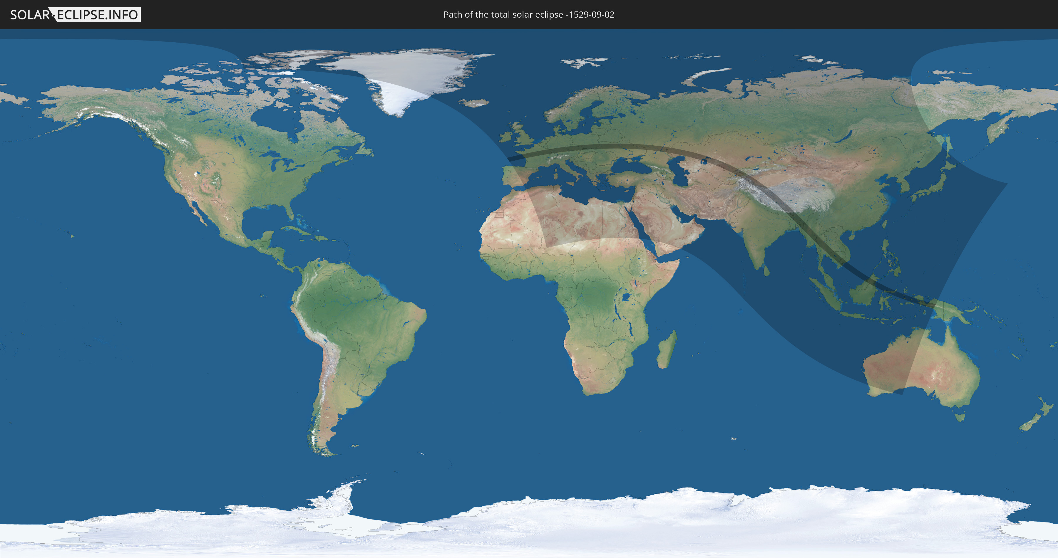
Die Sonnenfinsternis am 09/02/-1529 kann man in 116 Ländern als partielle Sonnenfinsternis beobachten.
Der Finsternispfad verläuft durch 24 Länder. Nur in diesen Ländern ist sie als total Sonnenfinsternis zu sehen.
In den folgenden Ländern ist die Sonnenfinsternis total zu sehen
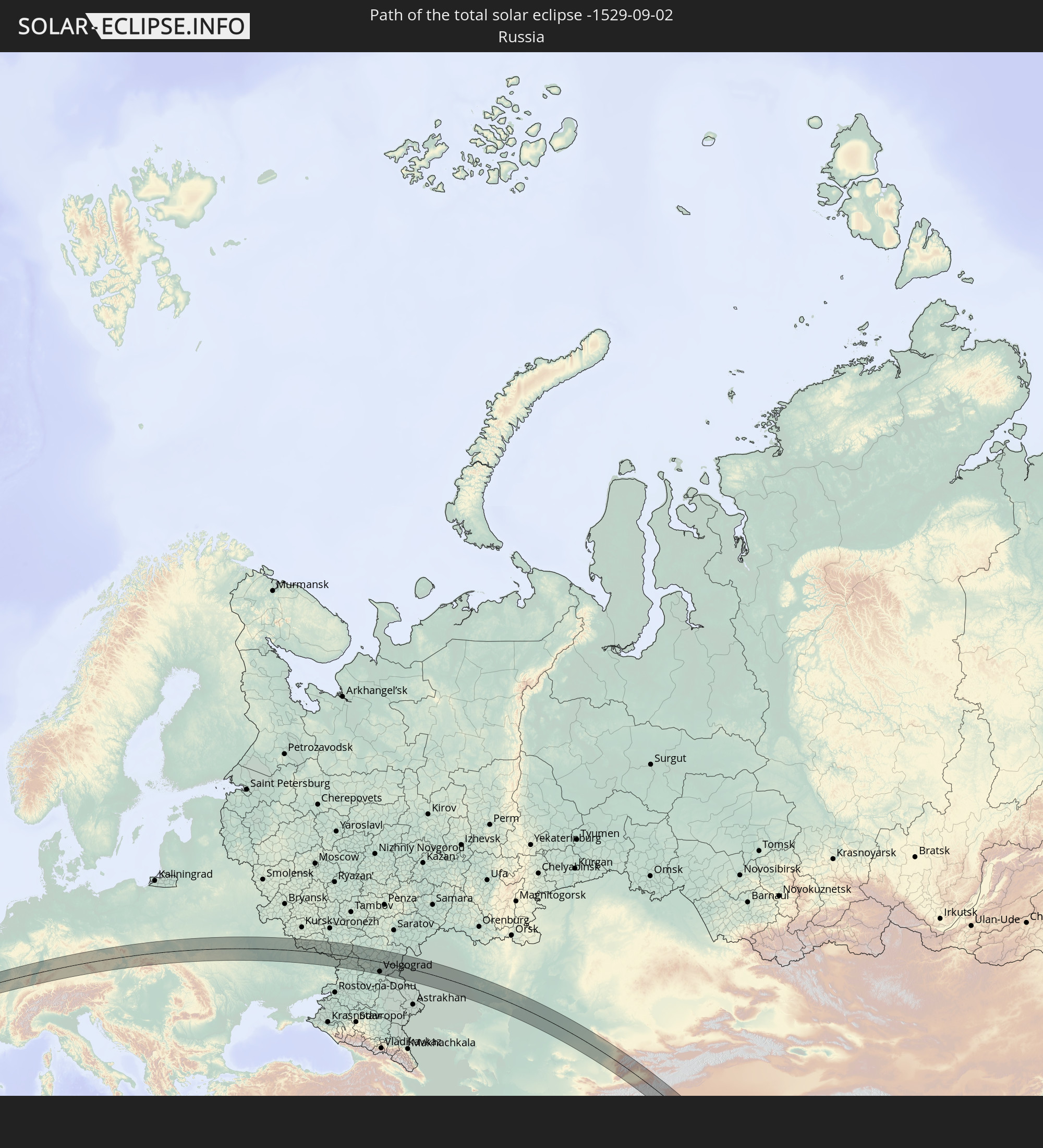 Russia
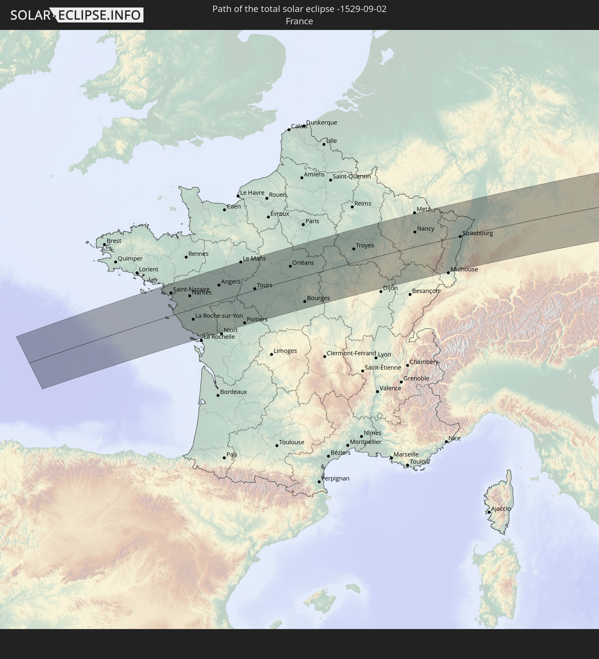 France
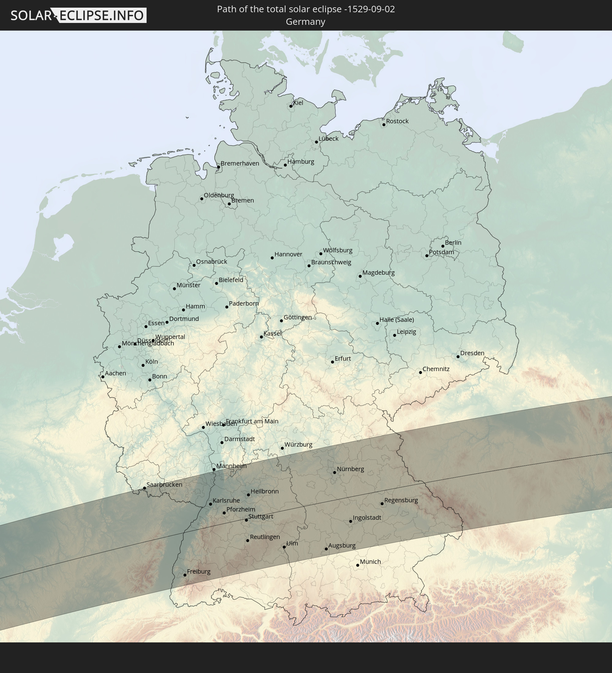 Germany
 Austria
 Czechia
 Poland
 Slovakia
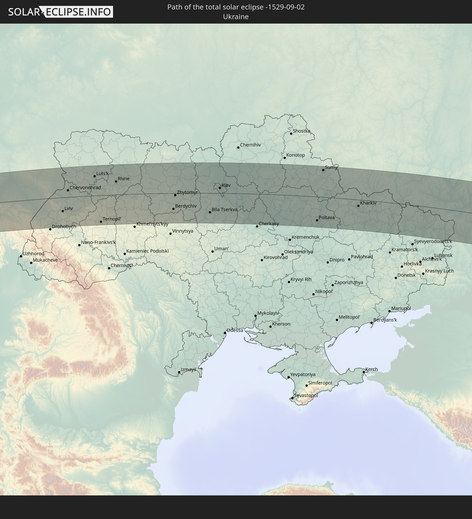 Ukraine
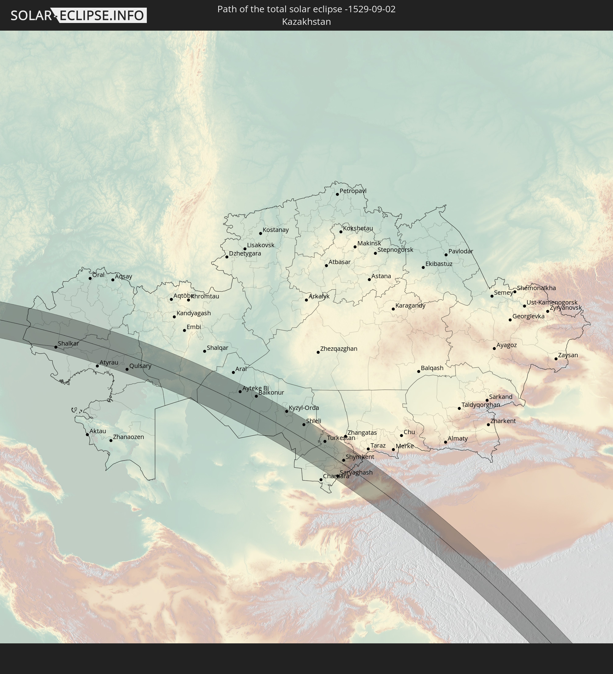 Kazakhstan
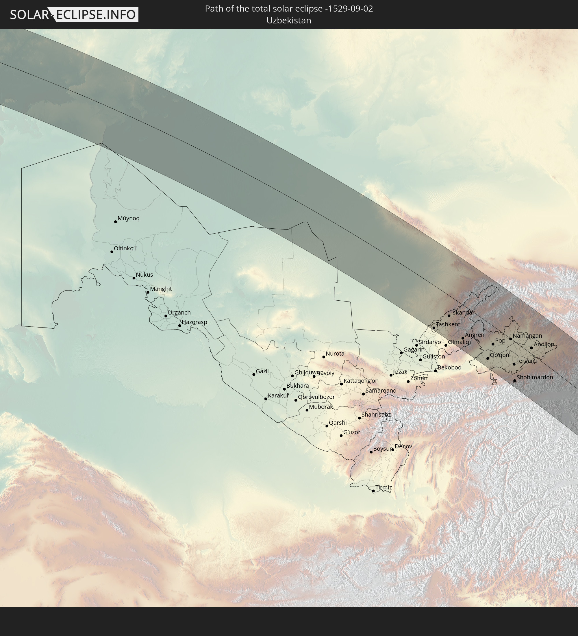 Uzbekistan
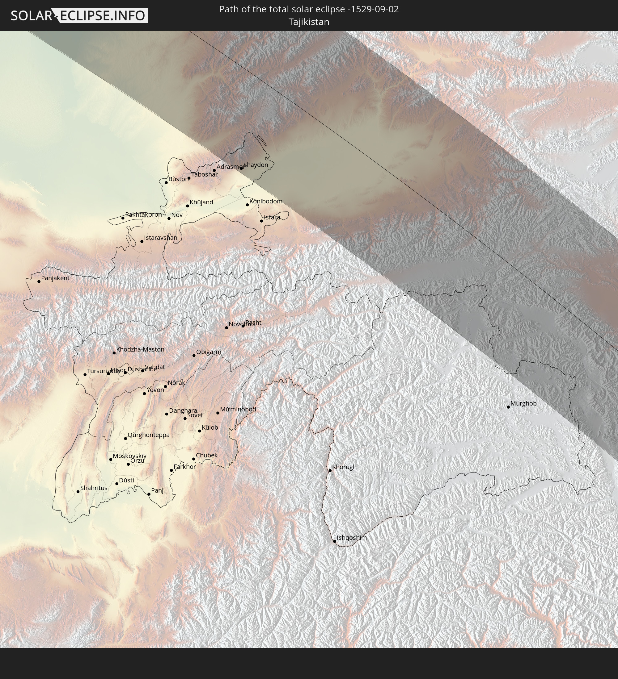 Tajikistan
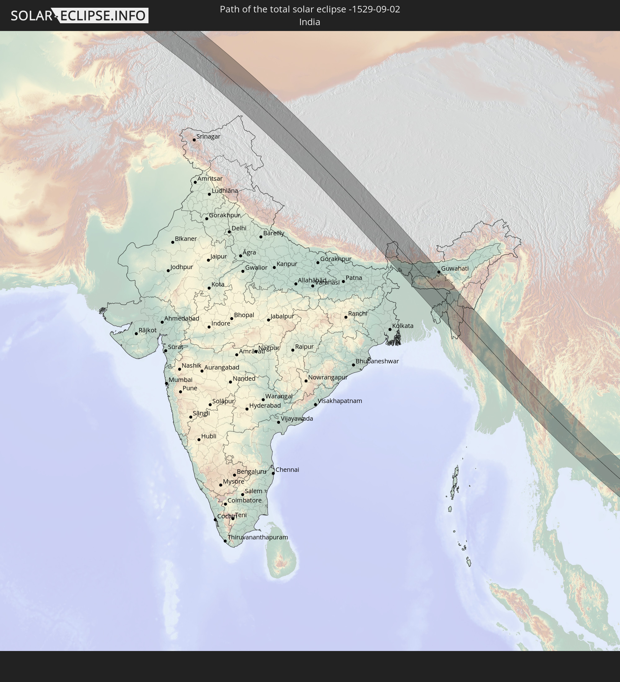 India
India
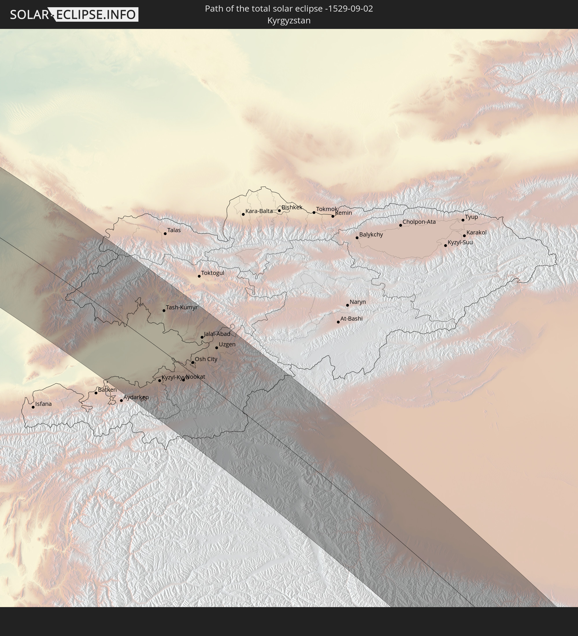 Kyrgyzstan
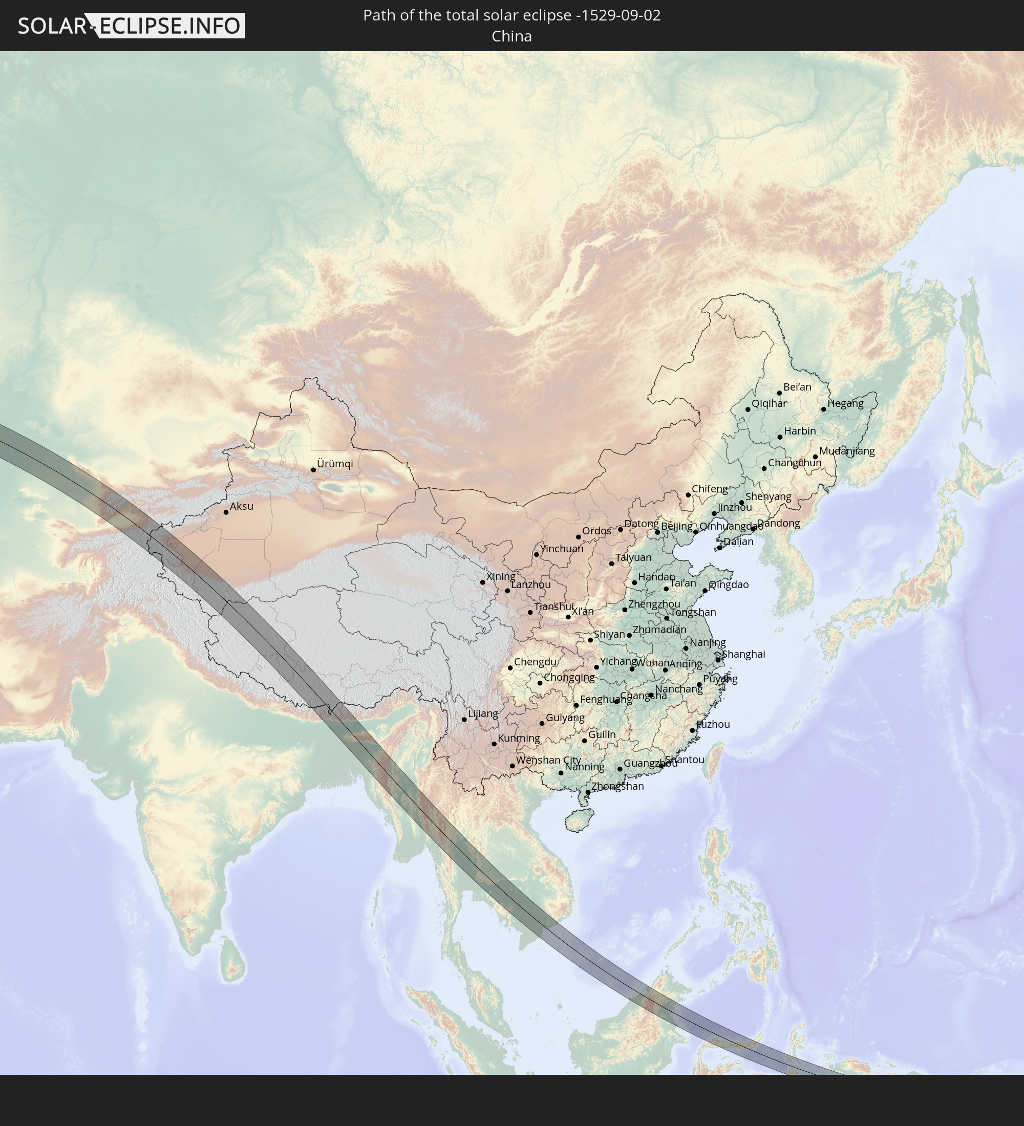 China
China
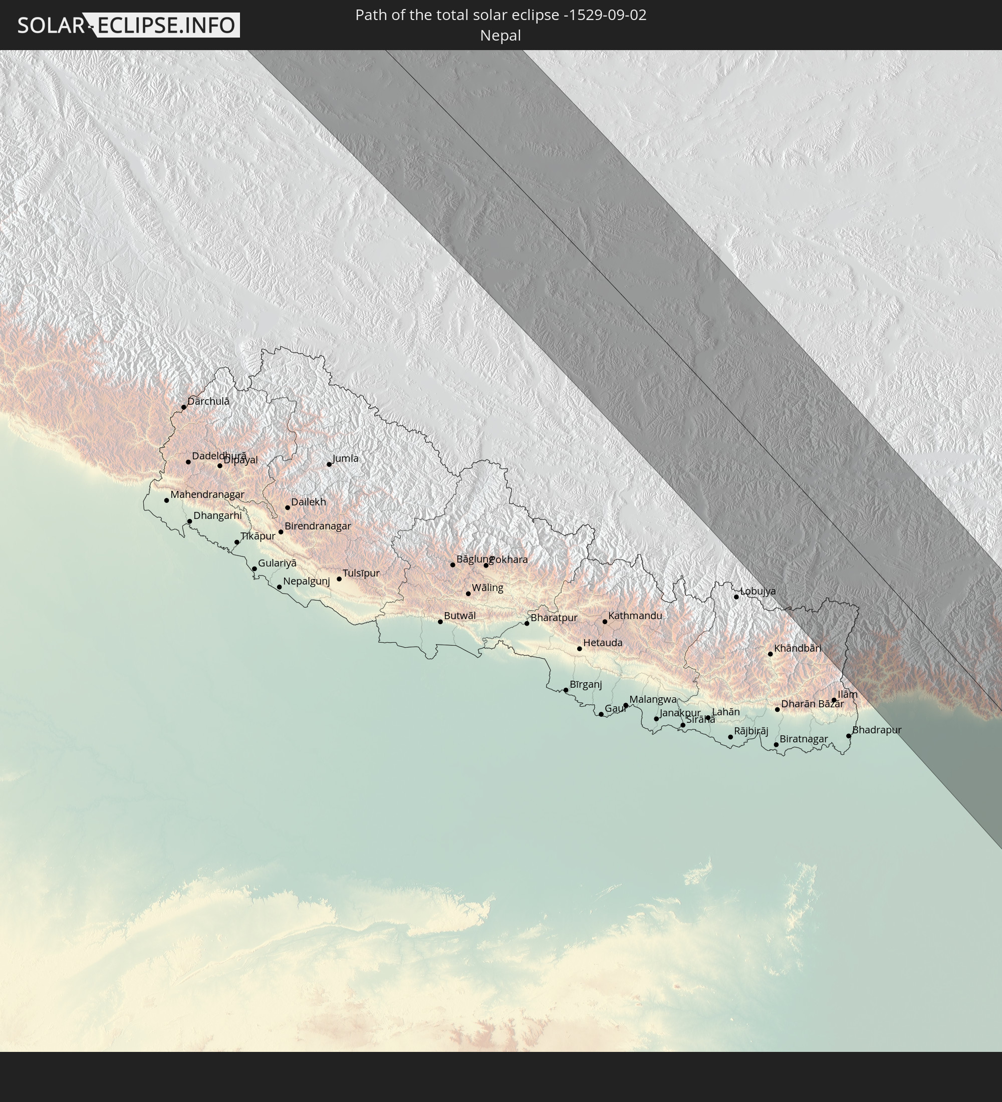 Nepal
Nepal
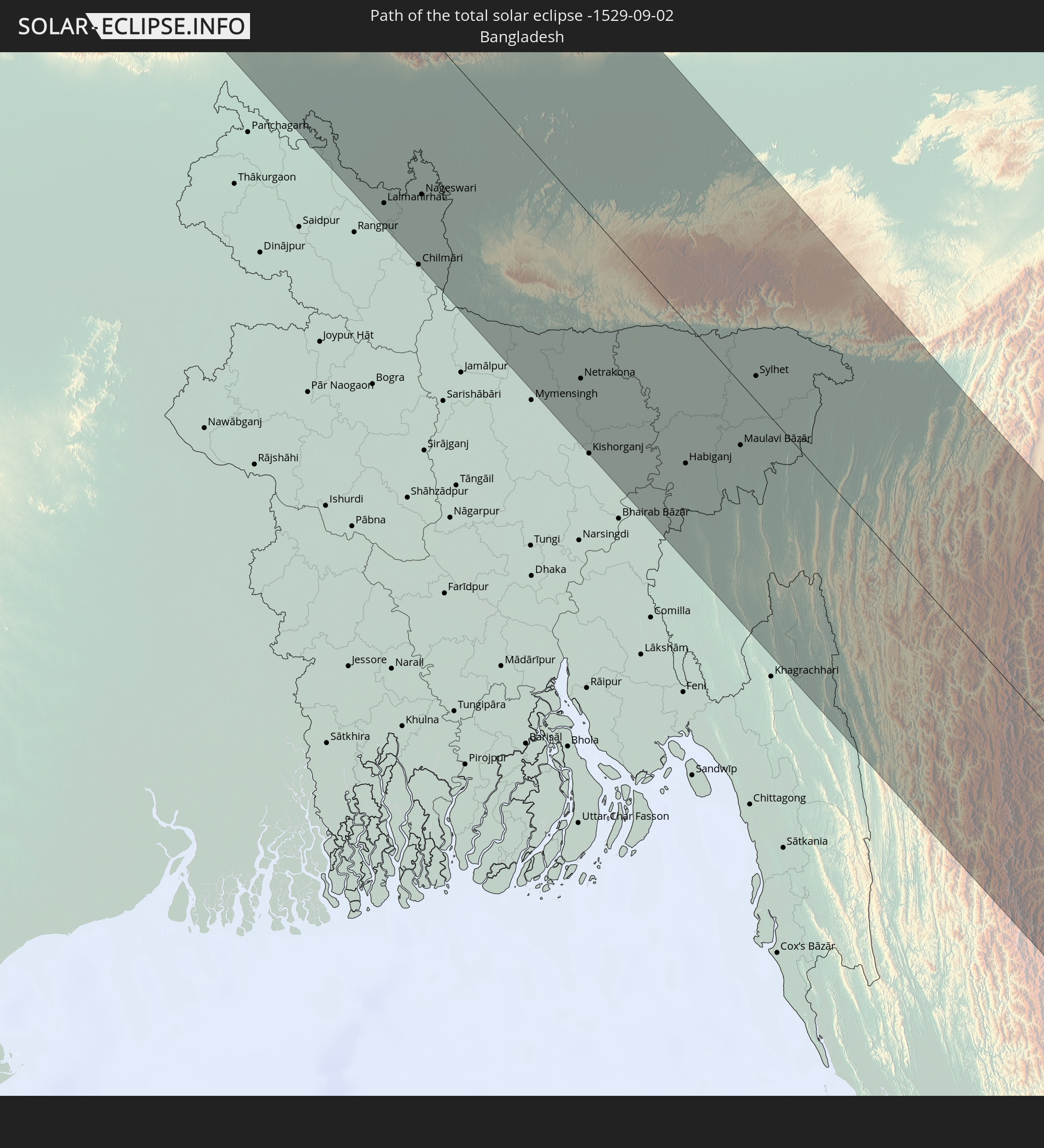 Bangladesh
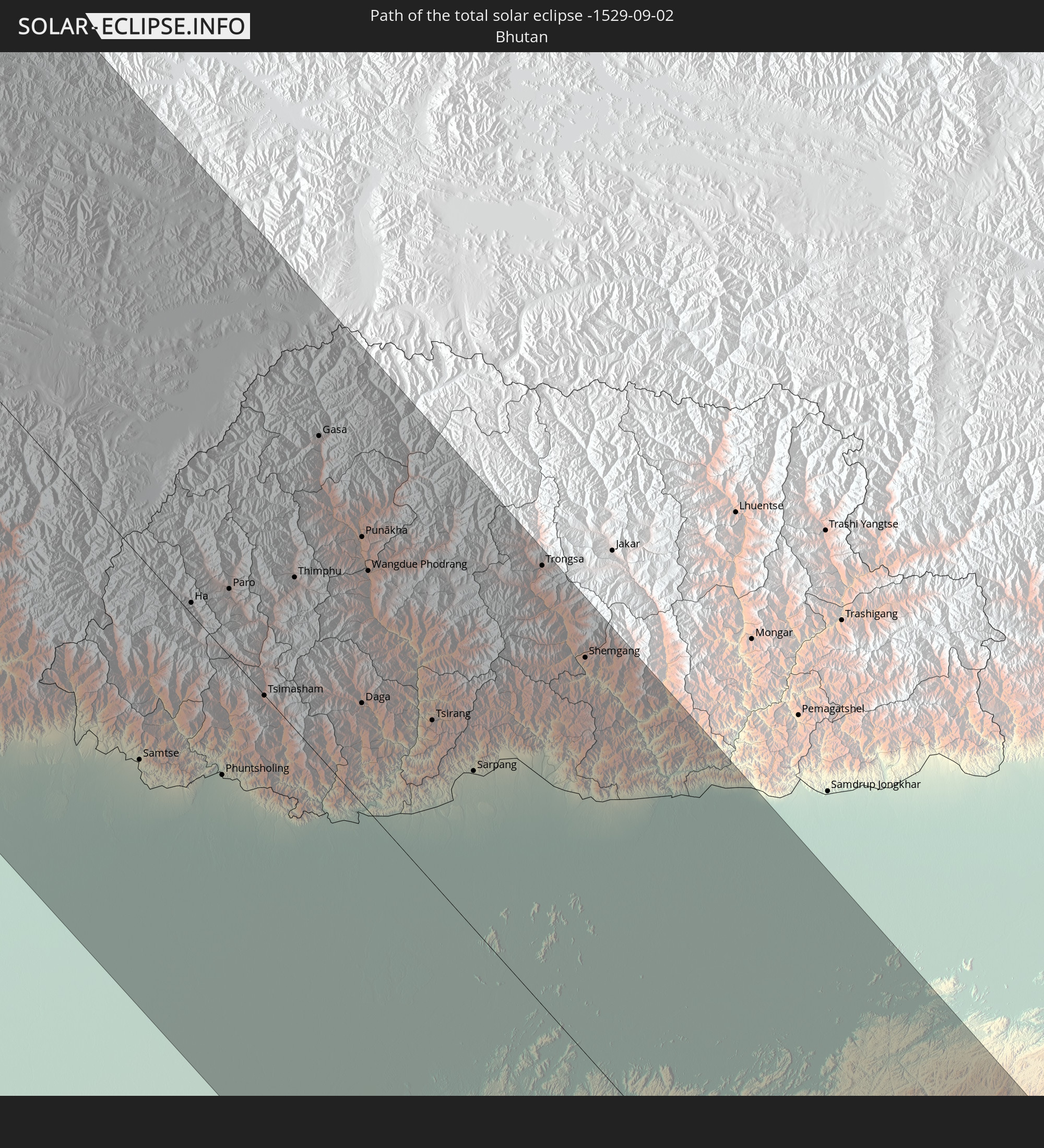 Bhutan
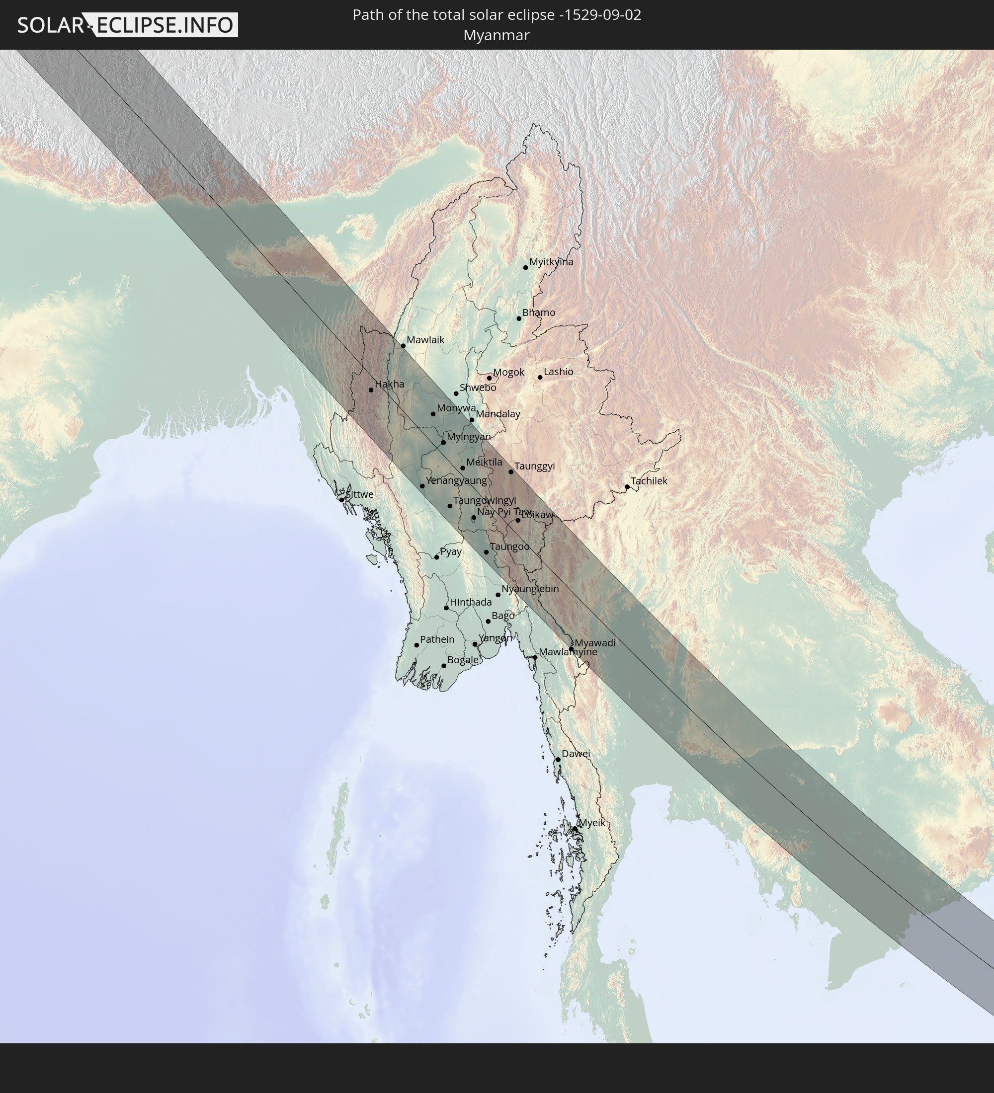 Myanmar
 Indonesia
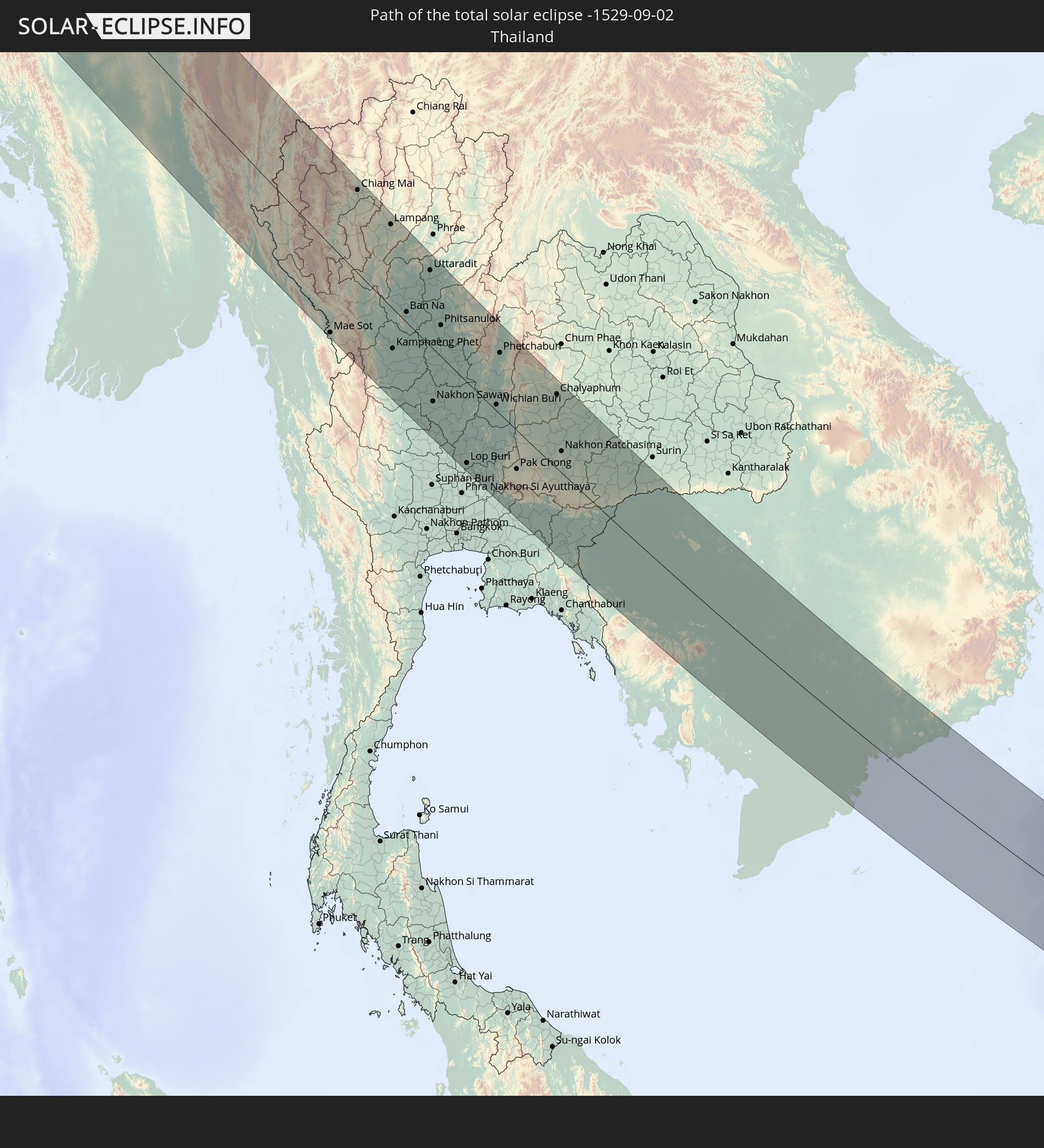 Thailand
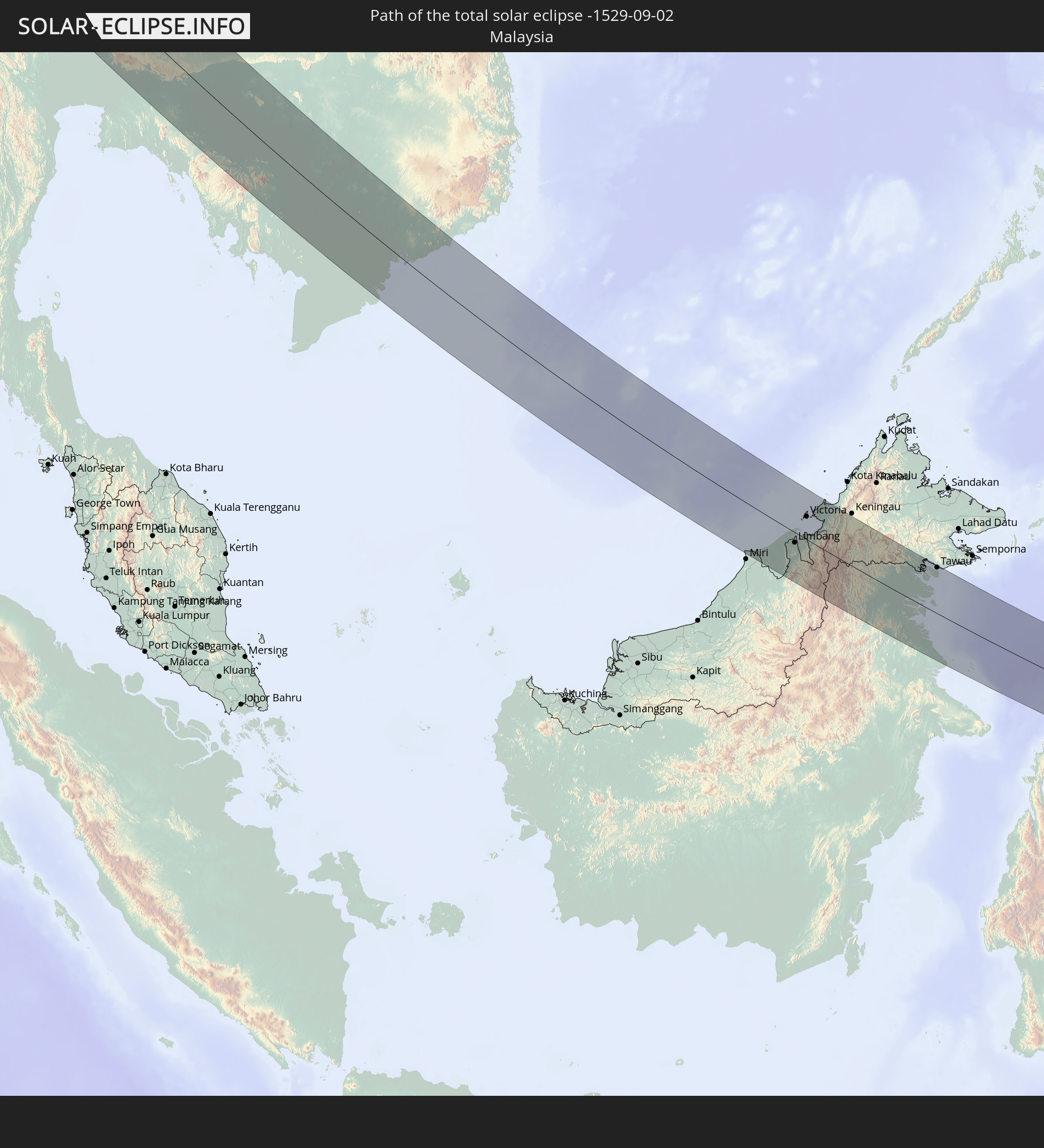 Malaysia
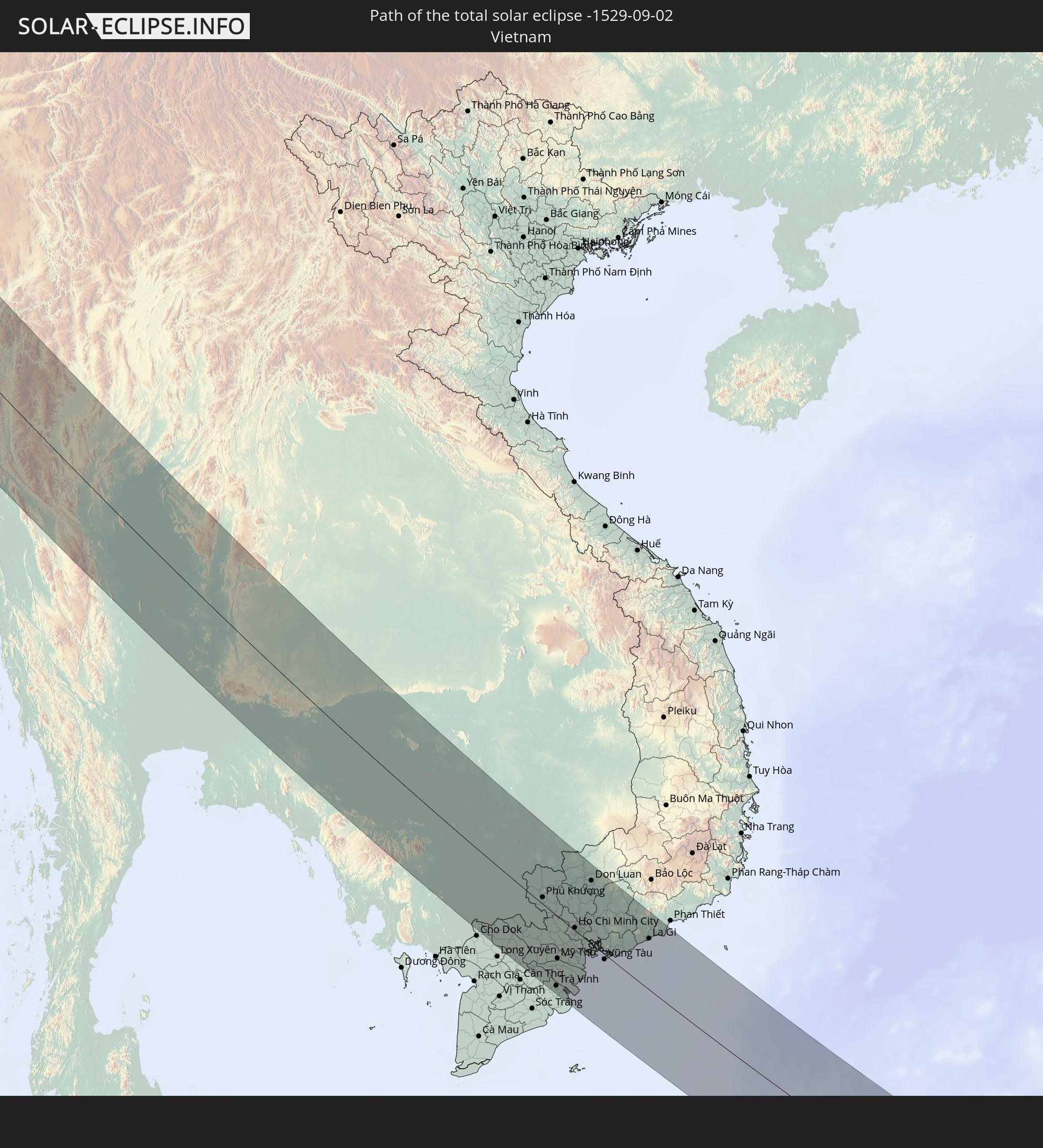 Vietnam
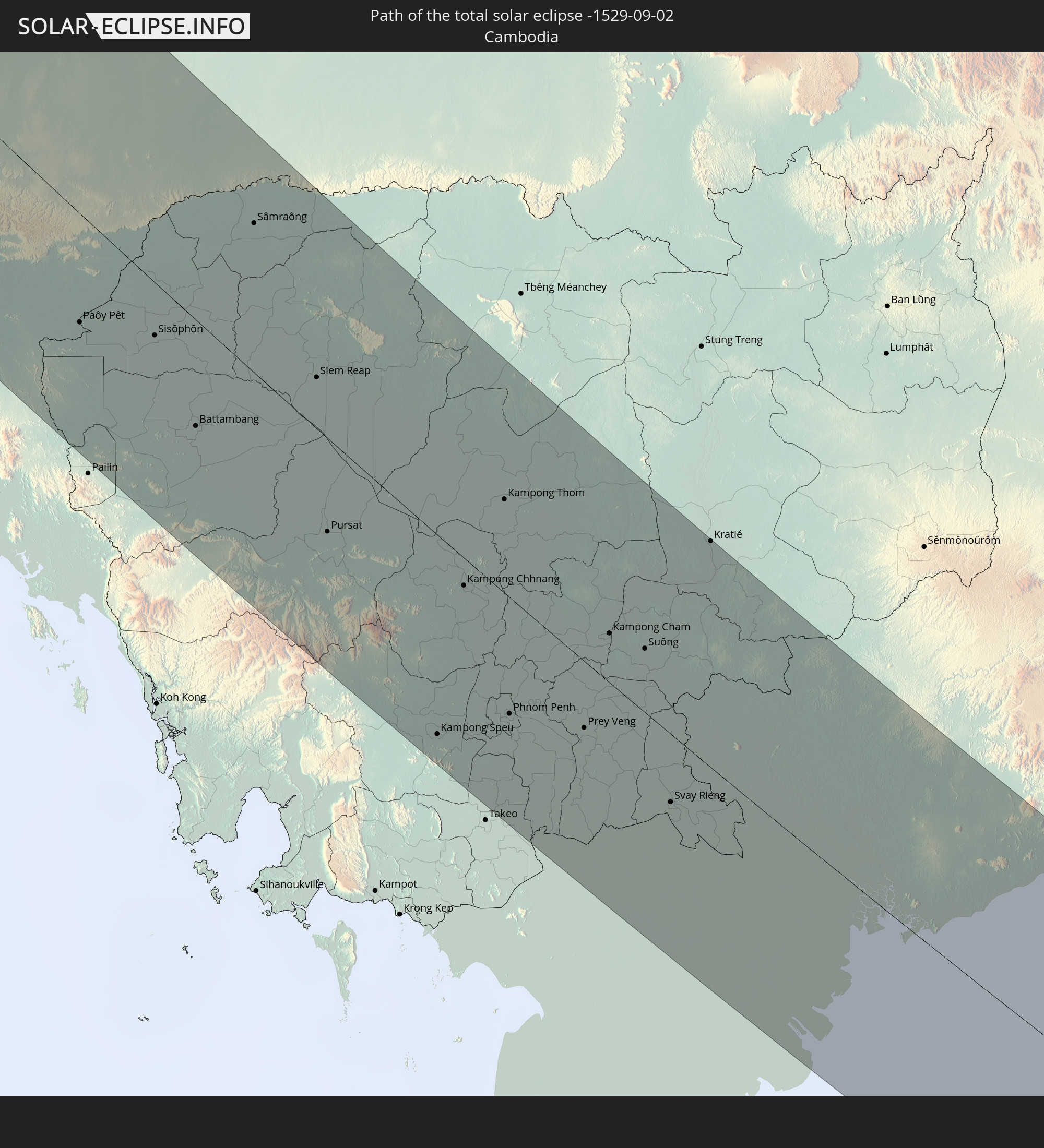 Cambodia
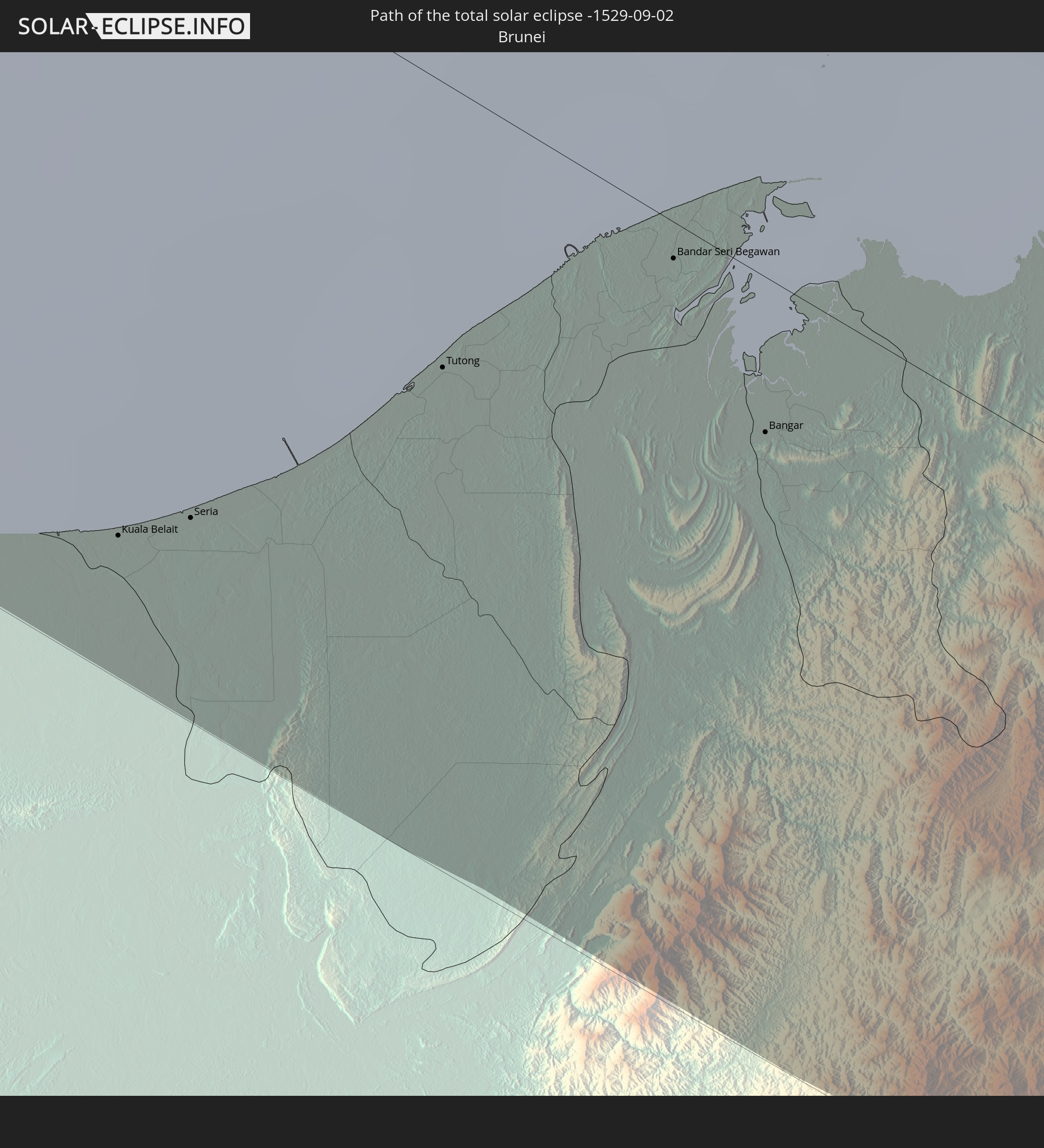 Brunei
In den folgenden Ländern ist die Sonnenfinsternis partiell zu sehen
 Russia
 Canada
 Greenland
 Iceland
 Spain
Spain
 Republic of Ireland
 Svalbard and Jan Mayen
 Algeria
 United Kingdom
 Faroe Islands
 France
 Isle of Man
 Guernsey
 Jersey
 Niger
Niger
 Andorra
 Belgium
 Netherlands
 Norway
 Luxembourg
 Germany
 Switzerland
 Italy
Italy
 Monaco
 Tunisia
 Denmark
 Libya
Libya
 Liechtenstein
 Austria
 Sweden
 Czechia
 San Marino
 Vatican City
 Slovenia
 Chad
Chad
 Croatia
 Poland
 Malta
Malta
 Bosnia and Herzegovina
 Hungary
 Slovakia
 Montenegro
 Serbia
 Albania
 Åland Islands
 Greece
 Romania
 Republic of Macedonia
 Finland
 Lithuania
 Latvia
 Estonia
 Sudan
Sudan
 Ukraine
 Bulgaria
 Belarus
 Egypt
Egypt
 Turkey
 Moldova
 Cyprus
 State of Palestine
 Israel
 Saudi Arabia
 Jordan
 Lebanon
 Syria
Syria
 Iraq
Iraq
 Georgia
 Yemen
Yemen
 Armenia
 Iran
Iran
 Azerbaijan
 Kazakhstan
 Kuwait
 Bahrain
 Qatar
Qatar
 United Arab Emirates
 Oman
Oman
 Turkmenistan
 Uzbekistan
 Afghanistan
 Pakistan
 Tajikistan
 India
India
 Kyrgyzstan
 Maldives
 China
China
 Sri Lanka
 Nepal
Nepal
 Mongolia
 Bangladesh
 Bhutan
 Myanmar
 Indonesia
 Cocos Islands
 Thailand
 Malaysia
 Laos
Laos
 Vietnam
 Cambodia
 Singapore
 Christmas Island
 Australia
 Macau
Macau
 Hong Kong
 Brunei
 Taiwan
 Philippines
 Japan
Japan
 East Timor
 North Korea
 South Korea
 Palau
Palau
 Federated States of Micronesia
 Guam
Guam
 Northern Mariana Islands
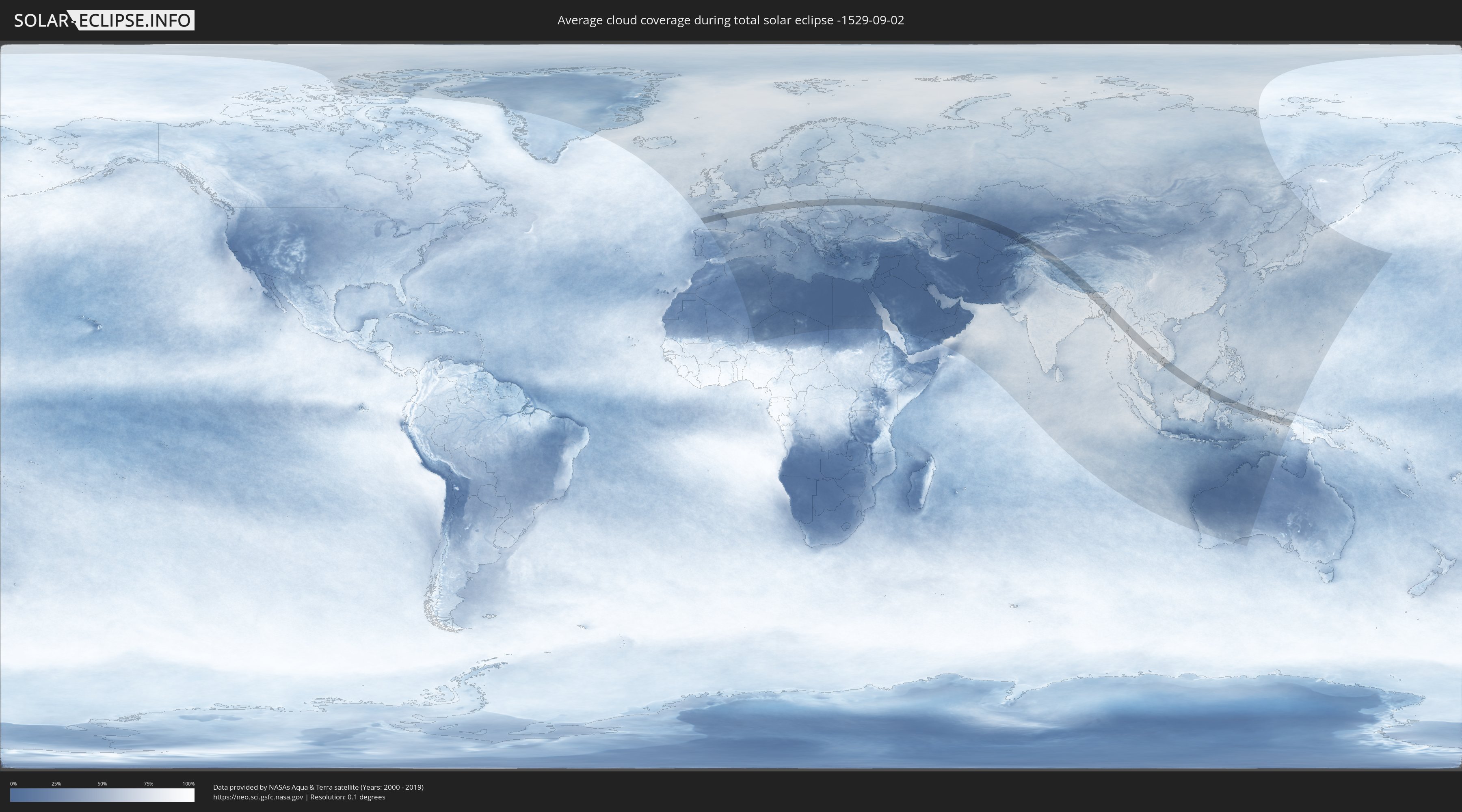
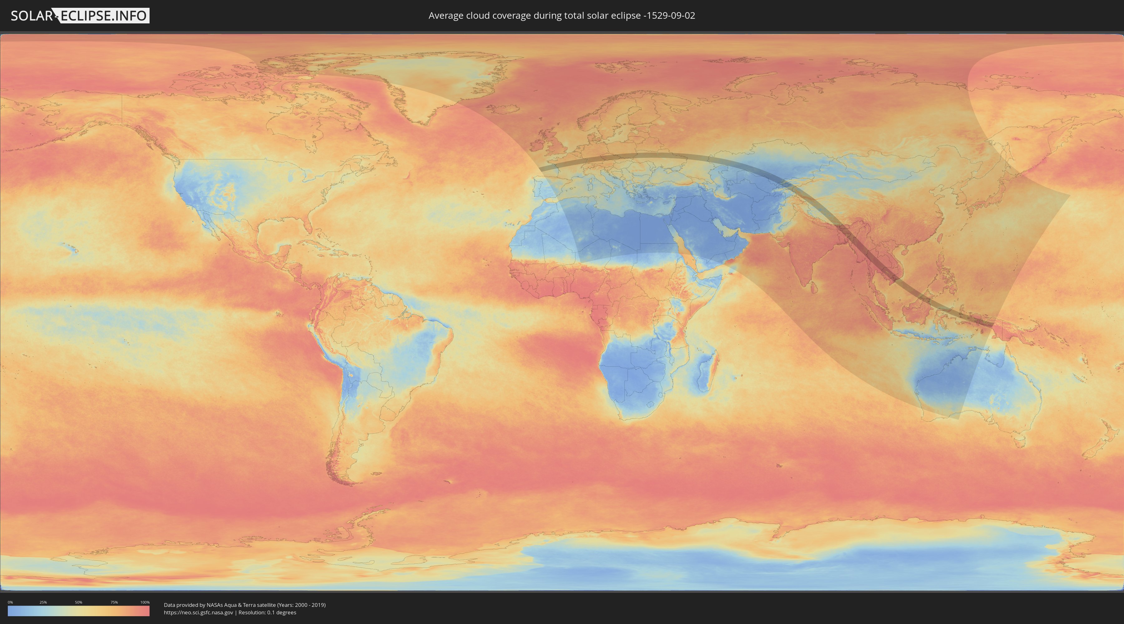
How will be the weather during the total solar eclipse on 09/02/-1529?
Where is the best place to see the total solar eclipse of 09/02/-1529?
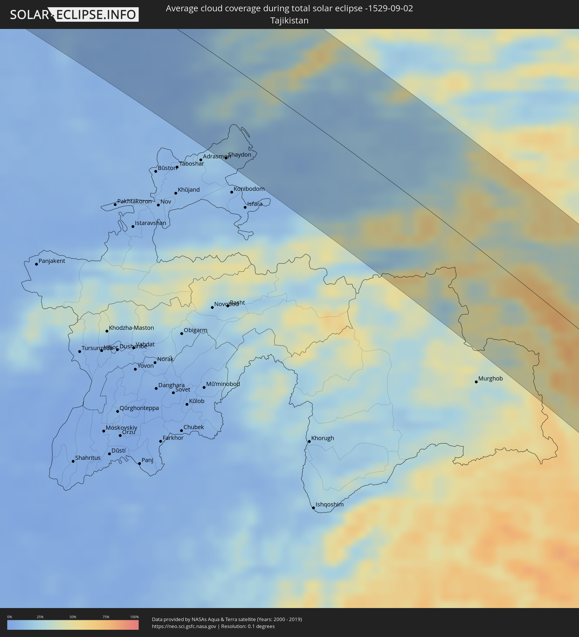
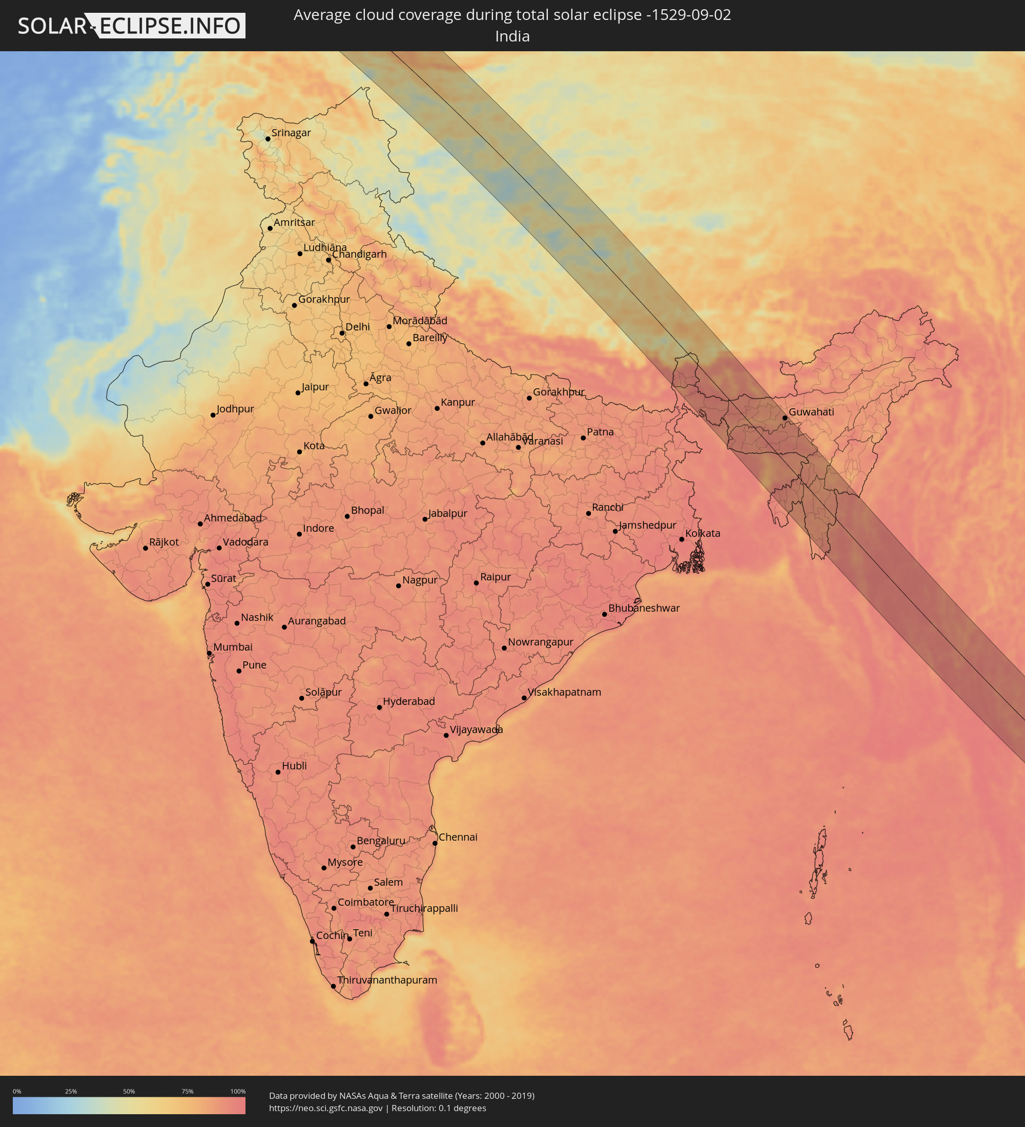
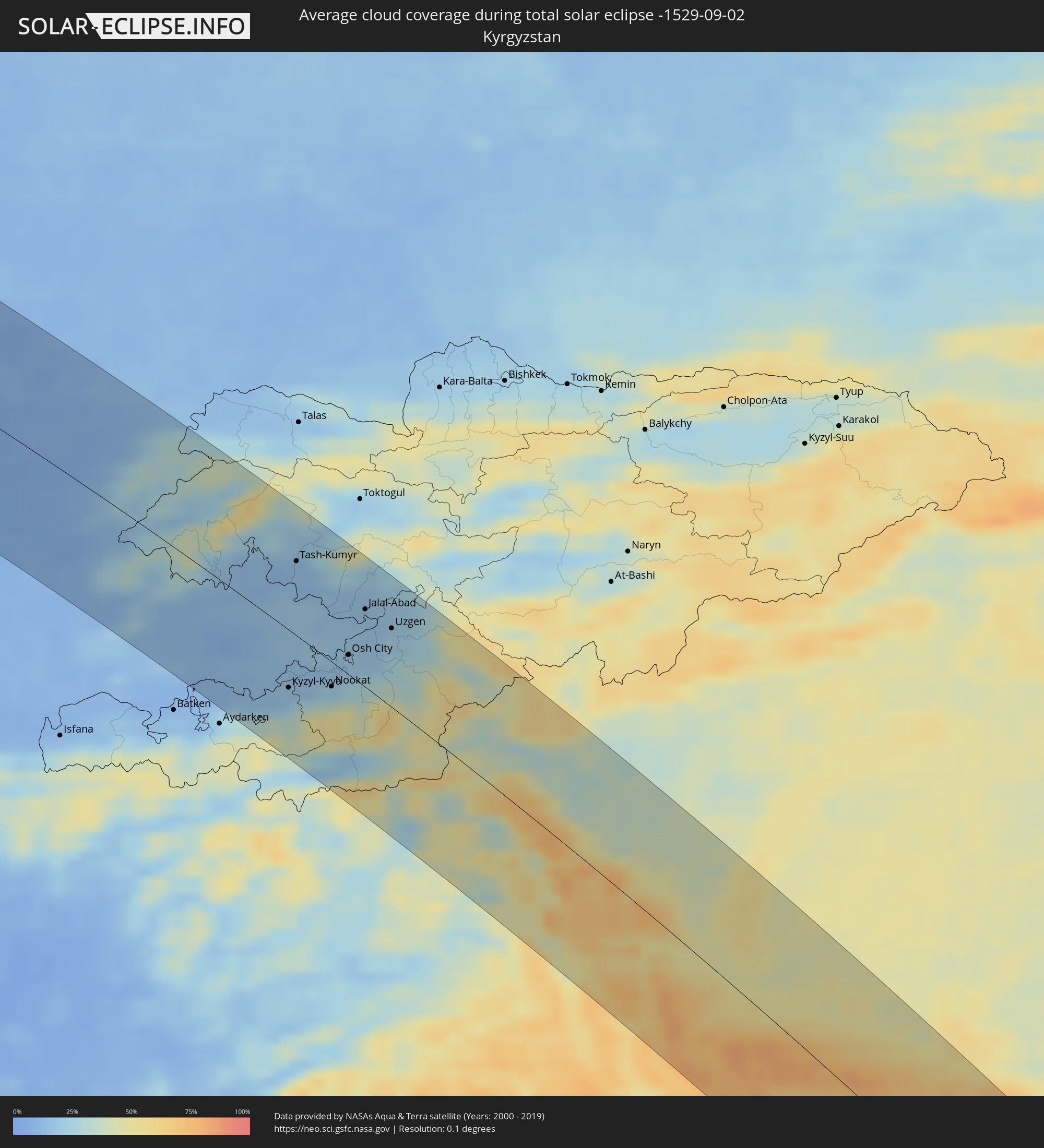
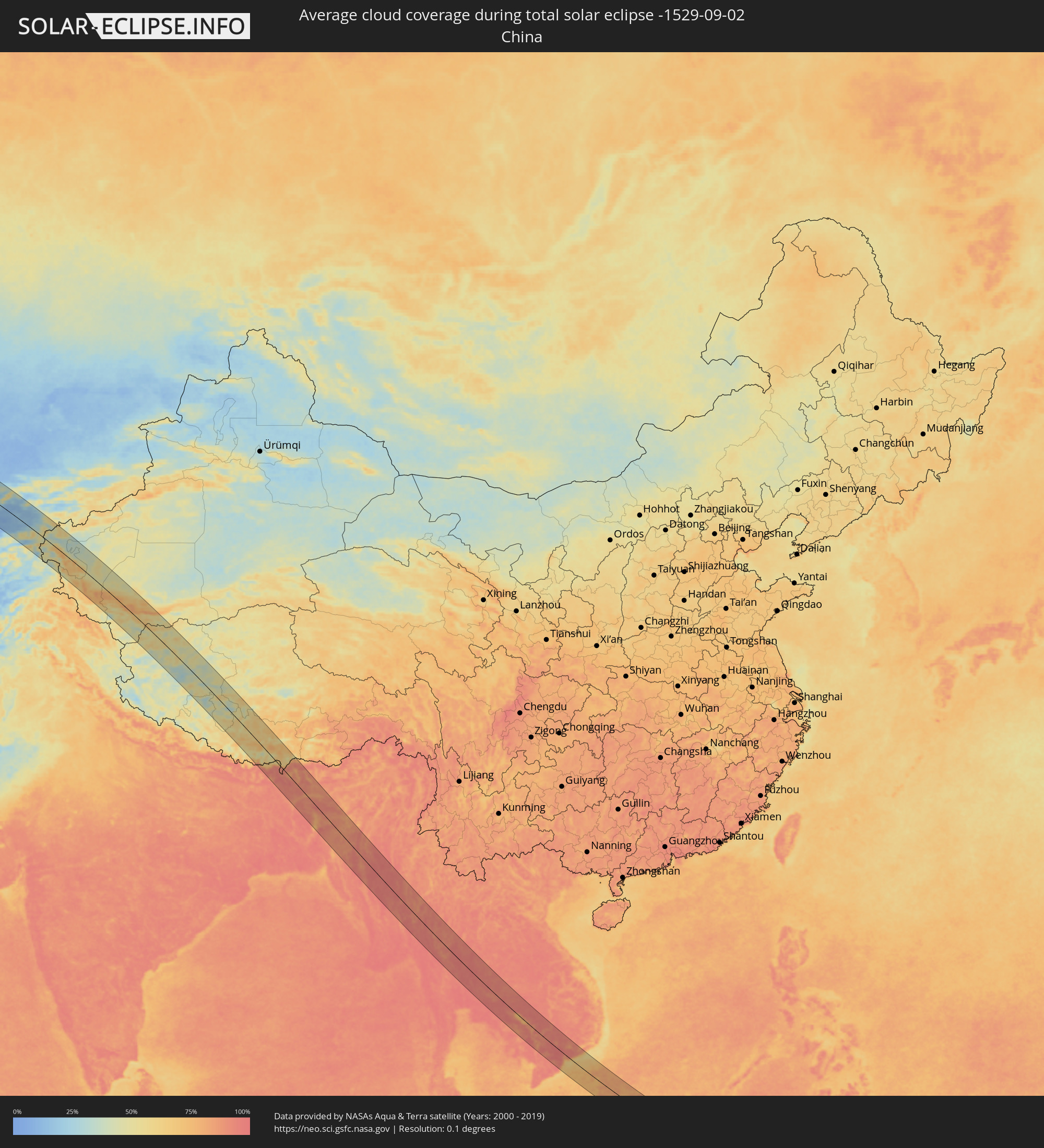
The following maps show the average cloud coverage for the day of the total solar eclipse.
With the help of these maps, it is possible to find the place along the eclipse path, which has the best
chance of a cloudless sky.
Nevertheless, you should consider local circumstances and inform about the weather of your chosen
observation site.
The data is provided by NASAs satellites
AQUA and TERRA.
The cloud maps are averaged over a period of 19 years (2000 - 2019).
Detailed country maps
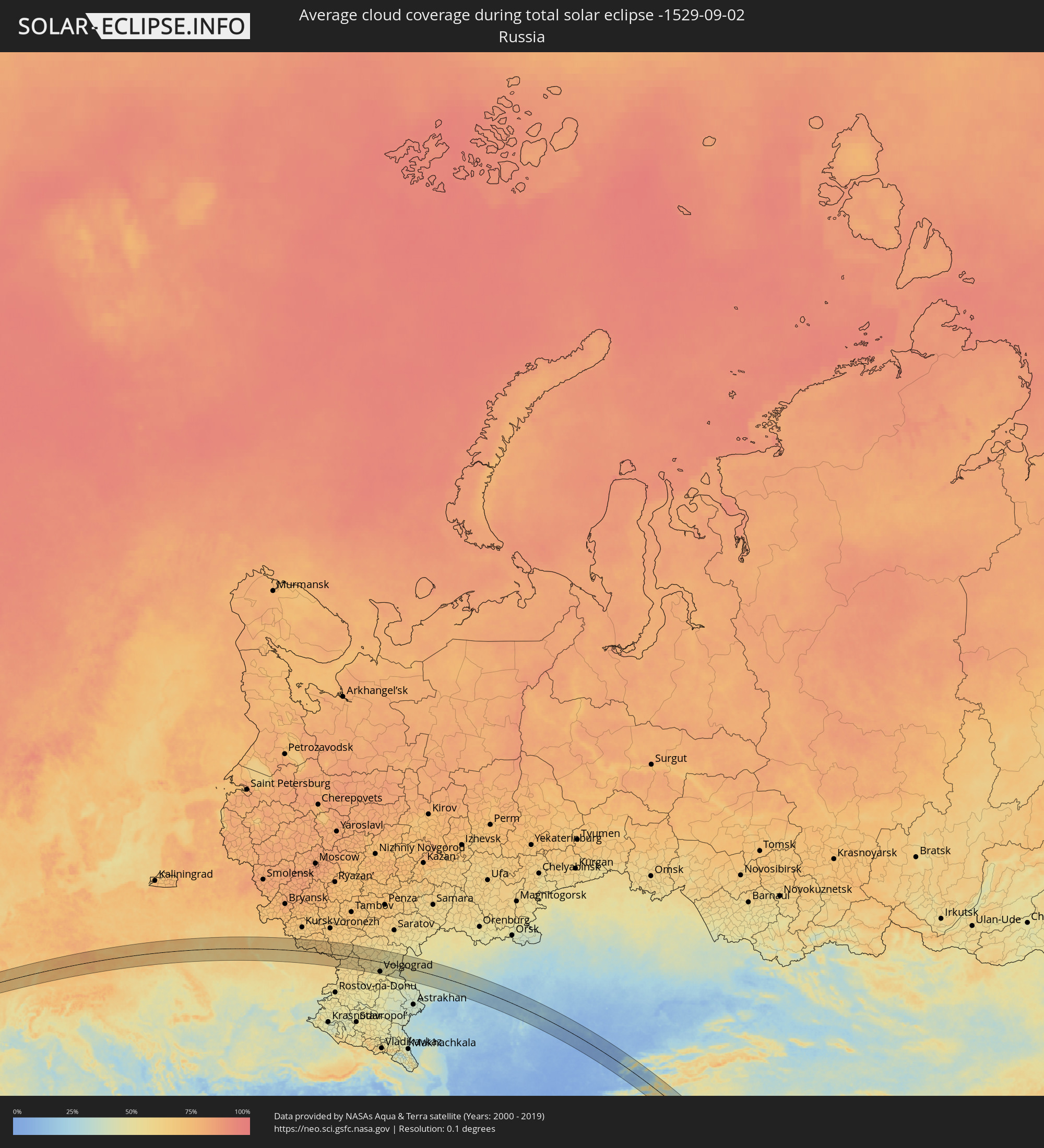 Russia
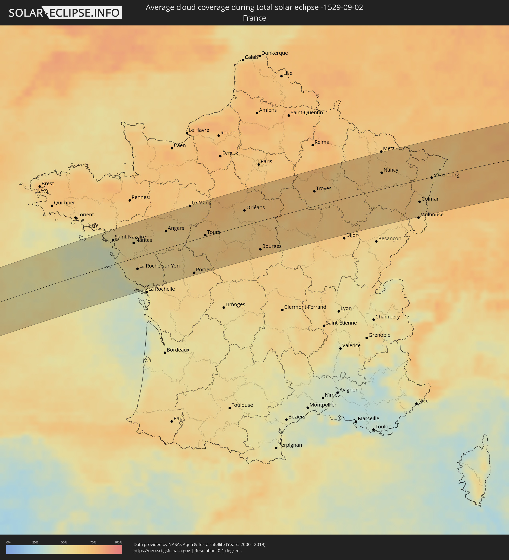 France
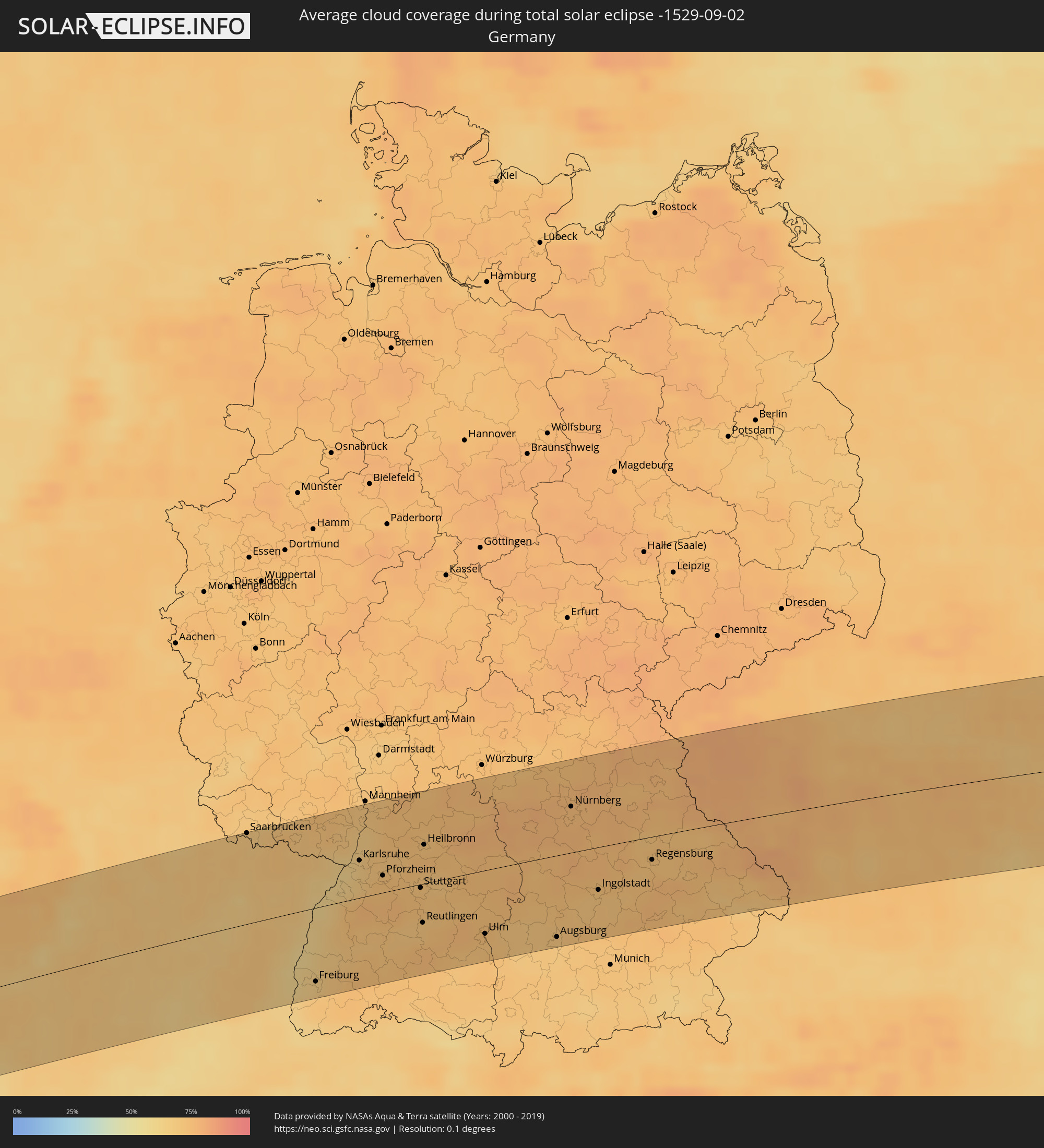 Germany
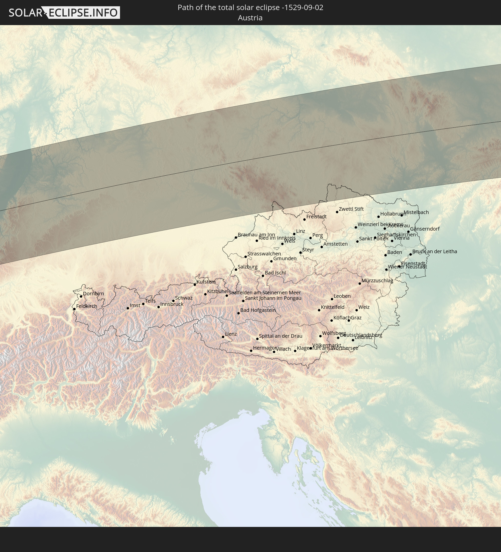
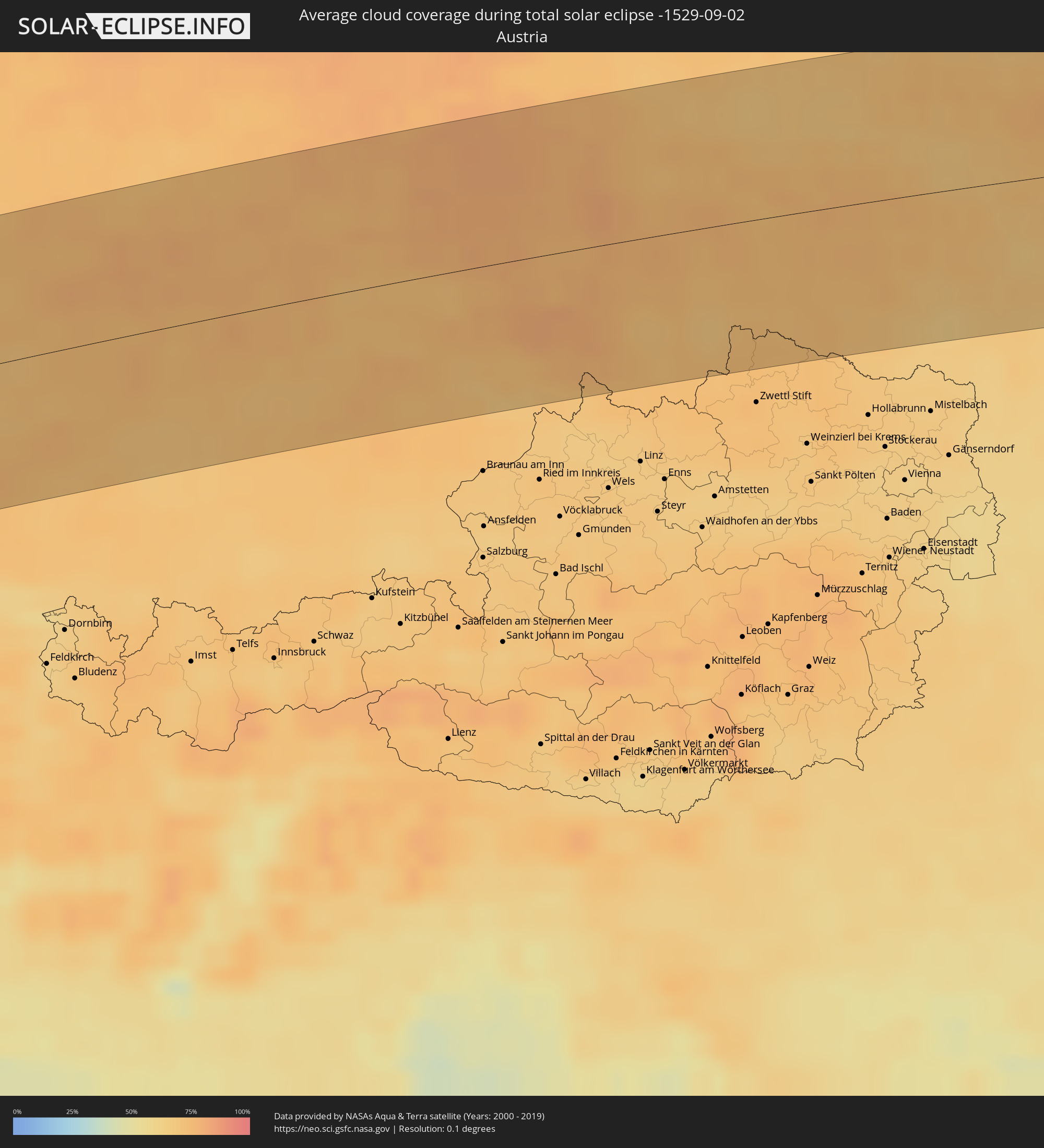 Austria
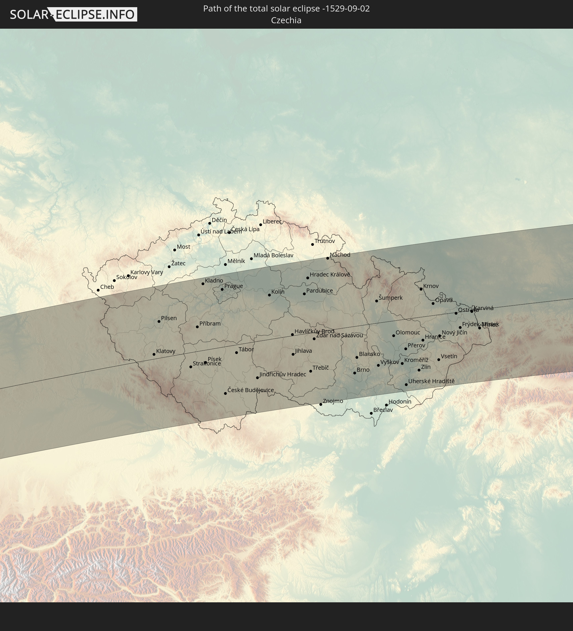
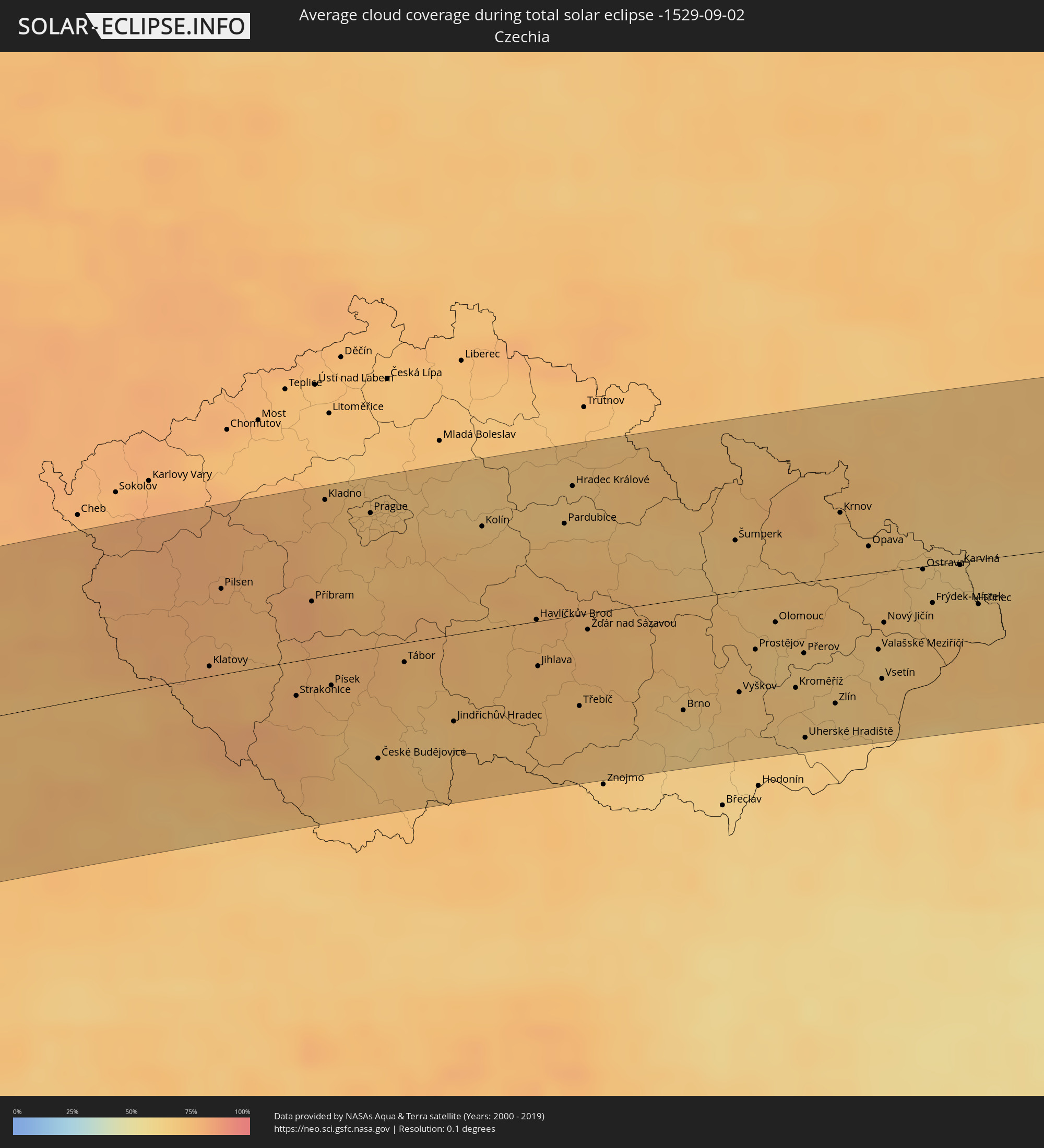 Czechia
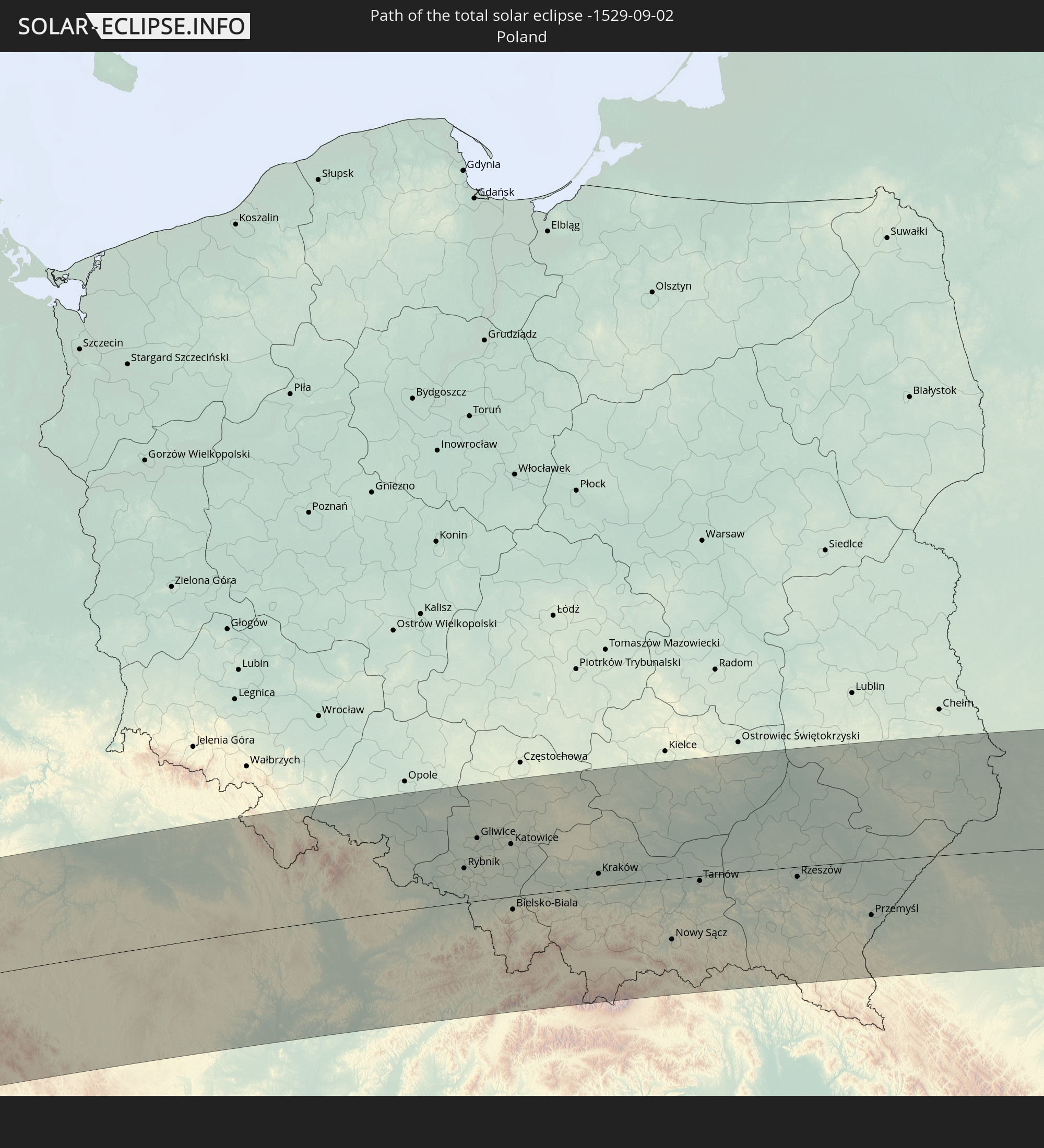
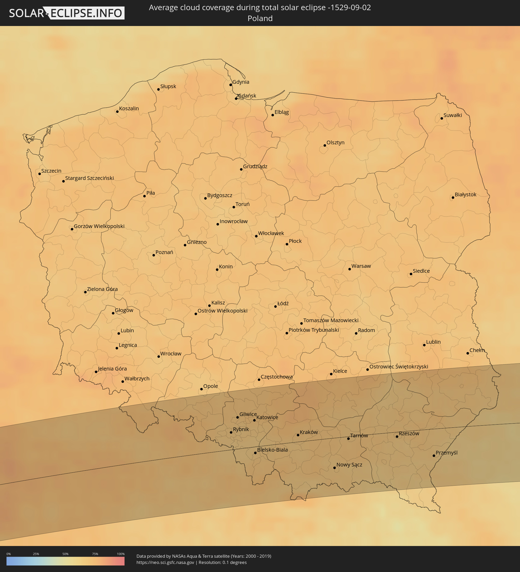 Poland
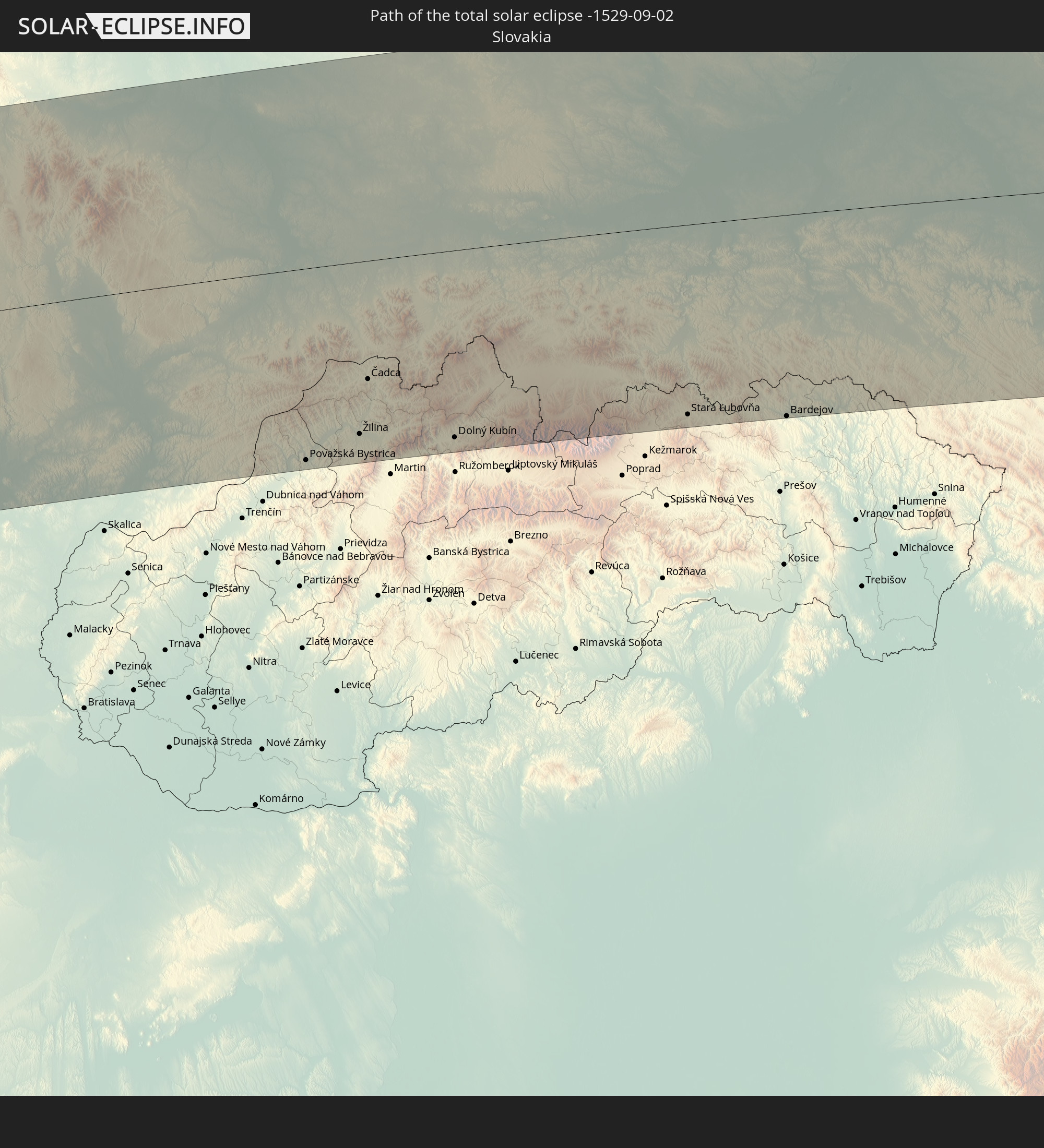
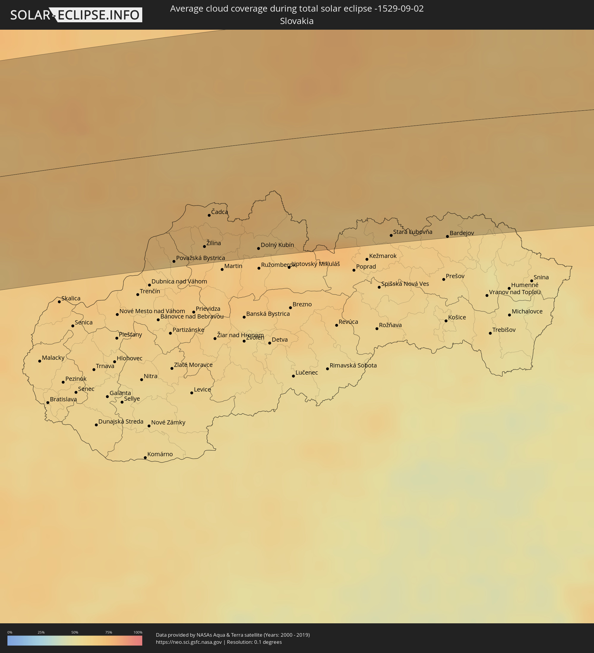 Slovakia
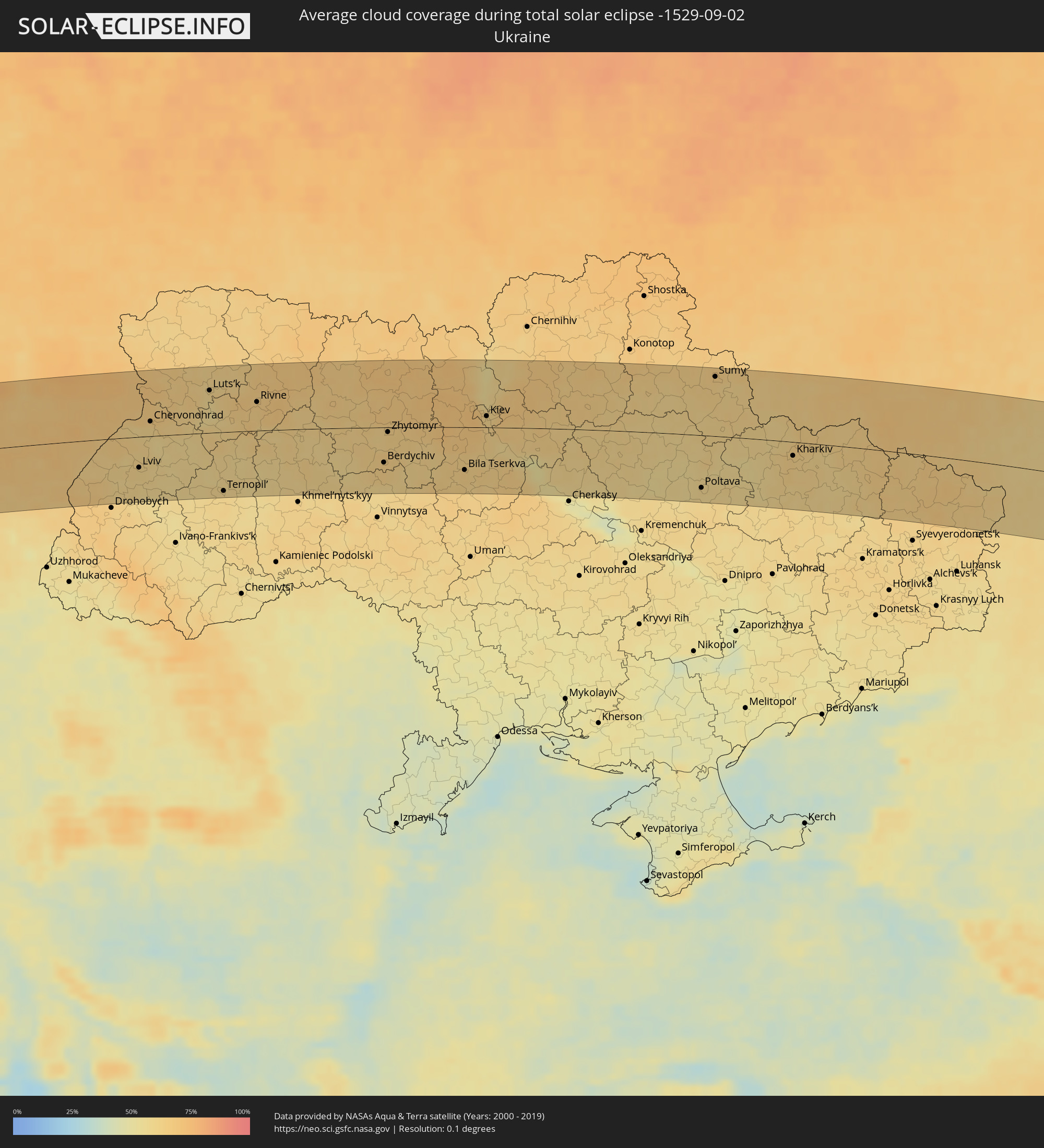 Ukraine
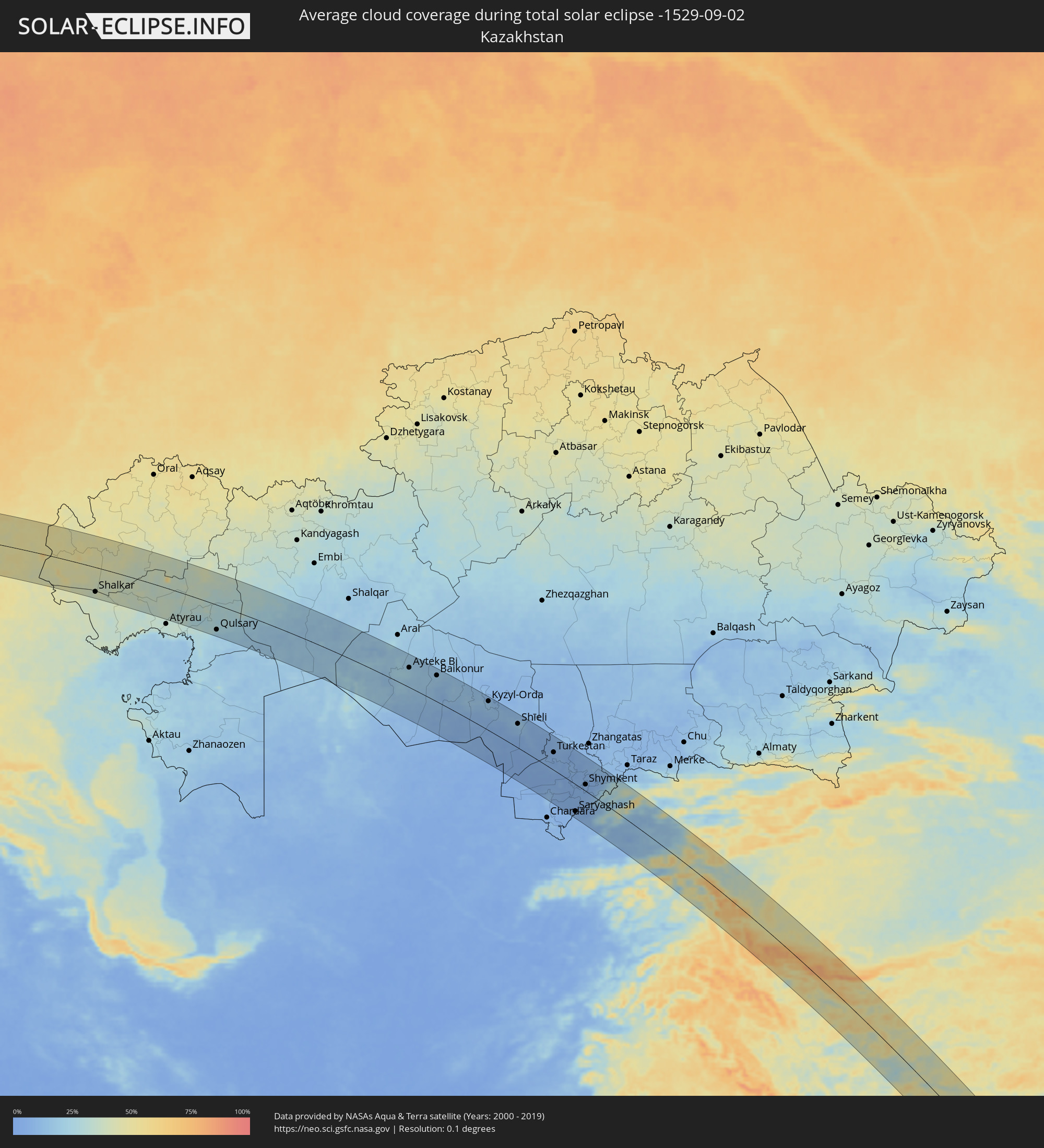 Kazakhstan
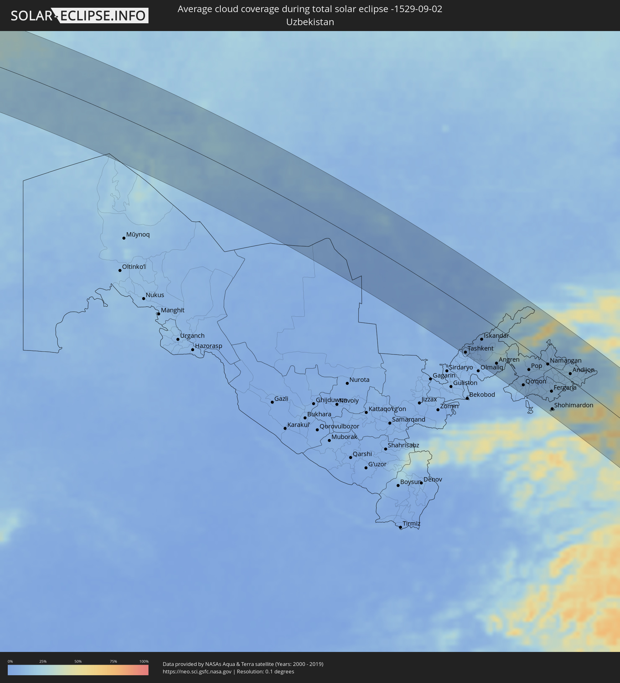 Uzbekistan
 Tajikistan
 India
India
 Kyrgyzstan
 China
China
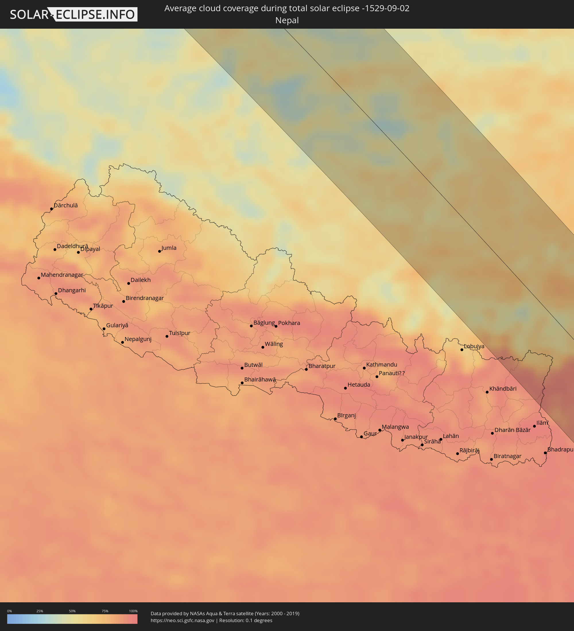 Nepal
Nepal
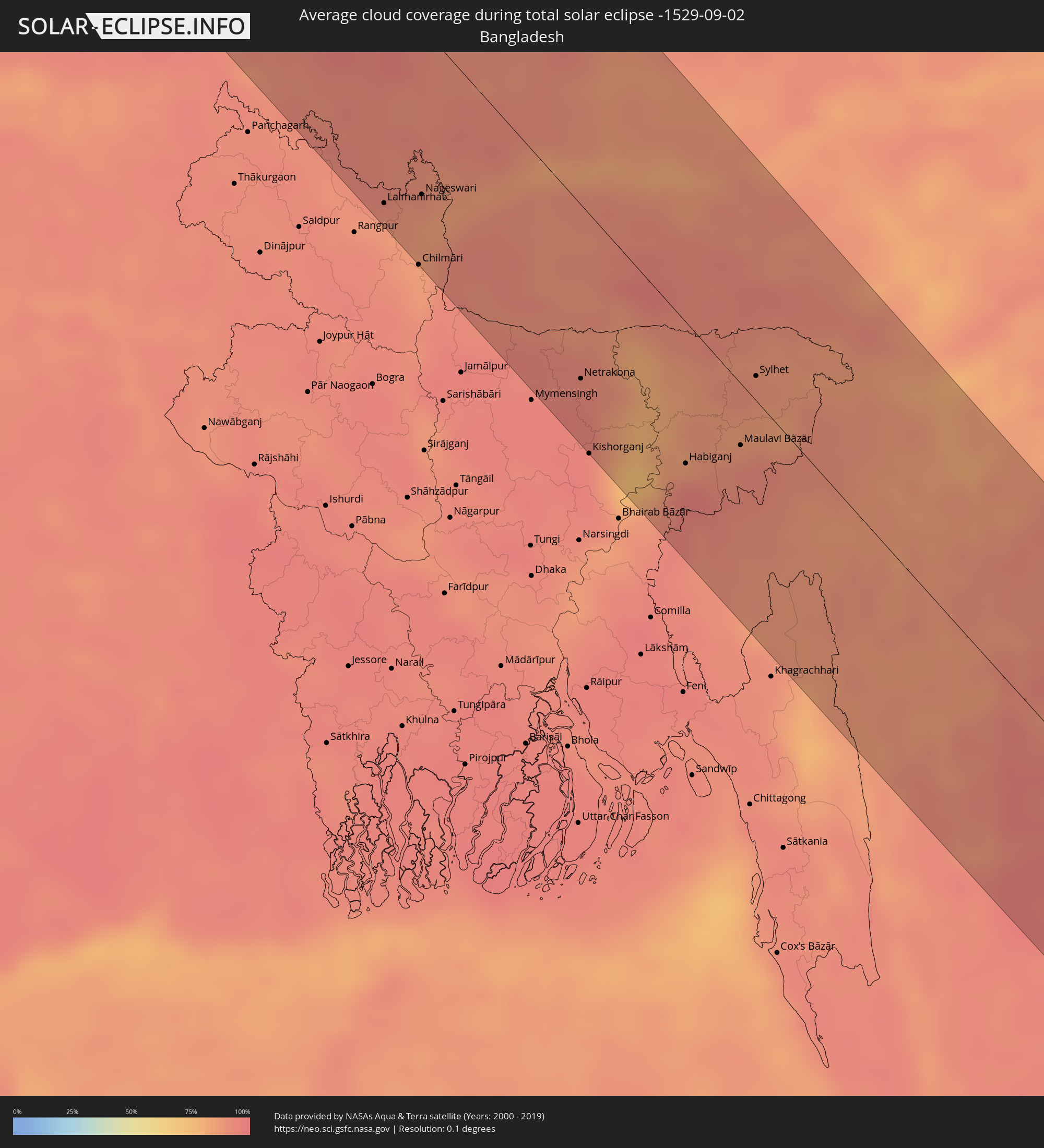 Bangladesh
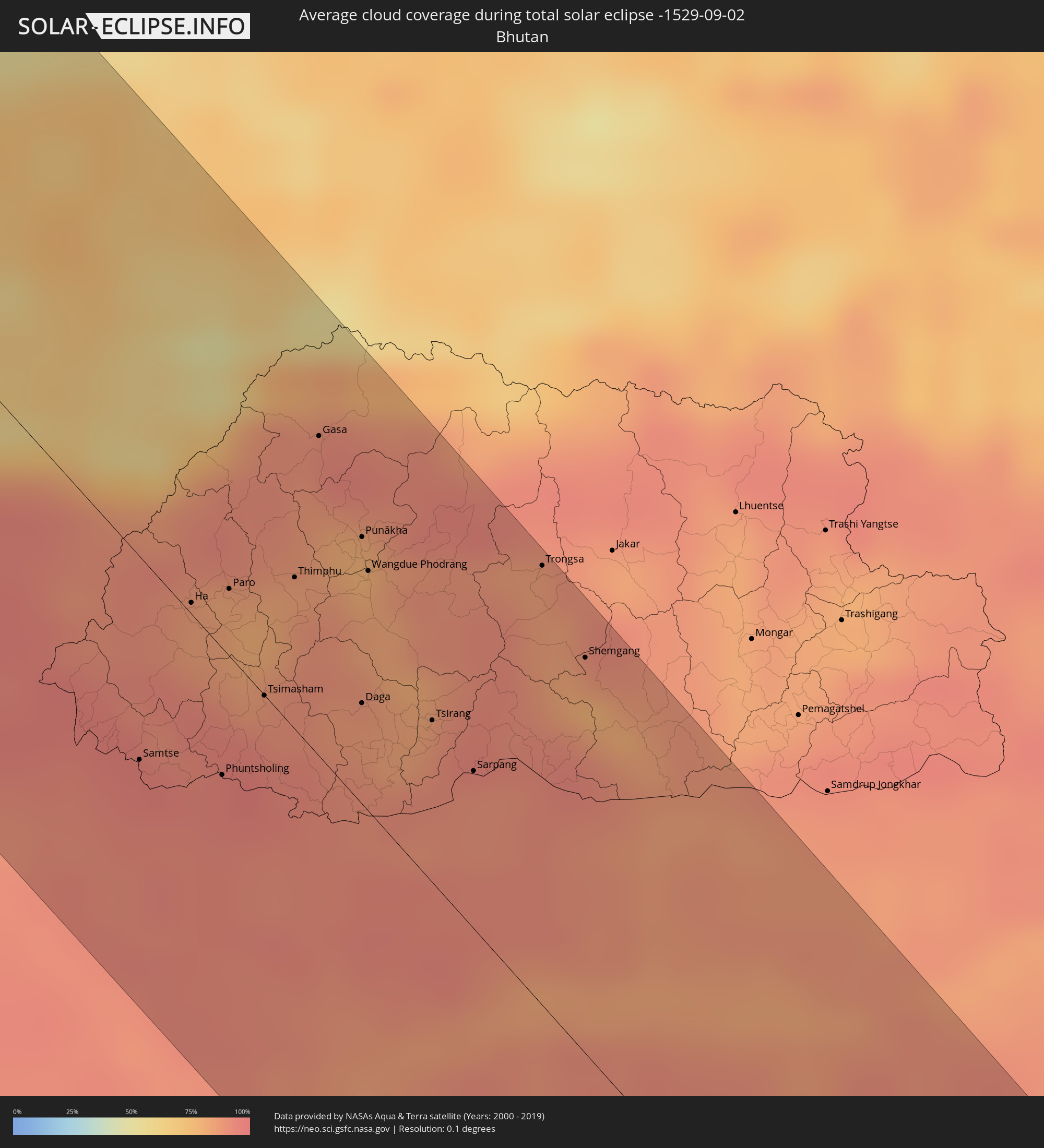 Bhutan
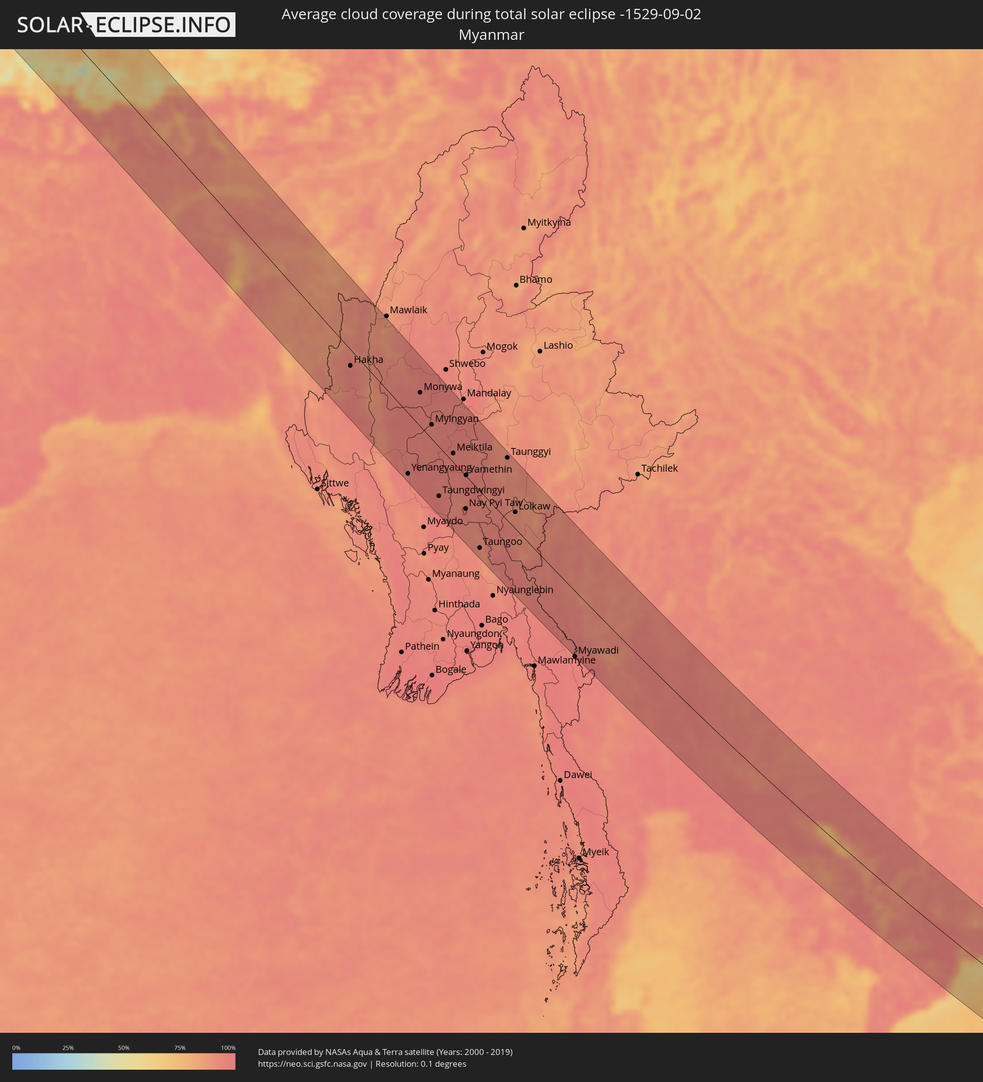 Myanmar
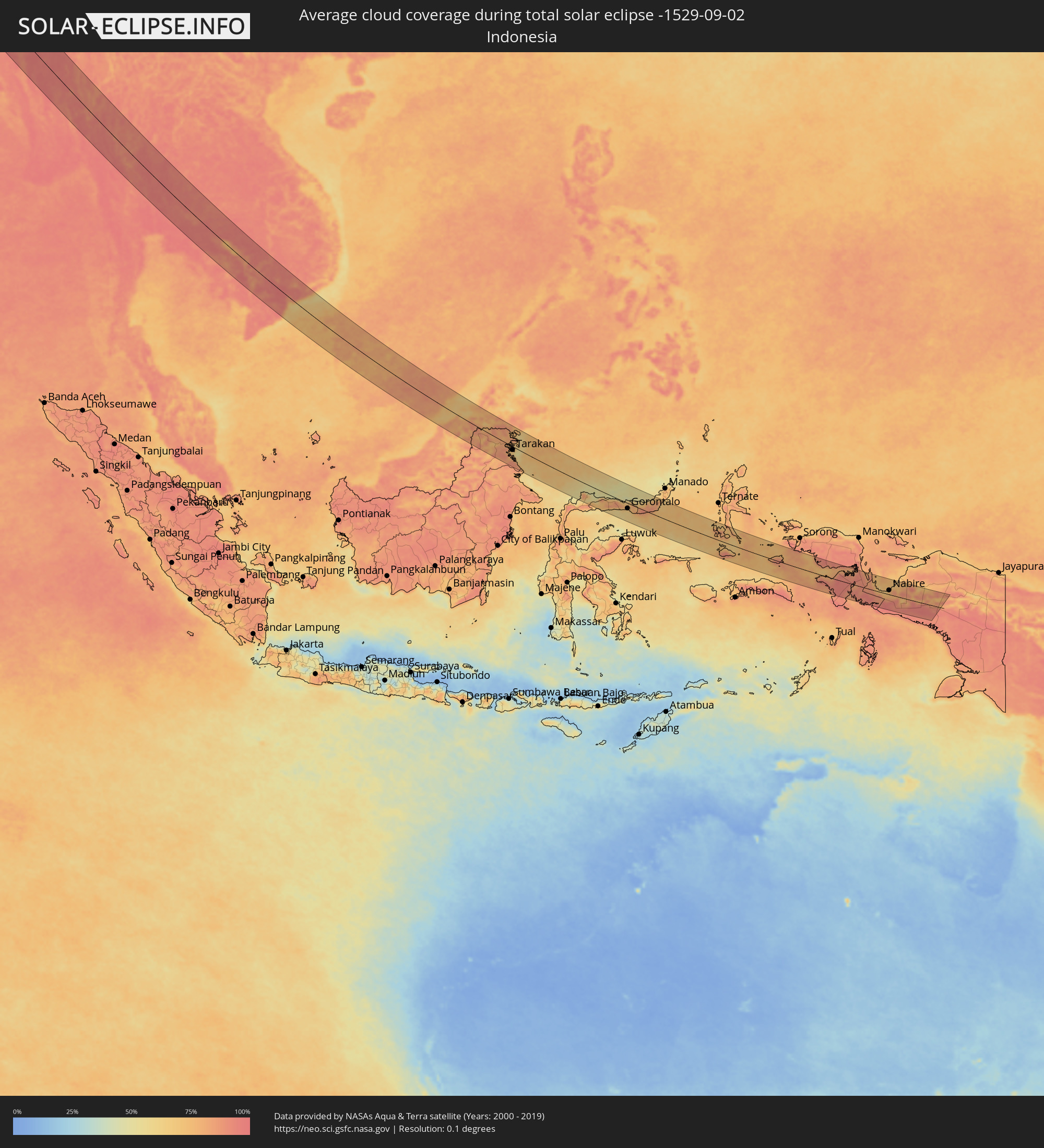 Indonesia
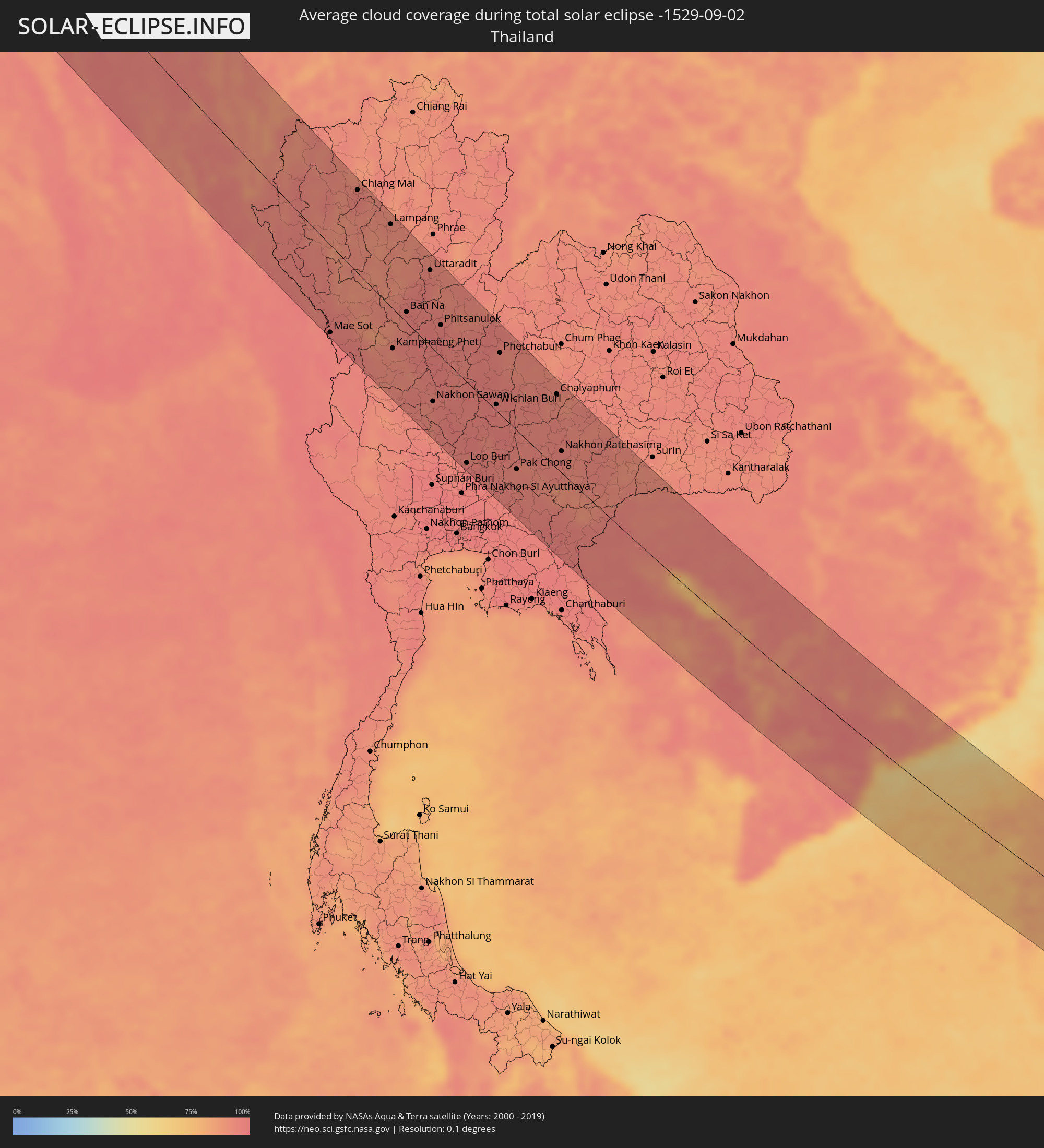 Thailand
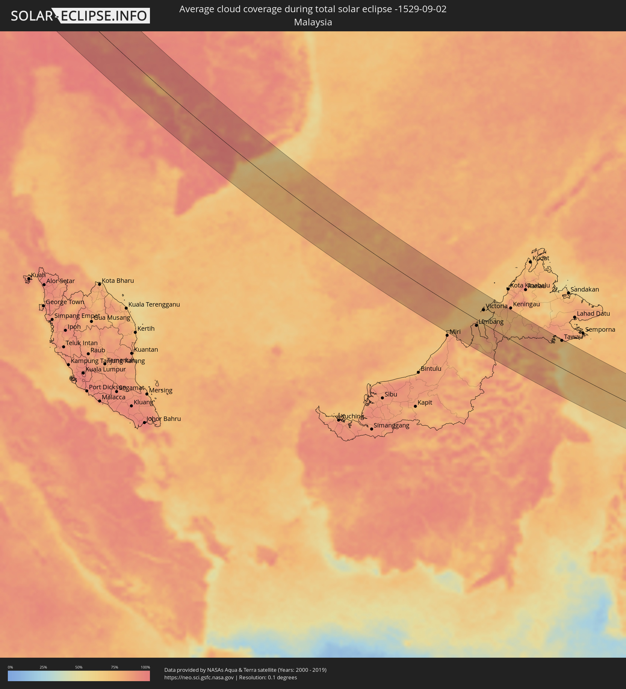 Malaysia
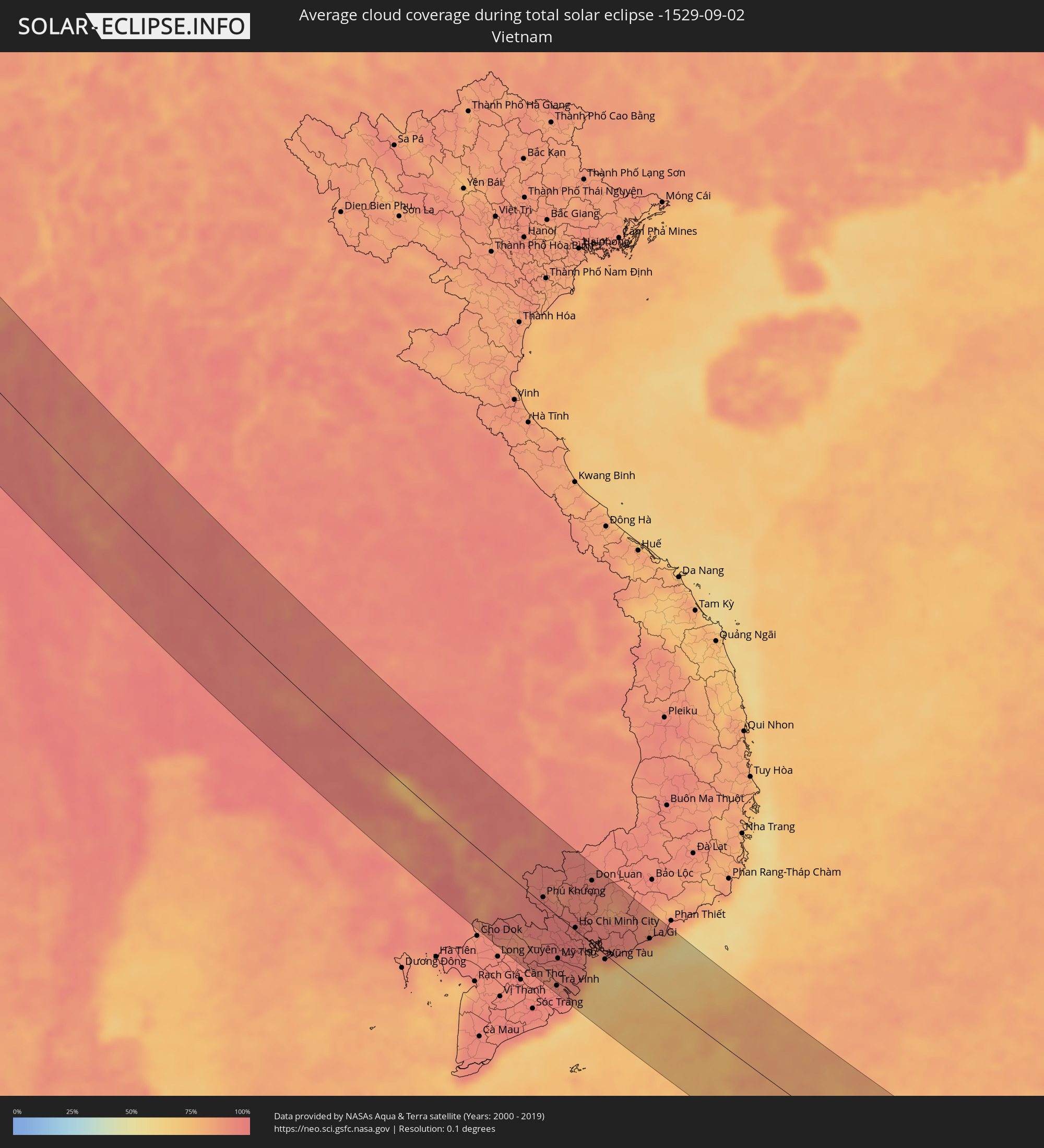 Vietnam
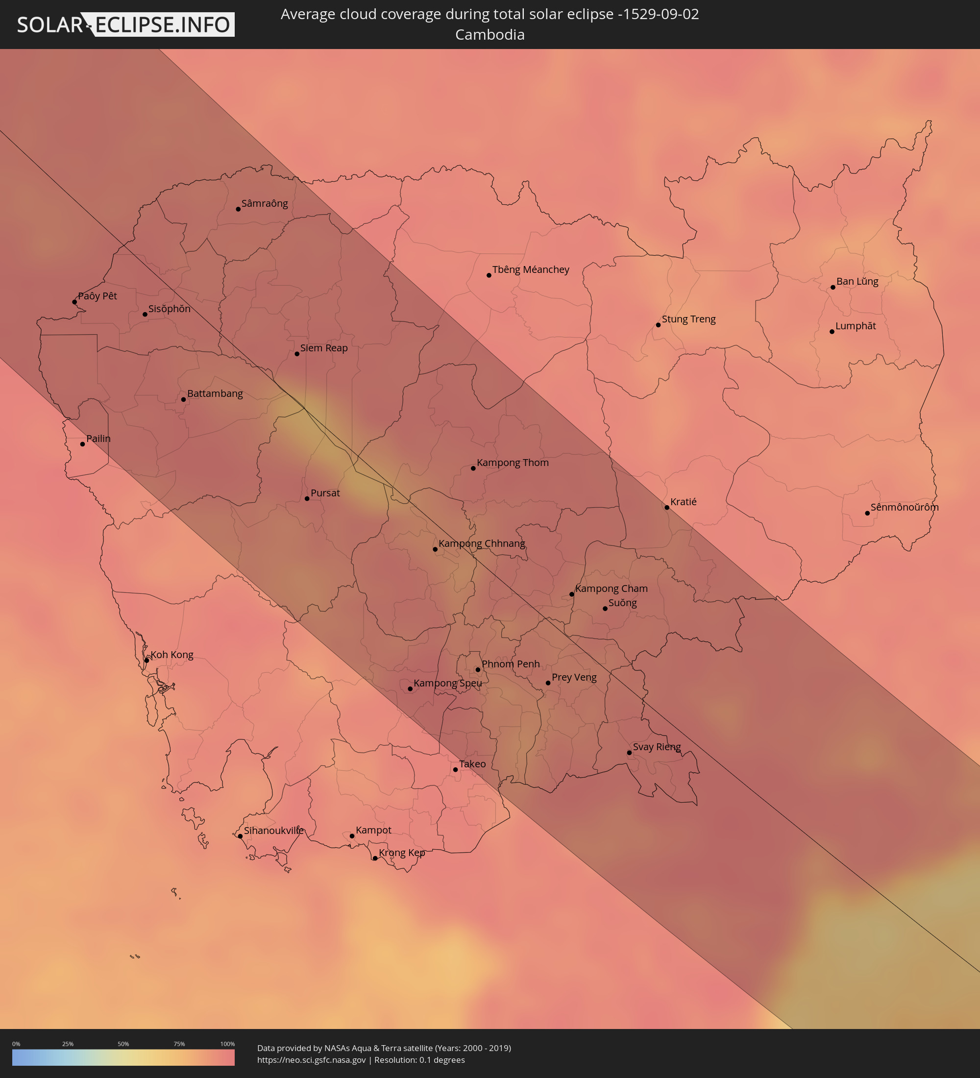 Cambodia
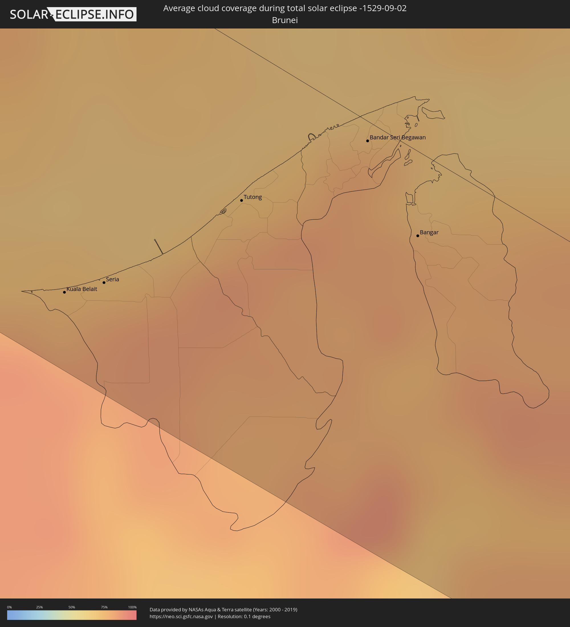 Brunei
Cities inside the path of the eclipse
The following table shows all locations with a population of more than 5,000 inside the eclipse path. Cities which have more than 100,000 inhabitants are marked bold. A click at the locations opens a detailed map.
| City | Type | Eclipse duration | Local time of max. eclipse | Distance to central line | Ø Cloud coverage |
|
Nantes, Pays de la Loire
|
total | - | 05:44:48 UTC+00:09 | 34 km | 57% |
|
Angers, Pays de la Loire
|
total | - | 05:44:57 UTC+00:09 | 38 km | 61% |
|
Le Mans, Pays de la Loire
|
total | - | 05:45:21 UTC+00:09 | 79 km | 67% |
|
Poitiers, Nouvelle-Aquitaine
|
total | - | 05:44:13 UTC+00:09 | 75 km | 60% |
|
Tours, Centre
|
total | - | 05:44:51 UTC+00:09 | 3 km | 63% |
|
Orléans, Centre
|
total | - | 05:45:16 UTC+00:09 | 33 km | 67% |
|
Bourges, Centre
|
total | - | 05:44:36 UTC+00:09 | 65 km | 67% |
|
Nancy, Grand-Est
|
total | - | 05:46:08 UTC+00:09 | 36 km | 70% |
|
Saarbrücken, Saarland
|
total | - | 06:37:20 UTC+01:00 | 82 km | 68% |
|
Strasbourg, Grand-Est
|
total | - | 05:46:14 UTC+00:09 | 2 km | 64% |
|
Freiburg, Baden-Württemberg
|
total | - | 06:36:24 UTC+01:00 | 67 km | 68% |
|
Karlsruhe, Baden-Württemberg
|
total | - | 06:37:20 UTC+01:00 | 34 km | 66% |
|
Heidelberg, Baden-Württemberg
|
total | - | 06:37:43 UTC+01:00 | 72 km | 72% |
|
Stuttgart, Baden-Württemberg
|
total | - | 06:37:16 UTC+01:00 | 3 km | 72% |
|
Heilbronn, Baden-Württemberg
|
total | - | 06:37:34 UTC+01:00 | 35 km | 74% |
|
Augsburg, Bavaria
|
total | - | 06:37:14 UTC+01:00 | 74 km | 68% |
|
Nürnberg, Bavaria
|
total | - | 06:38:11 UTC+01:00 | 41 km | 75% |
|
Regensburg, Bavaria
|
total | - | 06:38:02 UTC+01:00 | 21 km | 73% |
|
Pilsen, Plzeňský
|
total | - | 06:38:58 UTC+01:00 | 42 km | 77% |
|
Prague, Praha
|
total | - | 06:39:32 UTC+01:00 | 67 km | 71% |
|
České Budějovice, Jihočeský
|
total | - | 06:38:37 UTC+01:00 | 56 km | 72% |
|
Schrems, Lower Austria
|
total | - | 06:38:38 UTC+01:00 | 84 km | 72% |
|
Waidhofen an der Thaya, Lower Austria
|
total | - | 06:38:44 UTC+01:00 | 83 km | 72% |
|
Pardubice, Pardubický
|
total | - | 06:39:53 UTC+01:00 | 46 km | 72% |
|
Hradec Králové, Královéhradecký
|
total | - | 06:40:03 UTC+01:00 | 64 km | 69% |
|
Brno, South Moravian
|
total | - | 06:39:28 UTC+01:00 | 56 km | 66% |
|
Olomouc, Olomoucký
|
total | - | 06:40:00 UTC+01:00 | 18 km | 69% |
|
Zlín, Zlín
|
total | - | 06:39:51 UTC+01:00 | 63 km | 65% |
|
Ostrava, Moravskoslezský
|
total | - | 06:40:34 UTC+01:00 | 1 km | 67% |
|
Považská Bystrica, Trenčiansky
|
total | - | 06:40:03 UTC+01:00 | 82 km | 64% |
|
Rybnik, Silesian Voivodeship
|
total | - | 07:04:53 UTC+01:24 | 25 km | 67% |
|
Bytča, Žilinský
|
total | - | 06:40:11 UTC+01:00 | 71 km | 68% |
|
Jastrzębie Zdrój, Silesian Voivodeship
|
total | - | 07:04:47 UTC+01:24 | 9 km | 64% |
|
Gliwice, Silesian Voivodeship
|
total | - | 07:05:06 UTC+01:24 | 46 km | 68% |
|
Žilina, Žilinský
|
total | - | 06:40:15 UTC+01:00 | 73 km | 67% |
|
Kysucké Nové Mesto, Žilinský
|
total | - | 06:40:20 UTC+01:00 | 65 km | 69% |
|
Čadca, Žilinský
|
total | - | 06:40:26 UTC+01:00 | 50 km | 71% |
|
Katowice, Silesian Voivodeship
|
total | - | 07:05:12 UTC+01:24 | 39 km | 69% |
|
Bielsko-Biala, Silesian Voivodeship
|
total | - | 07:04:51 UTC+01:24 | 10 km | 69% |
|
Dąbrowa Górnicza, Silesian Voivodeship
|
total | - | 07:05:20 UTC+01:24 | 44 km | 69% |
|
Dolný Kubín, Žilinský
|
total | - | 06:40:28 UTC+01:00 | 80 km | 69% |
|
Kraków, Lesser Poland Voivodeship
|
total | - | 07:05:24 UTC+01:24 | 9 km | 69% |
|
Stará Ľubovňa, Prešovský
|
total | - | 06:41:07 UTC+01:00 | 81 km | 66% |
|
Tarnów, Lesser Poland Voivodeship
|
total | - | 07:05:48 UTC+01:24 | 4 km | 69% |
|
Bardejov, Prešovský
|
total | - | 06:41:22 UTC+01:00 | 86 km | 63% |
|
Svidník, Prešovský
|
total | - | 06:41:31 UTC+01:00 | 86 km | 59% |
|
Rzeszów, Subcarpathian Voivodeship
|
total | - | 07:06:17 UTC+01:24 | 7 km | 66% |
|
Lviv, Lviv
|
total | - | 07:45:10 UTC+02:02 | 41 km | 60% |
|
Luts’k, Volyn
|
total | - | 07:46:33 UTC+02:02 | 56 km | 60% |
|
Ternopil’, Ternopil
|
total | - | 07:45:48 UTC+02:02 | 79 km | 60% |
|
Rivne, Rivne
|
total | - | 07:46:55 UTC+02:02 | 38 km | 63% |
|
Zhytomyr, Zhytomyr
|
total | - | 07:48:06 UTC+02:02 | 6 km | 64% |
|
Kiev, Kyiv City
|
total | - | 07:49:24 UTC+02:02 | 15 km | 63% |
|
Poltava, Poltava
|
total | - | 07:51:45 UTC+02:02 | 70 km | 59% |
|
Sumy, Sumy
|
total | - | 07:52:42 UTC+02:02 | 78 km | 63% |
|
Kharkiv, Kharkiv
|
total | - | 07:53:19 UTC+02:02 | 18 km | 63% |
|
Belgorod, Belgorod
|
total | - | 08:22:07 UTC+02:30 | 54 km | 64% |
|
Shebekino, Belgorod
|
total | - | 08:22:17 UTC+02:30 | 33 km | 64% |
|
Alekseyevka, Belgorod
|
total | - | 08:23:52 UTC+02:30 | 71 km | 67% |
|
Rossosh’, Voronezj
|
total | - | 08:24:25 UTC+02:30 | 31 km | 61% |
|
Mikhaylovka, Volgograd
|
total | - | 08:27:43 UTC+02:30 | 56 km | 58% |
|
Frolovo, Volgograd
|
total | - | 08:28:02 UTC+02:30 | 30 km | 55% |
|
Volgograd, Volgograd
|
total | - | 08:28:35 UTC+02:30 | 74 km | 49% |
|
Volzhskiy, Volgograd
|
total | - | 08:28:53 UTC+02:30 | 62 km | 49% |
|
Kamyshin, Volgograd
|
total | - | 08:29:51 UTC+02:30 | 90 km | 50% |
|
Qulsary, Atyraū
|
total | - | 09:34:30 UTC+03:25 | 74 km | 24% |
|
Ayteke Bi, Qyzylorda
|
total | - | 10:42:08 UTC+04:21 | 58 km | 21% |
|
Baikonur, Baikonur
|
total | - | 10:43:53 UTC+04:21 | 77 km | 17% |
|
Kyzylorda, Qyzylorda
|
total | - | 10:47:30 UTC+04:21 | 86 km | 14% |
|
Shīeli, Qyzylorda
|
total | - | 10:49:47 UTC+04:21 | 70 km | 13% |
|
Turkestan, Ongtüstik Qazaqstan
|
total | - | 10:52:45 UTC+04:21 | 51 km | 8% |
|
Kentau, Ongtüstik Qazaqstan
|
total | - | 10:52:57 UTC+04:21 | 83 km | 8% |
|
Arys, Ongtüstik Qazaqstan
|
total | - | 10:54:24 UTC+04:21 | 5 km | 6% |
|
Tashkent, Toshkent Shahri
|
total | - | 11:02:11 UTC+04:27 | 94 km | 8% |
|
Chirchiq, Toshkent
|
total | - | 11:02:33 UTC+04:27 | 58 km | 5% |
|
Shymkent, Ongtüstik Qazaqstan
|
total | - | 10:55:44 UTC+04:21 | 19 km | 6% |
|
Angren, Toshkent
|
total | - | 11:03:54 UTC+04:27 | 73 km | 9% |
|
Shaydon, Viloyati Sughd
|
total | - | 11:11:55 UTC+04:35 | 95 km | 12% |
|
Qo‘qon, Fergana
|
total | - | 11:05:42 UTC+04:27 | 79 km | 14% |
|
Chust Shahri, Namangan
|
total | - | 11:05:37 UTC+04:27 | 22 km | 12% |
|
Namangan, Namangan
|
total | - | 11:06:20 UTC+04:27 | 1 km | 14% |
|
Fergana, Fergana
|
total | - | 11:07:12 UTC+04:27 | 51 km | 13% |
|
Iradan, Batken
|
total | - | 11:38:21 UTC+04:58 | 45 km | 16% |
|
Kyzyl-Kyya, Batken
|
total | - | 11:38:25 UTC+04:58 | 45 km | 16% |
|
Tash-Kumyr, Jalal-Abad
|
total | - | 11:37:18 UTC+04:58 | 57 km | 13% |
|
Asaka, Andijon
|
total | - | 11:07:37 UTC+04:27 | 5 km | 15% |
|
Andijon, Andijon
|
total | - | 11:07:37 UTC+04:27 | 13 km | 17% |
|
Nookat
|
total | - | 11:39:10 UTC+04:58 | 19 km | 21% |
|
Bazar-Korgon, Jalal-Abad
|
total | - | 11:38:28 UTC+04:58 | 56 km | 15% |
|
Osh City, Osh City
|
total | - | 11:39:09 UTC+04:58 | 15 km | 17% |
|
Kara Suu, Osh
|
total | - | 11:39:03 UTC+04:58 | 33 km | 17% |
|
Jalal-Abad, Jalal-Abad
|
total | - | 11:38:59 UTC+04:58 | 60 km | 16% |
|
Uzgen, Osh
|
total | - | 11:39:39 UTC+04:58 | 60 km | 19% |
|
Kashgar, Xinjiang Uyghur Autonomous Region
|
total | - | 14:47:06 UTC+08:00 | 90 km | 37% |
|
Shache, Xinjiang Uyghur Autonomous Region
|
total | - | 14:50:30 UTC+08:00 | 71 km | 54% |
|
Zangguy, Xinjiang Uyghur Autonomous Region
|
total | - | 14:54:34 UTC+08:00 | 65 km | 49% |
|
Dārjiling, West Bengal
|
total | - | 12:48:37 UTC+05:21 | 98 km | 94% |
|
Jalpāiguri, West Bengal
|
total | - | 12:50:19 UTC+05:21 | 103 km | 91% |
|
Goyerkāta, West Bengal
|
total | - | 12:50:23 UTC+05:21 | 67 km | 92% |
|
Samtse, Samchi
|
total | - | 13:27:33 UTC+05:58 | 47 km | 95% |
|
Jaigaon, West Bengal
|
total | - | 12:50:37 UTC+05:21 | 31 km | 94% |
|
Phuntsholing, Chukha District
|
total | - | 12:50:38 UTC+05:21 | 29 km | 95% |
|
Koch Bihār, West Bengal
|
total | - | 12:51:44 UTC+05:21 | 64 km | 92% |
|
Lalmanirhat, Rangpur Division
|
total | - | 13:24:41 UTC+05:53 | 95 km | 87% |
|
Tsimasham, Chukha District
|
total | - | 13:27:48 UTC+05:58 | 1 km | 93% |
|
Thimphu, Thimphu
|
total | - | 13:27:15 UTC+05:58 | 35 km | 82% |
|
Chilmāri, Rangpur Division
|
total | - | 13:25:43 UTC+05:53 | 105 km | 86% |
|
Nageswari, Rangpur Division
|
total | - | 13:24:57 UTC+05:53 | 73 km | 89% |
|
Daga, Dagana District
|
total | - | 13:28:20 UTC+05:58 | 23 km | 86% |
|
Punākha, Punakha
|
total | - | 13:27:21 UTC+05:58 | 62 km | 78% |
|
Tsirang, Chirang
|
total | - | 13:28:48 UTC+05:58 | 38 km | 86% |
|
Sarpang, Geylegphug
|
total | - | 13:29:19 UTC+05:58 | 37 km | 90% |
|
Trongsa, Tongsa
|
total | - | 13:28:26 UTC+05:58 | 102 km | 85% |
|
Netrakona, Dhaka
|
total | - | 13:28:33 UTC+05:53 | 76 km | 93% |
|
Kishorganj, Dhaka
|
total | - | 13:29:30 UTC+05:53 | 105 km | 94% |
|
Habiganj, Sylhet
|
total | - | 13:30:30 UTC+05:53 | 62 km | 94% |
|
Chhātak, Sylhet
|
total | - | 13:29:36 UTC+05:53 | 7 km | 90% |
|
Guwahati, Assam
|
total | - | 12:55:18 UTC+05:21 | 96 km | 88% |
|
Maulavi Bāzār, Sylhet
|
total | - | 13:30:48 UTC+05:53 | 27 km | 93% |
|
Sylhet, Sylhet
|
total | - | 13:30:08 UTC+05:53 | 11 km | 89% |
|
Shillong, Meghalaya
|
total | - | 12:56:41 UTC+05:21 | 61 km | 94% |
|
Aizawl, Mizoram
|
total | - | 13:01:25 UTC+05:21 | 12 km | 87% |
|
Silchar, Assam
|
total | - | 12:59:23 UTC+05:21 | 75 km | 87% |
|
Chauk, Magway
|
total | - | 14:13:20 UTC+06:24 | 64 km | 94% |
|
Yenangyaung, Magway
|
total | - | 14:14:15 UTC+06:24 | 93 km | 94% |
|
Pakokku, Magway
|
total | - | 14:12:50 UTC+06:24 | 11 km | 95% |
|
Monywa, Sagain
|
total | - | 14:11:24 UTC+06:24 | 51 km | 95% |
|
Myingyan, Mandalay
|
total | - | 14:12:59 UTC+06:24 | 22 km | 94% |
|
Meiktila, Mandalay
|
total | - | 14:14:42 UTC+06:24 | 14 km | 94% |
|
Nay Pyi Taw, Nay Pyi Taw
|
total | - | 14:17:13 UTC+06:24 | 51 km | 94% |
|
Taungoo, Bago
|
total | - | 14:19:08 UTC+06:24 | 89 km | 91% |
|
Taunggyi, Shan
|
total | - | 14:16:20 UTC+06:24 | 98 km | 92% |
|
Chiang Mai, Chiang Mai
|
total | - | 14:39:43 UTC+06:42 | 93 km | 95% |
|
Lampang, Lampang
|
total | - | 14:41:14 UTC+06:42 | 94 km | 92% |
|
Kamphaeng Phet, Kamphaeng Phet
|
total | - | 14:44:38 UTC+06:42 | 46 km | 91% |
|
Uttaradit, Uttaradit
|
total | - | 14:43:09 UTC+06:42 | 87 km | 95% |
|
Nakhon Sawan, Nakhon Sawan
|
total | - | 14:46:44 UTC+06:42 | 61 km | 93% |
|
Phitsanulok, Phitsanulok
|
total | - | 14:44:48 UTC+06:42 | 37 km | 97% |
|
Saraburi, Sara Buri
|
total | - | 14:49:41 UTC+06:42 | 97 km | 96% |
|
Chaiyaphum, Chaiyaphum
|
total | - | 14:48:31 UTC+06:42 | 88 km | 93% |
|
Nakhon Ratchasima, Nakhon Ratchasima
|
total | - | 14:50:06 UTC+06:42 | 26 km | 95% |
|
Paôy Pêt, Banteay Meanchey
|
total | - | 14:52:54 UTC+06:42 | 47 km | 96% |
|
Battambang, Battambang
|
total | - | 14:54:29 UTC+06:42 | 47 km | 97% |
|
Siem Reap, Siem Reap
|
total | - | 14:54:39 UTC+06:42 | 23 km | 96% |
|
Pursat, Pursat
|
total | - | 14:56:07 UTC+06:42 | 42 km | 89% |
|
Kampong Speu, Kampong Speu
|
total | - | 14:58:31 UTC+06:42 | 90 km | 95% |
|
Kampong Chhnang, Kampong Chhnang
|
total | - | 14:57:18 UTC+06:42 | 12 km | 88% |
|
Phnom Penh, Phnom Penh
|
total | - | 14:58:41 UTC+06:42 | 53 km | 94% |
|
Prey Veng, Prey Veng
|
total | - | 14:59:10 UTC+06:42 | 30 km | 86% |
|
Kampong Cham, Kampong Cham
|
total | - | 14:58:26 UTC+06:42 | 22 km | 88% |
|
Vĩnh Long, Vĩnh Long
|
total | - | 15:26:20 UTC+07:06 | 91 km | 93% |
|
Mỹ Tho, Tiền Giang
|
total | - | 15:26:29 UTC+07:06 | 55 km | 95% |
|
Củ Chi, Ho Chi Minh City
|
total | - | 15:25:36 UTC+07:06 | 7 km | 97% |
|
Ho Chi Minh City, Ho Chi Minh City
|
total | - | 15:25:57 UTC+07:06 | 4 km | 97% |
|
Thủ Dầu Một, Bình Dương
|
total | - | 15:25:43 UTC+07:06 | 19 km | 96% |
|
Cần Giuộc, Long An
|
total | - | 15:26:20 UTC+07:06 | 12 km | 95% |
|
Biên Hòa, Đồng Nai
|
total | - | 15:25:55 UTC+07:06 | 28 km | 95% |
|
Vũng Tàu, Bà Rịa-Vũng Tàu
|
total | - | 15:27:06 UTC+07:06 | 7 km | 65% |
|
La Gi, Bình Thuận
|
total | - | 15:27:08 UTC+07:06 | 68 km | 79% |
|
Kuala Belait, Belait
|
total | - | 16:13:16 UTC+07:39 | 80 km | 77% |
|
Seria, Belait
|
total | - | 16:13:17 UTC+07:39 | 72 km | 80% |
|
Tutong, Tutong
|
total | - | 16:13:12 UTC+07:39 | 35 km | 81% |
|
Bandar Seri Begawan, Brunei and Muara
|
total | - | 16:13:10 UTC+07:39 | 4 km | 81% |
|
Limbang, Sarawak
|
total | - | 15:55:06 UTC+07:21 | 20 km | 81% |
|
Bangar, Temburong
|
total | - | 16:13:31 UTC+07:39 | 19 km | 80% |
|
Victoria, Labuan
|
total | - | 15:54:31 UTC+07:21 | 44 km | 73% |
|
Bandar Labuan, Sabah
|
total | - | 15:54:31 UTC+07:21 | 47 km | 72% |
|
Beaufort, Sabah
|
total | - | 15:54:41 UTC+07:21 | 80 km | 77% |
|
Sembakung, East Kalimantan
|
total | - | 16:33:36 UTC+07:57 | 15 km | 79% |
|
Tanjung Selor, North Kalimantan
|
total | - | 16:34:52 UTC+07:57 | 75 km | 88% |
|
Tarakan, North Kalimantan
|
total | - | 16:34:23 UTC+07:57 | 16 km | 68% |
|
Tawau, Sabah
|
total | - | 15:57:04 UTC+07:21 | 91 km | 71% |
|
Gorontalo, Gorontalo
|
total | - | 16:39:18 UTC+07:57 | 25 km | 69% |
|
Nabire, Papua
|
total | - | 18:08:45 UTC+09:22 | 21 km | 75% |